appendix d biological report - irwindale, ca
TRANSCRIPT

C I T Y O F H O P E C A M P U S P L A N D R A F T E I R C I T Y O F D U A R T E
Appendices
November 2017
Appendix D Biological Report

C I T Y O F H O P E C A M P U S P L A N D R A F T E I R C I T Y O F D U A R T E
Appendices
PlaceWorks
This page intentionally left blank.
CADREEnvironmentalFebruary 2017
City of Hope Campus Plan, City of DuarteLos Angeles County, California
Prepared for:
PLACEWORKS3 MacArthur Place, Suite 1100Santa Ana, CA 92707Contact: Nicole Morse, (714) 966-9220
Prepared by:
Cadre Environmental701 Palomar Airport Road, Suite 300Carlsbad, CA 92011Contact: Ruben Ramirez, (949) 300-0212
FINAL REPORT
Biological Resources Technical Report
D-1
Biological Resources Technical Report City of Hope Campus Plan Cadre Environmental February 2017
i
TABLE OF CONTENTS
PAGE
INTRODUCTION 1
111
4
4
4
5
7
PROJECT LOCATION 1
PROJECT DESCRIPTION 4
METHODOLOGY 4
LITERATURE REVIEW 4
FIELD SURVEY 5
EXISTING ENVIRONMENTAL SETTING 6
VEGETATION COMMUNITIES 7
GENERAL PLANT & WILDLIFE SPECIES 11
JURISDICTIONAL WETLAND RESOURCES 12
SENSITIVE BIOLOGICAL RESOURCES 12
FEDERAL PROTECTION AND CLASSIFICATIONS 13
STATE PROTECTION AND CLASSIFICATIONS 14
SENSITIVE HABITATS 16
SENSITIVE PLANTS 17
SENSITIVE WILDLIFE 18
JURISDICTIONAL WETLAND RESOURCES 22
ENVIRONMENTAL IMPACTS 22
THRESHOLD OF SIGNIFICANCE 22
DIRECT IMPACTS 23
INDIRECT IMPACTS 27
CUMMULATIVE IMPACTS 28
MITIGATION MEASURES 28
LITERATURE CITED 30
D-2
Biological Resources Technical Report City of Hope Campus Plan Cadre Environmental February 2017
ii
LIST OF FIGURES
PAGE
1 – Regional Location Map
2
2 – Project Site Map 3
3 – Vegetation Communities Map 8
4 – Current Project Site Photographs 9
5 – Current Project Site Photographs 10
6 – USFWS Sensitive Species Occurrences 21
LIST OF TABLES
PAGE
1 – Project Site Vegetation Community Acreages 11
2 – Sensitive Plant Species Assessment 17
3 – Sensitive Wildlife Species Assessment 19
4 – Project Site Vegetation Community Potential Temporary/Permanent Impacts
25
D-3

Biological Resources Technical Report City of Hope Campus Plan Cadre Environmental February 2017
1
INTRODUCTION
The following biological resources technical report describes a detailed assessment of potential sensitive natural resources located within and/or immediately adjacent to the City of Hope Campus plan project site (Project Site). The report has been prepared to support compliance with the California Environmental Quality Act (CEQA) documentation including the preparation of an Environmental Impact Report (EIR) and environmental review process conducted by the City of Duarte, California. As discussed below, the assessment included a thorough literature review, site reconnaissance characterizing existing conditions (including floral, faunal and dominant vegetation communities), impact analysis, and development of proposed mitigation measures to reduce impacts to a level of less than significant. As stated by PlaceWorks:
“The project applicant, City of Hope National Medical Center (City of Hope), is seeking approval of the City of Hope Campus Plan, which through a comprehensive Specific Plan would provide direction for the enhancement and development of the City of Hope campus over a period of 20 years, including the replacement of existing outdated and/or obsolete buildings with modern facilities. Specifically, City of Hope proposes additions to the existing outpatient (clinic), inpatient (hospital), research, office, industrial, warehouse, and hospitality uses at its main campus. New parking structures, surface parking lots, internal roadways, pedestrian and open space improvements are also proposed. Improvements would support the applicant’s efforts to expand its research and treatment capabilities in order to ensure continued advances in the treatment and research of cancer, diabetes, and other life-threatening diseases, while accommodating the needs of patients and their families, faculty, staff, and the community. The Specific Plan would be a guide and vision for the long-term improvements that will enable City of Hope to meet its commitment to transform the future of medicine.” (PlaceWorks 2015)
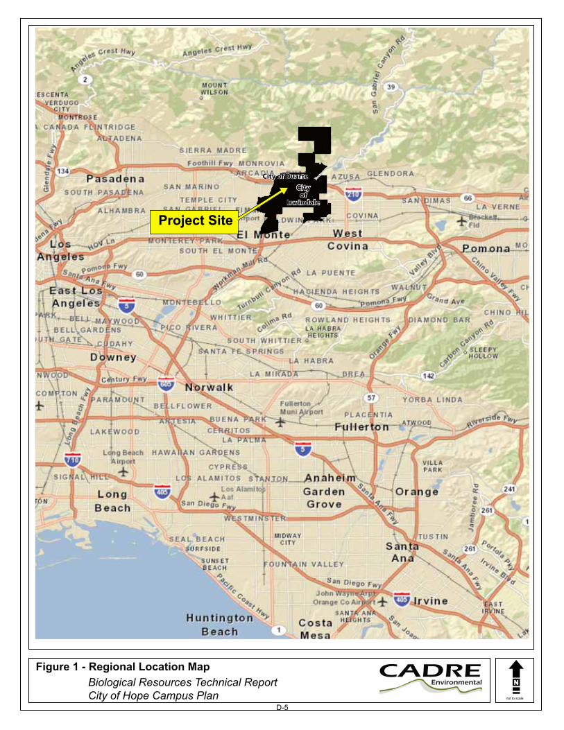
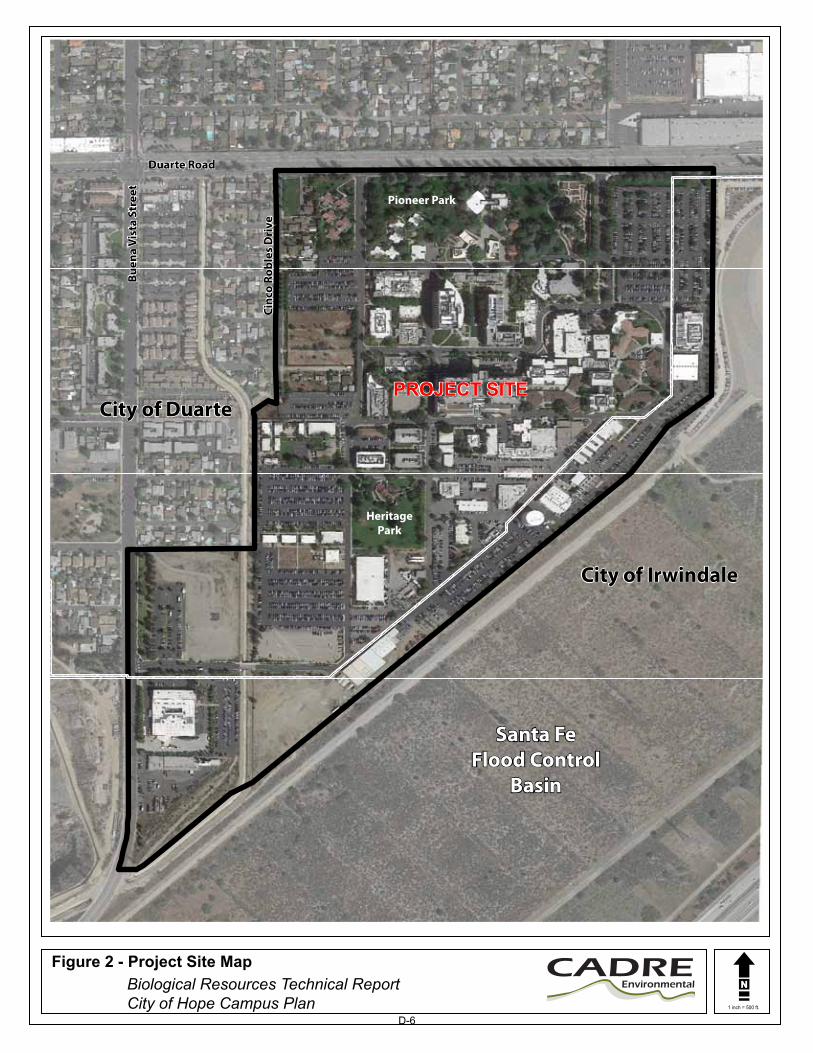
PROJECT LOCATION The 116-acre Project Site is located completely within Los Angeles County near the base of the San Gabriel Mountains, immediately south of Interstate 215 and west of Interstate 605 as shown in Figure 1, Regional Location Map. Specifically, the Project Site is primarily located in the City of Duarte (89.5 acres) and partially within the City of Irwindale (26.5 acres) as shown in Figure 2, Project Site Map. The Project Site is bordered by Duarte Road to the north, Cinco Robles and Buena Vista Street on the western boundary, and the Santa Fe Flood Control Basin to the east and south. The southwestern region of the Project Site is bisected by the Duarte Flood Control Channel.
D-4
not to scale
Figure 1 - Regional Location Map Biological Resources Technical Report
City of Hope Campus Plan
CADREEnvironmental
City of DurateCity of Duarte
Project Site
Cityof
Irwindale
Cityof
Irwindale
D-5
1 inch = 500 ft.
Figure 2 - Project Site Map Biological Resources Technical Report
City of Hope Campus Plan
CADREEnvironmental
PROJECT SITEPROJECT SITECity of DuarteCity of Duarte
City of IrwindaleCity of Irwindale
Pioneer Park
HeritagePark
Buen
a Vi
sta
Stre
et
Cinc
o Ro
bles
Dri
ve
Duarte Road
Santa FeFlood Control
Basin
Santa FeFlood Control
Basin
Buen
a Vi
sta
Stre
et
Cinc
o Ro
bles
Dri
ve
Duarte Road
D-6

Biological Resources Technical Report City of Hope Campus Plan Cadre Environmental February 2017
4
PROJECT DESCRIPTION The project applicant is seeking approval of a Specific Plan developed for City of Hope Campus for the purpose of providing direction for enhancement and development over a 20-year period. As stated by PlaceWorks:
“City of Hope (project applicant) is seeking approval of a Specific Plan, which would provide comprehensive direction for enhancement and development of its approximately 116-acre campus (less than one half acre is not owned by City of Hope) adjacent to the campus over a 20-year period. City of Hope proposes additions to the existing outpatient (clinic), inpatient (hospital), research, office, industrial, warehouse, and hospitality uses. New parking structures and surface parking lots are also proposed, as well as internal driveways and open space improvements. These changes and improvements throughout the campus would be implemented primarily through the Specific Plan, which would govern future development of the campus, supporting City of Hope’s efforts to expand its research and treatment capabilities, while accommodating the needs of patients and their families, faculty, staff, and the community.” (PlaceWorks 2015)
METHODOLOGY
The following section details the methods implemented prior and during the reconnaissance survey conducted throughout the Project Site. LITERATURE REVIEW Existing biological resource conditions within and adjacent to the Project Site were initially investigated through review of pertinent scientific literature. Federal register listings, protocols, and species data provided by the United States Fish and Wildlife Service (USFWS) were also reviewed in conjunction with anticipated federally listed species potentially occurring within the region of the Project Site. The California Natural Diversity Database (CNDDB) (CDFW 2016a), a California Department of Fish and Wildlife (CDFW) Natural Heritage Division species account database, was also reviewed for all pertinent information regarding the locations of known occurrences of sensitive species in the vicinity of the property. In addition, numerous regional floral and faunal field guides were utilized in the identification of species and suitable habitats. Combined, the reviewed sources provided an excellent baseline from which to inventory the biological resources potentially occurring in the area. Other sources of information included the review of unpublished biological resource letter reports and assessments. Other CDFW reports and publications consulted include the following:
Special Animals (CDFW 2016b);
Special Vascular Plants and Bryophytes List (CDFW 2016c);
Endangered, Threatened, and Rare Plants of California (CDFW 2016d); and
State and Federally Listed Endangered and Threatened Animals of California (CDFW 2016e);
D-7
Biological Resources Technical Report City of Hope Campus Plan Cadre Environmental February 2017
5
FIELD SURVEY A reconnaissance survey of the Project Site was conducted by Ruben Ramirez of Cadre Environmental on January 21st, 2016 in order to characterize and identify potential sensitive plant and wildlife habitats, and to establish the accuracy of the data identified in the literature search. Geologic and soil maps were examined to identify local soil types that may support sensitive taxa. Aerial photograph, topographic maps, vegetation and rare plant maps prepared for previous studies in the region were used to determine community types and other physical features that may support sensitive plants/wildlife, uncommon taxa, or rare communities that occur within or adjacent to the Project Site. Habitat assessments were conducted for, but not limited to, the following target species/groups.
Coastal California gnatcatcher – FT/SSC
Least Bell’s vireo – FE/SE
Southwestern willow flycatcher – FE/SE
Sensitive plants
Protected street trees (City of Duarte Municipal Code, Chapter 13.08)
Vegetation Communities/Habitat Classification Mapping Natural community names and hierarchical structure follows the CDFW “List of California Terrestrial Natural Communities” and/or Holland (1986) classification systems, which have been refined and augmented where appropriate to better characterize the habitat types observed onsite. Floristic Plant Inventory A general plant survey was conducted throughout the Project Site during the reconnaissance in a collective effort to identify all species occurring onsite. All plants observed during the survey efforts were either identified in the field or collected and later identified using taxonomic keys. Plant taxonomy follows Hickman (1993). Scientific nomenclature and common names used in this report generally follow Roberts et al. (2004) or Baldwin et al. (2012) for updated taxonomy. Scientific names are included only at the first mention of a species; thereafter, common names alone are used. Wildlife Resources Inventory All animals identified during the reconnaissance survey by sight, call, tracks, scat, or other characteristic sign were documented. In addition to species actually detected, expected use of the site by other wildlife was derived from the analysis of habitats on the site, combined with known habitat preferences of regionally occurring wildlife species. Vertebrate taxonomy followed in this report is according to the Center for North American Herpetology (2016 for amphibians and reptiles), the American Ornithologists’ Union (1988 and supplemental) for birds, and Baker et al. (2003) for mammals. Both
D-8
Biological Resources Technical Report City of Hope Campus Plan Cadre Environmental February 2017
6
common and scientific names are used during the first mention of a species; common names only are used in the remainder of the text.
Jurisdictional Wetlands Assessment The Project Site was assessed for jurisdiction by the United States Army Corps of Engineers (USACE), CDFW, and Regional Water Quality Control Board (RWQCB). Non-wetland waters of the United States were assessed based on the limits of the Ordinary High Water Mark (OHWM) as determined by erosion, the deposition of vegetation or debris, and changes in vegetation and soil characteristics. The assessment utilized the methodology for routine wetland determination according to the methods outlined in the USACE Wetland Delineation Manual (Environmental Laboratory 1987) and the Arid West Wetland Delineation Supplement (USACE 2008), and updated regulatory guidance letters. Wetlands are identified by the presence of three characteristics: hydrophytic vegetation, wetland hydrology, and hydric soils. If any of these criteria were met, one or more transects were run to determine the extent of the wetland. Specifically, the presence of wetland hydrology was evaluated throughout the Project Site by recording the extent of observed surface flows, depth of inundation, depth to saturated soils, and depth to free water in the soil pits, where applicable. In addition, indicators of wetland or riverine hydrology were recorded, including water marks, drift lines, rack, debris, and sediment deposits, as warranted. Any indicators of hydric soils, such as redoximorphic features, buried organic matter, organic streaking, reduced soil conditions, gleyed or low-chroma soils, or sulfidic odor were also recorded.
EXISTING ENVIRONMENTAL SETTING
The following section presents the existing conditions of the Project Site assessment area. As stated by PlaceWorks:
“City of Hope is an independent, nonprofit, comprehensive medical center and research facility. The 116-acre campus is comprised of landscaped gardens and open spaces which surround leading-edge medical and research facilities, including: City of Hope Helford Clinical Research Hospital (inpatient), Geri and Richard Brawerman Center for Ambulatory Care (outpatient), Michael Amini Transfusion Medicine Center (blood donor center and outpatient surgery), Rita Cooper Finkel and J. William Finkel Building, Sheri & Les Biller Patient and Family Resource Center, Arnold and Mabel Beckman Center for Cancer Immunotherapeutics & Tumor Immunology, Leslie & Susan Gonda (Goldschmied) Diabetes & Genetic Research Center. Overall, City of Hope campus is developed with a mix of hospital-related uses, including office, industrial, warehouse, assembly, hospitality (short-term stay housing provided by City of Hope for family members of patients and guests), and housing (residential), that total approximately 1.6 million gross square feet of building space. The existing housing consists of four rental units on three lots along the east side of Cinco Robles Drive, which are owned by City of Hope and used primarily for graduate student
D-9

Biological Resources Technical Report City of Hope Campus Plan Cadre Environmental February 2017
7
housing (i.e., rented primarily by graduate students attending City of Hope’s Irell & Manella Graduate School of Biological Sciences). City of Hope also owns several vacant parcels (approximately 2.5 acres) of land along the south and east sides of Cinco Robles Drive. Although not part of the City of Hope campus, there are six single family residences that are not owned by City of Hope on the east side of Cinco Robles Drive that are proposed for inclusion in the Specific Plan because they are surrounded by City of Hope-owned properties. The Specific Plan will allow these single family residential uses to remain residential uses, and will not require them to be incorporated into the campus. In addition, City of Hope's central utility plant is along the southern end of the project site, along with other campus warehouse and industrial uses. The project site is in an urbanized area. One- and two-story, single- and multifamily residential uses are directly west of the project site; similar residential uses are to the north across Duarte Road and the Los Angeles County Metropolitan Transportation Authority (Metro) railroad right-of-way for the Gold Line. The City of Duarte recently approved the Duarte Station Specific Plan, which would allow the construction of a transit-oriented, mixed-use development with high-density residential, office, hotel, and commercial uses. The Duarte/City of Hope Gold Line station, which is constructed with passenger service to begin in 2016, is north of the project site across Duarte Road on the southern boundary of the Duarte Station Specific Plan. To the south and east of the project site lies the Santa Fe Dam and San Gabriel River flood control facilities owned by the US Army Corps of Engineers (Corps). These areas are used for flood control, groundwater recharge, and community recreation.” (PlaceWorks 2015)
VEGETATION COMMUNITIES The 116-acre Project Site is dominated by developed, ornamental, disturbed and ruderal vegetation communities as described in this report, and illustrated in Figure 3, Vegetation Communities Map, and Figures 4 and 5, Current Project Site Photographs. Natural community names and hierarchical structure follows the CDFW “List of California Terrestrial Natural Communities” and/or Holland (1986) classification systems, which have been refined and augmented where appropriate to better characterize the habitat types observed. Developed The majority of the 116-acre Project Site is characterized as 82.1-acres of developed areas (71%) which are associated with existing roads, concrete lined Duarte Flood Control Channel, hospital-related uses, including office, industrial, warehouse, assembly, and hospitality housing facilities as outlined in Table 1, Project Site Vegetation Community Acreages.
D-10

1 inch = 500 ft.
Figure 3 - Vegetation Communities Map Biological Resources Technical Report
City of Hope Campus Plan
CADREEnvironmental
PROJECT SITEPROJECT SITECity of DuarteCity of Duarte
City of IrwindaleCity of Irwindale
Pioneer Park
HeritagePark
Disturbed
Ruderal
Ornamental
Developed
Vegetation Communities
Dua
rte
Floo
d Co
ntro
l Cha
nnel
Buen
a Vi
sta
Stre
et
Cinc
o Ro
bles
Dri
ve
Duarte Road
Santa FeFlood Control
Basin
Santa FeFlood Control
Basin
Buen
a Vi
sta
Stre
et
Cinc
o Ro
bles
Dri
ve
Duarte Road
D-11
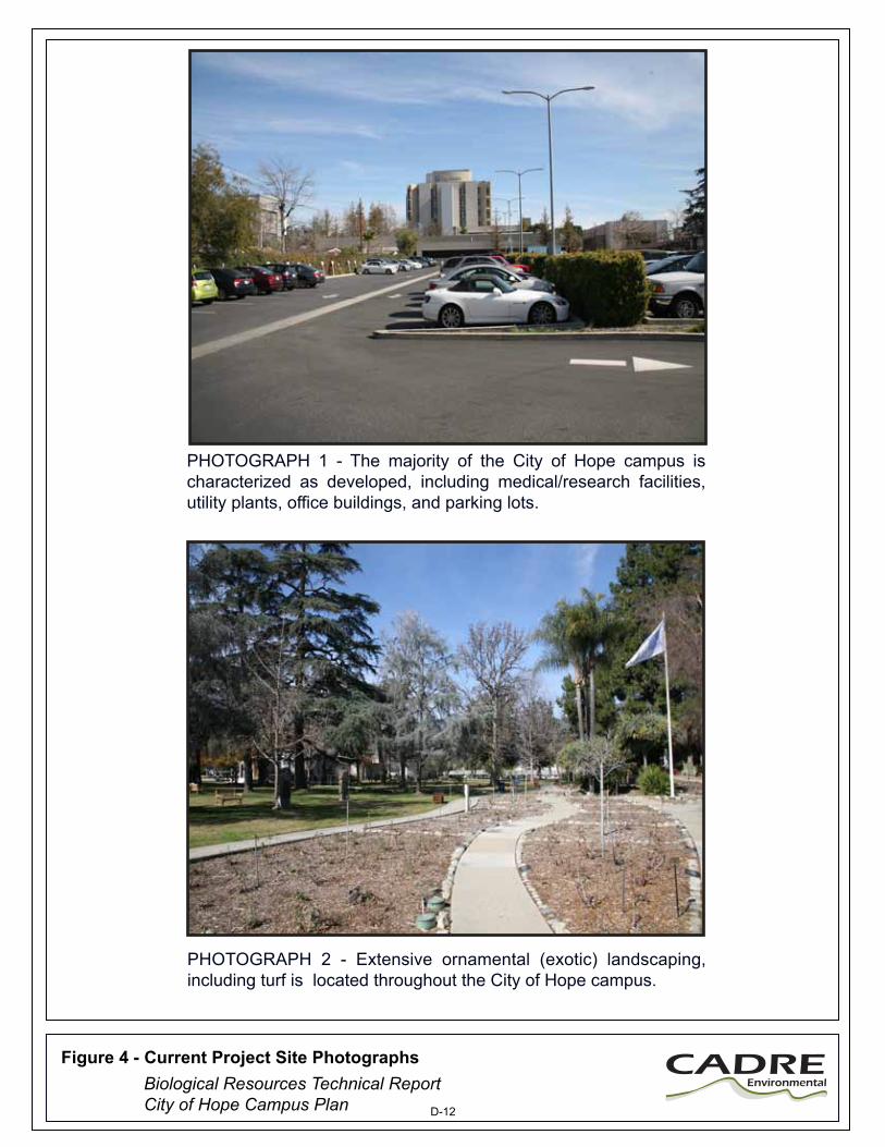
PHOTOGRAPH 1 - The majority of the City of Hope campus is characterized as developed, including medical/research facilities, utility plants, office buildings, and parking lots.
PHOTOGRAPH 2 - Extensive ornamental (exotic) landscaping, including turf is located throughout the City of Hope campus.
CADREEnvironmental
Figure 4 - Current Project Site Photographs Biological Resources Technical ReportCity of Hope Campus Plan D-12
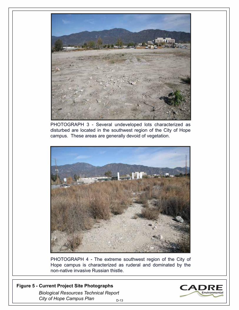
PHOTOGRAPH 3 - Several undeveloped lots characterized as disturbed are located in the southwest region of the City of Hope campus. These areas are generally devoid of vegetation.
PHOTOGRAPH 4 - The extreme southwest region of the City of Hope campus is characterized as ruderal and dominated by the non-native invasive Russian thistle.
CADREEnvironmental
Figure 5 - Current Project Site Photographs Biological Resources Technical ReportCity of Hope Campus Plan D-13
Biological Resources Technical Report City of Hope Campus Plan Cadre Environmental February 2017
11
Ornamental An extensive assortment of ornamental landscaped plantings representing 21.1-acres (18%) are located adjacent to existing developed areas including within Pioneer and Heritage Parks. Ornamental plantings include, but are not limited to turf, pine (Pinus sp.), shrub verbenas (Lantana sp.), rose (Rosa sp.), creeping myoporum (Myoporum parvifolium), fountain grass (Pennisetum setaceum), rosemary (Rosmarinus officinalis), Eucalyptus (Eucalyptus sp.), Chinese elm (Ulmus parvifolia), Brazilian pepper (Schinus terebinthifolius), magnolia (Magnolia sp.) and various species of exotic succulents.
Disturbed Disturbed areas of the Project Site are generally devoid of vegetation and represent 10.9-acres (9%), primarily located in the southwestern region. These areas are periodically cleared and dominated by filaree (Erodium sp.), black mustard (Brassica nigra), telegraph weed (Heterotheca grandiflora), Mediterranean schismus (Schismus barbatus), castor bean (Ricinus communis), Russian thistle (Kali tragus), tobacco tree (Nicotiana glauca), and horehound (Marrubium vulgare). A few isolated native plants, shrubs and trees occur within this habitat type including a single coast live oak (Quercus agrifolia), laurel sumac (Malosma laurina), California croton (Croton californicus), and California sagebrush (Artemisia californica). These native species are common offsite along the southeastern Project Site boundary within the Santa Fe Flood Control Basin. Ruderal A 1.9-acre (1.6%) patch of ruderal vegetation is located at the extreme southwestern tip of the Project Site. This area is bisected by a disturbed road and bordered/dominated by Russian thistle and deerweed (Acmispon glaber) .
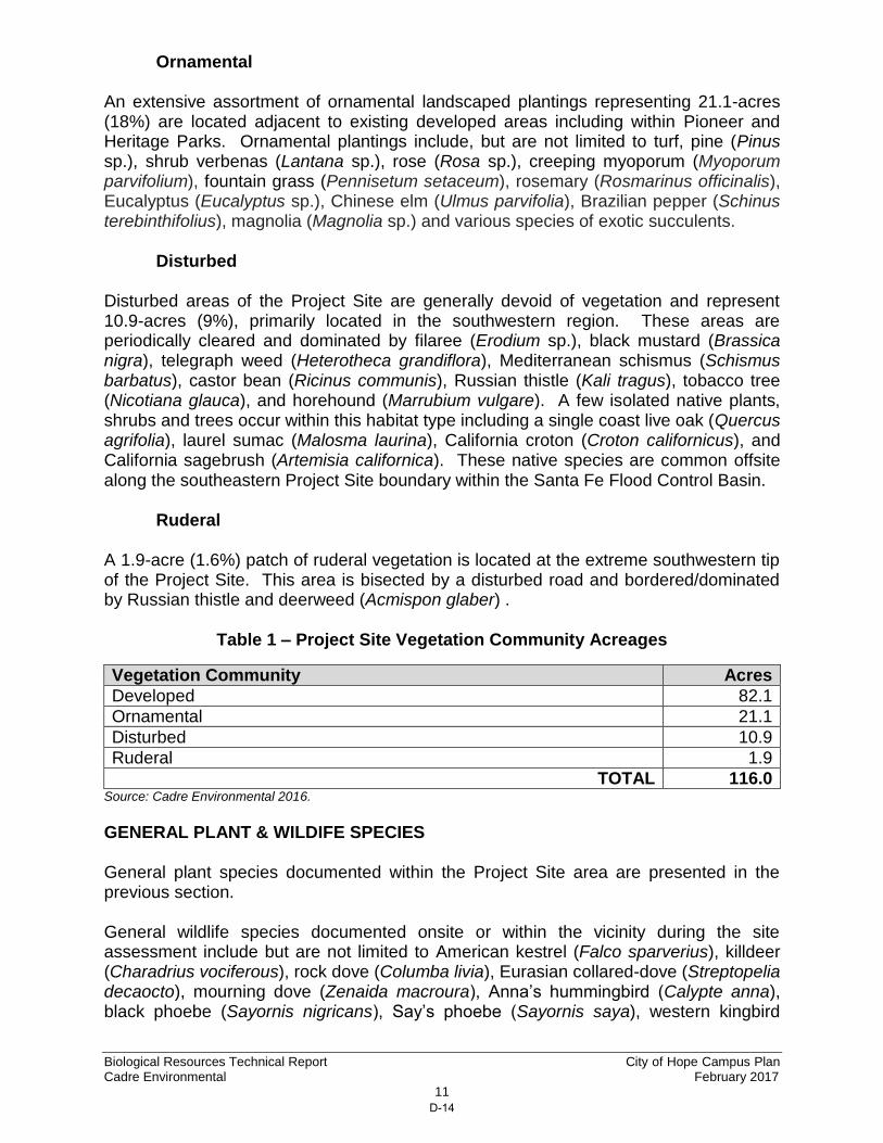
Table 1 – Project Site Vegetation Community Acreages
Vegetation Community Acres
Developed 82.1
Ornamental 21.1
Disturbed 10.9
Ruderal 1.9
TOTAL 116.0 Source: Cadre Environmental 2016.
GENERAL PLANT & WILDIFE SPECIES General plant species documented within the Project Site area are presented in the previous section. General wildlife species documented onsite or within the vicinity during the site assessment include but are not limited to American kestrel (Falco sparverius), killdeer (Charadrius vociferous), rock dove (Columba livia), Eurasian collared-dove (Streptopelia decaocto), mourning dove (Zenaida macroura), Anna’s hummingbird (Calypte anna), black phoebe (Sayornis nigricans), Say’s phoebe (Sayornis saya), western kingbird
D-14

Biological Resources Technical Report City of Hope Campus Plan Cadre Environmental February 2017
12
(Tyrannus verticalis), American crow (Corvus brachyrhynchos), northern mockingbird (Mimus polyclottos), European starling (Sturnus vulgaris), yellow-rumped warbler (Setophaga coronata), white-crowned sparrow (Zonotrichia leucophrys), house finch (Haemorhous mexicanus), house sparrow (Passer domesticus), desert cottontail (Sylvilagus audubonii), and California ground squirrel (Otospermophilus beecheyi). JURISDICTIONAL WETLAND RESOURCES No wetlands regulated by the USACE, CDFW, or RWQCB were documented within or adjacent to the Project Site. However, the unvegetated concrete lined Duarte Flood Control Channel is a jurisdictional feature and any construction improvements to the existing outfall structures would be regulated. The Duarte Flood Control Channel bisects the southwest region of the Project Site and drains south to an existing sediment basin. High flow rates extend south through a series of sediment basins and concrete lined channels which ultimately drain to Long Beach Harbor. As stated by PlaceWorks:
“The City of Hope Campus gradually slopes from northeast to southwest with elevations ranging from 482 to 435 feet. Since the site is mostly developed, the on-site drainage system utilizes inlets and a storm drain conveyance system, which carries stormwater runoff from the surface to existing outlets in the Duarte Flood Control Channel, which is owned and maintained by the Los Angeles County Flood Control District (LACFCD). The Channel runs north to south along the Campus' west property line and crosses the Campus at the southwest, under Village Road. There are two outlet connections from the Campus into the Duarte Flood Control Channel; one at the mid-point of the west property line, where a 36-inch reinforced concrete pipe (RCP) storm drain discharges, and the other at the southwest corner of the Campus, where 30-inch RCP storm drain connects to the side drain in the channel.” (PlaceWorks 2016)
SENSITIVE BIOLOGICAL RESOURCES
The following discussion describes the plant and wildlife species present, or potentially present within the property boundaries, that have been afforded special recognition by federal, state, or local resource conservation agencies and organizations, principally due to the species’ declining or limited population sizes, usually resulting from habitat loss. Also discussed are habitats that are unique, of relatively limited distribution, or of particular value to wildlife. Protected sensitive species are classified by state and/or federal resource management agencies, or both, as threatened or endangered, under provisions of the state and federal endangered species act. Vulnerable or “at-risk” species that are proposed for listing as threatened or endangered (and thereby for protected status) are categorized administratively as "candidates" by the USFWS. CDFW uses various terminology and classifications to describe vulnerable species. There are additional sensitive species classifications applicable in California. These are described below. Sensitive biological resources are habitats or individual species that have special recognition by federal, state, or local conservation agencies and organizations as endangered, threatened, or rare. The CDFW, USFWS, and special groups like the
D-15
Biological Resources Technical Report City of Hope Campus Plan Cadre Environmental February 2017
13
California Native Plant Society (CNPS) maintain watch lists of such resources. For the purpose of this assessment sources used to determine the sensitive status of biological resources are:
Plants: USFWS (2016), CDFW (2016d), CNDDB (CDFW 2016a), CNPS
(2016), and Skinner and Pavlik (1994), Wildlife: California Wildlife Habitat Relationships (2008), USFWS (2016),
CDFW (2016b, 2016e), and CNDDB (CDFW 2016a) Habitats: CNDDB (CDFW 2016a).
FEDERAL PROTECTION AND CLASSIFICATIONS The Federal Endangered Species Act of 1973 (FESA) defines an endangered species as “any species that is in danger of extinction throughout all or a significant portion of its range...” Threatened species are defined as “any species which is likely to become an endangered species within the foreseeable future throughout all or a significant portion of its range.” Under provisions of Section 9(a)(1)(B) of the FESA it is unlawful to “take” any listed species. “Take” is defined as follows in Section 3(18) of the FESA: “...harass, harm, pursue, hunt, shoot, wound, kill, trap, capture, or collect, or to attempt to engage in any such conduct.” Further, the USFWS, through regulation, has interpreted the terms “harm” and “harass” to include certain types of habitat modification as forms of a “take.” These interpretations, however, are generally considered and applied on a case-by-case basis and often vary from species to species. In a case where a property owner seeks permission from a federal agency for an action that could affect a federally listed plant and animal species, the property owner and agency are required to consult with USFWS. Section 9(a)(2)(b) of the FESA addresses the protections afforded to listed plants. Recently, the USFWS instituted changes in the listing status of former candidate species. Former C1 (candidate) species are now referred to simply as candidate species and represent the only candidates for listing. Former C2 species (for which the USFWS had insufficient evidence to warrant listing at this time) and C3 species (either extinct, no longer a valid taxon or more abundant than was formerly believed) are no longer considered as candidate species. Therefore, these species are no longer maintained in list form by the USFWS, nor are they formally protected. However, some USFWS field offices have issued memoranda stating that former C2 species are henceforth to be considered Federal Species of Concern. This term is employed in this document, but carries no official protections. All references to federally protected species in this report (whether listed, proposed for listing or candidate) include the most current published status or candidate category to which each species has been assigned by USFWS. For purposes of this assessment, the following acronyms are used for federal status species:
FE Federal Endangered
FT Federal Threatened
FPE Federal Proposed Endangered
FPT Federal Proposed Threatened
D-16

Biological Resources Technical Report City of Hope Campus Plan Cadre Environmental February 2017
14
FC Federal Candidate for Listing
The designation of critical habitat can also have a significant impact on the development of land designated as “critical habitat.” The FESA prohibits federal agencies from taking any action that will “adversely modify or destroy” critical habitat (16 U.S.C. § 1536(a)(2)). This provision of the FESA applies to the issuance of permits by federal agencies. Before approving an action affecting critical habitat, the federal agency is required to consult with the USFWS who then issues a biological opinion evaluating whether the action will “adversely modify” critical habitat. Thus, the designation of critical habitat effectively gives the USFWS extensive regulatory control over the development of land designated as critical habitat. The Migratory Bird Treaty Act of 1918 (MBTA) makes it unlawful to “take” any migratory bird or part, nest, or egg of such bird listed in wildlife protection treaties between the United States and Great Britain, the Republic of Mexico, Japan, and the Union of Soviet States. For purposes of the MBTA, “take” is defined as to pursue, hunt, capture, kill, or possess or attempt to do the same. The Bald Eagle and Golden Eagle Protection Act explicitly protects the bald eagle and golden eagle and imposes its own prohibition on any taking of these species. As defined in this act, take means to pursue, shoot, shoot at, poison, wound, kill, capture, trap, collect, or molest or disturb. Current USFWS policy is not to refer the incidental take of bald eagles for prosecution under the Bald Eagle and Golden Eagle Protection Act (16
U.S.C. 668-668d). STATE PROTECTION AND CLASSIFICATIONS California's Endangered Species Act (CESA) defines an endangered species as “...a native species or subspecies of a bird, mammal, fish, amphibian, reptile, or plant which is in serious danger of becoming extinct throughout all, or a significant portion, of its range due to one or more causes, including loss of habitat, change in habitat, overexploitation, predation, competition, or disease.” The State defines a threatened species as “...a native species or subspecies of a bird, mammal, fish, amphibian, reptile, or plant that, although not presently threatened with extinction, is likely to become an endangered species in the foreseeable future in the absence of the special protection and management efforts required by this chapter. Any animal determined by the commission as rare on or before January 1, 1985 is a threatened species.” Candidate species are defined as “...a native species or subspecies of a bird, mammal, fish, amphibian, reptile, or plant that the commission has formally noticed as being under review by the department for addition to either the list of endangered species or the list of threatened species, or a species for which the commission has published a notice of proposed regulation to add the species to either list.” Candidate species may be afforded temporary protection as though they were already listed as threatened or endangered at the discretion of the Fish and Game Commission. Unlike FESA, CESA does not include listing provisions for invertebrate species. Article 3, Sections 2080 through 2085, of CESA addresses the taking of threatened or endangered species by stating “No person shall import into this state, export out of this state, or take, possess, purchase, or sell within this state, any species, or any part or
D-17
Biological Resources Technical Report City of Hope Campus Plan Cadre Environmental February 2017
15
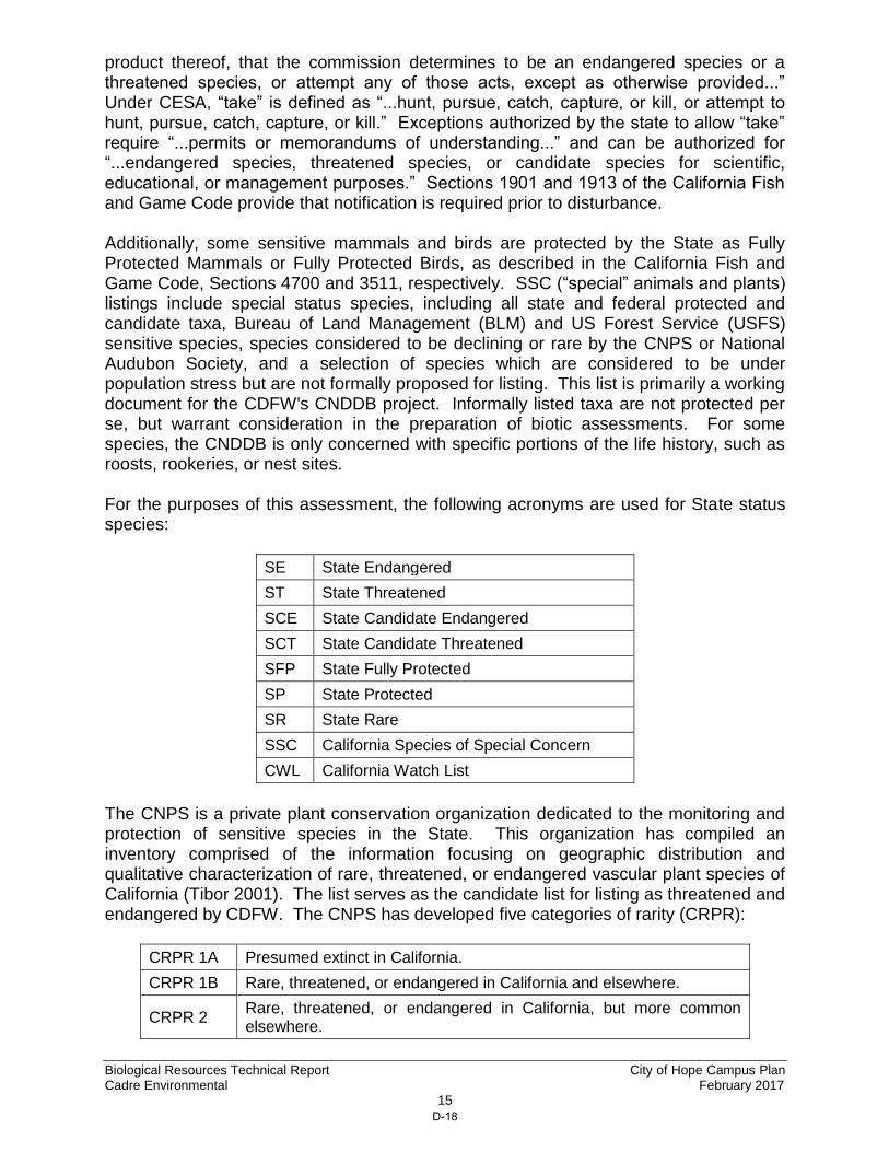
product thereof, that the commission determines to be an endangered species or a threatened species, or attempt any of those acts, except as otherwise provided...” Under CESA, “take” is defined as “...hunt, pursue, catch, capture, or kill, or attempt to hunt, pursue, catch, capture, or kill.” Exceptions authorized by the state to allow “take” require “...permits or memorandums of understanding...” and can be authorized for “...endangered species, threatened species, or candidate species for scientific, educational, or management purposes.” Sections 1901 and 1913 of the California Fish and Game Code provide that notification is required prior to disturbance. Additionally, some sensitive mammals and birds are protected by the State as Fully Protected Mammals or Fully Protected Birds, as described in the California Fish and Game Code, Sections 4700 and 3511, respectively. SSC (“special” animals and plants) listings include special status species, including all state and federal protected and candidate taxa, Bureau of Land Management (BLM) and US Forest Service (USFS) sensitive species, species considered to be declining or rare by the CNPS or National Audubon Society, and a selection of species which are considered to be under population stress but are not formally proposed for listing. This list is primarily a working document for the CDFW's CNDDB project. Informally listed taxa are not protected per se, but warrant consideration in the preparation of biotic assessments. For some species, the CNDDB is only concerned with specific portions of the life history, such as roosts, rookeries, or nest sites. For the purposes of this assessment, the following acronyms are used for State status species:
SE State Endangered
ST State Threatened
SCE State Candidate Endangered
SCT State Candidate Threatened
SFP State Fully Protected
SP State Protected
SR State Rare
SSC California Species of Special Concern
CWL California Watch List
The CNPS is a private plant conservation organization dedicated to the monitoring and protection of sensitive species in the State. This organization has compiled an inventory comprised of the information focusing on geographic distribution and qualitative characterization of rare, threatened, or endangered vascular plant species of California (Tibor 2001). The list serves as the candidate list for listing as threatened and endangered by CDFW. The CNPS has developed five categories of rarity (CRPR):
CRPR 1A Presumed extinct in California.
CRPR 1B Rare, threatened, or endangered in California and elsewhere.
CRPR 2 Rare, threatened, or endangered in California, but more common elsewhere.
D-18

Biological Resources Technical Report City of Hope Campus Plan Cadre Environmental February 2017
16
CRPR 3 Plants about which we need more information – a review list.
CRPR 4 Species of limited distribution in California (i.e., naturally rare in the wild), but whose existence does not appear to be susceptible to threat.
As stated by the CNPS:
“Threat Rank is an extension added onto the California Rare Plant Rank and designates the level of endangerment by a 1 to 3 ranking with 1 being the most endangered and 3 being the least endangered. A Threat Rank is present for all California Rare Plant Rank 1B's, 2's, 4's, and the majority of California Rare Plant Rank 3's. California Rare Plant Rank 4 plants are seldom assigned a Threat Rank of 0.1, as they generally have large enough populations to not have significant threats to their continued existence in California; however, certain conditions exist to make the plant a species of concern and hence be assigned a California Rare Plant Rank. In addition, all California Rare Plant Rank 1A (presumed extinct in California), and some California Rare Plant Rank 3 (need more information) plants, which lack threat information, do not have a Threat Rank extension.” (CNPS 2016)
0.1 Seriously threatened in California (over 80% of occurrences threatened / high degree and immediacy of threat)
0.2 Fairly threatened in California (20-80% occurrences threatened / moderate degree and immediacy of threat)
0.3 Not very threatened in California (<20% of occurrences threatened / low degree and immediacy of threat or no current threats known)
SENSITIVE HABITATS As stated by CDFW:
“One purpose of the vegetation classification is to assist in determining the level of rarity and imperilment of vegetation types. Ranking of alliances according to their degree of imperilment (as measured by rarity, trends, and threats) follows NatureServe’s Heritage Methodology, in which all alliances are listed with a G (global) and S (state) rank. For alliances with State ranks of S1-S3, all associations within them are also considered to be highly imperiled” (CDFW 2016f)
No sensitive or native habitats were documented within the Project Site. The Project Site is characterized as developed, ornamental, disturbed and ruderal. A single sensitive vegetation community (alluvial fan sage scrub, G1, S1.1) was documented immediately adjacent and offsite along the southeastern Project Site boundary. Also referred to as Riversidean alluvial fan sage scrub, this vegetation community extends southeast of the Project Site within the Santa Fe Flood Control Basin. The narrow strip which occurs between the Project Site and existing access
D-19

Biological Resources Technical Report City of Hope Campus Plan Cadre Environmental February 2017
17
road/dike is dominated by scale-broom (Lepidospartum squamatum), California sagebrush, laurel sumac, California buckwheat (Eriogonum fasciculatum), California bush sunflower (Encelia californica), brittlebush (Encelia farinosa), and Ladies’ tobacco (Pseudognaphalium californicum). SENSITIVE PLANTS The Project Site was assessed to determine the potential for ten (10) sensitive plant species known to occur within the region, to occur onsite, as presented in Table 2, Sensitive Plant Species Assessment. No suitable habitat for sensitive plant species including those listed as federal or state threatened/endangered was documented within the Project Site. No sensitive plant species listed in Table 2 or native habitats were documented within the Project Site. The Project Site is characterized as developed, ornamental, disturbed and ruderal.
Table 2. Sensitive Plant Species Assessment
Species Name (Scientific Name) Status
Habitat Description Comments
Braunton’s milk-vetch (Astragalus brauntonii) CRPR 1B.1 FE
Perennial herb which generally blooms from January to August within chaparral, coastal sage scrub and grassland habitats with recently burned/disturbed openings. (CNPS 2016).
Not expected to occur onsite based on a lack of suitable habitat.
Plummer’s mariposa-lily (Calochortus plummerae) CRPR 4.2
Perennial bulbiferous herb which generally blooms from May to June within chaparral, cismontane woodland, coastal scrub, lower montane coniferous forest, and grassland habitats with granite and rocky substrates. (CNPS 2016)
Not expected to occur onsite based on a lack of suitable habitat.
Parry’s spineflower (Chorizanthe parryi var. parryi) CRPR 1B.1
Annual herb which generally blooms from April to June within chaparral, cismontane woodland, coastal scrub and grassland habitats with sandy and/or rocky openings. (CNPS 2016)
Not expected to occur onsite based on a lack of suitable habitat.
California saw-grass (Cladium californicum) CRPR 2B.2
Perennial rhizomatous herb which generally blooms from June to September within meadows, seeps, marshes and swamps in both alkaline and freshwater. (CNPS 2016)
Not expected to occur onsite based on a lack of suitable habitat.
D-20
Biological Resources Technical Report City of Hope Campus Plan Cadre Environmental February 2017
18
Species Name (Scientific Name) Status
Habitat Description Comments
Slender-horned spineflower (Dodecahema leptoceras) CRPR 1B.1 FE/SE
Annual herb which generally blooms from April to June within chaparral, cismontane woodland and coastal scrub (alluvial fan) with sandy substrates. (CNPS 2016)
Not expected to occur onsite based on a lack of suitable habitat.
San Gabriel bedstraw (Galium grande) CRPR 1B.2
Perennial deciduous shrub which generally blooms from January to July within broad-leafed upland forest, chaparral, cismontane woodland and lower montane coniferous forest habitats. (CNPS 2016)
Not expected to occur onsite based on a lack of suitable habitat.
Mesa horkelia (Horkelia cuneata ssp. puberula) CRPR 1B.1
Perennial herb which generally blooms from February to September within chaparral (maritime), cismontane woodland and coastal scrub with sandy or gravelly substrates. (CNPS 2016)
Not expected to occur onsite based on a lack of suitable habitat.
Robinson’s pepper-grass (Lepidium virginicum var. robinsonii) CRPR 4.3
Annual herb which generally blooms from January to July within chaparral and coastal sage scrub habitats. (CNPS 2016)
Not expected to occur onsite based on a lack of suitable habitat.
Brand’s star phacelia (Phacelia stellaris) CRPR 1B.1 FC
Annual herb which generally blooms from March to June within coastal dunes and coastal scrub habitats. (CNPS 2016)
Not expected to occur onsite based on a lack of suitable habitat.
Greata’s aster (Symphyotrichum greatae) CRPR 1B.3
Perennial rhizomatous herb which generally blooms from June to October within broad-leaved upland forest, chaparral, cismontane woodland, lower montane coniferous forest and riparian woodland habitats.
Not expected to occur onsite based on a lack of suitable habitat.
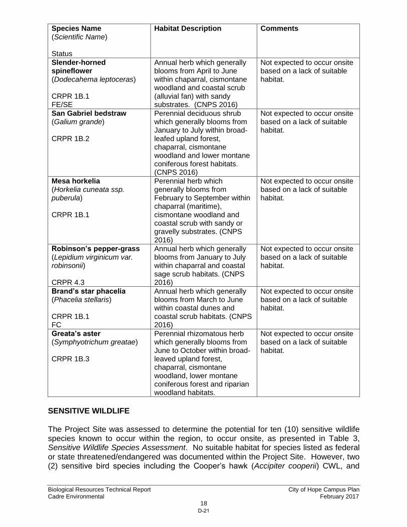
SENSITIVE WILDLIFE The Project Site was assessed to determine the potential for ten (10) sensitive wildlife species known to occur within the region, to occur onsite, as presented in Table 3, Sensitive Wildlife Species Assessment. No suitable habitat for species listed as federal or state threatened/endangered was documented within the Project Site. However, two (2) sensitive bird species including the Cooper’s hawk (Accipiter cooperii) CWL, and
D-21

Biological Resources Technical Report City of Hope Campus Plan Cadre Environmental February 2017
19
white-tailed kite (Elanus leucurus) SFP may occasionally roost and forage onsite, as presented in Table 3, Sensitive Wildlife Species Assessment. No sensitive wildlife species or native habitats were documented within the Project Site. The Project Site is characterized as developed, ornamental, disturbed and ruderal.
Table 3. Sensitive Wildlife Species Assessment Species Name (Scientific Name) Status
Habitat Description Comments
REPTILES
Coast horned lizard (Phrynosoma blainvillii) SSC
The horned lizard occurs primarily in scrub, chaparral, and grassland habitats.
Not expected to occur onsite based on a lack of suitable habitat.
BIRDS
Coastal California gnatcatcher (Polioptila californica californica)
FT/SSC
The coastal California gnatcatcher is a non-migratory bird species that primarily occurs within sage scrub habitats in coastal southern California dominated by California sagebrush and California buckwheat.
Not expected to occur onsite based on a lack of suitable habitat. Closest record north of I-215 and east of I-605 (Figure 6, USFWS Sensitive Species Occurrences)
Cooper's hawk (Accipiter cooperii)
SSC
Cooper’s hawk is most commonly found within or adjacent to riparian/oak forest and woodland habitats. This uncommon resident of California increases in numbers during winter migration.
Not expected to breed onsite based on a lack of suitable habitat. The species may occasionally forage onsite. However, these occurrences are expected to be low based on the lack of suitable habitat adjacent to the Project Site.
Least Bell's vireo (Vireo bellii pusillus)
FE/SE
Least Bell’s vireo reside in riparian habitats with a well-defined understory including southern willow scrub, mulefat, and riparian forest/woodland habitats.
Not expected to occur onsite based on a lack of suitable habitat. Documented in the Santa Fe Dam Recreational Area east of I-605. (Figure 6, USFWS Sensitive Species Occurrences)
D-22
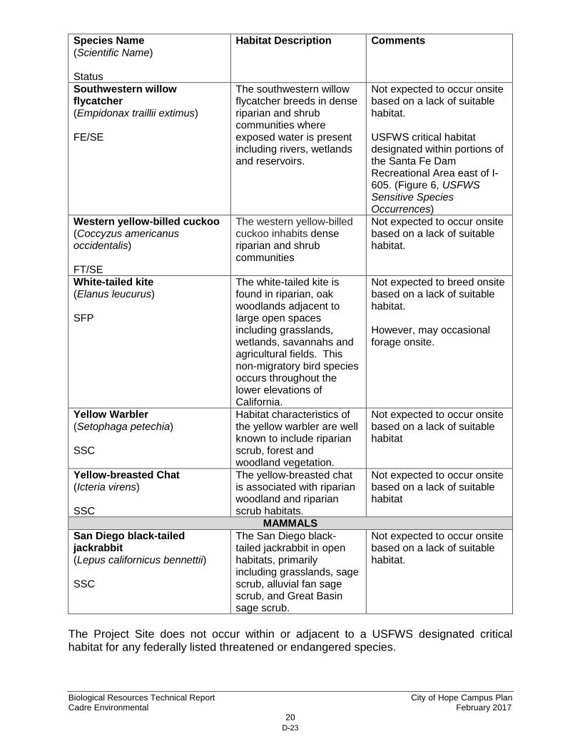
Biological Resources Technical Report City of Hope Campus Plan Cadre Environmental February 2017
20
Species Name (Scientific Name) Status
Habitat Description Comments
Southwestern willow flycatcher (Empidonax traillii extimus)
FE/SE
The southwestern willow flycatcher breeds in dense riparian and shrub communities where exposed water is present including rivers, wetlands and reservoirs.
Not expected to occur onsite based on a lack of suitable habitat. USFWS critical habitat designated within portions of the Santa Fe Dam Recreational Area east of I-605. (Figure 6, USFWS Sensitive Species Occurrences)
Western yellow-billed cuckoo (Coccyzus americanus occidentalis) FT/SE
The western yellow-billed cuckoo inhabits dense riparian and shrub communities
Not expected to occur onsite based on a lack of suitable habitat.
White-tailed kite (Elanus leucurus)
SFP
The white-tailed kite is found in riparian, oak woodlands adjacent to large open spaces including grasslands, wetlands, savannahs and agricultural fields. This non-migratory bird species occurs throughout the lower elevations of California.
Not expected to breed onsite based on a lack of suitable habitat. However, may occasional forage onsite.
Yellow Warbler (Setophaga petechia)
SSC
Habitat characteristics of the yellow warbler are well known to include riparian scrub, forest and woodland vegetation.
Not expected to occur onsite based on a lack of suitable habitat
Yellow-breasted Chat (Icteria virens) SSC
The yellow-breasted chat is associated with riparian woodland and riparian scrub habitats.
Not expected to occur onsite based on a lack of suitable habitat
MAMMALS
San Diego black-tailed jackrabbit (Lepus californicus bennettii) SSC
The San Diego black-tailed jackrabbit in open habitats, primarily including grasslands, sage scrub, alluvial fan sage scrub, and Great Basin sage scrub.
Not expected to occur onsite based on a lack of suitable habitat.
The Project Site does not occur within or adjacent to a USFWS designated critical habitat for any federally listed threatened or endangered species.
D-23

1 inch = 500 ft.
Figure 6 - USFWS Sensitive Species Occurrences Biological Resources Technical Report
City of Hope Campus Plan
CADREEnvironmental
City of DuarteCity of Duarte
City of IrwindaleCity of Irwindale
Duarte Road
Buen
a Vi
sta
Stre
et
PROJECTSITE
PROJECTSITE
FOOTHILL FREEWAY
SAN GABRIEL RIV
ER FREEWAY
§̈¦210
§̈¦605
§̈¦605
Santa FeFlood Control
Basin
Santa FeFlood Control
Basin
Santa Fe DamRecreational Area
Santa Fe DamRecreational Area
City of Monrovia
City of Bradbury
City of Baldwin Park
City of Monrovia
City of Bradbury
City of Baldwin Park
USFWS Designated Critical HabitatSouthwestern Willow Flycatcher
USFWS Designated Critical HabitatSouthwestern Willow Flycatcher
Source: USFWS Species Occurrence Database. Updated Nov 2015
Least Bell’s Vireo FE/SE
Coastal California Gnatcatcher FT
§̈¦210
D-24
Biological Resources Technical Report City of Hope Campus Plan Cadre Environmental February 2017
22
JURISDICTIONAL WETLAND RESOURCES No wetlands regulated by the USACE, CDFW, or RWQCB were documented within or adjacent to the Project Site. However, the unvegetated concrete lined Duarte Flood Control Channel is a jurisdictional feature and any impacts to the existing outfall structures would be regulated. The Duarte Flood Control Channel bisects the southwest region of the Project Site and drains south to an existing sediment basin. High flow rates extend south through a series of sediment basins and concrete lined channels which drain to Long Beach Harbor.
ENVIRONMENTAL IMPACTS
The following section includes an analysis of the direct and/or indirect impacts of the proposed action on sensitive biological resources. This analysis characterizes the project related activities that are anticipated to adversely impact the species, and when feasible, quantifies such impacts. Direct effects are defined as actions that may cause an immediate effect on the species or its habitat, including the effects of interrelated actions and interdependent actions. Indirect effects are caused by or result from the proposed actions, are later in time, and are reasonably certain to occur. Indirect effects may occur outside of the area directly affected by the proposed action. THRESHOLD OF SIGNIFICANCE The environmental impacts relative to biological resources are assessed using impact significance criteria which mirror the policy statement contained in the CEQA at Section 21001 (c) of the Public Resources Code. This section reflects that the legislature has established it to be the policy of the state to:
“Prevent the elimination of fish and wildlife species due to man’s activities, ensure that fish and wildlife populations do not drop below self-perpetuating levels, and preserve for future generations representations of all plant and animal communities…”
The following definitions apply to the significance criteria for biological resources:
“Endangered” means that the species is listed as endangered under state or federal law.
“Threatened” means that the species is listed as threatened under state or federal law.
“Rare” means that the species exists in such small numbers throughout all or a significant portion of its range that it may become endangered if its environment worsens.
“Region” refers to the area within southern California that is within the range of the individual species.
D-25
Biological Resources Technical Report City of Hope Campus Plan Cadre Environmental February 2017
23
“Sensitive habitat” refers to habitat for plants and animals (1) which plays a special role in perpetuating species utilizing the habitat on the property, and (2) without which there would be substantial danger that the population of that species would drop below self-perpetuating levels.
“Substantial effect” means significance loss or harm of a magnitude which, based on current scientific data and knowledge, (1) would cause a species or a native plant or animal community to drop below self-perpetuating levels on a statewide or regional basis or (2) would cause a species to become threatened or endangered.
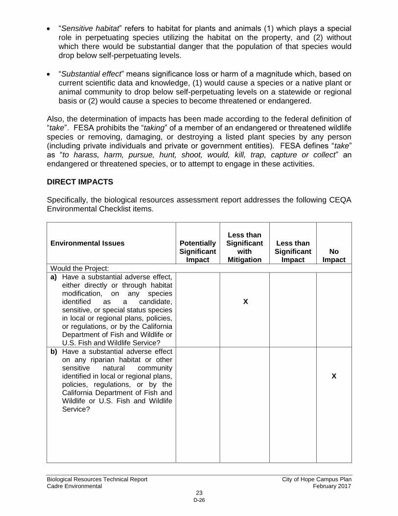
Also, the determination of impacts has been made according to the federal definition of “take”. FESA prohibits the “taking” of a member of an endangered or threatened wildlife species or removing, damaging, or destroying a listed plant species by any person (including private individuals and private or government entities). FESA defines “take” as “to harass, harm, pursue, hunt, shoot, would, kill, trap, capture or collect” an endangered or threatened species, or to attempt to engage in these activities. DIRECT IMPACTS Specifically, the biological resources assessment report addresses the following CEQA Environmental Checklist items. Environmental Issues
Potentially Significant
Impact
Less than Significant
with Mitigation
Less than Significant
Impact
No Impact
Would the Project:
a) Have a substantial adverse effect, either directly or through habitat modification, on any species identified as a candidate, sensitive, or special status species in local or regional plans, policies, or regulations, or by the California Department of Fish and Wildlife or U.S. Fish and Wildlife Service?
X
b) Have a substantial adverse effect on any riparian habitat or other sensitive natural community identified in local or regional plans, policies, regulations, or by the California Department of Fish and Wildlife or U.S. Fish and Wildlife Service?
X
D-26
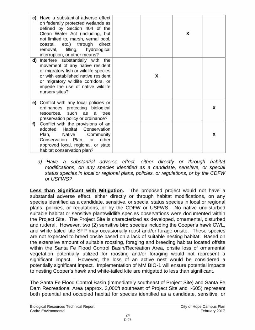
Biological Resources Technical Report City of Hope Campus Plan Cadre Environmental February 2017
24
c) Have a substantial adverse effect on federally protected wetlands as defined by Section 404 of the Clean Water Act (including, but not limited to, marsh, vernal pool, coastal, etc.) through direct removal, filling, hydrological interruption, or other means?
X
d) Interfere substantially with the movement of any native resident or migratory fish or wildlife species or with established native resident or migratory wildlife corridors, or impede the use of native wildlife nursery sites?
X
e) Conflict with any local policies or ordinances protecting biological resources, such as a tree preservation policy or ordinance?
X
f) Conflict with the provisions of an adopted Habitat Conservation Plan, Native Community Conservation Plan, or other approved local, regional, or state habitat conservation plan?
X
a) Have a substantial adverse effect, either directly or through habitat
modifications, on any species identified as a candidate, sensitive, or special status species in local or regional plans, policies, or regulations, or by the CDFW or USFWS?
Less than Significant with Mitigation. The proposed project would not have a substantial adverse effect, either directly or through habitat modifications, on any species identified as a candidate, sensitive, or special status species in local or regional plans, policies, or regulations, or by the CDFW or USFWS. No native undisturbed suitable habitat or sensitive plant/wildlife species observations were documented within the Project Site. The Project Site is characterized as developed, ornamental, disturbed and ruderal. However, two (2) sensitive bird species including the Cooper’s hawk CWL, and white-tailed kite SFP may occasionally roost and/or forage onsite. These species are not expected to breed onsite based on a lack of suitable nesting habitat. Based on the extensive amount of suitable roosting, foraging and breeding habitat located offsite within the Santa Fe Flood Control Basin/Recreation Area, onsite loss of ornamental vegetation potentially utilized for roosting and/or foraging would not represent a significant impact. However, the loss of an active nest would be considered a potentially significant impact. Implementation of MM BIO-1 will ensure potential impacts to nesting Cooper’s hawk and white-tailed kite are mitigated to less than significant. The Santa Fe Flood Control Basin (immediately southeast of Project Site) and Santa Fe Dam Recreational Area (approx. 3,000ft southeast of Project Site and I-605) represent both potential and occupied habitat for species identified as a candidate, sensitive, or
D-27

Biological Resources Technical Report City of Hope Campus Plan Cadre Environmental February 2017
25
special status species in local or regional plans, policies, or regulations, or by the CDFW or USFWS. Specifically, the federal/state endangered least Bell’s vireo and federal threatened coastal California gnatcatcher have been documented within the Santa Fe Dam Recreational Area, as illustrated in Figure 6, USFWS Sensitive Species Occurrences. These offsite regions located southeast of I-605 will not be directly impacted as a result of the proposed project. Therefore, no mitigation is required.
b) Have a substantial adverse effect on any riparian habitat or other sensitive natural community identified in local or regional plans, policies, regulations, or by CDFW or USFWS?
No Impact. No riparian, sensitive or native habitats were documented within the Project Site as outlined in Table 4, Project Site Vegetation Community Potential Temporary/Permanent Impacts. The Project Site is characterized as developed, ornamental, disturbed and ruderal. Although a single sensitive vegetation community (alluvial fan sage scrub, G1, S1.1) was documented immediately adjacent and offsite along the southeastern Project Site boundary, this vegetation community will not be directly impacted by implementation of the proposed specific plan. Therefore, no mitigation is required.
Table 4 – Project Site Vegetation Community Temporary/Permanent Impacts
Vegetation Community Acres Potential Temporary/Permanent
Impact Acres
Developed 82.1 82.1
Ornamental 21.1 21.1
Disturbed 10.9 10.9
Ruderal 1.9 1.9
TOTAL 116.0 116.0 Source: Cadre Environmental 2016.
c) Have a substantial adverse effect on federally protected wetlands as defined by
Section 404 of the CWA (including, but not limited to, marsh, vernal pool, coastal, etc.) through direct removal, filling, hydrological interruption, or other means?
Less than Significant Impact. No wetlands regulated by the USACE, CDFW, or RWQCB were documented within or adjacent to the Project Site. However, the unvegetated concrete lined Duarte Flood Control Channel is a jurisdictional feature and any impacts to the existing outfall structures would be regulated. The Duarte Flood Control Channel bisects the southwest region of the Project Site and drains south to an existing currently unvegetated sediment basin. High flow rates extend south through a series of sediment basins and concrete lined channels which ultimately drain to Long Beach Harbor. In the event any phase of the proposed project will require the construction, improvements or relocation of existing outfall structures leading to the Duarte Flood Control Channel or Santa Fe Flood Control Basin, the project applicant will conduct a formal jurisdictional delineation and obtain all applicable permits including a 404/408 Permit from the USACE, 1602 SAA from CDFW, and a 401 Certification issued by the RWQCB pursuant to the California Water Code Section 13260, as
D-28

Biological Resources Technical Report City of Hope Campus Plan Cadre Environmental February 2017
26
warranted. Compliance with the federal and state regulatory requirements will reduce potential impacts to jurisdictional resources to less than significant.
d) Interfere substantially with the movement of any native resident or migratory fish or wildlife species or with established native resident or migratory wildlife corridors, or impede the use of native wildlife nursery sites?
Less than Significant with Mitigation. The Project Site is largely developed and surrounded by urbanized uses and does not represent a wildlife movement corridor or route between open space habitats. However, the non-native ornamental vegetation, trees and shrubs within the Project Site including adjacent habitats are expected to provide nesting habitat for raptors and migratory birds protected under the federal MBTA. As stated by PlaceWorks:
“Construction activities of future development, revitalization, and/or redevelopment activities that would be accommodated by the Specific Plan could result in the removal and/or replacement of trees onsite. However, the Specific Plan intends to preserve and enhance the existing trees in its parks and open space areas. Furthermore, future development would also be required to comply with the Migratory Bird Treaty Act (MBTA) (US Code, Title 16, §§ 703–712) and state law (California Fish and Game Code, §§ 3503 et seq.).” (PlaceWorks 2016)
Loss of an active nest would be considered a potentially significant impact. Implementation of MM BIO-1 will ensure compliance with the MBTA and reduce potential impacts to nesting birds to less than significant.
e) Conflict with any local policies or ordinances protecting biological resources, such as a tree preservation policy or ordinance?
No Impact. As stated by PlaceWorks:
“The project site includes a number of mature trees scattered throughout the project site, including trees fronting onto Duarte Street (see Figures 3, Aerial Photograph). Future development within the project site that would be accommodated by the Specific Plan may involve the removal or replacement of trees in certain areas of the project site. The cities of Duarte and Irwindale do not have any local tree ordinances protecting trees within the project site. The City of Duarte Municipal Code protects street trees (trees within the City’s public right-of-way and jurisdiction) under Chapter 13.08, however, street trees would not be impacted by development in the Specific Plan area. Additionally, the Specific Plan would outline standards and guidelines to ensure the proper management (e.g., planting, health, maintenance) of trees throughout the project site. Therefore, implementation of the project would not conflict with local polices or ordinances protecting street trees, and no impact would occur. This topic will not be evaluated further in the EIR, and no mitigation measures are necessary.” (PlaceWorks 2016)
D-29

Biological Resources Technical Report City of Hope Campus Plan Cadre Environmental February 2017
27
f) Conflict with the provisions of an adopted Habitat Conservation Plan, Native Community Conservation Plan, or other approved local, regional, or state habitat conservation plan?
No Impact. As stated by PlaceWorks:
“There is no habitat conservation plan, natural community conservation plan, or other approved local, regional, or state habitat conservation plan in the cities of Duarte or Irwindale. Therefore, implementation of the project would not result in a conflict with the provisions of an adopted habitat conservation plan and no impact would occur. This topic will not be evaluated further in the EIR, and no mitigation measures are necessary.” (PlaceWorks 2016)
INDIRECT IMPACTS Potential indirect impacts include hydrological modification, discharges, lighting, and construction noise. Compliance with all the following guidelines will ensure that the proposed project will not result in significant indirect impacts to habitats and associated floral and faunal species within and/or adjacent to the Project Site.
Water Quality/Hydrology
Impacts to hydrology and water quality would be less than significant during both construction and operation (i.e., compliance with NPDES permit and MS4 code provisions would ensure no impacts to species, and compliance with County MS4 permit requirements and LID manual would also ensure no impacts to species). As stated by PlaceWorks:
“The Specific Plan area is required to comply with the stormwater and urban runoff pollution control provisions of the Los Angeles Regional Water Quality Control Board’s National Pollution Discharge Elimination System (NPDES) permit for municipal separate storm sewer system (MS4) discharges, which are incorporated into the Duarte and Irwindale Municipal Codes (Chapter 6.15 of the City of Duarte Municipal Code, and Chapter 8.28 of the City of Irwindale Municipal Code.) The MS4 NPDES and Duarte and Irwindale Code provisions regulate non-stormwater discharge to the storm drain system and reduction of pollutants in stormwater and urban runoff to the maximum extent practicable.” (PlaceWorks 2016)
Toxics
Toxic sources within the Project Site would be limited to those commonly associated with residential developments such as pesticides, insecticides, herbicides, fertilizers, and vehicle emissions. In order to mitigate for the potential effects of these toxics, the project will incorporate structural BMPs, as required in association with compliance with the NPDES permit system, in order to reduce the level of toxins introduced into the
D-30
Biological Resources Technical Report City of Hope Campus Plan Cadre Environmental February 2017
28
drainage system. Water quality measures will be implemented and no significant impacts are anticipated.
Lighting Impacts related to lighting would be less than significant during both construction and operation. Night lighting associated with the proposed project would not be directed toward the Santa Fe Flood Control Basin located immediately southeast of the Project Site and no indirect impacts to wildlife species will occur. No significant impacts are anticipated.
Noise
Indirect temporal noise impacts may occur to nesting bird species located adjacent to the Project Site (Santa Fe Flood Control Basin) during project construction. Noise and vibration associated with the use of heavy equipment during project construction has the potential to disrupt bird nesting, foraging and breeding behavior within the adjacent sensitive receptor site. Biological Mitigation Measure BIO-MM1 and BIO-MM2, have been incorporated into the project to collectively contribute to reducing potential indirect noise impacts to bird species located within or adjacent to the Project Site to the level of less than significance.
No significant impacts are anticipated. CUMULATIVE IMPACTS The temporary direct and/or indirect impacts of the project would not result in significant cumulative impacts (CEQA Section 15310) to environmental resources within the region of the Project Site. Cumulative impacts refer to incremental effects of an individual project when assessed with the effects of past, current, and proposed projects. The project represents the enhancement (redevelopment) and development of previously disturbed habitats within its approximately 116-acre existing campus and therefore will not result in an adverse cumulative impact.
MITIGATION MEASURES
The following biological mitigation measures address those adverse impacts determined to be potentially significant, or are relevant to the protection of biological resources to the extent practicable as part of ensuring all potential impacts are mitigated to a level of less than significant. BIO-MM1 Federal Migratory Bird Treaty Act Mitigation for potential direct/indirect impacts to common and sensitive passerine and raptor species will require compliance with the federal MBTA. Construction outside the nesting season (between September 1st and February 15th) does not require pre-removal nesting bird surveys. If construction is proposed between February 16th and August 31st, a qualified biologist must conduct a nesting bird survey(s) no more than
D-31
Biological Resources Technical Report City of Hope Campus Plan Cadre Environmental February 2017
29
three (3) days prior to initiation of grading to document the presence or absence of nesting birds within or directly adjacent (100 feet) to the Project Site. The preconstruction survey(s) will focus on identifying any raptors and/or passerines nests that may be directly or indirectly affected by construction activities. If active nests are documented, species-specific measures shall be prepared by a qualified biologist and implemented to prevent abandonment of the active nest. At a minimum, grading in the vicinity of a nest shall be postponed until the young birds have fledged. A minimum exclusion buffer of 100 feet shall be maintained during construction, depending on the species and location. The perimeter of the nest setback zone shall be fenced or adequately demarcated with stakes and flagging at 20-foot intervals, and construction personnel and activities restricted from the area. A survey report by a qualified biologist verifying that no active nests are present, or that the young have fledged, shall be submitted to the City of Duarte prior to initiation of grading in the nest-setback zone. The qualified biologist shall serve as a biological monitor during those periods when construction activities occur near active nest areas to ensure that no inadvertent impacts on these nests occur. A final report of the findings, prepared by a qualified biologist, shall be submitted to the City of Duarte prior to construction-related activities that have the potential to disturb any active nests during the nesting season. Any nest permanently vacated for the season would not warrant protection pursuant to the MBTA. BIO-MM2 Indirect Noise Impacts Short-term construction-related noise impacts will be reduced by the implementation of the following BMP’s:
During all Project Site excavation, grading, and construction, the contractors shall equip all construction equipment, fixed or mobile, with properly operating and maintained mufflers, consistent with manufacturers’ standards. The construction contractor shall place all stationary construction equipment so that emitted noise is directed away from sensitive receptors nearest the Project Site (Santa Fe Flood Control Basin).
The construction contractor shall locate equipment staging in areas that will create the greatest distance between construction-related noise sources and noise sensitive receptors nearest the Project Site during all project construction.
The construction contractor shall limit all construction-related activities that would result in high noise levels according to the construction hours to be determined by City staff.
Implementation of Mitigation Measures BIO-MM1 and BIO-MM2 would reduce all potential significant unavoidable impacts on biological resources below a level of significance.
D-32
Biological Resources Technical Report City of Hope Campus Plan Cadre Environmental February 2017
30
LITERATURE CITED
American Ornithologist Union (AOU). 1998. Check-list of North American Birds. 7th
ed. American Ornithologists’ Union, Washington, DC. Baker, R. J., L. C. Bradley, R. D. Bradley, J. W. Dragoo, M. D. Engstrom, R. S.
Hoffman, C. A. Jones, F. Reid, D. W. Rice, and C. Jones. 2003. Revised checklist of North American mammals north of Mexico. Occasional Papers of the Museum of Texas Tech University. No. 229: 1-23.
California Department of Fish and Wildlife (CDFW), Natural Diversity Data Base (CNDDB).
2016a. Sensitive Element Record Search for the Baldwin Park and Azusa Quadrangles. California Department of Fish and Wildlife. Sacramento, California. Accessed February 2016.
California Department of Fish and Wildlife (CDFW). 2016b. Special Animals. Natural
Heritage Division, Natural Diversity Data Base. California Department of Fish and Wildlife (CDFW). 2016c. Special Vascular Plants,
Bryophytes, and Lichens. Natural Heritage Division, Natural Diversity Data Base.
California Department of Fish and Wildlife (CDFW). 2016d. Endangered, Threatened,
and Rare Plants of California. Natural Heritage Division, Natural Diversity Data Base.
California Department of Fish and Wildlife (CDFW). 2016e. State and Federally Listed
Endangered and Threatened Animals of California. Natural Heritage Division, Natural Diversity Data Base.
California Department of Fish and Wildlife (CDFW) 2016f.
http://www.dfg.ca.gov/biogeodata/vegcamp/natural_comm_background.asp. California Native Plant Society. 2016. http://cnps.org/ Environmental Laboratory. 1987. Corps of Engineers Wetlands Delineation Manual,
Technical Report Y-87-1, U.S. Army Engineer Waterways Experimental Station, Vicksburg, Mississippi.
Hickman, J. C. 1993. The Jepson Manual: Higher Plants of California. Berkeley:
University of California Press. Holland, R.F. 1986. Preliminary Descriptions of the Terrestrial Natural Communities of
California. State of California Resources Agency. Department of Fish and Game. Non-Game Heritage Program. Sacramento, CA.
North American Herpetology. 2016. http://www.cnah.org/ Accessed February 2016.
D-33

Biological Resources Technical Report City of Hope Campus Plan Cadre Environmental February 2017
31
PlaceWorks. 2015. Initial Study – City of Hope Campus Plan, City of Duarte. Skinner, M. W. and B. M. Pavlik. 1994. California Native Plant Society's Inventory of
Rare and Endangered Vascular Plants of California. California Native Plant Society. Special Publication, no. 1, 5th ed. Sacramento, California.
Tibor, D. [ed.]. 2001. California Native Plant Society. Inventory of Rare and
Endangered Plants of California. California Native Plant Society, Special Publication Number 1, Sixth Edition.
U.S. Army Corps of Engineers, Engineer Research and Development Center (ERDC).
September 2008. Regional Supplement to the Corps of Engineers Wetland Delineation Manual: Arid West Region (Version 2.0).
U.S. Army Corps of Engineers. 2014. 2014 National Wetland Plant List.
http://rsgisias.crrel.usace.army.mil/NWPL/. Accessed January 2016. U.S. Fish and Wildlife Service (USFWS). November 2015. Threatened and
Endangered Species Occurrence Database. Pacific Southwest Region. Carlsbad Office. Accessed February 2016.
Certification “I hereby certify that the statements furnished above and in the attached exhibits present the data and information required for this biological evaluation, and that the facts, statements, and information presented are true and correct to the best of my knowledge”.
Author:___________________________________________Date: February 7th, 2017
D-34