appendix 5 ecological impact assessment report
TRANSCRIPT

IRIS Cable System 59 March 2021 Job No. 1334
Appendix 5 – Ecological Impact Assessment Report.

Ecological Impact Assessment (EcIA) for a Foreshore Licence
Application for main lay for a marine fibre optic cable with a landfall
at Ballyloughane Strand, Galway Bay.
5th March 2021
Prepared by: (MCIEEM) of Altemar Ltd.
On behalf of: Farice ehf (Ltd.) and Deep Sea Fibre Networks
Altemar Ltd., 50 Templecarrig Upper, Delgany, Co. Wicklow. 00-353-1-2010713. [email protected]
Directors:
Company No.427560 VAT No. 9649832U
www.altemar.ie

Document Control Sheet
Client Farice ehf (Ltd.) and Deep Sea Fibre Networks
Project Ecological Impact Assessment (EcIA) for a Foreshore Licence Application for main lay for a marine fibre optic cable with a landfall at Ballyloughane Strand, Galway Bay.
Report Ecological Impact Assessment
Date 5th March 2021
Project No: Document Reference:
Version Author Reviewed Date
Draft 01 5th March 2021
Draft 02 5th March 2021

Table of Contents Introduction ..................................................................................................................................................... 1
Background ................................................................................................................................................... 1
Study Objectives ........................................................................................................................................... 1
Altemar Ltd. .................................................................................................................................................. 1
Project Description ........................................................................................................................................... 2
Ecological Assessment Methodology............................................................................................................... 10
Desk Study .................................................................................................................................................. 10
Field Survey ................................................................................................................................................ 10
Consultation ............................................................................................................................................... 10
Spatial Scope and Zone of Influence ............................................................................................................ 11
Ecological Evaluation Criteria ...................................................................................................................... 11
Results ............................................................................................................................................................ 13
Proximity to Designated Conservation Sites ................................................................................................ 13
Habitats and Species – On-Site Fieldwork .................................................................................................... 25
Potential Impacts ........................................................................................................................................ 41
Construction Impacts .............................................................................................................................. 41
Mitigation Measures & Monitoring ............................................................................................................. 49
Cumulative Impacts .................................................................................................................................... 54
Residual Impacts and Conclusion .................................................................................................................... 55
References ...................................................................................................................................................... 56
Appendix I. Environmental Characteristics of Repeater and PSBU Housing Material. ....................................... 58

1
Introduction
Background Ecological Impact Assessment (EcIA) has been defined as ‘the process of identifying, quantifying and evaluating
the potential impacts of defined actions on ecosystems or their components (Treweek, 1999). EcIA is a key
component of Environmental Impact Assessments (EIAs), which are carried out to meet the requirements of
Council Directive 85/337/EEC on the Assessment of the effects of certain public and private projects on the
environment(CEC, 1985), as amended by Council Directive 97/11/EC (CEC, 1997). The purpose of EcIA is to
provide decision-makers with clear and concise information about the likely ecological effects associated with
a project and their significance both directly and in a wider context. Protecting and enhancing biodiversity and
landscapes and maintaining natural processes depends upon input from ecologists and other specialists at all
stages in the decision-making and planning process; from the early design of a project through implementation
to its decommissioning (IEEM, 2018). The following EcIA has been prepared at the request of the National Parks
and Wildlife Service (NPWS) for a proposed Deep Sea Fibre Networks Ltd. fibre optic cable from Iceland to the
west coast of Ireland at Ballyloughane Strand, Galway Bay.
Study Objectives The objectives of this EcIA are to:
1. Outline the project and any alternatives assessed;
2. Undertake a baseline ecological feature, resource and function assessment of the site and zone of
influence;
3. Assess and define significance of the direct, indirect and cumulative ecological impacts of the project
during its construction, lifetime and decommissioning stages;
4. Refine, where necessary, the project and propose mitigation measures to remove or reduce impacts
through sustainable design and ecological planning; and
5. Suggest monitoring measures to follow up the implementation and success of mitigation measures and
ecological outcomes.
The following guidelines have been used in preparation of this EcIA:
Guidelines on the information to be contained in Environmental Impact Statements (EPA, 2002);
Advice Notes on current practice in the preparation of EIS’s (EPA, 2003);
Institute of Ecology and Environmental Management Guidelines for EIA (IEEM, 2005).
Guidelines for Ecological Impact Assessment in the UK and Ireland (2018) which combines the
Guidelines for Ecological Impact Assessment in the UK and Ireland: Terrestrial, Freshwater and
Coastal, 2nd edition (2016) and the Guidelines for Ecological Impact Assessment in Britain and Ireland:
Marine and Coastal (2010).
A separate Appropriate Assessment Screening and Natura Impact Statement, in accordance with the
requirements of Article 6(3) of the EU Habitats Directive, has been produced by Altemar to identify potential
impacts of the development on the integrity of Natura 2000 sites, Annex species or Annex habitats. In summary,
following the implementation of standard mitigation measures the proposed project will not impact on the
integrity of Natura 2000 sites.
Altemar Ltd. Since its inception in 2001, Altemar has been delivering ecological and environmental services to a broad range
of clients. Operational areas include: residential; infrastructural; renewable; oil & gas; private industry; Local
Authorities; EC projects; and, State/semi-State Departments. the managing director of Altemar,
is an Environmental Scientist and Marine Biologist with 26 years’ experience working in Irish terrestrial and
aquatic environments, providing services to the State, Semi-State and industry. He is currently contracted to
Inland Fisheries Ireland as the sole “External Expert” to environmentally assess internal and external projects.
He is also chair of an internal IFI working group on environmental assessment. (MCIEEM) holds a

2
MSc in Environmental Science, BSc (Hons.) in Applied Marine Biology, NCEA National Diploma in Applied Aquatic
Science and a NCEA National Certificate in Science (Aquaculture). carried out all elements of this
Ecological Impact Assessment (EcIA).
Planning background to the application
The process of bringing a fibre-optic cable ashore in Ireland involves the Foreshore Acts 1933-2011. It requires
that “before the commencement of any works or activity (including the erection of any structures) on State-
owned foreshore a licence or lease must be obtained from the Minister for Agriculture, Food and the Marine for
works.” The foreshore is classed as the land and seabed between the high water of ordinary or medium tides
(shown HWM on Ordnance Survey maps) and the twelve mile limit.
As outlined by IEEM (2010) “where an application for consent is sought for which EIA is not required, EcIA can
be used to guide the development brief and inform the management plan.” This EcIA forms part of such a
consenting process. As part of an application for a foreshore licence, the Department of Environment,
Community and Local Government (NPWS), in addition to requesting Natura Impact Statement, have requested
an EcIA to be carried out, to assess the potential impact of the pre installation burial assessment survey and
main lay of a fibre-optic cable on habitats and species of conservation significance. This includes species and
habitats of both National and international conservation importance. This EcIA forms a supplementary report
to the Natura Impact Statement and concentrates on marine and landfall elements of the project. In order to
reduce repetition, reference is made to the Natura Impact Statement where necessary. Terrestrial elements of
the project from the beach manhole at Ballyloughane Beach will form part of a separate application. An
ecological assessment of the terrestrial elements will be carried out as part of that process and the impacts of
both the marine and terrestrial elements will be aggregated so as to provide a composite ecological assessment
of the project as a whole.
Project Description Background
It is planned to construct a new sub-sea telecoms cable system, IRIS, linking Iceland to Ireland. The system is to
extend from a landfall on the Reykjanes Peninsula in the south west of Iceland to a landfall at Galway on the
west coast of Ireland as shown in Figure 1 below.
Route
The IRIS cable system extends from a landfall at Galway to the 12 Mile Limit off the south west corner of
Connemara. The landfall at Galway is planned to be at Ballyloughane in Renmore, to the east of the City. From
the landfall, the route follows a westerly course through the inner section of Galway Bay before swinging
southwest towards Black Head, where it turns at Kp 26 to a southerly direction to traverse the South Sound
between the Clare Coast and Inis Oirr. The route turns on to a north westerly course at KP 44 and runs parallel
to the Aran Islands with an offset of approximately 4.6 km. It then takes a heading west before dipping slightly
south west to cross the 12 Mile Limit at KP 102.01.
The route of the cable to the EEZ boundary is presented in Figure 2 and it shows the cable staying on a westerly
course for a short distance beyond the 12 Mile Limit to a turning point at KP 125 where it swings to the north
west to traverse the Continental Shelf. At KP 200 it turns to a more northerly course to KP 276 at the edge of
the Rockall Trough. The route then proceeds to traverse the down-slope of the Continental Shelf and on to the
floor of the Rockall Trough where it turns on to a northerly course at KP 315. The cable runs northwards through
the Rockall Trough to cross the EEZ boundary at Kp 561 and continues from there to the Icelandic coast and the
landfall at KP1695 on the Reykjanes Peninsula. The approaches to the landfall are seen in Figure 3. The location
of the high and low water marks at Ballyloughane are seen in Figure 4.

3
Figure 1. Schematic of the proposed network

4
Figure 2. Proposed route through territorial waters and into Galway Bay

5
Figure 3. Landfall location at Ballyloughane, Co. Galway.

6
Figure 4. High and Low water marks

7
Summary of cable laying methodology
As previously stated, this EcIA pertains to the subtidal and landfall elements of the fibre-optic cable within the Irish
12nm Limit and is a supporting document to the NIS as requested by NPWS. Full details of the methodology for the
laying of the fibre optic cable have been provided in the text of the NIS. However, a brief summary is provided for
clarity.
The project has previously investigated many landfall sites on the south west and west coast of Ireland. Following
a desk based and visual review, Ballyloughane Beach was selected as the optimal route. As part of the route
selection process a route has been selected targeting soft sediments, allowing for burial of the cable. Burial is the
preferred option in order to ensure that the cable is protected from anthropogenic activities including fishing,
shipping lanes, dredged channels, anchoring etc.
For the shore end operation the beach preparations will consist of a “drill and leave” Horizontal Direction Drill
(HDD), 200m in length from the amenity grassland area to the north of the road at the back of Ballyloughane Beach
(Figure 3), which is located outside areas of conservation. It is estimated that the HDD drill will take 1 day to cover
the 200m. A beach manhole is to be constructed onshore at the site of the HDD, to a depth of 2.5m approximately,
1m below the level of final HDD duct, the seaward end of which will be within the SAC, SPA, pNHA and Ramsar site.
The intertidal burial will be carried out by plough to a depth of 1.5m also within the SAC, SPA, pNHA and Ramsar
sites.
In the subtidal element, prior to the laying of the cable, the route will be cleared of any sea-bed debris by way of a
pre-lay grapnel run which has a width of less than 1 metre. Cable installation is achieved by a cable ship with a
marine plough, stationing offshore near its minimum working depth. Based on initial assessments a marine plough
will be used for the entire length of the cable, except in areas where reef (cable will be laid passively on reef surface)
or in the vicinity of other infrastructure (burial will be by ROV). The subtidal element of the project will be within
the Galway Bay Complex SAC/pNHA and Inner Galway Bay SPA/Ramsar site.
Alternative Sites
The project has previously investigated a number of landfall sites on the west coast of Ireland. Following a desk
based and visual review and a needs assessment, Ballyloughane Beach was selected as the proposed landfall
location.
Cable Routing
The route has been selected to primarily facilitate burial of a cable, with the cable being laid passively over
reef/bedrock if required. In the area from the Ballyloughane Beach to the mouth of Galway Bay sediments are soft
allowing for burial.
It should be noted that the sediments in Galway Bay (Galway Bay Complex SAC (site code: 0268)) were examined
for sensitive communities and the proposed route modified to avoid known sensitive communities. A detailed
diving survey of the SAC was carried out in 2006 for NPWS as part of the Surveys of Sensitive Subtidal Benthic
Communities in SAC’s (MERC, 2006). Bryan Deegan of Altemar was a diving member of the survey team. The GIS
outputs of these surveys included a detailed geospatial inventory of the dives and the boundaries of habitats
encountered. The project used this geospatial habitat data to refine the cable routing within the SAC to assist in the
avoidance of the sensitive communities. A drop down video camera survey was carried out in 2018 to groundtruth
the cable routing, particularly in areas outside the surveys carried out in 2006. In discussion with NPWS further
video surveying within Galway Bay SAC was required specifically for the proposed cable as part of the foreshore
licence for marine survey. Further details of the communities encountered are detailed. It should be noted however
that discussions took place with Galway Port’s Harbour Master in relation to future expansions of the Port. The
routing of the inshore element took into account these habitats and potential anthropogenic influences. It should
be noted that within the vicinity of the future Port expansion the routing of the cable is quite restricted to between
the future port expansion and rough ground to the east where burial would not be possible.

8
Alternative Methodologies
Best Available Techniques (BAT) have been used in the planning and implementation stages of this project and they
“represent a key measure for avoiding environmental impacts” (OSPAR, 2012). An assessment was carried out on
BAT and the methodologies to be used in the fibre optic cable installation. As outlined in OSAPR (2012) the possible
mitigation measures to minimise or avoid environmental impacts of various anthropogenic pressures due to
underwater cable laying and operation are seen in Table 1. Priority in this project to reduce the environmental
impact was concentrated on route selection, construction times, burial technique, cable type and a reduction in
potential sources of contamination during cable laying. The choice of using a HDD and plough at the landfall is that
it ensures a rapid and minimally invasive technique to place the cable 1.5m below the sediment level, and the
impacts would be expected to visually invisible within one to two tides, depending on the weather conditions.
The target burial depth of the cable will be to 1.5m but in hard ground a minimum of 0.6m will be attained. This is
considered a depth that would have no significant long term impact on the intertidal or subtidal benthos.
Table 1. Possible mitigation measures to minimise or avoid environmental impacts of various anthropogenic
pressures due to underwater cable laying and operation (OSPAR, 2012).
Mitigation Measures
Environmental
impacts
Route
selection
Construction
times
Burial
technique
Burial
depth
Cable
type
Removal
Disturbance x x x (x) (x)
Noise (x) (x) (x)
Heat emission1 (x) x x
Electromagnetic
fields1
x x
Contamination x (x) (x) x x
Cumulative effects* x x x x x
x: important measure; (x) less important measure; * knowledge insufficient
Phasing of the Project
Phasing of the project involved assessing and understanding the potential environmental impacts of the project,
reviewing the sensitive species and habitats in the vicinity of the landfall area and the subtidal environment out to
the 12nm limit. It also involved consultation with statutory authorities (National Parks and Wildlife Service & Inland
Fisheries Ireland) and selecting a time of year that would have minimal impact on the species that are of
conservation importance. It should be noted that all site investigations and main lay elements will take place outside
of the overwintering bird season (September to March).
The high-level programme for the project is as follows:
Submit Main-Lay Application: February 2021
Contracts for Main-Lay & Cable: March 2021
Shore-end Installation: April 2022
Main-Lay: May – August 2022
This is the proposed overall programme but may be subject to change arising from the Licensing/Permitting process.

9
Environmental Characteristics of SL Cable Operating Current
The SL 17 and SL 21 cables that are to be used in the project are designed to conduct system power for repeatered
cable systems with a maximum operating DC current of up to 10 amps. The extremely high insulating properties of
the outer polyethylene jacket prevent current leakage. Therefore, environmental effects associated with current
leakage are negligible. Localized temperature effects in the vicinity of undersea cable systems have been evaluated
based on the maximum powering characteristics of a cable system. The fundamental relation governing the
maximum power dissipated P, in a length of cable with resistance R, and applied current I, defines the maximum
value for heat dissipation. TE SubCom’s SL cables exhibit very minimal temperature increase due to powering with
heat dissipation rates of less than 3 watts per kilometre of cable. As a point of reference, if a 3 watt power source
is used to heat a tank containing 1,000 litres (1 cubic meter) of water, it would take more than 387 hours to heat
the water one degree Celsius. The low heat output, large quantity of water surrounding the cable, and movement
of water due to currents and tides result in a negligible environmental effect. Double Armour Cable will be used in
Irish waters. TE Subcom’s SL cable is an industry standard core cable which is utilized in all present TE Subcom fibre
optic telecommunications cable systems throughout the world. Information such as high-speed data and voice is
transmitted via lightwave through the optical fibres contained within the central Unit Fibre Structure (UFS). A cut-
away section of the Double Armour Cable is shown in Figure 4. The double armour, consisting of two layers of
galvanised wire wrapped around the cable, is coated with hot-blown petroleum asphalt and wound with asphalt-
soaked yarn. The finished DA Cable has an outer diameter of 35.9mm.
Figure 4. Cut-Away Section of Double Armour Cable
The fibre-optic cable will have Repeaters approximately 80km apart. For details of the repeaters that are to be used
see Appendix I. These are “Optical Amplifiers” whose primary purpose is to boost the optical signal along the route.
The copper conductors inside the cable power these Repeaters. There will be only one repeater within the 12 mile
limit.
Environmental Characteristics from SL Cable Magnetic Fields
An extremely low magnetic field may be generated at the exterior of the SL cable surface during normal operation.
The maximum magnetic field intensity is at the exterior cable surface and decreases inversely with distance from
the cable. The magnetic fields induced by cable powering are on the order of 30 to 38 microtesla (μT) at the cable
surface. These values are lower than the background magnetic field produced by the earth (60 μT). Scientific
literature suggests that few species are able to detect and differentiate features of weak magnetic fields from
background noise. Therefore, the magnetic fields produced by TE SubCom’s SL undersea cables would not be
expected to disrupt marine organisms. As an example of how the magnetic field decreases with distance from the
cable, at 1 metre the magnetic field would be .30 to .38 μT or 1/100th of what it is at the surface of the cable.

10
Ecological Assessment Methodology
Desk Study A desk study was undertaken to gather and assess ecological data prior to undertaking fieldwork elements. Sources
of datasets and information included:
The National Parks and Wildlife Service
Geological Survey of Ireland (Bedrock)
National Biodiversity Data Centre
Satellite, aerial and 6” map imagery
Inland Fisheries Ireland
INFOMAR (Lidar, backscatter and multibeam) (WMS data)
Irish Whale and Dolphin Group
Bord Iascaigh Mhara
Environmental Protection Agency (Water Quality Data)
Biomar Project
Bing Maps (ArcGIS)
Benthic Survey data from 2006 within Galway Bay
A provisional desk based assessment of the potential intertidal and subtidal habitats was carried out. This
included a detailed assessment of INFOMAR data (backscatter, multibeam and LIDAR) in addition to Marine
Strategy Framework Directive habitat mapping of the inshore and off-shore area, Admiralty charts and satellite
imagery and NPWS Rare and Protected Species Data.
Field Survey An intertidal field survey was carried out by Altemar Ltd. on the 6th February 2021 and the 27th February 2021
following completion of the desk based assessment. The survey covered subtidal, intertidal and terrestrial elements
of the project up to the beach manhole, along with habitat mapping of areas in the vicinity of the cable. Previous
habitat mapping of the landfall area was carried out in April 2018. The landfall assessment in 2021 was at a low/high
water springs of 0.4m i.e. LAT. The purpose of the field survey was to identify habitat types according to the Fossitt
(2000) / Habitats Directive habitats classification schemes and map their extent. In addition, more detailed
information on the species composition and structure of habitats, conservation value, threats, and other data was
gathered particularly in the immediate vicinity of the cable route. A field survey for subtidal elements along the
shallow elements of cable route within the SAC was carried out on the 25th May 2018. This was followed up by
additional subtidal surveys on the 6th February 2021 and 28th February 2021. These subtidal surveys involved a video
camera survey of habitats along the proposed route within the SAC. The purpose of this was to assess the habitats
encountered within the proposed cable lay route and refine the route if sensitive species or habitats were
encountered.
Survey Limitations
Intertidal field surveys were carried out in April 2018, outside the over-wintering bird season. However, 2021
surveys were within the wintering bird season during the Covid 19 restrictions where significant human activity
was noted within the landfall area. In light of this, additional detail was gleaned from the desk based review
particularly in relation to the conservation objectives supporting documents for both the SPA and SAC. The
subtidal video survey was carried out within the proposed route within the Galway Bay Complex SAC only. Where
sensitive species or habitats were encountered, additional transects were carried out perpendicular to the
proposed cable route in a north westerly direction towards the navigation channel, until the habitat changed.
Consultation The National Parks and Wildlife Service were consulted in relation to species and sites of conservation interest.
ArcGIS shapefiles of rare and threatened species were acquired from NPWS. Verbal consultation took place with
David Lyons (NPWS) in relation to the 2021 marine subtidal surveys. David Harrington, Senior Fisheries
Environmental Officer, Inland Fisheries Ireland was also consulted in relation to the proposed project at the initial
foreshore licence for marine survey stage.

11
Spatial Scope and Zone of Influence IEEM (2006) defined the zone of influence as “the areas/resources that may be affected by the biophysical changes
caused by activities associated with a project”. In order to define the extent of the study area for ecological
assessment, all elements of the project were assessed and reviewed in order to identify the spatial scale at which
ecological features could be impacted. Due to the limited temporal and geographical scale of the project,
conservatively it is not considered that the impacts of the proposed works would extend beyond 1km of the
intertidal, primarily extended beyond the project footprint due to noise generation and 500 m of the subtidal
elements of the project due to noise generation and potential disturbance of sediment. However, as outlined in
IEEM (2010) “in the marine environment it is more difficult to define the geographical framework precisely and to
accommodate all factors that should influence the definition of value, e.g. size or conservation status of populations
or the quality of habitats.” As a result, “it is very unlikely that the impacts on integrity can be evaluated without
considering functions and processes acting outside the site’s formal boundary.” During the cable laying process
vessel speeds are slow (0.5kn). In light of this and based on the localised nature of the cable laying impacts the Zone
of Influence in the subtidal was extended to 1 km either side of the cable route. However, a search area of 15 km
was used for the gathering of information for nationally and internationally designated sites and marine mammal
species.
Ecological Evaluation Criteria The ecological significance of the potential zone of influence was determined using the site evaluation scheme
provided by the EPA EIAR Guidance, modified to include additional parameters outlined in IEEM EcIA guidelines
for Marine and Coastal Waters (IEEM, 2018) (Table 2).
Impact assessment significance criteria
As outlined in IEEM (2010) “assessment of impacts should be undertaken in relation to the baseline conditions within
the zone of influence of the proposed development.” Impacts during survey, site preparation, construction,
occupation and decommissioning upon ecological receptors were quantified and characterised based on IEEM
impact characterisation (IEEM, 2010) (Table 2) Following an evaluation of ecological receptors, the potential impact
(positive, neutral or adverse) of the fibre-optic cable project on the terrestrial, intertidal and subtidal ecological
receptors was carried out based on the criteria in an impact significance matrix (based on EPA, 2017)(Table 4).
However, it should be noted that IEEM (2010) state that “an ecologically significant impact is an impact that has a
negative, or positive, effect on the integrity of a site or ecosystem and/or the conservation objectives for habitats or
species populations within a given geographical area.” In this way significant impacts are distinguished from other,
lesser effects. Potential impacts of the project on species and habitats were assessed in the context of how the
predicted baseline conditions within the zone of influence might change between the survey times and the start of
project.
Table 2. Site evaluation scheme
Impact Description
Negative
/Adverse
Impact
A change which reduces the quality of the environment (for example, lessening species
diversity or diminishing the reproductive capacity of an ecosystem; or damaging health
or property or by causing nuisance).
Neutral Impact No effects or effects that are imperceptible, within normal bounds of variation or within
the margin of forecasting error.
Positive
Impact
A change which improves the quality of the environment (for example, by increasing
species diversity; or the improving reproductive capacity of an ecosystem, or by removing
nuisances or improving amenities).
12
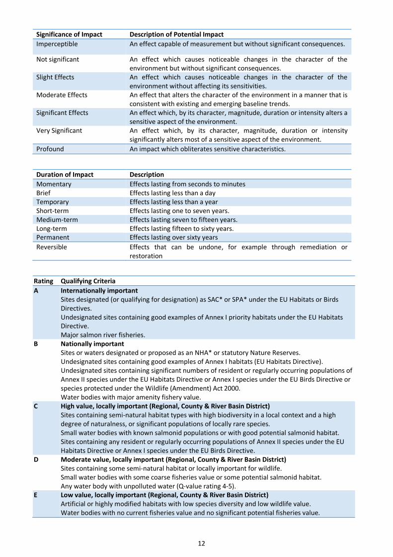
Significance of Impact Description of Potential Impact
Imperceptible An effect capable of measurement but without significant consequences.
Not significant An effect which causes noticeable changes in the character of the environment but without significant consequences.
Slight Effects An effect which causes noticeable changes in the character of the environment without affecting its sensitivities.
Moderate Effects An effect that alters the character of the environment in a manner that is consistent with existing and emerging baseline trends.
Significant Effects An effect which, by its character, magnitude, duration or intensity alters a sensitive aspect of the environment.
Very Significant An effect which, by its character, magnitude, duration or intensity significantly alters most of a sensitive aspect of the environment.
Profound An impact which obliterates sensitive characteristics.
Duration of Impact Description
Momentary Effects lasting from seconds to minutes Brief Effects lasting less than a day Temporary Effects lasting less than a year Short-term Effects lasting one to seven years. Medium-term Effects lasting seven to fifteen years. Long-term Effects lasting fifteen to sixty years. Permanent Effects lasting over sixty years
Reversible Effects that can be undone, for example through remediation or restoration
Rating Qualifying Criteria
A Internationally important Sites designated (or qualifying for designation) as SAC* or SPA* under the EU Habitats or Birds Directives. Undesignated sites containing good examples of Annex I priority habitats under the EU Habitats Directive. Major salmon river fisheries.
B Nationally important Sites or waters designated or proposed as an NHA* or statutory Nature Reserves. Undesignated sites containing good examples of Annex I habitats (EU Habitats Directive). Undesignated sites containing significant numbers of resident or regularly occurring populations of Annex II species under the EU Habitats Directive or Annex I species under the EU Birds Directive or species protected under the Wildlife (Amendment) Act 2000. Water bodies with major amenity fishery value.
C High value, locally important (Regional, County & River Basin District) Sites containing semi‐natural habitat types with high biodiversity in a local context and a high degree of naturalness, or significant populations of locally rare species. Small water bodies with known salmonid populations or with good potential salmonid habitat. Sites containing any resident or regularly occurring populations of Annex II species under the EU Habitats Directive or Annex I species under the EU Birds Directive.
D Moderate value, locally important (Regional, County & River Basin District) Sites containing some semi‐natural habitat or locally important for wildlife. Small water bodies with some coarse fisheries value or some potential salmonid habitat. Any water body with unpolluted water (Q‐value rating 4‐5).
E Low value, locally important (Regional, County & River Basin District) Artificial or highly modified habitats with low species diversity and low wildlife value. Water bodies with no current fisheries value and no significant potential fisheries value.

13
Table 1. Impact Matrix
Impact level Site Category A sites
Internationally important
B sites Nationally important
C Sites High value, Locally important
D sites Moderate value, locally important
E Sites Low value, locally important
Severe adverse
Any permanent impacts
Permanent impacts on a large part of a site
Major adverse
Temporary impacts on a large part of a site
Permanent impacts on a small part of a site
Permanent impacts on a large part of a site
Moderate adverse
Temporary impacts on a small part of a site
Temporary impacts on a large part of a site
Permanent impacts on a small part of a site
Permanent impacts on a large part of a site
Minor adverse
Temporary impacts on a small part of a site
Temporary impacts on a large part of a site
Permanent impacts on a small part of a site
Permanent impacts on a large part of a site
Negligible No impacts No impacts No impacts No impacts Permanent impacts on a small part of a site
Minor beneficial
Permanent beneficial impacts on a small part of a site
Permanent beneficial impacts on a large part of a site
Moderate beneficial
Permanent beneficial impacts on a small part of a site
Permanent beneficial impacts on a large part of a site
Major beneficial
Permanent beneficial impacts on a small part of a site
Permanent beneficial impacts on a large part of a site
Results Proximity to Designated Conservation Sites Designated conservation sites (National and international) within 15km of the proposed inshore elements of the cable route were examined. The landfall area has several overlapping conservation designations. The SPA terminates at the concrete wall above the high tide limit and goes into the subtidal, while the SAC goes into above the HWM into the car park and terminates in the subtidal. There are also two further overlapping conservation sites (pNHA and Ramsar); the pNHA mirrors the SAC while the Ramsar boundary is more akin to the SPA, although slightly lower than it (Figure 5). The distance of travel of the cable within each of the conservation sites is as follows; SAC/pNHA (6.2km), SPA (6.6km), Ramsar (6.2km). The conservation sites within 15km of the in the vicinity of the cable and the proposed landfall are seen in Figures 5-9.The distance of the proposed cable route to conservation sites are seen in Table 4.

14
Table 2. Natura 2000 sites within 15km of the proposed site
Code NATURA 2000 Site Distance
Special Areas of Conservation
000268 Galway Bay Complex SAC Route passes through site
000213 Inishmore Island SAC 1.6 km
000297 Lough Corrib SAC 1.9 km
000020 Black Head-Poulsallagh Complex SAC 1.9 km
001275 Inisheer Island SAC 3.1 km
000212 Inishman Island SAC 3.3 km
002034 Connemara Bog Complex SAC 7.7 km
001926 East Burren Complex SAC 9.4 km
000054 Moneen Mountain SAC 9.6 km
000994 Ballyteige (Clare) SAC 10.5 km
000036 Inagh River Estuary SAC 10.6 km
000996 Ballyvaughan Turlough SAC 10.8 km
000606 Lough Fingall Complex SAC 11.2 km
002111 Kilkieran Bay and Islands SAC 11.8 km
001285 Kiltiernan Turlough SAC 14.3 km
Special Protection Areas
004031 Inner Galway Bay SPA Route passes through site
004152 Inishmore SPA 3.2 km
004005 Cliffs of Moher SPA 4.1 km
004042 Lough Corrib SPA 5.1 km
004142 Cregganna Marsh SPA 5.9 km
004181 Connemara Bog Complex SPA 9.7 km
Natural Heritage Areas
Galway Bay Complex Route passes through site
Black Head-Poulsallagh Complex 2.0 km
Lough Corrib 2.9 km
Inisheer Island 3.1 km
Inishmaan Island 3.3 km
Inishmore Island 3.5 km
Furbogh Wood 4.6 km
Kiltullagh Turlough 6.2 km
Connemara Bog Complex 7.7 km
Cliffs of Moher 3.8 km
East Burren Complex 9.4 km
Moneen Mountain 9.7 km
Lough Goller 8.5 km
Caherkinalia Wood 9.2 km
Ramsar
- Inner Galway Bay Route passes through site
- Lough Corrib 5.7 km

15
Figure 5. Designated Conservation Sites' boundaries at proposed cable landfall

16
Figure 6. Special Areas of Conservation within 15km of the proposed development.

17
Figure 7. Special Protection Areas within 15km of the proposed development.

18
Figure 8. Natural Heritage Areas within 10km of the proposed development.

19
Figure 9. Ramsar sites within 10km of the proposed development

20
Subtidal – Desk based
As previously stated, the proposed Zone of Influence (ZoI) within the subtidal is expected to be extremely narrow
due to the narrow width of the plough (4m) and slow vessel speeds (0.5kn). However, it was conservatively
extended to 1km either side of the cable, out to the 12nm limit as “it is very unlikely that the impacts on integrity
can be evaluated without considering functions and processes acting outside the site’s formal boundary” (IEEM,
2010). The assessed ZoI is calculated as 200km2 (100km x 2km) out to the 12nm Limit (Figure 10) It should be noted
however that the cable is only 38mm in diameter. The proposed fibre-optic cable route within the 12 nm limit is
approximately 102km long and reaches a maximum water depth of approximately 150m within Irish Territorial
waters.
Habitats
Data from the NPWS 2006 Surveys of sensitive subtidal benthic communities in Slyne Head Peninsula SAC, Clew
Bay Complex SAC and Galway Bay Complex SAC (MERC, 2006) was interrogated.
Infomar backscatter, multibeam in addition to satellite imagery, Admiralty Charts and BioMar data were assessed,
where available and relevant, for the entire route within the 12nm. Infomar imagery is seen in Figure 12. Shallow
subtidal areas were examined using Orthophotography (OSI-1995, 2000 and 2005) in addition to satellite imagery
(Google (historic) & Bing). Such imagery has proved useful in the 2004-2010 NPWS sensitive subtidal benthic
communities surveys project to highlight potential seagrass areas (Zostera marina ) and allow for confirmation by
ground truthing.
As can be seen from Figure 11, based on a desktop evaluation, distinct habitats were distinguishable (EUSensmap
2019 data) along sections of the cable route out of Galway Bay. Within the Bay these were classed as mainly mud
and mixed sediment. From here out to the 12nm limit the seabed type appears to be mainly medium to fine sand
(Figures 11 & 12). The absence of reef areas along the route are seen in Figures 10 and 11.
Fisheries
Data from the inshore fisheries atlas was obtained and is shown in Figure 13. Fisheries based activity is carried out
from the landfall area right up to the edge of the territorial waters. In Galway Bay Line, trawl and pot fishing are
seen in Figure 13.

21
Figure 10. Marine habitats out to the 12nm limit (EUSensMap 2019)

22
Figure 11. Offshore habitats and proximity to offshore SAC’s.

23
Figure 12. Shaded Relief data for Galway Bay (Infomar)

24
Figure 13. Fisheries activity in the vicinity of the propose route (Marine Institute data).

25
Habitats and Species – On-Site Fieldwork Intertidal
During fieldwork, habitats in the vicinity of the intertidal route were classified according to Fossitt (2000) (Figure
14). Observations on species were made on a receding tide, as well as at Low Water.
GA2-Amenity Grassland
Amenity grassland was found in the vicinity of the proposed HDD and beach manhole site (Plate 1) and between
the road and beach (Figure 14). This habitat is approximately 2m above the OSI high tide limit and is behind a
concrete seawall of approximately 1.2m high. The site is well maintained and appears to be regularly cut. Species
diversity is poor with daisy (Bellis perennis), dandelion (Taraxacum spp.), clovers (Trifolium spp.), plantains
(Plantago spp.), creeping buttercup (Ranunculus repens), nettle (Urtica dioica) and docks (Rumex spp.).
Plate 1. Proposed position of the HDD on Amenity grassland.
BL-Built Land
Built land in the vicinity of the proposed works included the roads, footpaths, walls and car parking areas, (Figures
3 & 14). These areas are of low biodiversity importance and will not be impacted by the proposed works. It is
proposed to use the HDD to go under these areas and not impact on the structural integrity of these areas.
LS1-Shingle and gravel shores
The upper part of the beach is dominated by a gravel and cobble beach approximately 10-20m wide, which backs
up to a concrete retaining wall (Plate 2 inset). The presence of this gravel/cobble area would tend to indicate that
the beach is moderately exposed to wave action and storms that have sufficient strength to form a storm beach.
Algal drift lines were present on the cobble storm beach and at the time of survey and were dominated by Fucoids
and Laminaria species.
LS2 Sand Shores
The majority of the intertidal cable route consists of Littoral Sediment- Sand shores. Invasive investigations were
not carried out. Casts of juvenile Arenicola marina were noted in the wetter portion of the habitat where water
appeared to drain from the upper part of the beach and was retained on the surface(Plate 2). The proposed HDD
will be located in the amenity grassland area on the north side of the road (Plate 1) will finish below the foreshore
(Plate 2) in the upper intertidal, within this habitat.
HDD and beach
manhole location

26
Figure 14. Fossitt (2000) habitats at the landfall area.

27
Plate 2: Uppershore on Ballyloughane Beach with the approximate location of the cable route (wall inset).
LS3-Muddy sand shores
Further down the beach towards the LWM the beach became more of a muddy sand and numerous juvenile
Arenicola marina casts and areas of brown microalgae were noted (Plate 3). This area extended to the sublittoral
i.e. SS2 Infralittoral muddy sands, which was surveyed by boat and video camera. No seagrass (Zostera sp) was seen
in either of these habitats. A small stream was located in this area on the western portion of the beach.
Plate 3: Mid-Lower shore on Ballyloughane Beach (2021) with the approximate location of the cable route
HDD
Plough Burial

28
LR2 Moderately exposed rocky shores
On either side of the sandy beach habitat are areas an intertidal reef. On the western side of the proposed cable
route this area is primarily of boulders while on the eastern side this area is made up of cobble and boulders with
varying amounts of sand interspersed between the rocks. This area is at minimum 35m from the proposed cable
route. Species were typical of rocky shore, species encountered included Fucus vesiculosus, Fucus serratus, Fucus
spiralis, Elachista fucicola, Ulva intestinalis, Palmaria palmata, Mastocarpus stellatus, Ceramium sp., Chondrus
crispus, Cladophora rupestris, Ascophyllum nodosum and at lower levels Laminaria digitata. This area extended to
the sublittoral i.e. SR5 Moderately exposed circalittoral rock, which was not surveyed.
CM1-Lower Salt Marsh
A small area of saltmarsh was noted on the eastern side of the beach. This area is in a small elevated portion of the
beach, nestled behind the rocky shore and would be expected to be covered at high tide spring tides. This habitat
appears to be relatively recent as it is not seen on 1995 orthography but is present in 2000 and is relatively stable
in extent since 2000. This habitat is not in vicinity of the proposed cable route. During 2021 the level of human
disturbance in this area was significant.
Additional Habitats
A range of habitats of conservation importance have been recorded and mapped in this area by NPWS. These are
detailed in the NIS. The distribution maps of these habitats in the NIS indicate that the proposed cable route is not
proximal to the majority of habitats of conservation interest including Coastal lagoons, Reefs, Perennial vegetation
of stony banks, Salicornia and other annuals colonising mud and sand, Atlantic salt meadows (Glauco-
Puccinellietalia maritimae), Mediterranean salt meadows (Juncetalia maritimi), Turloughs, Juniperus communis
formations on heaths or calcareous grasslands, Semi-natural dry grasslands and scrubland facies on calcareous
substrates (Festuco Brometalia, Calcareous fens with Cladium mariscus and species of the Caricion davalliana or
Alkaline fens saltmarsh areas. However, the cable route passes through the habitats Mudflats and sandflats not
covered by seawater at low tide (on Ballyloughane Beach) and subtidal elements of the habitat Large shallow inlets
and bays.
Species
Birds
The proposed landfall is an important area for overwintering birds. Please see main NIS document for information
on the species of importance in this area. The site was visited outside of overwintering bird season. Bird species
noted on site included black-headed gull (Larus ridibundus), little egret (Egretta garzetta), grey heron (Ardea
cinerea) and pied wagtail (Motacilla alba yarrellii).
Amphibians
The common frog (Rana temporaria) was not observed in the amenity grassland or surrounding terrestrial areas.
NPWS records of rare and threatened species in addition to the NBDC sightings records were investigated and
showed no records in proximity of the landfall or beach area. No streams or drainage ditches were observed in the
terrestrial element of Ballyloughane Beach. No amphibians of conservation importance are recorded on NPWS data.
Terrestrial Mammals
No badger setts or evidence of terrestrial mammals of conservation importance were seen in the vicinity of the
landfall area. Records of sightings of the badger, pine marten, otter and hedgehog were examined from the NBDC
and NPWS rare and threatened species records showed no records in proximity of the landfall area. However, the
conservation objectives supporting document highlights a 250m buffer from High Water as otter habitat within the
SAC. Otters were not observed on site.

29
Sensitive Subtidal Communities
The habitats and factors impacting on the shallow subtidal element of the proposed cable route in the vicinity of the landfall are relatively complex. In order to understand the distribution of sensitive subtidal communities within the Galway Bay Complex SAC, data from the NPWS 2006 Surveys of sensitive subtidal benthic communities in Slyne Head Peninsula SAC, Clew Bay Complex SAC and Galway Bay Complex SAC (MERC, 2006) were interrogated (Figure 15). The raw GIS scuba diving mapping data (thick lines) and the defined Conservation Objectives habitat boundaries (polygons) from this survey were overlaid on the initial proposed cable route. This original route (most southern) was deemed proximal to recorded maerl sites. The cable is not in the vicinity of recorded Zostera marina sites.
Following this initial assessment the route was modified and moved northwards, towards the navigation channel, to avoid recorded sensitive communities. A follow up drop-down video survey of the revised route was then carried out within the SAC in May 2018 to 1km beyond the SAC boundary, to identify the communities present and fine tune the proposed routing to avoid sensitive communities. Virgularia mirabilis and maërl communities (sprinkling on mixed sediment) were noted in several locations (Plates 4 & 5) outside areas previously surveyed. Where these were encountered along the route, additional video drops were carried out, perpendicular to the route in a northwards direction, towards the shipping lane. Note was taken of where the communities were no longer present along this transect. The proposed cable route was revised again (Figure 15-Cable route Proposed) to avoid these sensitive communities where possible. It should be noted that in discussions with the Harbour Master of Galway Port the proposed port expansion shapefile was acquired and overlaid in relation to the proposed cable route and sensitive subtidal communities.
As outlined in MERC (2006) “The over-riding feature of many of the maërl communities in this part of Galway Bay appears to be their nature. Rather than forming large beds of dense living and non-living maërl, in many cases the communities form a thin and broken veneer on top of various sedimentary seabed types, including fine and coarse sand, gravels, cobbles and muds in some instances. Where the veneer of maërl occurs with coarse gravel and cobbles, the maërl tends to occupy the spaces between grains. The covering frequently is only one layer thick (i.e. the thickness of a single rhodolith). Within these communities, the surface area covering of maërl can vary from 100% to as little as 10% and they were seen to stretch over very large areas of the seabed. Within these areas significant variability in the nature of the underlying sediments was also recorded. However the covering of maërl can be seen to extend throughout all such variability in sediments. In many cases it is perhaps questionable as to whether the occurrence of maërl in this manner actually constitutes a maërl community or not.” Despite this, the route was revised to avoid areas where maerl was found on the video survey.
MERC 2006 also stated that the “species of maërl recorded included the discoidal form of Lithothamnion corallioides to the north of Finavarra and to the east and north of Aughinish Island. Also recorded was Phymatolithon calcareum in Muckinish Bay. Further deposits of the finely branched form of Lithothamnion coralloides were recorded in Doorus Strait, as well as to north of Tawin Peninsula” (in the vicinity of the proposed cable route) “where maërl communities formed an extensive veneer over underlying muddy and muddy sand sediments. No Lithophyllum dentatum was recorded during the survey of Galway Bay Complex SAC.”
In relation to the Virgularia mirabilis MERC 2006 stated that “despite conducting a number of specific dives in order to investigate other ‘known’ sensitive communities – most notably for Neopentadactyla mixta and the Sea Pen Virgularia mirabilis in the area to the north of Tawin Peninsula and south of Mutton Island, no such communities were recorded. Indeed, other than very occasional individual Lanice conchilega no other significant subtidal species or communities were encountered during the survey at this site.” The area where the Virgularia mirabilis was noted during the 2018 camera survey, was not covered by the 2006 surveys. No Neopentadactyla mixta was noted during these surveys. As stated previously the proposed route was modified to avoid these sensitive areas. It should be stated that the camera survey carried out as part of the EcIA/NIS extends the current known distribution of Maerl but has now identified the location of Virgularia mirabilis within Galway Bay Complex SAC.

30
Figure 15. Inshore subtidal communities recorded, routing options assessed and future expansion plans for Galway Port.

31
Knowing the proposed future expansion of the port and navigation channel has allowed for the movement of the cable to minimise the impact on sensitive habitats while ensuring the future safety of the cable. This area in the vicinity of the future port expansion is particularly constrained by the future navigation channel and it may not be possibly to avoid this habitat in this specific area. As discussed with NPWS, two surveys were carried out in 2021 to assess the optimal route for the cable in this area taking into account the future development plans of the port and the distribution of Virgularia mirabilis. As seen in Figure 15 the 2021 survey showed that the originally proposed route (yellow dashed line) had the potential to interact with areas of Virgularia mirabilis habitat. As a result of the 2021 survey the cable was moved north in the outer areas of the SAC. Within proximity of the Galway Port expansion the cable is restricted between port development and areas where burial is not possible. Therefore, rerouting in this area is tightly constrained. It should be noted however that the plough (4m wide) is on skids and stays on the seabed surface while only the blade itself penetrates deep into the sediment. As speeds are slow (1kn) it would be expected that the laying of the cable in this habitat would be short-term impact and would not impact on the medium & long-term integrity of this habitat.
Plate 4. Virgularia mirabilis noted during this camera survey.
Plate 5. Mearl noted during the 2018 camera survey.

32
Cetacean Species
In O’Brien (2013) “a total of 28 dedicated land-based visual watches were carried out from Spiddal Pier (2700 minutes/45 hours) between March 2005 and February 2007. Cetaceans were recorded during 10 of the 27 watches (37%). A total of 16 sighting were recorded during watches comprising of three species; including, harbour porpoise (81%), bottlenose dolphin (13%) and Minke whale (7%). Only a single sighting of two harbour seals was recorded on one occasion. All sightings recorded were within a 5km radius of Spiddal pier. Most sightings (75%) were recorded between the months June to December with only 25% of sightings recorded in the period January to May, highlighting mid-summer through to December as the months when porpoises are most active at the site.
The OE Test site was again the target of long-term Static Acoustic Monitoring (SAM) as part of the PReCAST project, when monitoring commenced in January 2009 and continued until September 2010. During this time a total of 572 days were monitored at the site. SAM monitoring from January 2009 to September 2010 at the test site show that, on average, harbour porpoises were recorded on 95% of days monitored, while dolphins were rarely recorded (4%days). These results reflect those of the SAM I. Over the 572 days monitored, a total of 27,902 porpoise Detection Positive Minutes (DPM) were recorded (4,515 Detection Positive Hours; DPH). As dolphin sightings were rare, only the porpoise data were analysed to identify factors influencing their presence at the site.
Results from visual and acoustic monitoring are very similar as all show that autumn and winter months are when porpoises are most active at the site. Visual data shows that in comparison with other sites in the bay subjected to land-based watches, Spiddal is not the most important, with a greater relative abundance recorded from Black Head on the south shore. This is most likely due to the tidal nature at Black Head as porpoises are known to use tidal races when feeding.”
Figure 16 shows all cetacean species, and Figure 17 shows monthly activity trends, in the area as recorded by IWDG sightings scheme. Cetacean activity has been seen in the vicinity of the cable route corridor. Species seen in the area and along the cable route include bottle-nosed dolphin (Tursiops truncates) (especially in inner Galway Bay and inshore areas along route), harbour porpoise (Phocoena phocoena), common dolphin (Delphinus delphis), minke whale (Balaenoptera acutorostrata, and a single killer whale (Orcinus orca). During the months of proposed survey and cable laying bottle-nosed dolphin (Tursiops truncatus) harbour porpoise (Phocoena phocoena), common dolphin (Delphinus delphis) have been recorded.

33
Figure 16. Recorded cetacean species sightings (Source: IWDG)

34
Figure 17. Recorded Cetacean sightings (Source IWDG Sightings Data) in the inshore area recorded during the 12 months of the year.

35
Harbour Seals
Inner Galway Bay is an important site for harbour seals but, not for grey seals (Figure 18). As outlined in the Galway
Bay Complex SAC (site code: 0268) Conservation objectives supporting document - Marine habitats and species,
“harbour seals in Galway Bay Complex SAC occupy both aquatic habitats and intertidal shorelines that become
exposed during the tidal cycle. The species is present at the site throughout the year during all aspects of its annual
life cycle, which includes breeding (May to July approx.), moulting (August to September approx.) and non-breeding
foraging and resting phases. In particular, comparatively limited information is available from the last period in the
annual cycle spanning the months of October to May.
Harbour seals are vulnerable to disturbance during periods in which time is spent ashore or in shallow waters by
individuals or groups of animals. This occurs immediately prior to and during the annual breeding season which
takes place predominantly during the months of May to July. Pups are born on land usually on sheltered shorelines,
islets or skerries and uninhabited islands removed from the risk of predation and human interference.” “Current
known sites are broadly within the following areas: Oranmore Bay, Kinvarra Bay, Aughinish Bay, Poulnaclogh Bay,
Ballyvaghan Bay, Rabbit Island, Earl’s Rock, St. Brendan’s Island, Ardfry Point, Tawin Island, Glasheen Island and
Deer Island.
The necessity for individual seals to undergo an annual moult (i.e. hair shedding and replacement), which generally
results in seals spending more time ashore during a relatively discrete season, provides an opportunity to record
the minimum number of harbour seals occurring in a given area (i.e. minimum population estimate). Moulting is
considered an intensive, energetically-demanding process which incurs further vulnerability for individuals during
this period. Terrestrial or intertidal locations where seals can be found ashore are known as haul-out sites. The
harbour seal moult season takes place predominantly during the months of August to September. A total of 317
harbour seals were recorded ashore within Galway Bay Complex SAC in August 2003 during a national aerial survey
for the species. Suitable habitat for the species along with known moult haul-out locations in Galway Bay Complex
SAC. “This broadly consists of Oranmore Bay, Kinvarra Bay, Aughinish Bay, Poulnaclogh Bay, Ballyvaghan Bay and
on Black Rock, Earl’s Rock and St. Brendan’s Island, Tawin Island and Glasheen Island, Ringeelaun Point and Deer
Island.”
The proposed location of the cable survey and main lay are not in the vicinity of resting, moulting or breeding sites
(See NIS). However, it is noted that as outlined in NPWS 2013 “in acknowledging the limited understanding of
aquatic habitat use by the species within the site, it should be noted that all suitable aquatic habitat is considered
relevant to the species range and ecological requirements at the site and is therefore of potential use by harbour
seals.” As a result, despite the location of the survey and cable outside key activity areas, the survey and main lay
teams will need to be cognisant of this and take into account due diligence in relation to seal disturbance when
deploying and recovering equipment.
Offshore Area (12nm-limits to limits of EEZ)
The proposed fibre optic cable route in relation to the Irish EEZ, designated Irish Continental shelf, 12nm Limit
and Offshore SAC’s for Cold Water Corals are seen in Figure 19. Information on mounds which could potentially
host biogenic reef (Lophelia pertusa) populations, not currently afforded protection are seen in Figure 20.
The entire route, within the Irish EEZ, was examined using shaded relief service of bathymetry data collected by
INFOMAR (where available). The closest the fibre optic cable route comes to mounds, or obvious anomalies that
could potentially host significant biogenic reef forming populations of Lophelia pertusa, is 19km (Figure 20). The
closest designated area to the proposed cable route in the offshore area is 30km, due south of the Hovland
Mound Province SAC (Figure 21).
Predicted marine habitat data for the offshore section of the fibre optic cable route is shown in Figure 22 (Source
MSFD mapping Marine Institute). Figure 23 shows offshore cetacean activity as recorded by IWDG sightings
scheme, in addition to all sightings during August the month of the proposed routing of the fibre optic cable.

36
Figure 18. Harbour seal (red) and grey seal (yellow) distribution (green) and haul-out sites in the inshore area. (NPWS).

37
Figure 19. Offshore SAC’s

38
Figure 20. Recorded Lophelia records..

39
Figure 21. Infomar backscatter and Lophelia records.

40
Figure 22. Recorded Cetacean sightings (Source IWDG Sightings Data) in the inshore area recorded during the 12 months of the year.

41
Potential Impacts The installation of a deep sea fibre-optic cable is a complex and challenging procedure. From the beginning of the
planning stage to the final installation the cable, careful thought has gone into ensuring the longevity of the cable
and uninterrupted service. This, in tandem with foreshore licencing and environmental legislation results in the
placement of the cable in as stable an environment as possible that will have minimal impact on the environment
and threat of anthropogenic disturbance. In summary, within the 12nm limit, the laying of the cable will involve
ploughing in sediment, surface laying on hard substrate (if encountered) and elements of diver works in the shallow
subtidal. The intertidal elements will involve plough burial, followed by back-blading. Even though there are two
distinct elements to this project i.e. subtidal and intertidal, both elements are inextricably linked are treated
together for the analysis of potential impacts. Terrestrial elements of this project from the beach manhole are
treated in a separate application process.
Construction Impacts Ploughing will involve the disturbance of the seabed to 1.5m where possible. Immediate backfilling is a feature of
the plough to be used. In the subtidal the process will involve a ship moving at a speed of approximately 0.5kn and
generating acoustic noise akin to dredging activity. A plume of sediment will be generated. However, due to the
speeds and equipment (on skids) involved this plume will be very localised. Disturbance of cetaceans may occur
due to the presence of the vessel however, at the speeds involved injury to marine mammals is unlikely. There is
only little information on potential noise impacts due to the installation (or removal) and operation of sub-sea
cables (OSPAR 2008a). Sound emissions associated with the installation, removal or operation of submarine cables
are considered as less harmful compared to activities such as seismic surveys, military activities or construction
work involving pile driving. Generally, maximum sound pressure levels related to the installation or operation of
cables are moderate to low (OSPAR, 2012). Though modern equipment and installation techniques can reduce the
re-suspension of sediment during cable burial or removal, remaining suspended sediment may nonetheless -
depending on percentage of silt fraction and background levels - obstruct the filtration mechanisms of some benthic
and pelagic organisms at least temporarily (OSPAR 2009). It can also affect the growth of the macrobenthos and
may have a lethal effect on some species. Some mobile benthic species (for example, crabs) are able to avoid most
disturbance whereas sessile (bivalves, tubeworms etc.) and sensitive species (such as slower growing or fragile
species) will be more impacted (OSPAR, 2012). Contamination arising from seabed disturbance is only a risk in
heavily contaminated locations (OSPAR 2009, COOPER et al. 2007a, 2007b). By surface laying over hard ground the
cable will only create a narrow footprint on the seabed that may inhibit growth of marine flora and fauna due to
the presence of the cable. No rock armour will be carried out in these areas.
The presence of machinery and personnel in the intertidal may temporally disturb wildlife. Disturbance of the
sediments in the intertidal will occur due to ploughing. Construction of the beach manhole will be carried out in the
grass area to the north of the road. The preparation of a beach manhole will also generate noise in the vicinity of
the beach. Pollution generated from machinery/construction activities could potentially impact the intertidal
habitat. Mitigation measures are proposed. Potential impacts on habitats and species and the extent of these
impacts that could potentially be encountered during the construction phase are seen in Table 5a (habitats) and 5b
(species).

42
Table 5a. Potential impacts on habitats during construction.
Habitat Fossitt Habitats Directive Rating Construction Impact Impact Significance
Moderately Exposed Infralittoral Rock
SR2 “Reef - 1170” A Laying of the cable will not occur in the vicinity of this habitat. No impact is foreseen on the structural integrity of this habitat. Temporary disturbance would occur due to cobbles, if present, being turned over.
Minor Adverse/ localised/short-term
Moderately Exposed Circalittoral Rock
SR5 “Reef - 1170” A Surface laying will occur on this habitat in offshore bedrock areas. In areas of cobble ploughing may be carried out. No impact is foreseen on the structural integrity of this habitat. Temporary disturbance would occur due to cobbles, if present, being turned over.
Minor Adverse/ localised/short-term
Sand Shores LS2 “Estuaries – 1130”and “Mudflats and sandflats not covered by seawater at low tide-1140”
A These habitat is classed as Mudflats and sandflats not covered by seawater at low tide and do form part of sites of conservation interest and are the feeding habitat of the over wintering birds of conservation importance. As a result this sandflat habitat is classed as internationally important. However the cable route is an area of significant existing disturbance (See NIS). Temporary displacement of birds may occur in the vicinity of the cable route. Works will be outside of overwintering period. Short term impacts would be expected on infauna due to compression/redistribution of sediments. Mitigation measures are proposed.
Minor Adverse/ localised/short-term
Shingle and gravel shores
LS1 B Ploughing will not occur in this area. The HDD will go under this habitat. Machinery may cross this habitat to access beach.
Minor Adverse/ localised/short-term
Muddy sand shores LS3 D These habitat is classed as Mudflats and sandflats not covered by seawater at low tide and do form part of sites of conservation interest and are the feeding habitat of the over wintering birds of conservation importance. As a result this sandflat habitat is classed as internationally important. However the cable route is an area of significant existing disturbance (See NIS). Temporary displacement of birds may occur in the vicinity of the cable route. Works will be outside of overwintering period. Short term impacts would be expected on infauna due to compression/redistribution of sediments. Mitigation measures are proposed.
Minor Adverse/ localised/short-term
Circalittoral gravels and Sands
SS5 D Ploughing will occur in this area offshore. A temporary alteration in sediment layering would follow the ploughing process. Infauna may be damaged or displaced in the vicinity of the plough.
Minor Adverse/ localised/short-term
Circalittoral Mixed sediments
SS8 D Ploughing will occur in this area offshore. A temporary alteration in sediment layering would follow the ploughing process. Infauna may be damaged or displaced in the vicinity of the plough.
Minor Adverse/ localised/short-term
Built Land BL E All works will be away from BL3. The HDD will be under the road. Neutral Amenity Grassland GA2 E Machinery will be placed on the amenity grassland during HDD operations.
The habitat is of low biodiversity importance and will be reinstated. Neutral

43
Table 5b. Potential impacts on habitats during construction.
Species Rating Construction Impact Impact Significance
Mammal-Cetaceans A Subtidal survey and cable laying may be carried out in vicinity of cetaceans. Localised disturbance may occur due to the presence of the vessel and acoustic noise generated from cable laying activities on the sea floor. A MMO will be on vessel at all times (Seen NIS for more detail).
Minor Adverse/ localised/short-term
Mammal-Seals A Subtidal survey and cable laying may be carried out in vicinity of seals. Localised disturbance may occur due to the presence of the vessel and acoustic noise generated from cable survey and laying activities. Cable laying is to be carried out outside of breeding and haul out areas for Grey, but will be carried out during breeding period for Harbour seals. Vessel speeds will be slow. A MMO will be on board the vessel to enforce mitigation measures.
Minor Adverse/ localised/short-term
Mammal-Bats A There was no evidence of bat species at this site. Construction in the intertidal will be carried out during daylight hours and will not involve additional lighting or noise after dusk. It will not impact on the food source for bat species or habitats important for roosting. If HDD operations extend beyond daylight hours the temporary presence of lighting or noise would not significantly impact bat populations.
Neutral
Mammals-Terrestrial
A-D Construction in the intertidal and the HDD area will be carried out during daylight hours and any impacts would be primarily due to disturbance. There was no evidence of terrestrial mammal species at this site. However it is assumed that mammal species could be present including otters, even though this is a popular area for dog walking etc. An ecologist will be present during intertidal and HDD works.
Minor Adverse/ localised/short-term
Birds-Over wintering
A Survey and construction in the intertidal and HDD area will be carried out during daylight hours and impacts would be primarily due to disturbance. During the survey and construction period the over wintering birds will be absent from the site.
Neutral
Birds-Summer B Construction in the intertidal and HDD area will be carried out during daylight hours and impacts would be primarily due to disturbance. An ecologist will be onsite during the HDD and cable laying to ensure birds and the intertidal sandflat habit are not significantly impacted.
Minor Adverse/ localised/short-term
Birds-residential D Survey and construction in the intertidal and HDD area will be carried out during daylight hours and impacts would be primarily due to disturbance. An ecologist will be onsite during the HDD and cable laying to ensure birds and the intertidal sandflat habit are not significantly impacted.
Minor Adverse/ localised/short-term
Amphibians-Frogs B The intertidal area is not a habitat for amphibian species. Amphibians were not noted in the amenity grassland area. An ecologist will be on site to ensure species of conservation importance are not impacted.
Neutral
Terrestrial Flora - The terrestrial element of this project is solely in amenity grassland area. No flora of conservation importance were noted.
Neutral
Marine algae D Intertidal marine algae are not located along the proposed route. 35m to the east is an area of intertidal reef. Subtidal marine algae are primarily associated with hard substrata and will be impacted by surface laying. Localised displacement of marine algae may occur within the footprint of the cable in the subtidal if reef is encountered but the route has been selected to avoid these areas.
Minor Adverse/ localised/short-term
Fish Species A Ballyloughane Beach is not an important salmonid habitat. Localised disturbance of marine species may occur due to ploughing and ROV based burial activities. Vessel speeds are very slow and significant impacts on fish would be expected to be avoided during works. Post works, fish may be attracted to the area due to the disturbed sediment.
Minor Adverse/ localised/short-term

44
Table 6a. Potential impacts on habitats during construction.
Habitat Fossitt Habitats Directive Rating Operational Impact Impact Significance
Moderately Exposed Infralittoral Rock
SR2 “Reef - 1170” A No significant heat or EMF emissions in to the marine environment are foreseen. The structural integrity of the habitat will not be impacted.
Neutral
Moderately Exposed Circalittoral Rock
SR5 “Reef - 1170” A No significant heat or EMF emissions in to the marine environment are foreseen. The structural integrity of the habitat will not be impacted.
Neutral
Sand Shores LS2 A The cable will be buried in the marine sediment and no impacts are foreseen. Neutral
Shingle and gravel shores
LS1 B The cable will be buried in the marine sediment and no impacts are foreseen. Neutral
Muddy sand shores LS3 B The cable will be buried in the marine sediment under this habitat and no impacts are foreseen.
Neutral
Circalittoral gravels and Sands
SS5 D The cable will be buried in the marine sediment and no long term impacts are foreseen. Invertebrate biodiversity may be negatively impacted in the short term by ploughing..
Minor Adverse/ localised/short-term
Circalittoral Mixed sediments
SS8 D The cable will be buried in the marine sediment and no long term impacts are foreseen. Invertebrate biodiversity may be negatively impacted in the short term by ploughing..
Minor Adverse/ localised/short-term
Built land BL E The cable will be located under built land i.e. road and no impact is foreseen. Neutral
Amenity Grassland GA2 E The cable will be located under this habitat. Access to the beach manhole may be required.
Neutral

45
Table 6b. Potential impacts on habitats during construction.
Species Rating Operational Impact Impact Significance
Mammal-Cetaceans A No acoustic noise is generated from the cable whilst in operation. Studies have shown that the danger of entanglement in modern cables is extremely remote due to the use of BAT in surface laying, burial and cable design.
Neutral
Mammal-Seals A No acoustic noise is generated from the cable whilst in operation. Studies have shown that the danger of entanglement in modern cables is extremely remote due to the use of BAT in surface laying, burial and cable design.
Neutral
Mammal-Bats A The cable will be buried beneath the intertidal and grassland area. No impact is foreseen on bat species. Neutral
Mammals-Terrestrial
A-D The cable will be buried beneath the intertidal and grassland area. No impact is foreseen on terrestrial mammal species.
Neutral
Birds-Over wintering
A The cable will be buried beneath the intertidal and subtidal areas. No impact is foreseen. Neutral
Birds-Summer B The cable will be buried beneath the intertidal and subtidal areas. No impact is foreseen. Neutral
Birds-residential D The cable will be buried beneath the intertidal and subtidal areas. No impact is foreseen. Neutral
Amphibians-Frogs B The cable will be buried beneath the intertidal and subtidal areas. No impact is foreseen. Neutral
Terrestrial Flora - The cable will be buried beneath the intertidal and subtidal areas. No impact is foreseen. Neutral
Marine algae D The cable will be buried beneath the intertidal and subtidal areas. No impact is foreseen. Neutral

46
Potential impacts on Cetaceans
All cetaceans are listed under Annex IV of the Habitats Directive, which means that they are protected wherever
they occur. Bottle-nosed Dolphin and Harbour Porpoise are also listed under Annex II of the Directive. Annex II
species require that core areas of their habitat are designated as sites of Community importance.
The proposed cable lay would be expected to impact on cetaceans primarily through the emission of noise due
to the vessel and acoustics from the USBL equipment. As outlined by O’Brien (2005), “sound travels 4.5 times
faster in water than in air and low frequency sounds travel farther underwater than high frequency sounds.”
Multi-beam can be defined as Low frequency (<1 kHz), Mid-frequency (1-10 kHz) and High Frequency (>10 kHz).
Southall et al. (2019) outlined in their publication “Marine Mammal Noise Exposure Criteria: Updated Scientific
Recommendations for Residual Hearing Effects” revised the marine mammal hearing groups, which are seen in
Table 7.
Table 7. Marine Mammal Functional Hearing Groups and Estimated Functional Hearing groups Proposed by Southall et al. (2019)
Marine mammal hearing group
Auditory weighting function
Genera (or species) included
Low-frequency cetaceans
LF Balaenidae (Balaena, Eubalaenidae spp.); Balaenopteridae (Balaenoptera physalus, B. musculus)
Balaenopteridae (Balaenoptera acutorostrata, B. bonaerensis, B. borealis, 1 B. edeni, B. omurai; Megaptera novaeangliae); Neobalenidae (Caperea);Eschrichtiidae (Eschrichtius)
High-frequency cetaceans
HF Physeteridae (Physeter); Ziphiidae (Berardius spp., Hyperoodon spp., Indopacetus, Mesoplodon spp., Tasmacetus, Ziphius); Delphinidae (Orcinus)
Delphinidae (Delphinus, Feresa, Globicephala spp., Grampus, 2 Lagenodelphis, Lagenorhynchus acutus, L. albirostris, L. obliquidens, L. obscurus, Lissodelphis spp., Orcaella spp., Peponocephala, Pseudorca, Sotalia spp., Sousa spp., Stenella spp., Steno, Tursiops spp.); Montodontidae (Delphinapterus, Monodon); Plantanistidae (Plantanista)
Very high frequency cetaceans
VHF Delphinidae (Cephalorhynchus spp.; Lagenorhynchus cruciger, L. austrailis); Phocoenidae (Neophocaena spp., Phocoena spp., Phocoenoides); Iniidae (Inia); Kogiidae (Kogia); Lipotidae (Lipotes); Pontoporiidae (Pontoporia)
Phocid carnivores in water
PCW Phocidae (Cystophora, Erignathus, Halichoerus, Histriophoca, Hydrurga,Leptonychotes, Lobodon, Mirounga spp., Monachus, Neomonachus, Ommatophoca, Pagophilus, Phoca spp., Pusa spp.)
The Technical Guidance for Assessing the Effects of Anthropogenic Sound on Marine Mammal Hearing (NOAA,
2018) outlined the hearing groups of marine mammals including the generalised hearing range of these
cetacean groups (Table 8). They also noted that “Exposures exceeding the specified respective criteria level for
any exposure metric are interpreted as resulting in predicted temporary threshold shift (TTS) or permanent
threshold shift (PTS) onset.” The onset of PTS on marine mammals was also outlined in NOAA 2018 (Table 9).
The updated figures for PTS and TTS for are outlined in Table 10.

47
Table 8. Hearing Groups of Marine Mammals (NOAA, 2018)
Hearing Group Generalized Hearing Range*
Low-frequency (LF) cetaceans (baleen whales) 7 Hz to 35 kHz
Mid-frequency (MF) cetaceans (dolphins, toothed whales, beaked whales, bottlenose whales)
150 Hz to 160 kHz
High-frequency (HF) cetaceans (true porpoises, Kogia, river dolphins, cephalorhynchid, Lagenorhynchus cruciger & L. australis)
275 Hz to 160 kHz
Phocid pinnipeds (PW) (underwater) (true seals) 50 Hz to 86 kHz
Otariid pinnipeds (OW) (underwater) (sea lions and fur seals) 60 Hz to 39 kHz * Represents the generalized hearing range for the entire group as a composite (i.e., all species within the group), where individual species’ hearing
ranges are typically not as broad. Generalized hearing range chosen based on ~65 dB threshold from normalized composite audiogram, with the
exception for lower limits for LF cetaceans (Southall et al. 2007) and PW pinniped (approximation).
Table 9. Onset of PTS in Marine mammals
PTS Onset Thresholds (Received Level)
Hearing Group Impulsive1 Non-impulsive2
Low-Frequency (LF) Cetaceans Cell 1 Lpk,flat: 219 dB LE,LF,24h: 183 dB Cell 2 LE,LF,24h: 199 dB
Mid-Frequency (MF) Cetaceans Cell 3 Lpk,flat: 230 dB LE,MF,24h: 185 dB Cell 4 LE,MF,24h: 198 dB
High-Frequency (HF) Cetaceans Cell 5 Lpk,flat: 202 dB LE,HF,24h: 155 dB Cell 6 LE,HF,24h: 173 dB
Phocid Pinnipeds (PW) (Underwater) Cell 7 Lpk,flat: 218 dB LE,PW,24h: 185 dB Cell 8 LE,PW,24h: 201 dB
Otariid Pinnipeds (OW) (Underwater) Cell 9 Lpk,flat: 232 dB LE,OW,24h: 203 dB Cell 10 LE,OW,24h: 219 dB
1Impulsive: produce sounds that are typically transient, brief (less than 1 second), broadband, and consist of high peak sound pressure with rapid rise
time and rapid decay (ANSI 1986; NIOSH 1998; ANSI 2005).
2Non-impulsive: produce sounds that can be broadband, narrowband or tonal, brief or prolonged, continuous or intermittent) and typically do not have
a high peak sound pressure with rapid rise/decay time that impulsive sounds do (ANSI 1995; NIOSH 1998).
Table 10. Southall et al. (2019) TTS- and PTS-onset thresholds for marine mammals exposed to impulsive noise: SEL thresholds in dB re 1
μPa2s under water and dB re (20 μPa)2s ; and peak SPL thresholds in dB re 1 μPa under water.
Hearing Group Impulsive Noise Non-impulsive Noise Unweighted SPLpeak(dB re 1 μPa)
Weighted SELcum (dB re 1 μPa2s)
Weighted SELcum (dB re 1 μPa2s)
PTS Criteria
Low-frequency (LF) cetaceans 219 183 199
High-frequency (HF) cetaceans 230 185 198
Very-frequency cetaceans (VHF) 202 155 173
Phocid carnivores in water (PCW) 218 185 201
TTS Criteria
Low-frequency cetaceans 213 168 179
High-frequency cetaceans 224 170 178
Very high-frequency cetaceans 196 140 153
Phocid carnivores in water 212 170 181
The hearing ranges and sensitivity of marine mammals differ from one species to another depending on their
audiogram. “For example, harbour porpoises are sensitive from 3 kHz to 130 kHz, with peak sensitivity at 125-
130 kHz, and bottlenose dolphins from 5-110 kHz, with peak sensitivity at 40 and 60-116 kHz” (Southall et al.,
2007). Common seals are sensitive 4-45 kHz (peak sensitivity at 32 kHz) and grey seals 8-40 kHz. Humans are
sensitive only to frequencies from 20 Hz to 16-18 kHz but with peak sensitivity from 2-4 kHz. Most small
cetaceans, excluding harbour porpoise, have an auditory bandwidth of 150 HZ to – 160 kHz, while harbour
porpoise have an auditory bandwidth within 200 Hz to 180 kHz. Pinnipeds in water are thought to have an
auditory bandwidth of between of 75 Hz to 75 kHz and from 75 Hz to 30 kHz in air (Southall et al. 2007).”
The proposed survey equipment and the noise frequency emissions are seen in Table 13. The low frequencies
emitted from the equipment (18-36 kHz) are below the auditory range of the high and very frequency

48
cetaceans but are within the hearing range of low frequency cetaceans that would be seen on the cable route
(Table 11).
Table 11. Details of the proposed types of geophysical equipment which emit sound
Equipment Type Typical Source Pressure Level (dB re 1 μPa @ 1 m)
Potential for auditory injury?
Typical Frequency Range (kHz)
USBL System (Transducers) < 220 Potential risk 18-36
USBL Beacons (Transponders)
< 206 Potential risk 18-36
The noise emitted from a USBL is above the TTS- and PTS-onset threshold injury levels indicated by Southall et
al. (2019), negative impacts may be foreseen if Low Frequency Cetaceans are close enough to the equipment
to receive sound levels above this indicative threshold.
The operations would comply with the NPWS (2014) “Guidance to manage the risk to marine mammals from
man-made sound sources in Irish waters”. These guidelines would be deemed adequate to mitigate the
negative impacts of the proposed works. Cetaceans in the vicinity of the vessel during start up procedures
would be given ample time to leave the site with the soft start procedures outlined in the guidelines. In
addition, vessel speeds are extremely slow which would give marine mammals ample opportunity to move
from the area.
Designated Natura 2000 sites within 15km
The landfall for the cable is within a SPA, SAC, pNHA and Ramsar site. These are overlapping designations
primarily for overwintering birds in addition to saltmarsh and sensitive subtidal species. The noise generated
from construction activities could cause disturbance in the vicinity of the cable route within these designated
sites. However, construction will take place during summer, a time of high recreational activity at the beach, in
the absence of over wintering birds. The impact on the mudflat/sandflat would be seen to be localised and
short term to the immediate vicinity of the cable route primarily due to compression by machinery along the
route and laying by the plough for 450m. An ecologist will be present throughout works. The proposed route
has been optimised to limit the potential impact on the distribution of Virgularia mirabilis (sensitive subtidal
community that is not a feature of interest/conservation objective of the Galway Complex SAC).
Post lay/Operational Impacts
A fibre-optic cable on the seabed is passive with no moving parts and as a result there will be minimal
operational impacts. Potential impacts on habitats and species and the extent of these impacts that could
potentially be seen during the operational phase are seen in Table 6a (habitats) and 6b (species).
The cable is powered to provide power to the repeaters that are placed at approximately 80km intervals. No
significant impacts are foreseen from the cable which will be buried to 1.5m in the majority of the waters to
1500m (except in reef areas where it will be laid on the surface).
No servicing of the cable is foreseen unless in exceptional circumstances where damage to the cable has
occurred due to anthropogenic such as trawling or anchor damage. In the event of a fault or break in the cable
over its working lifespan, depending on its location, it would entail repair in situ by divers or the partial lifting
of the cable to repair it on board a ship. Post lay burial of the cable may be necessary by ROV in the substrate,
particularly in areas where the cable crosses existing subsea infrastructure.
End of life/decommissioning Impacts
The lifespan of the cable is 25-40 years and decommissioning will involve best practice at that time. This could
involve leaving in situ, partial removal or complete removal. “Cable removal involves additional environmental
impacts that roughly correspond to those during construction. Removal may not take place, or should be
restricted, if it generates greater adverse environmental impacts than would be the case if the cable were left
in the seafloor” (OSPAR, 2012). Removal and recycling of seabed cables is currently carried out worldwide.

49
Mitigation Measures & Monitoring Minor short-term impacts may result as a consequence of the main lay phase of the project, but these are
believed not to be at the scale to impact on the integrity of the Natura 2000 sites, species or the Site Specific
Conservation Objectives. However, following the precautionary principle, substantial mitigation measures
have been developed to minimise the ecological impacts of the project, not only in relation to Natura 2000
Annex habitats and species, but also additional species and habitats of conservation importance that have
been recorded in the area.
Pre cable laying mitigation
Route Planning
A strict route selection process was carried out to assess the optimal route and landing site across the east coast
of Galway Bay, taking into account the lowest environmental impact, highest resource efficiency and wave
exposure on the basis of sound and comparable data. This included addressing engineering issues as well as
environmental concerns and assessing existing subsea infrastructure. Altemar were involved in and an integral
part of the route selection and planning process from the outset.
The proposed landfall location is within overlapping Natura 2000 sites of conservation significance (SAC & SPA).
The conservation significance of the features of interest and qualifying interests of the Natura 2000 sites was
assessed. The route through the conservation sites was deemed to be the optimal route of satisfying
conservation significance (within the designated sites) based on the assessment of NPWS ratings data, the
optimal from an engineering perspective and for the stability and longevity of the cable. Initial routing used
NPWS data to avoid sensitive subtidal communities including maerl and Zostera communities. However, a video
survey was carried out within the SAC in 2018 to fine tune these data and identify other sensitive subtidal
communities in areas not covered by previous NPWS data.
However, following further optimisation of the route based on marine survey (acoustic) results, two further
video surveys were carried out in 2021 to assist in finetuning the routing to minimise the impact on communities
of the Slender sea pen (Virgularia mirabilis) within the SAC. However, it should be noted that this community is
not a feature of interest of the SAC. Nonetheless it is a sensitive subtidal community and sea pen and burrowing
megafauna communities are classified by OSPAR as a ‘Threatened and/or Declining Habitat’ (OSPAR, 2004). As
a result discussions have taken place with NPWS to assist in optimising the cable route to have minimal impact
on this community within Galway Bay SAC.
Timing of Cable Lay
The assessment of environmental factors within the landfall area was critical to the timing of the project and
mitigation of impacts on species of conservation importance. The primary conservation interest of the SPA at
the landfall is over-wintering birds. The cable lay is to be carried out during summer, after all over-wintering
birds have left and prior to the arrival of species for the overwintering season. Terns are also listed as a
conservation interest and are not located in the vicinity of the proposed cable route.
• Shore-end Installation: April 2022
• Main-Lay: May – August 2022
Harbour Seals will be at breeding sites during summer months. The cable survey is at minimum 1.5km from the
nearest breeding site. As discussed with Inland Fisheries Ireland the proposed cable laying timeline will coincide
with the main salmon run returning through Galway Bay into the River Corrib catchment for the purposes of
spawning. The salmon smolt run is from mid-April to the end of May (outside the timeline of the proposed cable
laying works). There is no significant noise generation during ploughing operations. As the cable installation by
plough is relatively slow (0.5kn) it produces only a minor plume of suspension of seabed sediments in the water
column and this is transient and localised due to the nature of the ploughing and natural backfill activities. The
cable laying operation from Ballyloughane Beach to the Aran Islands should only take approximately three days.

50
Laying Procedure
Subtidal burial of the cable will involve the use of a marine plough. Ploughing entails disturbing a wedge of
seabed and the placing of the cable within the wedge in one pass. The seabed backfills passively over the laid
cable.
As outlined by OSPAR (2012) “As far as the burial technique is concerned, installation via jetting by means of
sledge or ROV or use of a plough involves the lowest environmental impacts. Jetting fluidises the seabed using
high power jets, and material may suspend to the water column for prolonged periods (a number of hours), and
have the capacity to be transported over longer distances, increasing the number of potential receptors.
Ploughing usually entails lifting a wedge of seabed and the seabed backfills over the laid cable. The level of
sediment disturbance is, therefore, lower using ploughing compared to jetting techniques.”
Construction phase mitigation measures
Terrestrial
It is proposed to use a HDD to travel under the car park, beach wall, drift line, cobble upper shore and into the
upper intertidal. The following will need to be provided or confirmed to the project ecologist prior to HDD
commencement:
a) Supervision and Notification
An ecologist with previous experience with HDD operations in the intertidal/subtidal should observe all works
from planning, initial site setup to reinstatement. NPWS and IFI should be notified of pending operations at
least 1 week before operations commence and of any breaches of compliance. An Ecological Clerk of Works
report will be submitted to IFI/NPWS.
b) Timing of drill
It is estimated that the HDD will take one day to drill the duct for the cable. The timing of the HDD in the
intertidal will be that no seawater is over the drill head during drilling. This would mean that the drill will be
done on a receding tide to that there would not be water in the vicinity of the bore. This would allow for
observation of the drill progress by the ecologist and the rapid completion of the operation in a single tide.
c) Frac-out Contingency Plan
A Frac-out Contingency Plan will be discussed with the ecologist before works commence. The HDD operators
will be need to be equipped with a tracked hydraulic excavator, straw or hay bales, stakes to secure bails, silt
fence, sand bags, shovels, pumps, and any other materials or equipment necessary to contain and clean up
inadvertent releases.
d) Corrective Actions for an Inadvertent Release
In the event of an inadvertent release to the surface, the following actions will be taken:
If the release is large, mud circulation will cease immediately. If the spill is small to moderate, the
contractor will continue circulation in order to maintain pressure in the hole.
Maintaining circulation will also be necessary if the native material does not have the frictional
characteristics necessary to maintain hole stability without the presence of mud provided under
pressure.
In all cases, the contractor will also proceed as follows:
Contain any drilling fluid that has surfaced.
Notify all on-site representatives.

51
Reduce circulation pressure and evaluate the circumstances leading to circulation loss to determine if
the fracture can be sealed.
Thicken the drilling fluid to attempt to seal off the location of the release as reasonably practical.
d) Containment of Drilling Fluid Release
Immediately following the detection of any inadvertent drilling fluid release, containment and clean-up
operations shall commence. For releases on land, Contractor shall use straw bales, silt fences, sand bags and
earth berms to prevent fluid from migrating or flowing from the immediate area of the discharge. If the volume
released is too small for containment measures or, if the release occurs in an environmentally sensitive area
where release of containments can cause additional damage, the receiving area will be allowed to dry naturally.
If there is a threat to a sensitive resource, or a threat to public safety, HDD activities will cease immediately
until a plan to proceed is discussed.
Other containment measures include the following:
Additional berms may be constructed around the release area as directed by the Engineer In Charge to
prevent release of materials.
If the amount of fluid released is large enough to prevent practical collection, the affected area will be
diluted with fresh water and allowed to dry. Measures will be implemented (berm, silt fence, and/or
hay bale installation) to prevent silt laden water from flowing into the sea.
If hand tools cannot contain a small on-land release, small collection sumps may be constructed to
pump the released material into the mud processing system.
The decision to proceed with the drilling operation will be at the sole discretion of the Engineer In Charge after
all practical methods to seal off the location of the discharge have been attempted. Underwater releases are
not expected as HDD operations in the intertidal will be carried out in the dry. However, the ecologist will inform
NPWS and IFI immediately should there be any perceived risk to water quality.
e) Clean-up of Releases
The clean-up shall commence after the release is contained. Clean-up shall include removal of all visible drilling
fluid located in accessible areas. Removal methods will vary based on the volume of the release and the site
specific conditions. Removal equipment may include vacuum trucks, loader and back hoe buckets, small pumps,
shovels and buckets. After removal of the released drilling fluid, the release area will be reinstated as close to
the original condition as possible.
f) Notification
In the event of a frack-out NPWS and IFI will be informed immediately.
Pollution
The presence of machinery on the intertidal could pose a threat of pollution. Toilet facilities will need to be
provided on site. In order to minimise pollution the following will take place:
1) All machinery will only be fuelled on the hard stand area of a car park or road at least 10m from a drain
or gulley.
2) All waste from the beach manhole operations will be removed from the site.
3) Any fluid leaks/spills will be cleaned up immediately.
Intertidal
As was seen during the fieldwork, the beach at which the intertidal ploughing is to be carried out on is
moderately exposed. This can be seen by the evidence of 10m wide storm beach and the presence of a concrete
wall at the top of the shore. Even though the construction phase of the project is outside over-wintering bird

52
season and during the summer when there is increased human visitor activity on the beach, disturbance of
resident birds, summer visiting birds, otters and harbour seals may occur and the integrity of these conservation
interests must be maintained. As a result mitigation of impacts in the intertidal will concentrate on minimising
the following:
Disturbance
The proposed route is within a popular beach which will have increased activity during summer months. As a
result the presence of additional personnel on the shore during summer would not be thought to cause a
significant additional disturbance. However, the presence of machinery and digging generated noise could
cause a localised disturbance to bird populations. In order to minimise disturbance of the intertidal habitat and
species the following mitigation measures would be carried out:
1. An ecologist would be onsite for the HDD, ploughing and back blading process in order to minimise
disturbance and ensure site integrity is maintained. If roosting birds are present on the shore, the
cable lay will be postponed until the birds depart, without provocation.
2. Drift lines in close proximity to the proposed route would contain the highest proportion of potential
food source for bird species. If present, these will be avoided by machinery and personnel.
3. Noise generated from machinery could cause a disturbance. The bucket of the digger used in gaining
access to the HDD will have teeth, so as to minimize scraping of metal against the cobble or boulders
(if present).
4. The cable route on the shore will be plough buried on a receding tide, as soon as practical to go along
the upper shore. This is to ensure all operations are done within one tide. Operations must be
completed before an incoming tide when many of the birds return to feed. This will result in the
cable route being imperceptible following a single or several tidal cycles.
5. The HDD operations in the intertidal will take one day and will commence under the intertidal
element, on a receding tide when the area above the HDD has no water and will be completed within
one tidal cycle. HDD operations in the intertidal will not be carried out while the HDD is covered with
water, so that any potential leak of bentonite can be easily seen on the sand surface, isolated and
cleaned.
6. Any temporary access arrangements or structures that are put in place to allow machinery access to
the beach area will be prepared in consultation with an ecologist and the site will be fully reinstated
post works.
7. Reinstatement
Reinstatement of the terrestrial and intertidal habitat will be carried out to pre-construction conditions. Any
concerns in relation to the trenching process or resulting reinstatement of the habitat to pre construction
conditions will be raised with NPWS by the project ecologist prior to the removal of personnel from the site. A
report on the trenching and reinstatement of the intertidal habitat, with imagery, will be submitted by the
project ecologist to NPWS within 1 week of the completion of works.
Subtidal
Mitigation impacts are primarily concerned with the survey and construction phases of the project as minimal
impacts are foreseen during the operation phase, with the exception of human intervention in relation to a
break or fault in the cable. Impacts in a decommissioning stage are similar to those of the construction phase.
Repairing the cable may involve several scenarios, from insitu repair with divers to the use of a grapnel to lift
the cable on board so that repairs can be carried out at sea. As a result the following mitigation measures would
be enforced during construction, repair and decommissioning.
1. A marine biologist will be present onboard the lay vessel during cable laying within the SAC to ensure
minimal impact on the sensitive subtidal communities.

53
2. Under no circumstance should seals hauled out in the area be disturbed such that they enter the water.
This is unlikely, as this area is not recognised as a haul out area. Cable laying is to be carried out outside
of breeding and haul out areas, but will be carried out during haul out period. A MMO will be onboard
the vessel at all times in Irish waters to enforce mitigation measures. “Guidance to Manage the Risk to
Marine Mammals from Man-made Sound Sources in Irish Waters” will be applied to ensure noise
introduced into the marine environment have minimum effect.
3. No hydroacoustics are to be used during the cable lay so as to limit disturbance to cetaceans.
4. Additional permissions would be sought from NPWS in the case of repair/removal of the cable etc. prior
to carrying out works.
5. In order to ensure the integrity of Annex habitats and additional habitats and species of conservation
importance are retained in the vicinity of the planned project a marine ecologist will be onsite during
all intertidal works including the final making good of site, including back filling, beach manhole
completion and removal of machinery. The ecologist will also ensure that birds of conservation
importance roosting on the shore will not be disturbed during works.
6. Mitigation measures will include the presence of a MMO onboard the vessel. The purpose of the MMO
is to ensure that there is no disturbance of seal /cetacean populations, to ensure that the vessel stays
within 250m of the cable route and that vessel-generated noise is restricted to engines and winches
only.
7. On approaching the landfall area the cable ship will approach its closest point to shore at the lower end
of an incoming tide. No discharges from the vessel will be made from the ship within 5km of landfall.
The MMO/ecologist will ensure that mitigation measures are carried out. Sufficient resources will be
made immediately available on the vessel to deal with accidental oil spills including hydraulic hoses
bursting etc. and reported to the on board ecologist.
8. Laying of the cable will be carried out in calm weather to ensure that there is no risk of vessel grounding.
The vessel will not carry out the landfall operations in strong westerly winds (>force 3) due to the
presence of intertidal reef to the south.
9. The cable lay vessel will at all times be within 500m of the cable lay route in order to minimise
disturbance of breeding birds in the surrounding SPA’s.
10. Due to the presence of sensitive subtidal communities in the Galway Bay Complex SAC NPWS will be
informed of the final proposed route prior to mainlay.
Post-lay Monitoring
Given the location of the cable, buried in marine sediments or laid across reef areas, monitoring of the cable
would pose more of an impact on the marine environment than just leaving the cable insitu unmonitored.
Underwater cables by their nature are passive on/within the seabed. It is would not be expected that the cable
will move, deteriorate or impact on marine/intertidal habitats over time, unless impacted by anthropogenic
/storm influence. Problems, if they arise would be expected to result in a loss of signal and subsequent location
of the break/damage and repair.
Monitoring of the intertidal could take place to assess the levels of sediment cover over the cable across the
intertidal. However, the plough method ensures effective burial and reinstatement within one or several tides
depending on weather conditions.
Ecological supervision
In order to ensure the integrity of Annex habitats and additional habitats/species of importance are retained in
the vicinity of the planned project, the following is recommended:
a) An ecologist will be onsite for the initial set up of HDD machinery and commencement of drill.

54
b) An aquatic ecologist will be onsite to observe the HDD drill operations to ensure that no bentonite
escapes into the intertidal/marine environment.
c) An ecologist will be onsite to observe the making good of site, including back filling of drill pit and
removal of machinery Images will be taken of the process and submitted to NPWS as part of an
ecological report.
d) A MMO will be present during cable laying and ship cable laying to minimise any impact on marine
mammals.
e) A marine biologist will be on the lay vessel/s within the Galway Bay SAC.
Cumulative Impacts
As outlined by (OSPAR, 2012) “Cumulative effects, the combined effect of more than one activity, may reinforce
the impacts of a single activity due to temporal and/or spatial overlaps”. The proposed landfall cable laying is
in a populated area and is a popular destination for the local community. It is a location with a regular stream
of dog walkers and pedestrians on the shore. The cable laying would not be seen to have an impact on water
quality of the area including impacting the water quality status. The intertidal section of this project will involve
trial pits (in SAC/SPA/pNHA & Ramsar site) and machinery that will enter the upper shore (within the
conservation sites).
Galway City Council planning permission was examined for potential cumulative impacts due to development
in the area. Permission for the construction of a new playing pitch and public walkway/cycleway to the west of
Ballyloughane Beach was granted on 30/05/2017. The development was to include a full-size GAA pitch with 6
no. floodlights and 2 no. ball stop nets; provision of a new public walkway and cycleway, incorporating a coastal
path and circular route; extension to existing vehicle parking area; and all associated site and ground works.
This application was accompanied by a Natura Impact Statement (NIS). James & Breda O'Reilly have submitted
a planning permission application (20221) for development to the east of the proposed landfall which “will
consist of the construction of a new two storey dwelling and garage, with new access road plus wastewater
treatment system and associated site works” at Ballyloughane, Renmore,, Galway. The application is currently
at FI stage. No additional planning applications have been received in the past four years in the vicinity of the
proposed cable laying route on Ballyloughane Beach.
DeepSea Fibre Networks Limited has applied for a Pre-installation cable laying, localised site investigations and
installation of a subsea fibre optic cable also at Ballyloughane Strand, Renmore, Co Galway for the WINS cable.
An EcIA and NIS were submitted in relation to this application and no significant effects were foreseen in
relation to the proposed works, following the implementation of mitigation measures which includes ecological
supervision. DeepSea Fibre Networks Limited was granted a foreshore licence for Pre-installation marine survey
and localised site investigations for a subsea fibre optic cable at Ballyloughane Strand, Renmore, Co Galway for
this proposed Farice cable to Iceland. A NIS was submitted in relation to this application and no significant
effects were foreseen in relation to the proposed works, following the implementation of mitigation measures
which includes ecological supervision.
This report pertains to the cable laying for a marine fibre optic cable in subtidal and intertidal habitats. As can
be seen from using the Best Available Techniques and mitigation measures during cable laying considerable
effort has gone into minimising the potential environmental impact of the project. “Generally all mitigation
measures applied for individual cables also contribute to reduction of cumulative impacts” (OSPAR, 2012).
No in combination effects are foreseen from the project in conjunction with other projects.

55
Residual Impacts and Conclusion Residual impacts are impacts that remain once mitigation has been implemented, or impacts that cannot be
mitigated against. As previously outlined from the early stage of this project use of Best Available Techniques
(BAT) have been used in the planning and implementation of the project as they “represent a key measure for
avoiding environmental impacts” (OSPAR, 2012). This has included optimal site selection, methodologies of
cable laying and phasing of the project outside key ecological times such as the over-wintering bird season in
order to reduce the ecological impact of the project on, not only the designated sites at the landfall location,
but also the additional habitats out to, and beyond the 12nm limit out to the Irish EEZ. The use of BAT will also
help to ensure the longevity and stability of this important piece of infrastructure.
Cable laying will be outside over-wintering bird season and will not be close to tern nesting sites, for which this
site is designated as an SPA. Works will be carried out during harbour seal breeding season. The nearest
breeding site is 1.2km from the cable survey route and an MMO will be present for all surveys and the cable
laying. Works are not proposed in the majority of the sensitive habitats listed as features of interest of the
Galway Bay Complex SAC. However, the cable does pass through mudflat/sandflat in the intertidal and the
impacts in these areas are deemed to be minor adverse short-term. In the subtidal areas classed as Large
Shallow Inlets and Bays, considerable lengths have been taken to avoid undocumented sensitive communities
that were encountered during video surveys for the project, specifically carried out to assess habitats in the
subtidal within the SAC. Impacts to these habitats are deemed at worst to be minor adverse short-term.
However, despite the use of BAT in addition to the outlined mitigation measures, residual impacts will remain.
The laying, operation and subsequent decommissioning of the cable, if required, will have no significant impact
on the integrity of a conservation site or its site specific conservation objectives. Impacts are primarily related
to short-term minor adverse impacts due to disturbance over the period of the HDD, 1 day cable burial on the
beach and the ploughing by the vessel in the shallow subtidal (1-2 days in the SAC). Mitigation measures have
been proposed to minimise/eliminate negative impacts on species or habitats of conservation importance.
No significant environmental impacts are likely in relation to the construction or operation of the proposed
development.

56
References 1. Department of Environment Heritage and Local Government Circular NPW 1/10 and PSSP 2/10 on
Appropriate Assessment under Article 6 of the Habitats Directive – Guidance for Planning Authorities
March 2010.
2. NPWS(2012c) Marine Natura Impact Statements in Irish Special Areas of Conservation- A working
Document. http://www.dcenr.gov.ie/NR/rdonlyres/2071E865-EC10-42A1-876F-
44A3C1FBF527/0/MarineNatureImpact.pdf
3. Appropriate Assessment of Plans and Projects in Ireland: Guidance for Planning Authorities, Department
of the Environment, Heritage and Local Government 2009;
www.npws.ie/publications/archive/NPWS_2009_AA_Guidance.pdf
4. Managing NATURA 2000 Sites: the provisions of Article 6 of the Habitats Directive 92/43/EEC, European
Commission 2000;
ec.europa.eu/environment/nature/Natura2000/management/docs/art6/provision_of_art6_en.pdf
5. Assessment of Plans and Projects Significantly Affecting NATURA 2000 Sites: Methodological guidance on
the provisions of Article 6(3) and (4) of the Habitats Directive 92/43/EEC;
ec.europa.eu/environment/nature/Natura2000management/docs/art6/Natura_2000_assess_en.pdf
6. Guidance document on Article 6(4) of the 'Habitats Directive' 92/43/EEC – Clarification of the concepts of:
alternative solutions, imperative reasons of overriding public interest, compensatory measures, overall
coherence, opinion of the commission;
ec.europa.eu/environment/nature/Natura2000/management/docs/art6/guidance_art6_4_en.pdf
7. Guidance document on the implementation of the birds and habitats directive in estuaries and coastal
zones with particular attention to port development and dredging;
ec.europa.eu/environment/nature/Natura2000/management/docs/guidance_doc.pdf
8. The Status of EU Protected Habitats and Species in Ireland.
www.npws.ie/publications/euconservationstatus/NPWS_2007_Conservation_Status_Report.pdf
9. O’Brien, J (2013). Cetacean presence at the ocean energy test site Spiddal as determined through land-
based visual monitoring and static acoustic monitoring using pods.
10. NPWS (2007) Code of Practice for the Protection of Marine Mammals during Acoustic Seafloor Surveys in
Irish Waters. National Parks and Wildlife Service, 7 Ely Place, Dublin 2.
11. NPWS (2014) Guidance to manage the risk to marine mammals from man-made sound sources in Irish
waters – January 2014. National parks and Wildlife Service, 7 Ely Place, Dublin
12. NPWS (2013) Conservation Objectives: Galway Bay Complex SAC 000268. Version 1. National Parks and
Wildlife Service, Department of Arts, Heritage and the Gaeltacht.
13. NPWS (2015) Conservation Objectives: Inishmore Island SAC 000213. Version 1. National Parks and
Wildlife Service, Department of Arts, Heritage and the Gaeltacht.
14. NPWS (2017) Conservation Objectives: Lough Corrib SAC 000297. Version 1. National Parks and Wildlife
Service, Department of Arts, Heritage, Regional, Rural and Gaeltacht Affairs.
15. NPWS (2014) Conservation Objectives: Black Head-Poulsallagh Complex SAC 000020. Version 1. National
Parks and Wildlife Service, Department of Arts, Heritage and the Gaeltacht.
16. NPWS (2014) Conservation Objectives: Inisheer Island SAC 001275. Version 1. National Parks and Wildlife
Service, Department of Arts, Heritage and the Gaeltacht.
17. NPWS (2014) Conservation Objectives: Inishmaan Island SAC 000212. Version 1. National Parks and
Wildlife Service, Department of Arts, Heritage and the Gaeltacht.
18. NPWS (2015) Conservation Objectives: Connemara Bog Complex SAC 002034. Version 1. National Parks
and Wildlife Service, Department of Arts, Heritage and the Gaeltacht.
19. NPWS (2020) Conservation objectives for East Burren Complex SAC [001926]. Generic Version 7.0.
Department of Culture, Heritage and the Gaeltacht.
20. NPWS (2020) Conservation objectives for Moneen Mountain SAC [000054]. Generic Version 7.0.
Department of Culture, Heritage and the Gaeltacht.
21. NPWS (2020) Conservation objectives for Ballyteige (Clare) SAC [000994]. Generic Version 7.0.
Department of Culture, Heritage and the Gaeltacht.

57
22. NPWS (2017) Conservation Objectives: Inagh River Estuary SAC 000036. Version 1. National Parks and
Wildlife Service, Department of Arts, Heritage, Regional, Rural and Gaeltacht Affairs.
23. NPWS (2021) Conservation Objectives: Ballyvaughan Turlough SAC 000996. Version 1. National Parks and
Wildlife Service, Department of Housing, Local Government and Heritage.
24. NPWS (2019) Conservation Objectives: Lough Fingall Complex SAC 000606. Version 1. National Parks and
Wildlife Service, Department of Culture, Heritage and the Gaeltacht.
25. NPWS (201ϰ) Conservation Objectives: Kilkieran Bay and Islands SAC 002111. Version 1. National Parks
and Wildlife Service, Department of Arts, Heritage and the Gaeltacht.
26. NPWS (2021) Conservation Objectives: Kiltiernan Turlough SAC 001285. Version 1. National Parks and
Wildlife Service, Department of Housing, Local Government and Heritage.
27. NPWS (2013) Conservation Objectives: Inner Galway Bay SPA 004031. Version 1. National Parks and
Wildlife Service, Department of Arts, Heritage and the Gaeltacht.
28. NPWS (2020) Conservation objectives for Inishmore SPA [004152]. Generic Version 7.0. Department of
Culture, Heritage and the Gaeltacht.
29. NPWS (2020) Conservation objectives for Cliffs of Moher SPA [004005]. Generic Version 7.0. Department
of Culture, Heritage and the Gaeltacht.
30. NPWS (2020) Conservation objectives for Lough Corrib SPA [004042]. Generic Version 7.0. Department of
Culture, Heritage and the Gaeltacht.
31. NPWS (2020) Conservation objectives for Cregganna Marsh SPA [004142]. Generic Version 7.0.
Department of Culture, Heritage and the Gaeltacht.
32. NPWS (2020) Conservation objectives for Connemara Bog Complex SPA [004181]. Generic Version 7.0.
Department of Culture, Heritage and the Gaeltacht.
33. OSPAR, 2004. Descriptions of habitats on the initial OSPAR list of threatened and/or declining species and
habitats. OSPAR convention for the protection of the marine environment of the North–East Atlantic.
OSPAR 2004–07, 7 pp.
34. OSPAR (2012) Guidelines on Best Environmental Practice (BEP) in Cable Laying and Operation
35. OSPAR, 2008a: Background Document on potential problems associated with power cables other than
those for oil and gas activities. – Publication Number: 370/2008, 50 p.
36. OSPAR, 2009: Assessment of the environmental impacts of cables. – Publication Number: 437/2009, 19 p.
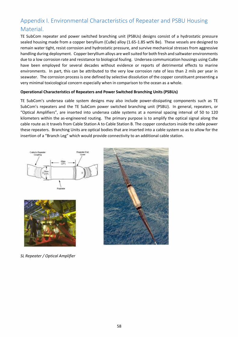
58
Appendix I. Environmental Characteristics of Repeater and PSBU Housing
Material. TE SubCom repeater and power switched branching unit (PSBUs) designs consist of a hydrostatic pressure
sealed housing made from a copper beryllium (CuBe) alloy (1.65-1.85 wt% Be). These vessels are designed to
remain water tight, resist corrosion and hydrostatic pressure, and survive mechanical stresses from aggressive
handling during deployment. Copper beryllium alloys are well suited for both fresh and saltwater environments
due to a low corrosion rate and resistance to biological fouling. Undersea communication housings using CuBe
have been employed for several decades without evidence or reports of detrimental effects to marine
environments. In part, this can be attributed to the very low corrosion rate of less than 2 mils per year in
seawater. The corrosion process is one defined by selective dissolution of the copper constituent presenting a
very minimal toxicological concern especially when in comparison to the ocean as a whole.
Operational Characteristics of Repeaters and Power Switched Branching Units (PSBUs)
TE SubCom’s undersea cable system designs may also include power-dissipating components such as TE
SubCom’s repeaters and the TE SubCom power switched branching unit (PSBU). In general, repeaters, or
“Optical Amplifiers”, are inserted into undersea cable systems at a nominal spacing interval of 50 to 120
kilometers within the as-engineered routing. The primary purpose is to amplify the optical signal along the
cable route as it travels from Cable Station A to Cable Station B. The copper conductors inside the cable power
these repeaters. Branching Units are optical bodies that are inserted into a cable system so as to allow for the
insertion of a “Branch Leg” which would provide connectivity to an additional cable station.
SL Repeater / Optical Amplifier

59
SL Power Switched Branching Unit
Evaluations of the maximum heat dissipation for these components are also addressed by consideration of
the maximum power ratings of the components.
The below table summarizes the maximum operating current and maximum heat dissipation for the TE
SubCom PSBU and the 4 amplifier pair repeater designs. The spacing of repeaters and branching units results
in only very localized heating and negligible environmental effect.
DC Current (Amps) Power Dissipation (Watts)
PSBU 1.6 max 148
Repeater, 4 amp pair 1.6 max 48
Power Dissipation of TE SubCom's PSBU and 4 Amp Pair Repeaters.