appendices - and building/built... · appendices prepared for wirral council by donald insall...
TRANSCRIPT

THURSTASTON CONSERVATION AREA APPRAISAL & MANAGEMENT PLAN
Donald Insall Associates Ltd Page 1 of 25
THURSTASTON CONSERVATION AREA APPRAISAL AND MANAGEMENT PLAN
APPENDICES Prepared for Wirral Council by Donald Insall Associates Ltd, 2007 – Wirral Council 2009
DONALD INSALL ASSOCIATES LTD, Bridgegate House, 5 Bridge Place, Chester, CH1 1SA Tel: 01244 350063 email: [email protected] web: www.insall-lon.co.uk

THURSTASTON CONSERVATION AREA APPRAISAL & MANAGEMENT PLAN
Donald Insall Associates Ltd Page 2 of 25
CONTENTS APPENDICES A - Historic Plans
1. Tithe Map (1830s) 2. 1870 OS Map 1870 3. 1890 OS Map 4. 1910 OS Map 5. 1930s OS Map 6. 1950s OS Map
B - Plan Showing Conservation Area Boundary and Listed Buildings C - Plan Showing Relative Ages of Buildings D - Plan Showing Contribution of Buildings to Character of Area E – Plan Showing Character Zones and Gazetteer F - Gazetteer

THURSTASTON CONSERVATION AREA APPRAISAL & MANAGEMENT PLAN
Donald Insall Associates Ltd Page 3 of 25
THURSTASTON CONSERVATION AREA APPRAISAL AND MANAGEMENT PLAN
APPENDIX A – HISTORIC MAPS – 1830 (TITHE MAP)
Donald Insall Associates Ltd, 2007 – Wirral Council 2009

THURSTASTON CONSERVATION AREA APPRAISAL & MANAGEMENT PLAN
Donald Insall Associates Ltd Page 4 of 25
THURSTASTON CONSERVATION AREA APPRAISAL AND MANAGEMENT PLAN
APPENDIX A – HISTORIC MAPS – 1870S
Donald Insall Associates Ltd, 2007 – Wirral Council 2009

THURSTASTON CONSERVATION AREA APPRAISAL & MANAGEMENT PLAN
Donald Insall Associates Ltd Page 5 of 25
THURSTASTON CONSERVATION AREA APPRAISAL AND MANAGEMENT PLAN
APPENDIX A – HISTORIC MAPS – 1890S
Donald Insall Associates Ltd, 2007 – Wirral Council 2009

THURSTASTON CONSERVATION AREA APPRAISAL & MANAGEMENT PLAN
Donald Insall Associates Ltd Page 6 of 25
THURSTASTON CONSERVATION AREA APPRAISAL AND MANAGEMENT PLAN
APPENDIX A – HISTORIC MAPS – 1910
Donald Insall Associates Ltd, 2007 – Wirral Council 2009

THURSTASTON CONSERVATION AREA APPRAISAL & MANAGEMENT PLAN
Donald Insall Associates Ltd Page 7 of 25
THURSTASTON CONSERVATION AREA APPRAISAL AND MANAGEMENT PLAN
APPENDIX A – HISTORIC MAPS – 1930S
Donald Insall Associates Ltd, 2007 – Wirral Council 2009

THURSTASTON CONSERVATION AREA APPRAISAL & MANAGEMENT PLAN
Donald Insall Associates Ltd Page 8 of 25
THURSTASTON CONSERVATION AREA APPRAISAL AND MANAGEMENT PLAN
APPENDIX A – HISTORIC MAPS – 1890S
Donald Insall Associates Ltd, 2007 – Wirral Council 2009

THURSTASTON CONSERVATION AREA APPRAISAL & MANAGEMENT PLAN
Donald Insall Associates Ltd Page 9 of 25
THURSTASTON CONSERVATION AREA APPRAISAL AND MANAGEMENT PLAN
APPENDIX B – PLAN SHOWING CONSERVATION AREA AND LISTED BUILDINGS
Donald Insall Associates Ltd, 2007 – Wirral Council 2009
TThhiiss mmaapp iiss bbaasseedd uuppoonn OOrrddnnaannccee SSuurrvveeyy mmaatteerriiaall wwii tthh tthhee ppeerrmmiissssiioonn ooff OOrrddnnaannccee SSuurrvveeyy oonn bbeehhaall ff ooff tthhee CCoonnttrrooll lleerr ooff HHeerr MMaajjeessttyy’’ss SSttaatt iioonneerryy OOffff iiccee ©© CCrroowwnn
ccooppyyrriigghhtt .. UUnnaauutthhoorriisseedd rreepprroodduucctt iioonn iinnffrr iinnggeess CCrroowwnn ccooppyyrriigghhtt aanndd mmaayy lleeaadd ttoo pprroosseeccuutt iioonn oorr cciivv ii ll pprroocceeeeddiinnggss.. ((LLiicceennccee nnuummbbeerr 110000001199880033)) ((PPuubbll iisshheedd 22000099))..

THURSTASTON CONSERVATION AREA APPRAISAL & MANAGEMENT PLAN
Donald Insall Associates Ltd Page 10 of 25
TThhiiss mmaapp iiss bbaasseedd uuppoonn OOrrddnnaannccee SSuurrvveeyy mmaatteerriiaall wwiitthh tthhee ppeerrmmiissssiioonn ooff OOrrddnnaannccee SSuurrvveeyy oonn bbeehhaall ff ooff tthhee CCoonnttrrooll lleerr ooff HHeerr MMaajjeessttyy’’ss SSttaatt iioonneerryy OOffff iiccee ©© CCrroowwnn ccooppyyrriigghhtt .. UUnnaauutthhoorriisseedd rreepprroodduucctt iioonn iinnffrr iinnggeess CCrroowwnn ccooppyyrriigghhtt aanndd mmaayy lleeaadd ttoo pprroosseeccuutt iioonn oorr cciivv ii ll pprroocceeeeddiinnggss.. ((LLiicceennccee nnuummbbeerr 110000001199880033)) ((PPuubbll iisshheedd 22000099))..
THURSTASTON CONSERVATION AREA APPRAISAL AND MANAGEMENT PLAN
APPENDIX C– PLAN SHOWING RELATIVE AGES OF BUILDINGS
Donald Insall Associates Ltd, 2007 – Wirral Council 2009
THURSTASTON CONSERVATION AREA APPRAISAL & MANAGEMENT PLAN
Donald Insall Associates Ltd Page 11 of 25
THURSTASTON CONSERVATION AREA APPRAISAL AND MANAGEMENT PLAN
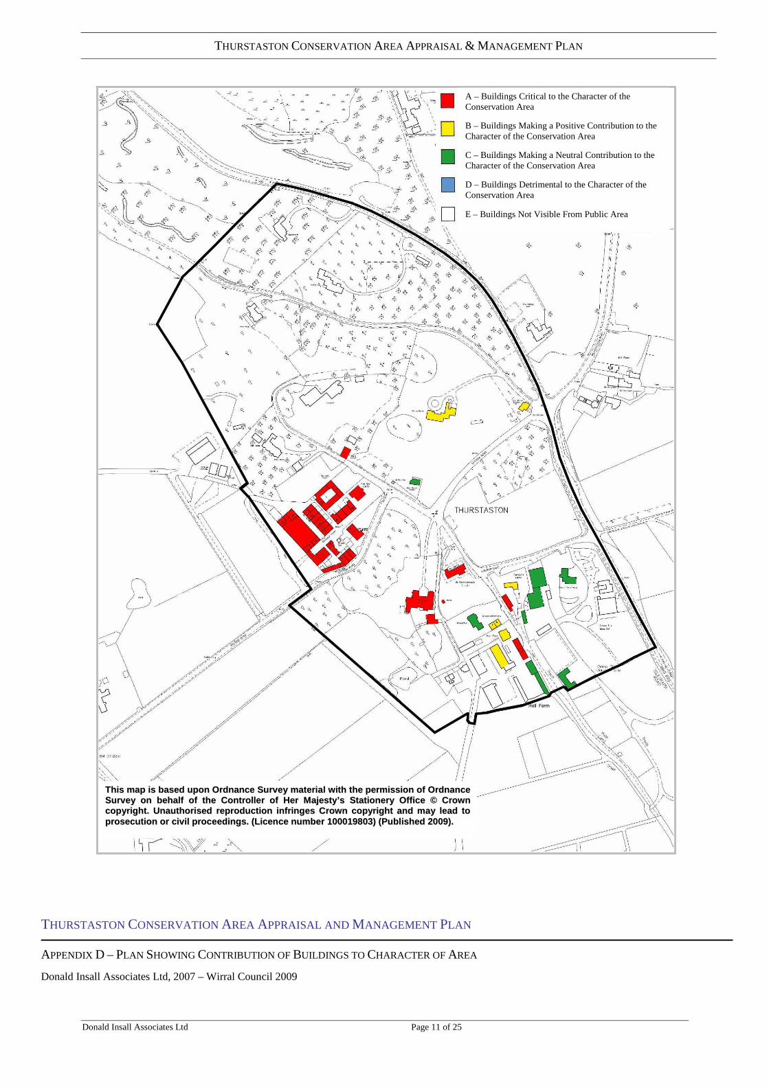
APPENDIX D – PLAN SHOWING CONTRIBUTION OF BUILDINGS TO CHARACTER OF AREA
Donald Insall Associates Ltd, 2007 – Wirral Council 2009
A – Buildings Critical to the Character of the Conservation Area B – Buildings Making a Positive Contribution to the Character of the Conservation Area C – Buildings Making a Neutral Contribution to the Character of the Conservation Area D – Buildings Detrimental to the Character of the Conservation Area
E – Buildings Not Visible From Public Area
TThhiiss mmaapp iiss bbaasseedd uuppoonn OOrrddnnaannccee SSuurrvveeyy mmaatteerriiaall wwiitthh tthhee ppeerrmmiissssiioonn ooff OOrrddnnaannccee SSuurrvveeyy oonn bbeehhaall ff ooff tthhee CCoonnttrrooll lleerr ooff HHeerr MMaajjeessttyy’’ss SSttaatt iioonneerryy OOffff iiccee ©© CCrroowwnn ccooppyyrriigghhtt .. UUnnaauutthhoorriisseedd rreepprroodduucctt iioonn iinnffrr iinnggeess CCrroowwnn ccooppyyrriigghhtt aanndd mmaayy lleeaadd ttoo pprroosseeccuutt iioonn oorr cciivv ii ll pprroocceeeeddiinnggss.. ((LLiicceennccee nnuummbbeerr 110000001199880033)) ((PPuubbll iisshheedd 22000099))..

THURSTASTON CONSERVATION AREA APPRAISAL & MANAGEMENT PLAN
Donald Insall Associates Ltd Page 12 of 25
THURSTASTON CONSERVATION AREA APPRAISAL AND MANAGEMENT PLAN
APPENDIX E – CHARACTER ZONES AND BUILDING GAZETTEER INDEX
Donald Insall Associates Ltd, 2007 – Wirral Council 2009
TThhiiss mmaapp iiss bbaasseedd uuppoonn OOrrddnnaannccee SSuurrvveeyy mmaatteerriiaall wwii tthh tthhee ppeerrmmiissssiioonn ooff OOrrddnnaannccee SSuurrvveeyy oonn bbeehhaall ff ooff tthhee CCoonnttrrooll lleerr ooff HHeerr MMaajjeessttyy’’ss SSttaatt iioonneerryy OOffff iiccee ©© CCrroowwnn ccooppyyrriigghhtt .. UUnnaauutthhoorriisseedd rreepprroodduucctt iioonn iinnffrr iinnggeess CCrroowwnn ccooppyyrriigghhtt aanndd mmaayy lleeaadd ttoo pprroosseeccuutt iioonn oorr cciivv ii ll pprroocceeeeddiinnggss.. ((LLiicceennccee nnuummbbeerr 110000001199880033)) ((PPuubbll iisshheedd 22000099))..

THURSTASTON CONSERVATION AREA APPRAISAL & MANAGEMENT PLAN
Donald Insall Associates Ltd Page 13 of 25
THURSTASTSON CONSERVATION AREA APPRAISAL APPENDIX F- GAZETTEER OF BUILDING DESCRIPTIONS Notes: The following documents is in the form of a Gazetteer of buildings within the
Conservation Area
No/Name: As identified from OS map Wirral UPRN: Space for Wirral Council’s unique referencing system Photograph: Buildings not visible from the public highway or groups of
recent buildings have not been photographed. Description: Brief summary Condition /Comment: All buildings in good condition unless otherwise noted. Contribution: Buildings are ranked in terms of their contribution to the
character of the conservation area:
A: (Red) – Buildings that are critical to the character of the area: typically these may be landmark buildings and / or historic buildings with most of their original character retained.
B: (Yellow) – Buildings that contribute positively to the character of the
conservation area: historic buildings may have some alterations but original character is still prominent.
C: (Green) – Neutral - Either modern buildings of little interest or buildings
where character has been lost beyond economic redemption. D: (Blue) – Buildings that detract from the significance or character of the area. E (No colour) Buildings not visible from a public area or right of way.
Post 1950 buildings and Conservation Character: In assessing the contribution of individual buildings, some difficulties arise in determining the extent to which more recent structures could be said to contribute to area character. The legislation (T&CP Act Listed Buildings and Conservation Areas) is concerned with safeguarding the historic environment. It defines conservation areas as ‘areas of special architectural or historic interest the character or appearance of which it is desirable to preserve or enhance’. PPG 15 advises that our experience of historic areas depends on a variety of factors including on the ‘appropriate scaling and detailing of contemporary buildings’ (4.2). Making judgements on the appropriateness of very recent buildings is often subjective. Their very newness may appear to clash with the historic environment but, over time, this may mellow and once innovative architectural ‘style’ become more generally accepted, even historic. In advance of the ‘test of time’, this appraisal takes a very cautious approach and ranks virtually all very recent buildings as neutral (other than those obviously of very poor design). The term ‘recent’ is applied to buildings post 1948. The status of ‘neutral’ buildings will, therefore,

THURSTASTON CONSERVATION AREA APPRAISAL & MANAGEMENT PLAN
Donald Insall Associates Ltd Page 14 of 25
require periodic review. (1948 is a ‘cut off’ date referred to in the Act in relation to curtilage structures deemed to be Listed by association with the main building.) Dating of buildings and sources: In undertaking this conservation area appraisal, age has been estimated on the basis of visual inspections from public areas only, map evidence (1844 Tithe map, OS maps from decades: 1870,1890,1930 and 1950s) and publications: The Hundred of Wirral, P Sulley, The History of Wirral, SJ Roberts and Wirral and its Viking Heritage, P Cavill, S Harding, J Jesch). Many buildings have been altered considerably over time and would require detailed study to fully interpret. The dates provided in the gazetteer, unless otherwise stated are approximate and relate to the original phase of construction or if that cannot be determined the most prominent parts. Unless clear documentary evidence is referred to, the periods ascribed to buildings should not be regarded as definitive. Where the original period of construction has been estimated, fabric from earlier various periods may exist. This is particularly true of vernacular buildings in ancient settlements where building facades can have been successively remodelled and roofs changed from thatch (universal before the later C18) to slate. Date stones cannot always be relied upon as they could have been incorporated into substantial rebuilding.

THURSTASTON CONSERVATION AREA APPRAISAL & MANAGEMENT PLAN
Donald Insall Associates Ltd Page 15 of 25
No. Name
WIRRAL UPRN
Photograph Description
Condition/ Comment (All structures appear in fair/good condition unless otherwise stated)
Contribution
Zone A 1 Thurstaston Hall: Listed grade II*, ancient
manor house, muliti period, late C17 façade to central range with some medieval fabric remaining in west wing (C15 or earlier). Mid C19 east wing (1836). Gate posts late C17 Listed separately Grade II.
Occupied as private house A
2 Barn (rear of Hall): Mid C19 gabled brick barn with slate roof, circular opening in gable.
Not publically accessible or viable from a public right of way.
A
3 St Bartholomew’s Church: Listed grade II church 1885 by J Loughborough Pearson RA, red sandstone with red clay tiled roof, in late C13 style ‘decorated’ with spire.
Constructed on site of former farm buildings adjacent to site of older church now demolished apart from tower.
A
4 Old Church Tower: Listed grade II square tower, remnant of church constructed in 1824, red sandstone with embattled top.
There is documentary record of a church at Thurstaston in 1125 (HoW p89). The 1824 church replaced an earlier building with semi circular chancel and bell turret.
A

THURSTASTON CONSERVATION AREA APPRAISAL & MANAGEMENT PLAN
Donald Insall Associates Ltd Page 16 of 25
5 Dawpool Cottages: Pair of semi detached cottages probably late C19 white rendered elevations below slate roof
B
6 Modern house west of Dawpool Cottages: Recent/Late C20 construction white rendered elevations below overhanging slate roof.
C
7 Sutton’s Farm Barns: Mid/Late C19 gabled stone barn, slate roof.
Appears to have same footprint as building shown on Tithe map c.1840.
A
8 Sutton’s Farm House: 2 storey white rendered elevations, recent casement windows, slate roof.
The ‘L’ shaped plan is as indicated on the Tithe map. Despite its ‘new’ appearance the building is likely to contain early C19/C18 fabric.
B

THURSTASTON CONSERVATION AREA APPRAISAL & MANAGEMENT PLAN
Donald Insall Associates Ltd Page 17 of 25
Zone B 1 Church Farm House: Late C20, 2 storey
house, rendered elevations below gabled slate roof, vernacular in style with sash window.
Residence forming part of development comprising, farm shop, mixed agricultural uses and caravan site.
C
2 Farm shop: Late C20/early C21 timber clad with bow roof (side view only visible from public right of way ).
Forms part of development comprising, farm shop, mixed agricultural uses and caravan site.
C
Various no number
Church Farm Outbuildings Forming part of development comprising, farm shop, mixed agricultural uses and caravan site. Not generally visible from public right of way.
E
Zone C 1 Hall Farm House: Late C19 2 storey
dwelling. The grey rendering may be a later application to brick elevations (note protruding brick string course). The building is shown on the 1890 OS.
B
2 Hall Farm Outer Barn: Late C19, fine brick barn on stone plinth and quoins with slate roof and full height central carriage opening.
Shown on the 1890 OS. A

THURSTASTON CONSERVATION AREA APPRAISAL & MANAGEMENT PLAN
Donald Insall Associates Ltd Page 18 of 25
3
Hall Farm Inner Barn Similar to ‘Outer Barn’ but only just visible from the public footpath.
B
4 Hall Farm Outbuilding: Mid C20 single storey agricultural building, pre cast frame, brick infill panels and profiled sheet roofing.
Fair/poor condition C
5 Hall Farm Outbuilding: Mid C20 low single storey timber clad agricultural buildings with profiled sheet roofing.
Fair/poor condition C
9 House Not visible from public right of way
E
10 Pair Semi Detached Houses Not visible from public right of way
E
Various no number
Hall Farm outbuildings Not visible from public right of way
E
Zone D 1 Old School House: Listed grade II, 1859
school in late medieval style, red sandstone elevations below steep slate roofs in late medieval style.
Ceased to function as school in 1906, now converted to dwelling. Late C20 extension to rear
A

THURSTASTON CONSERVATION AREA APPRAISAL & MANAGEMENT PLAN
Donald Insall Associates Ltd Page 19 of 25
2 Old Farm House Dawpool Farm: Listed grade II c1865. red sandstone elevations below steep pitched slate roof.
Part of the model farm constructed for James Hegan owner of 1st Dawpool house.
A
3 Dawpool Farm The Clock Tower Stables: Listed grade II, late medieval style agricultural buildings with clock tower over arched carriage entrance enclosing an inner yard c1882-4 by R.N. Shaw for Ismay family. A further development of Dawpool model farm commenced mid 1860s
Now in residential use A
4/10 Dawpool Farm Agricultural Buildings Listed grade II, (two separate Listings) part of model farm commenced mid 1860s.
Now in residential use. Some buildings not visible from public right of way.
A

THURSTASTON CONSERVATION AREA APPRAISAL & MANAGEMENT PLAN
Donald Insall Associates Ltd Page 20 of 25
Zone E 1 Lodge (A540) Late C19 gate lodge to the
second Dawpool House of 1884 (now demolished), low single storey, red sandstone below prominent red tiled roof.
Map evidence suggests lodge is contemporary with the re-routing of the A540 through the present cutting away from main house.
B
2 Bungalow. Mid C20 single small storey dwelling, brick elevations below slate roof with recent casement windows.
A dwelling has existed on this at least since the mid C19 Tithe map c 1840.
C
3 South Lodge: Listed grade II, Mid/Late
C19 two storey gate house. Red sandstone elevations in late medieval/ early C17 style below steep slate roofs.
The Listed Building description dates the building to the same period as the 2nd Dawpool House 1884 and the Gates bear the arms of the owners (Ismay). However, a lodge is also shown on the 1870 OS associated with the 1st Dawpool House 1858 and the style of this lodge would not be inconsistent at that date. Notably the lodge at the A540 entrance to the 2nd Dawpool House has a red tiled roof whereas this is slate.
A

THURSTASTON CONSERVATION AREA APPRAISAL & MANAGEMENT PLAN
Donald Insall Associates Ltd Page 21 of 25
4 Warren House 2 Storey pre WWII. Substantial house set in large private grounds.
B
5 Thor House Private 2 storey house post 1950
Substantial house set in large private grounds. Glimpse view from Station Road only
E
6 House Substantial house set in large private grounds. Not visible from public right of way
E
7 House Substantial house set in large private grounds. Not visible from public right of way
E
8 House Substantial house set in large private grounds. Not visible from public right of way
E
9 House Substantial house set in large private grounds. Not visible from public right of way
E
10 House Substantial house set in large private grounds. Not visible from public right of way
E

THURSTASTON CONSERVATION AREA APPRAISAL & MANAGEMENT PLAN
Donald Insall Associates Ltd Page 22 of 25
Listed Building Descriptions
WIRRAL CHURCH LANE SJ 28 SW (south side) Thurstaston 4/299 Church of St. Bartholomew 15.11.62 G.V. II Church. 1885.By J.Loughborough Pearson. Stone with tile roof. Nave, chancel with crossing tower and spire over choir and south vestry and organ loft. 3-bay nave has string course over base, sill course and continuous hood mould; cornice. West end has gabled angle buttresses; small buttress to north side. High 3-light west window has Geometrical tracery and sexfoil over; 2-light gabled and pinnacled blind windows flank head. 3-light windows with simple tracery to north and south. North gabled porch has angle buttresses and octagonal pinncles; Niche over entrance of 2 orders. Returns have 2 quatrefoils. Inner entrance has inscription recording building and dog-tooth moulding. Tower has gabled buttresses to north flanking 3-light window. Bell stage has louvred Y-tracery windows flanking buttresses; cornice, simple pinnacles and broach spire with louvred lucarnes. Round south-west turret with conical roof. Vestry has gabled buttresses and 2 lancets, swept cat-slide roof to extension to east. Pointed entrance has keel mould to jambs. 2-bay sanctuary has set-back buttresses and 5-light east window with flanking blind lancets and colonnettes, north and south blind arcade with 2 traceried lancets. Interior has quadripartite vaulting on corbelled wall shafts, that to chancel with dog-tooth moulding. Chancel and sanctuary arches. Stone chancel screen has traceried openings; pulpit is alabaster with pierced panels. Font of simple octagonal form, Mexican onyx on Blue John shafts and coloured marble steps. Organ case with painted panels, 1905, R.N. Shaw. Alabaster reredos, angles in niches and relief of resurrection. Sedillia to south. Good C19 stained glass. Queen Anne arms and dole cupboard of 1723. A good example of the work of J.L. Pearson.
WIRRAL CHURCH LANE SJ 28 SW (south side) Thurstaston 4/300 Tower of former church of St. Bartholomew approx. 3m. to south-west of 15.11.62 present church G.V. II Tower. 1824. Stone. Rectangular tower of 3 stages. 2 bands. Embattled parapet. Small window to west, rubble walling marking former nave to east has inserted plaque inscribed with names of church wardens and date. Round- headed bell openings have plain archivolts and are louvred.
WIRRAL CHURCH LANE SJ 28 SW (south side) Thurstaston 4/301 Sundial approx 4m. to south of St. Bartholomew's Church G.V. II Sundial. Dated 1844. Stone. Chamfered shaft on square steps. Brass plate, gnomon missing.
WIRRAL CHURCH LANE SJ 28 SW (south side) Thurstaston 4/302 Thurstaston Hall 15.11.62 G.V. II* House. West wing of C15 or possibly earlier,with gabled wing to west of 1680; main range of 1680; east range of 1836. Stone with brick to main range. 2 storeys, 3-bay centre. Stone base, vermiculated band over ground floor, cornice and top screen wall masking roof which has coping and finials, quoins and blind bull's eyes with vermiculated surrounds. Windows have gauged-brick flat arches and cross casements, those to 1st floor with leaded glazing. Entrance has bolection moulding, flanking Corinthian half-columns and broken pediment with Whitmore arms; half-glazed doors. Left wing has double-chamfered-mullioned windows, inner return has 3-light ground floor window and gabled half dormer, gable end has

THURSTASTON CONSERVATION AREA APPRAISAL & MANAGEMENT PLAN
Donald Insall Associates Ltd Page 23 of 25
rectangular bay window with sashed lights and 3-light window to 1st floor. Outer return has half dormers and lateral stack. Left wing has blocked pointed entrance to inner return with similar, partially obscured entrance to angle; corresponding blocked entrance inside hall. Gable end has sashed window with glazing bars to ground floor and pointed window with casement to 1st foor. Wing to west facade has datestone inscribed: "WWD/1680". Interior: Hall has bolection moulding to fireplace and re-used C16 overmantel with pilasters and arched panels. Stair has C16 spiral balusters and closed string with pulvinated frieze, 2 rooms with bolection-moulded panels. West wing has 2 collar trusses with cusped wind braces; room to rear possibly before C15. Wood statue in C17 dress, possibly Hugh Lupus, Cll Earl of Chester or John Whitmore, C14 Mayor of Chester.
WIRRAL CHURCH LANE SJ 28 SW (south side) Thurstaston 4/303 Gatepiers to north of Thurstaston Hall 15.11.62 G.V. II 2 gatepiers. Dated 1733. Stone. Fluted pilasters to all faces, entablatures with pulvinated friezes and small lion- head finials (Whitmore crest). South faces have simple niches with date panels over.
STATION ROAD SJ 28 SW (North Side) 4/309 Thurstaston Dawpool Farmhouse GV II Farmhouse now 4 flats. c1865. For James Hegan. Coursed, rock-faced red sandstone, graduated Welsh slate roof. 2 storeys and attic, 3 bays, twin wings to rear. Chamfered plinth, large quoins. Central 1-storey porch with low diagonal butresses flanking parallel double door under 2-centred arch and relieving arch; blind shield in recess beneath gable with ashlar copings. Window to left of porch has transomed 3-light casement in chamfered, quoined surround beneath relieving arch; similar 2-light window on right. 1st floor has 2-light windows as before. Dormer windows to bays 1 and 3 have ashlar surrounds and hipped roofs; glazed triangular vent to centre. Shaped kneelers and ashlar gable copings; finial to right end and offset end stack to left. Right return has centred, 1-storey bay window. Included for group value in relation to planned form buildings only
STATION ROAD SJ 28 SW (North Side) 4/307 Thurstaston Cattle Sheds incorporating smithy and implement shed at Dawpool Farm. GV II Cattle sheds incorporating smithy and implement shed. c1865. For James Hegan. Coursed, rock-faced red sandstone, graduated Welsh slate roofs. Irregular range of 1-storey buildings set round yard to south of 'Barn and Granary at Dawpool Farm' (q.v.) and attached to the barn by a 2-storey link; the implement shed forms the north-east side of the yard and beyond it projects a loose-box incorporating smithy workshop. 4-bay loose box has port-slatted casements in ashlar surrounds having rounded sills and chamfered quoins and lintels; smithy in additional end bay has boarded door on left of 4-pane window; rounded kneelers, ashlar gable copings, raised ridge with louvred side panels interspersed with glazed lights. Implement shed, adjoining at right angles, has 4-bay opening divided by iron posts; enclosed end bay with boarded double doors; plain roof with ashlar gable copings. Main cattle shed is of 4 bays with 3 square-headed doorways at north-east end having boarded doors and overlights in chamfered, quoined surrounds; part-slatted casements in openings as before; raised ridge. The south-west end of this building is linked by sturdy bull-pens to a row of individual pens with doorways as before under single roof with raised ridge. The 2-storey link to the barn has open-sided ground-floor to east beneath ashlar oculus with sill and hood flanked by small casements. Opposite side of link has square-

THURSTASTON CONSERVATION AREA APPRAISAL & MANAGEMENT PLAN
Donald Insall Associates Ltd Page 24 of 25
headed waggon entrance (on axis of main form drive). These buildings are listed for group value as part of a planned farm complex of which the barn/granary, dated 1862, are the most impressive element. The cattle sheds apart, to be of same date apart from the loose box which has rubble walling of later character facing Station Road; the implement shed may also be of same later date.
STATION ROAD SJ 28 SW (North Side) 4/306 25.03.81 Barn and Granary to (Granary) Dawpool Farm, to west of other building. II GV 19.5.86 shall be added to the item The description shall be amend to read; Barn and granary. Dated 'J.H. 1862'. For James Hegan. Coursed, rock-faced red sandstone, graduated Welsh slate roof. Barn in 9 x 5 bays under twin roof andis linked to shorter granary building by water tank and roofed canopy. West wallof barn has numerous ventilation slots whilst east side is open sided having lowplinth wall and tall piers dividing bays. Pointed arch beneath valley at southend. Granary gable to south has 2 squared-headed doorways with overlights set between slatted casements with rounded sills and chamfered quoined surrounds; 2 boarded doors to 1st floor and window beneath central plaque with 'J.H. 1862' in bold figures; rounded kneelers and ashlar gable copings. The east side has ashlar ventilation loops whilst west side has wide double doors, pointed doorways and windows as gable front. The watertank structure linking barn and granary is supported on corbelled iron beams and brick arches. An octagonal boiler-chimney rises from granary roof. Interior of barn: integral triangular buttresses; axial passage with flanking side walls supporting cast-iron columns which support tie beam and fishbone trusses. Southern bay forms coach-house and stable with casements, formerly leaded, flanking entrance, pitching holes to left. Stable has 2-bay stalls with chutes from left. The barn and granary form the main element of a planned form complex at Dawpool and are interesting examples of the mid-Victorian phase of agricultural building development.
WIRRAL STATION ROAD SJ 28 SW (north side) Thurstaston 4/305 The Clock Tower G.V. II Stables, now house. c.1882-4. By R.N. Shaw. Rock-faced stone with ashlar dressings, tile roof. 2 storeys, 6 bays. Double-chamfered-mullioned windows of 2 and 4 lights to ground floor, 1:3:2:1:3:3-light windows to 1st floor. Entrances to 2nd and 6th bays have flanking lights, that to 6th bay has Tudor head and label mould. Central pointed arch, the mouldings dying into jambs, with hood mould. Central 2-bay attic has cornice, embattled parapet and pyramidal roof; clock face. Cross-axial and gable-end stacks. Courtyard through arch has open shelter to western side.
WIRRAL STATION ROAD SJ 28 SW (north side) Thurstaston 4/304 Former Thurstaston School 25.03.81 G.V. II School. c.1858-9. Snecked stone with slate roof, now stripped (1985). One storey, 4 bays, the 1st bay of 2 storeys, projects under gable with porch and bell cote to right. Windows possibly originally mullioned, now with no frames due to restoration work. Weathered buttresses. 1st bay has window to ground floor with label mould taken over stone with foliate decoration and letter "N"; 1st floor window of 2 segmental-pointed lights, mullion. Porch has buttress to return, segmental-pointed entrance has hood mould with lozenge stops, door has elaborate hinges, lozenge over. Bell cote has corbelled cornice. Gable-end and 1st bay cross-axial stacks.

THURSTASTON CONSERVATION AREA APPRAISAL & MANAGEMENT PLAN
Donald Insall Associates Ltd Page 25 of 25
STATION ROAD SJ 28 SW (North Side, off) 4/310 Thurstaston South Lodge with attached gates and gate piers. GV II Lodge with attached gates and gate piers. Late C19. For the Ismay Estate. Tooled ashlar sandstone, shaped Welsh slate roof. L-shaped plan having entrance in wing to left set behind double gate; side gate against the lodge. 1 storey and attic; 2-bay front and left return. Chamfered plinth beneath two 2 -light mullioned windows having 2-pane sashes with diagonal glazing bars under linked hoodmoulds with ornate stops; half-dormer on right has similar window under gable with foiled panel, shaped kneelers and moulded gable copings. The end gables have similar copings; central ridge stack with 4 flues rising from deeply offset plinth. Left return (facing drive): triangular headed door under hoodmould stepped over blind shield; 3 - light windows on right and 2-light windows above in style of rest. Gate piers: plinths and monolithic shafts incorporating front buttresses beneath carved Liver Birds; cornices with ball finials. Iron gates have twisted bars and scrollwork. The Ismay family, of shipbuilding fame, purchased the Dawpool Estate in 1877 and built the main house (now demolished) to which this formed the principal entrance. Included for group value only.