an application of theos data to rubber plantation areas in
TRANSCRIPT

Proceedings of the 33rd Asia Pacific Advanced Network, February 13-17, 2012
An Application of THEOS Data to Rubber Plantation Areas in Mukdahan Province, Northeast Thailand.
SUWANWERAKAMTORN Rasamee1, PUTKLANG Wasana1, KHAMDAENG Pattaya1 and WANNAROS Pongtep2
1 Geo-informatics Centre for Development of Northeast Thailand, Faculty of Science, Khon Kaen University, Khon Kaen Thailand 40002 2 Regional Centre for Geo-Informatics and Space Technology, Northeast Thailand, Computer Centre, Khon Kaen University, Khon Kaen Thailand 40002
E-Mails: [email protected]; [email protected] th; [email protected]; [email protected]
* Geo-informatics Centre for Development of Northeast Thailand, Faculty of Science, Khon Kaen University, Khon Kaen Thailand 40002; Tel +6 643 202 742; Fax: +6 643 202 743
Abstract: A rapid expansion of rubber plantation areas in Northeast Thailand in the preceding 15 years has resulted from high return in combination with technologically feasible rubber tree growth in the areas. Spatial information on the rubber plantation areas can be effectively incorporated into land use planning and decision-making. The study aims to establish a spatial database of the rubber plantation areas with the different tree ages using THEOS data. Covering an area of approximately 4339 km2, Mukdahan province located in the Northeast is currently the area of study. THEOS panchromatic images acquired during the period 2009-2011 were used to identify the plantation areas. Through a process of on-screen digitizing for selected images, textures of the images were based on visual analysis. Using the textures, identification of different tree ages was possible, and distinct line spacing of rubber tree pattern could be observed. The panchromatic THEOS data is capable of identifying the rubber sapling by observation of plow line spacing (3m x 7m). We could classify the rubber tree into 3 classes of age: less than 5, 5-10 and over 10 years. The result indicated that areas planted to rubber trees accounted for roughly 11.21, 3.77 and 2.84 % for <5, 5-10 and > 10 years of plant ages respectively. The panchromatic THEOS data with 2m resolution proved to be effective in identifying the rubber tree ages.
Keywords: Rubber Plantation; Mukdahan Province; THEOS Data

1. Introduction
Natural rubber (Hevea brasiliensis Muell Arg, NR) is one of the most important economic crops in Thailand and its production has been the largest export volume in the world market [1]. The rubber plantation has been abundantly cultivated in the South of Thailand where climatic condition and land types are favorable. The plant proved to be successfully grown in Northeast Thailand since the past two decades with an attractive price resulting a large expansion of the plantation area. The plantation areas in the Northeast covered an area of approximately 447,873.44 ha, 477,455.52 ha and 532,232.96 ha in the years 2008, 2009 and 2010 respectively [2], [3], [4]. The OAE provided only statistics of the plantation areas in form of quantitative data and no spatial data available, this led to a difficulty in an extension for the plantation. Satellite data are widely accepted to map the plantation areas and to forecast the potential area suitable for the rubber tree. To achieve the objectives, effective inventories of the plantation areas in terms of spatial distribution and the tree ages are needed. [5] applied NDVI and tasseled cap transformation components of Landsat 5 TM to estimated the plantation area in the Northeast. The study reported successful use for the estimated of mature and middle-age rubber stands. [6] applied SPOT multispectral data and THEOS panchromatic data to estimate the plantation area and plant ages in the Northeast using on-screen digitizing procedure. The obtained results provided successful use of the SPOT data for the plantation areas of plant over 5 years and the young rubber tree of less than 5 years could be resolved by the THEOS panchromatic images. In addition this study could effectively differentiate and classify the rubber tree of different ages with a supplement of using rainfall, land form and soil data. Updated spatial information about the rubber plantation helps support the extension program of Thai government, granting over 40 million rubber saplings to farmers. Moreover, this is to maximize the use of THEOS data in strategic planning for the rubber plantation after the successful launch of the THEOS. The study thus aims to estimate the areas planted to the rubber tree of different ages, based on the THEOS panchromatic data, focusing accurate and practical application.
2. Study area
The study area, Mukdahan province, covering an area of approximately 440 thousand ha. is located in Northeast Thailand on the Thai-Lao PDR border (figure 1). The strong topography in the west of the province and gently undulating land with flood plain in the east characterize the study area. The area is underlain by Mesozoic rock of Phu Kradung, Phra Wihan, Sao Khua, Phu Phan, and Khok Krut geologic Formation. Land use is restricted to dry dipterocarp, mixed deciduous and evergreen forest types on the mountain areas and to rubber tree, cassava, sugar cane, and paddy rice on the gently undulating topography. The area is drained eastward to the

Mekong by Huai Chanot, Huai Bang Sai, Huai Muk and Huai Bang I rivers. The mean annual rainfall in the area approaches 1500 m.m. over 60 % of which fall in August and September.
Figure 1. Study area, Mukdahan province, Northeast Thailand
3. Methods
The procedures in this study comprised an estimate of the rubber plantation areas using the THEOS panchromatic data. Identification of the rubber plantation areas was based on visual analysis of the images using on screen digitizing. The method included preprocessing of data, image analysis and validation (figure 2)
3.1. Data Sources
- THEOS panchromatic data used in this study consisted of 19 scenes in the year 2009- 2011 (Table 1)
- Aerial Orthophotograph acquired in 2002 - Topographic maps (1:50,000) of the Royal Thai Survey Department - Land use map in 2002
3.2. Preprocessing of the THEOS data
The THEOS data was geometrically corrected, transforming the images coordinates using image to the aerial orthophotograph. A resampling of the pixel with nearest neighbor algorithm was performed. The corrected THEOS images, digitally enhanced were used in the analysis process for identifying rubber plantation areas.
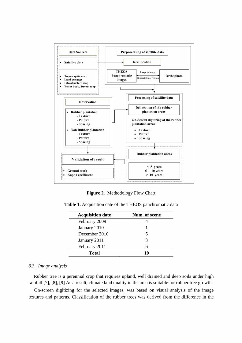
Figure 2. Methodology Flow Chart
Table 1. Acquisition date of the THEOS panchromatic data
Acquisition date Num. of scene February 2009 4 January 2010 1 December 2010 5 January 2011 3 February 2011 6
Total 19 3.3. Image analysis
Rubber tree is a perennial crop that requires upland, well drained and deep soils under high rainfall [7], [8], [9] As a result, climate land quality in the area is suitable for rubber tree growth.
On-screen digitizing for the selected images, was based on visual analysis of the image textures and patterns. Classification of the rubber trees was derived from the difference in the

cover gray tones and patterns, resulting 3 classes of the tree ages : <5, 5-10 and over 10 years. Identification of different tree ages could be digitized by a distinct plant canopy, high and moderate canopy for the mature ages, and incomplete cover of spacing 3m x 7m for less than 5 year ages. As a result, the young rubber could be resolved and identified using the panchromatic THEOS data.
3.4 Validation and field investigation
The ground survey provides details of establishing the relationship between image feature and rubber covers as well as site characteristics. To achieve the objective this approach used a number of replications for each class and allocated the sampling site by GPS. Over 25 locational samples sites of the different plant ages with various landforms and soil types were investigated. Observation records at each site included cover types and their composition, landform, topography, soil and other land characteristics. An estimate of a rubber stand and the land characteristics were carried out to ensure the observation together with information on land use, landform and soil maps. The obtained map was checked against the ground truth. Kappa coefficient was applied to determine an agreement between the obtained maps and the ground truth.
4. Results
4.1 Rubber plantation areas and its distribution
The plantation areas and its distribution, based on the THEOS panchromatic data, are shown in Table 2 and Figure 3. The total areas accounted for 78,467.00 ha, representing 17.82 % of the entire province. Of the total plantation areas, the young rubbers (<5 years old) occupied about 11.21 %, some of which have been intercropped with annual crops (cassava, pineapple). It was noted that the age of rubber plantation could yield significantly in variation of spectral reflectance. The younger rubber plantation found in the province resulted from one or mixed surface covers of rubber canopy, inter-croppings, weed, sparse native trees and bare soil (figure
4). The accuracy in identification of the young rubber plantation was highly reliable when using THEOS panchromatic data. The THEOS panchromatic data could resolve the pattern of the young rubber plantation which has mostly the planted spacing of 3m. x 7m. The mature rubber plantation could be resolved or identified by dense plant canopy which can be easily observed when using THEOS panchromatic data (figure 5 and figure 6).
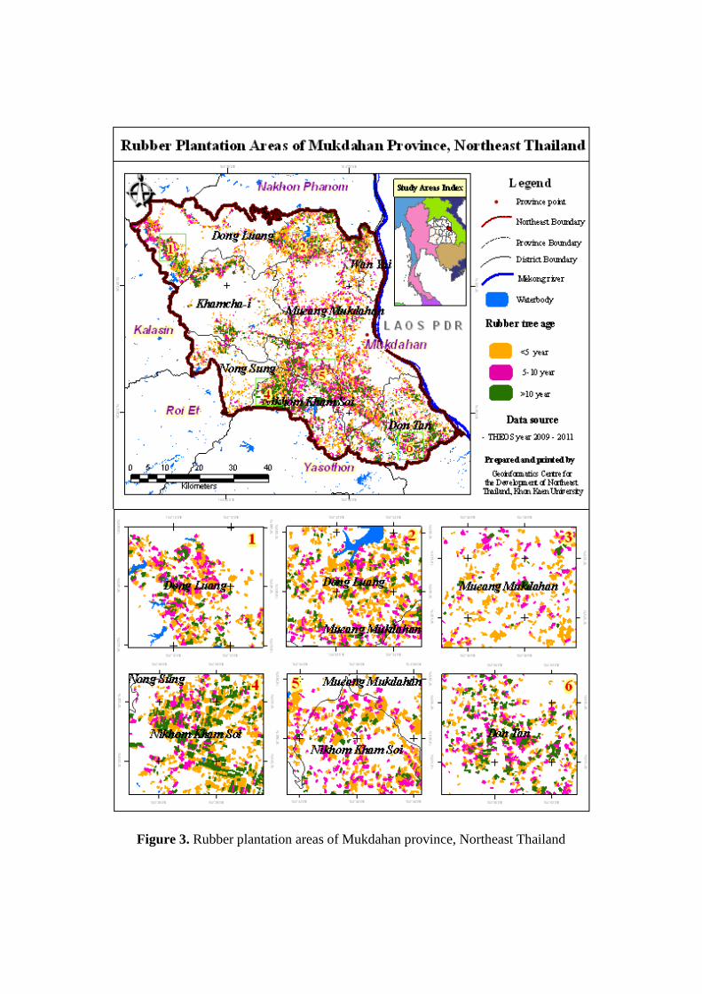
Figure 3. Rubber plantation areas of Mukdahan province, Northeast Thailand
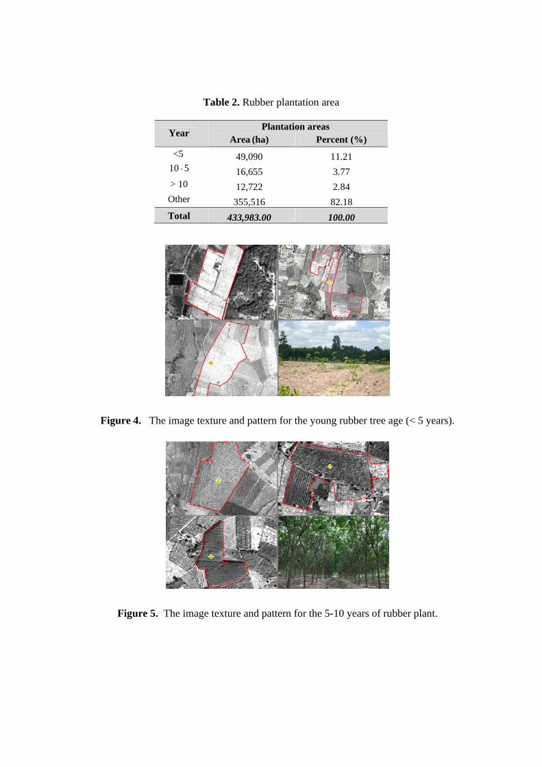
Table 2. Rubber plantation area
Year Plantation areas
Area (ha) Percent (%)
< 5 49,090 11.21 5 - 10 16,655 3.77
> 10 12,722 2.84 Other 355,516 82.18 Total 433,983.00 100.00
Figure 4. The image texture and pattern for the young rubber tree age (< 5 years).
Figure 5. The image texture and pattern for the 5-10 years of rubber plant.
Figure 6. The image textures and patterns of the mature ages (> 10 years) of rubber plant.
4.2 Validation
To assess the reliability of the resultant map the results were checked against the ground investigation. The ground investigation of the plantation areas of 25 locations was based on the current plantation area (2010) with estimate of the plant ages back to the date of data acquisition. The Kappa coefficient of the obtained result and ground truth is 0.75. The confusion between the ground survey and the obtained map is shown in table 3. However it would suggest caution in using maps and the statistics provided. The users should take into account the acquisition dates of satellite data.
Table 3. The confusion between the ground survey and the obtained map
Image
Classify Survey
User’s accuracy (%) < 5 5-10 >10 Total <5 8 1 0 9 0.88
5-10 2 7 0 9 0.77 >10 0 1 6 7 0.85
Total 10 9 6 25 Producer’s accuracy (%) 0.80 0.77 1.00
4. Conclusions
The THEOS panchromatic data with 2 m. resolution is capable of identifying and resolving the different rubber plant ages with relatively higher accuracy. This study provided both spatial and quantitative information on the rubber plantation areas that can be used for formulating strategic policy planning in rubber export and extension. The marketing risk could be minimized

if the planning policy is implemented with obtained information. With availability of the rubber plantation areas in a form of GIS database, a systematic analysis of formulating land use planning in the province will be comprehensive and effective. To minimize the time required in identifying the plantation areas, complete digital image processing should be further investigated.
Acknowledgements
This work was supported by GISTDA for satellite data. We deeply appreciate Dr. Charat Mongkolsawat for helpful advice and manuscript editing.
References 1. Sombatsompop N., Markpin T., Wimolmala E., Ratchatahirun P., Premkamolnetr N.,
Boonradsamee B., and Yochai W. Relationship on research publications and productivity-export volumes for natural rubber. Scientometrics 2009, 81, 393-405.
2. Office of Agricultural Economics. Agricultural Statistics of Thailand 2008. Agriculture Statistics No. 404. Center for Agricultural Information, Office of Agricultural Economics: Bangkok, Thailand, 2008; pp. 88-91. [in Thai.]
3. Office of Agricultural Economics. Agricultural Statistics of Thailand 2009. Agriculture Statistics No. 401. Center for Agricultural Information, Office of Agricultural Economics: Bangkok, Thailand, 2009; pp. 78-81. [in Thai.]
4. Office of Agricultural Economics. Agricultural Statistics of Thailand 2010. Agriculture Statistics No. 416. Center for Agricultural Information, Office of Agricultural Economics: Bangkok, Thailand, 2010; pp. 78-81. [in Thai.]
5. Li, Z.; Fox, J.M. Rubber Tree Distribution Mapping in Northeast Thailand. Geosciences 2011, 2, 573-584.
6. Monkolsawat, C; Putklang, W. An approach for Estimating area of rubber plantation: Integrating satellite and physical data over the Northeast Thailand. Proceedings of the 31th Asian Conference on Remote Sensing Vietnam. 1-5 November 2010. Hanoi, Vietnam.
7. Department of Agriculture. Rubber tree, Technical paper No.12/2004. The Agriculture Co-operative Federation of Thailand: Bangkok, Thailand, 2008; pp. 22-24. [in Thai.]
8. Land Development Department. Technical paper of Rubber tree. Office of Land Management Research and Development, Land Development Department: Bangkok, Thailand, 2008; pp. 29-31 [in Thai.]

9. Watson, G.A. Climate and soil. In Rubber, Webster, C.C. and Baulkwill, W.J. Eds.; Tropical Agriculture Series, Longman Scientific and Technical, Singapore, 1989; pp. 125-163.
© 2012 by the authors; licensee Asia Pacific Advanced Network. This article is an open-access article distributed under the terms and conditions of the Creative Commons Attribution license (http://creativecommons.org/licenses/by/3.0/).