amsterdam avenue 110 st to 155 st - new york city
TRANSCRIPT

AMSTERDAM AVENUE 110TH ST TO 155TH ST
Safety Improvements
Presented to Manhattan Community Board 9 Transportation Committee
December 7, 2017

PRESENTATION OVERVIEW
Amsterdam Avenue Safety Improvements
RECAP New Parking Information
Summary
Previously Presented (Optional): Background
Project Location
Safety
Key Issues
ProposalCorridor Redesign
Intersection Improvements
Making It Work
Summary
Columbia
University
Columbia
University
City College
Of New York
RiverbankState Park

Amsterdam Looking North at West 112th
KEY ISSUES – Corridor Safety, Vision Zero
RECAP
Injury SummaryFatalities & Serious Injuries 4 Pedestrian Fatalities
(2010-2016)
28 Pedestrians Severely Injured (2010-
2014)
8 Cyclists Severely Injured (2010-14)
Off-Peak Speeding70% of vehicles travel above the speed
limit during off peak time*
*Speed Study: 136th -138th St mid-day 1/27/17
Lack of Commercial Loading /
Excessive Double Parking
No Dedicated Space for Bikes 805 Cyclists (12h count 10/3/17)
Safety Issues Mobility Issues
Speeding through TurnsWide Turning Radii at Intersections
Peak Hour Traffic Congestion
Weaving / Lane Shopping
Long Pedestrian Crossings

PROPOSED IMPROVEMENTS AND SAFETY BENEFITS
RECAP
The proposed project will increase safety for everyone on the street
while maintaining parking and minimally affecting travel times for drivers
Turn Bayscreate simpler, safer left
turns, reduce back pressure
Narrower Roadway discourages speeding
Bike Lanesprovide dedicated space for
cyclists, increase
predictability
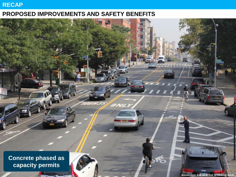
RECAP
Vanderbilt Ave, BK
Concrete phased as
capacity permits
PROPOSED IMPROVEMENTS AND SAFETY BENEFITS
Amsterdam Ave at 172nd St looking north

PROJECT EVOLUTION
RECAP
Additional
Data
Collection /
Analysis,
Presented
Conceptual
Changes
Present
Details of
Revised
Design
Initial
Corridor
Design
FEEDBACK
Revised Proposal with Additional Vehicular Capacity
(135th – 145th )
FEEDBACK
Detail Loading
Zones & Metered
Parking Plan
Added Vehicular
Capacity

Bronx
MAKING IT WORK – Loading Zones
New Parking Information
Add 20 unmetered truck loading zones (7am-1pm Mon to Fri)
Add unmetered truck loading zones (7am-1pm Mon to Fri)
& 8 new 2 hour metered parking (1pm-7pm Mon to Fri)
Reduce likelihood of trucks
double-parking during peak
travel times
Note 1: Existing metered parking to
remain unless otherwise indicated.
Note 2: Truck loading zones will be
approx 60’ long.
DRAFT

Amsterdam Looking North at West 187th
SUMMARY OF BENEFITS – Corridor Safety, Vision Zero
SUMMARY
Narrowed Travel Lanes Reduces Speeding
Painted Curb Extensions /
Phased Pedestrian
Refuge IslandsShortens Pedestrian Crossings
Bike LanesServing Residents & Local Restaurants
Safety
Improvements
Mobility
Improvements
Tighter Turning Radii /
Hardened Center Lines Slows Turns
Traffic Flow EnhancementsLeft Turn Bays, Signal Adjustments,
Rush Hour Lanes
Expanded Loading Zones &
Metered ParkingReduces Double Parking, Increases
Effective Capacity
Better Organized Roadway Reduces Lane Shopping

Questions?
THANK YOU!
NYCDOT nyc_dot nyc_dot NYCDOT

1Background

Background
11
PROJECT LOCATION AND COMMUNITY REQUESTS
Columbia
University
RiverbankState Park
City College
Of New York
1. Amsterdam Ave W 110th – W 155th St
2. Corridor Characteristics
• Mix of high density residential and
commercial
• Columbia University
• City College
3. Senior Safety Area
• Hamilton Heights Senior Safety Area
W 145th St – W 155th St
4. Community Requests
• Request from CM Levine to address
safety concerns between 110th St and
125th St
• Add metered parking around 140th
• Additional north/south bike route
5. Citi Bike
• Phase II expansion underway

Background
SAFETY – Vision Zero
Multi-agency effort to reduce
traffic deaths and injuries
through improved
• Engineering
• Education
• Enforcement
Priority Intersections
on Amsterdam Ave at
• W 125th St
• W 133rd St

Total
Injuries
Severe
InjuriesFatalities KSI
Pedestrian 246 25 3 28
Bicyclists 69 8 0 8
Motor Vehicle
Occupant445 23 0 23
Total 760 56 3 59
Fatalities, 01/01/2010 – 01/09/2016: 4
Source: Fatalities: NYCDOT, Injuries: NYSDOT. KSI: Persons Killed or Severely Injured
SAFETY – Project Area
Injury Summary, 2010-2014 (5 years)
Background
4 Pedestrian Fatalities 2010-2016
(112th , 113th , 122nd , 155th)
28 Pedestrians Severely Injured 2010-2014
8 Cyclists Severely Injured 2010-2014

Amsterdam Looking North at West 112th
KEY ISSUES– Corridor Safety
Background
*Speeding (136th -138th St mid-day)
71% Above 25mph (NB)
70% Above 25mph (SB)
Undefined Lane
Assignmentslead to unpredictable
vehicular movements
Off-peak Speeding70% of vehicles travel
above the speed limit
during off peak time*
No Dedicated Space
for Bikes cyclists ride with traffic,
less predictable locations

Amsterdam Looking West at West 133rd
KEY ISSUES – Intersection Safety
Background
Poor Alignmentcreates driver confusion,
long pedestrian crossings
Wide Roadwaycreates long pedestrian
crossings
Wide Turn Radiienable drivers to take turns
at high speeds, cut corners

Amsterdam Looking North at West 112th
KEY ISSUES – Bike Network Connectivity
Background
Columbia
University
RiverbankState Park
City College
Of New York
1. Gap in Network
2. Broadway
• North/South route requested in 2015
• Amsterdam Ave preferred alternative
3. No Connection to Existing Bike Lanes
• Amsterdam Ave north of 160th St
• Amsterdam Ave (NB ends at 110th)
• Columbus Ave (SB begins at 110th)
• Hudson River Greenway
4. Cyclist Volumes
• W 113th – W 114th St • Weekday 12hr: 805
• Weekend 12hr: 767
• W 142nd – W 143rd St • Weekday 12hr: 490
• Weekend 12hr: 248
**Bike counts done on 10/3 and 10/8/2017

3Amsterdam Ave
Proposal

PROJECT OVERVIEW
Proposal
1. Corridor Redesign
4–to-3 lane conversion with
left turn lanes and bike lanes
2. Intersection Improvements
• Pedestrian Refuge Islands
• Painted Curb Extensions
3. Making it Work
• Traffic Analysis
• Transitions
• Rush Hour Regulations
• Loading Zones
Columbia
University
RiverbankState Park
City College
Of New York

1. CORRIDOR REDESIGN – Existing Conditions (Typical)
Proposal
• 60 ft wide• 2 moving lanes in each direction• Parking on both curbs
No Dedicated Space
for Bikes cyclists ride with traffic,
less predictable locations
Undefined Lane
Assignmentslead to unpredictable
vehicular movements
Off-peak Speeding70% of vehicles travel
above the speed limit
during off peak time*

1. CORRIDOR REDESIGN – Proposed Design (Typical)
Proposal
• Remove one travel lane in each direction• Install left turn bays• Install bike lanes in both directions• Maintain parking on both curbs
Turn Bayscreate simpler, safer left
turns, reduce back pressure
Narrower Roadway discourages speeding
Bike Lanesprovide dedicated space for
cyclists, increase
predictability

1. CORRIDOR REDESIGN – Example of Proposed Design
Proposal
Left Turn Baysorganize traffic and
create safer left turns
Maintain Consistent
Moving Lanereduces speeding, reduce
conflict
Amsterdam Ave at 172nd St looking north

1. CORRIDOR REDESIGN – Safety Benefits of Left Turn Bays
Proposal
Motorists traveling thru get stuck behind left turning vehicles and weave or mergeinto right lane
Left turn movements are challenging because motorists:
• Feel back pressure from vehicles wanting to go thru while trying to turn
• Must identify a gap in two lanes, poor visibility for second lane
• Must look for pedestrians in crosswalk
Left turn movements are simplified because motorists:
• Feel less back pressure since no thru motorists are stuck behind them
• Only have to look for gap in one lane of motor vehicle traffic
• Find it easier to focus on pedestrians in crosswalk
Motorists traveling thru are already in the correct position, resulting in less weaving and merging, which improves safety and traffic flow
Motorists turn less aggressively, reducing the risk of injury for all road users

1. CORRIDOR REDESIGN – Safety Benefits of Left Turn Bays
Proposal
Before and after analysis of left turn
bays installed at 140 intersections
(2009-2011):
• -45% Left turn motor vehicle
occupant injuries
• -25% Total motor vehicle
occupant injuries
• -24% Left turn pedestrian injuries
• -9% Total pedestrian injuries
Injuries on Two-Way Approaches with Left Turn Bays
Motor Vehicle
Left Total Injury
Before (3 Years) 350 1,137
After (3 Years) 191 850
Change -45% -25%
Pedestrian
Left Total Injury
Before (3 Years) 107 284
After (3 Years) 81 259
Change -24% -9%
Left turn bays improve traffic organization by allowing left
turning vehicles their own space before turning left, which helps
reduce back pressure from other vehicles

2. INTERSECTION IMPROVEMENTS – Pedestrian Refuge Islands
Proposal
Wide Roadwaycreates long pedestrian
crossings
Wide Turn Radiienable drivers to take turns
at high speeds, cut corners

2. INTERSECTION IMPROVEMENTS – Pedestrian Refuge Islands
Proposal
Pedestrian Refuge
Islands*create safer crossings
forces slower left-turns
10 Prioritized
Locations
* Islands will be flush medians until capital construction*
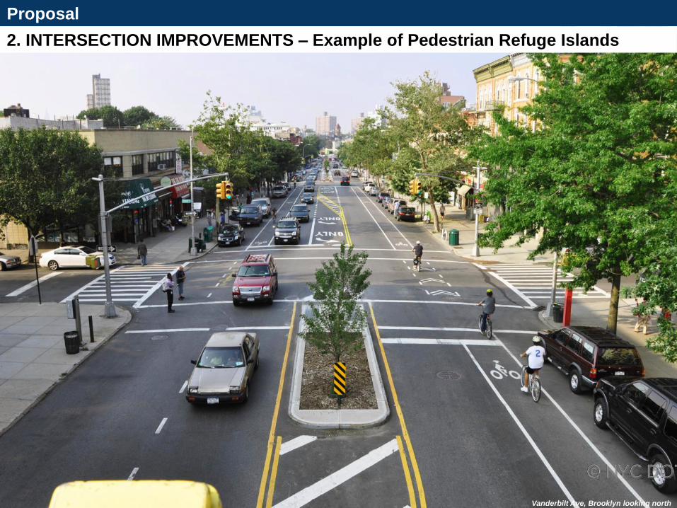
Proposal
Vanderbilt Ave, BK2. INTERSECTION IMPROVEMENTS – Example of Pedestrian Refuge Islands
Vanderbilt Ave, Brooklyn looking north

Proposal
2. INTERSECTION IMPROVEMENTS – Painted Curb Extensions
Poor Alignmentcreates driver confusion,
long pedestrian crossings

Proposal
2. INTERSECTION IMPROVEMENTS – Painted Curb Extensions
Painted Curb Extensionimproves alignment,
creates safer turns,
shortens pedestrian crossing,
improves visibility

3. MAKING IT WORK – Traffic Analysis (PM)
Proposal
29
Columbia
University
RiverbankState Park
City College
Of New York
* Peak hours vary per intersection*
W 110: v/c – 0.79
Proposed Condition Max v/c Ratios
W 125: v/c – 1.07
W 135: v/c – 0.82
W 145: v/c - 0.69
W 155: v/c - 0.69
Cross Street
Overall Intersection Delay (sec) /LOS
Max Volume-to-Capacity Ratio
Existing ProposedExisting Proposed
Delay LOS Delay LOS
W 110th St 25.0 C 24.8 C 0.79 0.79
W 125th St 35.3 D 39.0 D 1.07 1.07
W 135th St 11.1 B 15.5 B 0.66 0.82
W 145th St 10.3 B 11.8 B 0.62 0.69
W 155th St 19.5 B 22.0 C 0.65 0.69
Minimal impact on traffic • Delay at all intersections increases by an
average of less than 3 seconds• Sufficient or same capacity maintained at all
intersections

3. MAKING IT WORK – Southern Transition (110th St - 113th St)
Proposal
• Maintains capacity at high volume location to ensure traffic flow• One lane SB from 113th St - 111th St, Two lanes NB from 110th St – 113th St
Proposed

3. MAKING IT WORK – (135th St - 145th St)
Proposal
• Maintains capacity at high volume location to ensure traffic flow• One lane SB, Two lanes NB from 135th St – 145th St
Proposed

3. MAKING IT WORK – 125th St
Proposal
• Maintains capacity at high volume location to ensure traffic flow• Continues one lane SB
Existing
Proposed

3. MAKING IT WORK – Rush Hour Regulations at 145th St, 155th St
Proposal
• Increases capacity at high volume locations to maintain traffic flow• Eastern parking lane will turn into travel lane during PM peak hours
• Standard parking at all other times
Existing
Proposed

3. MAKING IT WORK – Loading Zones
Proposal
• Improve access to the curb for commercial deliveries• Targeted loading zones address varied needs block by block• Extensive business outreach with surveys
Loading Zonesallows curbside access,
reduces double parking,
ensures traffic flow
Bronx

3. MAKING IT WORK – Loading Zones (Public Outreach)
Proposal
Bronx
Merchant Surveys
• 12 question survey
• Number of deliveries
• Time of day
• Length of drop off
• Vehicle type
• 124 surveys completed
Survey Initial Takeaways
• Double parking is a serious concern
• Drivers constantly receiving tickets for
double parking
• General support for dedicated commercial
loading zones
• Most managers/ owners seemed welcome
to any street improvements
• Many restaurants rely on delivery cyclists
Ambassadors attempted to survey
every business along project corridor
April 24th and April 26th

3. MAKING IT WORK – Loading Zones (Proposal)
Proposal
Bronx
Reduce the likelihood of trucks
double-parking during peak
travel times
Note 1: Existing metered parking to remain unless otherwise indicated.Note 2: Truck loading zones will be approx 60’ long.
Add unmetered truck loading zones (7am-1pm Mon to Fri)
Add unmetered truck loading zones (7am-1pm Mon to Fri)& NEW 2 hour metered parking (1pm-7pm Mon to Fri)

3SUMMARY

PROPOSED IMPROVEMENTS AND SAFETY BENEFITS
Summary
The proposed project will increase safety for all road users along a corridor that had 4 pedestrian fatalities, 28 pedestrians and 8
cyclists severely injured between 2010 and 2014
Turn Bayscreate simpler, safer left
turns, reduce back pressure
Narrower Roadway discourages speeding
Bike Lanesprovide dedicated space for
cyclists, increase
predictability

nyc.gov/dot
Questions?
THANK YOU!
NYCDOT nyc_dot nyc_dot NYCDOT

Appendix
Intersections with more than 10 Injuries 2010-2014