amendment instrument planning scheme policies ...amendment instrument planning scheme policies ......
TRANSCRIPT

Amendment Instrument
Planning Scheme Policies (Administrative and Minor Amendment) No. 3
Made under the Sustainable Planning Act 2009, section 117 (Process for preparing, making or amending local planning instruments) This amendment has effect on and from 3 August 2015

Planning Scheme Policies (Administrative and Minor Amendment) No. 3 Page 1
1. Short title
This amendment instrument may be cited as Planning Scheme Policies (Administrative and Minor Amendment) No. 3.
2. Commencement
This amendment instrument has effect on and from 3 August 2015.
3. Purpose
The purpose of this amendment instrument is to address a small number of minor editorial and operational matters that require correction or changes to improve the clarity and efficiency of the following planning scheme policies:-
Planning scheme policy for the flood hazard overlay code;
Planning scheme policy for development works; and
Planning scheme policy for the transport and parking code.
This amendment instrument amends the component of the Sunshine Coast Planning Scheme 2014 in Table 1, Column 1, in respect of the provisions stated in Table 1, Column 2, in the manner stated in Table 1, Column 3.
Table 1 Amendment table
Column 1 Column 2 Column 3
Planning scheme policy component
Planning scheme policy provision
Amendment
Schedule 6 (Planning scheme policies), SC6.9 (Planning scheme policy for the flood hazard overlay code)
Section SC6.9.3 (Advice for floodplain protection, flood and storm tide inundation immunity and safety, building design and built form, essential network infrastructure, essential community infrastructure, hazardous and other material and flood impacts outcomes)
Amend as shown in Appendix A
Schedule 6 (Planning scheme policies), SC6.9 (Planning scheme policy for the flood hazard overlay code)
Section SC6.9.6 (Guidelines for achieving Flood hazard overlay code outcomes)
Amend as shown in Appendix A
Schedule 6 (Planning scheme policies), SC6.14 (Planning scheme policy for development works)
Section SC6.14.1.5 (Life cycle costs and life cycle management plans), Table 6.14.1A (Life cycle expenditure categories)
Amend as shown in Appendix A
Schedule 6 (Planning scheme policies), SC6.14 (Planning scheme policy for development works)
Section SC6.14.3.3 (Design requirements)
Amend as shown in Appendix A
Schedule 6 (Planning scheme policies), SC6.14 (Planning scheme policy for development works)
Section SC6.14.3.4 (Development design) and Figure SC6.14.3B (Inter-allotment stormwater locations)
Amend and renumber as shown in Appendix A

Planning Scheme Policies (Administrative and Minor Amendment) No. 3 Page 2
Column 1 Column 2 Column 3
Planning scheme policy component
Planning scheme policy provision
Amendment
Schedule 6 (Planning scheme policies), SC6.14 (Planning scheme policy for development works)
Section SC6.14.3.5 (Design requirements – stormwater drainage)
Amend as shown in Appendix A
Schedule 6 (Planning scheme policies), SC6.14 (Planning scheme policy for development works)
Section SC6.14.3.7 (Design requirements – stormwater quality), Table SC6.14.3G (Triggers for application of stormwater quality design objectives)
Amend as shown in Appendix A
Schedule 6 (Planning scheme policies), SC6.14 (Planning scheme policy for development works)
Section SC6.14.3.9 (Stormwater management plans), Table SC6.14.3H (C10 vs development category)
Amend as shown in Appendix A
Schedule 6 (Planning scheme policies), SC6.14 (Planning scheme policy for development works)
Section SC6.14.4.3 (Standard drawings), Table SC6.14.4A (WSAA drawing numbers)
Amend as shown in Appendix A
Schedule 6 (Planning scheme policies), SC6.17 (Planning scheme policy for the transport and parking code)
Section SC6.17.4 (Advice for achieving transport network outcomes), Table SC6.17B (Urban transport corridors)
Amend as shown in Appendix A
Schedule 6 (Planning scheme policies), SC6.17 (Planning scheme policy for the transport and parking code)
Appendix SC6.17A (Typical street and road cross sections)
Amend as shown in Appendix A
Sunshine Coast Planning Scheme 2014 Amended 3 August 2015 Page SC6-49
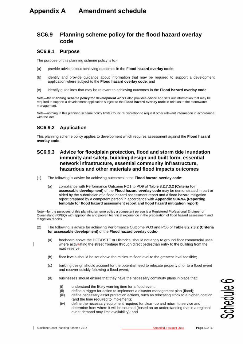
SC6.9 Planning scheme policy for the flood hazard overlay code
SC6.9.1 Purpose
The purpose of this planning scheme policy is to:- (a) provide advice about achieving outcomes in the Flood hazard overlay code ; (b) identify and provide guidance about information that may be required to support a development
application where subject to the Flood hazard overlay code ; and (c) identify guidelines that may be relevant to achieving outcomes in the Flood hazard overlay code . Note—the Planning scheme policy for development works also provides advice and sets out information that may be required to support a development application subject to the Flood hazard overlay code in relation to the stormwater management. Note—nothing in this planning scheme policy limits Council’s discretion to request other relevant information in accordance with the Act.
SC6.9.2 Application
This planning scheme policy applies to development which requires assessment against the Flood hazard overlay code .
SC6.9.3 Advice for floodplain protection, flood and storm tide inundation immunity and safety, building design and built form, essential network infrastructure, essential community infrastructure, hazardous and other materials and flood impacts outcomes
(1) The following is advice for achieving outcomes in the Flood hazard overlay code :-
(a) compliance with Performance Outcome PO1 to PO9 of Table 8.2.7.3.2 (Criteria for assessable development) of the Flood hazard overlay code may be demonstrated in part or aided by the submission of a flood hazard assessment report and a flood hazard mitigation report prepared by a competent person in accordance with Appendix SC6.9A (Reporting template for flood hazard assessment report and flood hazard mitigation report)
Note—for the purposes of this planning scheme policy a competent person is a Registered Professional Engineer of Queensland (RPEQ) with appropriate and proven technical experience in the preparation of flood hazard assessment and mitigation reports. (2) The following is advice for achieving Performance Outcome PO3 and PO5 of Table 8.2.7.3.2 (Criteria
for assessable development) of the Flood hazard overlay code :-
(a) freeboard above the DFE/DSTE or Historical should not apply to ground floor commercial uses where activitating the street frontage through direct pedestrian entry to the building from the road reserve;
(b) floor levels should be set above the minimum floor level to the greatest level feasible;
(c) building design should account for the potential need to relocate property prior to a flood event and recover quickly following a flood event;
(d) businesses should ensure that they have the necessary continuity plans in place that:
(i) understand the likely warning time for a flood event; (ii) define a trigger for action to implement a disaster management plan (flood); (iii) define necessary asset protection actions, such as relocating stock to a higher location
(and the time required to implement); (iv) define the necessary equipment required for clean-up and return to service and
determine from where it will be sourced (based on an understanding that in a regional event demand may limit availability); and
Appendix A Amendment schedule
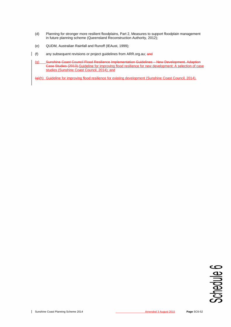
Sunshine Coast Planning Scheme 2014 Amended 3 August 2015 Page SC6-52
(d) Planning for stronger more resilient floodplains, Part 2, Measures to support floodplain management
in future planning scheme (Queensland Reconstruction Authority, 2012); (e) QUDM, Australian Rainfall and Runoff (IEAust, 1999); (f) any subsequent revisions or project guidelines from ARR.org.au; and (g) Sunshine Coast Council Flood Resilience Implementation Guidelines – New Development. Adaption
Case Studies (2013).Guideline for improving flood resilience for new development: A selection of case studies (Sunshine Coast Council, 2014); and
(g)(h) Guideline for improving flood resilience for existing development (Sunshine Coast Council, 2014).

Sunshine Coast Planning Scheme 2014 Amended 3 August 2015 Page SC6-181
Figure SC6.14.1A Potential savings and cost relationship
COST $
COST OF MAKING CHANGES POTENTIAL FOR MAKING SAVINGS
DESIGN
TIME
HAND OVER
(4) The preparation of a life cycle management plan and funding options may be requested for those
proposed contributed assets that are considered over and above the level of service represented by the standards contained in this planning scheme policy.
(5) For these assets to be acceptable to Council, the lifecycle costing of the proposed asset needs to
be evaluated to determine:-
(a) maintenance and operational requirements for the ongoing management of the asset; and
(b) the costs associated with the ongoing management of the asset. (6) The maintenance, operational and replacement costs of these assets are to be evaluated over
the operating life of the asset or for a minimum of 30 years. Applicants should provide:-
(a) a detailed assessment of the relevant infrastructure network and how it operates; (b) a detailed management system; and (c) a forecast of ongoing maintenance costs associated with the operating life of the asset.
(7) A life cycle management plan should consider all management options and strategies as part of
the asset lifecycle from planning to disposal. The objective of this is to consider lowest life cycle cost (rather than short term savings) when making asset management decisions.
(8) Strategies are to be defined for each stage. Recurrent costs, being operations and maintenance,
and capital costs, such as renewal/rehabilitation/replacement, upgrade/augmentation, enhancement (new assets) and disposal are referred to in Table SC6.14.1A (Life cycle expenditure categories).
Table SC6.14.1A Life cycle expenditure categories
Category Definition Typical examples Maintenance Expenditure related to the ongoing
up keep of assets Mowing, painting, inspections
Operations Expenditure on day to day activity of business operations
Power costs, utility costs
Renewals / Rehabilitation / Replacement
Expenditure in maintaining the current level of service by reinstating the original life of the asset
Reseal, replacement
Upgrade / augmentation Expenditure on upgrading the level of service by investment in an existing infrastructure or service
Widening or sealing of roads, traffic calming
Expansion Expenditure on increasing the level of service by investment in new assets
New assets or services as part of a new subdivision
Disposal Any costs associated with the disposal or decommissioning of assets
Sale of material or plant, road closure, removal of assets

Sunshine Coast Planning Scheme 2014 Amended 3 August 2015 Page SC6-198
Stormwater reserves and stormwater easements (6) Stormwater reserve or where appropriate park or road reserve will generally be required over all
stormwater flow paths and their verges unless specially approved in the following circumstances:-
(a) development of rural size lots;
(b) development of rural residential size lots where:-
(i) the catchment is smaller than 5 hectares; (ii) the flow path does not adjoin a park area; and (iii) blockage of the flow path will not cause flooding of adjoining lots; and
(c) development of urban land where:-
(i) Council-controlled land does not drain into the flow path; (ii) the catchment is smaller than one hectare; and (iii) blockage of the flow path will not cause flooding of adjoining lots.
(7) Stormwater reserve or where appropriate park or road reserve will be required over all areas
containing detention basins, gross pollutant traps and other stormwater quality improvement devices, and verges required to adequately serve or maintain these devices. The reserve will not be less than 5.0m wide.
(8) Easements are required over all stormwater networks (natural and constructed), which traverse
private property. Additional information is provided in QUDM. All costs associated with the provision of an easement are to be borne by the applicant.
(9) The building of structures over or upon easements is not generally in the interest of the party that
is vested in the easement. Accordingly, development applications that involve a proposal to build over or upon easements are required to demonstrate that:-
(a) the proposal does not conflict with the terms of the easement agreement; (b) the proposed structure or the construction of the proposed structure does not increase
loadings on the underground infrastructure assets; (c) the stormwater network through the easement does not include an overland flowpath or
an open channel;
(d) the proposed structure does not restrict (or prevent) access of maintenance staff and plant; and
(e) fencing allows free passage of flow.
(10) Vestment:-
(a) all reserves and easements to be vested to Council shall only occur after written consent is obtained from the relevant stormwater asset custodian and land custodians within Council;
(b) easements are to be vested in favour of Council for all stormwater networks structures
and/or facilities which are or will be the responsibility of Council to preserve and maintain; and
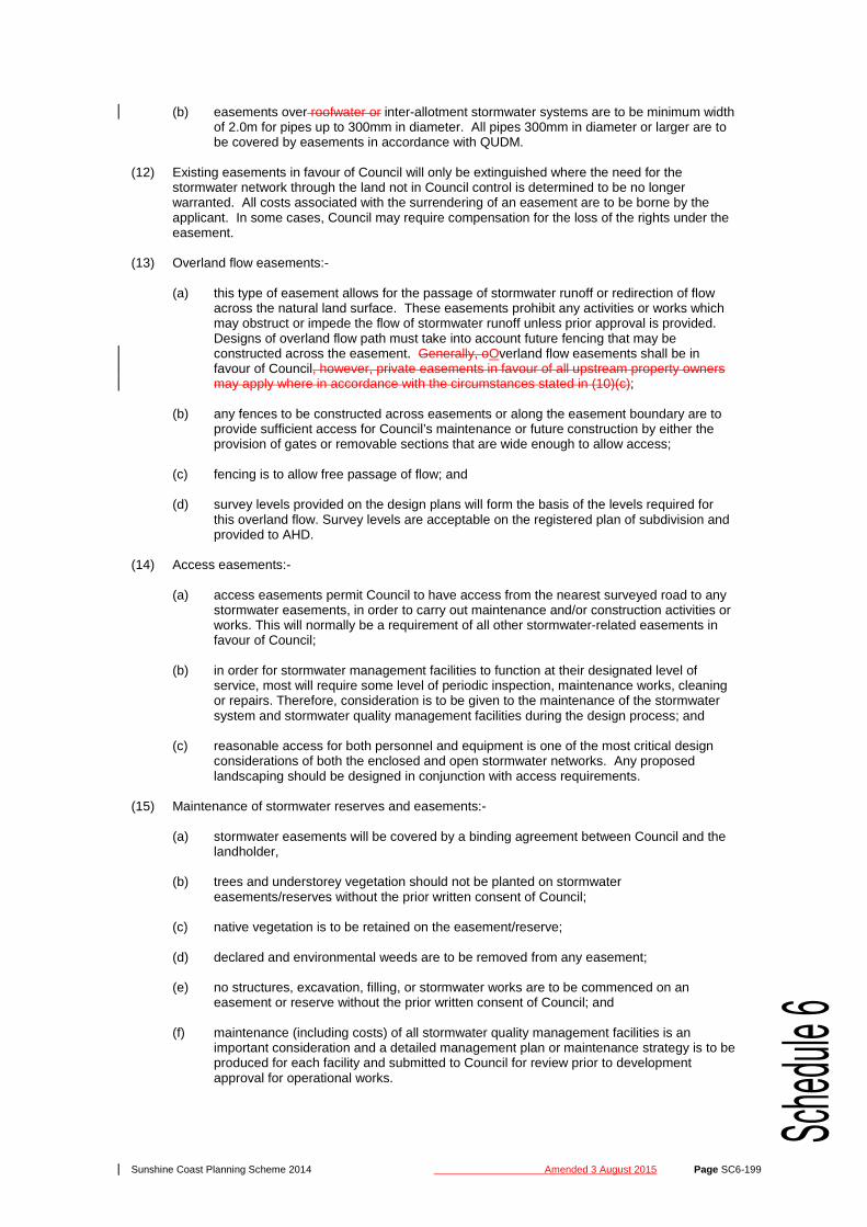
(c) roofwater/inter-allotment stormwater systems and associated cut off/swale drains are
considered as private drains and future maintenance responsibility will vest with the property owners. An easement in favour of all upstream property owners Council will be required over these stormwater systems.
(11) Easement dimensions:-
(a) easements to be registered in favour of Council are to comply with QUDM and have a minimum width of 4.0m except where the easement is for inter-allotment stormwater systems; and
Sunshine Coast Planning Scheme 2014 Amended 3 August 2015 Page SC6-199
(b) easements over roofwater or inter-allotment stormwater systems are to be minimum width of 2.0m for pipes up to 300mm in diameter. All pipes 300mm in diameter or larger are to be covered by easements in accordance with QUDM.
(12) Existing easements in favour of Council will only be extinguished where the need for the
stormwater network through the land not in Council control is determined to be no longer warranted. All costs associated with the surrendering of an easement are to be borne by the applicant. In some cases, Council may require compensation for the loss of the rights under the easement.
(13) Overland flow easements:-
(a) this type of easement allows for the passage of stormwater runoff or redirection of flow across the natural land surface. These easements prohibit any activities or works which may obstruct or impede the flow of stormwater runoff unless prior approval is provided. Designs of overland flow path must take into account future fencing that may be constructed across the easement. Generally, oOverland flow easements shall be in favour of Council, however, private easements in favour of all upstream property owners may apply where in accordance with the circumstances stated in (10)(c);
(b) any fences to be constructed across easements or along the easement boundary are to
provide sufficient access for Council’s maintenance or future construction by either the provision of gates or removable sections that are wide enough to allow access;
(c) fencing is to allow free passage of flow; and
(d) survey levels provided on the design plans will form the basis of the levels required for
this overland flow. Survey levels are acceptable on the registered plan of subdivision and provided to AHD.
(14) Access easements:-
(a) access easements permit Council to have access from the nearest surveyed road to any stormwater easements, in order to carry out maintenance and/or construction activities or works. This will normally be a requirement of all other stormwater-related easements in favour of Council;
(b) in order for stormwater management facilities to function at their designated level of
service, most will require some level of periodic inspection, maintenance works, cleaning or repairs. Therefore, consideration is to be given to the maintenance of the stormwater system and stormwater quality management facilities during the design process; and
(c) reasonable access for both personnel and equipment is one of the most critical design
considerations of both the enclosed and open stormwater networks. Any proposed landscaping should be designed in conjunction with access requirements.
(15) Maintenance of stormwater reserves and easements:-
(a) stormwater easements will be covered by a binding agreement between Council and the landholder,
(b) trees and understorey vegetation should not be planted on stormwater
easements/reserves without the prior written consent of Council; (c) native vegetation is to be retained on the easement/reserve; (d) declared and environmental weeds are to be removed from any easement; (e) no structures, excavation, filling, or stormwater works are to be commenced on an
easement or reserve without the prior written consent of Council; and (f) maintenance (including costs) of all stormwater quality management facilities is an
important consideration and a detailed management plan or maintenance strategy is to be produced for each facility and submitted to Council for review prior to development approval for operational works.

Sunshine Coast Planning Scheme 2014 Amended 3 August 2015 Page SC6-200
SC6.14.3.4 Development design
General (1) The design of urban stormwater systems is to be in accordance with the following guidelines with
this order defining the precedence of any one document over another:-
(a) QUDM;
(b) Water Sensitive Urban Design Guidelines for South East Queensland; and
(c) Australian Rainfall and Runoff (ARR). (2) The design of rural stormwater systems is to be in accordance with the following guidelines with
this order defining the precedence of any one document over another:-
(a) DTMR – Road Drainage Manual; and
(b) Australian Rainfall and Runoff (ARR). (3) The interpretation of urban and rural environments is to be made by reference to the zone within
which the land is included in the planning scheme. (4) Drainage structures are to be in accordance with the IPWEAQ Standard Drawings. (5) Inter-allotment stormwater systems or roofwater stormwater systems that take more than one
allotment do not discharge to kerb and channel. The inter-allotment stormwater systems or roofwater stormwater systems are to be connected to a Council gully pit, field inlet or manhole to the satisfaction of Council. Inspection pits or field inlets (constructed at the low point of each allotment) are to be provided at regular intervals along the roofwater stormwater system and must be in accordance with IPWEAQ Standard Drawing D-0110.
(6) A connection point at the lowest point is to be provided for each property. This connection point
is to be a minimum of 100mm in diameter for Urban Residential-Low Density, 150mm for Urban Residential High Density and 225mm for commercial or industrial development as defined in QUDM.
(7) All rear of allotment (roofwater) stormwater systems are to discharge to a Council gully, field inlet
or the like and not to the kerb and channel. Inspection pits or field inlets (constructed at the low point of each allotment) are to be provided at regular intervals along the roofwater stormwater system and must be in accordance with IMEAQ Standard Drawing D-0110.
(8)(7) Where there is a requirement for the stormwater management system to connect to an existing
Council asset, the connection is to:-
(a) not cause structural damage to or failure of the existing asset;
(b) be appropriately sealed; and
(c) not interfere with or reduce the intended purpose of the existing asset. (9)(8) For connecting pipes into enclosed stormwater networks connections are to be made only to
gully pits, manholes and field inlets. The connection is to be core-drilled and sealed with a two-part epoxy sealant.
Residential zone category (10)(9) Land in the Low density residential zone as defined in the planning scheme is to be considered
as Urban Residential-Low Density where greater than 5 dwellings per hectare but less than 20 dwellings per hectare in accordance with QUDM and as such, the appropriate minor storm design event and runoff co-efficient as per QUDM will apply.
(11)(10) Land in the Medium density residential zone, High density residential zone or Tourist
accommodation zone as defined in the planning scheme where greater than 20 dwellings per hectare or for multiple dwellings is to be considered as Urban Residential-High Density in accordance with QUDM.
(12)(11) Allotments which do not fall at least 1 in 200 towards the road reserve must be provided with a
rear of allotment roofwater stormwater system in accordance with QUDM. A minimum Level 32 is

Sunshine Coast Planning Scheme 2014 Amended 3 August 2015 Page SC6-201
required for all Urban Residential – Low Density lots, while Level 3 will be required for all other activities of residential development (except rural and rural residential). This roofwater system will be required regardless of the downhill property type. Hydraulic engineers shall determine the size of Level 1 soakage pits (if allowed), and Level 3 bund or raised mowing strip.
(13)(12) For allotments which do fall towards the road reserve (refer Figure SC6.14.3A (Residential
outfalls towards the road)), two kerb adaptors are to be provided and are to conform to IPWEAQ Standard Drawing R-0081. One should be located at the centre of the block and the other 500mm from the common boundary on the low side. Where a concrete footpath is to be constructed a 90mm diameter UPVC pipe is to extend from the adaptor to the property boundary in accordance with Council’s Standard Drawings.
Figure SC6.14.3A Residential outfalls towards the road
(14)(13) At least one connection point generally at the lowest point is to be provided for each property.
This connection point is to be a minimum of 100mm in diameter for Urban Residential – Low Density and 150mm for Urban Residential – High Density (QUDM).
Rural and Rural residential zone category (15)(14) Development in the Rural zone and the Rural residential zone as defined in the planning
scheme is to be considered as Rural Residential in accordance with QUDM. (16)(15) For land in the Rural zone or Rural residential zone, stormwater runoff from the road reserve
may be discharged directly onto the subject subdivision should it be impossible to direct stormwater to a watercourse.
(17)(16) A stormwater reserve or easement will be required over the stormwater outlet from the road
reserve (refer to Section SC6.14.3.5 (Design requirements – stormwater drainage) ). A property note informing property owners that stormwater discharges will occur during rainfall and that the amenity of their allotment may be reduced may be applied.
(17) Allotments which are less than 2000m² in area and have on-site effluent disposal require inter-
allotment stormwater. This should be designed as per Urban Residential – Low Density (QUDM).
(18) Access to rural residential and rural building sites is to flood free during a 39% AEP event and ensure that a low hazard criteria is met. The safety of the site can be determined by the following equation: Low Hazard: D + 0.3V ≤ 0.8 where D = depth of floodwater in the DFE (m) and must be less than 0.8m and V = velocity of floodwaters in the DFE (m/s) and must be less than 2m/s.
Centre zone category and Industry zone category (19) Development in the Centre zone category as defined in the planning scheme is to be considered
as:-
(a) Commercial and Industrial in accordance with QUDM; and
(b) Central Business and Commercial in accordance with QUDM.

Sunshine Coast Planning Scheme 2014 Amended 3 August 2015 Page SC6-202
(20) Development in the Industry zone category as defined in the planning scheme is to be considered as:-
(a) Commercial and Industrial in accordance with QUDM; and (b) Industrial in accordance with QUDM.
(21) Should the land fall away from the road reserve, roofwater stormwater system must be provided
in accordance with QUDM (Levels, 3, 4 and 5). (22) For land which falls towards the road reserve, the roofwater system is to be piped and connected
to the trunk drainage system at a manhole or gully. A stub is to be provided in new stormwater networks for this purpose, located 600mm within the front property boundary (refer Figure SC6.14.3B (Inter-allotment stormwater locations) ). This must also be within 1.2m from the common boundary on the low side (refer Council’s Standard Drawings). Where a site is being redeveloped, the lot must be reconfigured to ensure that these requirements are met.
(23) At least one connection point, generally at the lowest point, is to be provided for each property.
This connection point is to be minimum of 225mm for commercial or industrial development (QUDM).
Figure SC6.14.3B Inter-allotment stormwater locations
Recreation zone category (24) Development in the Recreation zone category as defined in the planning scheme is to be
considered as Open Space and Parks in accordance with QUDM.
(25) The natural stormwater corridor should be retained in land designated for public open space, i.e. park, stormwater, or road reserve.
(26) Pipe stormwater networks are generally required through parks designated for active use. Care
should be taken over the design of surcharge pits and inlet structures, so as to ensure that safety and amenity criteria are satisfied.
(27) The planning for dual use (e.g. stormwater networks and park) is to integrated within the whole
planning process to ensure that the final design provides for amenity, health and safety and stormwater management functions of the development.
(28) For public safety purposes, all public facilities such as play equipment and BBQs are to be
located clear of 1% AEP flood levels and clear of 1% AEP overland flow paths. (29) Stormwater standards to be applied to a dual use area must be considered in terms of the mix of
functional uses such as:-
NOTES: 1. Minimum cover to roofwater pipes
be 450mm500mm. 2. Roofwater drainage systems shall
discharge into gully or stormwater manhole.

Sunshine Coast Planning Scheme 2014 Amended 3 August 2015 Page SC6-208
(e) hydraulic analysis and structural testing data are to accompany the design if it is proposed to use alternative components;
(f) the gully manholes are not to pose a public safety risk; and (g) the gully manhole complies with the requirements as detailed in this section.
Pipes (44) Pipes within the stormwater conveyance system shall have a minimum diameter of 375mm
including anti-ponding gullies. (45) Pipes of 300mm are acceptable for driveway or road culverts providing that if the capacity is
exceeded there is no risk to other assets or worsening. (46) While Council will approve the use of any structurally sound pipe, prior approval must be sought
for the use of any pipe other than steel reinforced (RCP) concrete pipes. Saltwater cover RCP pipes are to be used in locations where the stormwater network may be subject to tidal wetting and drying.
(47) Rubber ring joint pipes are to be used for pipes up to and including 600mm diameter and
external bands (EB Joint) for larger than 600mm diameter.all pipes. Prior approval must be sought for the use of external band joint pipes. Butt joint pipes are not permitted.
(48) Service and construction loadings are to be calculated in accordance with AS 3725: Loads on
Buried Concrete Pipes. In many cases, construction loading will be the critical load case for selection of pipe class. AS 4058: Precast Concrete Pipes (Pressure and Non-Pressure) will apply for testing requirements or where standard steel reinforced concrete pipes may be exposed to aggressive conditions.
(49) To counteract premature pipe cracking, the following are required:-
(a) the design and selection of the pipe type and class is to consider construction loading (based upon the calculations described above), which is usually the critical load case for pipes < 900mm diameter;
(b) stormwater plans issued for construction are required to indicate for each drain line the
following:- (i) pipe type and class; (ii) installation type; and (iii) construction method (layer thickness, compaction plant);
(c) design aids available from concrete pipe manufacturers may be used and are
recommended. These include software for calculation of loads on pipes to AS 3725, tables and charts. It is recommended that charts showing the relationship between compaction equipment and pipe class are also included with the engineering drawings;
(d) no more than two weeks before the on-maintenance inspection and prior to the formal
acceptance of on-maintenance, closed circuit television camera (CCTV) inspection is required to demonstrate that the standard of the stormwater network is acceptable to Council. CCTV inspections can be arranged through suitably qualified service providers. Any defects identified by the inspection are to be repaired or replaced or as directed by Council. A follow up camera survey is required to demonstrate that the remediation measures are satisfactory. The CCTV pipe surveys are required to conform to Council’s standard inspection and reporting protocols; and
(e) cracked pipes shall be rejected. Hairline or crazing cracks associated with concrete
shrinkage are permitted. Box culverts (50) Box culverts may be used where low vertical clearances exist or as approved; however, circular
sections should be used in enclosed stormwater networks wherever possible. (51) Box sections are to be constructed from precast reinforced concrete box culvert sections. (52) The minimum dimension of a box culvert is to be 375mm.
Sunshine Coast Planning Scheme 2014 Amended 3 August 2015 Page SC6-213
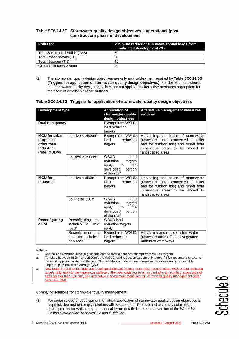
Table SC6.14.3F Stormwater quality design objectives – operational (post construction) phase of development
Pollutant Minimum reductions in mean annual loads from unmitigated development (%)
Total Suspended Solids (TSS) 80 Total Phosphorous (TP) 60 Total Nitrogen (TN) 45 Gross Pollutants > 5mm 90
(2) The stormwater quality design objectives are only applicable when required by Table SC6.14.3G
(Triggers for application of stormwater quality design objectives). For development where the stormwater quality design objectives are not applicable alternative measures appropriate for the scale of development are outlined.
Table SC6.14.3G Triggers for application of stormwater quality design objectives
Development type Application of stormwater quality design objectives
Alternative management measures required
Dual occupancy Exempt from WSUD load reduction targets
MCU for urban purposes other than industrial (refer QUDM)
Lot size < 2500m2 Exempt from WSUD load reduction targets
Harvesting and reuse of stormwater (rainwater tanks connected to toilet and for outdoor use) and runoff from impervious areas to be sloped to landscaped areas
Lot size ≥ 2500m2 WSUD load reduction targets apply to the developed portion of the site1
MCU for industrial
Lot size < 850m2 Exempt from WSUD load reduction targets
Harvesting and reuse of stormwater (rainwater tanks connected to toilet and for outdoor use) and runoff from impervious areas to be sloped to landscaped areas
Lot ≥ size 850m WSUD load reduction targets apply to the developed portion of the site2
Reconfiguring a Lot
Reconfiguring that includes a new road3
WSUD load reduction targets apply
Reconfiguring that does not include a new road
Exempt from WSUD load reduction targets
Harvesting and reuse of stormwater (rainwater tanks). Protect vegetated buffers to waterways
Notes – 1. Sparse or distributed sites (e.g. cabins spread over a site) are exempt from WSUD targets. 2. For sites between 850m2 and 2500m2, the WSUD load reduction targets only apply if it is reasonable to extend
the existing piping system to the site. The calculation to determine a reasonable extension is: reasonable length of pipe (m) = site area (m2))/50.
3. New roads in rural residential/rural reconfigurations are exempt from these requirements. WSUD load reduction targets only apply to the impervious surface of the new roads.For rural residential/rural reconfigurations with lot sizes greater than 3,000m2, see alternative management measures for stormwater quality management (refer SC6.14.3.7(8)).
Complying solutions for stormwater quality management (3) For certain types of development for which application of stormwater quality design objectives is
required, deemed to comply solutions will be accepted. The deemed to comply solutions and developments for which they are applicable are detailed in the latest version of the Water by Design Bioretention Technical Design Guideline.
Sunshine Coast Planning Scheme 2014 Amended 3 August 2015 Page SC6-223
(13) QUDM presents the concept of major system and minor system design. It presents appropriate AEPs and notes that a local authority may vary the design AEPs to suit local conditions.
(14) The boundaries of catchments and sub-catchments are to be determined in accordance with
QUDM. Council has additional information within its GIS system to assist in the determination of catchment and sub-catchment areas. Boundaries should be verified by site inspection and certified as correct.
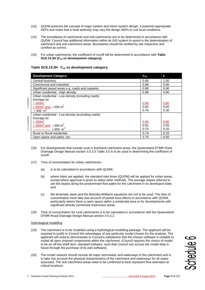
(15) For urban catchments, the coefficient of runoff will be determined in accordance with Table
SC6.14.3H (C10 vs development category).
Table SC6.14.3H C10 vs development category
Development Category C10 fi Central business 0.90 1.00 Commercial and industrial 0.88 0.90 Significant paved areas e.g. roads and carparks 0.88 0.90 Urban residential - High density 0.88 0.90 Urban residential - Low density (including roads) Average lot < 450m2
≥ 450m2 and < 650 m2
≥ 650 m2
0.86 0.82 0.76
0.80 0.60 0.30
Urban residential - Low density (excluding roads) Average lot < 450m2
≥ 450m2 and < 650 m2 ≥ 650 m2
0.86 0.81 0.75
0.80 0.55 0.25
Rural or Rural residential 0.74 0.20 Open space and parks, etc. 0.70 0.00
(16) For developments that include rural or bushland catchment areas, the Queensland DTMR Road
Drainage Design Manual section 3.5.3.3 Table 3.5 is to be used in determining the coefficient of runoff.
(17) Time of concentration for urban catchments:-
(a) is to be calculated in accordance with QUDM;
(b) where inlets are applied, the standard inlet times (QUDM) will be applied for urban areas,
except where approval is given to utilise other methods. The average slopes referred to are the slopes along the predominant flow paths for the catchment in its developed state; and
(c) the kinematic wave and the Bransby-Williams equations are not to be used. The time of
concentration must take due account of partial area effects in accordance with QUDM, particularly where there is open space within a residential area or for developments with significant directly connected impervious areas.
(18) Time of concentration for rural catchments is to be calculated in accordance with the Queensland
DTMR Road Drainage Design Manual section 3.5.3.2. Hydrological modelling (19) The catchment is to be modelled using a hydrological modelling package. The applicant will be
required to justify to Council the advantages of any particular model chosen for the analysis. The applicant will need to demonstrate to Council’s satisfaction that the chosen software is suitable to model all open channel components within the catchment. (Council requires the choice of model to be an off-the-shelf item, standard software, such that Council can access the model data in future through the purchase of its own software).
(20) The model network should include all major stormwater and waterways in the catchment and is
to take into account the physical characteristics of the catchment and waterways for all cases assessed. The sub-catchment areas need to be confirmed to best represent flow estimates at critical locations.

Sunshine Coast Planning Scheme 2014 Amended 3 August 2015 Page SC6-227
WSAA Drawing Numbers
Status Remarks
WAT-1212 Adopted WAT-1213 Adopted WAT-1214 Adopted WAT-1300 Not adopted Use SCW 365 WAT-1301 Not adopted Use SCW 320 WAT-1302 Not adopted Use SCW 320 & SCW 325 WAT-1303 Not adopted Use SCW 320 & SCW 325 WAT-1304 Not adopted Use SCW 320 & SCW 325 WAT-1305 Not adopted Use SCW 320 & SCW 325 WAT-1306 Not adopted Use SCW 320 & SCW 325 WAT-1307 Adopted WAT-1308 Not adopted WAT-1309 Not adopted Use SCW 330 WAT-1310 Adopted WAT-1311 Adopted WAT-1312 Adopted WAT-1313 Adopted WAT-1400 Adopted WAT-1401 Adopted WAT-1402 Adopted WAT-1403 Adopted WAT-1404 Adopted WAT-1405 Adopted WAT-1406 Adopted WAT-1407 Adopted WAT-1408 Adopted WAT-1409 Not adopted (2) The alignments and details for water and sewerage mains and service conduits should be in
accordance with Table SC6.14.4B (Service corridors and alignments) .
Table SC6.14.4B Service corridors and alignments
Public Utilities – Typical Service Corridors and Alignments
Remarks
SEQ R-100 Public utilities in Verges, Service Corridors & Alignments SEQ R-101 Public Utilities – Typical Service Conduit Sections
SC6.14.4.4 Planning and design
(1) The standards in this section have been developed to define the particular requirements of Unitywater in relation to the WSAA National Codes. Only details that differ from that of the WSAA National Codes are provided.
(2) These standards shall be read in conjunction with, and take precedence over, the WSAA Water
Supply Code of Australia – WSA 03-2002 to define the technical requirements of Unitywater in relation to the planning, design and construction of water supply systems (refer Table SC6.14.4C (Variations to the WSAA national codes) ).
Table SC6.14.4C Variations to the WSAA national codes
Part Variations Pt 1 –1.5.2 Water Agency
Add to WSAA requirement:- • For development proposals, Unitywater may request that a water supply
network analysis be undertaken to determine (a), (b) and (c). Pt 1 – 2.1 System Planning Process
Add to WSAA requirement:- • The designer shall liaise with Unitywater prior to commencement of the
design. Pt 1 – 2.2 Demands
Replace WSAA requirement with:- • Water demands shall be determined in accordance with Unitywater’s “Level
of Service Impact Assessment Specification”. Pt 1 – 2.2.3 Peak Replace WSAA requirement with:-

Sunshine Coast Planning Scheme 2014 Amended 3 August 2015 Page SC6-359
Criteria Arterial Roads Sub-arterial Roads District Streets Neighbourhood Streets
Local Streets
Hig
hway
/ M
otor
way
Art
eria
l Roa
d
Art
eria
l Mai
n St
reet
Dis
trib
utor
Con
trol
led
Dis
trib
utor
Sub-
Art
eria
l M
ain
Stre
et
Dis
tric
t C
olle
ctor
Str
eet
Dis
tric
t Mai
n St
reet
Nei
ghbo
urho
od
Col
lect
or S
tree
t
Mix
ed U
se
Col
lect
or S
tree
t
Acc
ess
Stre
et
Mix
ed U
se
Acc
ess
Stre
et
Acc
ess
Plac
e
Acc
ess
Lane
way
Median desirable desirable desirable localised where required, if not entire street
May intersect with usually a corridor one classification higher or lower. Other intersections only where there is no alternative, subject to other design requirements.
access laneway access street neighbourhood collector mixed use collector district collector sub-arterials arterials highways
Minimum intersection spacing (metres) + 150 if constrained by existing development * same side, # opposite side
1.5-2km 0.5-1km >150 300 300+ 150 100* 80# 100 if median
100 60* 40#
60 60* 40#
40 40 40
Stopping distance (metres) Austroads guidelines 42 30 20 20 20 10 General minimum sight distance (metres) Austroads guidelines 84 60 40 40 40 20 Street leg length (metres)
Desirable 150 150 100 150 100 100 100 75 75 75 Maximum 180 180 155 180 120 ≤140 120 75 75 75
End conditions (km/h) ≤25 ≤25 Desirable maximum grade (%) specific
consideration
5 5 8 8 8 8 8 12 6 12 6 12 12 Absolute maximum grade (%) + up to 20% for ≤100m over the entire street, if constrained and limited heavy vehicle use
6 7 10 10 10 12 (10 if >5,000vpd)
12 (10 if >5,000vpd)
15 (12 if rear lane access)
12 15+ 12 15+ 15+
Freight route primary (except through populated areas)
yes yes yes selected routes restricted access no restricted access
no
Dangerous goods route restricted access restricted access restricted access no restricted access
no
Longitudinal drainage
kerb & channel swale
Street lighting Refer AS1158.3.1: 2005 Note Optional at discretion of Council. Note—DTMR current guidelines or standards apply to planning and design of State-controlled roads. Note—DTMR approval is required where any additional access is sought or existing access is modified to a State-controlled road.

Sunshine Coast Planning Scheme 2014 Amended 3 August 2015 Page SC6-385
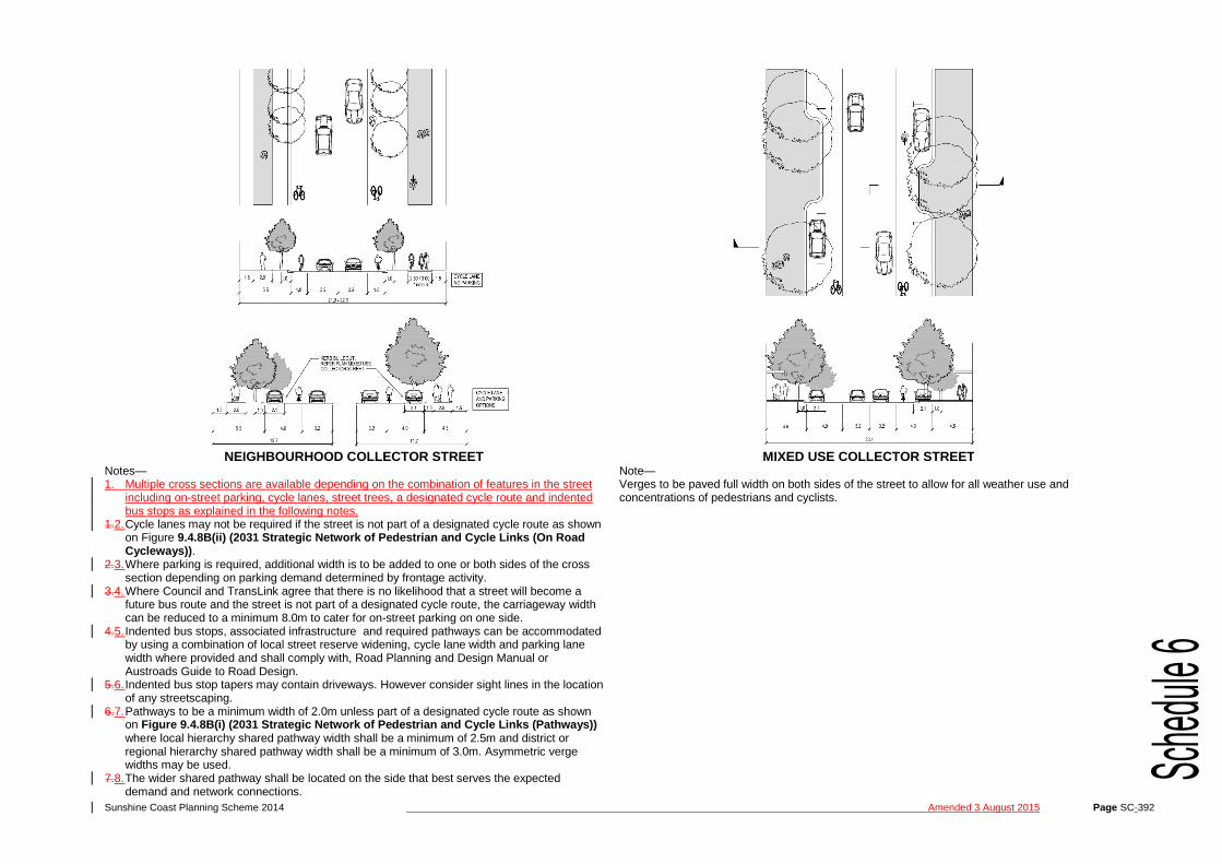
Appendix S CS6.17A Typical street and road cross sections
RURAL RESIDENTIAL ACCESS PLACE RURAL RESIDENTIAL ACCESS STREET
Sunshine Coast Planning Scheme 2014 Amended 3 August 2015 Page SC-392
NEIGHBOURHOOD COLLECTOR STREET MIXED USE COLLECTOR STREET
Notes— 1. Multiple cross sections are available depending on the combination of features in the street
including on-street parking, cycle lanes, street trees, a designated cycle route and indented bus stops as explained in the following notes.
1.2. Cycle lanes may not be required if the street is not part of a designated cycle route as shown on Figure 9.4.8B(ii) (2031 Strategic Network of Pedestrian and Cycle Links (On Road Cycleways)) .
2.3. Where parking is required, additional width is to be added to one or both sides of the cross section depending on parking demand determined by frontage activity.
3.4. Where Council and TransLink agree that there is no likelihood that a street will become a future bus route and the street is not part of a designated cycle route, the carriageway width can be reduced to a minimum 8.0m to cater for on-street parking on one side.
4.5. Indented bus stops, associated infrastructure and required pathways can be accommodated by using a combination of local street reserve widening, cycle lane width and parking lane width where provided and shall comply with, Road Planning and Design Manual or Austroads Guide to Road Design.
5.6. Indented bus stop tapers may contain driveways. However consider sight lines in the location of any streetscaping.
6.7. Pathways to be a minimum width of 2.0m unless part of a designated cycle route as shown on Figure 9.4.8B(i) (2031 Strategic Network of Pedestrian and Cycle Links (Pathways)) where local hierarchy shared pathway width shall be a minimum of 2.5m and district or regional hierarchy shared pathway width shall be a minimum of 3.0m. Asymmetric verge widths may be used.
7.8. The wider shared pathway shall be located on the side that best serves the expected demand and network connections.
Note— Verges to be paved full width on both sides of the street to allow for all weather use and concentrations of pedestrians and cyclists.
Sunshine Coast Planning Scheme 2014 Amended 9 March 2015Amended 3 August 2015
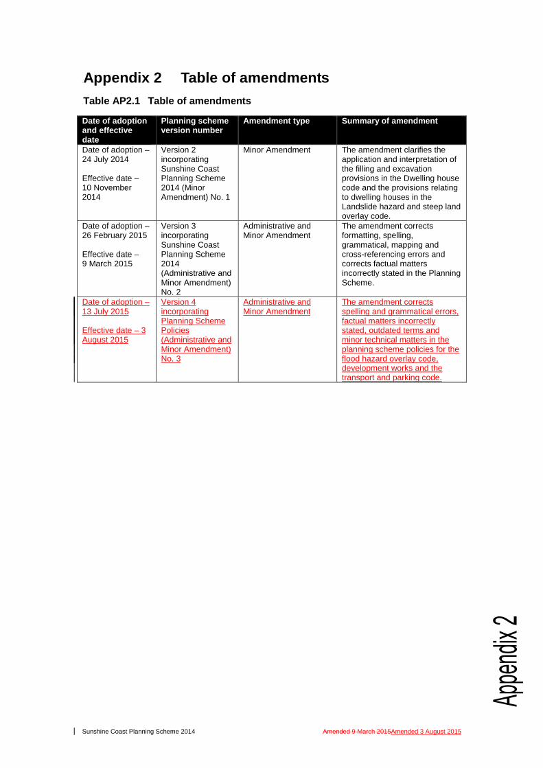
0BAppendix 2 Table of amendments 1BTable AP2.1 Table of amendments
Date of adoption and effective date
Planning scheme version number
Amendment type Summary of amendment
Date of adoption – 24 July 2014 Effective date – 10 November 2014
Version 2 incorporating Sunshine Coast Planning Scheme 2014 (Minor Amendment) No. 1
Minor Amendment The amendment clarifies the application and interpretation of the filling and excavation provisions in the Dwelling house code and the provisions relating to dwelling houses in the Landslide hazard and steep land overlay code.
Date of adoption – 26 February 2015 Effective date – 9 March 2015
Version 3 incorporating Sunshine Coast Planning Scheme 2014 (Administrative and Minor Amendment) No. 2
Administrative and Minor Amendment
The amendment corrects formatting, spelling, grammatical, mapping and cross-referencing errors and corrects factual matters incorrectly stated in the Planning Scheme.
Date of adoption – 13 July 2015 Effective date – 3 August 2015
Version 4 incorporating Planning Scheme Policies (Administrative and Minor Amendment) No. 3
Administrative and Minor Amendment
The amendment corrects spelling and grammatical errors, factual matters incorrectly stated, outdated terms and minor technical matters in the planning scheme policies for the flood hazard overlay code, development works and the transport and parking code.