al-5476 (faa) rwy idg rnav (gps) rwy 24 tdze apt elev (ikw
TRANSCRIPT

0.4% UP
P
P
P
P
6
36
18
3801 X 75
30
01
X 7
5
24
RW24
066°
246°4 NM
246°06
6°
246°
MSA RW24 25 NM
2900
156°
(5)
3000 N
oPT
336°
(5)
3000 N
oPT
2300
(6.1)
173°
3000
(17.3)
032°
3000
(10.2)
804
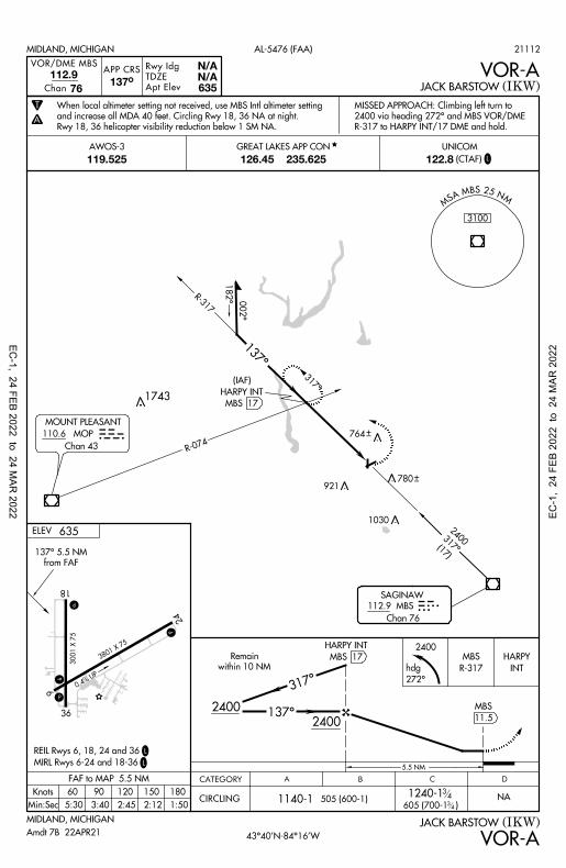
MIDLAND, MICHIGAN
(IKW)JACK BARSTOW
AL-5476 (FAA)
A
APP CRS
Apt Elev
TDZE
Rwy Idg
246°635635
3801 RNAV (GPS) RWY 24WAAS
CH
W24A
72912
T
ELEV
*
MIDLAND, MICHIGAN
635
L
L
RW24
246° to
MIRL Rwys 6-24 and 18-36
REIL Rwys 6, 18, 24 and 36
(IKW)JACK BARSTOW
CATEGORY A B C D
NA
3000
2300
066°
246°246
°
RW24
RNAV (GPS) RWY 24
NA
6.1 NM
386 (400-1 )14
14
DA 1068-1 433 (500-1 )12
12
1060-1
425 (500-1 )
CIRCLING
NA
NA
14
14
1060-1425 (500-1)
1120-1485 (500-1)
3.2 NM1.8
1260*
LNAV only.
VNAV
LNAV/
LNAV MDA
1021-1
RW24
1.8 NM to
EHAFY
EGOPE
(IAF)
MBS
SAGINAW
CADOB
DOLTE
(IAF)
FAMED
(IF/IAF)
BIRSE
(FAF)
BANJO
4 NM
Holding Pattern
4 NM3000 CADOB
RW24
1.8 NM to
EHAFY
BIRSE
FAMED
MOP
MOUNT PLEASANT
(30.8)
072°30
00
DALPV
VOR/DME via V45 southbound.
Procedure NA for arrivals at MBS
1743
635TDZE
43°40'N-84°16'W
UNICOM
119.525 122.8(CTAF)126.45 235.625 L
(VGSI Angle 3.00/TCH 24).
VGSI and RNAV glidepath not coincident
21112
Amdt 1B 22APR21
TCH 53
GP 3.00°
CADOB and hold.
Climb to 3000 direct
MISSED APPROACH:
AWOS-3
34
14 mile. Circling Rwy 18, 36 NA at night.
use MBS Intl altimeter setting and increase all DA 31 feet and all MDA 40 feet and all LPV visibility
Rwy 24 helicopter visibility reduction below SM NA. When local altimeter setting not received,
systems, LNAV/VNAV NA below -16°C (4°F) or above 54°C (130°F). DME/DME RNP-0.3 NA.
Baro-VNAV NA when using MBS Intl altimeter setting. For uncompensated Baro-VNAV
764
GREAT LAKES APP CON
921
764
1240-1
605 (700-1 )
34
34
1030
780
EC-1, 24 FEB 2022 to 24 M
AR 2022 EC
-1,
24 F
EB 2
022
to 2
4 M
AR 2
022

0.4% UP
P
P
P
P
6
36
18
3801 X 75
30
01
X 7
5
24
4 NM
246°
066°
RW06
066°
246°
MSA RW06 25 NM
2900
4 NM156°
(5)
336°
(5)
018°
3000
(10.5)
089°3000
(8.4)
268°3000
(15.6)
066°23
00
(6.1)
MIDLAND, MICHIGAN
CATEGORY A B C D
NA
NA1000-1372 (400-1)
1120-1485 (500-1)
LNAV MDA
CIRCLING
3000
1200
2300
246°
066°
TCH 32
3.04°
3000 FAMED
ELEV
(IKW)JACK BARSTOW
635
L
L
RW06
066° to
RNAV (GPS) RWY 6
APP CRS
Apt Elev
TDZE
Rwy Idg
MIDLAND, MICHIGAN
(IKW)JACK BARSTOW
AL-5476 (FAA)
066°RNAV (GPS) RWY 6
635628
3801
A
T
FAMED
MBS
SAGINAW
RW06
1.7 NM to
OBIDE
ASANE
(FAF)
3000 N
oPT
3000 N
oPT
BUDRE
(IAF)
INDEX
Holding Pattern
4 NM
via airway radials 212 CW 320.
Procedure NA for arrivals at MBS VOR/DME
MIRL Rwys 6-24 and 18-36
REIL Rwys 6, 18, 24, and 36
*
*6.1 NM 3.4 NM 1.7
066°
MOP
MOUNT PLEASANT
1743
FIBIT
(IAF)
CADOB
(IF/IAF)
CADOB
ASANE
RW06
1.7 NM to
OBIDE
RW06
UNICOM
119.525 122.8(CTAF)126.45 235.625
AWOS-3
628TDZE
43°40'N-84°16'W
L
Intl altimeter setting.
1240 when using MBS
Amdt 1B 22APR21
3000 direct FAMED and hold.
MISSED APPROACH: Climb to
21112
14
34
all MDA 40 feet and LNAV Cat C visibility mile. Circling Rwy 18, 36 NA at night.
When local altimeter setting not received, use MBS Intl altimeter setting and increase
DME/DME RNP-0.3 NA. Rwy 24 helicopter visibility reduction below SM NA.
GREAT LAKES APP CON
921
1240-1 605 (700-1 )
3434
739
1030
780
764
EC-1, 24 FEB 2022 to 24 M
AR 2022 EC
-1,
24 F
EB 2
022
to 2
4 M
AR 2
022
0.4% UP
P
P
P
P
6
36
18
3801 X 75
30
01
X 7
5
24
ELEV
CATEGORY B C DA
APP CRS
Apt Elev
TDZE
Rwy Idg
MIDLAND, MICHIGAN
MIDLAND, MICHIGAN
(IKW)
(IKW)
JACK BARSTOW
JACK BARSTOW
AL-5476 (FAA)
635
1140-1505 (600-1) NACIRCLING
VOR/DME MBS
Chan
112.9
76137°
2400
INT
HARPY
2400
2400
Remain
within 10 NM
MBS 17
HARPY INT
317°
137°
5.5 NM
002°
182°
MBS 17
HARPY INT
(IAF)
R-074
MSA MBS 25 NM
3100
Chan 43
SAGINAW
112.9 MBS
Chan 76
from FAF
137° 5.5 NM
L
2400
317°(1
7)
VOR-A
1801501209060Knots
Min:Sec
FAF to MAP 5.5 NM
5:30 3:40 2:45 2:12 1:50
VOR-A
MIRL Rwys 6-24 and 18-36
REIL Rwys 6, 18, 24 and 36L
635N/AN/A
T
A
MOUNT PLEASANT
110.6 MOP
R-317
137°
317°
272°
hdg
R-317
MBS
11.5
MBS
43°40'N-84°16'W
UNICOM
119.525 122.8(CTAF)126.45 235.625
AWOS-3
L
Amdt 7B 22APR21
1743
21112
764
Rwy 18, 36 helicopter visibility reduction below 1 SM NA.
and increase all MDA 40 feet. Circling Rwy 18, 36 NA at night.
When local altimeter setting not received, use MBS Intl altimeter setting
R-317 to HARPY INT/17 DME and hold.
2400 via heading 272° and MBS VOR/DME
MISSED APPROACH: Climbing left turn to
GREAT LAKES APP CON
921
1240-1605 (700-1 )
3434
1030
780
EC-1, 24 FEB 2022 to 24 M
AR 2022 EC
-1,
24 F
EB 2
022
to 2
4 M
AR 2
022

ALTERNATE MINS
22027
M1
EC-1
22027 M1
A A
ALTERNATE MINS A A
NAME ALTERNATE MINIMUMS NAME ALTERNATE MINIMUMS
ADRIAN, MI LENAWEE COUNTY (ADG)………..……...RNAV (GPS) Rwy 5
RNAV (GPS) Rwy 23 NA when local weather not available.
ALMA, MI GRATIOT COMMUNITY (AMN)……..…...RNAV (GPS) Rwy 9
RNAV (GPS) Rwy 27 NA when local weather not available.
ALPENA, MI ALPENA COUNTY RGNL (APN)………………...….ILS or LOC Rwy 1
1
RNAV (GPS) Rwy 12
1NA when control tower closed.
2NA when local weather not available.
ANN ARBOR, MI ANN ARBOR MUNI (ARB)………………..…..RNAV (GPS) Rwy 6
RNAV (GPS) Rwy 24 VOR Rwy 6
1
VOR Rwy 241
NA when local weather not available. 1Category D, 900-2½.
BAD AXE, MI HURON COUNTY MEMORIAL (BAX)……...……...RNAV (GPS) Rwy 4
RNAV (GPS) Rwy 17 RNAV (GPS) Rwy 22 RNAV (GPS) Rwy 35
NA when local weather not available.
BATTLE CREEK, MI BATTLE CREEK EXEC AT KELLOGG FLD (BTL)…..….....................ILS or LOC Rwy 23R
1
RNAV (GPS) Rwy 5L RNAV (GPS) Rwy 23R
NA when local weather not available. 1NA when control tower closed.
A
INSTRUMENT APPROACH PROCEDURE CHARTS
IFR ALTERNATE AIRPORT MINIMUMS
Standard alternate minimums for non-precision approaches and approaches with vertical guidance [NDB, VOR, LOC, TACAN, LDA, SDF, VOR/DME, ASR, RNAV (GPS) or RNAV (RNP)] are 800-2. Standard alternate minimums for precision approaches (ILS, PAR, or GLS) are 600-2. Airports within this geographical area that require alternate minimums other than standard or alternate minimums with restrictions are listed below. NA - means alternate minimums are not authorized due to unmonitored facility, absence of weather reporting service, or lack of adequate navigation coverage. Civil pilots see FAR 91. IFR Alternate Minimums: Ceiling and Visibility Minimums not applicable to USA/USN/USAF. Pilots must review the IFR Alternate Minimums Notes for alternate airfield suitability.
BEAVER ISLAND, MI BEAVER ISLAND (SJX)…………………RNAV (GPS) Rwy 27 NA when local weather not available.
BELLAIRE, MI ANTRIM COUNTY (ACB)………………..RNAV (GPS) Rwy 2 NA when local weather not available. Category C, 1000-2¾; Category D, 1100-3.
BENTON HARBOR, MI SOUTHWEST MICHIGAN RGNL (BEH)…………………..RNAV (GPS) Rwy 10
VOR Rwy 28 Category D, 800-2¼.
BIG RAPIDS, MI ROBEN-HOOD (RQB)…….…RNAV (GPS) Rwy 27
NA when local weather not available. Category D, 900-2¾.
CADILLAC, MI WEXFORD COUNTY (CAD)………...……...RNAV (GPS) Rwy 7
RNAV (GPS) Rwy 25 NA when local weather not available. Category D, 800-2½.
CHARLEVOIX, MI CHARLEVOIX MUNI (CVX)…………..………..RNAV (GPS) Rwy 9 NA when local weather not available.
CHEBOYGAN, MI CHEBOYGAN COUNTY (SLH)………...….....RNAV (GPS) Rwy 10
RNAV (GPS) Rwy 28 VOR Rwy 10
NA when local weather not available.
24 FEB 2022 to 24 MAR
2022 24 F
EB 2
022
to 2
4 M
AR 2
022

ALTERNATE MINS
22027
M2
EC-1
22027 M2
A A
ALTERNATE MINS A A
NAME ALTERNATE MINIMUMS NAME ALTERNATE MINIMUMS
COLDWATER, MI BRANCH COUNTY MEML (OEB)……….................RNAV (GPS) Rwy 7
RNAV (GPS) Rwy 25 VOR Rwy 7
VOR/DME Rwy 25 NA when local weather not available.
DETROIT, MI COLEMAN A YOUNG MUNI (DET)……..….................ILS or LOC Rwy 15
1
ILS or LOC Rwy 331
RNAV (GPS) Rwy 152
RNAV (GPS) Rwy 332
1LOC, Category D, 900-2¾.
2Category D, 900-2¾.
WILLOW RUN (YIP)…….…................….ILS or LOC Rwy 5R
1
ILS or LOC Rwy 23L2
RNAV (GPS) Rwy 5R4
RNAV (GPS) Rwy 934
RNAV (GPS) Rwy 23L4
VOR-A4
1ILS Category D, 700-2¼; LOC, Category D, 800-2¼.
2ILS, Category D, 700-2¼.
3NA when local weather not available.
4Category D, 800-2¼.
DETROIT/GROSSE ILE, MI GROSSE ILE MUNI (ONZ)…………….........................NDB Rwy 4
1
RNAV (GPS) Rwy 42
RNAV (GPS) Rwy 222
VOR-A2
NA when local weather not available. 1Categories A, B, 1000-2; Category C, 1000-2¾; Category D, 1000-3.
2Categories A, B, 900-2; Category C, 900-2½; Category D, 900-2¾.
ESCANABA, MI DELTA COUNTY (ESC)……....ILS or LOC Rwy 9
13
LOC/DME BC Rwy 272
RNAV (GPS) Rwy 123
RNAV (GPS) Rwy 9
2
RNAV (GPS) Rwy 1923
RNAV (GPS) Rwy 272
VOR Rwy 123
1ILS, Category C, 700-2; Category D, 900-2¾.
LOC, Category D, 900-2¾. 2Category D, 900-2¾.
3NA when local weather not available.
FLINT, MI BISHOP INTL (FNT)…….........…........…ILS or LOC Rwy 9
12
ILS or LOC Rwy 2712
RNAV (GPS) Rwy 9
3
RNAV (GPS) Rwy 1834
RNAV (GPS) Rwy 273
RNAV (GPS) Rwy 363
VOR Rwy 183
VOR Rwy 363
1NA when control tower closed.
2LOC, Category D, 800-2¼.
3Category D, 800-2¼.
4NA when local weather not available.
FRANKFORT, MI FRANKFORT DOW MEML FLD (FKS)………...……….....RNAV (GPS) Rwy 15
RNAV (GPS) Rwy 33
NA when local weather not available. Category B, 900-2; Category C, 900-2¾.
FREMONT, MI FREMONT MUNI (FFX)…….......................RNAV (GPS) Rwy 1
RNAV (GPS) Rwy 19 NA when local weather not available.
GAYLORD, MI GAYLORD RGNL (GLR)……....RNAV (GPS) Rwy 9
RNAV (GPS) Rwy 27 VOR Rwy 27
Category D, 800-2½. NA when local weather not available.
GRAND RAPIDS, MI GERALD R FORD INTL (GRR)………………..…ILS or LOC Rwy 26L
1
ILS or LOC Rwy 351
RADAR-11
RNAV (GPS) Rwy 8L2
RNAV (GPS) Rwy 172
VOR Rwy 172
1NA when control tower closed.
2NA when local weather not available.
GRAYLING, MI GRAYLING AAF (GOV)…...…RNAV (GPS) Rwy 14 NA when local weather not available. Category D, 900-2½.
24 FEB 2022 to 24 MAR
2022 24 F
EB 2
022
to 2
4 M
AR 2
022

ALTERNATE MINS
22027
M3
EC-1
22027 M3
A A
ALTERNATE MINS A A
NAME ALTERNATE MINIMUMS NAME ALTERNATE MINIMUMS
HANCOCK, MI HOUGHTON COUNTY MEML (CMX)………...........…..ILS or LOC Rwy 31
1
LOC BC Rwy 133
RNAV (GPS) Rwy 723
RNAV (GPS) Rwy 1324
RNAV (GPS) Rwy 2524
VOR Rwy 2523
1LOC, Category D, 800-2¼.
2NA when local weather not available.
3Category D, 800-2¼.
4Category D, 900-2½.
HARBOR SPRINGS, MI HARBOR SPRINGS (MGN)……...……...RNAV (GPS) Rwy 10
RNAV (GPS) Rwy 28 NA when local weather not available. Category B, 900-2.
HOLLAND, MI WEST MICHIGAN RGNL (BIV)……………...……...RNAV (GPS) Rwy 8
RNAV (GPS) Rwy 26 NA when local weather not available.
HOUGHTON LAKE, MI ROSCOMMON COUNTY - BLODGETT MEML (HTL)…………………....RNAV (GPS) Rwy 9
RNAV (GPS) Rwy 27 NA when local weather not available.
HOWELL, MI LIVINGSTON COUNTY SPENCER J HARDY (OZW)……….....…...RNAV (GPS) Rwy 13
RNAV (GPS) Rwy 31 NA when local weather not available.
IONIA, MI IONIA COUNTY (Y70)…….….RNAV (GPS) Rwy 10
RNAV (GPS) Rwy 28 NA when local weather not available.
IRON MOUNTAIN-KINGSFORD, MI FORD (IMT)…………………….RNAV (GPS) Rwy 1
RNAV (GPS) Rwy 19 VOR Rwy 31
NA when local weather not available.
IRONWOOD, MI GOGEBIC/IRON COUNTY (IWD)…………...…...RNAV (GPS) Rwy 9
RNAV (GPS) Rwy 27 VOR Rwy 9
NA when local weather not available. Categories A, B, 900-2; Categories C, D, 1000-3.
JACKSON, MI JACKSON COUNTY-REYNOLDS FLD (JXN)……………...…........ILS or LOC Rwy 25
1
RNAV (GPS) Rwy 7
NA when local weather not available. 1NA when tower closed.
KALAMAZOO, MI KALAMAZOO/BATTLE CREEK INTL (AZO)………………....…ILS or LOC Rwy 35
12
RADAR-11
RNAV (GPS) Rwy 173
VOR Rwy 353
1NA when control tower closed.
2ILS, Category C, D, 700-2.
3NA when local weather not available.
LANSING, MI CAPITAL REGION INTL (LAN)…………………...ILS or LOC Rwy 10R
1
ILS or LOC Rwy 28L2
RNAV (GPS) Rwy 63
RNAV (GPS) Rwy 10R3
RNAV (GPS) Rwy 243
RNAV (GPS) Rwy 28L3
1ILS, Category C, 800-2; Category D, 900-3;
LOC, Category D, 900-3. 2LOC, Category D, 900-3.
3Category D, 900-3.
LAPEER, MI DUPONT-LAPEER (D95)…....RNAV (GPS) Rwy 18
RNAV (GPS) Rwy 36 NA when local weather not available.
LUDINGTON, MI MASON COUNTY (LDM)……..RNAV (GPS) Rwy 8
RNAV (GPS) Rwy 26
NA when local weather not available.
MACKINAC ISLAND, MI MACKINAC ISLAND (MCD)……………...….RNAV (GPS) Rwy 8
RNAV (GPS) Rwy 26 VOR/DME-A
NA when local weather not available.
MANISTEE, MI MANISTEE COUNTY/ BLACKER (MBL)………..........ILS or LOC Rwy 28
1
RNAV (GPS) Rwy 102
RNAV (GPS) Rwy 282
NA when local weather not available 1LOC, Category C, 800-2¼; Category D, 900-3.
2Category C, 800-2¼; Category D, 900-2¾.
24 FEB 2022 to 24 MAR
2022 24 F
EB 2
022
to 2
4 M
AR 2
022

ALTERNATE MINS
22027
M4
EC-1
22027 M4
A A
ALTERNATE MINS A A
NAME ALTERNATE MINIMUMS NAME ALTERNATE MINIMUMS
MANISTIQUE, MI SCHOOLCRAFT COUNTY (ISQ)………………....RNAV (GPS) Rwy 10
RNAV (GPS) Rwy 28 NA when local weather not available.
MARSHALL, MI BROOKS FLD (RMY)………...RNAV (GPS) Rwy 28
NA when local weather not available.
MASON, MI MASON JEWETT
FIELD (TEW)………………..RNAV (GPS) Rwy 10 RNAV (GPS) Rwy 28
NA when local weather not available.
MENOMINEE, MI MENOMINEE RGNL (MNM)……...............…..RNAV (GPS) Rwy 3
RNAV (GPS) Rwy 21
RNAV (GPS) Rwy 32 VOR-A
NA when local weather not available. Category D, 800-2½.
MIDLAND, MI JACK BARSTOW (IKW)……....RNAV (GPS) Rwy 6
RNAV (GPS) Rwy 24 VOR-A
NA when local weather not available.
MONROE, MI CUSTER (TTF)…………….…...RNAV (GPS) Rwy 3
RNAV (GPS) Rwy 21 NA when local weather not available.
MOUNT PLEASANT, MI MOUNT PLEASANT MUNI (MOP)……………….....RNAV (GPS) Rwy 9
1
RNAV (GPS) Rwy 271
VOR Rwy 272
NA when local weather not available. 1Category D, 1000-3.
2Categories C, D, 1000-3.
MUSKEGON, MI MUSKEGON COUNTY (MKG)…………….…ILS or LOC Rwy 24
1
ILS or LOC Rwy 321
RNAV (GPS) Rwy 62
RNAV (GPS) Rwy 142
RNAV (GPS) Rwy 242
RNAV (GPS) Rwy 322
1NA when control tower closed.
2NA when local weather not available.
NEWBERRY, MI LUCE COUNTY (ERY)……............…RNAV (GPS) Rwy 11
RNAV (GPS) Rwy 29 NA when local weather not available.
OWOSSO, MI OWOSSO COMMUNITY (RNP)…….......RNAV (GPS) Rwy 29
VOR/DME Rwy 29 NA when local weather not available.
PELLSTON, MI PELLSTON RGNL/EMMET COUNTY (PLN)…................…ILS or LOC Rwy 32
1
RNAV (GPS) Rwy 52
RNAV (GPS) Rwy 233
RNAV (GPS) Rwy 323
VOR Rwy 233
NA when local weather not available. 1LOC, Category C, 900-2½; Category D, 1000-3.
2Categories A, B, 900-2; Category C, 900-2½; Category D, 1000-3.
3Category C, 900-2½; Category D, 1000-3.
PONTIAC, MI OAKLAND COUNTY INTL (PTK)……………….…....ILS or LOC Rwy 9R
1
LOC BC Rwy 27L1
RNAV (GPS) Rwy 9R RNAV (GPS) Rwy 27L
NA when local weather not available. 1NA when tower closed.
PORT HURON, MI ST CLAIR COUNTY INTL (PHN)……………...……...RNAV (GPS) Rwy 4
RNAV (GPS) Rwy 22 NA when local weather not available.
SAGINAW, MI MBS INTL (MBS)……………......ILS or LOC Rwy 5
1
ILS or LOC Rwy 231
VOR Rwy 142
1NA when control tower closed.
2NA for NON-DME equipped aircraft when control tower closed.
SAGINAW COUNTY H W BROWNE (HYX)……….......….ILS or LOC Rwy 28
1
RNAV (GPS) Rwy 1023
RNAV (GPS) Rwy 28
2
VOR/DME-A23
1ILS, LOC, Category C, 900-2½.
2Category C, 900-2½.
3NA when local weather not available.
24 FEB 2022 to 24 MAR
2022 24 F
EB 2
022
to 2
4 M
AR 2
022

ALTERNATE MINS
22027
M5
EC-1
22027 M5
A A
ALTERNATE MINS A A
NAME ALTERNATE MINIMUMS NAME ALTERNATE MINIMUMS
SAULT STE MARIE, MI CHIPPEWA COUNTY INTL (CIU)………........…........RNAV (GPS) Rwy 10
RNAV (GPS) Rwy 28 RNAV (GPS) Rwy 34
NA when local weather not available.
SAULT STE MARIE MUNI/SANDERSON FLD (ANJ)……………..…..….RNAV (GPS) Rwy 14
RNAV (GPS) Rwy 32 VOR Rwy 32
NA when local weather not available. SOUTH HAVEN, MI SOUTH HAVEN AREA RGNL (LWA)…………....RNAV (GPS) Rwy 5
RNAV (GPS) Rwy 23
NA when local weather not available. Category C, 800-2¼; Category D, 800-2½.
STURGIS, MI KIRSCH MUNI (IRS)………....RNAV (GPS) Rwy 18
RNAV (GPS) Rwy 36 NA when local weather not available. Category D, 800-2¼.
THREE RIVERS, MI THREE RIVERS MUNI DR HAINES (HAI)…………….…...RNAV (GPS) Rwy 27
VOR-A NA when local weather not available.
TRAVERSE CITY, MI CHERRY CAPITAL (TVC)……………..ILS or LOC Rwy 28
123
RNAV (GPS) Rwy 104
RNAV (GPS) Rwy 1815
RNAV (GPS) Rwy 2815
RNAV (GPS) Rwy 3615
VOR-A16
1NA when local weather not available.
2NA when control tower closed.
3ILS, LOC, Categories A, B, 900-2; Category C, 900-2½; Category D, 1100-3.
4Categories A, B, 1200-2; Categories C, D, 1200-3.
5Category C, 900-2½; Category D, 1100-3.
6Categories A, B, 900-2; Category C, 900-2½; Category D, 1100-3.
WEST BRANCH, MI WEST BRANCH COMMUNITY (Y31)……...…..RNAV (GPS) Rwy 9
12
RNAV (GPS) Rwy 273
1NA when local weather not available.
2Category C, 800-2¼; Category D, 800-2½.
3Category D, 900-2¾.
24 FEB 2022 to 24 MAR
2022 24 F
EB 2
022
to 2
4 M
AR 2
022

TAKEOFF MINIMUMS, (OBSTACLE) DEPARTURE PROCEDURES, AND DIVERSE VECTOR AREA (RADAR VECTORS) 21336
L1
EC-1
TAKEOFF MINIMUMS, (OBSTACLE) DEPARTURE PROCEDURES, AND DIVERSE VECTOR AREA (RADAR VECTORS)
21336 L1
T T
T T
ADRIAN, MI LENAWEE COUNTY (ADG) TAKEOFF MINIMUMS AND (OBSTACLE) DEPARTURE PROCEDURES ORIG 10MAY07 (07130) (FAA)
TAKEOFF MINIMUMS: Rwys 11, 29, NA-ATC.
TAKEOFF OBSTACLE NOTES: Rwy 5, multiple trees beginning 1837' from DER, 149' left of centerline, up to 75' AGL/873' MSL. Multiple trees beginning 953' from DER, 146' right of centerline, up to 74' AGL/872' MSL. Rwy 23, tree 1231' from DER, 633' left of centerline, 55' AGL/849' MSL.
ALLEGAN, MI PADGHAM FLD (35D) TAKEOFF MINIMUMS AND (OBSTACLE) DEPARTURE PROCEDURES AMDT 2 11FEB10 (21224) (FAA)
TAKEOFF MINIMUMS: Rwys 15, 33, NA-Environmental.
DEPARTURE PROCEDURE: Rwy 11, climb heading 103° to 1200 before turning right.
TAKEOFF OBSTACLE NOTES: Rwy 11, multiple trees beginning 46' from DER, 10' left of centerline, up to 97' AGL/806' MSL. Multiple trees beginning 1' from DER, 2' right of centerline, up to 100' AGL/794' MSL. Rwy 29, multiple trees beginning 37' from DER, 4' left of centerline, up to 83' AGL/802' MSL. Multiple trees beginning 22' from DER, 20' right of centerline, up to 84' AGL/803' MSL.
INSTRUMENT APPROACH PROCEDURE CHARTS
IFR TAKEOFF MINIMUMS AND (OBSTACLE) DEPARTURE PROCEDURES
Civil Airports and Selected Military Airports
ALL USERS: Airports that have Departure Procedures (DPs) designed specifically to assist pilots in avoiding obstacles during the climb to the minimum enroute altitude, and/or airports that have civil IFR takeoff minimums other than standard, are listed below. Takeoff Minimums and Departure Procedures apply to all runways unless otherwise specified. An entry may also be listed that contains only Takeoff Obstacle Notes. Altitudes, unless otherwise indicated, are minimum altitudes in MSL.
DPs specifically designed for obstacle avoidance are referred to as Obstacle Departure Procedures (ODPs) and are textually described below, or published separately as a graphic procedure. If the ODP is published as a graphic procedure, its name will be listed below, and it can be found in either this volume (civil), or the applicable military volume, as appropriate. Users will recognize graphic obstacle DPs by the term "(OBSTACLE)" included in the procedure title; e.g., TETON TWO (OBSTACLE). If not specifically assigned an ODP, SID, or RADAR vector as part of an IFR clearance, an ODP may be required to be flown for obstacle clearance, even though not specifically stated in the IFR clearance. When doing so in this manner, ATC should be informed when the ODP being used contains a specified route to be flown, restrictions before turning, and/or altitude restrictions.
Some ODPs, which are established solely for obstacle avoidance, require a climb in visual conditions to cross the airport, a fix, or a NAVAID in a specified direction, at or above a specified altitude. These procedures are called Visual Climb Over Airport (VCOA). To ensure safe and efficient operations, the pilot must verbally request approval from ATC to fly the VCOA when requesting their IFR clearance.
At some locations where an ODP has been established, a diverse vector area (DVA) may be created to allow RADAR vectors to be used in lieu of an ODP. DVA information will state that headings will be as assigned by ATC and climb gradients, when applicable, will be published immediately following the specified departure procedure.
Graphic DPs designed by ATC to standardize traffic flows, ensure aircraft separation and enhance capacity are referred to as "Standard Instrument Departures (SIDs)". SIDs also provide obstacle clearance and are published under the appropriate airport section. ATC clearance must be received prior to flying a SID.
CIVIL USERS NOTE: Title 14 Code of Federal Regulations Part 91 prescribes standard takeoff rules and establishes takeoff minimums for certain operators as follows: (1) For aircraft, other than helicopters, having two engines or less – one statute mile visibility. (2) For aircraft having more than two engines – one-half statute mile visibility. (3) For helicopters – one-half statute mile visibility. These standard minima apply in the absence of any different minima listed below.
MILITARY USERS NOTE: Civil (nonstandard) takeoff minima are published below. For military takeoff minima, refer to appropriate service directives.
T
24 FEB 2022 to 24 MAR
2022 24 F
EB 2
022
to 2
4 M
AR 2
022

TAKEOFF MINIMUMS, (OBSTACLE) DEPARTURE PROCEDURES, AND DIVERSE VECTOR AREA (RADAR VECTORS) 21336
L2
EC-1
TAKEOFF MINIMUMS, (OBSTACLE) DEPARTURE PROCEDURES, AND DIVERSE VECTOR AREA (RADAR VECTORS)
21336 L2
T T
T T
ALMA, MI GRATIOT COMMUNITY (AMN) TAKEOFF MINIMUMS AND (OBSTACLE) DEPARTURE PROCEDURES ORIG 11FEB10 (10042) (FAA)
TAKEOFF MINIMUMS: Rwy 9, 400-3 or std. w/min. climb of 251' per NM to 1400.
TAKEOFF OBSTACLE NOTES: Rwy 9, multiple trees beginning 841' from DER, 438' right of centerline, up to 58' AGL/817' MSL. Multiple trees beginning 1383' from DER, 380' left of centerline, up to 71' AGL/820' MSL. Rwy 18, multiple trees beginning 1067' from DER, 152' right of centerline, up to 70' AGL/829' MSL. Multiple trees beginning 923' from DER, 374' left of centerline, up to 70' AGL/824' MSL. Rwy 27, multiple trees beginning 306' from DER, 272' right of centerline, up to 81' AGL/840' MSL. Multiple trees beginning 1168' from DER, 593' left of centerline, up to 93' AGL/852' MSL. Rwy 36, multiple trees beginning 239' from DER, 3' right of centerline, up to 86' AGL/845' MSL. Multiple trees beginning 143' from DER, 38' left of centerline, up to 103' AGL/852' MSL.
ALPENA, MI ALPENA COUNTY RGNL (APN) TAKEOFF MINIMUMS AND (OBSTACLE) DEPARTURE PROCEDURES ORIG 15JAN09 (09015) (FAA)
TAKEOFF OBSTACLE NOTES: Rwy 1, tree 2293' from DER, 525' left of centerline, 100' AGL/749' MSL. Rwy 7, trees beginning 858' from DER, 567' right of centerline up to 100' AGL/774' MSL. Trees beginning 1059' from DER, 166' left of centerline up to 100' AGL/769' MSL. Rwy 19, trees beginning 1789' from DER, 270' left of centerline up to 100' AGL/779' MSL. Trees beginning 1049' from DER, 777' right of centerline up to 100' AGL/789' MSL. Vent on cable 44' from DER, 147' left of centerline up to 25' AGL/685' MSL. Rwy 25, trees beginning 652' from DER, 53' left of centerline up to 100' AGL/755' MSL. Trees beginning 1021' from DER, 275' right of centerline up to 100' AGL/751' MSL.
ANN ARBOR, MI ANN ARBOR MUNI (ARB) TAKEOFF MINIMUMS AND (OBSTACLE) DEPARTURE PROCEDURES AMDT 9A 24MAY18 (18144) (FAA)
TAKEOFF MINIMUMS: Rwys 12, 30, NA - environmental.
TAKEOFF OBSTACLE NOTES: Rwy 6, building 98’ from DER, 351’ left of centerline, 21’ AGL/849’ MSL. Building 312’ from DER, 478’ right of centerline, 17’ AGL/838’ MSL. Transmission line 442’ from DER, 394’ right of centerline, 29’ AGL/850’ MSL. Tree, transmission line beginning 538’ from DER, 145’ right of centerline, up to 878’ MSL. Trees beginning 887’ from DER, 662‘ left of centerline, up to 877’ MSL. Trees beginning 1057’ from DER, 183’ left of centerline, up to 887’ MSL. Trees beginning 1478’ from DER, 46’ right of centerline, up to 887’ MSL. Tree 2040’ from DER, 181’ right of centerline, 888‘ MSL. Trees beginning 2122’ from DER, 148’ right of centerline, up to 899’ MSL. Rwy 24, terrain 137’ from DER, 475’ right of centerline, 837’ MSL. Trees beginning 461’ from DER, 486’ right of centerline, up to 879’ MSL. Tree 79’ from DER, 580’ left of centerline, 867’ MSL. Tree 822’ from DER, 559’ right of centerline, 885’ MSL. Tree 1679’ from DER, 682’ left of centerline, 901’ MSL. Tree 2187’ from DER, 686’ left of centerline, 902’ MSL.
24 FEB 2022 to 24 MAR
2022 24 F
EB 2
022
to 2
4 M
AR 2
022

TAKEOFF MINIMUMS, (OBSTACLE) DEPARTURE PROCEDURES, AND DIVERSE VECTOR AREA (RADAR VECTORS) 21336
L3
EC-1
TAKEOFF MINIMUMS, (OBSTACLE) DEPARTURE PROCEDURES, AND DIVERSE VECTOR AREA (RADAR VECTORS)
21336 L3
T T
T T
BAD AXE, MI HURON COUNTY MEMORIAL (BAX) TAKEOFF MINIMUMS AND (OBSTACLE) DEPARTURE PROCEDURES AMDT 4 20DEC07 (07354) (FAA)
TAKEOFF OBSTACLE NOTES: Rwy 4, vehicle on road 244' from DER, 531' left of centerline, 15' AGL/774' MSL. Tree 810' from DER, 43' left of centerline, 100' AGL/859' MSL. Vehicle on road 223' from DER, 470' right of centerline, 15' AGL/774' MSL. Rwy 17, vehicle on road 164' from DER, on centerline, 15' AGL/784' MSL. Bush 81' from DER, 497' right of centerline, 4' AGL/757' MSL. Railroad 695' from DER, 684' right of centerline, 23' AGL/792' MSL. Terrain beginning 222' from DER, 70' right of centerline, 0' AGL/757' MSL. Trees beginning 855' from DER, 392' right of centerline, up to 100' AGL/879' MSL. Pole 1135' from DER, 755' left of centerline, 35' AGL/798' MSL. Terrain beginning 44' from DER, 9' left of centerline, 0' AGL/765' MSL. Trees beginning 1693' from DER, 372' left of centerline, up to 100' AGL/859' MSL. Rwy 22, terrain beginning 3' from DER, 172' left of centerline, 0' AGL/765' MSL. Tree 2334' from DER, 422' left of centerline, 100' AGL/869' MSL. Terrain beginning 49' from DER, 165' right of centerline, 0' AGL/762' MSL. Railroad 41' from DER, 390' right of centerline, 23' AGL/782' MSL. Rwy 35, antenna on tower 355' from DER, 478' right of centerline, 34' AGL/793' MSL. Antenna 359' from DER, 477' right of centerline, 30' AGL/793' MSL. Vehicle on road 575' from DER, 412' right of centerline, 15' AGL/778' MSL. Trees beginning 1259' from DER, 53' right of centerline, up to 100' AGL/842' MSL. Trees beginning 1509' from DER, 375' left of centerline, up to 100' AGL/859' MSL. Tower 1085' from DER, 698' left of centerline, 63' AGL/822' MSL.
BALDWIN, MI BALDWIN MUNI (7D3) TAKEOFF MINIMUMS AND (OBSTACLE) DEPARTURE PROCEDURES AMDT 1 03JAN19 (19003) (FAA)
TAKEOFF MINIMUMS: Rwys 5, 23, NA-Environmental.
TAKEOFF OBSTACLE NOTES: Rwy 9, vehicles on road beginning abeam DER, 99’ left of centerline, up to 15’ AGL/844’ MSL. Trees beginning abeam DER, 392’ left of centerline, up to 60’ AGL/889’ MSL. Trees beginning abeam DER, 390’ right of centerline, up to 60’ AGL/879’ MSL. Trees beginning 519’ from DER, 343’ left of centerline, up to 60’ AGL/899’ MSL. Trees beginning 1187’ from DER, on centerline and left and right of centerline, up to 60’ AGL/899’ MSL. Rwy 27, vehicles on road beginning 194’ from DER, 372’ left of centerline, up to 15’ AGL/844’ MSL. Vehicles on road beginning 757’ from DER, 619’ right of centerline, up to 15’ AGL/844’ MSL. Trees beginning 1569’ from DER, on centerline and left and right of centerline, up to 60’ AGL/879’ MSL. Trees beginning 3078’ from DER, on centerline, and left and right of centerline, up to 60’ AGL/899’ MSL.
BATTLE CREEK, MI BATTLE CREEK EXEC AT KELLOGG FLD (BTL) TAKEOFF MINIMUMS AND (OBSTACLE) DEPARTURE PROCEDURES AMDT 3A 10SEP20 (21112) (FAA)
TAKEOFF MINIMUMS: Rwys 5R, 23L, NA - Environmental.
TAKEOFF OBSTACLE NOTES: Rwy 5L, trees beginning 1590' from DER, 484' right of centerline, up to 80' AGL/999' MSL. Vehicle on road 896' from DER, left and right of centerline, 17' AGL/956' MSL. Rwy 13, vehicles on road 480' from DER, on centerline, 15' AGL/945' MSL. Trees beginning 800' from DER, 3' right of centerline, up to 102' AGL/1021' MSL. Trees and fence beginning 193' from DER, 31' left of centerline, up to 101' AGL/1030' MSL. Rwy 23R, trees beginning 1995' from DER, 3' right of centerline, up to 103' AGL/1072' MSL. Trees beginning 2065' from DER, 25' left of centerline, up to 80' AGL/1049' MSL. Rwy 31, trees and tower beginning 1797' from DER, 2' right of centerline, up to 166' AGL/1 058' MSL. Trees and railroad beginning 14' from DER, 116' left of centerline, up to 68' AGL/977' MSL.
24 FEB 2022 to 24 MAR
2022 24 F
EB 2
022
to 2
4 M
AR 2
022

TAKEOFF MINIMUMS, (OBSTACLE) DEPARTURE PROCEDURES, AND DIVERSE VECTOR AREA (RADAR VECTORS) 21336
L4
EC-1
TAKEOFF MINIMUMS, (OBSTACLE) DEPARTURE PROCEDURES, AND DIVERSE VECTOR AREA (RADAR VECTORS)
21336 L4
T T
T T
BAY CITY, MI JAMES CLEMENTS MUNI (3CM) TAKEOFF MINIMUMS AND (OBSTACLE) DEPARTURE PROCEDURES AMDT 6B 10OCT19 (19283) (FAA)
TAKEOFF MINIMUMS: Rwys 9W, 13W, 18W, 27W, 31W, 36W, NA – Environmental.
DEPARTURE PROCEDURE: Rwy 18, climb heading 183° to 2000 before turning left. Rwy 23, climb heading 232° to 1200 before turning left.
TAKEOFF OBSTACLE NOTES: Rwy 5, road 260’ from DER, left and right of centerline, up to 15’ AGL/604’ MSL. Tree 1171’ from DER 277’ left of centerline, 87’ AGL/678’ MSL. Rwy 18, bushes beginning 186’ from DER, 151’ right of centerline, 6’ AGL/596’ MSL. Trees beginning 350’ from DER, 200’ left of centerline, 10’ AGL/597’ MSL. Trees beginning 1368’ from DER, 59’ right of centerline, up to 80’ AGL/673’ MSL. Trees beginning 1768’ from DER, 330’ left of centerline, up to 95’ AGL/699’ MSL. Trees beginning 2353’ from DER, 127’ left of centerline, up to 110’ AGL/680’ MSL. Rwy 23, trees 1120’ from DER, 130’ right of centerline, 40’ AGL/624’ MSL. Rwy 36, trees beginning 103’ from DER, 50’ left of centerline, up to 27’ AGL/621’ MSL. Trees beginning 436’ from DER, 162’ right of centerline, up to 90’ AGL/681’ MSL. Pole 538’ from DER, 434’ left of centerline, up to 20’ AGL/609’ MSL. Trees beginning 1856’ from DER, 17’ left of centerline, up to 87’ AGL/681’ MSL.
BEAVER ISLAND, MI BEAVER ISLAND (SJX) TAKEOFF MINIMUMS AND (OBSTACLE) DEPARTURE PROCEDURES ORIG 01JAN98 (98001) (FAA)
TAKEOFF MINIMUMS: Rwys 9, 27, 300-1. Rwys 5,14, 23, 32, NA.
BELLAIRE, MI ANTRIM COUNTY (ACB) TAKEOFF MINIMUMS AND (OBSTACLE) DEPARTURE PROCEDURES AMDT 6 03AUG06 (06215) (FAA)
TAKEOFF MINIMUMS: Rwy 2, 700-3 or std. w/ a min. climb of 417' per NM to 1500.
DEPARTURE PROCEDURE: Rwy 2, climb heading 022° to 1200 before turning right. Rwy 20, climb heading 202° to 1300 before turning left.
TAKEOFF OBSTACLE NOTES: Rwy 2, road 385' from DER, 528' right of centerline, 15' AGL/646' MSL. Multiple trees beginning 2535' from DER, 96' left of centerline, up to 100' AGL/884' MSL. Multiple trees beginning 406' from DER, 235' right of centerline, up to 100' AGL/1147' MSL. Tower 2.57 NM from DER, 3271' right of centerline, 168' AGL/1198' MSL. Rwy 20, multiple trees beginning 64' from DER, 204' right of centerline up to 100' AGL/693' MSL. Multiple buildings and antenna on tower beginning 2641' from DER, 909' right of centerline, up to 121' AGL/721' MSL. Multiple trees beginning 125' from DER, 220' left of centerline, up to 100' AGL/720' MSL.
BENTON HARBOR, MI SOUTHWEST MICHIGAN RGNL (BEH) TAKEOFF MINIMUMS AND (OBSTACLE) DEPARTURE PROCEDURES AMDT 7A 07OCT21 (21280) (FAA)
TAKEOFF MINIMUMS: Rwy 28, 300-1¼ or std. w/min. climb of 205’ per NM to 900.
Rwy 32, 300-1½ or std. w/min. climb of 283’ per NM to 900. TAKEOFF OBSTACLE NOTES:
Rwy 10, tree 1456’ from DER, 844’ left of centerline, 704’ MSL. Tree 1819’ from DER, 791’ right of centerline, 697’ MSL. Trees beginning 2023’ from DER, 882’ left of centerline, up to 720’ MSL. Tree 2539’ from DER, 1003’ left of centerline, 731’ MSL. Trees beginning 2983’ from DER, 975’ left of centerline, up to 734’ MSL. Tree 3363’ from DER, 295’ left of centerline, 738’ MSL. Tree 3686’ from DER, 259’ left of centerline, 747’ MSL. Tree, transmission line beginning 3860’ from DER, 232’ left of centerline, up to 762’ MSL. Rwy 14, lighting 9’ from DER, 71’ left and 69’ right of centerline, up to 3’ AGL/632’ MSL. Tree, pole, transmission line beginning 978’ from DER, 192’ right of centerline, up to 695’ MSL. Tree 1185’ from DER, 54’ left of centerline, 662’ MSL. Catenary 1317’ from DER, 233’ left of centerline, 30’ AGL/670’ MSL. Tree, pole, transmission line beginning 1347’ from DER, 123’ left of centerline, up to 695’ MSL. Tree, catenary, pole, transmission line beginning 1400 ‘ from DER, 114’ right of centerline, up to 699’ MSL. Tree 1451’ from DER, 375’ left of centerline, 700’ MSL.
CON’T
24 FEB 2022 to 24 MAR
2022 24 F
EB 2
022
to 2
4 M
AR 2
022

TAKEOFF MINIMUMS, (OBSTACLE) DEPARTURE PROCEDURES, AND DIVERSE VECTOR AREA (RADAR VECTORS) 21336
L5
EC-1
TAKEOFF MINIMUMS, (OBSTACLE) DEPARTURE PROCEDURES, AND DIVERSE VECTOR AREA (RADAR VECTORS)
21336 L5
T T
T T
BENTON HARBOR, MI (CON’T) SOUTHWEST MICHIGAN RGNL (BEH) (CON’T)
Rwy 14 (CON’T), tree, tower beginning 1497’ from DER, 8’ left of centerline, up to 717’ MSL. Trees beginning 1622’ from DER, 23’ right of centerline, up to 708’ MSL. Trees beginning 2035’ from DER, 98’ right of centerline, up to 713’ MSL. Trees beginning 2228’ from DER, 51’ right of centerline, up to 719’ MSL. Trees beginning 2449’ from DER, 21’ right of centerline, up to 730’ MSL. Trees beginning 2637’ from DER, 120’ left of centerline, up to 732’ MSL. Trees beginning 2736’ from DER, 61’ left of centerline, up to 740’ MSL. Trees beginning 2955’ from DER, 69’ left of centerline, up to 744’ MSL. Trees beginning 3257’ from DER, 35’ left of centerline, up to 748’ MSL. Rwy 28, tree 582’ from DER, 589’ right of centerline, 645’ MSL. Tree 882’ from DER, 595’ right of centerline, 654’ MSL. Tree 907’ from DER, 629’ right of centerline, 662’ MSL. Vertical structure 955’ from DER, 312’ left of centerline, 662’ MSL. Trees beginning 1149’ from DER, 635’ left of centerline, up to 698’ MSL. Trees beginning 2230’ from DER, 997’ left of centerline, up to 702’ MSL. Rwy 32, trees beginning 9’ from DER, 348’ left of centerline, up to 655’ MSL. Trees beginning 36’ from DER, 54’ right of centerline, up to 671’ MSL. Trees beginning 108’ from DER, 232’ left of centerline, up to 662’ MSL. Tree 790’ from DER, 390’ left of centerline, 665’ MSL. Trees beginning 840’ from DER, 380’ left of centerline, up to 669’ MSL. Trees beginning 1054’ from DER, 106’ right of centerline, up to 674’ MSL. Tree 1262’ from DER, 389’ right of centerline, 679’ MSL. Trees beginning 1265’ from DER, 253’ right of centerline, up to 685’ MSL. Tree 1307’ from DER, 163’ left of centerline, 673’ MSL. Trees beginning 1413’ from DER, 424’ left of centerline, up to 685’ MSL. Tree 2094’ from DER, 520’ right of centerline, 690’ MSL. Transmission line 2368’ from DER, 107’ left of centerline, 64’ AGL/703’ MSL. Transmission line 2425’ from DER, 389’ right of centerline, 74’ AGL/694’ MSL. Tree 2513’ from DER, 756’ left of centerline, 720’ MSL. Trees beginning 2652’ from DER, 604’ left of centerline, up to 723’ MSL. Trees beginning 3083’ from DER, 62’ right of centerline, up to 746’ MSL.
BERRIEN SPRINGS, MI ANDREW UNIVERSITY AIRPARK (C20) TAKEOFF MINIMUMS AND (OBSTACLE) DEPARTURE PROCEDURES AMDT 1 08NOV18 (18312) (FAA)
TAKEOFF MINIMUMS: Rwys 3, 21, NA- environmental, obstacles. Rwy 13, NA- obstacles. Rwy 31, 300-1 or std. w/min. climb of 328’ per NM to 900. Procedure NA at night.
TAKEOFF OBSTACLE NOTES: Rwy 31, trees beginning 28’ from DER, 49’ right of centerline, up to 756’ MSL. Tree, terrain, vehicle on road, sign, pole beginning 53’ from DER, 14’ left of centerline, up to 747’ MSL. Trees beginning 165’ from DER, 24’ right of centerline, up to 758’ MSL. Tree, terrain, traverse way, sign, pole beginning 396’ from DER, 51’ right of centerline, up to 761’ MSL. Tree, pole beginning 1880’ from DER, 243’ right of centerline, up to 769’ MSL. Pole, tree beginning 1927’ from DER, 264’ left of centerline, up to 750’ MSL. Pole 2045’ from DER, 130’ left of centerline, 752’ MSL. Trees beginning 2102’ from DER, 258’ right of centerline, up to 774’ MSL. Tree, pole beginning 2190’ from DER, 6’ right of centerline, up to 782’ MSL. Tree 2237’ from DER, 29’ left of centerline, 769’ MSL. Trees beginning 2413’ from DER, 414‘ right of centerline, up to 806’ MSL. Tree, pole beginning 2519’ from DER, 127’ left of centerline, up to 775’ MSL. Tree, pole beginning 2598’ from DER, 628’ right of centerline, up to 807’ MSL. Tree, vehicle on road, pole beginning 2739‘ from DER, 716’ right of centerline, up to 809’ MSL. Tree, pole, building beginning 2919’ from DER, 128’ left of centerline, up to 780’ MSL. Trees beginning 3132’ from DER, 178’ left of centerline, up to 801’ MSL. Tree, pole beginning 3210’ from DER, 344’ left of centerline, up to 809’ MSL. Tree, pole, building beginning 3616’ from DER, 962’ left of centerline, up to 820’ MSL. Tree, pole beginning 4031’ from DER, 1031’ left of centerline, up to 834’ MSL. Tree 4636’ from DER, 1662’ left of centerline, 828’ MSL.
24 FEB 2022 to 24 MAR
2022 24 F
EB 2
022
to 2
4 M
AR 2
022
TAKEOFF MINIMUMS, (OBSTACLE) DEPARTURE PROCEDURES, AND DIVERSE VECTOR AREA (RADAR VECTORS) 21336
L6
EC-1
TAKEOFF MINIMUMS, (OBSTACLE) DEPARTURE PROCEDURES, AND DIVERSE VECTOR AREA (RADAR VECTORS)
21336 L6
T T
T T
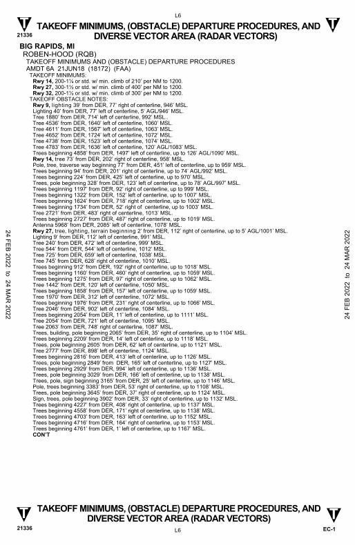
BIG RAPIDS, MI ROBEN-HOOD (RQB) TAKEOFF MINIMUMS AND (OBSTACLE) DEPARTURE PROCEDURES AMDT 6A 21JUN18 (18172) (FAA)
TAKEOFF MINIMUMS: Rwy 14, 200-1¼ or std. w/ min. climb of 210’ per NM to 1200. Rwy 27, 300-1½ or std. w/ min. climb of 400’ per NM to 1200. Rwy 32, 200-1½ or std. w/ min. climb of 300’ per NM to 1200.
TAKEOFF OBSTACLE NOTES: Rwy 9, lighting 39’ from DER, 77’ right of centerline, 946’ MSL. Lighting 40’ from DER, 77’ left of centerline, 5‘ AGL/946’ MSL. Tree 1880’ from DER, 714’ left of centerline, 992’ MSL.. Tree 4536’ from DER, 1640’ left of centerline, 1060’ MSL. Tree 4611’ from DER, 1567’ left of centerline, 1063’ MSL. Tree 4652’ from DER, 1724’ left of centerline, 1072’ MSL. Tree 4738’ from DER, 1523’ left of centerline, 1074’ MSL. Tree 4783’ from DER, 1636’ left of centerline, 120’ AGL/1083’ MSL. Trees beginning 4858’ from DER, 1497’ left of centerline, up to 126’ AGL/1090’ MSL. Rwy 14, tree 73’ from DER, 202’ right of centerline, 958’ MSL. Pole, tree, traverse way beginning 77’ from DER, 451’ left of centerline, up to 959’ MSL. Trees beginning 94’ from DER, 201’ right of centerline, up to 74’ AGL/992’ MSL. Trees beginning 224’ from DER, 425’ left of centerline, up to 970’ MSL. Trees, pole beginning 328’ from DER, 123’ left of centerline, up to 78’ AGL/997’ MSL. Trees beginning 1197’ from DER, 92’ right of centerline, up to 999’ MSL. Trees beginning 1322’ from DER, 152’ left of centerline, up to 1007’ MSL. Trees beginning 1624’ from DER, 718’ right of centerline, up to 1002’ MSL. Trees beginning 1734’ from DER, 52’ right of centerline, up to 1003’ MSL. Tree 2721’ from DER, 483’ right of centerline, 1013’ MSL. Trees beginning 2727’ from DER, 487’ right of centerline, up to 1019’ MSL. Antenna 5968’ from DER, 2085’ left of centerline, 1078’ MSL. Rwy 27, tree, lighting, terrain beginning 2’ from DER, 112’ right of centerline, up to 5’ AGL/1001’ MSL. Lighting 9‘ from DER, 112’ left of centerline, 991’ MSL. Tree 240’ from DER, 472’ left of centerline, 999’ MSL. Tree 544’ from DER, 544’ left of centerline, 1012’ MSL. Tree 725’ from DER, 659’ left of centerline, 1038’ MSL. Tree 745’ from DER, 628’ right of centerline, 1010’ MSL. Trees beginning 912’ from DER, 192’ right of centerline, up to 1018’ MSL. Trees beginning 1160’ from DER, 460’ right of centerline, up to 1059’ MSL. Trees beginning 1275’ from DER, 97’ right of centerline, up to 1062’ MSL. Tree 1442’ from DER, 120’ left of centerline, 1050’ MSL. Trees beginning 1858’ from DER, 157’ left of centerline, up to 1059’ MSL. Tree 1970’ from DER, 312’ left of centerline, 1072’ MSL. Trees beginning 1976‘ from DER, 231’ right of centerline, up to 1066’ MSL. Tree 2046’ from DER, 902’ left of centerline, 1084’ MSL. Trees beginning 2054’ from DER, 11’ left of centerline, up to 1111’ MSL. Tree 2054’ from DER, 721’ left of centerline, 1095’ MSL. Tree 2063’ from DER, 748’ right of centerline, 1087’ MSL. Trees, building, pole beginning 2065’ from DER, 35’ right of centerline, up to 1104’ MSL. Trees beginning 2209’ from DER, 14’ left of centerline, up to 1118’ MSL. Trees, pole beginning 2605’ from DER, 62’ left of centerline, up to 1121’ MSL. Tree 2777’ from DER, 898’ left of centerline, 1124’ MSL. Trees beginning 2816’ from DER, 413’ left of centerline, up to 1126’ MSL. Trees, pole beginning 2849’ from DER, 165‘ left of centerline, up to 1127’ MSL. Trees beginning 2929’ from DER, 994’ left of centerline, up to 1136’ MSL. Trees, pole beginning 3029’ from DER, 166’ left of centerline, up to 1138’ MSL. Trees, pole, sign beginning 3165’ from DER, 25‘ left of centerline, up to 1146’ MSL. Pole, trees beginning 3383’ from DER, 53’ right of centerline, up to 1108’ MSL. Trees, pole beginning 3645’ from DER, 37’ right of centerline, up to 1124’ MSL. Sign, trees, pole beginning 3902’ from DER, 33’ right of centerline, up to 1132’ MSL. Trees beginning 4227’ from DER, 408’ right of centerline, up to 1137’ MSL. Trees beginning 4558’ from DER, 171’ right of centerline, up to 1138’ MSL. Trees beginning 4703’ from DER, 163’ left of centerline, up to 1152’ MSL. Trees beginning 4716’ from DER, 164’ right of centerline, up to 1153’ MSL. Trees beginning 4761’ from DER, 1’ left of centerline, up to 1167’ MSL.
CON’T
24 FEB 2022 to 24 MAR
2022 24 F
EB 2
022
to 2
4 M
AR 2
022

TAKEOFF MINIMUMS, (OBSTACLE) DEPARTURE PROCEDURES, AND DIVERSE VECTOR AREA (RADAR VECTORS) 21336
L7
EC-1
TAKEOFF MINIMUMS, (OBSTACLE) DEPARTURE PROCEDURES, AND DIVERSE VECTOR AREA (RADAR VECTORS)
21336 L7
T T
T T
BIG RAPIDS, MI (CON’T) ROBEN-HOOD (RQB) (CON’T)
Rwy 27 (CON’T), trees beginning 4817’ from DER, 93’ right of centerline, up to 1155’ MSL. Trees beginning 5498’ from DER, 42’ left of centerline, up to 1171’ MSL. Tree 5546’ from DER, 636’ right of centerline, 1156’ MSL. Trees beginning 5627’ from DER, 202’ right of centerline, up to 1162’ MSL. Trees beginning 5716’ from DER, 2’ left of centerline, up to 1176’ MSL. Trees beginning 5854’ from DER, 258’ left of centerline, up to 1183’ MSL. Trees beginning 5858’ from DER, 13’ left of centerline, up to 94’ AGL/1185’ MSL. Trees beginning 6036’ from DER, 70’ right of centerline, up to 1167’ MSL. Trees beginning 1 NM from DER, 162’ right of centerline, up to 1168’ MSL. Vertical structure 1.2 NM from DER, 1391’ right of centerline, 100’ AGL/1196’ MSL. Rwy 32, terrain 20’ from DER, 242’ right of centerline, 933’ MSL. Trees, terrain beginning 28’ from DER, 342’ left of centerline, up to 936’ MSL. Tree 196’ from DER, 225’ left of centerline, 5’ AGL/938’ MSL. Tree 347’ from DER, 563’ left of centerline, 942’ MSL. Lighting 469’ from DER, 387’ right of centerline, 946’ MSL. Lighting 668’ from DER, 6’ right of centerline, 950’ MSL. Tree 696’ from DER, 676’ left of centerline, 951’ MSL. Wind indicator 993’ from DER, 519’ left of centerline, 11’ AGL/958’ MSL. Tree 1965’ from DER, 834’ right of centerline, 994’ MSL. Tree 2117’ from DER, 658’ right of centerline, 1002’ MSL. Trees beginning 2244’ from DER, 548’ right of centerline, up to 1012’ MSL. Trees beginning 2329’ from DER, 346’ right of centerline, up to 1030’ MSL. Trees beginning 2436’ from DER, 409’ right of centerline, up to 1031’ MSL.. Trees beginning 2529’ from DER, 125’ right of centerline, up to 1035’ MSL. Pole 2659’ from DER, 1104’ left of centerline, 1000’ MSL.. Trees, pole beginning 2666’ from DER, 44’ left of centerline, up to 1026‘ MSL.. Lighting, trees beginning 2979’ from DER, 613’ left of centerline, up to 59’ AGL/1027’ MSL. Trees beginning 3289‘ from DER, 401’ left of centerline, up to 1033’ MSL. Tree 4265’ from DER, 756’ left of centerline, 1041’ MSL. Trees beginning 4273’ from DER, 318’ left of centerline, up to 1053’ MSL. Tree 4503’ from DER, 703’ right of centerline, 1053‘ MSL. Trees beginning 4558’ from DER, 418’ left of centerline, up to 1088’ MSL. Trees beginning 4774’ from DER, 372’ left of centerline, up to 1092’ MSL. Trees beginning 4825’ from DER, 461’ left of centerline, up to 1096’ MSL. Tree 4929‘ from DER, 117’ right of centerline, 1067’ MSL. Trees beginning 4930’ from DER, 65’ left of centerline, up to 91’ AGL/1103’ MSL. Trees beginning 5038’ from DER, 277’ left of centerline, up to 92’ AGL/1107’ MSL. Tree 5057’ from DER, 367’ right of centerline, 1073’ MSL. Tree 5084’ from DER, 521’ right of centerline, 1075’ MSL. Tree 5096’ from DER, 165’ left of centerline, 88’ AGL/1110’ MSL. Trees beginning 5102’ from DER, 15’ left of centerline, up to 92’ AGL/1118‘ MSL. Trees beginning 5103’ from DER, 13’ right of centerline, up to 1100’ MSL. Tree 5375’ from DER, 279’ right of centerline, 1111’ MSL. Trees beginning 5393’ from DER, 50’ right of centerline, up to 99’ AGL/1113’ MSL. Trees beginning 5704’ from DER, 177’ left of centerline, up to 1119’ MSL. Tree 5862’ from DER, 142’ left of centerline, 1121‘ MSL. Trees beginning 5886’ from DER, 37’ left of centerline, up to 1122’ MSL. Trees beginning 5997’ from DER, 126’ left of centerline, up to 1127’ MSL. Trees beginning 6045’ from DER, 19’ left of centerline, up to 104’ AGL/1128’ MSL. Tree 1.2 NM from DER, 1914’ left of centerline, 1119’ MSL.
BOIS BLANC ISLAND, MI BOIS BLANC ISLAND (6Y1) TAKEOFF MINIMUMS AND (OBSTACLE) DEPARTURE PROCEDURES ORIG 13NOV14 (14317) (FAA)
TAKEOFF OBSTACLE NOTES: Rwy 10, trees beginning abeam DER, 144’ left of centerline, up to 100’ AGL/759’ MSL. Trees beginning abeam DER, 200’ right of centerline, up to 100’ AGL/759’ MSL. Trees beginning 1738’ from DER, left and right of centerline, up to 100’ AGL/759’ MSL. Rwy 28, trees beginning abeam DER, 217’ left of centerline, up to 100’ AGL/769’ MSL. Trees beginning abeam DER, 266’ right of centerline, up to 100’ AGL/799’ MSL. Vehicles on road beginning abeam DER, 170’ left of centerline, up to 15’ AGL/684’ MSL. Vehicles on road beginning 440’ from DER, crossing centerline from left to right, up to 15’ AGL/684’ MSL. Trees beginning 1590’ from DER, left and right of centerline up to 100’ AGL/799’ MSL.
24 FEB 2022 to 24 MAR
2022 24 F
EB 2
022
to 2
4 M
AR 2
022

TAKEOFF MINIMUMS, (OBSTACLE) DEPARTURE PROCEDURES, AND DIVERSE VECTOR AREA (RADAR VECTORS) 21336
L8
EC-1
TAKEOFF MINIMUMS, (OBSTACLE) DEPARTURE PROCEDURES, AND DIVERSE VECTOR AREA (RADAR VECTORS)
21336 L8
T T
T T
BOYNE CITY, MI BOYNE CITY MUNI (N98) TAKEOFF MINIMUMS AND (OBSTACLE) DEPARTURE PROCEDURES AMDT 1 20JUN19 (19171) (FAA)
TAKEOFF MINIMUMS: Rwy 9, 600-2¾ or std. w/min. climb of 503’ per NM to 1300. Rwy 27, std. w/min. climb of 238’ per NM to 1800 or 1200-2½ for VCOA.
DEPARTURE PROCEDURE: Rwy 9, climb heading 098° to 1200 before proceeding on course. Rwy 27, climb heading 278° to 1900 before turning left.
VCOA: Rwy 27, obtain ATC approval for VCOA when requesting IFR clearance. Climb in visual conditions to cross Boyne City Muni at or above 1700 before proceeding on course.
TAKEOFF OBSTACLE NOTES: Rwy 9, tree 10’ from DER, 180’ right of centerline, 681’ MSL. NAVAID 13’ from DER, 112’ left of centerline, 8’ AGL/661’ MSL. Tree 38’ from DER, 300’ left of centerline, 700’ MSL. Tree, vehicles on road beginning 98’ from DER, 246’ right of centerline, up to 704’ MSL. Tree 125’ from DER, 486’ left of centerline, 722’ MSL. Tree, pole, transmission line beginning 143’ from DER, 18’ left of centerline, up to 739’ MSL. Tree, sign, vehicles on road beginning 175’ from DER, 145’ right of centerline, up to 709’ MSL. Tree, vehicles on road, transmission line, pole beginning 431’ from DER, 176’ right of centerline, up to 731’ MSL. Trees beginning 893’ from DER, 22’ right of centerline, up to 732’ MSL. Trees beginning 2479’ from DER, 55’ left of centerline, up to 740’ MSL. Tree 2594’ from DER, 296’ right of centerline, 733’ MSL. Tree 2602’ from DER, 124’ right of centerline, 745’ MSL. Trees beginning 2612’ from DER, 82’ right of centerline, up to 755’ MSL. Tree 2618’ from DER, 83’ left of centerline, 751’ MSL. Trees beginning 2621’ from DER, 32’ left of centerline, up to 755’ MSL. Tree 2654’ from DER, 187’ left of centerline, 759’ MSL. Trees beginning 2654’ from DER, 58’ right of centerline, up to 762’ MSL. Trees beginning 2655’ from DER, 128’ left of centerline, up to 760’ MSL. Trees beginning 2681’ from DER, 53’ left of centerline, up to 761’ MSL. Trees beginning 2682’ from DER, 35’ right of centerline, up to 763’ MSL. Trees beginning 2709’ from DER, 158’ left of centerline, up to 766’ MSL. Trees beginning 2753’ from DER, 4’ left of centerline, up to 768’ MSL. Trees beginning 2820’ from DER, 2’ left of centerline, up to 773’ MSL. Trees beginning 3881’ from DER, 1083’ left of centerline, up to 823’ MSL. Trees beginning 3974’ from DER, 473’ left of centerline, up to 846’ MSL. Trees beginning 4075’ from DER, 322’ left of centerline, up to 861’ MSL. Tree 4481’ from DER, 849’ left of centerline, 868’ MSL. Trees beginning 4502’ from DER, 459’ left of centerline, up to 869’ MSL. Trees beginning 4641’ from DER, 443’ left of centerline, up to 879’ MSL. Trees beginning 4727’ from DER, 467’ left of centerline, up to 886’ MSL. Trees beginning 4834’ from DER, 691’ left of centerline, up to 887’ MSL. Trees beginning 4854’ from DER, 395’ left of centerline, up to 892’ MSL. Trees beginning 4935’ from DER, 286’ left of centerline, up to 909’ MSL. Trees beginning 5063’ from DER, 266’ left of centerline, up to 923’ MSL. Trees beginning 5086’ from DER, 299’ left of centerline, up to 936’ MSL. Trees beginning 5157’ from DER, 286’ left of centerline, up to 939’ MSL. Tree 5189’ from DER, 1178’ left of centerline, 940’ MSL. Trees beginning 5197’ from DER, 271’ left of centerline, up to 962’ MSL. Trees beginning 5292’ from DER, 213’ left of centerline, up to 988’ MSL. Tree, terrain beginning 5371’ from DER, on centerline, up to 997’ MSL. Tree 5605’ from DER, 1019’ right of centerline, 805’ MSL. Trees beginning 5812’ from DER, 11’ right of centerline, up to 814’ MSL. Trees beginning 5912’ from DER, 227’ right of centerline, up to 823’ MSL. Trees beginning 5933’ from DER, 307’ right of centerline, up to 831’ MSL. Trees beginning 5972’ from DER, 14’ right of centerline, up to 838’ MSL. Tree, terrain beginning 6023’ from DER, 14’ left of centerline, up to 1027’ MSL. Trees beginning 6066’ from DER, 2’ right of centerline, up to 858’ MSL. Tree, terrain beginning 1 NM from DER, 9’ left of centerline, up to 1036’ MSL. Trees beginning 1 NM from DER, 133’ right of centerline, up to 873’ MSL. Trees beginning 1.1 NM from DER, 151’ right of centerline, up to 894’ MSL. Trees beginning 1.1 NM from DER, 360’ right of centerline, up to 898’ MSL. Trees beginning 1.1 NM from DER, 1802’ left of centerline, up to 1050’ MSL. Tree 1.1 NM from DER, 540’ right of centerline, 912’ MSL. Trees beginning 1.1 NM from DER, 336’ right of centerline, up to 931’ MSL. Tree, terrain beginning 1.1 NM from DER, 224’ left of centerline, up to 1061’ MSL. Trees beginning 1.1 NM from DER, 139’ right of centerline, up to 954’ MSL. Tree, terrain beginning 1.1 NM from DER, 495’ left of centerline, up to 1074’ MSL. Tree, terrain beginning 1.2 NM from DER, 197’ left of centerline, up to 1087’ MSL. Tree 1.2 NM from DER, 339’ right of centerline, 972’ MSL. Tree, pole, transmission line, catenary beginning 1.2 NM from DER, 4’ right of centerline, up to 1007’ MSL. Tree, terrain, transmission line, pole beginning 1.2 NM from DER, 19’ left of centerline, up to 1127’ MSL. CON’T
24 FEB 2022 to 24 MAR
2022 24 F
EB 2
022
to 2
4 M
AR 2
022

TAKEOFF MINIMUMS, (OBSTACLE) DEPARTURE PROCEDURES, AND DIVERSE VECTOR AREA (RADAR VECTORS) 21336
L9
EC-1
TAKEOFF MINIMUMS, (OBSTACLE) DEPARTURE PROCEDURES, AND DIVERSE VECTOR AREA (RADAR VECTORS)
21336 L9
T T
T T
BOYNE CITY, MI (CON’T) BOYNE CITY MUNI (N98) (CON’T)
Rwy 9 (CON’T), trees beginning 1.3 NM from DER, 320’ right of centerline, up to 1011’ MSL. Trees beginning 1.3 NM from DER, 174’ right of centerline, up to 1027’ MSL. Trees beginning 1.3 NM from DER, 117’ right of centerline, up to 1036’ MSL. Trees beginning 1.3 NM from DER, 280’ left of centerline, up to 1130’ MSL. Trees beginning 1.3 NM from DER, 12’ left of centerline, up to 1141’ MSL. Trees beginning 1.4 NM from DER, 301’ right of centerline, up to 1040’ MSL. Trees beginning 1.4 NM from DER, 361’ left of centerline, up to 1146’ MSL. Trees beginning 1.4 NM from DER, 63’ right of centerline, up to 1051’ MSL. Trees beginning 1.4 NM from DER, 119’ left of centerline, up to 1147’ MSL. Tree 1.4 NM from DER, 289’ right of centerline, 1055’ MSL. Trees beginning 1.4 NM from DER, 30’ left of centerline, up to 1149’ MSL. Trees beginning 1.4 NM from DER, 2’ right of centerline, up to 1080’ MSL. Trees beginning 1.4 NM from DER, 70’ right of centerline, up to 1101’ MSL. Trees beginning 1.5 NM from DER, 786’ left of centerline, up to 1151’ MSL. Tree, terrain beginning 1.5 NM from DER, 47’ left of centerline, up to 1157’ MSL. Trees beginning 1.5 NM from DER, 700’ left of centerline, up to 1161’ MSL. Tree, terrain beginning 1.5 NM from DER, 13’ left of centerline, up to 1167’ MSL. Trees beginning 1.5 NM from DER, 52’ right of centerline, up to 1132’ MSL. Trees beginning 1.5 NM from DER, 8’ right of centerline, up to 1142’ MSL. Tree 2.2 NM from DER, 2497’ right of centerline, 1025’ MSL. Rwy 27, building 30’ from DER, 437’ right of centerline, 27’ AGL/678’ MSL. Tree 30’ from DER, 311’ right of centerline, 703’ MSL. Tree, building, pole, transmission line beginning 45’ from DER, 1’ right of centerline, up to 725’ MSL. Vehicles on road 64’ from DER, 203’ left of centerline, 672’ MSL. Pole 113’ from DER, 515’ left of centerline, 31’ AGL/690’ MSL. Building, pole, fence beginning 118’ from DER, 67’ left of centerline, up to 37’ AGL/694’ MSL. Tree, pole, building, transmission line beginning 244’ from DER, 13’ left of centerline, up to 728’ MSL. Tree, pole, transmission line, building beginning 435’ from DER, 19’ right of centerline, up to 726’ MSL. Trees beginning 649’ from DER, 24’ right of centerline, up to 739’ MSL. Tree, building, pole, transmission line beginning 719’ from DER, 1’ right of centerline, up to 743’ MSL. Tree, pole, transmission line beginning 1056’ from DER, 7’ left of centerline, up to 734’ MSL. Trees beginning 2774’ from DER, 58’ left of centerline, up to 743’ MSL.
BOYNE FALLS, MI BOYNE MOUNTAIN (BFA) TAKEOFF MINIMUMS AND (OBSTACLE) DEPARTURE PROCEDURES AMDT 4 29MAY14 (14149) (FAA)
TAKEOFF MINIMUMS: Rwy 17, std w/min. climb of 490’ per NM to 1400 or 1300-2½ for climb in visual conditions. Rwy 35, std w/min. climb of 310’ per NM to 1400 or 1300-2½ for climb in visual conditions.
DEPARTURE PROCEDURE: Rwy 17, climb heading 175° to 1400 before proceeding on course, or for climb in visual conditions cross Boyne Mountain airport at or above 1900 before proceeding on course. When executing VCOA, notify ATC prior to departure. Rwy 35, climb heading 355° to 1400 before proceeding on course, or for climb in visual conditions cross Boyne Mountain airport at or above 1900 before proceeding on course. When executing VCOA, notify ATC prior to departure.
TAKEOFF OBSTACLE NOTES: Rwy 17, vehicles on road beginning 10’ from DER, 93’ right of centerline, up to 15’ AGL/753’ MSL. Trees beginning 13’ from DER, 170’ left of centerline, up to 100’ AGL/854’ MSL. Vehicles on road beginning 402’ from DER, 16’ left of centerline, up to 15’ AGL/736’ MSL. Trees beginning 529’ from DER, 143’ right of centerline, up to 100’ AGL/838’ MSL. Trees beginning 2915’ from DER, 1028’ right of centerline, up to 100’ AGL/903’ MSL. Trees beginning 2.4 NM from DER, left and right of centerline, up to 100’ AGL/1231’ MSL. Rwy 35, vehicles on road beginning 28’ from DER, left and right of centerline, up to 15’ AGL/720’ MSL. Trees beginning 613’ from DER, 599’ left of centerline, up to 100’ AGL/805’ MSL. Trees beginning 1355’ from DER, left and right of centerline, up to 100’ AGL/805’ MSL. Trees beginning 2319’ from DER, 465’ right of centerline, up to 100’ AGL/797’ MSL. Multiple trees beginning 1.6 NM from DER, left and right of centerline, up to 100’ AGL/1069’ MSL. Trees beginning 1.7 NM from DER, left and right of centerline, up to 100’ AGL/1091’ MSL. Trees beginning 1.8 NM from DER, left and right of centerline, up to 100’ AGL/1124’ MSL. Multiple trees beginning 1.9 NM from DER, left and right of centerline, up to 100’ AGL/1127’ MSL. Multiple trees beginning 2.1 NM from DER, left and right of centerline, up to 100’ AGL/1161’ MSL.
24 FEB 2022 to 24 MAR
2022 24 F
EB 2
022
to 2
4 M
AR 2
022
TAKEOFF MINIMUMS, (OBSTACLE) DEPARTURE PROCEDURES, AND DIVERSE VECTOR AREA (RADAR VECTORS) 21336
L10
EC-1
TAKEOFF MINIMUMS, (OBSTACLE) DEPARTURE PROCEDURES, AND DIVERSE VECTOR AREA (RADAR VECTORS)
21336 L10
T T
T T
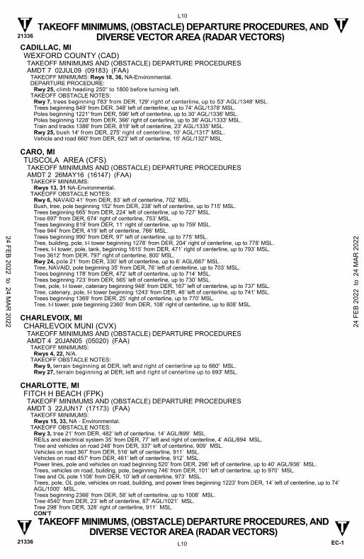
CADILLAC, MI WEXFORD COUNTY (CAD) TAKEOFF MINIMUMS AND (OBSTACLE) DEPARTURE PROCEDURES AMDT 7 02JUL09 (09183) (FAA)
TAKEOFF MINIMUMS: Rwys 18, 36, NA-Environmental. DEPARTURE PROCEDURE:
Rwy 25, climb heading 250° to 1800 before turning left. TAKEOFF OBSTACLE NOTES:
Rwy 7, trees beginning 783' from DER, 129' right of centerline, up to 53' AGL/1348' MSL. Trees beginning 849' from DER, 348' left of centerline, up to 74' AGL/1378' MSL. Poles beginning 1221' from DER, 596' left of centerline, up to 30' AGL/1336' MSL. Poles beginning 1228' from DER, 366' right of centerline, up to 38' AGL/1333' MSL. Train and tracks 1386' from DER, 819' left of centerline, 23' AGL/1335' MSL. Rwy 25, bush 14' from DER, 275' right of centerline, 10' AGL/1317' MSL. Vehicle and road 660' from DER, 623' left of centerline, 15' AGL/1327' MSL.
CARO, MI TUSCOLA AREA (CFS) TAKEOFF MINIMUMS AND (OBSTACLE) DEPARTURE PROCEDURES AMDT 2 26MAY16 (16147) (FAA)
TAKEOFF MINIMUMS: Rwys 13, 31 NA-Environmental.
TAKEOFF OBSTACLE NOTES: Rwy 6, NAVAID 41’ from DER, 83’ left of centerline, 702’ MSL. Bush, tree, pole beginning 152’ from DER, 238’ left of centerline, up to 715’ MSL. Trees beginning 665’ from DER, 224’ left of centerline, up to 727’ MSL. Tree 697’ from DER, 674’ right of centerline, 753’ MSL. Trees beginning 819’ from DER, 11’ right of centerline, up to 759’ MSL. Tree 944’ from DER, 419’ left of centerline, 766’ MSL. Trees beginning 990’ from DER, 97’ left of centerline, up to 775’ MSL. Tree, building, pole, t-l tower beginning 1278’ from DER, 204’ right of centerline, up to 778’ MSL. Trees, t-l tower, pole, tank, beginning 1615’ from DER, 471’ right of centerline, up to 793’ MSL. Tree 3612’ from DER, 797’ right of centerline, 800’ MSL. Rwy 24, pole 21’ from DER, 330’ left of centerline, up to 6’ AGL/687’ MSL. Tree, NAVAID, pole beginning 35‘ from DER, 76’ left of centerline, up to 703’ MSL. Trees beginning 178’ from DER, 472’ left of centerline, up to 714’ MSL. Trees beginning 723’ from DER, 565’ left of centerline, up to 730’ MSL. Tree, pole, t-l tower, catenary beginning 948’ from DER, 167’ left of centerline, up to 737’ MSL. Tree, catenary, pole, t-l tower beginning 1243’ from DER, 46’ left of centerline, up to 741’ MSL. Trees beginning 1369’ from DER, 25’ right of centerline, up to 770’ MSL. Tree, t-l tower, pole beginning 2360’ from DER, 108’ right of centerline, up to 808’ MSL.
CHARLEVOIX, MI CHARLEVOIX MUNI (CVX) TAKEOFF MINIMUMS AND (OBSTACLE) DEPARTURE PROCEDURES AMDT 4 20JAN05 (05020) (FAA)
TAKEOFF MINIMUMS: Rwys 4, 22, N/A.
TAKEOFF OBSTACLE NOTES: Rwy 9, terrain beginning at DER, left and right of centerline up to 660' MSL. Rwy 27, terrain beginning at DER, left and right of centerline up to 693' MSL.
CHARLOTTE, MI FITCH H BEACH (FPK) TAKEOFF MINIMUMS AND (OBSTACLE) DEPARTURE PROCEDURES AMDT 3 22JUN17 (17173) (FAA)
TAKEOFF MINIMUMS: Rwys 15, 33, NA - Environmental.
TAKEOFF OBSTACLE NOTES: Rwy 3, tree 21’ from DER, 482’ left of centerline, 14’ AGL/899’ MSL. REILs and electrical system 35’ from DER, 77’ left and right of centerline, 4’ AGL/894 MSL. Tree and vehicles on road 248’ from DER, 337’ left of centerline, 909’ MSL. Vehicles on road 367’ from DER, 516’ left of centerline, 911’ MSL. Vehicles on road 457’ from DER, 461’ left of centerline, 912’ MSL. Power lines, pole and vehicles on road beginning 520’ from DER, 298’ left of centerline, up to 40’ AGL/936’ MSL. Trees, vehicles on road, building, pole, beginning 746’ from DER, 101’ left of centerline, up to 970’ MSL. Tree and OL pole 1108’ from DER, 10’ left of centerline, 973’ MSL. Trees, pole, OL pole, vehicles on road, building, and power lines beginning 1223’ from DER, 14’ left of centerline, up to 74’ AGL/1000’ MSL. Trees beginning 2366’ from DER, 58’ left of centerline, up to 1008’ MSL. Tree 4540’ from DER, 23’ left of centerline, 87’ AGL/1021’ MSL. Tree 298’ from DER, 328’ right of centerline, 911’ MSL.
CON’T
24 FEB 2022 to 24 MAR
2022 24 F
EB 2
022
to 2
4 M
AR 2
022

TAKEOFF MINIMUMS, (OBSTACLE) DEPARTURE PROCEDURES, AND DIVERSE VECTOR AREA (RADAR VECTORS) 21336
L11
EC-1
TAKEOFF MINIMUMS, (OBSTACLE) DEPARTURE PROCEDURES, AND DIVERSE VECTOR AREA (RADAR VECTORS)
21336 L11
T T
T T
CHARLOTTE, MI (CON’T) FITCH H BEACH (FPK) (CON’T)
Rwy 3 (CON’T), pole and tree 465’ from DER, 264’ right of centerline, 935’ MSL. Pole 637’ from DER, 546’ right of centerline, 936’ MSL. Pole and trees beginning 676’ from DER, 137’ right of centerline, up to 38’ AGL/938’ MSL. Pole and tree 841’ from DER, 79’ right of centerline, 36’ AGL/939’ MSL. Poles and tree, beginning 969’ from DER, 476’ right of centerline, up to 35’ AGL/940’ MSL. Pole 1003’ from DER, 436’ right of centerline, 35’ AGL/941’ MSL. Pole, building and vehicles on road beginning 1135’ from DER, 108’ right of centerline, up to 944’ MSL. Pole, tree and vehicles on road beginning 1235’ from DER, 16’ right of centerline, up to 35’ AGL/945’ MSL. Sign and pole 1332’ from DER, 119’ right of centerline, 949’ MSL. Pole, building, power lines and vehicles on road beginning 1430’ from DER, 13’ right of centerline, up to 35’ AGL/953’ MSL. Sign, vehicles on road and building beginning 1642’ from DER, 105’ right of centerline, up to 37’ AGL/958’ MSL. Building, pole, power lines and vehicles on road beginning 1721’ from DER, 72’ right of centerline, up to 35’ AGL/959’ MSL. Pole and building 1814’ from DER, 500’ right of centerline, 43’ AGL/968’ MSL. Sign, vehicles on road, pole, tree and power lines beginning 1842’ from DER, 185’ right of centerline, up to 971’ MSL. Tree and pole 2181’ from DER, 119’ right of centerline, 991’ MSL. Tree and pole 2292’ from DER, 105’ right of centerline, 993’ MSL. Trees beginning 2426’ from DER, 88’ right of centerline, up to 1000’ MSL. Trees beginning 2487’ from DER, 836’ right of centerline, up to 1008’ MSL. Tree, power lines and pole beginning 2542’ from DER, 25’ right of centerline, up to 1010’ MSL. Trees, antenna and tower beginning 2663’ from DER, 35’ right of centerline, up to 94’ AGL/1026’ MSL. Rwy 21, trees beginning 17’ from DER, 427’ right of centerline, up to 53’ AGL/929’ MSL. REILs and electrical system 33’ from DER, 77’ left and right of centerline, 5’ AGL/884’ MSL. Trees beginning 941’ from DER, 182’ right of centerline, up to 935’ MSL. Trees beginning 1042’ from DER, 414’ right of centerline, up to 944’ MSL. Tree, powerlines and pole beginning 1046’ from DER, 536’ right of centerline, up to 950’ MSL. Trees beginning 2319’ from DER, 269’ right of centerline, up to 952’ MSL. Trees beginning 2453’ from DER, 682’ right of centerline, up to 976’ MSL. Trees beginning 2554’ from DER, 53’ right of centerline, up to 982’ MSL. Tree 34’ from DER, 284’ left of centerline, 889’ MSL. Tower, airport beacon, pole, powerlines and tree beginning 489’ from DER, 553’ left of centerline, up to 80’ AGL/964’ MSL
CHEBOYGAN, MI CHEBOYGAN COUNTY (SLH) TAKEOFF MINIMUMS AND (OBSTACLE) DEPARTURE PROCEDURES AMDT 3A 13SEP18 (18256) (FAA)
TAKEOFF OBSTACLE NOTES: Rwy 10, tree 96’ from DER, 379’ left of centerline, 643’ MSL. Trees beginning 409’ from DER, 429’ left of centerline, up to 662’ MSL. Tree 961’ from DER, 598’ right of centerline, 670’ MSL. Tree 1180’ from DER, 503’ left of centerline, 663’ MSL. Tree 1221’ from DER, 431’ left of centerline, 667’ MSL. Tree 1268’ from DER, 357’ left of centerline, 669’ MSL. Trees beginning 1282’ from DER, 189’ left of centerline, up to 670’ MSL. Trees beginning 1300’ from DER, 288’ right of centerline, up to 673’ MSL. Tree 1451’ from DER, 295’ left of centerline, 675’ MSL. Rwy 17, trees beginning 77’ from DER, 47’ right of centerline, up to 100’ AGL/750’ MSL. Trees beginning 187’ from DER, 31’ left of centerline, up to 100’ AGL/747’ MSL. Trees beginning 1417’ from DER, 1’ left of centerline, up to 100’ AGL/750’ MSL. Trees beginning 1838’ from DER, 28’ right of centerline, up to 100’ AGL/753’ MSL. Trees beginning 3306’ from DER, 10’ right of centerline, up to 100’ AGL/757’ MSL. Rwy 28, tree, vehicles on traverse way beginning 74’ from DER, 407’ left of centerline, up to 670’ MSL. Tree 443’ from DER, 429’ right of centerline, 680’ MSL. Tree 479’ from DER, 389’ left of centerline, 702’ MSL. Tree 548’ from DER, 400’ right of centerline, 693’ MSL. Trees beginning 1212’ from DER, 570’ left of centerline, up to 711’ MSL. Trees beginning 1534’ from DER, 184’ left of centerline, up to 724’ MSL. Trees beginning 1561’ from DER, 93’ right of centerline, up to 718’ MSL. Trees beginning 2059’ from DER, 354’ right of centerline, up to 727’ MSL. Tree 2826’ from DER, 769’ right of centerline, 732’ MSL. Trees beginning 2980’ from DER, 22’ left of centerline, up to 734’ MSL. Tree 3901’ from DER, 506’ right of centerline, 745’ MSL. Rwy 35, tree 47’ from DER, 454’ right of centerline, 100’ AGL/704’ MSL. Tree 103’ from DER, 249’ right of centerline, 100’ AGL/707’ MSL. Trees beginning 158’ from DER, 24’ right of centerline, up to 100’ AGL/711’ MSL. Tree 213’ from DER, 162’ left of centerline, 100’ AGL/714’ MSL. Trees beginning 268’ from DER, 5’ left of centerline, up to 100’ AGL/717’ MSL.
24 FEB 2022 to 24 MAR
2022 24 F
EB 2
022
to 2
4 M
AR 2
022

TAKEOFF MINIMUMS, (OBSTACLE) DEPARTURE PROCEDURES, AND DIVERSE VECTOR AREA (RADAR VECTORS) 21336
L12
EC-1
TAKEOFF MINIMUMS, (OBSTACLE) DEPARTURE PROCEDURES, AND DIVERSE VECTOR AREA (RADAR VECTORS)
21336 L12
T T
T T
CLARE, MI CLARE MUNI (48D) TAKEOFF MINIMUMS AND (OBSTACLE) DEPARTURE PROCEDURES AMDT 2 19SEP13 (13262) (FAA)
TAKEOFF MINIMUMS: Rwy 9, 300-1 or std. w/min. climb of 371’ per NM to 1100.
TAKEOFF OBSTACLE NOTES: Rwy 4, bush 24’ from DER, 131’ left of centerline, 8’ AGL/859’ MSL. Trees beginning 495’ from DER, 431’ right of centerline, up to 56’ AGL/897’ MSL. Pole and trees beginning 728’ from DER, 629’ left of centerline, up to 55’ AGL/906’ MSL. Tree 1158’ from DER, 166’ left of centerline, 48’ AGL/889’ MSL. Trees beginning 1693’ from DER, 607’ right of centerline, up to 67’ AGL/908’ MSL. Trees beginning 1668’ from DER, 111’ left of centerline, up to 114’ AGL/955’ MSL. Rwy 9, vehicle on road 7’ from DER, 92’ left of centerline, 15’ AGL/834’ MSL. Vehicle on road 229’ from DER, crossing centerline, 15’ AGL/834’ MSL. Buildings beginning 394’ from DER, 275’ right of centerline, up to 30’ AGL/849’ MSL. Trees beginning 81’ from DER, 417’ right of centerline, up to 45’ AGL/864’ MSL. Trees beginning 1894’ from DER, crossing centerline, up to 130’ AGL/989’ MSL. Rwy 22, terrain 38’ from DER, 486’ right of centerline, 828’ MSL. Light 39’ from DER, 111’ right of centerline, 4’ AGL/829’ MSL. Light 40’ from DER, 111’ left of centerline, 4’ AGL/828’ MSL. Windsock 373’ from DER, 559’ right of centerline, 34’ AGL/855’ MSL. Trees beginning 1033’ from DER, crossing centerline, up to 129’ AGL/934’ MSL. Rwy 27, building 290’ from DER, 574’ right of centerline, 20’ AGL/851’ MSL. Antenna 329’ from DER, 399’ right of centerline, 32’ AGL/863’ MSL. Building 434’ from DER, 552’ right of centerline, 21’ AGL/852’ MSL. Vehicle on road 532’ from DER, 516’ right of centerline, 15’ AGL/854’ MSL. Trees beginning 566’ from DER, 238‘ right of centerline, up to 98’ AGL/918’ MSL. Trees beginning 411’ from DER, 212’ left of centerline, up to 95’ AGL/906’ MSL. Trees beginning 1261’ from DER, 462’ right of centerline, up to 124’ AGL/932’ MSL. Trees beginning 2372’ from DER, 230’ left of centerline, up to 109’ AGL/930’ MSL.
COLDWATER, MI BRANCH COUNTY MEML (OEB) TAKEOFF MINIMUMS AND (OBSTACLE) DEPARTURE PROCEDURES AMDT 4 10APR08 (21224) (FAA)
TAKEOFF MINIMUMS: Rwys 16, 34, NA-Environmental.
TAKEOFF OBSTACLE NOTES: Rwy 4, vehicles on road and trees beginning 5' from DER, 92' right of centerline, up to 100' AGL/1059' MSL. Vehicles on road and trees beginning 347' from DER, 317' left of centerline, up to 100' AGL/1,059' MSL. Rwy 7, trees beginning 1246' from DER, 430' left of centerline, up to 100' AGL/1059' MSL. Vehicles on road and trees beginning 154' from DER, 315' right of centerline, up to 100' AGL/1039' MSL. Pole 336' from DER, 274' right of centerline, 18' AGL/977' MSL. Rwy 22, trains on railroad and trees beginning 769' from DER, 986' left to 945' right of centerline, up to 100' AGL/1099' MSL. Rwy 25, vehicles on road and trees beginning 1171' from DER, 394' left of centerline, up to 100' AGL/1,059' MSL. Trees beginning 732' from DER, 95' right of centerline, up to 100' AGL/1034' MSL.
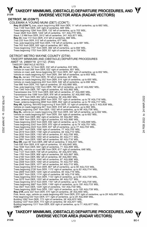
DETROIT, MI COLEMAN A YOUNG MUNI (DET) TAKEOFF MINIMUMS AND (OBSTACLE) DEPARTURE PROCEDURES AMDT 7A 24MAY18 (18144) (FAA)
TAKEOFF MINIMUMS: Rwy 25, std. w/ min. climb of 210’ per NM to 1000, or alternatively, with std. takeoff minimums and a 200’ per NM climb gradient, takeoff must occur no later than 1400’ prior to DER.
DEPARTURE PROCEDURE: Rwy 33, climb heading 328° to 1800 before turning left.
TAKEOFF OBSTACLE NOTES: Rwy 7, building, pole, tree, transmission line, stack beginning 290’ from DER, 65’ right of centerline, up to 77’ AGL/695’ MSL. Pole 459’ from DER, 138’ left of centerline, 31’ AGL/654’ MSL. Tree, lighting beginning 909’ from DER, 96‘ left of centerline, up to 680’ MSL. Rwy 15, building 449’ from DER, 317’ left of centerline, 16’ AGL/637’ MSL. Building, trees beginning 662’ from DER, 220’ left of centerline, up to 77’ AGL/695’ MSL. Building 803’ from DER, 521’ right of centerline, 656’ MSL. Tree 1058’ from DER, 367’ right of centerline, 659’ MSL. Tree 1527’ from DER, 445’ right of centerline, 669’ MSL. Tree 1990‘ from DER, 492’ right of centerline, 679’ MSL. Pole 3401’ from DER, 1110’ right of centerline, 106’ AGL/722’ MSL. Rwy 25, vehicle on road 1’ from DER, 125’ left of centerline, 650’ MSL. Building, vehicles on road, stack, beginning 48’ from DER, 39’ left of centerline, up to 36’ AGL/662’ MSL. Tree, pole beginning 456’ from DER, 132’ right of centerline, up to 658’ MSL. CON’T
24 FEB 2022 to 24 MAR
2022 24 F
EB 2
022
to 2
4 M
AR 2
022
TAKEOFF MINIMUMS, (OBSTACLE) DEPARTURE PROCEDURES, AND DIVERSE VECTOR AREA (RADAR VECTORS) 21336
L13
EC-1
TAKEOFF MINIMUMS, (OBSTACLE) DEPARTURE PROCEDURES, AND DIVERSE VECTOR AREA (RADAR VECTORS)
21336 L13
T T
T T
DETROIT, MI (CON’T) COLEMAN A YOUNG MUNI (DET) (CON’T)
Rwy 25 (CON’T), tree, stack beginning 908’ from DER, 11’ left of centerline, up to 683’ MSL. Tree 1109’ from DER, 325’ right of centerline, 685’ MSL. Trees beginning 1294’ from DER, 132’ left of centerline, up to 703‘ MSL. Tower 2828’ from DER, 1224’ left of centerline, 141’ AGL/770’ MSL. Stack 1.5 NM from DER, 2412’ left of centerline, 241’ AGL/871’ MSL. Rwy 33, tree 113’ from DER, 414’ left of centerline, 666’ MSL. Tree 233’ from DER, 512’ left of centerline, 677’ MSL. Tree, pole beginning 449’ from DER, 118’ left of centerline, up to 681’ MSL. Tree 743’ from DER, 505’ right of centerline, 661’ MSL. Trees beginning 1707’ from DER, 366’ left of centerline, up to 694’ MSL. Trees beginning 1753’ from DER, 83’ right of centerline, up to 709’ MSL.
DETROIT METRO WAYNE COUNTY (DTW) TAKEOFF MINIMUMS AND (OBSTACLE) DEPARTURE PROCEDURES AMDT 1A 24MAY18 (21112) (FAA)
TAKEOFF OBSTACLE NOTES: Rwy 3R, terrain 14’ from DER, 332’ left of centerline, 633’ MSL. Vehicle on road 358’ from DER, 522’ right of centerline, 651’ MSL. Vehicle on road, wall, fence beginning 361’ from DER, 387’ right of centerline, up to 652’ MSL. Vehicle on roads beginning 421’ from DER, 394’ left of centerline, up to 653’ MSL. Rwy 4L, terrain 179’ from DER, 78’ left of centerline, 647’ MSL. Vehicle on roads beginning 302’ from DER, 514’ right of centerline, up to 655’ MSL. Vehicle on roads beginning 403’ from DER, 546’ left of centerline, up to 656’ MSL. Tree 996’ from DER, 743’ right of centerline, 29’ AGL/668’ MSL. Tree, pole beginning 1183’ from DER, 765’ left of centerline, up to 43’ AGL/682’ MSL. Tree 1345’ from DER, 787’ right of centerline, 42’ AGL/682’ MSL. Transmission line 1515’ from DER, 826’ left of centerline, 47’ AGL/685’ MSL. Transmission line 1599’ from DER, 876’ left of centerline, 52’ AGL/690’ MSL. Tree 1971’ from DER, 852’ left of centerline, 56’ AGL/694’ MSL. Tower, antenna beginning 2694’ from DER, 757’ right of centerline, up to 78’ AGL/716’ MSL. Tower, antenna beginning 2858’ from DER, 852’ right of centerline, up to 79’ AGL/717’ MSL. Rwy 4R, lighting, NAVAID beginning 9’ from DER, 10’ right of centerline, up to 3’ AGL/638’ MSL. Vehicle on roads beginning 941’ from DER, 618’ left of centerline, up to 664’ MSL. Building beginning 3347’ from DER, 1302’ left of centerline, up to 98’ AGL/736’ MSL. Rwy 9L, vehicle on roads beginning 292’ from DER, 342’ left of centerline, up to 652’ MSL. Vehicle on roads beginning 601’ from DER, 354’ right of centerline, up to 652’ MSL. Tree 1699’ from DER, 882’ right of centerline, 59’ AGL/687’ MSL. Tree 1804’ from DER, 913’ right of centerline, 63’ AGL/690’ MSL. Trees beginning 2043’ from DER, 936’ right of centerline, up to 73’ AGL/699’ MSL. Trees beginning 2242’ from DER, 970’ right of centerline, up to 74’ AGL/701’ MSL. Trees beginning 2424’ from DER, 937’ left of centerline, up to 77’ AGL/704’ MSL. Tree 2461’ from DER, 1056’ right of centerline, 77’ AGL/705’ MSL. Tree 2519’ from DER, 1168’ right of centerline, 84’ AGL/710’ MSL. Tree 2632’ from DER, 1163’ left of centerline, 81’ AGL/708’ MSL. Tree 2788’ from DER, 1050’ left of centerline, 85’ AGL/711’ MSL. Tree 2891’ from DER, 1065’ left of centerline, 90’ AGL/716’ MSL. Rwy 9R, sign 60’ from DER, 288’ left of centerline, 5’ AGL/631’ MSL. Tree 538’ from DER, 618’ right of centerline, 19’ AGL/645’ MSL. Tree 1836’ from DER, 940’ right of centerline, 71’ AGL/695’ MSL. Rwy 21L, vehicle on road 586’ from DER, 617’ right of centerline, 648’ MSL. Tree 1121’ from DER, 738’ left of centerline, 39’ AGL/674’ MSL. Tree 1763’ from DER, 906’ right of centerline, 59’ AGL/687’ MSL. Tree 2160’ from DER, 982’ left of centerline, 68’ AGL/693’ MSL. Tree 2256’ from DER, 1040’ left of centerline, 67’ AGL/696’ MSL. Tree 2408‘ from DER, 1050’ left of centerline, 76’ AGL/707’ MSL. Tree 2548’ from DER, 1077’ left of centerline, 84’ AGL/715’ MSL. Trees beginning 2619’ from DER, 867’ left of centerline, up to 90’ AGL/723’ MSL. Trees beginning 2726’ from DER, 1172’ right of centerline, up to 83’ AGL/714’ MSL. Tree 2809’ from DER, 1245’ right of centerline, 85’ AGL/716’ MSL. Tree 2907’ from DER, 1174’ right of centerline, 86’ AGL/718’ MSL. Trees beginning 2933’ from DER, 1133’ right of centerline, up to 95’ AGL/728’ MSL. Tree 3275’ from DER, 1222’ left of centerline, 99’ AGL/727’ MSL. Trees beginning 3412’ from DER, 1161’ left of centerline, up to 107’ AGL/735’ MSL. Trees beginning 3687’ from DER, 1169’ right of centerline, up to 100’ AGL/733’ MSL. Tree 3921’ from DER, 1229’ right of centerline, 103’ AGL/734’ MSL. Trees beginning 3926’ from DER, 1351’ right of centerline, up to 109’ AGL/739’ MSL. Rwy 21R, pole 322’ from DER, 570’ right of centerline, 28’ AGL/655’ MSL. Pole, fence, sign, vehicle on roads beginning 450’ from DER, 570’ right of centerline, up to 29’ AGL/657’ MSL. Pole beginning 533’ from DER, 571’ right of centerline, up to 29’ AGL/658’ MSL. Building 1092’ from DER, 773’ right of centerline, 58’ AGL/670’ MSL. Building 1237’ from DER, 773’ right of centerline, 58’ AGL/671’ MSL. Building beginning 1311’ from DER, 829’ right of centerline, up to 71’ AGL/677’ MSL. CON’T
24 FEB 2022 to 24 MAR
2022 24 F
EB 2
022
to 2
4 M
AR 2
022

TAKEOFF MINIMUMS, (OBSTACLE) DEPARTURE PROCEDURES, AND DIVERSE VECTOR AREA (RADAR VECTORS) 21336
L14
EC-1
TAKEOFF MINIMUMS, (OBSTACLE) DEPARTURE PROCEDURES, AND DIVERSE VECTOR AREA (RADAR VECTORS)
21336 L14
T T
T T
DETROIT, MI (CON’T) DETROIT METRO WAYNE COUNTY (DTW) (CON’T)
Rwy 22L, lighting 10’ from DER, 5’ left of centerline, 1’ AGL/638’ MSL. NAVAID 79’ from DER, 412’ left of centerline, 4’ AGL/640’ MSL. Tree 3681’ from DER, 1384’ left of centerline, 103’ AGL/738’ MSL. Rwy 22R, terrain 19’ from DER, 438’ left of centerline, 649’ MSL. Terrain 150’ from DER, 86’ left of centerline,650’ MSL. Tree 1102’ from DER, 734’ right of centerline, 37’ AGL/681’ MSL. Tree 1859’ from DER, 854’ right of centerline, 60’ AGL/702’ MSL. Tree 1979’ from DER, 942’ right of centerline, 66’ AGL/706’ MSL. Tree 2386’ from DER, 892’ left of centerline, 75’ AGL/715’ MSL. Tree 3343’ from DER, 1361’ left of centerline, 97’ AGL/735’ MSL. Tree 3727‘ from DER, 1351’ left of centerline, 103’ AGL/741’ MSL. Rwy 27L, vehicle on road 491’ from DER, 600’ left of centerline, 650’ MSL. Pole 1011’ from DER, 698’ left of centerline, 27’ AGL/662’ MSL. Rwy 27R, NAVAID 11’ from DER, 55’ right of centerline, 2’ AGL/639’ MSL. NAVAID 11’ from DER, 54’ left of centerline, 2’ AGL/639’ MSL. Pole 14’ from DER, 441’ left of centerline, 19’ AGL/656’ MSL. Tower 4460’ from DER, 462‘ left of centerline, 106’ AGL/756’ MSL.
WILLOW RUN (YIP) TAKEOFF MINIMUMS AND (OBSTACLE) DEPARTURE PROCEDURES AMDT 10B 24MAY18 (18144) (FAA)
TAKEOFF MINIMUMS: Rwy 27, 300-1½ or std. w/ min. climb of 209’ per NM to 1000, or alternatively, with std. takeoff minimums and a normal 200’ per NM climb gradient, takeoff must occur no later than 1300’ prior to DER.
TAKEOFF OBSTACLE NOTES: Rwy 5R, electrical system beginning 5’ from DER, 56’ right of centerline, up to 3’ AGL/703’ MSL. Electrical system 5’ from DER, 56’ left of centerline, 3’ AGL/703’ MSL. Transmission line 1070’ from DER, 593’ left of centerline, 34’ AGL/731’ MSL. Transmission line 1180’ from DER, 492’ left of centerline, 36’ AGL/732’ MSL. Tree 1406’ from DER, 799’ left of centerline, 42’ AGL/741’ MSL. Tree 1591’ from DER, 902’ left of centerline, 50’ AGL/750’ MSL. Trees beginning 2193’ from DER, 1037’ right of centerline, up to 69’ AGL/762’ MSL. Tree 2344’ from DER, 1076’ left of centerline, 68’ AGL/769’ MSL. Rwy 5L, transmission line beginning 1390’ from DER, 817’ left of centerline, up to 39’ AGL/744’ MSL. Tree 1603’ from DER, 802’ left of centerline, 75’ AGL/780’ MSL. Trees beginning 1668’ from DER, 394’ left of centerline, up to 80‘ AGL/786’ MSL. Trees beginning 2745’ from DER, 1010’ left of centerline, up to 89’ AGL/791’ MSL. Tree 3407’ from DER, 967’ left of centerline, 95’ AGL/796’ MSL. Rwy 9, electrical system 10’ from DER, 88’ left of centerline, 2’ AGL/700’ MSL. Building, NAVAID beginning 150’ from DER, 487’ left of centerline, up to 18’ AGL/715’ MSL. Traverse way beginning 720’ from DER, 641’ right of centerline, up to 35’ AGL/736’ MSL. Tree 1036’ from DER, 550’ left of centerline, 35’ AGL/729’ MSL. Trees beginning 1113’ from DER, 763’ right of centerline, up to 52’ AGL/752’ MSL. Tree 1347’ from DER, 856’ left of centerline, 59’ AGL/754’ MSL. Trees beginning 1477’ from DER, 791’ left of centerline, up to 69’ AGL/762’ MSL. Tree 1692’ from DER, 774’ left of centerline, 77’ AGL/773’ MSL. Stack 1778’ from DER, 892’ right of centerline, 70’ AGL/770’ MSL. Tree 1889‘ from DER, 775’ left of centerline, 78’ AGL/774’ MSL. Trees beginning 2104’ from DER, 776’ left of centerline, up to 81’ AGL/776’ MSL. Trees beginning 2883’ from DER, 787’ left of centerline, up to 84’ AGL/780’ MSL. Tree 3773’ from DER, 737’ left of centerline, 100’ AGL/796’ MSL. Tree 3929’ from DER, 516’ left of centerline, 104’ AGL/799’ MSL. Rwy 23L, electrical system 4’ from DER, 69’ left of centerline, 3’ AGL/716’ MSL. Electrical system 5’ from DER, 89’ right of centerline, 2’ AGL/716’ MSL. Sign, tree, pole beginning 21’ from DER, 49’ left of centerline, up to 100’ AGL/816’ MSL. Sign 33’ from DER, 501’ right of centerline, 3’ AGL/717’ MSL. Trees, electrical system beginning 141’ from DER, 3’ right of centerline, up to 100’ AGL/816’ MSL. Trees beginning 886’ from DER, 39’ right of centerline, up to 100’ AGL/819’ MSL. Trees beginning 1095’ from DER, 4’ left of centerline, up to 100’ AGL/819’ MSL. Tree 1708’ from DER, 879’ right of centerline, 100’ AGL/822’ MSL. Trees beginning 1752’ from DER, 127’ right of centerline, up to 100’ AGL/826’ MSL. Trees beginning 1916’ from DER, 61’ right of centerline, up to 100’ AGL/829’ MSL. Trees beginning 2245’ from DER, 17’ right of centerline, up to 100’ AGL/832’ MSL. Trees beginning 2837’ from DER, 70’ left of centerline, up to 100’ AGL/822’ MSL. Trees beginning 3001’ from DER, 291’ left of centerline, up to 100’ AGL/832’ MSL. Trees beginning 3166’ from DER, 48’ left of centerline, up to 100’ AGL/835’ MSL. Rwy 23R, sign 61’ from DER, 252’ left of centerline, 3’ AGL/717’ MSL. Trees, pole, building beginning 82’ from DER, 14’ right of centerline, up to 100’ AGL/819’ MSL. Tree 126’ from DER, 140’ left of centerline, 100’ AGL/812’ MSL. Trees beginning 170’ from DER, 51’ left of centerline, up to 100’ AGL/816’ MSL. Trees, building beginning 783’ from DER, 9’ right of centerline, up to 100’ AGL/822’ MSL. Trees beginning 915’ from DER, 29’ left of centerline, up to 100‘ AGL/819’ MSL. Trees beginning 1780’ from DER, 250’ left of centerline, up to 100’ AGL/826’ MSL. CON’T
24 FEB 2022 to 24 MAR
2022 24 F
EB 2
022
to 2
4 M
AR 2
022

TAKEOFF MINIMUMS, (OBSTACLE) DEPARTURE PROCEDURES, AND DIVERSE VECTOR AREA (RADAR VECTORS) 21336
L15
EC-1
TAKEOFF MINIMUMS, (OBSTACLE) DEPARTURE PROCEDURES, AND DIVERSE VECTOR AREA (RADAR VECTORS)
21336 L15
T T
T T
DETROIT, MI (CON’T) WILLOW RUN (YIP) (CON’T)
Rwy 23R (CON’T), trees beginning 1857‘ from DER, 58’ right of centerline, up to 100’ AGL/829’ MSL. Trees beginning 1944’ from DER, 7’ left of centerline, up to 100’ AGL/829’ MSL. Trees, stack beginning 2273’ from DER, 14’ right of centerline, up to 100’ AGL/832’ MSL. Trees beginning 3358’ from DER, 51’ left of centerline, up to 100’ AGL/835’ MSL. Rwy 27, fence beginning 110’ from DER, 353’ right of centerline, up to 6’ AGL/722’ MSL. Tree 118’ from DER, 481‘ right of centerline, 25’ AGL/742’ MSL. Tree, fence beginning 181’ from DER, 353’ right of centerline, up to 26’ AGL/745’ MSL. Tree, fence beginning 200’ from DER, 353’ right of centerline, up to 52’ AGL/769’ MSL. Terrain, fence beginning 468’ from DER, 93’ left of centerline, up to 729’ MSL. Tree, pole beginning 503’ from DER, 212’ right of centerline, up to 51’ AGL/771’ MSL. Pole 768’ from DER, 102’ left of centerline, 26’ AGL/742’ MSL. Pole 841’ from DER, 174’ left of centerline, 27’ AGL/744’ MSL. Pole beginning 985’ from DER, 42’ left of centerline, up to 35’ AGL/752‘ MSL. Pole 1222’ from DER, 423’ left of centerline, 43’ AGL/760’ MSL. Pole 1243’ from DER, 38’ left of centerline, 44‘ AGL/761’ MSL. Pole, building beginning 1559’ from DER, 43’ left of centerline, up to 54’ AGL/772’ MSL. Building 1786‘ from DER, 865’ left of centerline, 55’ AGL/773’ MSL. Building beginning 1816’ from DER, 789’ left of centerline, up to 58’ AGL/777’ MSL. Building, pole beginning 1843’ from DER, 45’ left of centerline, up to 59’ AGL/778’ MSL. Tree 2836‘ from DER, 833’ right of centerline, 68’ AGL/789’ MSL. Tree 2869’ from DER, 985’ right of centerline, 75’ AGL/794’ MSL. Trees beginning 2910’ from DER, 1007’ right of centerline, up to 76’ AGL/795’ MSL. Building 2931’ from DER, 784’ left of centerline, 68’ AGL/789’ MSL. Transmission line 3710’ from DER, 390’ right of centerline, 90’ AGL/812’ MSL. Transmission line, catenary beginning 3961’ from DER, 775’ left of centerline, up to 101’ AGL/825’ MSL. Tree 4002’ from DER, 1392’ right of centerline, 85’ AGL/817’ MSL. Transmission line 4076’ from DER, 119’ left of centerline, 104’ AGL/830’ MSL. Tree 4482’ from DER, 471’ right of centerline, 104’ AGL/834’ MSL. Tower 1.1 NM from DER, 468’ left of centerline, 165’ AGL/903’ MSL.
DETROIT/GROSSE ILE, MI GROSSE ILE MUNI (ONZ) TAKEOFF MINIMUMS AND (OBSTACLE) DEPARTURE PROCEDURES AMDT 5A 24MAY18 (18144) (FAA)
TAKEOFF MINIMUMS: Rwy 35, 800 -1½ or std. w/ min. climb of 500’ per NM to 1100.
DEPARTURE PROCEDURE: Rwy 4, climb heading 037° to 1200 before turning left. Rwy 35, climb heading 006° to 1800 before turning left.
TAKEOFF OBSTACLE NOTES: Rwy 4, tree 12’ from DER, 390’ left of centerline, 615’ MSL. Tree, vegetation beginning 94’ from DER, 192’ right of centerline, up to 620’ MSL. Tree 106’ from DER, 497’ left of centerline, 629’ MSL. Tree, transmission line, pole beginning 137’ from DER, 350’ right of centerline, up to 655’ MSL. Tree 191’ from DER, 422’ left of centerline, 642’ MSL. Trees beginning 256’ from DER, 376’ left of centerline, up to 653’ MSL. Tree, building beginning 410’ from DER, 164‘ left of centerline, up to 672’ MSL. Trees beginning 720’ from DER, 279’ right of centerline, up to 660’ MSL. Trees beginning 903’ from DER, 20’ right of centerline, up to 661’ MSL. Trees beginning 974’ from DER, 148’ left of centerline, up to 673’ MSL. Trees beginning 1189’ from DER, 55’ right of centerline, up to 667’ MSL. Trees beginning 1490’ from DER, 38’ right of centerline, up to 676’ MSL. Trees beginning 1492’ from DER, 37’ left of centerline, up to 679’ MSL. Trees beginning 2083’ from DER, 155’ left of centerline, up to 697’ MSL. Trees beginning 2088’ from DER, 179‘ right of centerline, up to 685’ MSL. Tree 3459’ from DER, 210’ right of centerline, 687’ MSL. Trees beginning 3492’ from DER, 255’ left of centerline, up to 698’ MSL. Trees beginning 4123’ from DER, 611’ left of centerline, up to 700’ MSL. Tree 4453’ from DER, 411’ left of centerline, 702’ MSL. Tree 4610’ from DER, 877’ left of centerline, 713’ MSL. Rwy 17, tree 44’ from DER, 378’ right of centerline, 621’ MSL. Tree, fence beginning 64’ from DER, 218’ right of centerline, up to 622’ MSL. Tree 148’ from DER, 485’ left of centerline, 583’ MSL. Tree 164’ from DER, 540’ left of centerline, 595’ MSL. Trees beginning 275’ from DER, 395’ right of centerline, up to 643’ MSL. Tree 2311’ from DER, 991‘ left of centerline, 651’ MSL. Tree 2497’ from DER, 1103’ left of centerline, 671’ MSL. Trees beginning 2515’ from DER, 740’ left of centerline, up to 672’ MSL. Rwy 22, trees beginning 14’ from DER, 350’ left of centerline, up to 583’ MSL. Tree, fence beginning 369’ from DER, 517’ right of centerline, up to 607’ MSL. Trees beginning 516’ from DER, 385’ right of centerline, up to 621’ MSL. Tree 548’ from DER, 485’ right of centerline, 622’ MSL. CON’T
24 FEB 2022 to 24 MAR
2022 24 F
EB 2
022
to 2
4 M
AR 2
022

TAKEOFF MINIMUMS, (OBSTACLE) DEPARTURE PROCEDURES, AND DIVERSE VECTOR AREA (RADAR VECTORS) 21336
L16
EC-1
TAKEOFF MINIMUMS, (OBSTACLE) DEPARTURE PROCEDURES, AND DIVERSE VECTOR AREA (RADAR VECTORS)
21336 L16
T T
T T
DETROIT/GROSSE ILE, MI (CON’T) GROSSE ILE MUNI (ONZ) (CON’T)
Rwy 22 (CON’T), tree 765’ from DER, 407’ right of centerline, 643’ MSL. Trees beginning 787’ from DER, 180’ right of centerline, up to 653’ MSL. Trees beginning 903’ from DER, 563’ right of centerline, up to 662’ MSL. Trees beginning 1083’ from DER, 413’ right of centerline, up to 665’ MSL. Tree 1382’ from DER, 614’ right of centerline, 667’ MSL. Trees beginning 1545’ from DER, 624’ right of centerline, up to 683’ MSL. Trees beginning 1907’ from DER, 763’ right of centerline, up to 691’ MSL. Rwy 35, terrain 1’ from DER, 101’ right of centerline, 583’ MSL. Tree, building, fence beginning 26’ from DER, 165‘ left of centerline, up to 663’ MSL. Terrain 158’ from DER, 227’ right of centerline, 586’ MSL. Building 450’ from DER, 515’ right of centerline, 9’ AGL/595’ MSL. Tree 519’ from DER, 591’ right of centerline, 612’ MSL. Tree, road, building beginning 663’ from DER, 144’ right of centerline, up to 615’ MSL. Tree, building beginning 684’ from DER, 224‘ left of centerline, up to 668’ MSL. Tree, pole, transmission line, building beginning 823’ from DER, 15’ left of centerline, up to 675’ MSL. Transmission line, pole beginning 934’ from DER, 508’ right of centerline, up to 38’ AGL/627‘ MSL. Pole, transmission line beginning 1004’ from DER, 379’ right of centerline, up to 628’ MSL. Tree, transmission line, pole beginning 1073’ from DER, 135’ right of centerline, up to 635’ MSL. Tree, pole, transmission line beginning 1083‘ from DER, 14’ right of centerline, up to 636’ MSL. Trees beginning 1149’ from DER, 127’ right of centerline, up to 641’ MSL. Trees beginning 1215’ from DER, 35’ right of centerline, up to 658’ MSL. Trees beginning 1362’ from DER, 236‘ right of centerline, up to 663’ MSL. Trees beginning 2148’ from DER, 62’ right of centerline, up to 668’ MSL. Trees beginning 3337’ from DER, 467’ right of centerline, up to 678’ MSL.
DOWAGIAC, MI DOWAGIAC MUNI (C91) TAKEOFF MINIMUMS AND (OBSTACLE) DEPARTURE PROCEDURES AMDT 5A 26MAR20 (20086) (FAA)
TAKEOFF MINIMUMS: Rwys 4, 22, NA-Environmental.
TAKEOFF OBSTACLE NOTES: Rwy 9, building, 258' from DER, 549' right of centerline, 26' AGL/778' MSL. Multiple poles beginning 372' from DER, 432' right of centerline, up to 42' AGL/795' MSL. Antenna, 459' from DER, 367' right of centerline, 35' AGL/787' MSL. Antenna, 615' from DER, 341' right of centerline, 35' AGL/775' MSL. Multiple poles beginning 654' from DER, 341' left of centerline, up to 48' AGL/779' MSL. Trees beginning 667' from DER, 21' left of centerline, up to 77' AGL/839' MSL. Trees beginning 864' from DER, 7' right of centerline, up to 121' AGL/879' MSL. Rwy 27, trees beginning 21' from DER, 33' right of centerline, up to 93' AGL/828' MSL. Trees beginning 154' from DER, 112' left of centerline, up to 111' AGL/837' MSL.
DRUMMOND ISLAND, MI DRUMMOND ISLAND (DRM) TAKEOFF MINIMUMS AND (OBSTACLE) DEPARTURE PROCEDURES AMDT 1 31MAY12 (12152) (FAA)
TAKEOFF MINIMUMS: Rwys 1,19, NA - environmental. Rwy 8, 300-1 or std. w/min. climb of 449'per NM to 1000.
TAKEOFF OBSTACLE NOTES: Rwy 8, fence beginning 72' from DER, left and right of centerline, up to 5' AGL/664' MSL. Vehicle on road beginning 199' from DER, left and right of centerline, up to 15' AGL/675' MSL. Buildings beginning 11' from DER, left and right of centerline, up to 20' AGL/679' MSL. Poles 123' from DER, 182' left of centerline, up to 30' AGL/689' MSL. Trees beginning 91' from DER, left and right of centerline, up to 100' AGL/860' MSL. Rwy 26, trees beginning 42' from DER, left and right of centerline, up to 100' AGL/809' MSL. Buildings beginning 102' from DER, 87' left of centerline, up to 20' AGL/669' MSL.
EAST TAWAS, MI IOSCO COUNTY (6D9) TAKEOFF MINIMUMS AND (OBSTACLE) DEPARTURE PROCEDURES AMDT 1 25JUL13 (13206) (FAA)
TAKEOFF OBSTACLE NOTES: Rwy 8, trees beginning at DER, 400’ left and right of centerline, up to 100’ AGL/704’ MSL. Vehicles on roadway 17’ from DER, 306’ left of centerline, up to 15’ AGL/619’ MSL. Train 113’ from DER, 510’ right of centerline, up to 23’ AGL/627’ MSL. Rwy 26, trees beginning at DER, 100’ left and right of centerline, up to 100’ AGL/714’ MSL.
24 FEB 2022 to 24 MAR
2022 24 F
EB 2
022
to 2
4 M
AR 2
022

TAKEOFF MINIMUMS, (OBSTACLE) DEPARTURE PROCEDURES, AND DIVERSE VECTOR AREA (RADAR VECTORS) 21336
L17
EC-1
TAKEOFF MINIMUMS, (OBSTACLE) DEPARTURE PROCEDURES, AND DIVERSE VECTOR AREA (RADAR VECTORS)
21336 L17
T T
T T
ESCANABA, MI DELTA COUNTY (ESC) TAKEOFF MINIMUMS AND (OBSTACLE) DEPARTURE PROCEDURES AMDT 1 13SEP18 (18256) (FAA)
TAKEOFF MINIMUMS: Rwy 1, 400-2¼ or std. w/min. climb gradient of 265 feet per NM to 1100.
TAKEOFF OBSTACLE NOTES: Rwy 1, vehicles on road beginning 40’ from DER, 40’ right of centerline, up to 15’ AGL/621’ MSL. Tower 1.7 NM from DER, 2363’ left of centerline, 293’ AGL/965’ MSL. Rwy 9, vehicles on road beginning 1’ from DER, 272’ right of centerline, up to 607’ MSL. Trees beginning 1753’ from DER, 417’ right of centerline, up to 648’ MSL. Tree 1859’ from DER, 561’ right of centerline, 654’ MSL. Trees beginning 1869’ from DER, 54’ right of centerline, up to 656’ MSL. Tree 2024’ from DER, 444’ left of centerline, 646’ MSL. Rwy 19, fence beginning 131’ from DER, 402’ right of centerline, up to 9’ AGL/599’ MSL. Pole 247’ from DER, 562‘ right of centerline, 28’ AGL/618’ MSL. Tree 321’ from DER, 350’ left of centerline, 606’ MSL. Trees beginning 367’ from DER, 524’ right of centerline, up to 646’ MSL. Tree 374’ from DER, 454’ left of centerline, 643’ MSL. Trees beginning 447’ from DER, 383’ left of centerline, up to 650’ MSL. Trees beginning 463’ from DER, 383’ left of centerline, up to 660’ MSL. Trees beginning 543’ from DER, 500’ right of centerline, up to 652’ MSL. Trees beginning 640’ from DER, 19’ left of centerline, up to 664’ MSL. Trees beginning 671’ from DER, 19’ right of centerline, up to 673’ MSL.
FLINT, MI BISHOP INTL (FNT) TAKEOFF MINIMUMS AND (OBSTACLE) DEPARTURE PROCEDURES AMDT 5 21FEB02 (02052) (FAA)
TAKEOFF OBSTACLE NOTES: Rwy 18, trees 1200' from DER, 500' right of centerline, 65' AGL/863' MSL.
FRANKFORT, MI FRANKFORT DOW MEML FLD (FKS) TAKEOFF MINIMUMS AND (OBSTACLE) DEPARTURE PROCEDURES AMDT 3 10MAR11 (21112) (FAA)
TAKEOFF MINIMUMS: Rwy 15, 400-2¾ or std. w/min. climb of 300' per NM to 1100. Rwy 33, 500-2¼ or 300-1 w/ min. climb of 600' per NM to 1200.
DEPARTURE PROCEDURE: Rwy 15, climb heading 143° to 1500 before turning left. Rwy 33, climb heading 323° to 1200 before turning.
TAKEOFF OBSTACLE NOTES: Rwy 15, vehicles on roadway, beginning 13' from DER, right and left of centerline, up to 15' AGL/654' MSL. Trees beginning 33' from DER, 507' right of centerline, 100' AGL/706' MSL. Trees beginning 345' from DER, 293' left of centerline, 100' AGL/756' MSL. Trees beginning 1.2 NM from DER, 1030' left of centerline, 100' AGL/969' MSL. Tree 1.9 NM from DER, 903' right of centerline, 100' AGL/936' MSL. Tree 2.2 NM from DER, 15' left of centerline, 100' AGL/953' MSL. Rwy 33, vehicles on roadway, beginning 6' from DER, right and left of centerline, up to 15' AGL/687' MSL. Trees beginning 316' from DER, 323' right of centerline, 100' AGL/805' MSL. Trees beginning 470' from DER, 256' left of centerline, 100' AGL/838' MSL. Trees beginning 2759' from DER, 1219' right of centerline, 100' AGL/1035' MSL. Tree 1.3 NM from DER, 379' left of centerline, 100' AGL/1002' MSL.
24 FEB 2022 to 24 MAR
2022 24 F
EB 2
022
to 2
4 M
AR 2
022

TAKEOFF MINIMUMS, (OBSTACLE) DEPARTURE PROCEDURES, AND DIVERSE VECTOR AREA (RADAR VECTORS) 21336
L18
EC-1
TAKEOFF MINIMUMS, (OBSTACLE) DEPARTURE PROCEDURES, AND DIVERSE VECTOR AREA (RADAR VECTORS)
21336 L18
T T
T T
FREMONT, MI FREMONT MUNI (FFX) TAKEOFF MINIMUMS AND (OBSTACLE) DEPARTURE PROCEDURES ORIG-A 08NOV18 (18312) (FAA)
TAKEOFF OBSTACLE NOTES: Rwy 1, lighting 40’ from DER, 90’ right of centerline, 4’ AGL/772’ MSL. Lighting 40’ from DER, 89’ left of centerline, 4’ AGL/772’ MSL. Terrain 78’ from DER, 483’ left of centerline, 774’ MSL. Transmission line 1154’ from DER, 727’ left of centerline, 49’ AGL/817’ MSL. Tree, catenary, pole, transmission line beginning 1157’ from DER, 41’ right of centerline, up to 843’ MSL. Tree 1247’ from DER, 659’ left of centerline, 830’ MSL. Trees beginning 1358’ from DER, 493’ left of centerline, up to 842’ MSL. Tree 2047’ from DER, 970’ left of centerline, 843’ MSL. Tree 2632’ from DER, 412’ right of centerline, 844’ MSL. Rwy 10, lighting 6’ from DER, 19’ right of centerline, 2’ AGL/771’ MSL. Lighting 7’ from DER, 19’ left of centerline, 2’ AGL/771’ MSL. Trees beginning 910’ from DER, 399’ right of centerline, up to 839’ MSL. Tree 1458’ from DER, 485’ right of centerline, 841’ MSL. Pole 1486’ from DER, 380’ right of centerline, 48’ AGL/812’ MSL. Trees beginning 2254’ from DER, 16’ left of centerline, up to 855’ MSL. Tree 2850’ from DER, 326’ right of centerline, 863’ MSL. Tree 3040’ from DER, 225’ right of centerline, 867’ MSL. Rwy 19, lighting 39’ from DER, 124’ right of centerline, 4’ AGL/755’ MSL. Lighting 40’ from DER, 125’ left of centerline, 4’ AGL/755’ MSL. Transmission line 1139’ from DER, 616’ right of centerline, 30’ AGL/784’ MSL. Trees beginning 1759’ from DER, 878’ left of centerline, up to 810’ MSL. Tree 2038’ from DER, 318’ right of centerline, 806‘ MSL. Trees beginning 2107’ from DER, 239’ right of centerline, up to 813’ MSL. Trees beginning 2175’ from DER, 395‘ right of centerline, up to 814’ MSL. Trees beginning 2184’ from DER, 464’ right of centerline, up to 822’ MSL. Trees beginning 2399’ from DER, 1131’ left of centerline, up to 824’ MSL. Rwy 28, tree 742’ from DER, 657’ left of centerline, 829’ MSL. Trees beginning 951’ from DER, 652’ left of centerline, up to 838’ MSL. Tree 1798’ from DER, 498’ right of centerline, 863’ MSL.
GAYLORD, MI GAYLORD RGNL (GLR) TAKEOFF MINIMUMS AND (OBSTACLE) DEPARTURE PROCEDURES ORIG 07MAY09 (09127) (FAA)
TAKEOFF OBSTACLE NOTES: Rwy 9, trees beginning 917' from DER, 318' right of centerline, up to 57' AGL/1387' MSL. Trees beginning 918' from DER, 357' left of centerline, up to 79' AGL/1407' MSL. Ceilometer 166' from DER, 258' left of centerline, 4' AGL/1334' MSL. Rwy 18, power line pylon 2125' from DER, 917' right of centerline, 79' AGL/1398' MSL. Bushes beginning 18' from DER, 255' left of centerline, up to 21' AGL/1338' MSL. Rwy 27, trees beginning 2870' from DER, 345' right of centerline, up to 83' AGL/1403' MSL. Tree 2906' from DER, 234' left of centerline, 75' AGL/1395' MSL. Rwy 36, trees and bush beginning 79' from DER, 191' left of centerline, up to 54' AGL/1374' MSL.
GLADWIN, MI CHARLES ZETTEL MEML (GDW) TAKEOFF MINIMUMS AND (OBSTACLE) DEPARTURE PROCEDURES AMDT 3 20OCT11 (21252) (FAA)
TAKEOFF MINIMUMS: Rwy 27, 400-2 or std. w/min. climb of 341' per NM to 1300. Rwys 15, 33, NA - Environmental.
DEPARTURE PROCEDURE: Rwy 27, climb heading 272° to 1500 before turning left.
TAKEOFF OBSTACLE NOTES: Rwy 9, trees beginning 42' from DER left and right of centerline, up to 82' AGL/850' MSL. Rwy 27, vehicle on road 108' from DER, across centerline, 15' AGL/789' MSL. Trees beginning 736' from DER, left and right of centerline, up to 111' AGL/991' MSL. Tank 5787' from DER, 1118' right of centerline, 170' AGL/996' MSL. Tower 1.5 NM from DER, 1250' right of centerline, 187' AGL/1080' MSL. Tower 1.6 NM from DER, 1390' right of centerline, 199' AGL/1118' MSL.
24 FEB 2022 to 24 MAR
2022 24 F
EB 2
022
to 2
4 M
AR 2
022

TAKEOFF MINIMUMS, (OBSTACLE) DEPARTURE PROCEDURES, AND DIVERSE VECTOR AREA (RADAR VECTORS) 21336
L19
EC-1
TAKEOFF MINIMUMS, (OBSTACLE) DEPARTURE PROCEDURES, AND DIVERSE VECTOR AREA (RADAR VECTORS)
21336 L19
T T
T T
GRAND HAVEN, MI GRAND HAVEN MEML AIRPARK (3GM) TAKEOFF MINIMUMS AND (OBSTACLE) DEPARTURE PROCEDURES AMDT 5 09FEB12 (21280) (FAA)
TAKEOFF MINIMUMS: Rwy 27, 300-1¼ or std. w/min. climb of 231' per NM to 900.
TAKEOFF OBSTACLE NOTES: Rwy 9, trees beginning 23' from DER, left and right of centerline, up to 96' AGL/705’ MSL. Terrain beginning 47' from DER, 322' left of centerline, up to 594' MSL. Wire 22' from DER, 1064' left of centerline, 22' AGL/620' MSL. Rwy 18, tree 204' from DER, 553' right of centerline, 69' AGL/678' MSL. Rwy 27, building 7' from DER, 472' left of centerline, 18' AGL/619' MSL. Trees beginning 25' from DER, 604' right and left of centerline, up to 112' AGL/746' MSL. Rwy 36, stack 2732' from DER, 430' left of centerline, 128' AGL/735' MSL.
GRAND LEDGE, MI ABRAMS MUNI (4D0) TAKEOFF MINIMUMS AND (OBSTACLE) DEPARTURE PROCEDURES AMDT 3 05APR12 (12096) (FAA)
TAKEOFF MINIMUMS: Rwys 18, 36, NA, - ATC. Rwy 27, 300-1 or std. w/min. climb of 306' per NM to 1100.
TAKEOFF OBSTACLE NOTES: Rwy 9, trees beginning 75' from DER, left and right of centerline, up to 114' AGL/954' MSL. Terrain beginning 82' from DER, 242' right of centerline, up to 852' MSL. Pole 1433' from DER, 61' left of centerline, 45' AGL/877' MSL. Navaids beginning 30' from DER, left and right of centerline, up to 2' AGL/841' MSL. Rwy 27, vehicle on road 59' from DER, 359' right of centerline, 15' AGL/846' MSL. Fence 70' from DER, 405' left of centerline, 4' AGL/836' MSL. Navaid 587' from DER, 490' left of centerline, 15' AGL/852' MSL. Buildings beginning 740' from DER, 326' right of centerline, up to 34' AGL/878' MSL. Buildings beginning 771' from DER, 555' left of centerline, up to 21' AGL/859' MSL. Flagpole 819' from DER, 601' right of centerline, 25' AGL/869' MSL. Trees beginning 827' from DER, left and right of centerline, up to 88' AGL/932' MSL. Power poles beginning 868' from DER, left and right of centerline, up to 24' AGL/871' MSL. Tank 4595' from DER, 478' left of centerline, 169' AGL/1004' MSL. Vertical structure, 4597' from DER, 470' left of centerline, 171' AGL/1006' MSL. Elevator 4646' from DER, 555' left of centerline, 162' AGL/997' MSL.
GRAND RAPIDS, MI GERALD R FORD INTL (GRR) TAKEOFF MINIMUMS AND (OBSTACLE) DEPARTURE PROCEDURES AMDT 2 02JUL09 (09183) (FAA)
TAKEOFF OBSTACLE NOTES: Rwy 8L, vehicle on road 20' from DER, 156' left of centerline, 15' AGL/794' MSL. Trees beginning 1419' from DER, 740' left of centerline, up to 100' AGL/859' MSL. Rwy 17, trees beginning 1382' from DER, 134' left of centerline, up to 100' AGL/929' MSL. Trees beginning 1389' from DER, 819' right of centerline, up to 100' AGL/899' MSL. Rwy 26R, terrain beginning 102' from DER, 381' right of centerline, up to 808' MSL. Rwy 35, vehicle on road 742' from DER, 675' left of centerline, up to 15' AGL/804' MSL. Trees beginning 2002' from DER, 715' left of centerline, up to 100' AGL/869' MSL. Trees beginning 1339' from DER, 7' right of centerline, up to 100' AGL/879' MSL.
GRAYLING, MI GRAYLING AAF (GOV) TAKEOFF MINIMUMS AND (OBSTACLE) DEPARTURE PROCEDURES AMDT 3 03JUN10 (10154) (FAA)
TAKEOFF OBSTACLE NOTES: Rwy 5, tree 1192' from DER, 275' right of centerline, 56' AGL/1215' MSL. Tree 1684' from DER, 600' left of centerline, 56' AGL/1225' MSL. Rwy 14, tree 435' from DER, 402' right of centerline, 57' AGL/1216' MSL. Antenna 3937' from DER, 1179' right of centerline, 136' AGL/1279' MSL. Rwy 23, trees beginning 1438' from DER, 29' right of centerline, up to 100' AGL/1269' MSL. Rwy 32, trees beginning 1611' from DER, 50' left of centerline, up to 66' AGL/1216' MSL.
24 FEB 2022 to 24 MAR
2022 24 F
EB 2
022
to 2
4 M
AR 2
022
TAKEOFF MINIMUMS, (OBSTACLE) DEPARTURE PROCEDURES, AND DIVERSE VECTOR AREA (RADAR VECTORS) 21336
L20
EC-1
TAKEOFF MINIMUMS, (OBSTACLE) DEPARTURE PROCEDURES, AND DIVERSE VECTOR AREA (RADAR VECTORS)
21336 L20
T T
T T
GREENVILLE, MI GREENVILLE MUNI (6D6) TAKEOFF MINIMUMS AND (OBSTACLE) DEPARTURE PROCEDURES AMDT 2B 13SEP18 (18256) (FAA)
TAKEOFF MINIMUMS: Rwys 18, 36, NA - environmental.
TAKEOFF OBSTACLE NOTES: Rwy 10, trees 5’ from DER, 389’ right of centerline, 845’ MSL. Trees beginning 42’ from DER, 141’ right of centerline, up to 858’ MSL. Trees beginning 128’ from DER, 423’ left of centerline, up to 870’ MSL. Trees 359’ from DER, 588’ left of centerline, 895’ MSL. Trees, transmission line and poles beginning 474’ from DER, 25’ left of centerline, up to 911’ MSL. Trees beginning 760’ from DER, 242’ right of centerline, up to 907’ MSL. Trees, transmission line and poles beginning 1946’ from DER, 5’ right of centerline, up to 923’ MSL. Trees beginning 2688’ from DER, 93’ left of centerline, up to 925’ MSL. Rwy 28, building 34’ from DER, 309’ right of centerline, 22’ AGL/872’ MSL. Trees beginning 87’ from DER, 254’ left of centerline, up to 897’ MSL. Tree 282’ from DER, 534’ left of centerline, 907’ MSL. Tree 326’ from DER, 507’ right of centerline, 879’ MSL. Trees beginning 460’ from DER, 392’ left of centerline, up to 929’ MSL. Tree 563’ from DER, 535’ right of centerline, 905’ MSL. Trees beginning 616’ from DER, 474’ right of centerline, up to 906’ MSL. Trees beginning 621’ from DER, 459’ left of centerline, up to 937’ MSL. Trees beginning 730’ from DER, 456’ right of centerline, up to 909’ MSL. Trees beginning 789’ from DER, 411’ left of centerline, up to 948’ MSL. Tree 995’ from DER, 464’ right of centerline, 910’ MSL. Trees beginning 1033’ from DER, 462’ right of centerline, up to 922’ MSL. Trees beginning 1112’ from DER, 6’ left of centerline, up to 952’ MSL. Trees beginning 1273’ from DER, 558’ right of centerline, up to 929’ MSL. Trees beginning 1399’ from DER, 435’ right of centerline, up to 931’ MSL. Tree 1532’ from DER, 460’ right of centerline, 932’ MSL. Trees beginning 1555’ from DER, 400’ right of centerline, up to 939’ MSL. Trees beginning 1706’ from DER, 26’ right of centerline, up to 942’ MSL. Tree 3416’ from DER, 249’ left of centerline, 954’ MSL. Trees beginning 3552’ from DER, 176’ left of centerline, up to 958’ MSL.
HANCOCK, MI HOUGHTON COUNTY MEML (CMX) TAKEOFF MINIMUMS AND (OBSTACLE) DEPARTURE PROCEDURES AMDT 3A 08NOV18 (21056) (FAA)
TAKEOFF MINIMUMS: Rwy 25, 400-2½ or std. w/min. climb of 215’ per NM to 1600 or alternatively, with std. takeoff minimums and a normal 200’
per NM climb gradient, takeoff must occur no later than 1500’ prior to DER. Rwy 31, 300-1½ or std. w min. climb of 245' per NM to 1400 or alternatively, with std. takeoff minimums and a normal 200' per NM climb gradient, takeoff must occur no later than 2200' prior to DER.
TAKEOFF OBSTACLE NOTES: Rwy 7, vehicles on roadway beginning 27' from DER, left and right of centerline, up to 15' AGL/1094' MSL. Trees beginning 445' from DER, 236' left of centerline, up to 59' AGL/1120’ MSL. Trees beginning 1491' from DER, 240' right of centerline, up to 61' AGL/1122' MSL. Rwy 13, trees beginning 133' from DER, 513' left of centerline, up to 80' AGL/1139' MSL. Rwy 25, vehicles on roadway beginning 27' from DER, left and right of centerline, up to 15' AGL/1094' MSL. Trees beginning 386' from DER, 397' left of centerline, up to 84' AGL/1145' MSL. Trees beginning 1769' from DER, 405' right of centerline, up to 77' AGL/1178' MSL. Rwy 31, trees beginning 1625' from DER, 77' right of centerline, up to 100' AGL/1299' MSL. Trees beginning 1814' from DER, 496' left of centerline, up to 81' AGL/1202' MSL.
24 FEB 2022 to 24 MAR
2022 24 F
EB 2
022
to 2
4 M
AR 2
022

TAKEOFF MINIMUMS, (OBSTACLE) DEPARTURE PROCEDURES, AND DIVERSE VECTOR AREA (RADAR VECTORS) 21336
L21
EC-1
TAKEOFF MINIMUMS, (OBSTACLE) DEPARTURE PROCEDURES, AND DIVERSE VECTOR AREA (RADAR VECTORS)
21336 L21
T T
T T
HARBOR SPRINGS, MI HARBOR SPRINGS (MGN) TAKEOFF MINIMUMS AND (OBSTACLE) DEPARTURE PROCEDURES AMDT 3 11OCT18 (18284) (FAA)
TAKEOFF MINIMUMS: Rwy 28, 300-2 or std. w/ min. climb of 305 feet per NM to 1000, or alternatively, with std. takeoff minimums and a normal 200 feet per NM climb gradient, takeoff must occur no later than 2100 feet prior to DER.
DEPARTURE PROCEDURE: Rwy 10, climb heading 101° to 1400 before proceeding on course. Rwy 28, climb heading 281° to 2000 before turning right.
TAKEOFF OBSTACLE NOTES: Rwy 10, terrain 20’ from DER, 43’ left of centerline, 687’ MSL. Tree 39’ from DER, 299’ right of centerline, 755’ MSL. Tree 69’ from DER, 324’ left of centerline, 752’ MSL. Tree 78’ from DER, 498’ right of centerline, 762’ MSL. Trees and pole beginning 108’ from DER, 33’ right of centerline, up to 83’ AGL/766’ MSL. Trees, vehicles on roads, pole, terrain, buildings, and elevator beginning 164’ from DER, 5’ left of centerline, up to 74‘ AGL/782’ MSL. Trees, buildings and poles beginning 251’ from DER, 34’ right of centerline, up to 89’ AGL/769’ MSL. Trees and pole beginning 1344’ from DER, 37’ right of centerline, up to 770’ MSL. Trees beginning 1596’ from DER, 21’ right of centerline, up to 772’ MSL. Trees beginning 1679’ from DER, 10’ right of centerline, up to 76’ AGL/779’ MSL. Rwy 28, trees and vehicles on roads beginning abeam DER, 2’ left of centerline, up to 718’ MSL. Tree and vehicles on road beginning 104’ from DER, 52’ right of centerline, up to 766’ MSL. Trees and pole beginning 164’ from DER, 11’ right of centerline, up to 99’ AGL/791’ MSL. Trees beginning 600’ from DER, 25’ left of centerline, up to 113’ AGL/727’ MSL. Trees and stack beginning 693’ from DER, 26’ right of centerline, up to 794’ MSL. Trees beginning 3761’ from DER, 1159’ right of centerline, up to 800’ MSL. Trees beginning 4723’ from DER, 1577’ right of centerline, up to 817’ MSL. Trees beginning 4971’ from DER, 1545’ right of centerline, up to 100’ AGL/849’ MSL. Trees beginning 5106’ from DER, 1546’ right of centerline, up to 870’ MSL. Trees beginning 5854’ from DER, 1788’ right of centerline, up to 100’ AGL/871’ MSL. Tree 1 NM from DER, 2007’ right of centerline, 880’ MSL. Trees and buildings beginning 1 NM from DER, 1975’ right of centerline, up to 100’ AGL/898’ MSL. Trees beginning 1.2 NM from DER, 2286’ right of centerline, up to 100’ AGL/917’ MSL. Trees beginning 1.4 NM from DER, 2734’ right of centerline, up to 917’ MSL. Trees beginning 1.5 NM from DER, 2843’ right of centerline, up to 918’ MSL. Trees beginning 1.5 NM from DER, 2904’ right of centerline, up to 923’ MSL. Tree 1.5 NM from DER, 3021’ right of centerline, 920’ MSL.
HART/SHELBY, MI OCEANA COUNTY (C04) TAKEOFF MINIMUMS AND (OBSTACLE) DEPARTURE PROCEDURES ORIG 10DEC15 (15344) (FAA)
TAKEOFF MINIMUMS: Rwy 15, 33, NA-Environmental. Rwy 9, 300-1 or std. w/min. climb of 265’ per NM to 1200.
DEPARTURE PROCEDURE: Rwy 27, climb heading 268° to 1500 before turning right.
TAKEOFF OBSTACLE NOTES: Rwy 9, terrain beginning 74’ from DER, 196’ right of centerline, up to 908’ MSL. Terrain beginning 54’ from DER, 314’ left of centerline, up to 904’ MSL. Trees beginning 257’ from DER, 41’ right of centerline, up to 114’ AGL/1056’ MSL. Vehicle on road 787’ from DER, 654’ left of centerline, 15’ AGL/926’ MSL. Trees beginning 895’ from DER, 10’ left of centerline, up to 100’ AGL/1017’ MSL. Transmission line tower 1809’ from DER, 400’ left of centerline, 41’ AGL/958’ MSL. Rwy 27, terrain beginning 10’ from DER, 181’ right of centerline, up to 970’ MSL. Trees beginning 115’ from DER, 455’ left of centerline, up to 61’ AGL/976’ MSL. Trees beginning 468’ from DER, 467’ right of centerline, up to 56’ AGL/971’ MSL. Vehicles on road beginning 446’ from DER, left and right of centerline, up to 15’ AGL/939’ MSL. Building 677’ from DER, 595’ left of centerline, 21’ AGL/941’ MSL. Irrigation equipment 1163’ from DER, 657’ right of centerline, 13’ AGL/947’ MSL. Terrain beginning 1876’ from DER, 335’ left of centerline, up to 974’ MSL. Trees beginning 1992’ from DER, 12’ left of centerline, up to 93’ AGL/1067’ MSL. Trees beginning 2033’ from DER, 9’ right of centerline, up to 64‘ AGL/1048’ MSL. Poles and transmission line towers beginning 2323’ from DER, 480’ right of centerline, up to 60’ AGL/1034’ MSL. Trees beginning 4343’ from DER, 589’ left of centerline, up to 84’ AGL/1063‘ MSL.
24 FEB 2022 to 24 MAR
2022 24 F
EB 2
022
to 2
4 M
AR 2
022

TAKEOFF MINIMUMS, (OBSTACLE) DEPARTURE PROCEDURES, AND DIVERSE VECTOR AREA (RADAR VECTORS) 21336
L22
EC-1
TAKEOFF MINIMUMS, (OBSTACLE) DEPARTURE PROCEDURES, AND DIVERSE VECTOR AREA (RADAR VECTORS)
21336 L22
T T
T T
HASTINGS, MI HASTINGS (9D9) TAKEOFF MINIMUMS AND (OBSTACLE) DEPARTURE PROCEDURES AMDT 6 29MAR18 (18088) (FAA)
TAKEOFF MINIMUMS: Rwys 9, 18, 27, 36 NA-Environmental.
TAKEOFF OBSTACLE NOTES: Rwy 12, tree 18’ from DER, 225’ right of centerline, 826’ MSL. Trees 57’ from DER, 419’ right of centerline, up to 868’ MSL. Trees beginning 2086’ from DER, 288’ right of centerline, up to 884’ MSL. Trees, and terrain 80’ from DER, 269’ left of centerline, up to 851’ MSL. Trees, terrain, vegetation beginning 280’ from DER, 210’ left of centerline, up to 885’ MSL. Rwy 30, trees 170’ from DER, 452’ left of centerline, up to 829’ MSL. Trees 602’ from DER, 365’ left of centerline, up to 848’ MSL. Trees beginning 712’ from DER, 12’ left of centerline, up to 867’ MSL. Traverse way 191’ from DER, 491’ right of centerline, 810’ MSL. Trees 245’ from DER, 484’ right of centerline, 851’ MSL. Trees beginning 1477’ from DER, 90’ right of centerline, up to 869’ MSL.
HILLSDALE, MI HILLSDALE MUNI (JYM) TAKEOFF MINIMUMS AND (OBSTACLE) DEPARTURE PROCEDURES AMDT 1 25JUL13 (13206) (FAA)
TAKEOFF OBSTACLE NOTES: Rwy 10, trees beginning 73’ from DER 25’ right of centerline, up to 110’ AGL/1277’ MSL. Tree 1188’ from DER, 413’ left of centerline, 82’ AGL/1261’ MSL. Vehicles on road beginning 1125’ from DER, 722’ right of centerline, up to 15' AGL/1214’ MSL. Rwy 28, trees beginning 147’ from DER, 38’ right of centerline, up to 117’ AGL/1216’ MSL. Trees beginning 1052’ from DER, 575’ left of centerline, up to 116’ AGL/1275’ MSL.
HOLLAND, MI WEST MICHIGAN RGNL (BIV) TAKEOFF MINIMUMS AND (OBSTACLE) DEPARTURE PROCEDURES AMDT 1 02JUL09 (09183) (FAA)
TAKEOFF OBSTACLE NOTES: Rwy 8, vehicles on road beginning 48' from DER, 500' right of centerline, up to 15' AGL/694' MSL. Trees beginning 1828' from DER, 829' left of centerline, up to 72' AGL/741' MSL. Rwy 26, vehicles on road beginning 86' from DER, 517' left of centerline, up to 15' AGL/714' MSL. Pole 805' from DER, 475' left of centerline, 35' AGL/734' MSL. Trees 1056' from DER, 468' left of centerline, up to 41' AGL/740' MSL.
HOUGHTON LAKE, MI ROSCOMMON COUNTY - BLODGETT MEML (HTL) TAKEOFF MINIMUMS AND (OBSTACLE) DEPARTURE PROCEDURES AMDT 1 25OCT07 (21224) (FAA)
TAKEOFF MINIMUMS: Rwy 9, 200-1¼, or std. w/min. climb of 237' per NM to 1400. Rwys 18, 36, NA-ATC.
DEPARTURE PROCEDURE: Rwy 27, climb heading 274° to 2600 before turning south.
TAKEOFF OBSTACLE NOTES: Rwy 9, multiple trees beginning 2330' from DER, on centerline, up to 71' AGL/1216' MSL. Multiple trees beginning 5927' from DER 275' left of centerline, up to 100' AGL/1299' MSL. Terrain beginning 31' from DER, 215' right of centerline, up to 0' AGL/1165' MSL. Terrain beginning 43' from DER, 84' left of centerline, up to 0' AGL/1162' MSL. Rwy 27, multiple trees beginning 791' from DER, on centerline, up to 90' AGL/1239' MSL. Fence and road beginning 323' from DER, on centerline, up to 15' AGL/1164' MSL. Terrain beginning 100' from DER, 171' right of centerline, up to 0' AGL/1165' MSL. Terrain beginning 112' from DER, 128' left of centerline, up to 0' AGL/1162' MSL.
HOWELL, MI LIVINGSTON COUNTY SPENCER J HARDY (OZW) TAKEOFF MINIMUMS AND (OBSTACLE) DEPARTURE PROCEDURES AMDT 3A 24MAY18 (18144) (FAA)
TAKEOFF OBSTACLE NOTES: Rwy 13, tree 1776’ from DER, 695’ right of centerline, 1009’ MSL. Rwy 31, pole 138’ from DER, 407’ right of centerline, 1004’ MSL. Trees beginning 914’ from DER, 725’ left of centerline, up to 1006’ MSL. Tree 1234’ from DER, 582’ left of centerline, 1010’ MSL. Trees beginning 1321’ from DER, 647’ left of centerline, up to 1012’ MSL.
24 FEB 2022 to 24 MAR
2022 24 F
EB 2
022
to 2
4 M
AR 2
022

TAKEOFF MINIMUMS, (OBSTACLE) DEPARTURE PROCEDURES, AND DIVERSE VECTOR AREA (RADAR VECTORS) 21336
L23
EC-1
TAKEOFF MINIMUMS, (OBSTACLE) DEPARTURE PROCEDURES, AND DIVERSE VECTOR AREA (RADAR VECTORS)
21336 L23
T T
T T
IONIA, MI IONIA COUNTY (Y70) TAKEOFF MINIMUMS AND (OBSTACLE) DEPARTURE PROCEDURES ORIG-B 02DEC21 (21336) (FAA)
TAKEOFF MINIMUMS: Rwys 18, 36, NA-Environmental.
TAKEOFF OBSTACLE NOTES: Rwy 10, trees beginning 11’ from DER, 320’ left of centerline, up to 825’ MSL. NAVAID 39’ from DER, 77’ right of centerline, 804’ MSL. Ground beginning 60’ from DER, 276’ right of centerline, up to 810’ MSL. Trees beginning 101’ from DER, 344’ left of centerline, up to 836’ MSL. Ground 258’ from DER, 333’ right of centerline, 811’ MSL. Trees beginning 664’ from DER, 521’ right of centerline, up to 872’ MSL. Trees beginning 1011’ from DER, 77’ right of centerline, up to 881’ MSL. Tree 1530’ from DER, 834’ left of centerline, 845’ MSL. Trees beginning 1538’ from DER, 289’ left of centerline, up to 848’ MSL. Tree 1882’ from DER, 845’ left of centerline, 860’ MSL. Tree 2507’ from DER, 302’ left of centerline, 870’ MSL. Tree 2509’ from DER, 259’ left of centerline, 875’ MSL. Trees beginning 2513’ from DER, 202’ left of centerline, up to 886’ MSL. Trees beginning 2639’ from DER, 220’ left of centerline, up to 895’ MSL. Tree 3036’ from DER, 691’ left of centerline, 898’ MSL. Rwy 28, NAVAID 41’ from DER, 77’ right of centerline, 2’ AGL/815’ MSL. Building 473’ from DER, 547’ right of centerline, 25’ AGL/837’ MSL. Poles, building beginning 596’ from DER, 513’ left of centerline, up to 26’ AGL/839’ MSL. Building 780’ from DER, 574’ right of centerline, 30’ AGL/841’ MSL. Pole, transmission line beginning 816’ from DER, 680’ right of centerline, up to 845’ MSL. Trees, poles, building, transmission lines beginning 890’ from DER, 137’ left of centerline, up to 888’ MSL. Tree 1025’ from DER, 197’ right of centerline, 849’ MSL. Trees, pole, transmission line beginning 1027’ from DER, 82’ right of centerline, up to 851’ MSL. Tree 1608’ from DER, 698’ right of centerline, 859’ MSL. Trees beginning 1614’ from DER, 466’ right of centerline, up to 877’ MSL. Trees beginning 1635’ from DER, 439’ left of centerline, up to 892’ MSL. Tree 3031’ from DER, 1294’ right of centerline, 891’ MSL.
IRON MOUNTAIN-KINGSFORD, MI FORD (IMT) TAKEOFF MINIMUMS AND (OBSTACLE) DEPARTURE PROCEDURES AMDT 5 12MAR09 (09071) (FAA)
TAKEOFF MINIMUMS: Rwy 13, 300-1 or std. w/ min. climb of 590' per NM to 1400. Rwy 31, 300-1¼ or std. w/ min. climb of 260' per NM to 1400.
DEPARTURE PROCEDURE: Rwy 1, climb heading 010° to 1700 before turning right. Rwy 13, climb heading 134° to 1900 before turning left.
TAKEOFF OBSTACLE NOTES: Rwy 1, trees and bushes beginning 526' from DER, 292' right of centerline, up to 79' AGL/1259' MSL. Antenna, trees and bushes beginning 378' from DER, 192' left of centerline, up to 76' AGL/1276' MSL. Rwy 13, tree 1276' from DER, 312' right of centerline, 88' AGL/1188' MSL. Trees and poles beginning 547' from DER, 100' left of centerline, up to 86' AGL/1306' MSL. Rwy 19, trees beginning 992' from DER, 245' right of centerline, up to 56' AGL/1192' MSL. Trees beginning 1229' from DER, 376' left of centerline, up to 48' AGL/1183' MSL. Rwy 31, trees 1711' from DER, 113' right of centerline, 66' AGL/1186' MSL. Bush 165' from DER, 161' right of centerline, 11' AGL/1131' MSL. Trees beginning 66' from DER, 182' left of centerline, up to 95' AGL/1315' MSL.
IRONWOOD, MI GOGEBIC/IRON COUNTY (IWD) TAKEOFF MINIMUMS AND (OBSTACLE) DEPARTURE PROCEDURES AMDT 6 07MAY09 (21336) (FAA)
DEPARTURE PROCEDURE: Rwy 9, climb heading 090° to 2300 before turning right. Rwy 27, climb heading 270° to 1700 before turning left.
TAKEOFF OBSTACLE NOTES: Rwy 9, trees beginning 61' from DER, 544' left of centerline, up to 31' AGL/1244' MSL. Tree 1853' from DER, 972' left of centerline, 100' AGL/1346' MSL. Rwy 27, vehicle on road 287' from DER, 2' right of centerline, 15' AGL/1237' MSL. Tree 1946' from DER, 952' right of centerline, 69' AGL/1283' MSL. Tree 2817' from DER, 588' left of centerline, 74' AGL/1304' MSL.
24 FEB 2022 to 24 MAR
2022 24 F
EB 2
022
to 2
4 M
AR 2
022
TAKEOFF MINIMUMS, (OBSTACLE) DEPARTURE PROCEDURES, AND DIVERSE VECTOR AREA (RADAR VECTORS) 21336
L24
EC-1
TAKEOFF MINIMUMS, (OBSTACLE) DEPARTURE PROCEDURES, AND DIVERSE VECTOR AREA (RADAR VECTORS)
21336 L24
T T
T T
JACKSON, MI JACKSON COUNTY-REYNOLDS FLD (JXN) TAKEOFF MINIMUMS AND (OBSTACLE) DEPARTURE PROCEDURES AMDT 6 01FEB18 (21112) (FAA)
DEPARTURE PROCEDURE: Rwy 14, climb on heading 140° to 1500 before proceeding on course.
TAKEOFF OBSTACLE NOTES: Rwy 7, tree 3384’ from DER, 723’ right of centerline, 16’ AGL/1094’ MSL. Rwy 14, building, vertical point, fence, pole, vehicle, light standard beginning 12’ from DER, 101’ right of centerline, up to 29’ AGL/1032’ MSL. Sign 15’ from DER, 124’ left of centerline, 3’ AGL/1001’ MSL. Tree 963’ from DER, 102’ right of centerline, 1036’ MSL. Tree 1136’ from DER, 8’ left of centerline, 1034‘ MSL. Trees beginning 1436’ from DER, 13’ right of centerline, up to 1073’ MSL. Trees beginning 1469’ from DER, 122’ left of centerline, up to 1065’ MSL. Tree 1877’ from DER, 143’ left of centerline, 1067’ MSL. Tree 1936’ from DER, 2’ left of centerline, 1082’ MSL. Trees beginning 1972’ from DER, 81’ left of centerline, up to 1083’ MSL. Tree 1987’ from DER, 566’ right of centerline, 1075’ MSL. Trees beginning 2109’ from DER, 208’ left of centerline, up to 1094’ MSL. Trees beginning 2114’ from DER, 28’ right of centerline, up to 1083’ MSL. Trees beginning 2366’ from DER, 477’ right of centerline, up to 1088’ MSL. Tree 2522’ from DER, 947’ right of centerline, 1097’ MSL. Trees beginning 2617’ from DER, 472’ right of centerline, up to 1099’ MSL. Trees beginning 2656’ from DER, 6’ right of centerline, up to 1108’ MSL. Tank 2665’ from DER, 359’ left of centerline, 107’ AGL/1107’ MSL. Trees beginning 3009’ from DER, 233‘ right of centerline, up to 1111’ MSL. Antenna, tower beginning 3101’ from DER, 596’ left of centerline, up to 1111’ MSL. Trees beginning 3368’ from DER, 57’ right of centerline, up to 1113’ MSL. Trees beginning 3383’ from DER, 233’ right of centerline, up to 1121’ MSL. Rwy 25, tree, pole beginning 952’ from DER, 710’ left of centerline, up to 1046’ MSL. Tree 1400’ from DER, 814’ right of centerline, 1041’ MSL. Pole, tree beginning 1612’ from DER, 103’ left of centerline, up to 79’ AGL/1057’ MSL. Tree 2870’ from DER, 312’ right of centerline, 1057’ MSL. Rwy 32, ground 3’ from DER, 483’ left of centerline, 977’ MSL. Bush 8’ from DER, 144’ right of centerline, 975’ MSL. Bush beginning 44’ from DER, 145’ right of centerline, up to 978’ MSL. Tree, bush beginning 73’ from DER, 172’ right of centerline, up to 991’ MSL. Tree, fence beginning 168’ from DER, 148’ left of centerline, up to 1022’ MSL. Fence beginning 278’ from DER, 367’ right of centerline, up to 10’ AGL/999’ MSL. Trees beginning 818’ from DER, 231’ left of centerline, up to 1062’ MSL. Tree 1117’ from DER, 233’ right of centerline, 1005’ MSL. Trees beginning 1214’ from DER, 651’ right of centerline, up to 1050’ MSL. Tree, t-l twr, pole beginning 1413’ from DER, 23’ right of centerline, up to 1058’ MSL. Trees beginning 1671’ from DER, 863’ left of centerline, up to 1068’ MSL. Trees beginning 1841’ from DER, 224’ left of centerline, up to 1071’ MSL. Tree 2875’ from DER, 1128’ left of centerline, 1081’ MSL. Trees beginning 2876’ from DER, 829’ left of centerline, up to 1094’ MSL. Tree 3126’ from DER, 207’ right of centerline, 1061’ MSL. Tree 3274’ from DER, 1241’ left of centerline, 1098’ MSL. Trees beginning 3285’ from DER, 37’ left of centerline, up to 1104’ MSL. Tree 3628’ from DER, 58’ right of centerline, 1065’ MSL. Trees beginning 3777’ from DER, 78’ right of centerline, up to 1085’ MSL. Tree 3900’ from DER, 45’ right of centerline, 1087’ MSL.
24 FEB 2022 to 24 MAR
2022 24 F
EB 2
022
to 2
4 M
AR 2
022
TAKEOFF MINIMUMS, (OBSTACLE) DEPARTURE PROCEDURES, AND DIVERSE VECTOR AREA (RADAR VECTORS) 21336
L25
EC-1
TAKEOFF MINIMUMS, (OBSTACLE) DEPARTURE PROCEDURES, AND DIVERSE VECTOR AREA (RADAR VECTORS)
21336 L25
T T
T T
KALAMAZOO, MI KALAMAZOO/BATTLE CREEK INTL (AZO) TAKEOFF MINIMUMS AND (OBSTACLE) DEPARTURE PROCEDURES AMDT 9 30AUG07 (07242) (FAA)
TAKEOFF OBSTACLE NOTES: Rwy 5, light pole 906' from DER, 511' left of centerline, 25' AGL/879' MSL. Multiple trees beginning 1433' from DER, 90' left of centerline, up to 65' AGL/914' MSL. Multiple towers beginning 2399' from DER, 331' right of centerline, up to 119' AGL/970' MSL. Multiple trees beginning 156' from DER, 163' right of centerline, up to 78' AGL/917' MSL. Rwy 9, multiple trees beginning 588' from DER, on centerline, up to 104' AGL/958' MSL. Antenna 2187' from DER, 222' right of centerline, 69' AGL/928' MSL. Tree 677' from DER, 214' right of centerline, 45' AGL/899' MSL. Rwy 17, railroad 587' from DER, 613' left of centerline, 17' AGL/885' MSL. Tree 691' from DER, 583' right of centerline, 57' AGL/894' MSL. Rwy 23, multiple trees beginning 937' from DER, 50' left of centerline, up to 72' AGL/956' MSL. Multiple poles and hangar beginning 22' from DER, 331' right of centerline, up to 24' AGL/905' MSL. Multiple trees beginning 943' from DER, 144' right of centerline, up to 107' AGL/986' MSL. Rwy 27, road 543' from DER, on centerline, 15' AGL/890' MSL. Multiple trees beginning 414' from DER, 292' left of centerline, up to 23' AGL/972' MSL. Multiple light poles and towers beginning 521' from DER, 18' right of centerline, up to 180' AGL/1015' MSL. Multiple trees beginning 1012' from DER, 23' right of centerline, up to 75' AGL/969' MSL. Rwy 35, multiple trees beginning 2319' from DER, 163' left of centerline, up to 75' AGL/934' MSL. Multiple trees beginning 1961' from DER, 753' right of centerline, up to 77' AGL/936' MSL.
LAKEVIEW, MI LAKEVIEW-GRIFFITH FIELD (13C) TAKEOFF MINIMUMS AND (OBSTACLE) DEPARTURE PROCEDURES ORIG 08OCT98 (98281) (FAA)
TAKEOFF MINIMUMS: Rwy 28, 300-1 or std. w/min. climb of 400' per NM to 1200.
TAKEOFF OBSTACLE NOTES: Rwy 10, 1018' tree 50' from DER, 490' right of centerline.
LAMBERTVILLE, MI TOLEDO SUBURBAN (DUH) TAKEOFF MINIMUMS AND (OBSTACLE) DEPARTURE PROCEDURES AMDT 1 25DEC80 (80360) (FAA)
TAKEOFF MINIMUMS: Rwys 9, 27, 300-1.
LANSING, MI CAPITAL REGION INTL (LAN) TAKEOFF MINIMUMS AND (OBSTACLE) DEPARTURE PROCEDURES AMDT 14 13NOV14 (14317) (FAA)
DEPARTURE PROCEDURE: Rwys 10L,10R, climb runway heading to 2000 before turning south.
Rwys 6, 24, 28L, 28R, climb runway heading to 1500 before turning southeast. TAKEOFF OBSTACLE NOTES:
Rwy 6, trees beginning 1441’ from DER, 321’ left of centerline, up to 102’ AGL/942’ MSL. Trees beginning 2536’ from DER, 7’ right of centerline, up to 107’ AGL/947’ MSL. Trees beginning 2711’ from DER, 126’ left of centerline, up to 107’ AGL/956’ MSL. Rwy 10L, tree 350’ from DER, 394’ left of centerline, 86’ AGL/916’ MSL. Fence 525’ from DER, 148’ right of centerline, 17’ AGL/864’ MSL. Trees beginning 883’ from DER, 198’ left of centerline, up to 90’ AGL/920’ MSL. Trees beginning 1698’ from DER, 368’ right of centerline, up to 104’ AGL/934’ MSL. Rwy 10R, pole 111’ from DER, 290’ right of centerline, 41’ AGL/871’ MSL. MALSR 155’ from DER, 4’ right of centerline, 18’ AGL/866’ MSL. Pole 575’ from DER, 290’ right of centerline, 35’ AGL/865’ MSL. Trees beginning 700’ from DER, 551’ right centerline, up to 84’ AGL/924’ MSL. Trees beginning 1077’ from DER, 599’ left of centerline, up to 98’ AGL/928’ MSL. Trees beginning 1831’ from DER, left and right of centerline, up to 93’ AGL/956’ MSL. Rwy 24, trees beginning 549’ from DER, 114’ left of centerline, up to 68’ AGL/918’ MSL. Poles beginning 830’ from DER, 358’ left of centerline, up to 41’ AGL/893’ MSL. Trees beginning 1107’ from DER, 81’ right of centerline, up to 89’ AGL/919’ MSL. Trees beginning 1271’ from DER, 386’ left of centerline, up to 104’ AGL/937’ MSL. Rwy 28L, trees beginning 1690’ from DER, 862’ right of centerline, up to 83’ AGL/923’ MSL. Trees beginning 1782’ from DER, 786’ left of centerline, up to 100’ AGL/959’ MSL. Rwy 28R, rod on ASR 987’ from DER, 516’ right of centerline, 104’ AGL/954’ MSL. Trees beginning 1853’ from DER, 902’ right of centerline, up to 100’ AGL/939’ MSL. Tree 2209’ from DER, 221’ left of centerline, 79’ AGL/919’ MSL.
24 FEB 2022 to 24 MAR
2022 24 F
EB 2
022
to 2
4 M
AR 2
022

TAKEOFF MINIMUMS, (OBSTACLE) DEPARTURE PROCEDURES, AND DIVERSE VECTOR AREA (RADAR VECTORS) 21336
L26
EC-1
TAKEOFF MINIMUMS, (OBSTACLE) DEPARTURE PROCEDURES, AND DIVERSE VECTOR AREA (RADAR VECTORS)
21336 L26
T T
T T
LAPEER, MI DUPONT-LAPEER (D95) TAKEOFF MINIMUMS AND (OBSTACLE) DEPARTURE PROCEDURES AMDT 3B 22APR21 (21112) (FAA)
TAKEOFF MINIMUMS: Rwys 9, 27, NA - Environmental.
TAKEOFF OBSTACLE NOTES: Rwy 18, terrain, NAVAID beginning 13’ from DER, 77’ left of centerline, up to 831’ MSL. NAVAID 41’ from DER, 77’ right of centerline, 1’ AGL/831’ MSL. Terrain 83’ from DER, 356’ left of centerline, 832’ MSL. Tree, catenary beginning 252’ from DER, 27’ right of centerline, up to 853’ MSL. Tree, catenary beginning 707’ from DER, 10’ left of centerline, up to 853’ MSL. Pole 744’ from DER, 179’ right of centerline, 855’ MSL. Transmission line, catenary, NAVAID beginning 744’ from DER, 26’ right of centerline, up to 26’ AGL/856’ MSL. Pole, transmission line, catenary, NAVAID beginning 747’ from DER, 11’ left of centerline, up to 856’ MSL. Tree, pole beginning 772’ from DER, 85’ right of centerline, up to 884’ MSL. Tree, pole, transmission line beginning 858’ from DER, 260’ right of centerline, up to 891’ MSL.
Tree 920’ from DER, 244’ left of centerline, 859’ MSL. Tree, pole, transmission line beginning 931’ from DER, 232’ left of centerline, up to 862’ MSL. Pole, transmission line, tree beginning 956’ from DER, 253’ left of centerline, up to 863’ MSL. Tree, pole, transmission line beginning 1059’ from DER, 257’ left of centerline, up to 888’ MSL. Trees beginning 1377’ from DER, 818’ left of centerline, up to 908’ MSL. Tree 1488’ from DER, 890’ right of centerline, 896’ MSL. Tree 1587’ from DER, 693’ right of centerline, 905’ MSL. Trees beginning 1711’ from DER, 718’ right of centerline, up to 909’ MSL. Trees beginning 1842’ from DER, 694’ left of centerline, up to 921’ MSL. Tree 2571’ from DER, 1100’ right of centerline, 943’ MSL. Trees beginning 2620’ from DER, 577’ right of centerline, up to 944’ MSL. Trees beginning 2704’ from DER, 637’ left of centerline, up to 930’ MSL. Trees beginning 3750’ from DER, 856’ right of centerline, up to 945’ MSL. Rwy 36, terrain, NAVAID beginning 31’ from DER, 76’ left of centerline, up to 836’ MSL. NAVAID 41’ from DER, 77’ right of centerline, 836’ MSL. Tree, terrain beginning 44’ from DER, 287’ left of centerline, up to 909’ MSL.
Tree 237’ from DER, 488’ left of centerline, 911’ MSL. Building beginning 294’ from DER, 520’ right of centerline, up to 27’ AGL/859’ MSL. Tree, pole, transmission line, vehicle on road beginning 379’ from DER, 13’ left of centerline, up to 914’ MSL. Tree, transmission line, tank beginning 579’ from DER, 347’ right of centerline, up to 891’ MSL. Tree 1999’ from DER, 279’ left of centerline, 917’ MSL. Tree 2020’ from DER, 40’ right of centerline, 905’ MSL. Trees beginning 2035’ from DER, 50’ left of centerline, up to 99’ AGL/919’ MSL. Trees beginning 2201’ from DER, 114’ left of centerline, up to 920’ MSL. Trees beginning 2236’ from DER, 48’ right of centerline, up to 911’ MSL. Trees beginning 2327’ from DER, 56’ left of centerline, up to 921’ MSL. Trees beginning 2473’ from DER, 191’ left of centerline, up to 107’ AGL/923’ MSL. Trees beginning 2541’ from DER, 46’ right of centerline, up to 913’ MSL. Tree 3176’ from DER, 542’ left of centerline, 924’ MSL. Tree 3241’ from DER, 742’ left of centerline, 926’ MSL.
LINDEN, MI PRICES (9G2) TAKEOFF MINIMUMS AND (OBSTACLE) DEPARTURE PROCEDURES AMDT 5 12DEC13 (13346) (FAA)
TAKEOFF OBSTACLE NOTES: Rwy 9, trees beginning 446’ from DER, left and right of centerline, up to 100’ AGL/1009’ MSL. Rwy 27, trees beginning 18’ from DER, 103’ left of centerline, up to 100’ AGL/1019’ MSL. Trees beginning 30’ from DER, 204’ right of centerline, up to 100’ AGL/1009’ MSL.
LUDINGTON, MI MASON COUNTY (LDM) TAKEOFF MINIMUMS AND (OBSTACLE) DEPARTURE PROCEDURES AMDT 6 20AUG92 (92233) (FAA)
TAKEOFF MINIMUMS: Rwys 1, 19, 26, 300-1.
24 FEB 2022 to 24 MAR
2022 24 F
EB 2
022
to 2
4 M
AR 2
022

TAKEOFF MINIMUMS, (OBSTACLE) DEPARTURE PROCEDURES, AND DIVERSE VECTOR AREA (RADAR VECTORS) 21336
L27
EC-1
TAKEOFF MINIMUMS, (OBSTACLE) DEPARTURE PROCEDURES, AND DIVERSE VECTOR AREA (RADAR VECTORS)
21336 L27
T T
T T
MACKINAC ISLAND, MI MACKINAC ISLAND (MCD) TAKEOFF MINIMUMS AND (OBSTACLE) DEPARTURE PROCEDURES AMDT 2 23AUG12 (12236) (FAA)
TAKEOFF MINIMUMS: Rwy 8, 300-1 or std. w/min. climb of 608’ per NM to 1000.
TAKEOFF OBSTACLE NOTES: Rwy 8, trees and building beginning 69’ from DER. 16’ left of centerline, up to 100’ AGL/841’ MSL. Trees beginning 34’ from DER, 34’ right of centerline, up to 100’ AGL/896’ MSL. Fence 49’ from DER, 295’ right of centerline, 8’ AGL/741’ MSL. Vehicle on road 525’ from DER, 610’ right of centerline, 15’ AGL/774’ MSL. Rwy 26, trees beginning 8’ from DER, 193’ left of centerline, up to 100’ AGL/829’ MSL. Vehicle on road 36‘ from DER, 334’ left of centerline, 15’ AGL/744’ MSL. Trees beginning at DER, 196’ right of centerline, up to 100’ AGL/829’ MSL. Fence 53’ from DER, 202’ right of centerline, 8’ AGL/727’ MSL. Building 129’ from DER, 498‘ right of centerline, 28’ AGL/747’ MSL. Vehicle on road 354’ from DER, 20’ right of centerline, 15’ AGL/734’MSL.
MANISTEE, MI MANISTEE COUNTY/BLACKER (MBL) TAKEOFF MINIMUM AND (OBSTACLE) DEPARTURE PROCEDURES AMDT 7 29MAY14 (21336) (FAA)
TAKEOFF MINIMUMS: Rwy 1, 300-1 or std. w/min. climb of 380' per NM to 900.
DEPARTURE PROCEDURE: Rwy 1, climb heading 007° to 1400 before turning right.
TAKEOFF OBSTACLE NOTES: Rwy 1, vehicle on road 484’ from DER, 158’ right of centerline, 15’ AGL/632’ MSL. Building 3301’ from DER, 1095’ right of centerline, 33’ AGL/727’ MSL. Trees beginning 1076’ from DER, 127’ left of centerline, up to 110’ AGL/808’ MSL. Rwy 10, vehicle on road, 101’ from DER, 393’ left of centerline, 15’ AGL/636’ MSL. Trees beginning 3326’ from DER, 1146’ left of centerline, 85’ AGL/712’ MSL. Rwy 19, trees beginning 79’ from DER, 50’ left of centerline, up to 100’ AGL/678 MSL. Trees beginning 1005’ from DER, 365’ right of centerline, up to 85’ AGL/675’ MSL. Trees 5393’ from DER, 1185’ left of centerline, up to 100’ AGL/758’ MSL. Rwy 28, trees beginning 21’ from DER, 58’ left of centerline, up to 93’ AGL/687’ MSL. Vehicle on road 146’ from DER, 356’ right of centerline, up to 15’ AGL/630’ MSL. Trees beginning 2195’ from DER, 57’ right of centerline, up to 93’ AGL/678’ MSL.
MANISTIQUE, MI SCHOOLCRAFT COUNTY (ISQ) TAKEOFF MINIMUMS AND (OBSTACLE) DEPARTURE PROCEDURES ORIG 15DEC11 (11349) (FAA)
TAKEOFF OBSTACLE NOTES: Rwy 1,trees beginning 511' from DER, 54' left of centerline, up to 100' AGL/779' MSL. Trees beginning 753' from DER, 372' right of centerline, up to 100' AGL/779' MSL. Vehicle on road beginning 360' from DER, 587' right of centerline, up to 15' AGL/694' MSL. Power line beginning 446' from DER, 611' right of centerline, up to 30' AGL/709' MSL. Transmission lines beginning 4758' from DER, left and right of centerline, up to 114'AGL/803' MSL. Rwy 10, trees beginning 92' from DER, 263' right of centerline, up to 100' AGL/769' MSL. Trees beginning 30' from DER, 165' left of centerline, up to 100' AGL/769' MSL. Trees beginning 1131' from DER, left and right of centerline, up to 100' AGL/769' MSL. Rwy 19, trees beginning 50' from DER, left and right of centerline, up to 100' AGL/779' MSL. Vehicle on road beginning abeam DER, 506' left of centerline, up to 15' AGL/694' MSL. Aircraft tail on taxiway abeam DER, 127' right of centerline, up to 19' AGL/698' MSL. Hangar 380' from DER, 540' right of centerline, 20' AGL/699' MSL. Buildings beginning 474' from DER, 220' left of centerline, up to 20' AGL/699' MSL. Vehicle on road 658' from DER, left and right of centerline, up to 15' AGL/694' MSL. Power lines 707' from DER, left and right of centerline, up to 30' AGL/709' MSL. Billboards and buildings beginning 744' from DER, left and right of centerline, up to 20' AGL/699' MSL. Drive-in theater beginning 857' from DER, 510' right of centerline, up to 100' AGL/779' MSL. Rwy 28, trees beginning 41' from DER, 376' right of centerline, up to 100' AGL/784' MSL. Poles beginning 1174' from DER, 488' left of centerline, up to 82' AGL/761' MSL. Trees beginning 1254' from DER, 159' left of centerline. up to 100' AGL/779' MSL. Transmission lines beginning 4321' from DER, left and right of centerline, up to 112' AGL/796' MSL.
24 FEB 2022 to 24 MAR
2022 24 F
EB 2
022
to 2
4 M
AR 2
022

TAKEOFF MINIMUMS, (OBSTACLE) DEPARTURE PROCEDURES, AND DIVERSE VECTOR AREA (RADAR VECTORS) 21336
L28
EC-1
TAKEOFF MINIMUMS, (OBSTACLE) DEPARTURE PROCEDURES, AND DIVERSE VECTOR AREA (RADAR VECTORS)
21336 L28
T T
T T
MARLETTE, MI MARLETTE TOWNSHIP (77G) TAKEOFF MINIMUMS AND (OBSTACLE) DEPARTURE PROCEDURES ORIG-B 15AUG19 (19227) (FAA)
TAKEOFF MINIMUMS: Rwys 9, 27, NA – Environmental.
TAKEOFF OBSTACLE NOTES: Rwy 1, trees beginning 21' from DER, right and left of centerline, up to 100' AGL/950' MSL. Rising terrain beginning 112' from DER, 432' left of centerline, up to 907' MSL. Rwy 19, trees beginning abeam DER, 149' left of centerline, up to 100' AGL/979' MSL. Vehicles on road 882' from DER, 730' right of centerline, up to 17' AGL/906' MSL. Building 1035' from DER, 588' right of centerline, 30' AGL/919' MSL.
MARQUETTE, MI SAWYER INTL (SAW) TAKEOFF MINIMUMS AND (OBSTACLE) DEPARTURE PROCEDURES AMDT 1 11OCT18 (18284) (FAA)
TAKEOFF OBSTACLE NOTES: Rwy 1, sign 15’ from DER, 100’ right of centerline, 3’ AGL/1206’ MSL. Sign 113’ from DER, 125’ left of centerline, 4’ AGL/1208’ MSL. Tree 4078’ from DER, 1540’ left of centerline, 1326’ MSL. Trees beginning 4347’ from DER, 1598’ left of centerline, up to 1339’ MSL. Rwy 19, lighting 9’ from DER, 55’ right of centerline, 2’ AGL/1180’ MSL. Lighting 10’ from DER, 55’ left of centerline, 2’ AGL/1180’ MSL.
MARSHALL, MI BROOKS FLD (RMY) TAKEOFF MINIMUMS AND (OBSTACLE) DEPARTURE PROCEDURES ORIG 02MAY13 (21308) (FAA)
TAKEOFF OBSTACLE NOTES: Rwy 10, trees beginning 31’ from DER, 37’ right of centerline, up to 100’ AGL/1012’ MSL. Trees beginning 168’ from DER, 15’ left of centerline, up to 100’ AGL/1035’ MSL. Fence beginning 211’ from DER, 457’ right of centerline, up to 13’ AGL/953’ MSL. Rwy 28, vehicles on roadway 535’ from DER, left and right of centerline, up to 15’ AGL/954’ MSL. Trees beginning 1222’ from DER, 572’ right of centerline, up to 100’ AGL/1039’ MSL. Trees beginning 1665’ from DER, 408’ left of centerline, up to 100’ AGL/1039’ MSL.
MASON, MI MASON JEWETT FIELD (TEW) TAKEOFF MINIMUMS AND (OBSTACLE) DEPARTURE PROCEDURES AMDT 2A 03JUN10 (10154) (FAA)
TAKEOFF OBSTACLE NOTES: Rwy 10, trees, pole, and vehicle on road beginning 109' from DER, 57' right of centerline, up to 100' AGL/1023' MSL. Poles and vehicles on road 276' from DER, 245' left of centerline, up to 35' AGL/944' MSL.
MENOMINEE, MI MENOMINEE RGNL (MNM) TAKEOFF MINIMUMS AND (OBSTACLE) DEPARTURE PROCEDURES AMDT 3A 19JUL18 (18200) (FAA)
TAKEOFF OBSTACLE NOTES: Rwy 3, tree and bushes beginning 155’ from DER, 488’ left of centerline, up to 634’ MSL. Trees beginning 714’ from DER, 459’ left of centerline, up to 641’ MSL. Trees beginning 1064’ from DER, 226’ right of centerline, up to 651’ MSL. Rwy 14, vehicle on road, tree, power lines, and building beginning 379’ from DER, 156’ right of centerline, up to 619’ MSL. Power lines, vehicle on road, and trees beginning 403’ from DER, 3’ left of centerline, up to 33‘ AGL/635’ MSL. Trees, building, and power lines beginning 879’ from DER, 4’ right of centerline, up to 665‘ MSL. Trees and power lines beginning 1061’ from DER, 24’ left of centerline, up to 654’ MSL. Trees beginning 1874’ from DER, 86’ left of centerline, up to 687’ MSL. Buildings beginning 5170’ from DER, 1006‘ left of centerline, up to 135’ AGL/735’ MSL. Rwy 21, NAVAID 15’ from DER, 59’ right of centerline, 1 foot AGL/615’ MSL. Trees beginning 581’ from DER, 596’ left of centerline, up to 645’ MSL. Tree 944’ from DER, 751’ right of centerline, 648’ MSL. Trees beginning 1403’ from DER, 599’ left of centerline, up to 666’ MSL. Trees beginning 1456’ from DER, 700’ right of centerline, up to 672’ MSL. Trees beginning 2007’ from DER, 497’ left of centerline, up to 677’ MSL.
CON’T
24 FEB 2022 to 24 MAR
2022 24 F
EB 2
022
to 2
4 M
AR 2
022

TAKEOFF MINIMUMS, (OBSTACLE) DEPARTURE PROCEDURES, AND DIVERSE VECTOR AREA (RADAR VECTORS) 21336
L29
EC-1
TAKEOFF MINIMUMS, (OBSTACLE) DEPARTURE PROCEDURES, AND DIVERSE VECTOR AREA (RADAR VECTORS)
21336 L29
T T
T T
MENOMINEE, MI (CON’T) MENOMINEE RGNL (MNM) (CON’T)
Rwy 32, trees and building beginning 1 foot from DER, 305’ left of centerline, up to 683’ MSL. Fence and utilities beginning 178’ from DER, 498’ right of centerline, up to 6’ AGL/626’ MSL. Trees beginning 354’ from DER, 276’ left of centerline, up to 691’ MSL. Trees beginning 615’ from DER, 8’ right of centerline, up to 682’ MSL. Trees and power lines beginning 702’ from DER, 11’ left of centerline, up to 694’ MSL. Trees beginning 1800’ from DER, 58’ right of centerline, up to 695’ MSL. Trees beginning 3194’ from DER, 92’ left of centerline, up to 711’ MSL. Trees beginning 3544’ from DER, 154’ right of centerline, up to 712’ MSL.
MIDLAND, MI JACK BARSTOW (IKW) TAKEOFF MINIMUMS AND (OBSTACLE) DEPARTURE PROCEDURES ORIG 02JUL09 (09183) (FAA)
TAKEOFF OBSTACLE NOTES: Rwy 6, trees beginning 56' from DER, 493' right of centerline, up to 25' AGL/655' MSL. Trees beginning 920' from DER, 47' left of centerline, up to 20' AGL/660' MSL. Trees beginning 1144' from DER, from right to left of centerline, up to 100' AGL/754' MSL. Pole 1495' from DER, 331' right of centerline, 37' AGL/672' MSL. Rwy 18, trees beginning 339' from DER, 279' left of centerline, up to 100' AGL/729' MSL. Trees beginning 358' from DER, 306' right of centerline, up to 100' AGL/724' MSL. Rwy 24, vehicles on road beginning 225' from DER, from right to left of centerline, up to 15' AGL/634' MSL. Trees beginning 510' from DER, 103' right of centerline, up to 100' AGL/710' MSL. Trees beginning 787' from DER, 152' left of centerline, up to 100' AGL/709' MSL. Rwy 36, trees beginning 105' from DER, 200' right of centerline, up to 100' AGL/744' MSL. Trees beginning 147' from DER, 242' left of centerline, up to 100' AGL/729' MSL.
MONROE, MI CUSTER (TTF) TAKEOFF MINIMUMS AND (OBSTACLE) DEPARTURE PROCEDURES AMDT 6A 24MAY18 (18144)
TAKEOFF OBSTACLE NOTES: Rwy 21, tree 80’ from DER, 229’ right of centerline, 627’ MSL. Pole 242’ from DER, 379’ left of centerline, 25’ AGL/634’ MSL. Trees beginning 385’ from DER, 193’ right of centerline, up to 641’ MSL. Pole, transmission lines beginning 405’ from DER, 505’ left of centerline, up to 647’ MSL. Tree 418’ from DER, 391’ left of centerline, 652’ MSL. Pole 980’ from DER, 703’ left of centerline, 64’ AGL/673’ MSL. Pole, trees beginning 982’ from DER, 217’ left of centerline, up to 64’ AGL/674’ MSL. Trees beginning 1811’ from DER, 9’ right of centerline, up to 700’ MSL. Tree 2299’ from DER, 798’ left of centerline, 704’ MSL. Trees beginning 2359’ from DER, 536’ left of centerline, up to 707’ MSL. Tree 2747’ from DER, 969’ right of centerline, 733’ MSL. Trees beginning 2765’ from DER, 440’ right of centerline, up to 736’ MSL.
MOUNT PLEASANT, MI MOUNT PLEASANT MUNI (MOP) TAKEOFF MINIMUMS AND (OBSTACLE) DEPARTURE PROCEDURES AMDT 5 27AUG09 (09239) (FAA)
TAKEOFF MINIMUMS: Rwys 5, 23, NA-Environmental.
TAKEOFF OBSTACLE NOTES: Rwy 9, trees beginning 420' from DER, 512' right of centerline, up to 86' AGL/845' MSL. Trees beginning 420' from DER, 266' left of centerline, up to 23' AGL/836' MSL. Rwy 27, trees beginning 1115' from DER, 39' right of centerline, up to 99' AGL/858' MSL. Trees beginning 1025' from DER, 3' left of centerline, up to 108' AGL/867' MSL..
24 FEB 2022 to 24 MAR
2022 24 F
EB 2
022
to 2
4 M
AR 2
022
TAKEOFF MINIMUMS, (OBSTACLE) DEPARTURE PROCEDURES, AND DIVERSE VECTOR AREA (RADAR VECTORS) 21336
L30
EC-1
TAKEOFF MINIMUMS, (OBSTACLE) DEPARTURE PROCEDURES, AND DIVERSE VECTOR AREA (RADAR VECTORS)
21336 L30
T T
T T
MUSKEGON, MI MUSKEGON COUNTY (MKG) TAKEOFF MINIMUMS AND (OBSTACLE) DEPARTURE PROCEDURES AMDT 10 15JAN09 (09015) (FAA)
TAKEOFF OBSTACLE NOTES: Rwy 6, tree 1700' from DER, 600' right of centerline, 25' AGL/672' MSL. Multiple trees beginning 1980' from DER, 300' left of centerline, up to 75' AGL/709' MSL. Rwy 14, pole 1040' from DER, 700' left of centerline, 25' AGL/655' MSL. Multiple poles beginning 1500' from DER, 880' right of centerline, up to 50' AGL/677' MSL. Tree 1900' from DER, 940' left of centerline, 79' AGL/709' MSL. Rwy 24, bush 124' from DER, 480' left of centerline, 19' AGL/630' MSL. Tree 500' from DER, 300' right of centerline, 42' AGL/649' MSL. Tree 1210' from DER, 450' left of centerline, 42' AGL/653' MSL. Antenna 1220' from DER, 500' right of centerline, 43' AGL/654' MSL. Multiple trees beginning 2200' from DER, 50' left of centerline, up to 86' AGL/697' MSL. Rwy 32, tree 1040' from DER, 740' right of centerline, 65' AGL/659' MSL. Tree 1190' from DER, 500' left of centerline, 65' AGL/663' MSL. Tree 1270' from DER, 800' left of centerline, 89' AGL/690' MSL.
NEW HUDSON, MI OAKLAND SOUTHWEST (Y47) TAKEOFF MINIMUMS AND (OBSTACLE) DEPARTURE PROCEDURES AMDT 2A 13SEP18 (18256) (FAA)
TAKEOFF MINIMUMS: Rwy 8, 300-2¼ or std. w/min. climb of 230’ per NM to 1300.
TAKEOFF OBSTACLE NOTES: Rwy 8, trees 27’ from DER, 183’ left of centerline, 100’ AGL/1019’ MSL. Trees beginning 45’ from DER, 32’ right of centerline, up to 100’ AGL/1022’ MSL. Trees beginning 124’ from DER, 39’ left of centerline, up to 100’ AGL/1022’ MSL. Trees beginning 1207’ from DER, 248’ right of centerline, up to 100’ AGL/1026’ MSL. Trees beginning 1420’ from DER, 32’ right of centerline, up to 100’ AGL/1029’ MSL. Trees beginning 1846’ from DER, 32’ right of centerline, up to 100’ AGL/1032’ MSL. Trees beginning 2216’ from DER, 39’ left of centerline, up to 100’ AGL/1026’ MSL. Trees beginning 3706’ from DER, 183’ left of centerline, up to 100’ AGL/1029’ MSL. Tree 4229’ from DER, 687’ left of centerline, 100’ AGL/1032’ MSL. Rwy 26, trees 1’ from DER, 32’ left of centerline, 100’ AGL/1013’ MSL. Trees beginning 98’ from DER, 103’ left of centerline, up to 100’ AGL/1016’ MSL. Trees beginning 116’ from DER, 39’ right of centerline, up to 100’ AGL/1016’ MSL. Trees 455’ from DER, 40’ right of centerline, up to 100’ AGL/1039’ MSL. Trees beginning 931’ from DER, 31’ left of centerline, up to 100’ AGL/1022’ MSL. Trees beginning 1976’ from DER, 40’ right of centerline, up to 100’ AGL/1049‘ MSL.
NEWBERRY, MI LUCE COUNTY (ERY) TAKEOFF MINIMUMS AND (OBSTACLE) DEPARTURE PROCEDURES ORIG 29JUL10 (10210) (FAA)
TAKEOFF MINIMUMS: Rwys 4, 22, NA-Environmental.
TAKEOFF OBSTACLE NOTES: Rwy 11, trees beginning 15' from DER, 112' right of centerline, up to 79' AGL/919' MSL. Trees beginning 1207' from DER, 10' left of centerline, up to 119' AGL, 969' MSL. Rwy 29, ground 1' from DER, 221' right of centerline, 0' AGL/872' MSL. Tree 1' from DER, 431' right of centerline, 12' AGL/872' MSL. Trees and antenna on building beginning 88' from DER, 13' left of centerline, up to 84' AGL/954' MSL. Trees, vehicle on road, and antenna on building beginning 561' from DER, 28' right of centerline, up to 89' AGL/959' MSL.
NILES, MI JERRY TYLER MEML (3TR) TAKEOFF MINIMUMS AND (OBSTACLE) DEPARTURE PROCEDURES AMDT 6 05MAY11 (21196) (FAA)
TAKEOFF MINIMUMS: Rwy 22, NA-Obstacles.
TAKEOFF OBSTACLE NOTES: Rwy 4, vehicles on road beginning 192' from DER, crossing left to right of centerline, up to 15' AGL/754' MSL. Trees beginning 360' from DER, 276' right of centerline, up to 100' AGL/849' MSL. Building 410' from DER, 225' left of centerline, 30' AGL/759' MSL. Rwy 15, trees beginning 470' from DER, 461' left of centerline, up to 100' AGL/869' MSL. Trees beginning 568' from DER, 187' right of centerline, up to 100' AGL/869' MSL. Rwy 33, vehicles on road beginning 198' from DER, crossing right to left of centerline, up to 15' AGL/764' MSL. Building 705' from DER, 604' left of centerline, 30' AGL/779' MSL.
24 FEB 2022 to 24 MAR
2022 24 F
EB 2
022
to 2
4 M
AR 2
022

TAKEOFF MINIMUMS, (OBSTACLE) DEPARTURE PROCEDURES, AND DIVERSE VECTOR AREA (RADAR VECTORS) 21336
L31
EC-1
TAKEOFF MINIMUMS, (OBSTACLE) DEPARTURE PROCEDURES, AND DIVERSE VECTOR AREA (RADAR VECTORS)
21336 L31
T T
T T
ONTONAGON, MI ONTONAGON COUNTY - SCHUSTER FLD (OGM) TAKEOFF MINIMUMS AND (OBSTACLE) DEPARTURE PROCEDURES AMDT 2 31MAY12 (21224) (FAA)
TAKEOFF MINIMUMS: Rwy 17, 300-1¾ or std. with a climb gradient of 390' per NM to 1000.
TAKEOFF OBSTACLE NOTES: Rwy 35, hanger 70' from DER, 467' right of centerline up to 50' AGL/689' MSL. Vehicle on road 225' from DER, 367' right of centerline up to 17' AGL/664' MSL. Trees beginning abeam DER, 537' right of centerline, up to 100' AGL/756' MSL. Trees 80' from DER, 179' left of centerline, up to 100' AGL/756' MSL. Sailing boat 3128' from DER, on centerline, up to 100' AGL/719' MSL. Rwy 17, trees beginning 439' from DER, 423' left of centerline up to 100' AGL/ 901' MSL. Trees beginning 354' from DER, 243' right of centerline, up to 100' AGL /851' MSL.
OSCODA, MI OSCODA-WURTHSMITH (OSC) TAKEOFF MINIMUMS AND (OBSTACLE) DEPARTURE PROCEDURES ORIG-A 08NOV18 (18312) (FAA)
TAKEOFF OBSTACLE NOTES: Rwy 7, trees beginning 3205’ from DER, 37’ left of centerline, up to 100’ AGL/719’ MSL. Trees beginning 3292’ from DER, 43’ right of centerline, up to 100’ AGL/719’ MSL. Rwy 25, tree 1439’ from DER, 558’ left of centerline, 676’ MSL. Trees beginning 1453’ from DER, 331’ left of centerline, up to 699’ MSL. Trees beginning 2076’ from DER, 445’ right of centerline, up to 698’ MSL. Trees beginning 2396’ from DER, 631’ left of centerline, up to 703’ MSL. Tree 2657’ from DER, 664’ left of centerline, 708’ MSL.
OWOSSO, MI OWOSSO COMMUNITY (RNP) TAKEOFF MINIMUMS AND (OBSTACLE) DEPARTURE PROCEDURES AMDT 4 31JUL08 (08213) (FAA)
TAKEOFF MINIMUMS: Rwys 6, 18, 24, 36, NA-Environmental.
TAKEOFF OBSTACLE NOTES: Rwy 11, bush 187' from DER, 158' right of centerline, 3' AGL/742' MSL. Trees beginning 1136' from DER, 630' left of centerline, up to 75' AGL/814' MSL. Trees and pole beginning 1111' from DER, 596' right of centerline, up to 90' AGL/829' MSL. Power line with towers beginning 2029' from DER, left and right of centerline, 90' AGL/829' MSL. Rwy 29, bush 212' from DER, 436' right of centerline, 11' AGL/741' MSL. Vent, trees, and a building beginning 266' from DER, 46' left of centerline, up to 100' AGL/836' MSL. Trees and a pole beginning 1184' from DER, 244' right of centerline, up to 60' AGL/815' MSL.
PELLSTON, MI PELLSTON RGNL/EMMET COUNTY (PLN) TAKEOFF MINIMUMS AND (OBSTACLE) DEPARTURE PROCEDURES AMDT 4 02JUL09 (21112) (FAA)
TAKEOFF MINIMUMS: Rwy 23, std. w/ a min. climb of 260' per NM to 1800, or 1000-2½ for climb in visual conditions. Rwy 32, std. w/ a min. climb of 290' per NM to 1100, or 1000-2½ for climb in visual conditions.
DEPARTURE PROCEDURE: Rwys 23, 32, for climb in visual conditions: cross Pellston Rgnl/Emmet County at or above 1600.
TAKEOFF OBSTACLE NOTES: Rwy 5, vehicle on road 411' from DER, 588' left of centerline, 15' AGL/738' MSL. Trees beginning 1070' from DER, 12' left of centerline, up to 100' AGL/838' MSL. Railroad 810' from DER, 672' right of centerline, 23' AGL/744' MSL. Trees beginning 1001' from DER, 288' right of centerline, up to 100' AGL/821' MSL. Rwy 14, trees beginning 1290' from DER, 814' left of centerline, up to 100' AGL/805' MSL. Rwy 23, vehicle on road 14' from DER, 463' left of centerline, 15' AGL/720' MSL. Trees beginning 476' from DER, 53' left of centerline, up to 100' AGL/805' MSL. Trees beginning 953' from DER, 240' right of centerline, up to 100' AGL/820' MSL. Tree 2.97 NM from DER, 2771' right of centerline, 100' AGL/1297' MSL. Rwy 32, bush 107' from DER, 309' right of centerline, 4' AGL/722' MSL. Vehicle on road 1213' from DER, 809' right of centerline, 15' AGL/752' MSL. Terrain 2127' from DER, 715' right of centerline, 775' MSL. Trees beginning 4336' from DER, 315' right of centerline, up to 100' AGL/872' MSL. Trees beginning 1932' from DER, 20' left of centerline, up to 100' AGL/996' MSL.
24 FEB 2022 to 24 MAR
2022 24 F
EB 2
022
to 2
4 M
AR 2
022

TAKEOFF MINIMUMS, (OBSTACLE) DEPARTURE PROCEDURES, AND DIVERSE VECTOR AREA (RADAR VECTORS) 21336
L32
EC-1
TAKEOFF MINIMUMS, (OBSTACLE) DEPARTURE PROCEDURES, AND DIVERSE VECTOR AREA (RADAR VECTORS)
21336 L32
T T
T T
PLYMOUTH, MI CANTON-PLYMOUTH-METTETAL (1D2) TAKEOFF MINIMUMS AND (OBSTACLE) DEPARTURE PROCEDURES
TAKEOFF MINIMUMS: Rwys 18, 36, 300-1.
PONTIAC, MI OAKLAND COUNTY INTL (PTK) TAKEOFF MINIMUMS AND (OBSTACLE) DEPARTURE PROCEDURES AMDT 6A 24MAY18 (18144) (FAA)
TAKEOFF MINIMUMS: Rwy 18, 36, NA - environmental. TAKEOFF OBSTACLE NOTES:
Rwy 9R, building 868’ from DER, 732’ right of centerline, 36’ AGL/1006’ MSL. Tree 1381’ from DER, 645’ left of centerline, 1009’ MSL. Tree 1554’ from DER, 687’ left of centerline, 1011’ MSL. Rwy 27L, vehicle on road 401’ from DER, 537’ left of centerline, 991’ MSL. Tree 450’ from DER, 553’ right of centerline, 994’ MSL. Tree 564’ from DER, 587’ left of centerline, 1003’ MSL. Tree 747’ from DER, 614’ left of centerline, 1012’ MSL. Tree 823’ from DER, 588’ right of centerline, 1002’ MSL. Tree 836’ from DER, 628’ left of centerline, 1013’ MSL. Trees beginning 854’ from DER, 539’ left of centerline, up to 1016’ MSL. Tree 1586’ from DER, 827’ left of centerline, 1024’ MSL. Tree 2200’ from DER, 958’ left of centerline, 1046’ MSL. Rwy 27R, tree 450’ from DER, 1’ right of centerline, 994’ MSL. Tree 823’ from DER, 35’ right of centerline, 1002‘ MSL. Tree 1014’ from DER, 10’ right of centerline, 1003’ MSL. Tree 1024’ from DER, 112’ right of centerline, 1004’ MSL. Tree 1233’ from DER, 19’ left of centerline, 1009’ MSL. Tree 1454’ from DER, 234’ left of centerline, 1011’ MSL. Tree 1479’ from DER, 361’ left of centerline, 1014’ MSL. Tree 1619’ from DER, 192’ right of centerline, 1017’ MSL.
PORT HURON, MI ST CLAIR COUNTY INTL (PHN) TAKEOFF MINIMUMS AND (OBSTACLE) DEPARTURE PROCEDURES AMDT 6 25AUG11 (11237) (FAA)
TAKEOFF OBSTACLE NOTES: Rwy 4, trees beginning 1196 ' from DER, 140' right of centerline, up to 115' AGL/764' MSL. Trees and bush beginning 13' from DER, 80' left of centerline, up to 115' AGL/779' MSL. Rwy 10, trees and building beginning 150' from DER, 2' right of centerline, up to 115' AGL/769' MSL. Trees beginning 329' from DER, 161' left of centerline, up to 115' AGL/769' MSL. Rwy 22, trees beginning 2376' from DER, 171' right of centerline, up to 103' AGL/738' MSL. Trees beginning 2138' from DER, 612' left of centerline, up to 101' AGL/737' MSL. Rwy 28, trees beginning 192' from DER, 361' right of centerline, up to 115' AGL/759' MSL. Trees beginning 667' from DER, 112' left of centerline, up to 114' AGL/749' MSL.
RAY, MI RAY COMMUNITY (57D) TAKEOFF MINIMUMS AND (OBSTACLE) DEPARTURE PROCEDURES ORIG-A 20JUN19 (19171) (FAA)
TAKEOFF MINIMUMS: Rwys 18, 36, NA - ATC.
TAKEOFF OBSTACLE NOTES: Rwy 10, road 60’ from DER, left to right of centerline, 15’ AGL/645’ MSL. Tree 119’ from DER, 181’ right of centerline, 25’ AGL/655’ MSL. Trees beginning 353’ from DER, 204’ left of centerline, up to 100’ AGL/729’ MSL. Trees beginning 2067’ from DER, 137’ left of centerline, up to 100’ AGL/729’ MSL. Rwy 28, trees beginning 158’ from DER, 232’ right of centerline, up to 100’ AGL/729’ MSL. Trees 184’ from DER, 131’ left of centerline, up to 100’ AGL/729’ MSL. Trees 920’ from DER, 233’ right of centerline, up to 100’ AGL/729’ MSL.
24 FEB 2022 to 24 MAR
2022 24 F
EB 2
022
to 2
4 M
AR 2
022

TAKEOFF MINIMUMS, (OBSTACLE) DEPARTURE PROCEDURES, AND DIVERSE VECTOR AREA (RADAR VECTORS) 21336
L33
EC-1
TAKEOFF MINIMUMS, (OBSTACLE) DEPARTURE PROCEDURES, AND DIVERSE VECTOR AREA (RADAR VECTORS)
21336 L33
T T
T T
ROGERS CITY, MI PRESQUE ISLE COUNTY (PZQ) TAKEOFF MINIMUMS AND (OBSTACLE) DEPARTURE PROCEDURES AMDT 2 03MAY12 (12124) (FAA)
TAKEOFF OBSTACLE NOTES: Rwy 9, trees beginning 348' from DER, 378' left of centerline, up to 100' AGL/759' MSL. Pole 730' from DER, 620' right of centerline, 43' AGL/723' MSL. Trees beginning 899' from DER, 708' right of centerline, up to 100' AGL/789' MSL. Tower 1021' from DER, 68' right of centerline, 44' AGL/716' MSL. Rwy 27, trees beginning 940' from DER, 289' left of centerline, up to 100' AGL/799' MSL. Trees beginning 977' from DER, 11' right of centerline, up to 56' AGL/739' MSL.
ROMEO, MI ROMEO STATE (D98) TAKEOFF MINIMUMS AND (OBSTACLE) DEPARTURE PROCEDURES AMDT 5 02MAY13 (13122) (FAA)
TAKEOFF OBSTACLE NOTES: Rwy 18, pole 239’ from DER, 395’ right of centerline, 30’ AGL/760’ MSL. Trees along and vehicles on road 342’ from DER, left and right of centerline, up to 15’ AGL/741’ MSL. Line of trees beginning 401’ from DER, 498’ right of centerline, up to 65’ AGL/770’ MSL. Trees beginning 420’ from DER, 228’ left of centerline, up to 75’ AGL/793’ MSL. Pole 500’ from DER, 337’ left of centerline, 45’ AGL/759’ MSL. Rwy 36, pole on building 118’ from DER, 444’ left of centerline, 37’ AGL/772’ MSL. Buildings beginning 228’ from DER, 322’ right of centerline, up to 25’ AGL/754’ MSL. Building 303’ from DER, 454’ left of centerline, 23’ AGL/758’ MSL. Vehicles on road beginning 410’ from DER, 159’ left of centerline, up to 15’ AGL/760’ MSL. Trees beginning 639’ from DER, 654’ left of centerline, up to 70’ AGL/809’ MSL. Catenary beginning 774’ from DER, left and right of centerline, up to 43’ AGL/782’ MSL. Poles 887’ from DER, 170’ right of centerline, up to 35’ AGL/770’ MSL. Trees beginning 2747’ from DER, left and right of centerline, up to 100’ AGL/841’ MSL.
SAGINAW, MI MBS INTL (MBS) TAKEOFF MINIMUMS AND (OBSTACLE) DEPARTURE PROCEDURES AMDT 1 01FEB18 (18032) (FAA)
TAKEOFF OBSTACLE NOTES: Rwy 5, vegetation 85’ from DER, 269’ right of centerline, 654’ MSL. Rwy 23, transmission line, pole beginning 1259’ from DER, 785’ left of centerline, up to 29’ AGL/698’ MSL. Tree 2169’ from DER, 1071’ right of centerline, 725’ MSL. Rwy 32, tree 1447’ from DER, 706’ left of centerline, 734’ MSL. Tree 3628’ from DER, 650’ left of centerline, 767’ MSL.
SAGINAW COUNTY H W BROWNE (HYX) TAKEOFF MINIMUMS AND (OBSTACLE) DEPARTURE PROCEDURES AMDT 9 07DEC17 (17341) (FAA)
DEPARTURE PROCEDURE: Rwy 5, climb heading 052° to 1900 before turning left. Rwy 10, climb heading 097° to 1600 before turning left. Rwy 23, climb heading 232° to 1300 before proceeding on course. Rwy 28, climb heading 277° to 1300 before proceeding on course.
TAKEOFF OBSTACLE NOTES: Rwy 5, lighting 10’ from DER, 20’ right of centerline, 2’ AGL/600’ MSL. Traverse way 18’ from DER, 349’ left of centerline,606’ MSL. Antenna, tree, pole, beginning 285’ from DER, 173’ right of centerline, up to 46’ AGL/642’ MSL. Traverse way 345’ from DER, 17’ left of centerline, 607’ MSL. Tree 983’ from DER, 365’ right of centerline, 657’ MSL. Rwy 10, lighting 6’ from DER, 9’ right of centerline, 2’ AGL/599’ MSL. Lighting 6’ from DER, 9’ left of centerline, 2’ AGL/599’ MSL. Transmission line 1037’ from DER, 641’ left of centerline, 34’ AGL/628’ MSL. Transmission line 1261’ from DER, 632‘ left of centerline, 38’ AGL/632’ MSL. Rwy 23, lighting 10’ from DER, 19’ right of centerline, 3’ AGL/603’ MSL. Tree, traverse way beginning 54’ from DER, 162’ left of centerline, up to 652’ MSL. Tree 959’ from DER, 414’ right of centerline, 664’ MSL. Rwy 28, lighting 9’ from DER, 30’ left of centerline, 3’ AGL/601’ MSL. Lighting 10’ from DER, 30’ right of centerline, 3’ AGL/601’ MSL. Transmission line 3519’ from DER, 239’ right of centerline, 92’ AGL/691’ MSL.
24 FEB 2022 to 24 MAR
2022 24 F
EB 2
022
to 2
4 M
AR 2
022

TAKEOFF MINIMUMS, (OBSTACLE) DEPARTURE PROCEDURES, AND DIVERSE VECTOR AREA (RADAR VECTORS) 21336
L34
EC-1
TAKEOFF MINIMUMS, (OBSTACLE) DEPARTURE PROCEDURES, AND DIVERSE VECTOR AREA (RADAR VECTORS)
21336 L34
T T
T T
ST. IGNACE MACKINAC COUNTY (83D) TAKEOFF MINIMUMS AND (OBSTACLE) DEPARTURE PROCEDURES ORIG 05MAY11 (11125) (FAA)
TAKEOFF MINIMUMS: Rwy 25, 300-1 or std. w/min. climb of 430' per NM to 900.
TAKEOFF OBSTACLE NOTES: Rwy 7, vehicles on road beginning 10' from DER, 322' right of centerline, up to 15' AGL/627' MSL. Trees beginning 70' from DER, 363' right of centerline, up to 85' AGL/686' MSL. Poles beginning 117' from DER, 381' left of centerline, up to 54' AGL/629' MSL. Vehicles on road beginning 310' from DER, left and right of centerline, up to 15' AGL/631' MSL. Poles beginning 602' from DER, 328' right of centerline, up to 54' AGL/644' MSL. Ships beginning 3099' from DER, left and right of centerline, up to 155' AGL/735' MSL. Rwy 25, trees beginning 20' from DER, left and right of centerline, up to 85' AGL/809' MSL. Vehicles on road 366' from DER, left and right of centerline, up to 17' AGL/663' MSL. Poles beginning 919' from DER, left and right of centerline, up to 62' AGL/682' MSL.
SAULT STE MARIE, MI CHIPPEWA COUNTY INTL (CIU) TAKEOFF MINIMUMS AND (OBSTACLE) DEPARTURE PROCEDURES ORIG-A 05MAR15 (15064) (FAA)
TAKEOFF OBSTACLE NOTES: Rwy 10, poles beginning 156’ from DER, 518’ left and 439’ right of centerline up to 45’ AGL/839’ MSL. Buildings beginning 379’ from DER, 532’ right of centerline, up to 55’ AGL/848’ MSL. Building 416’ from DER, 503’ left of centerline, 31’ AGL/823’ MSL. Trees beginning 348’ from DER, 456’ right of centerline, up to 100’ AGL/899’ MSL. Tank 1475’ from DER, 75’ right of centerline, 49’ AGL/842’ MSL. Rwy 16, trees beginning 3645’ from DER, extending from 1018’ right of centerline to 1221’ left of centerline, up to 100’ AGL/899’ MSL. Rwy 28, vertical structure, 11’ from DER, 4’ right of centerline, 2’ AGL/794’ MSL. Natural high point, 33’ from DER, 355’ left of centerline, 0’ AGL/793’ MSL. Vehicle on road, 412’ from DER, 510’ left of centerline, up to 15’ AGL/804’ MSL. Trees beginning 520’ from DER, extending from 581’ left of centerline to 827’ right of centerline, up to 100’ AGL/879’ MSL.
SAULT STE MARIE MUNI/SANDERSON FLD (ANJ) TAKEOFF MINIMUMS AND (OBSTACLE) DEPARTURE PROCEDURES ORIG 25AUG11 (21224) (FAA)
TAKEOFF OBSTACLE NOTES: Rwy 14, trees, poles, and road beginning 25' from DER, 56' left of centerline, up to 54' AGL/763' MSL. Trees and poles beginning 5' from DER, 49' right of centerline, up to 65' AGL/774' MSL. Rwy 32, tree 200' from DER, 330' left of centerline, 24' AGL/723' MSL. Trees beginning 91' from DER, 300' right of centerline, up to 24' AGL/723' MSL.
SELFRIDGE ANGB (KMTC) MT. CLEMENS, MI TAKEOFF MINIMUMS AND (OBSTACLE) DEPARTURE PROCEDURES
AMDT 3A, 29MAY14 (14149) TAKEOFF MINIMUMS:
Rwy 1, std. Rwy 19, std. w/min. climb of 234’ per NM to 1500.
TAKEOFF OBSTACLE NOTES: Rwy 19, Numerous trees beginning 1872’ from DER, 269' left of centerline, up to 100’ AGL/693’ MSL. Numerous trees beginning 3007’ from DER, 57' right of centerline, up to 100’ AGL/704’ MSL. Rwy 1, Numerous trees beginning 2290' from DER, 800' left of centerline, up to 100' AGL/689’ MSL. Numerous trees beginning 2308' from DER, 539' right of centerline, up to 100' AGL/683' MSL.
SOUTH HAVEN, MI SOUTH HAVEN AREA RGNL (LWA) TAKEOFF MINIMUMS AND (OBSTACLE) DEPARTURE PROCEDURES AMDT 4 27JUN13 (13178) (FAA)
TAKEOFF OBSTACLE NOTES: Rwy 5, trees beginning 1440’ from DER, 94’ left of centerline, up to 93’ AGL/773’ MSL. Poles beginning 1272’ from DER, 122’ right of centerline, up to 43’ AGL/713’ MSL. Trees beginning 1812’ from DER, 137’ right of centerline, up to 81’ AGL/771’ MSL. Rwy 23, pole 520’ from DER, 582’ left of centerline, 53’ AGL/703’ MSL. Building 185’ from DER, 334’ left of centerline, 20’ AGL/670’ MSL. Trees beginning 436’ from DER, 428’ left of centerline, up to 81’ AGL/731’ MSL. Trees beginning 1172’ from DER, 133’ right of centerline, up to 89’ AGL/739’ MSL.
24 FEB 2022 to 24 MAR
2022 24 F
EB 2
022
to 2
4 M
AR 2
022

TAKEOFF MINIMUMS, (OBSTACLE) DEPARTURE PROCEDURES, AND DIVERSE VECTOR AREA (RADAR VECTORS) 21336
L35
EC-1
TAKEOFF MINIMUMS, (OBSTACLE) DEPARTURE PROCEDURES, AND DIVERSE VECTOR AREA (RADAR VECTORS)
21336 L35
T T
T T
SPARTA, MI PAUL C MILLER-SPARTA (8D4) TAKEOFF MINIMUMS AND (OBSTACLE) DEPARTURE PROCEDURES AMDT 2 06MAY10 (10126) (FAA)
TAKEOFF OBSTACLE NOTES: Rwy 7, multiple trees beginning 564' from DER, 105' right of centerline, up to 97' AGL/827' MSL. Tree 782' from DER, 379' left of centerline, 47' AGL/784' MSL. Rwy 25, multiple trees beginning 507' from DER, 47' right of centerline, up to 81' AGL/841' MSL. Tree 117' from DER, 218' left of centerline, 47' AGL/817' MSL. Tree 656' from DER, 464' left of centerline, 67' AGL/822' MSL.
STURGIS, MI KIRSCH MUNI (IRS) TAKEOFF MINIMUMS AND (OBSTACLE) DEPARTURE PROCEDURES AMDT 4 07OCT21 (21280) (FAA)
TAKEOFF MINIMUMS: Rwy 6, 300-1¼ or std. w/min. climb of 243’ per NM to 1200, or alternatively, with std. takeoff minimums and a normal 200’ per NM climb gradient, takeoff must occur no later than 2100’ prior to DER.
Rwy 36, 300-1⅛ or std. w/min. climb of 215’ per NM to 1200, or alternatively, with std. takeoff minimums and a normal 200’ per NM climb gradient, takeoff must occur no later than 1400’ prior to DER.
TAKEOFF OBSTACLE NOTES: Rwy 6, NAVAID 39’ from DER, 112’ right of centerline, 3’ AGL/928’ MSL. NAVAID 51’ from DER, 112’ left of centerline, 2’ AGL/928’ MSL. Vehicle on road 139’ from DER, 511’ left of centerline, 938’ MSL. Vehicle on road beginning 188’ from DER, 210’ left of centerline, up to 941’ MSL. Vehicle on road beginning 339’ from DER, 302’ right of centerline, up to 941’ MSL. Building 522’ from DER, 546’ right of centerline, 30’ AGL/954’ MSL. Vehicle on road 667’ from DER, 189’ left of centerline, 942’ MSL. Pole, transmission line beginning 971’ from DER, 595’ left of centerline, up to 960’ MSL. Transmission line, pole beginning 973’ from DER, 564’ right of centerline, up to 35’ AGL/961’ MSL. Pole, transmission line, tree beginning 1044’ from DER, 256’ left of centerline, up to 975’ MSL. Tree, pole, transmission line beginning 1079’ from DER, 400’ right of centerline, up to 982’ MSL. Tree, pole, transmission line beginning 1137’ from DER, 235’ right of centerline, up to 983’ MSL. Tree, transmission line, pole beginning 1248’ from DER, on centerline, up to 997’ MSL. Tree, transmission line, pole beginning 1488’ from DER, 122’ left of centerline, up to 989’ MSL. Trees beginning 1586’ from DER, 50’ left of centerline, up to 992’ MSL. Trees beginning 2425’ from DER, 347’ left of centerline, up to 997’ MSL. Trees beginning 2794’ from DER, 962’ left of centerline, up to 1012’ MSL. Trees beginning 3342’ from DER, 75’ left of centerline, up to 1043’ MSL. Tree 3478’ from DER, 833’ right of centerline, 1026’ MSL. Trees beginning 4230’ from DER, 1062’ left of centerline, up to 1045’ MSL. Tree 4385’ from DER, 1633’ left of centerline, 1050’ MSL. Tree 4540’ from DER, 1153’ left of centerline, 1052’ MSL. Trees beginning 4668’ from DER, 1179’ left of centerline, up to 1060’ MSL. Tree 4996’ from DER, 1332’ left of centerline, 100’ AGL/1075’ MSL. Tree 5811’ from DER, 1170’ left of centerline, 1094’ MSL. Trees beginning 5835’ from DER, 976’ left of centerline, up to 1102’ MSL. Tree 1.0 NM from DER, 1339’ left of centerline, 1086’ MSL. Rwy 18, NAVAID 38’ from DER, 90’ left of centerline, 2’ AGL/913’ MSL. NAVAID 38’ from DER, 90’ right of centerline, 3’ AGL/914’ MSL. Transmission line, pole beginning 1494’ from DER, 808’ left of centerline, up to 75’ AGL/979’ MSL. Tree, pole, transmission line beginning 1686’ from DER, 598’ right of centerline, up to 960’ MSL. Trees beginning 1989’ from DER, 77’ right of centerline, up to 963’ MSL. Trees beginning 2031’ from DER, 152’ right of centerline, up to 968’ MSL. Tree 2085’ from DER, 550’ right of centerline, 971’ MSL. Rwy 24, vehicle on road, tree, transmission line beginning 29’ from DER, 17’ right of centerline, up to 100’ AGL/1016’ MSL. Rwy 36, vehicle on road 22’ from DER, 188’ left of centerline, 921’ MSL. NAVAID 39’ from DER, 89’ right of centerline, 3’ AGL/910’ MSL. Terrain 73’ from DER, 481’ right of centerline, 920’ MSL. Fence beginning 78’ from DER, 303’ right of centerline, up to 2’ AGL/921’ MSL. Tree, vehicle on road beginning 80’ from DER, 222’ left of centerline, up to 960’ MSL. Terrain beginning 167’ from DER, 418’ right of centerline, up to 924’ MSL. Trees beginning 464’ from DER, 394’ left of centerline, up to 963’ MSL. Tree 710’ from DER, 355’ right of centerline, 932’ MSL. Tree 801’ from DER, 504’ right of centerline, 951’ MSL. Trees beginning 979’ from DER, 386’ right of centerline, up to 957’ MSL. Trees beginning 1265’ from DER, 475’ right of centerline, up to 979’ MSL. Trees beginning 1341’ from DER, 471’ left of centerline, up to 967’ MSL. Tree 2359’ from DER, 413’ left of centerline, 969’ MSL. Trees beginning 2526’ from DER, 1013’ right of centerline, up to 995’ MSL. Tree 3034’ from DER, 408’ left of centerline, 985’ MSL. Tree 3120’ from DER, 334’ left of centerline, 992’ MSL.
CON’T
24 FEB 2022 to 24 MAR
2022 24 F
EB 2
022
to 2
4 M
AR 2
022

TAKEOFF MINIMUMS, (OBSTACLE) DEPARTURE PROCEDURES, AND DIVERSE VECTOR AREA (RADAR VECTORS) 21336
L36
EC-1
TAKEOFF MINIMUMS, (OBSTACLE) DEPARTURE PROCEDURES, AND DIVERSE VECTOR AREA (RADAR VECTORS)
21336 L36
T T
T T
STURGIS, MI (CON’T) KIRSCH MUNI (IRS) (CON’T)
Rwy 36 (CON’T), tree 3235’ from DER, 197’ left of centerline, 996’ MSL. Tree 3356’ from DER, 200’ left of centerline, 1002’ MSL. Trees beginning 3379’ from DER, 39’ left of centerline, up to 1014’ MSL. Tree 3607’ from DER, 1464’ right of centerline, 1006’ MSL. Tree 3943’ from DER, 1484’ right of centerline, 1009’ MSL. Tree 4051’ from DER, 96’ right of centerline, 1013’ MSL. Tree 4344’ from DER, 1118’ right of centerline, 1019’ MSL. Tree 4347’ from DER, 843’ right of centerline, 1021’ MSL. Tree 4457’ from DER, 1017’ right of centerline, 1028’ MSL. Trees beginning 4507’ from DER, 856’ right of centerline, up to 1032’ MSL. Tree 4777’ from DER, 1408’ right of centerline, 1034’ MSL. Tree 4875’ from DER, 1591’ right of centerline, 1045’ MSL. Trees beginning 4885’ from DER, 507’ right of centerline, up to 1047’ MSL. Tree 5752’ from DER, 810’ right of centerline, 1061’ MSL.
THREE RIVERS, MI THREE RIVERS MUNI DR. HAINES (HAI) TAKEOFF MINIMUMS AND (OBSTACLE) DEPARTURE PROCEDURES ORIG 15DEC11 (11349) (FAA)
TAKEOFF OBSTACLE NOTES: Rwy 5, vehicles on road beginning 1' from DER, 221' left of centerline, up to 15' AGL/839' MSL.
Trees beginning 1' from DER, left and right of centerline, up to 100' AGL/929' MSL. Airplane on tarmac 2' from DER, 394' right of centerline, 40' AGL/864' MSL. Building 1094' from DER, 537' right of centerline, 25' AGL/849' MSL. Rwy 9, vehicles on road 484' from DER, 624' left of centerline, up to 15' AGL/839' MSL. Trees beginning 104' from DER, left and right of centerline, up to 100' AGL/934' MSL. Buildings beginning 1258' from DER, left and right of centerline, up to 25' AGL/859' MSL. Rwy 23, rising terrain beginning 25' from DER, 497' left of centerline, 826' MSL. Vehicles on roads beginning 258' from DER, right and left of centerline, up to 15' AGL/844' MSL. Trees beginning 128' from DER, 125' right of centerline, up to 100' AGL/924' MSL. Buildings beginning 256' from DER, 144' right of centerline, up to 25' AGL/849' MSL. Rwy 27, vehicles on road 369' from DER, 595' right of centerline, up to 15' AGL/834' MSL. Building 892' from DER, 678' right of centerline, 25' AGL/844' MSL. Trees beginning 544' from DER, left and right of centerline, up to 100' AGL/924' MSL.
TRAVERSE CITY, MI CHERRY CAPITAL (TVC) TAKEOFF MINIMUMS AND (OBSTACLE) DEPARTURE PROCEDURES AMDT 12 07DEC17 (17341) (FAA)
TAKEOFF MINIMUMS: Rwy 10, 400-3 w/min. climb of 220’ per NM to 1200 or std. w/min. climb of 280’ per NM to 1100, or 1300-3 for VCOA. Rwy 18, 400-2¾ w/min. climb of 205’ per NM to 1400 or std. w/min. climb of 222’ per NM to 1100, or alternatively, with std. takeoff minimums and a normal 200’ per NM climb gradient, takeoff must occur no later than 2000’ prior to DER, or 1300-3 for VCOA. Rwy 28, std. w/ min. climb of 340’ per NM to 2000, or 1300-3 for VCOA. Rwy 36, 400-2½ or std. w/ min. climb of 203’ per NM to 1000 or alternatively, with std. takeoff minimums and normal 200’ per NM climb gradient, takeoff must occur no later than 1200’ prior to DER.
DEPARTURE PROCEDURE: Rwy 10, climb heading 099° to 1100’ before turning right. Rwy 18, climb heading 185° to 1100’ before turning. Rwy 36, climb heading 005° to 1300’ before turning left.
VCOA: Obtain ATC approval for VCOA when requesting IFR clearance. Climb in visual conditions to cross Cherry Capital Airport at or above 1800 before proceeding on course.
TAKEOFF OBSTACLE NOTES: Rwy 10, tree 1284’ from DER, 739’ left of centerline, 662’ MSL. Trees beginning 1524’ from DER, 821’ left of centerline, up to 663’ MSL. Trees beginning 1822’ from DER, 916’ right of centerline, up to 669’ MSL. Tree 2242’ from DER, 963’ right of centerline, 671’ MSL. Trees beginning 2341’ from DER, 941’ right of centerline, up to 672’ MSL. Tree 2570’ from DER, 1169’ right of centerline, 679’ MSL. Tree 2996’ from DER, 1213’ right of centerline, 694’ MSL. Trees beginning 3091’ from DER, 1241’ right of centerline, up to 700’ MSL. Tree 3773’ from DER, 1270’ right of centerline, 705’ MSL. Trees beginning 1.3 NM from DER, 2444’ right of centerline, up to 822’ MSL. Trees beginning 1.4 from DER, 1356’ right of centerline, up to 922’ MSL. Trees beginning 1.5 NM from DER, 1795’ right of centerline, up to 930‘ MSL. Tree 2.4 NM from DER, 3984’ right of centerline, 981’ MSL. Tree 2.5 NM from DER, 3987’ right of centerline, 1007’ MSL.
CON’T
24 FEB 2022 to 24 MAR
2022 24 F
EB 2
022
to 2
4 M
AR 2
022

TAKEOFF MINIMUMS, (OBSTACLE) DEPARTURE PROCEDURES, AND DIVERSE VECTOR AREA (RADAR VECTORS) 21336
L37
EC-1
TAKEOFF MINIMUMS, (OBSTACLE) DEPARTURE PROCEDURES, AND DIVERSE VECTOR AREA (RADAR VECTORS)
21336 L37
T T
T T
TRAVERSE CITY, MI (CON’T) CHERRY CAPITAL (TVC) (CON’T)
Rwy 18, fence, building beginning 228’ from DER, 231’ left of centerline, up to 636’ MSL. Transmission line 856’ from DER, 695’ right of centerline, 34’ AGL/660’ MSL. Transmission lines beginning 859’ from DER, 372’ right of centerline, up to 38’ AGL/664’ MSL. Transmission line 966’ from DER, 654’ left of centerline, 34’ AGL/655’ MSL. Transmission line beginning 1086’ from DER, 414’ right of centerline, up to 41’ AGL/667’ MSL. Tree 1930’ from DER, 410‘ right of centerline, 677’ MSL. Transmission lines, trees beginning 1.8 NM from DER, 2679’ left of centerline, up to 942‘ MSL. Trees beginning 2 NM from DER, 3609’ left of centerline, up to 951’ MSL. Transmission line 2.2 NM from DER, 2697’ left of centerline, 122’ AGL/980’ MSL.
Rwy 28, poles, building beginning 963’ from DER, 584’ right of centerline, up to 28’ AGL/651’ MSL. Transmission line 1150’ from DER, 576’ right of centerline, 30’ AGL/654’ MSL. Transmission line 1160’ from DER, 633’ right of centerline, 32’ AGL/656’ MSL. Pole, transmission line beginning 1162’ from DER, 726’ left of centerline, up to 663’ MSL. Tree 1181’ from DER, 755’ left of centerline, 688’ MSL. Tree, transmission line beginning 1226’ from DER, 734’ left of centerline, up to 695’ MSL. Transmission line beginning 1251’ from DER, 625’ right of centerline, up to 35’ AGL/658’ MSL. Trees beginning 1325’ from DER, 763’ left of centerline, up to 78’ AGL/703’ MSL. Trees, transmission line beginning 1421’ from DER, 7’ left of centerline, up to 80’ AGL/705’ MSL. Tree 1456’ from DER, 611’ right of centerline, 675’ MSL. Trees beginning 1495’ from DER, 604’ right of centerline, up to 694’ MSL.
Trees beginning 1664’ from DER, 617’ right of centerline, up to 699’ MSL. Trees beginning 1708’ from DER, 603’ right of centerline, up to 701’ MSL. Trees beginning 2275’ from DER, 3’ right of centerline, up to 708’ MSL. Trees beginning 2960’ from DER, 82’ left of centerline, up to 80’ AGL/706’ MSL. Trees beginning 3033’ from DER, 69’ left of centerline, up to 707’ MSL. Tree 3596’ from DER, 278’ left of centerline, 88’ AGL/714’ MSL. Rwy 36, poles, trees, transmission line beginning 734’ from DER, 62’ left of centerline, up to 37’ AGL/655’ MSL. Trees, buildings, transmission line, sign beginning 803’ from DER, 247’ right of centerline, up to 657’ MSL. Trees, pole, transmission line beginning 936’ from DER, 107’ right of centerline, up to 664’ MSL. Trees beginning 974’ from DER, 488‘ right of centerline, up to 684’ MSL. Trees, transmission line beginning 1028’ from DER, 16’ right of centerline, up to 685’ MSL. Trees beginning 1234’ from DER, 34’ left of centerline, up to 671’ MSL. Trees beginning 1322’ from DER, 91’ left of centerline, up to 673’ MSL. Trees beginning 1350’ from DER, 12’ left of centerline, up to 682’ MSL. Trees beginning 1405’ from DER, 115’ right of centerline, up to 688’ MSL. Trees beginning 1420’ from DER, 71’ right of centerline, up to 689’ MSL. Trees beginning 1460’ from DER, 120’ left of centerline, up to 685’ MSL. Trees beginning 1511’ from DER, 355’ right of centerline, up to 690’ MSL. Trees beginning 1514’ from DER, 52’ right of centerline, up to 691’ MSL. Trees, transmission line, beginning 1517’ from DER, 23’ left of centerline, up to 692’ MSL. Trees beginning 1754’ from DER, 87’ right of centerline, up to 704’ MSL. Trees beginning 1809’ from DER, 7’ right of centerline, up to 706’ MSL. Trees, transmission line beginning 1866’ from DER, 59’ left of centerline, up to 693’ MSL. Trees, transmission line beginning 2246’ from DER, 141’ left of centerline, up to 695’ MSL. Tree 2407’ from DER, 310’ left of centerline, 696’ MSL. Trees beginning 2425’ from DER, 48’ left of centerline, up to 697’ MSL. Trees beginning 2956’ from DER, 102’ left of centerline, up to 714’ MSL. Trees beginning 1.5 NM from DER, 2547’ right of centerline, up to 859’ MSL. Tree 1.6 NM from DER, 2939’ right of centerline, 862’ MSL. Trees beginning 2 NM from DER, 1898’ right of centerline, up to 937’ MSL.
TROY, MI OAKLAND/TROY (VLL) TAKEOFF MINIMUMS AND (OBSTACLE) DEPARTURE PROCEDURES AMDT 4A 06FEB14 (14037) (FAA)
TAKEOFF MINIMUMS: Rwy 27, std. w/min. climb of 476’ per NM to 1500.
DEPARTURE PROCEDURE: Rwy 9, climb heading 096° to 1400 before turning right. Rwy 27, climb heading 276° to 1500 before turning left.
TAKEOFF OBSTACLE NOTES: Rwy 9, building 78' from DER, 370' left of centerline, 30' AGL/729' MSL. Buildings and air con on building beginning 314' from DER, 64' right of centerline, up to 47' AGL/745' MSL. Trees beginning 1495' from DER, left and right of centerline, up to 100' AGL/799' MSL. Rwy 27, trees beginning 21’ from DER, 8’ right of centerline, up to 103’ AGL//843’ MSL. Buildings beginning 1422’ from DER, 19’ right of centerline, up to 59’ AGL/799’ MSL. Vehicles on road beginning 3’ from DER, 41’ left of centerline, up to 17’ AGL/746’ MSL. Trees beginning 176’ from DER, 20’ left of centerline, up to 105’ AGL/845’ MSL. Buildings beginning 72’ from DER, 468’ left of centerline, up to 158’ AGL/784’ MSL. Poles beginning 426’ from DER, 11’ right of centerline, up to 111’ AGL/851’ MSL. Poles beginning 146’ from DER, 19’ left of centerline, up to 91’ AGL/831’ MSL. Railroad 1682’ from DER, 428’ left of centerline, up to 30’ AGL/770‘ MSL. CON’T
24 FEB 2022 to 24 MAR
2022 24 F
EB 2
022
to 2
4 M
AR 2
022

TAKEOFF MINIMUMS, (OBSTACLE) DEPARTURE PROCEDURES, AND DIVERSE VECTOR AREA (RADAR VECTORS) 21336
L38
EC-1
TAKEOFF MINIMUMS, (OBSTACLE) DEPARTURE PROCEDURES, AND DIVERSE VECTOR AREA (RADAR VECTORS)
21336 L38
T T
T T
TROY, MI (CON’T) OAKLAND/TROY (VLL) (CON’T)
Rwy 27 (CON’T), power line with catenary balls, 1888’ from DER, left and right of centerline, up to 80’ AGL/820’ MSL. Tower 2456’ from DER, 867’ right of centerline, up to 132’ AGL/872’ MSL. Buildings beginning 1.08 NM from DER, 3’ left of centerline, up to 178’ AGL/940’ MSL.
WEST BRANCH, MI WEST BRANCH COMMUNITY (Y31) TAKEOFF MINIMUMS AND (OBSTACLE) DEPARTURE PROCEDURES AMDT 3 10MAR11 (11069) (FAA)
TAKEOFF MINIMUMS: Rwy 27, std. w/min. climb of 313' per NM to 1600 or 1000-2½ for climb in visual conditions.
DEPARTURE PROCEDURE: Rwy 27, for climb in visual conditions cross West Branch Community Airport at or above 1700 before proceeding on course.
TAKEOFF OBSTACLE NOTES: Rwy 27, trees beginning 42' from DER, 7' right of centerline, up to 100' AGL/ 984' MSL. Trees beginning 538' from DER, 194' left of centerline, up to 100' AGL/ 1094' MSL. Rwy 9, trees beginning 24' from DER, 181' left of centerline, up to 100' AGL/959' MSL. Trees beginning 30' from DER, 208' right of centerline, up to 100' AGL/ 959' MSL.
24 FEB 2022 to 24 MAR
2022 24 F
EB 2
022
to 2
4 M
AR 2
022