akash agrawal ans ashok kattimani
DESCRIPTION
PPTTRANSCRIPT
7/18/2019 Akash Agrawal Ans Ashok Kattimani
http://slidepdf.com/reader/full/akash-agrawal-ans-ashok-kattimani 1/29
GIS FOR TRAMANAGEMENT SYS
BY AKASH AGASHOK KA

7/18/2019 Akash Agrawal Ans Ashok Kattimani
http://slidepdf.com/reader/full/akash-agrawal-ans-ashok-kattimani 2/29
Introduction
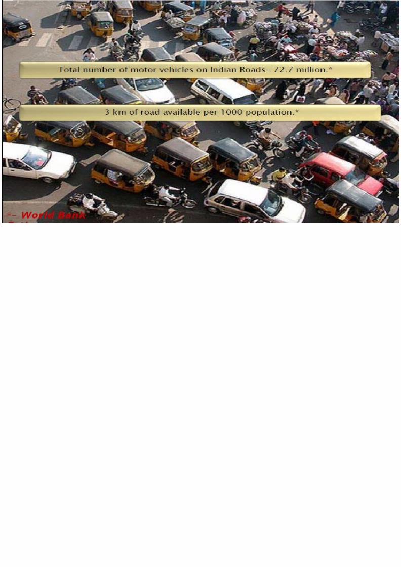
•Traffic management is the planning, monitoring and control or influencing of traffic.
•The Traffic Systems Management Program (TSM) is used to increase the capacity of State and local systems by increasing the number of peak-hour person-trips by improving eisting facilities !ithout m

7/18/2019 Akash Agrawal Ans Ashok Kattimani
http://slidepdf.com/reader/full/akash-agrawal-ans-ashok-kattimani 3/29
Objectives
• #nsure reliable and safe operation of transport.
• #nsure fair allocation of infrastructure space (road space,
slots, etc.) among competing users.
• $mproving the travelling mobility.
• %onserving the energy !hile protecting the environment.
7/18/2019 Akash Agrawal Ans Ashok Kattimani
http://slidepdf.com/reader/full/akash-agrawal-ans-ashok-kattimani 4/29
&eed of Traffic Management

7/18/2019 Akash Agrawal Ans Ashok Kattimani
http://slidepdf.com/reader/full/akash-agrawal-ans-ashok-kattimani 5/29

7/18/2019 Akash Agrawal Ans Ashok Kattimani
http://slidepdf.com/reader/full/akash-agrawal-ans-ashok-kattimani 6/29
Role of GIS in TMS
GIS Plays Significant Role In Each Field Of
Management Some Of These Fields !re "
• Providing 'lternate outes To oad sers.
• Providing &ecessary $nformation To Passengers.
• *or Proper Signal %ontrol.
• Minimi+ing 'ccidents.
• eduction f %ongestion Spots.

7/18/2019 Akash Agrawal Ans Ashok Kattimani
http://slidepdf.com/reader/full/akash-agrawal-ans-ashok-kattimani 7/29
!##I$E%T MI%IMI&!TIO%
• 'ccidents %an e Minimi+e Through $S y eneratin
ase f Most 'ccidents Prone Spots (%rash Spots).
• $nformation %an e Provided #ither $n Tabular r rap
*ormat To The sers.
• /rivers ecome #tra %autious 't Such Spots 0ence *r
%an e Maintained.

7/18/2019 Akash Agrawal Ans Ashok Kattimani
http://slidepdf.com/reader/full/akash-agrawal-ans-ashok-kattimani 8/29
M#T0/12
• 1oad Pedestrian-vehicle %rash /ata 'nd Segregate The /
1ocation
• %ompute ' Severity $nde 't #ach 1ocation.
• #amine The Spatial Patterns f The Pedestrian-vehicle %
• %reate ' Pedestrian-vehicle %rash 0ot Spots Map.• 1oad The us Stop /ata 'nd $dentify us Stops $n 0ot Sp
• %ompute Severity $ndices 'nd ank nsafe us Stops.
7/18/2019 Akash Agrawal Ans Ashok Kattimani
http://slidepdf.com/reader/full/akash-agrawal-ans-ashok-kattimani 9/29LOCATION OF PEDISTRIAL VEHICLE CRASHES

7/18/2019 Akash Agrawal Ans Ashok Kattimani
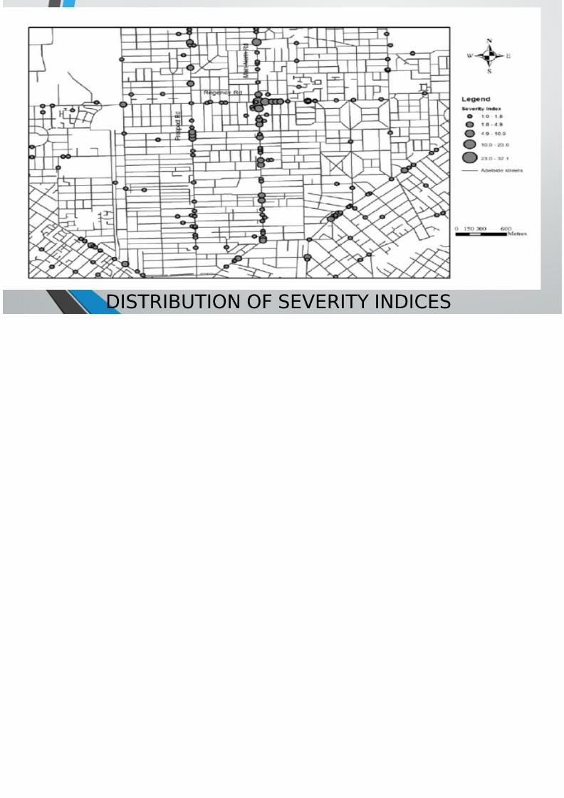
http://slidepdf.com/reader/full/akash-agrawal-ans-ashok-kattimani 10/29DISTRIBUTION OF SEVERITY INDICES

7/18/2019 Akash Agrawal Ans Ashok Kattimani
http://slidepdf.com/reader/full/akash-agrawal-ans-ashok-kattimani 11/29PEDESTRIAN VEHICLE HOT SPO

7/18/2019 Akash Agrawal Ans Ashok Kattimani
http://slidepdf.com/reader/full/akash-agrawal-ans-ashok-kattimani 12/29UNSAFE BUS STOP IN HOT SPOT AR

7/18/2019 Akash Agrawal Ans Ashok Kattimani
http://slidepdf.com/reader/full/akash-agrawal-ans-ashok-kattimani 13/29
P'SS#&# $&*M'T$& S2
• Passenger Information System design for multi'modal transit syst
integrates GIS( %et)or* !nalysis( user interfacing and database m
• PIS gives ans)ers to user +ueries li*e , -ocations and stre
O.timum .ath ba
O.timum .ath on
O.timum .ath ba
Tri. ma*ing infor
Schedule of .ubli
Fare En+uiry
7/18/2019 Akash Agrawal Ans Ashok Kattimani
http://slidepdf.com/reader/full/akash-agrawal-ans-ashok-kattimani 14/29
Three'tier !rchitecture for Passenger Information System

7/18/2019 Akash Agrawal Ans Ashok Kattimani
http://slidepdf.com/reader/full/akash-agrawal-ans-ashok-kattimani 15/29
/0ER1 PRO#E$0RE I% ! PIS
7/18/2019 Akash Agrawal Ans Ashok Kattimani
http://slidepdf.com/reader/full/akash-agrawal-ans-ashok-kattimani 16/29
#!SE ST0$1
' $S 'pproach to $dentify oa
&et!ork $mprovement &eeds By: Chand!a" and W#$%$&$'a
7/18/2019 Akash Agrawal Ans Ashok Kattimani
http://slidepdf.com/reader/full/akash-agrawal-ans-ashok-kattimani 17/29
Study 'rea
3adu!ela re
!hich is loca
!estern prov
1anka

7/18/2019 Akash Agrawal Ans Ashok Kattimani
http://slidepdf.com/reader/full/akash-agrawal-ans-ashok-kattimani 18/29
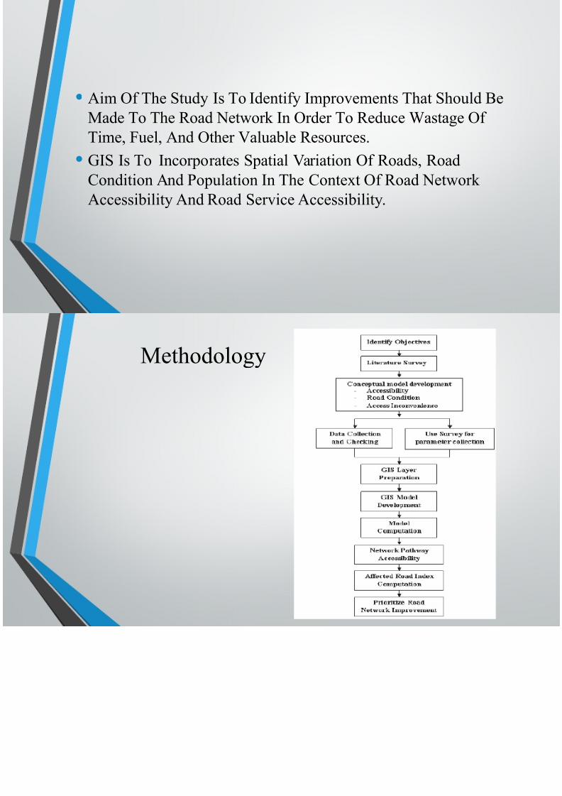
•'im f The Study $s To $dentify $mprovements That ShMade To The oad &et!ork $n rder To educe 4asta
Time, *uel, 'nd ther 5aluable esources.
• $S $s To $ncorporates Spatial 5ariation f oads, oa
%ondition 'nd Population $n The %ontet f oad &et
'ccessibility 'nd oad Service 'ccessibility.

7/18/2019 Akash Agrawal Ans Ashok Kattimani
http://slidepdf.com/reader/full/akash-agrawal-ans-ashok-kattimani 19/29
Methodology
7/18/2019 Akash Agrawal Ans Ashok Kattimani
http://slidepdf.com/reader/full/akash-agrawal-ans-ashok-kattimani 20/29
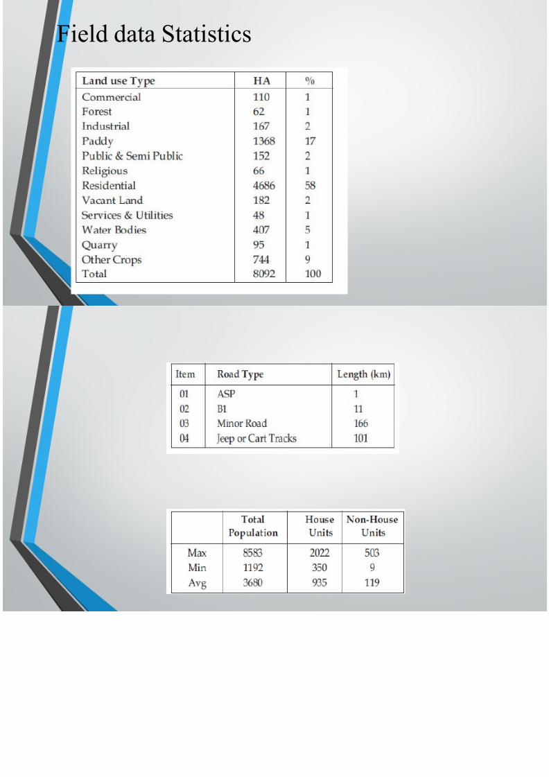
*ield data Statistics

7/18/2019 Akash Agrawal Ans Ashok Kattimani
http://slidepdf.com/reader/full/akash-agrawal-ans-ashok-kattimani 21/29
7/18/2019 Akash Agrawal Ans Ashok Kattimani
http://slidepdf.com/reader/full/akash-agrawal-ans-ashok-kattimani 22/29
Spatial /ata 1ayers sed $n The Study
7/18/2019 Akash Agrawal Ans Ashok Kattimani
http://slidepdf.com/reader/full/akash-agrawal-ans-ashok-kattimani 23/29
oad feeder clusters in the
study area

7/18/2019 Akash Agrawal Ans Ashok Kattimani
http://slidepdf.com/reader/full/akash-agrawal-ans-ashok-kattimani 24/29
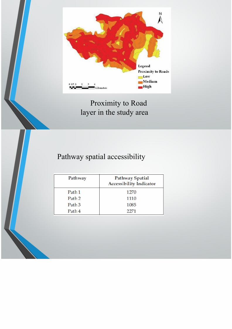
Proimity to oad
layer in the study area

7/18/2019 Akash Agrawal Ans Ashok Kattimani
http://slidepdf.com/reader/full/akash-agrawal-ans-ashok-kattimani 25/29
Path!ay spatial accessibility

7/18/2019 Akash Agrawal Ans Ashok Kattimani
http://slidepdf.com/reader/full/akash-agrawal-ans-ashok-kattimani 26/29
'ffected roadvalues in diff
Spatial accessibility
indicator for pro"ect area

7/18/2019 Akash Agrawal Ans Ashok Kattimani
http://slidepdf.com/reader/full/akash-agrawal-ans-ashok-kattimani 27/29
#O%#-0SIO%
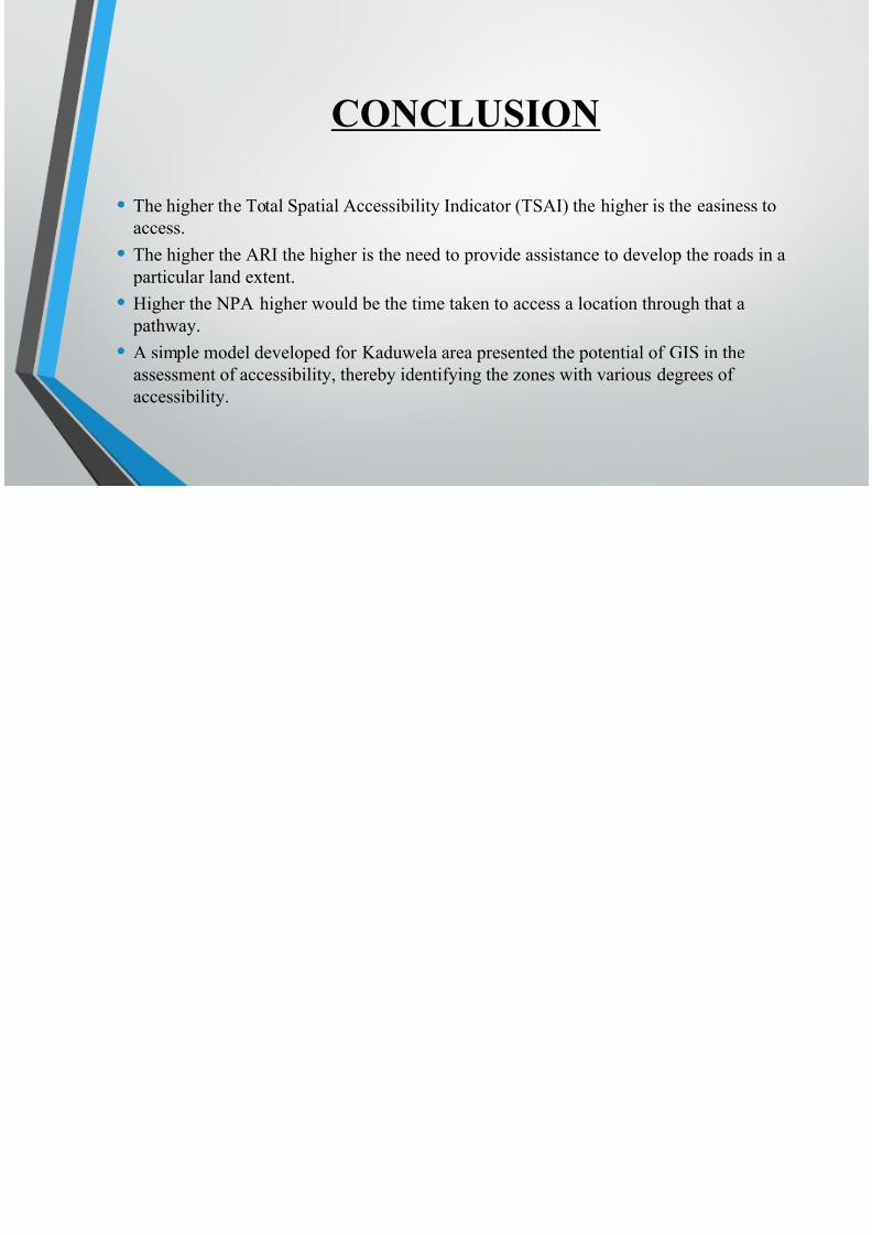
• The higher the Total Spatial 'ccessibility $ndicator (TS'$) the higher is the
access.
• The higher the '$ the higher is the need to provide assistance to develop th
particular land etent.
•0igher the &P' higher !ould be the time taken to access a location through path!ay.
• ' simple model developed for 3adu!ela area presented the potential of $S
assessment of accessibility, thereby identifying the +ones !ith various degre
accessibility.

7/18/2019 Akash Agrawal Ans Ashok Kattimani
http://slidepdf.com/reader/full/akash-agrawal-ans-ashok-kattimani 28/29
#*#&%#S
• ' $S 'pproach To $dentify oad &et!ork $mprovement &eeds 6 %ase Stud
(Sri 1anka) by %handimal 4. P. '. $. M and 4i"esekera &.T.S.
• !!!.trafficinfratech.com
• (an!)y.*ha&'a+a'(y,(*%.*)!
•NPTEL W$+ C)-'%$

7/18/2019 Akash Agrawal Ans Ashok Kattimani
http://slidepdf.com/reader/full/akash-agrawal-ans-ashok-kattimani 29/29
Thank you 4 your attention !