aispace concept implementation communication, navigation ... · international civil aviation...
TRANSCRIPT

International Civil Aviation Organization
AISPACE CONCEPT IMPLEMENTATION Communication, Navigation and
Surveillance Infrastructure
Julio SiuCommunications, Navigation and Surveillance Regional
OfficerICAO NACC Regional Office
ICAO Workshop on PBN Airspace Redesign and GNSS Implementation supporting PBN
27‐30 August, 2012

2
Outline
• Operational references and considerations• Existing Communication Infrastructure / Improvements
• Existing Surveillance Infrastructure / Improvements
• Existing Navigation Infrastructure / Improvements
Operational references and considerations
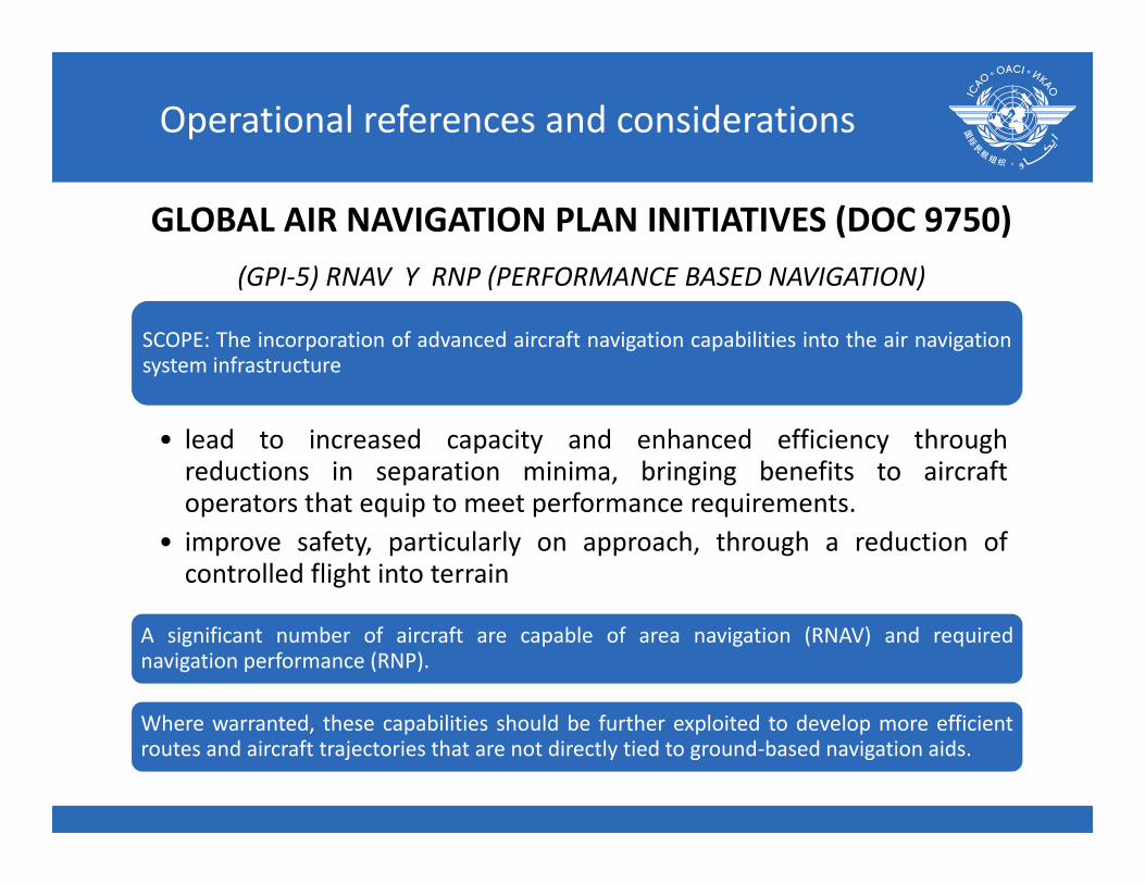
SCOPE: The incorporation of advanced aircraft navigation capabilities into the air navigationsystem infrastructure
• lead to increased capacity and enhanced efficiency throughreductions in separation minima, bringing benefits to aircraftoperators that equip to meet performance requirements.
• improve safety, particularly on approach, through a reduction ofcontrolled flight into terrain
A significant number of aircraft are capable of area navigation (RNAV) and requirednavigation performance (RNP).
Where warranted, these capabilities should be further exploited to develop more efficientroutes and aircraft trajectories that are not directly tied to ground‐based navigation aids.
GLOBAL AIR NAVIGATION PLAN INITIATIVES (DOC 9750)(GPI‐5) RNAV Y RNP (PERFORMANCE BASED NAVIGATION)

Operational references and considerations
SCOPE: The establishment of more flexible and dynamic route systems, on the basis of navigation performance capability, aimed at accommodating preferred flight trajectories.
The implementation of ATS route structures that avoid concentrations of aircraft over congested points and implementation of an ATS routing environment that meets the needs of the airspace users to operate along preferred and dynamic flight trajectories, will increase capacity and increase aircraft operating efficiency.
RNAV routes are not restricted to the location of ground‐based aids and provide benefits to aircraft operators and the ATM system.
All modern aircraft are RNAV capable, and efforts should be made to design and implement RNAV routes.
GLOBAL AIR NAVIGATION PLAN INITIATIVES (DOC 9750)(GPI‐7) DYNAMIC AND FLEXIBLE ATS ROUTE MANAGEMENT

Operational references and considerations
GLOBAL AIR NAVIGATION PLAN INITIATIVES (DOC 9750)(GPI‐11) RNP AND RNAV STANDARD INSTRUMENT DEPARTURES (SIDS)
AND STANDARD TERMINAL ARRIVALS (STARS)
Scope: The optimization of the terminal control area (TMA)through implementation of improved ATS route structures basedon RNP and RNAV, connecting the en‐route phase of flight withthe final approach, based on improved coordination processes.
The implementation of optimized standard instrumentDepartures (SIDs), standard instrument arrivals (STARs),instrument flight procedures, and holding, approach andassociated procedures.

Operational references and considerations
GLOBAL AIR NAVIGATION PLAN INITIATIVES (DOC 9750)(GPI‐21) NAVIGATION SYSTEMS
Scope: Enable the introduction and evolution of PBN supported by a robust navigation infrastructureproviding an accurate, reliable and seamless global positioning capability.
the progressive introduction of PBN must be supported by an appropriate navigation infrastructureconsisting of an appropriate combination of global navigation satellite systems (GNSS), self‐containednavigation systems (inertial navigation system) and conventional ground‐based navigation aids.
Near‐term applications of GNSS are intended to enable the early introduction of satellite‐based areanavigation without any infrastructure investment, using the core satellite constellations and integratedmultisensor airborne systems.Medium/longer‐term applications will make use of existing and future satellite navigation systems withsome type of augmentation or combination of augmentations required for operation in a particular phaseof flight.

AIR SPACE CONCEPT
NavigationApplication
NavigationSpecification
NAVAID Infrastructure
Operational references and considerations

NAV specificationsNAV specifications
RNAV SpecificationsRNAV Specifications
RNAV 10oceanic and Remote
continental
RNAV 10oceanic and Remote
continental
RNAV 5RNAV 2RNAV 1
Enroute and terminal
RNAV 5RNAV 2RNAV 1
Enroute and terminal
RNP SpecificationsRNP Specifications
RNP 4RNP2
Oceanic and Remotecontinental
RNP 4RNP2
Oceanic and Remotecontinental
RNP 2RNP 1
RNP APCHRNP AR APCH
RNP 0.3Enroute and terminal
RNP 2RNP 1
RNP APCHRNP AR APCH
RNP 0.3Enroute and terminal
RNP with additionalrequirements to be determined (ex. 3D,
4D)
RNP with additionalrequirements to be determined (ex. 3D,
4D)
Operational references and considerations

Navigation Specification and CNS Infrastructure NAV specification Communication and Surveillance Navigation
RNAV 10 (RNP 10) Determined in the implementation process in accordance to local and regional characteristics
No ground‐based Navaids required
RNAV 5 (B RNAV) Direct pilot to ATC Communications Radar monitoring by ATS
VOR/DME DME/DME INS/IRS GNSS
RNAV 2/ RNAV 1 Direct pilot to ATC Communications Radar surveillance by ATS
GNSS DME/DME DME/DME/IRU DME/VOR
RNP 4 Determined in the implementation process in accordance to local and regional characteristics (CPDLC, ADS‐C, …)
GNSS
RNP 2 Determined based on operational considerations (route spacing, traffic density, etc.)
GNSS
RNP 1 (Basic) Direct pilot to ATC Communications GNSS
RNP APCH No specific requirements. Obstacle clearance required
GNSS down to LNAV or LNAV/VNAV minima (SBAS, etc.)
MIssed approach segment (conventional navaids)
RNP AR APCH No specific requirements. GNSSDME/DME as alternative
RNP 0.3 No specific requirements. GNSS
Operational references and considerations

10
PBN IMPLEMENTATION PROCESS
PROCESS 1: IDENTIFYING AN ICAO NAVIGATION SPECIFICATION FOR IMPLEMENTATION
Step 6 — CNS/ATM Assumptions (allowing for identification of potential navigation specification)
• The (new) airspace concept to be designed is based upon certainATM/CNS assumptions. Assumptions cover a wide field and need to takeaccount of the expected environment applicable for the time when thenew airspace operation is intended to be implemented (e.g. in 20XX).
• the ATS Surveillance and Communication to be used in 20XX.• identify what CNS/ATM components are already ‘available’ and what will
be available when the when the implementation occurs.
Packaging Tomorrow’s Aviation System
Operational references and considerations

11
Operational references and Considerations
Sources: Ascend Worldwide, Official Airlines Guide (OAG) – Scheduled Commercial Traffic. Preliminary Data.
0
2,000,000
4,000,000
6,000,000
8,000,000
10,000,000
12,000,000
14,000,000
2007 2008 2009 2010 2011
Dep
artures
Africa AsiaEurope Latin America and the CaribbeanNorthern America Oceania
Latin Americaand the Caribbean
GlobalTraffic by UN Region (2007‐2011)

12
Operational references and Considerations
Accidents & Related Fatalities by Occurrence CategoriesScheduled Commercial Traffic – MTOW > 2 250 kg (Yrs 2006‐ 2010 )
Runway Safety Related
Loss of Control Inflight
Controlled Flight into Terrain
ICAO SAFETY PRIORITIES

13
Operational references and Considerations
Latin America and the Caribbean is a medium traffic region – 4th highest in the world
For CFIT: focus is now on implementation ofPerformance‐based Navigation (PBN)
• Objective is the provision of approach with vertical guidance at every instrument runway of every airport
Outstanding Operational Issues

Existing Communication Infrastructure/ Improvements
VHF AMS Radio coverage

Existing Communication Infrastructure/ Improvements
AMS CommunicationsImprovements
Achieved and ongoing
• NorthWestern Curacao FIR Communication: longrange radio systems
• SouthWestern Kingston FIR communications:radio repeater at Puerto Cabezas, Nicaragua
• Southern Mexico FIR communication – nearAcapulco: repeaters being implemented
• Pacific Oceanic Central American FIR:CPLDC/ADS‐C
• Port‐au‐ Prince FIR Telecommunication recoveryplan: ongoing
• PIARCO FIR new telecommunicationsimprovement plan: ongoing

Existing Communication Infrastructure / Improvements

Existing Communication Infrastructure/ Improvements
Regional Networks improvements
•ECAR AFS Network modernization: 2011•Central American Network beingsupported with new terrestrial Network•AMHS implementation•MEVA Network modernization: MEVA IIIProcess•CPDLC/ ADS‐C implementation•South American Nodes in CAR to bemodernized within REDDIG II frameware

Existing Surveillance Infrastructure / Improvements

Existing Surveillance Infrastructure / Improvements
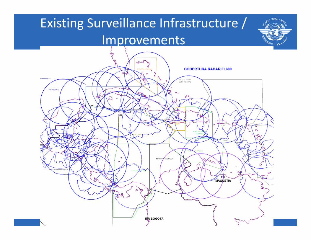
Existing Surveillance Infrastructure / Improvements
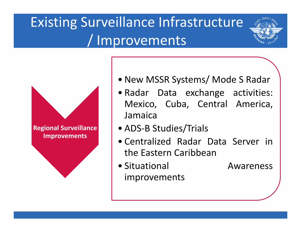
Regional SurveillanceImprovements
•New MSSR Systems/ Mode S Radar• Radar Data exchange activities:Mexico, Cuba, Central America,Jamaica
• ADS‐B Studies/Trials• Centralized Radar Data Server inthe Eastern Caribbean
• Situational Awarenessimprovements
Existing Surveillance Infrastructure/ Improvements

Existing Navigation Infrastructure / Improvements

Existing Navigation Infrastructure / Improvements

Existing Navigation Infrastructure / Improvements

Existing Navigation Infrastructure / Improvements

NavigationImprovements and Relevant events
• Navaidsreplacement/modernization
• GBAS studies• SBAS Study by SACCSA Project
Existing Navigation Infrastructure / Improvements

Conclusionsa) The CAR Region has a well‐developed telecommunication
infrastructure (regional networks) that satisfies all AirNavigation Plan requeriments and is being upgraded tofacilitate the implementation of new operationalrequirements including the performance basednavigation
b) AMS VHF communication services in the CAR regioncover great part of the CAR Airspace Service volume,with several improvements in its voice quality andcoverage.
c) Surveillance services in the CAR region had beenimproving significantly under a collaborative basis withthe exchange of radar data.
d) ADS‐B data activities are ongoing with data collectionand trials

Conclusions
• Even though VOR/DME coverage in the CARRegion has improved significally, several areasneed to improve the quality and coverage ofnavaids services.
• Very few activities/evaluations in the CARRegions for Aumentation systemimplementations (GBAS, SBAS)
• Need for navigation infrastructure analysis(DME/DME coverage, VOR, etc.) based on CARairspace concept redesign/ update.

29
Questions?
Packaging Tomorrow’s Aviation System

30