airport development - open_jicareport.jica.go.jpopen_jicareport.jica.go.jp/pdf/12018842_14.pdf ·...
TRANSCRIPT

The JICA Study on Formulation of Spatial Planning for GERBANGKERTOSUSILA Zone
Final Report Volume 4: Development Action Plan for Transportation Sector
12-1
12. AIRPORT DEVELOPMENT
12.1 Air Transport Demand
Juanda International Airport, located in Kabupaten Sidoarjo, in the southern part of Surabaya,
is the major international airport in East Java. Only 20km from the city, Juanda
International Airport renewed operations on 15 November 2006, through financial assistance
from the Japanese government. The passenger terminal was relocated from the south side
of the runway to the north side, not only to increase passenger capacity but also to separate
the passenger terminal from the mix-use base terminal of the Indonesian Navy. It has a
total area of 4,773 hectares and is 2.74 meters above sea level. The airport has a single
3,000m runway which can receive a B747 class aircraft. Its passenger terminal has a total
area of 30,100 square meters and has a service capacity for six million passengers and
45,000 tons of cargo freight per year. The airport currently serves 11 domestic airways and
seven international airways, accounting for 1,620 domestic flights and 190 international
flights per week. The airport currently has flights to 15 cities and seven countries.
The annual air passenger trend at Juanda Airport is shown in Figure 12.1.1. As the graph
implies future passenger trend will increase like those in the last couple of years. Designed
in 1994, the terminal was meant to handle six million passengers per year (i.e. five million
domestic passengers and one million international passengers per year). However, after just
a year of operating, passenger demand immediately jumped to seven million. Its number of
passengers reached nine million in 2008. In mid 2010 total passengers already reached 11
million for domestic and international flights. About 13 million passengers were expected by
the end of 2010.
0.0
1.0
2.0
3.0
4.0
5.0
6.0
7.0
8.0
9.0
10.0
11.0
19
95
19
96
19
97
19
98
19
99
20
00
20
01
20
02
20
03
20
04
20
05
20
06
20
07
20
08
20
09
Millio
n p
ass
en
gers
per
yea
r
Domestic
International
Total
Source: Angkasa Pura I
Figure 12.1.1 Trend of Annual Air Passengers at Juanda Airport

The JICA Study on Formulation of Spatial Planning for GERBANGKERTOSUSILA Zone
Final Report Volume 4: Development Action Plan for Transportation Sector
12-2
Passenger demand per year is now twice larger than the capacity of the terminal due to the
increase of Low Cost Carriers (LCCs). During peak hours of the regular season, flight
frequency is 25 flights per hour, which makes Juanda a high-risk airport due to its close
flight intervals that could lead to accidents.
Thus, Juanda Airport cannot accommodate further passenger demands, and since its apron is
commonly in full use by aircrafts, aviation companies have been forced to shift to larger
aircrafts (e.g Airbus planes) in order to accommodate as many passengers as possible.
Operating hours also often extend up to midnight. Transportation links has also become
an issue, especially in how to connect the ever increasing number of passenger to other areas
in Surabaya through other transportation modes. As mentioned earlier, one solution to this
problem is the development of the Waru-Juanda Railway Link (W2), or the Juanda
Airport-Sidotopo BRT line (B2).
A Civil Aviation policies give airport operators the right to conduct the necessary
developmental actions if the general usage of the airport facility (e.g. apron, runway,
terminal building, parking lot, etc) has reached 80% of their capacity. In Juanda’s case
capacity has already reached 95% and significant expansion project has yet to be conducted,
which necessitates implementing such a project as soon as possible.
12.2 Airport Development Master Plan
Transportation Ministerial Decree No. 20, 2002 is the master plan for the development of
Juanda Airport (Figure 12.2.1). The master plan consists of several development phases.
Stage I of Phase I (i.e. the area colored in purple) was implemented and completed through
financial assistance from Japan. Stage II of Phase I (i.e. the area colored in light purple) is
currently under way.
The additional runway extension of about 500 meters and the terminal building expansion,
which were mandated by the said decree, are the first priorities. Due to the policy of
“lesser interference” from donor countries, Angkasa Pura I, the airport operator, will have to
conduct terminal development by itself, while the central government (i.e., Ministry of
Transport) will be responsible for the runway extension. Starting with a detailed design for
a new terminal (eastward of the existing terminal), Angkasa Pura I’s target expectation is to
realize all development plans by using its own budget.
On the other hand, Angkasa Pura I also has a plan to extend the terminal building northward
to accommodate 30 million passengers per year in the next 15-20 years. However, this plan
does not consider arrangement of the terminal station of the above-mentioned Waru - Juanda
Railway Link (W2), which is to be located in the same premises.

The JICA Study on Formulation of Spatial Planning for GERBANGKERTOSUSILA Zone
Final Report Volume 4: Development Action Plan for Transportation Sector
12-3
Source: Transportation Ministerial Decree number 20 year 2002
Figure 12.2.1 Juanda Airport Master Plan
Aside from the increasing air transport demand, in the ”Master Plan Study on the Strategic
Policy of the Air Transport Sector in the Republic of Indonesia” (JICA, 2004), air passenger
volume and aircraft movements are forecasted and shown in Table 12.2.1 and Table 12.2.2.
This Study has concluded that the above-mentioned master plan for Juanda Airport is
adequate in principle. Furthermore, the study also has proposed that Angkasa Pura I
should examine the feasibility of land acquisition for the second runway that would be
required after 2025. While the forecasts have underestimations, the Study also suggests
that such development in the master plan should be implemented with adjustments in the
facility requirements.
Table 12.2.1 Passenger Volume Forecast (Unit: million/year)
Year 2009 2015 2025
Domestic 6.96 9.25 13.99
International 0.92 1.32 2.39
Total 7.89 10.57 16.38
Source : “The Master Plan Study on the Strategic Policy of the Air Transport Sector in the Republic of Indonesia” (JICA, 2004)
Table 12.2.2 Aircraft Movements Forecast
(Unit: 1,000/year)
Year 2009 2015 2025
Domestic 97.6 87.6 138.9
International 9.5 13.8 18.9
Total 107.0 101.3 157.7
Source : “The Master Plan Study on the Strategic Policy of the Air Transport Sector in the Republic of Indonesia” (JICA, 2004)
The JICA Study on Formulation of Spatial Planning for GERBANGKERTOSUSILA Zone
Final Report Volume 4: Development Action Plan for Transportation Sector
12-4
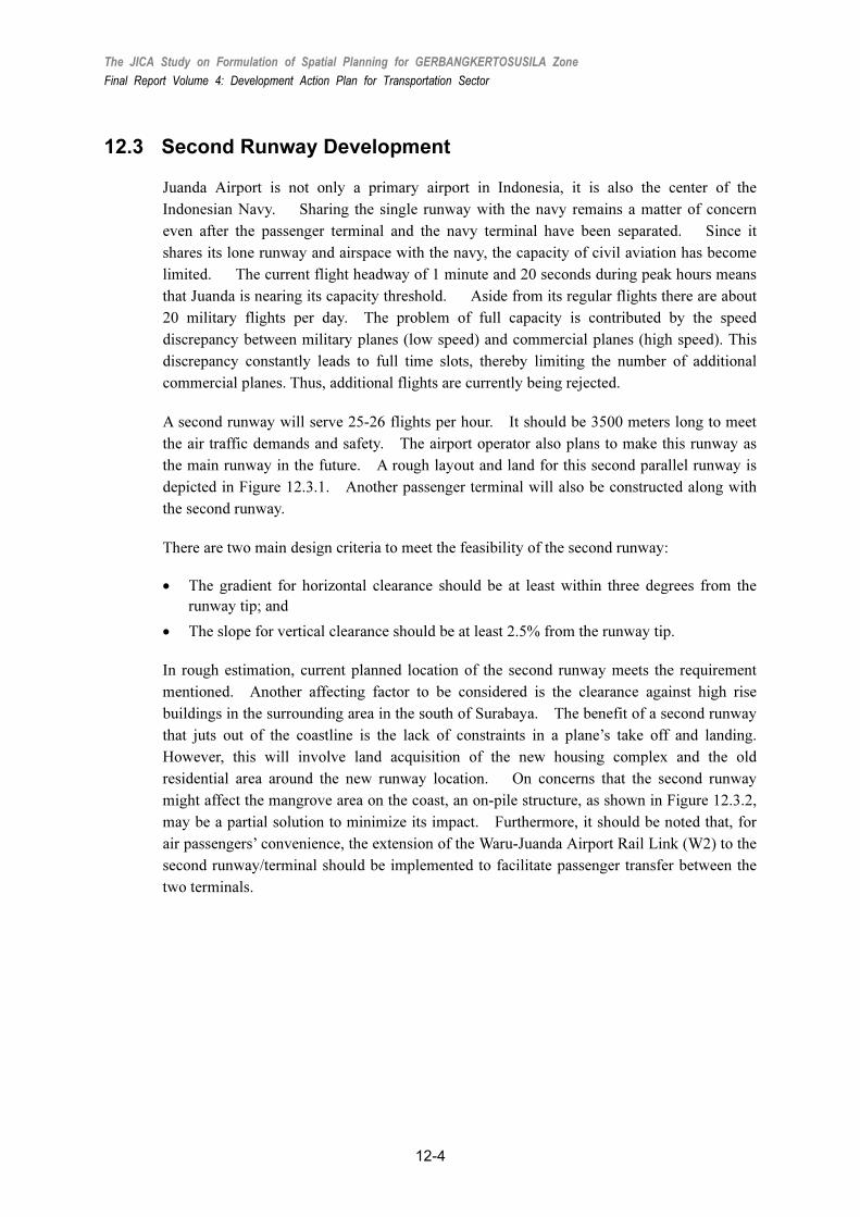
12.3 Second Runway Development
Juanda Airport is not only a primary airport in Indonesia, it is also the center of the
Indonesian Navy. Sharing the single runway with the navy remains a matter of concern
even after the passenger terminal and the navy terminal have been separated. Since it
shares its lone runway and airspace with the navy, the capacity of civil aviation has become
limited. The current flight headway of 1 minute and 20 seconds during peak hours means
that Juanda is nearing its capacity threshold. Aside from its regular flights there are about
20 military flights per day. The problem of full capacity is contributed by the speed
discrepancy between military planes (low speed) and commercial planes (high speed). This
discrepancy constantly leads to full time slots, thereby limiting the number of additional
commercial planes. Thus, additional flights are currently being rejected.
A second runway will serve 25-26 flights per hour. It should be 3500 meters long to meet
the air traffic demands and safety. The airport operator also plans to make this runway as
the main runway in the future. A rough layout and land for this second parallel runway is
depicted in Figure 12.3.1. Another passenger terminal will also be constructed along with
the second runway.
There are two main design criteria to meet the feasibility of the second runway:
• The gradient for horizontal clearance should be at least within three degrees from the
runway tip; and
• The slope for vertical clearance should be at least 2.5% from the runway tip.
In rough estimation, current planned location of the second runway meets the requirement
mentioned. Another affecting factor to be considered is the clearance against high rise
buildings in the surrounding area in the south of Surabaya. The benefit of a second runway
that juts out of the coastline is the lack of constraints in a plane’s take off and landing.
However, this will involve land acquisition of the new housing complex and the old
residential area around the new runway location. On concerns that the second runway
might affect the mangrove area on the coast, an on-pile structure, as shown in Figure 12.3.2,
may be a partial solution to minimize its impact. Furthermore, it should be noted that, for
air passengers’ convenience, the extension of the Waru-Juanda Airport Rail Link (W2) to the
second runway/terminal should be implemented to facilitate passenger transfer between the
two terminals.

The JICA Study on Formulation of Spatial Planning for GERBANGKERTOSUSILA Zone
Final Report Volume 4: Development Action Plan for Transportation Sector
12-5
Source: JICA Study Team
Figure 12.3.1 Rough Layout and Land of the Parallel Second Runway
Source: Nippon Steel Corporation
Figure 12.3.2 Example of an On-Pile Structure of Tokyo’s Haneda Airport
12.4 Second Airport Development
While the construction of an additional runway and terminal facilities is a partial solution, a
feasibility study has yet to be conducted on them. The development of a new airport has
also been considered with several alternative locations, as shown in Figure 12.4.1. If a new
airport will be constructed in Kabupaten Bangkalan or Kabupaten Lamongan, their airspace
may still overlap with Juanda Airport. In terms of a plane’s rotating radius, Kecamatan
Ujung Pangkah, in Kabupaten Gresik may be the best alternative. Meanwhile, if it is
located in Kabupaten Lamongan, it will serve not only GKS but also the Tuban and

The JICA Study on Formulation of Spatial Planning for GERBANGKERTOSUSILA Zone
Final Report Volume 4: Development Action Plan for Transportation Sector
12-6
Bojonegoro areas. Even if all the candidate locations are close to arterial and toll roads in
the road transport development plan, construction of a proper access road will still be
required including the toll road option when the location of a new airport, which will need at
least 3,000 hectares of available space, has been determined.
Source: Transportation Agency (Dinas Perhubungan) of East Java Province
Figure 12.4.1 Alternative Second Airport Locations and Related Road Development
While the central government has been apprised of the second runway and second airport
development plans for Surabaya, a feasibility study is necessary to give priorities to those
plans in order to deal with the ever increasing air transportation demand. After several
alternatives on basic design, they need to be compared and evaluated not only from an
economic or financial perspective but also from various essential aspects, including
accessibility by land transport and environmental evaluation. For this, it is needless to say
that data collection regarding present conditions will be essential, and this includes not only
field surveys but also origin-destination (OD) and opinion surveys, which should be
conducted as soon as possible. The results of these surveys should be discussed among the
related agencies and the central, provincial, and local governments, as well as the airport
operator.
FREIGHT TRANSPORTATION SYSTEM
The JICA Study on Formulation of Spatial Planning for GERBANGKERTOSUSILA Zone
Final Report Volume 4: Development Action Plan for Transportation Sector
13-1
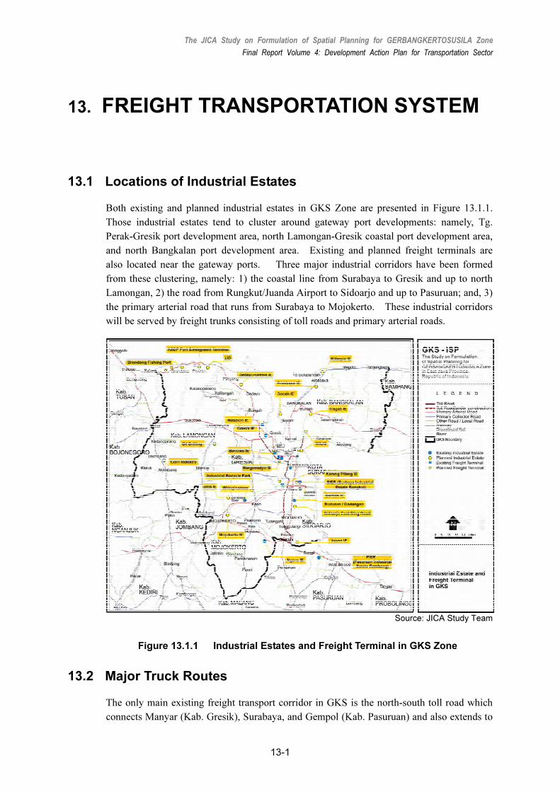
13. FREIGHT TRANSPORTATION SYSTEM
13.1 Locations of Industrial Estates
Both existing and planned industrial estates in GKS Zone are presented in Figure 13.1.1.
Those industrial estates tend to cluster around gateway port developments: namely, Tg.
Perak-Gresik port development area, north Lamongan-Gresik coastal port development area,
and north Bangkalan port development area. Existing and planned freight terminals are
also located near the gateway ports. Three major industrial corridors have been formed
from these clustering, namely: 1) the coastal line from Surabaya to Gresik and up to north
Lamongan, 2) the road from Rungkut/Juanda Airport to Sidoarjo and up to Pasuruan; and, 3)
the primary arterial road that runs from Surabaya to Mojokerto. These industrial corridors
will be served by freight trunks consisting of toll roads and primary arterial roads.
Source: JICA Study Team
Figure 13.1.1 Industrial Estates and Freight Terminal in GKS Zone
13.2 Major Truck Routes
The only main existing freight transport corridor in GKS is the north-south toll road which
connects Manyar (Kab. Gresik), Surabaya, and Gempol (Kab. Pasuruan) and also extends to

The JICA Study on Formulation of Spatial Planning for GERBANGKERTOSUSILA Zone
Final Report Volume 4: Development Action Plan for Transportation Sector
13-2
Tg. Perak Port. Since the section near the center of Surabaya, namely the Dupak–Waru toll
road, which runs along the west periphery of CBD of Surabaya, this toll road is also used by
many commuting vehicles.
In fact, all the existing toll road sections in GKS have dual four-lane carriageways, except
for sections of the Dupak–Waru, which has six lanes serving as a trunk freight transport
corridor. As the table below shows, the composition of trucks is very high on the toll roads,
especially on sections near Tg. Perak Port. This significantly impacts the traffic flow, as large
slow moving vehicles take up considerable space on the toll roads.
Table 13.2.1 Vehicle Compositions at Major Toll Road Sections (Unit: vehicles/day)
Truck Bus
Location Passenger
Car Pick Up 2-Axle Truck
3-Axle Truck
4 or more Axle Truck
Small Bus
Medium /Large Bus
Total
Dupak-Tg.
Perak
(near Tg.
Perak, TCS01)
10,959
(33%)
3,257 (10%)
6,962 (21%)
4,404 (13%)
6,740
(21%)
39 (0.1%)
473
(1%)
32,834
(100%)
Dupak-Gresik
(near Dupak
Jct., TCS14)
25,161
(45%)
8,706 (16%)
8,498 (15%)
5,045 (9%)
5,914
(11%)
1,655 (2.9%)
1,166
(2%)
56,145 (100%)
Dupak-Gempol
(near
Gedangan,
TC10)
34,540
(55%)
4,950 (8%)
12,048 (19%)
4,001 (6%)
4,500
(7%)
76
(0.1%)
2,690
(4%)
62,805 (100%)
Source: 2009 Traffic Survey, JICA Study Team Note: Number of passengers was estimated based on the result of roadside occupancy observation.
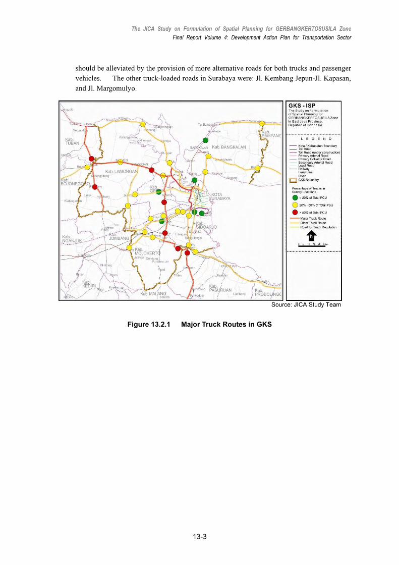
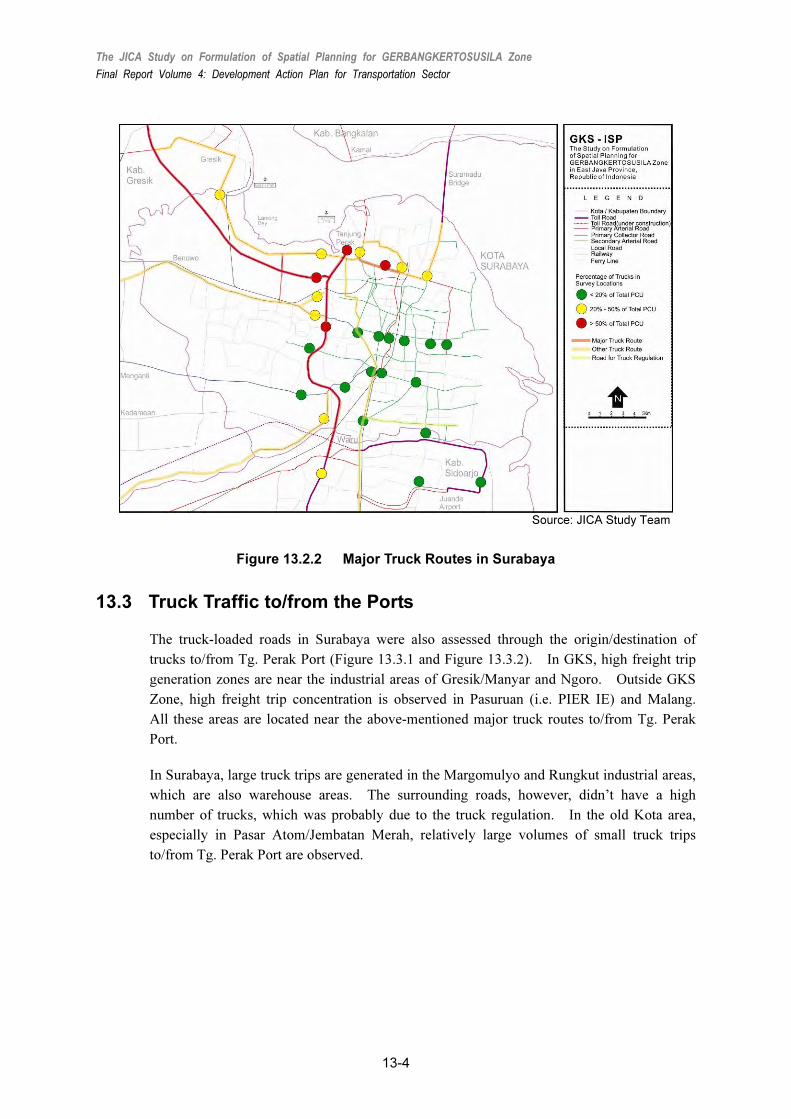
Based on the traffic count survey, which was conducted at more than 60 locations in
Surabaya and GKS, vehicle composition was calculated at each location, and roads that were
loaded with trucks are presented in Figure 13.2.1, for GKS, and Figure 13.2.2, for Surabaya.
In GKS, current truck-loaded roads partially match with the road development corridor.
The major truck routes are: Surabaya–Gresik (Corridor No. 1), Surabaya–Lamongan–Babat
(Corridor No. 2), Tuban–Babat–Jombang (Corridor No. 11),
Gresik–Krian–Mojosari–Gempol (Corridor No. 9), and Gempol–Malang (Corridor No. 5).
On the other hand, truck compositions on other routes such as Surabaya–Sidoarjo (except for
Dupak–Waru), Gresik–Paciran–Tuban, and Surabaya–Bangkalan are still high, but the
percentages are relatively minor.
In Surabaya, trucks transporting between the port and the industrial areas in south Surabaya
or Sidoarjo, have no alternative routes except to go through the CBD where they are banned
during peak hours, as shown in Figure 13.2.2. While this regulation has minimized the
number of trucks from this road, it has also increased the volume on the existing toll roads
and has resulted in the mixture of slow and fast traffic, as explained earlier. Such a burden
on the existing toll roads (i.e. Waru–Dupak–Perak toll road, and Gresik–Dupak toll road)
The JICA Study on Formulation of Spatial Planning for GERBANGKERTOSUSILA Zone
Final Report Volume 4: Development Action Plan for Transportation Sector
13-3
should be alleviated by the provision of more alternative roads for both trucks and passenger
vehicles. The other truck-loaded roads in Surabaya were: Jl. Kembang Jepun-Jl. Kapasan,
and Jl. Margomulyo.
Source: JICA Study Team
Figure 13.2.1 Major Truck Routes in GKS
The JICA Study on Formulation of Spatial Planning for GERBANGKERTOSUSILA Zone
Final Report Volume 4: Development Action Plan for Transportation Sector
13-4
Source: JICA Study Team
Figure 13.2.2 Major Truck Routes in Surabaya
13.3 Truck Traffic to/from the Ports
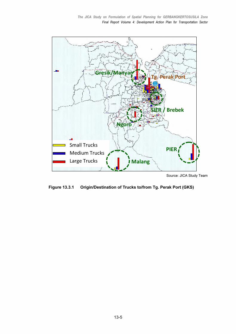
The truck-loaded roads in Surabaya were also assessed through the origin/destination of
trucks to/from Tg. Perak Port (Figure 13.3.1 and Figure 13.3.2). In GKS, high freight trip
generation zones are near the industrial areas of Gresik/Manyar and Ngoro. Outside GKS
Zone, high freight trip concentration is observed in Pasuruan (i.e. PIER IE) and Malang.
All these areas are located near the above-mentioned major truck routes to/from Tg. Perak
Port.
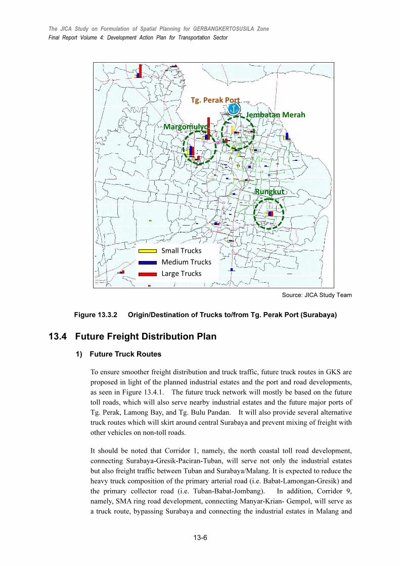
In Surabaya, large truck trips are generated in the Margomulyo and Rungkut industrial areas,
which are also warehouse areas. The surrounding roads, however, didn’t have a high
number of trucks, which was probably due to the truck regulation. In the old Kota area,
especially in Pasar Atom/Jembatan Merah, relatively large volumes of small truck trips
to/from Tg. Perak Port are observed.
The JICA Study on Formulation of Spatial Planning for GERBANGKERTOSUSILA Zone
Final Report Volume 4: Development Action Plan for Transportation Sector
13-5
Gresik/Manyar
Ngoro
Malang
SIER / Brebek
PIERSmall Trucks
Medium Trucks
Large Trucks
Tg. Perak Port
Source: JICA Study Team
Figure 13.3.1 Origin/Destination of Trucks to/from Tg. Perak Port (GKS)
The JICA Study on Formulation of Spatial Planning for GERBANGKERTOSUSILA Zone
Final Report Volume 4: Development Action Plan for Transportation Sector
13-6
Margomulyo
Rungkut
Small Trucks
Medium Trucks
Large Trucks
Tg. Perak Port
Jembatan Merah
Source: JICA Study Team
Figure 13.3.2 Origin/Destination of Trucks to/from Tg. Perak Port (Surabaya)
13.4 Future Freight Distribution Plan
1) Future Truck Routes
To ensure smoother freight distribution and truck traffic, future truck routes in GKS are
proposed in light of the planned industrial estates and the port and road developments,
as seen in Figure 13.4.1. The future truck network will mostly be based on the future
toll roads, which will also serve nearby industrial estates and the future major ports of
Tg. Perak, Lamong Bay, and Tg. Bulu Pandan. It will also provide several alternative
truck routes which will skirt around central Surabaya and prevent mixing of freight with
other vehicles on non-toll roads.
It should be noted that Corridor 1, namely, the north coastal toll road development,
connecting Surabaya-Gresik-Paciran-Tuban, will serve not only the industrial estates
but also freight traffic between Tuban and Surabaya/Malang. It is expected to reduce the
heavy truck composition of the primary arterial road (i.e. Babat-Lamongan-Gresik) and
the primary collector road (i.e. Tuban-Babat-Jombang). In addition, Corridor 9,
namely, SMA ring road development, connecting Manyar-Krian- Gempol, will serve as
a truck route, bypassing Surabaya and connecting the industrial estates in Malang and

The JICA Study on Formulation of Spatial Planning for GERBANGKERTOSUSILA Zone
Final Report Volume 4: Development Action Plan for Transportation Sector
13-7
Pasuruan with the Java north trunk road. Since this toll road will be developed in the
long term the primary arterial road will serve this corridor in the meantime. Similarly,
Corridor 8, which is expected to divert freight traffic from the Dupak-Waru toll road,
will be served by primary arterial road (i.e., Outer East Ring Road) in the short term
and then by the toll road (i.e., Surabaya East Ring Road) in the medium term.
Source: JICA Study Team
Figure 13.4.1 Future Truck Routes in GKS Zone
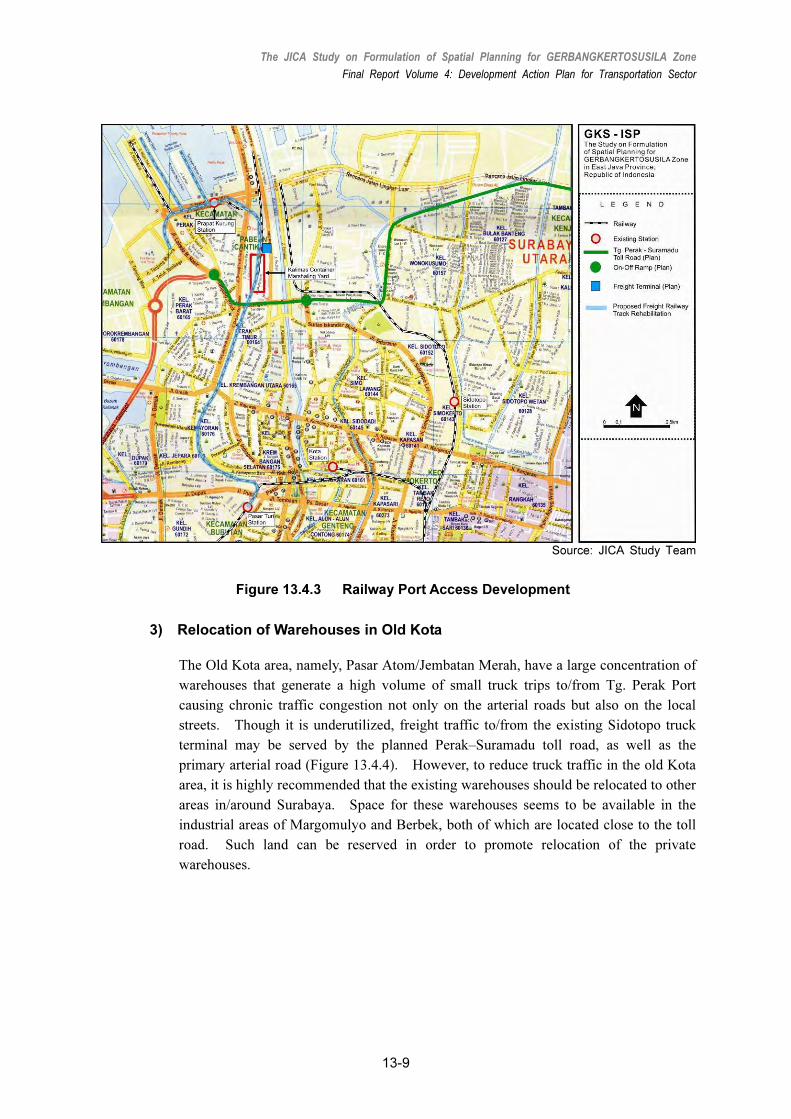
2) Railway Freight Routes
For efficient railway freight, the existing railway freight terminals in Surabaya, namely,
Kalimas, Pasar Turi, and Waru (Figure 13.4.2), should be integrated into a single station,
which is Kalimas. One of the two current container operators has moved from Pasar
Turi to Kalimas. Furthermore, Kalimas station should be reformed as a container
marshaling yard and station, since it has enough land space for a new railway
marshaling yard. Figure 13.4.3 shows the location of Kalimas station and its area
surrounded by Jl. Tanjung Perak Timur, Jl. Kalimas Baru, and north of Jl.
Sisingmangaraja.
In addition, PT. KA plans to revitalize the operation of freight trains to deal with the
container traffic in Tg. Perak Port, i.e., the berths of Nilam, Berlian and TPS (Terminal
Petikemas Surabaya or Surabaya Container Terminal). Hence, the existing dedicated
single-track freight railway track (port access), that connects Pasar Turi and Kalimas

The JICA Study on Formulation of Spatial Planning for GERBANGKERTOSUSILA Zone
Final Report Volume 4: Development Action Plan for Transportation Sector
13-8
station, up to Tg. Perak Port, should be rehabilitated for faster, smoother, and more
reliable freight train services. A study of an elevated single track may also be needed
except for the marshaling yard area.
Kalimas station also needs to be equipped with freight handling facilities. All
containers designated to be transported by railway should be brought to this area by
shanty locomotive and then arranged for long-haul trips using container handling
equipment such as stacker, or RTG. This space should be enough to arrange several
trains with 20 – 30 freight wagons designed to carry 40ft containers. Likewise, the
facilities of Prapat Kurung station to Port Section (From Kalimas) needs revitalization
because it is old and unutilized.
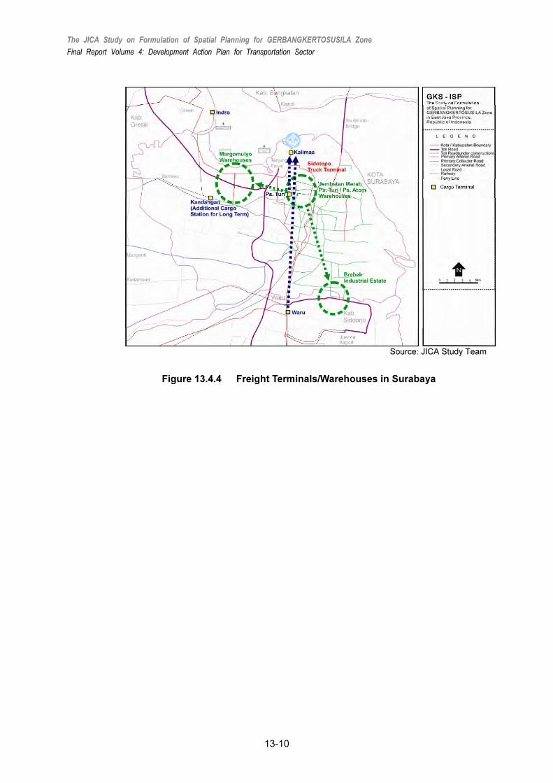
Furthermore, in future, if Kalimas freight station reaches its full capacity for handling
containers, Kandangan station, which is located close to the Margomulyo industrial area,
will need to be developed into another freight terminal in the long term (Figure 13.4.4).
Source: Transportation Agency (Dinas Perhubungan) of East Java Province
Figure 13.4.2 Railway Freight Terminals
The JICA Study on Formulation of Spatial Planning for GERBANGKERTOSUSILA Zone
Final Report Volume 4: Development Action Plan for Transportation Sector
13-9
Source: JICA Study Team
Figure 13.4.3 Railway Port Access Development
3) Relocation of Warehouses in Old Kota
The Old Kota area, namely, Pasar Atom/Jembatan Merah, have a large concentration of
warehouses that generate a high volume of small truck trips to/from Tg. Perak Port
causing chronic traffic congestion not only on the arterial roads but also on the local
streets. Though it is underutilized, freight traffic to/from the existing Sidotopo truck
terminal may be served by the planned Perak–Suramadu toll road, as well as the
primary arterial road (Figure 13.4.4). However, to reduce truck traffic in the old Kota
area, it is highly recommended that the existing warehouses should be relocated to other
areas in/around Surabaya. Space for these warehouses seems to be available in the
industrial areas of Margomulyo and Berbek, both of which are located close to the toll
road. Such land can be reserved in order to promote relocation of the private
warehouses.
The JICA Study on Formulation of Spatial Planning for GERBANGKERTOSUSILA Zone
Final Report Volume 4: Development Action Plan for Transportation Sector
13-10
Source: JICA Study Team
Figure 13.4.4 Freight Terminals/Warehouses in Surabaya
ECONOMIC EVALUATION
The JICA Study on Formulation of Spatial Planning for GERBANGKERTOSUSILA Zone
Final Report Volume 4: Development Action Plan for Transportation Sector
14-1
14. ECONOMIC EVALUATION
14.1 Overview
This section evaluates the economic feasibility of GKS-ISP transportation project based on
the project implementation plan. Economic evaluation examines the economic feasibility
of a project through a cost-benefit analysis from a national economic perspective where
quantified benefits of the project are compared with its economic costs.
The results of the evaluation showed that the Benefit-Cost ratio (B/C) and the Economic
Internal Rate of Return (EIRR) of the project is economically justified from a national
economic viewpoint.
14.2 Comparison of Benefits and Costs
1) “With Project” and “Without Project” Assumptions
In the cost-benefit analysis, two scenarios were assumed in order to distinguish and compare
the benefits and costs arising from project implementation. Two scenarios, i.e. “with
project” and “without project,” had the following assumptions.
The integrated transportation system in GKS Zone will be established by the target year of
the Study. In this economic evaluation, the transportation action plan is regarded as a “with
project” scenario. On the other hand, a “without project” scenario was formulated under
the assumption that the proposed projects were eliminated from the “With Project” scenario.
2) Economic Costs of the Project
Total project cost of the proposed projects in GKS-ISP transportation action plan was
composed of construction work costs, costs for consulting services, land costs, physical
contingencies, and operation and maintenance (OM) cost of the project, as described in
previous subsections. They were estimated in constant February 2010 prices, identified by
each category of foreign/local costs for economic evaluation and then converted into
economic prices for economic evaluation under the assumptions described below.
3) Economic Benefits of Project
There are a variety of direct and indirect benefits (quantitative and qualitative) derived from
the proposed transportation project.
Among these are the benefits from savings in vehicle operating costs (VOC) and passenger
travel time costs (TTC), and the benefits from the avoided costs, which were treated as
quantitative benefits in conventional economic analysis of urban transportation. In this

The JICA Study on Formulation of Spatial Planning for GERBANGKERTOSUSILA Zone
Final Report Volume 4: Development Action Plan for Transportation Sector
14-2
economic evaluation, the VOC and TTC cost-savings were estimated as quantitative benefits
especially in comparing the “with project scenario” to the “without project” scenario.
14.3 Assumptions of Economic Evaluation
1) General Assumptions of Economic Evaluation
The following were the assumptions of the general conditions in the economic evaluation:
• Base Year: Year 2010;
• Project Life: 30 years after the start of service, namely 2015 to 2044;
• Life Period : Life period of facility was estimated based on physical life period of the
facility,
• Civil works, structure and building: 40 years;
• Discount Rate: discount rate of 10% was used;
• Inflation: Inflation was not taken into account, or was either considered in benefit or was
cost estimated during the evaluation period;
• Foreign Exchange Rate: The foreign exchange rate was fixed at the following rate as of
September 2010 and a shadow exchange rate was not considered,
• 1 US$= Rp. 9000, 1JPY=Rp. 102; and,
• Financial and Economic Costs: Financial costs were converted into economic costs by
using the following conversion factors.
Table 14.3.1 Factors for Converting Financial into Economic Price
Cost Item Cost Component Conversion Factor
Land acquisition LC 0.843
Civil works LC
FC
0.843
0.795
Engineering services LC
FC
0.843
1.00
Equipment Cost LC
FC
0.843
0.795
Project overhead LC 0.872
O&M LC & FC 0.860
Physical contingency LC
FC
0.843
0.795
Source: JICA Study Team Note: LC= Local cost, FC=Foreign cost
2) Basic Calculation of Unit Value for Benefit Estimate
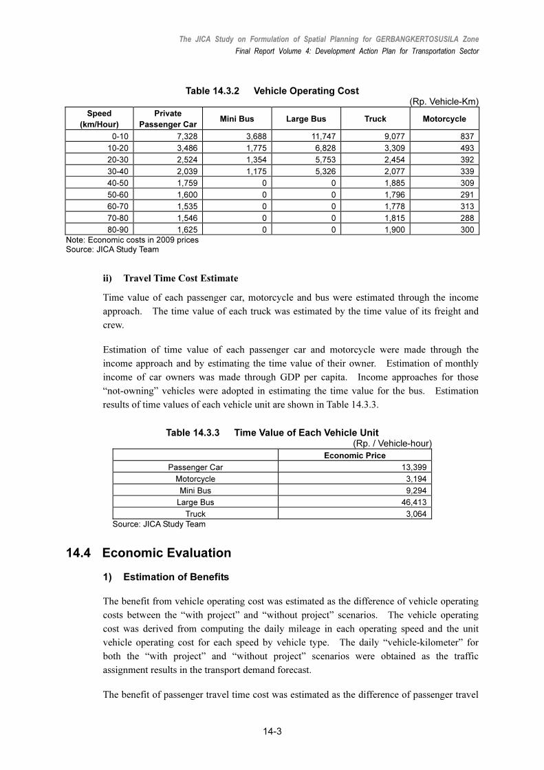
i) Vehicle Operation Cost (VOC)
Unit vehicle operating costs were estimated by the representative vehicles and operating
speed in 2009 prices, as shown in Table 14.3.2.
The JICA Study on Formulation of Spatial Planning for GERBANGKERTOSUSILA Zone
Final Report Volume 4: Development Action Plan for Transportation Sector
14-3
Table 14.3.2 Vehicle Operating Cost (Rp. Vehicle-Km)
Speed
(km/Hour)
Private
Passenger Car Mini Bus Large Bus Truck Motorcycle
0-10 7,328 3,688 11,747 9,077 837
10-20 3,486 1,775 6,828 3,309 493
20-30 2,524 1,354 5,753 2,454 392
30-40 2,039 1,175 5,326 2,077 339
40-50 1,759 0 0 1,885 309
50-60 1,600 0 0 1,796 291
60-70 1,535 0 0 1,778 313
70-80 1,546 0 0 1,815 288
80-90 1,625 0 0 1,900 300
Note: Economic costs in 2009 prices Source: JICA Study Team
ii) Travel Time Cost Estimate
Time value of each passenger car, motorcycle and bus were estimated through the income
approach. The time value of each truck was estimated by the time value of its freight and
crew.
Estimation of time value of each passenger car and motorcycle were made through the
income approach and by estimating the time value of their owner. Estimation of monthly
income of car owners was made through GDP per capita. Income approaches for those
“not-owning” vehicles were adopted in estimating the time value for the bus. Estimation
results of time values of each vehicle unit are shown in Table 14.3.3.
Table 14.3.3 Time Value of Each Vehicle Unit (Rp. / Vehicle-hour)
Economic Price
Passenger Car 13,399
Motorcycle 3,194
Mini Bus 9,294
Large Bus 46,413
Truck 3,064
Source: JICA Study Team
14.4 Economic Evaluation
1) Estimation of Benefits
The benefit from vehicle operating cost was estimated as the difference of vehicle operating
costs between the “with project” and “without project” scenarios. The vehicle operating
cost was derived from computing the daily mileage in each operating speed and the unit
vehicle operating cost for each speed by vehicle type. The daily “vehicle-kilometer” for
both the “with project” and “without project” scenarios were obtained as the traffic
assignment results in the transport demand forecast.
The benefit of passenger travel time cost was estimated as the difference of passenger travel
The JICA Study on Formulation of Spatial Planning for GERBANGKERTOSUSILA Zone
Final Report Volume 4: Development Action Plan for Transportation Sector
14-4
time cost between the “with project” and “without project” scenarios. The passenger time
cost is derived from the computed daily passenger-hour and the unit passenger time cost by
vehicle type. The daily passenger-hour for both scenarios was obtained from traffic
assignment results.
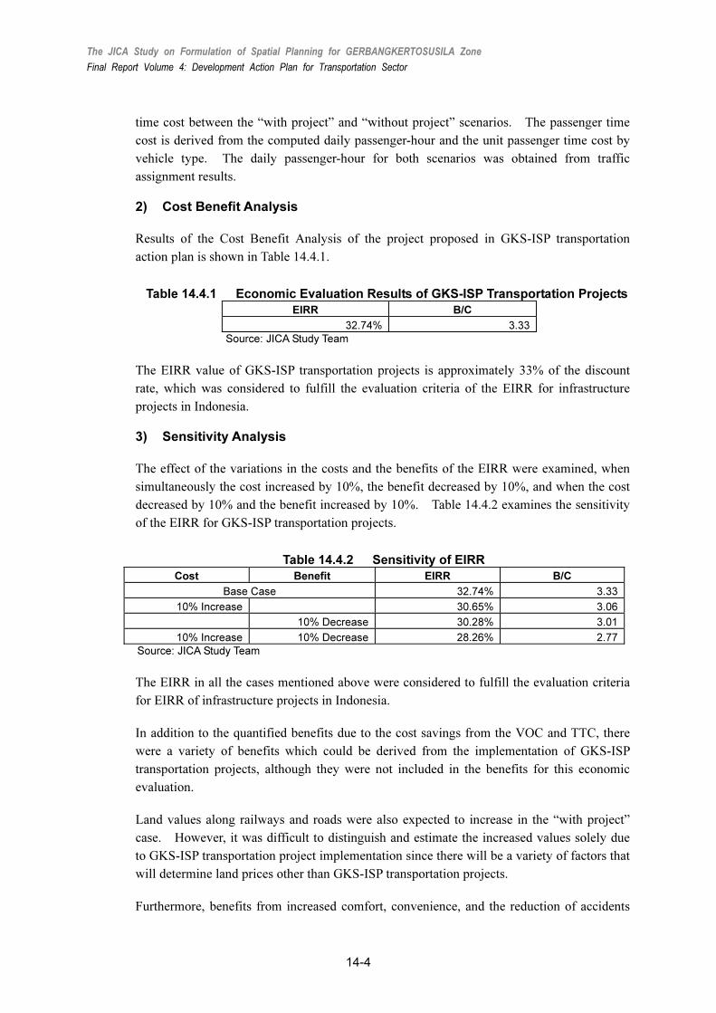
2) Cost Benefit Analysis
Results of the Cost Benefit Analysis of the project proposed in GKS-ISP transportation
action plan is shown in Table 14.4.1.
Table 14.4.1 Economic Evaluation Results of GKS-ISP Transportation Projects
EIRR B/C
32.74% 3.33
Source: JICA Study Team
The EIRR value of GKS-ISP transportation projects is approximately 33% of the discount
rate, which was considered to fulfill the evaluation criteria of the EIRR for infrastructure
projects in Indonesia.
3) Sensitivity Analysis
The effect of the variations in the costs and the benefits of the EIRR were examined, when
simultaneously the cost increased by 10%, the benefit decreased by 10%, and when the cost
decreased by 10% and the benefit increased by 10%. Table 14.4.2 examines the sensitivity
of the EIRR for GKS-ISP transportation projects.
Table 14.4.2 Sensitivity of EIRR
Cost Benefit EIRR B/C
Base Case 32.74% 3.33
10% Increase 30.65% 3.06
10% Decrease 30.28% 3.01
10% Increase 10% Decrease 28.26% 2.77
Source: JICA Study Team
The EIRR in all the cases mentioned above were considered to fulfill the evaluation criteria
for EIRR of infrastructure projects in Indonesia.
In addition to the quantified benefits due to the cost savings from the VOC and TTC, there
were a variety of benefits which could be derived from the implementation of GKS-ISP
transportation projects, although they were not included in the benefits for this economic
evaluation.
Land values along railways and roads were also expected to increase in the “with project”
case. However, it was difficult to distinguish and estimate the increased values solely due
to GKS-ISP transportation project implementation since there will be a variety of factors that
will determine land prices other than GKS-ISP transportation projects.
Furthermore, benefits from increased comfort, convenience, and the reduction of accidents

The JICA Study on Formulation of Spatial Planning for GERBANGKERTOSUSILA Zone
Final Report Volume 4: Development Action Plan for Transportation Sector
14-5
were not regarded as quantitative benefits in the economic evaluation as they were difficult
to define in monetary terms.
The value of EIRR was 32.74%, which is a highly appreciated level fulfilling the evaluation
criteria for EIRR of infrastructure projects in Indonesia.

ORGANIZATIONAL AND INSTITUTIONAL
ARRANGMENTS
The JICA Study on Formulation of Spatial Planning for GERBANGKERTOSUSILA Zone
Final Report Volume 4: Development Action Plan for Transportation Sector
15-1
15. ORGANIZATIONAL AND
INSTITUTIONAL ARRANGEMENTS
15.1 Establishment of a Transportation Authority
Establishment of a new agency, such as a transportation authority, is strongly recommended
to make consistent a metropolitan-wide transportation system development plan and to
manage transportation demand in the GKS. However, if it needs time to establish such a
new agency, a planning commission is to be established to pursue the tasks in short term.
The Study Team recommends to establish a transportation authority for the GKS in the short
term and to envisage the next step to be an establishment of an urban development authority.
1) GKS Transportation Planning Commission
The GKS Transportation Planning Commission is set up under the direction of the central
ministries, consisting of transport-related personnel from provincial and local governments.
This executive body shall consist of heads of respective provincial and local governments, as
well as representatives from the ministries, such as Ministry of Public Works, Ministry of
Transportation, and BAPPENAS (National Development Planning Agency). Its main
functions are to: 1) coordinate respective transportation planning at local governments into
an incorporated regional transportation plan, 2) conduct research and survey for
transportation planning, 3) coordinate studies in the region to be utilized for an integrated
transportation planning, and 4) manage the data collected through the Study particularly the
surveys to be used for academic research, planning purpose, and so on. A permanent
secretariat is established to support the commission and carry out daily operations. Funding
for the commission and secretariat shall in the form of contribution by the commission
members.
2) GKS Transportation Authority
The GKS Transportation Authority is established as an independent public corporation,
which has main accountability to the public, not only to the central, provincial, or local
governments. The authority would be endorsed by either presidential decree or government
law to stand as an independent public corporation. It oversees all land transportation issues
and has main responsibilities to: 1) formulate regional transportation policy, 2) formulate
integrated transportation planning, including road network development, railway (and MRT)
development, traffic management and public transportation system management, 3)
implement the integrated transportation planning and programs, 4) issue licenses and control
public transportation with bus route license, public transport business license, bus terminal
development permission, and so on, 5) regulate public transport services, such as BRT, MRT,
and so on, 6) support development of toll and non-toll (intercity) road network, and 7) carry

The JICA Study on Formulation of Spatial Planning for GERBANGKERTOSUSILA Zone
Final Report Volume 4: Development Action Plan for Transportation Sector
15-2
out traffic management measures, such as road pricing, and park and ride.
The authority would be operated by the revenue from financial contribution or subsidy from
Surabaya and the relevant local governments. As an independent corporation, however, its
primary task is to be financially sovereign and it should be underlined that a disclosure of
financial status is one of the most important aspects to secure its position as a public
corporation offering public services to users in the region. As a public corporation, it could
also raise fund from the capital market by issuing corporate bond.
3) Undertakings by the Transportation Authority
(1) Road Pricing
Road pricing will be adopted against the vehicles currently running on the congested streets
in the CBD of Surabaya. A considerable number of vehicles, however, come from the
outside of Kota Surabaya. In this context, implementation and management of road pricing
should be undertaken by the GKS Transportation Authority including preparation tasks for
road pricing.
(2) MRT
MRT is expected to be a key public transportation system in the Surabaya metropolitan area
and substantial patronage would also be obtained from the outside of Surabaya. In addition,
the route, especially ITS – Menganti line (W11), is proposed to extend beyond the boundary
of Kota Surabaya. Considering these circumstances, the infrastructure construction work
will be taken care of by the GKS Transportation Authority, and a new public or private
enterprise will undertake the operation and management of MRT. The GKS Transportation
Authority will share the cost for the infrastructure development of MRT, while the cost for
rolling stocks and operation and maintenance cost are the expenditure for the enterprise.
(3) BRT
Usually, road widening and the other related facility-development will be implemented under
the responsibilities of the central and local governments. Thus, consistent implementation
of the project beyond the administration boundary is required. Therefore, the GKS
Transportation Authority will undertake management of infrastructure development for BRT
including necessary widening of arterial roads or preparation of the centermost lane(s).
Actual road maintenance work of the road sections of BRT will be undertaken by the local
government, though necessary expenses may be appropriated by the GKS Transportation
Authority. Trunk bus operation services will be provided by private bus companies.
(4) Toll Road
Since the proposed toll roads will connect many subcenters in the GKS in order to support
regional development and to increase the mobility in the region, it is preferable for the GKS
Transportation Authority to take comprehensive planning coordination and implementation
including private-sector participation.

The JICA Study on Formulation of Spatial Planning for GERBANGKERTOSUSILA Zone
Final Report Volume 4: Development Action Plan for Transportation Sector
15-3
(5) Area Traffic Control System
Traffic management including ATCS (area traffic control system) and traffic information
system comprises an important component to alleviate traffic congestion and fully maximize
the capacity of roads and related facilities. In addition, at least Kota Surabaya and the
surrounding kabupatens have close relation in the implementation of this project. In this
view, the GKS Transportation Authority will undertake management of control system
development.
15.2 Private Sector Involvement in Transportation Development
Public transportation enterprises, namely, Perum Damri, a state-owned bus company and PT.
KA, a state-owned railway company, should be rationalized. Although privatization is yet
to be discussed further, the rationalization and efficiency of these companies are the
conditions for the private-sector participation.
Furthermore, regulations on private investment in transportation sector should be reviewed
and modified to provide sound investment environment for the private sector in
transportation business. This includes toll rate setting mechanism and provision of
development rights. The role and responsibility sharing system between the public and
private sectors should be clearly determined.
Provision of the land development rights to private investors in the surrounding area of
railway stations or interchanges of toll roads will make it possible to internalize the
development benefits of transportation system development. This, however, should be
done in a manner well-planned and controlled in consistency with the land use plan.
15.3 Transportation System Development with Urban Development
Transportation system development would bring about direct and indirect benefits to the
society. Indirect benefits such as increase in land value along the transportation corridor,
however, cannot be absorbed by the transportation system development project. The
following concepts therefore attempt to internalize the development benefits of
transportation system.
1) Internalization of Development Benefit of Mass Transit System
Generally speaking, the beneficiaries of a rail-based mass transit system are two distinct
groups: mass transit passengers and landowners along the route. Passengers of public
transportation systems will benefit from fast and comfortable public transport services in
exchange for fares that they pay.
Along the route, landowners/landlords enjoy the advancement in the value of their properties
due to their proximity to the stations. They will receive the development benefit when
selling the land in the property market or when they raise the rent they charge their tenants.
Property tax is a mechanism to absorb such capital gains in the long run. However, it
cannot mitigate the financial burden, which the public sector has to shoulder when
The JICA Study on Formulation of Spatial Planning for GERBANGKERTOSUSILA Zone
Final Report Volume 4: Development Action Plan for Transportation Sector
15-4
developing a transportation system.
There are two practical methods for the public sector to instantly absorb the property-related
benefit or to mitigate its financial burden. They are:
• To involve frontage landowners in the construction of a station and its pedestrian
facilities, and
• To designate a Special Development Zone where urban renewal is necessary but difficult
for the landowners to carry out alone, making the landowners decide to sell their
development right to an internationally competitive developer.
2) Internalization of Development Benefit of Toll Roads
Toll road business is not an easy business to enter into due to legalities of biddings and many
economic uncertainties. In addition, it seems impossible to make the viability financially
feasible on some sections with least traffic. In such a case, it can be considered to give the
investors area-development permission near a toll road interchange to meet prospective
regional development context in combination with toll road business. This may relieve the
financial burden of the investors, and could promote the toll road business with a view to
overcoming financial problems.

CONCLUSION
The JICA Study on Formulation of Spatial Planning for GERBANGKERTOSUSILA Zone
Final Report Volume 4: Development Action Plan for Transportation Sector
16-1
16. CONCLUSION
In a megalopolis like the GKS zone where 20.7 million trips are made in a day, it goes
without saying that mass transit system is needed to meet the huge travel demand. If
financially possible, it is desirable to develop a rail-based transportation system, which is not
disturbed by ordinary road traffic. The rail-based transportation system, however, requires
a considerable amount of cost for development. Consequently, it seems difficult to develop
many rail-based systems under the current level of budget allocated to the transportation
sector.
On the other hand, at present buses run at low speeds because buses are stuck in general
traffic congestion on roads, thus punctuality of operation is not ensured. Not a few
residents now try to avoid using buses because of issues of security, inconvenience, and lack
of comfort, and they are shifting to motorcycles. Therefore, a higher level of public
transportation service should urgently be provided to prevent the shift from public to private
modes of transportation. Furthermore, having merely one route is not enough to attract
people to public transportation use but an extensive network should be formulated like a web
to cover the major travel demand in the Surabaya metropolitan area.
On the other hand, for the majority of the residents, the ability to pay for transportation may
not be so high; hence, it is difficult to set high public transportation fares which enable the
private sector to provide a high level of public transportation services.
Therefore, in the short term and medium term, the public transportation network should be
formulated by combining the maximum use of the existing railway network and bus/feeder
bus system which would complement the railway network. In the long run, a rail-based
transportation system is definitely needed to provide a higher level of services as well as a
higher passenger capacity. Introduction of BRT also ensures the space for future public
transportation system development with higher level of services.
Improvement of public transportation services alone cannot suppress the deeply rooted
preference to use private modes of transportation; therefore, in the long term, traffic restraint
scheme such as road pricing should be employed in the congested area in the central part of
Surabaya where traffic congestion is often observed.
Another important measure is to support subcenters in and around the GKS and to distribute
urban functions, which currently concentrate in Surabaya. By alternating the urban
structure, traffic congestion problem would be alleviated to some extent.
Although promotion of public transportation is the most important policy to alleviate
transportation problem in the action plan, road network has not been well developed and the
capacity is significantly short especially outside Surabaya. In particular, progress of road
The JICA Study on Formulation of Spatial Planning for GERBANGKERTOSUSILA Zone
Final Report Volume 4: Development Action Plan for Transportation Sector
16-2
network development has not caught up with the expansion of urbanized area; therefore,
road network development is also important in the suburbs of the GKS.
Above all, cooperation of the citizens is indispensable for implementation of the action plan.
It goes without saying that they have to be well-informed about the plan. This can be
accomplished through such occasions as public hearings and stakeholder meetings, and their
opinions should be incorporated in the plan; the effects of the project implementation should
also be monitored. It is important that there be accountability by the government.
Transparency is of significance to gaining public acceptance and cooperation; thus an
information dissemination mechanism should be urgently established. The Study team
recommends, as a part of the action plan, to develop an urban transportation database system
and a transportation performance monitoring system.
Finally, legal framework is needed to materialize the action plan by relevant government
agencies, thus it is recommended to draft a new law, or at least a presidential decree, on the
transportation action plan for the GKS.