airborne measurements programs - asdc.asi.it airborne measurements programs francesco cairo istituto...
TRANSCRIPT

Airborne Measurements Programs
Francesco Cairo
Istituto di Scienze dell'Atmosfera e
del Clima, ISAC-CNR Roma
10th AGILE workshop
Frascati, April 18 2012

Summary
Why airborne measurements
Available platforms in Europe and USA
Ongoing and future activity
10th AGILE workshop Frascati, April 18 2012
Outlook

Observation Systems
Satellite: global coverage
Ground remote sensing: fixed location
Instrumented aircraft: mobile, in situ
Airborne platforms vastly extend the range of scientific
exploration that can fill critical gaps in data about our
atmosphere and earth system
10th AGILE workshop Frascati, April 18 2012

ATC and Air Worthyness limitations
Fly almost horizontally ( 15 m/s max
ascent/descent rate)
Airflow disturbance
Limited payload, space, endurance
Instrumented aircraft: Constraints
Speed: 100 m/s (turboprop)
200 m/s (jet) 10th AGILE workshop Frascati, April 18 2012

Objectives: To provide scientists with access at equal terms to the most
complete range of research infrastructures
To develop trans-national access to national infrastructures
To reduce redundancy and fill the gaps
To promote the use of research infrastructures, especially for
young scientists from countries where such infrastructures are
lacking
EUFAR is an Integrating Activity of the 7th EU Framework Program for
Research Infrastructures
A survey of european research aircraft:
EUFAR - Toward an integrated European fleet
25 aircraft or instruments, 205 users, 520 flight hours
Networking (2 M€) , TA (3 M€), JRA (2,3 M €), MGT (0,7 M€)
TOTAL : 8 M€
10th AGILE workshop Frascati, April 18 2012
• To provide access to research aircraft or instrumentation that is not available via the user’s own national research funding.
• Available to both expert and non-expert users
• Principal eligibility criteria:
• The proposer and the majority of the user group should be employed at institution in an EU Member State or Associated State
• The infrastructure (aircraft or instrumentation) to which they propose access should be from a different EU Member State
Aims of Transnational Access in EUFAR
10th AGILE workshop Frascati, April 18 2012

CATEGORIES OPERATORS
1. Strato. jet 2. Jets 3. Large A/C 4. Medium A/C 5. Small A/C
Geophysica EEIG Geophysica
DLR HALO Cessna 208B
NLR Citation
ENVISCOPE Learjet Partenavia
SAFIRE F-20 ATR-42 Piper-Aztec
MetOffice BAe-146
NERC Do-228
INTA 2 CASA-212
TAU King-Air 200
GTK Twin-Otter
Caravan
TU-BS Do-128
FUB Cessna 207
TMG-ASK-16
UNIMAN C-182
CNR-IBIMET ky-Arrow
IFU Microlight
TOTAL AIRCRAFT : 24 1 4 2 8 9
k€ /flight hour: 16 9 - 28 9 - 11 3 to 6 0.8 to 3
10th AGILE workshop Frascati, April 18 2012

10th AGILE workshop Frascati, April 18 2012

Currently an MoU has been signed between MDB and key
users defining the frame of the cooperation, while
contracts are negotiated for the individual missions.
Strato-jets : M55 Geophysica
10th AGILE workshop Frascati, April 18 2012
Ceiling: 65,000 ft
Range: 4000 km
Endurance: 5 hrs
Payload: 2250 kg
www.geophysica-eeig.eu

50,000 ft
Range: 12000 km
Endurance : 10 hrs
Payload: 3000 kg
http://www.halo.dlr.de/
High altitude jets: G-550 Halo
10th AGILE workshop Frascati, April 18 2012
Dr. Helmut Ziereis
DLR - Oberpfaffenhofen
Institut für Physik der Atmosphäre
Münchner Straße 20
D-82234 Weßling
Tel. +49 (0) 8153 28
2542
Fax: +49 (0) 8153 28 1841
DLR (Deutsches Zentrum für Luft- und
Raumfahrt) and MPG (Max-Planck-
Gesellschaft) are the main promoters of
this major research facility ithat will be
open to German as well as international
users.
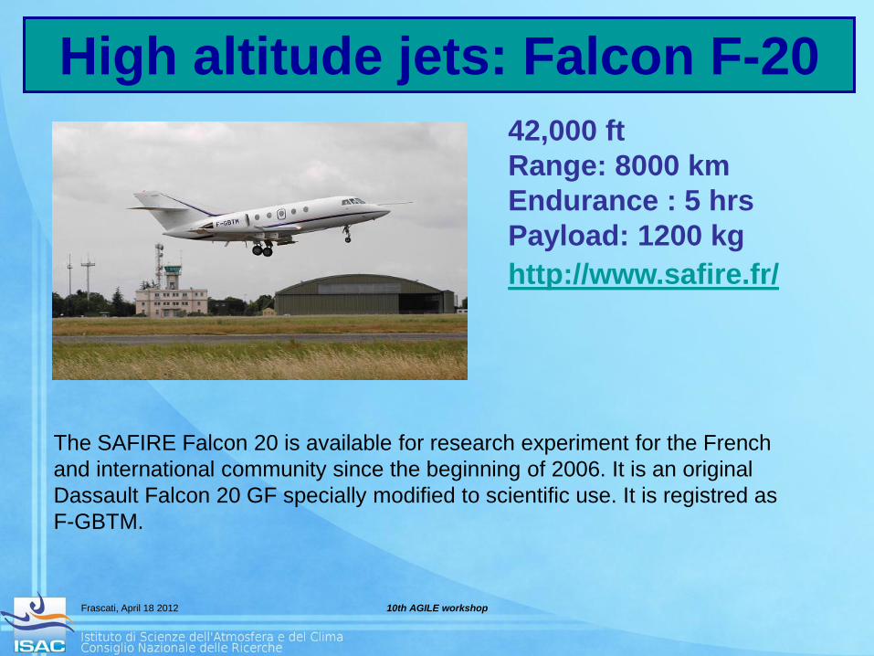
42,000 ft
Range: 8000 km
Endurance : 5 hrs
Payload: 1200 kg
http://www.safire.fr/
High altitude jets: Falcon F-20
10th AGILE workshop Frascati, April 18 2012
The SAFIRE Falcon 20 is available for research experiment for the French
and international community since the beginning of 2006. It is an original
Dassault Falcon 20 GF specially modified to scientific use. It is registred as
F-GBTM.

IAGOS-ERI is one of the new European Research Infrastructures on the ESFRI Roadmap 2006, to establish and operate a distributed infrastructure for long term observations of atmospheric composition, from a fleet of 10-20 aircraft.
Commercial aircraft
10th AGILE workshop Frascati, April 18 2012
IGAC newsletter 37

USA platforms
10th AGILE workshop Frascati, April 18 2012
ER-2 NASA Dryden Flight Center:
70,000 ft
Range: 8000 km
Endurance : 10 hrs
Payload: 1300 kg http://www.nasa.gov/centers/dryden/aircraft/ER-2/index.html
WB-57 NASA Johnson Space Flight Center:
60,000 ft
Range: 4000 km
Endurance : 8 hrs
Payload: 3000 kg http://www.JSC-aircraft-ops.jsc.nasa.gov/wb57/index.html
PROTEUS Northrop Grumman Corp.:
55,000 ft
Range: 4000 km
Endurance : 8 hrs
Payload: 1000 kg http://www.scaled.com/projects/proteusl

Toward the scientific use of UAS
10th AGILE workshop Frascati, April 18 2012

Global Hawk – New Capability for
High Altitude, Long Endurance Earth Science
Configuration
• Wingspan: 116 ft
• Length: 44 ft
• Unmanned vehicle
• Highly reliable, fully
autonomous control
Performance
• Endurance > 30 hours
• Range > 20,000 km
• Altitude > 19 km
NASA has acquired two
Global Hawk aircraft for
Earth Science missions
10th AGILE workshop Frascati, April 18 2012

LEO satellites:
global coverage few minutes of observational time on target, twice per day
vertical (> 1-2 km) horizontal (10 km) resolution
GEO satellites:
coverage over a vast regions (1/6th of Earth) continuous coverage,
vertical (>5 km) horizontal (1 km) resolution
development ~5-10 years
Aircraft:
sub-synoptic coverage, few hours of observational time on target,
vertical (> 0.01km) horizontal (> 0.1 km) resolution
development ~5-10 months
10th AGILE workshop
Frascati, April 18 2012
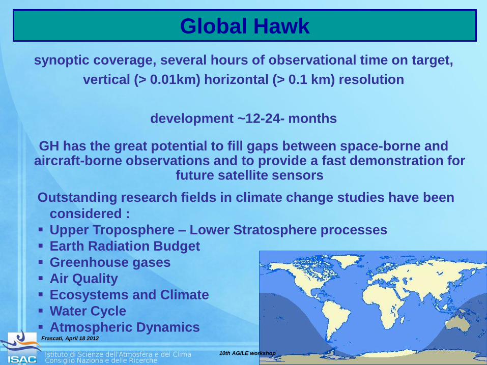
Global Hawk (GH):
synoptic coverage, several hours of observational time on target,
vertical (> 0.01km) horizontal (> 0.1 km) resolution
development ~12-24- months
GH has the great potential to fill gaps between space-borne and aircraft-borne observations and to provide a fast demonstration for
future satellite sensors
Outstanding research fields in climate change studies have been
considered :
Upper Troposphere – Lower Stratosphere processes
Earth Radiation Budget
Greenhouse gases
Air Quality
Ecosystems and Climate
Water Cycle
Atmospheric Dynamics
Global Hawk
10th AGILE workshop
Frascati, April 18 2012

• Payload ~ 680 kg
• Experiment power
–2.0 KW DC
–8.8 KVA AC
• In-flight command and control of instruments
Mounting Hard Points
Wing Pods
(future
capability)
Bay Under
the Nose
Pallets and Hatches
Mounting Rails
Multiple Payload
Options
Standardized
Instrument Interface
Data and
Power
Distribution
Global Hawk
Operations Center
Flight
Crew Science
Team
Mission support features
10th AGILE workshop Frascati, April 18 2012
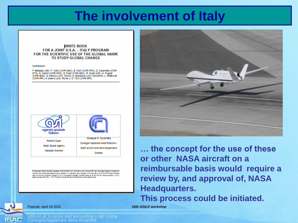
The involvement of Italy
10th AGILE workshop Frascati, April 18 2012
… the concept for the use of these
or other NASA aircraft on a
reimbursable basis would require a
review by, and approval of, NASA
Headquarters.
This process could be initiated.

ADELE
Gulfstream V
Nine flights for 37 hours in the air
10 km horizontal distance from
lightning area
1213 discharges seen
One interesting event detected
One example from a past mission
10th AGILE workshop
Frascati, April 18 2012
The low frequency of events may suggest
measurement on a routine basis
more than an event-chasing approach.
An agreement with commercial airliners
may be seeked for.
Air traffic policies toward flying over
intense thunderstoms may hamper the
chances of detection.
10th AGILE workshop Frascati, April 18 2012

Thank you!
10th AGILE workshop Frascati, April 18 2012