pulsed airborne lidar measurements of gsfc · fall’09 agu # a34c-05: laser sounder for remotely...
TRANSCRIPT

Fall’09 AGU # A34C-05: Laser Sounder for Remotely Measuring Atmospheric CO2 Concentrations
GSFC
jba -12/16/09 1
James B. Abshire
Haris Riris, Graham R. Allan*, Clark Weaver**,
William Hasselbrack*, Xiaoli Sun, Jianping Mao**
NASA Goddard Space Flight Center,Solar System Exploration Division, Greenbelt MD 20771
* -Sigma Space, ** GEST, Univ. of Maryland
Presentation to:
2009 Fall AGU, Paper # A34C-05
December 16, 2009
Supported by:
NASA ASCENDS, ESTO IIP program, Goddard IRAD programs
Pulsed Airborne Lidar Measurements of
Atmospheric CO2 Column Absorption & lineshapes
from 3-13 km altitudes
Fall’09 AGU # A34C-05: Laser Sounder for Remotely Measuring Atmospheric CO2 Concentrations
GSFC
jba -12/16/09 2
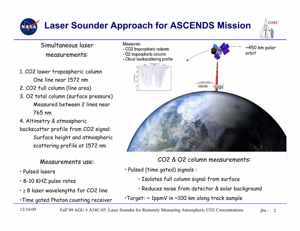
Laser Sounder Approach for ASCENDS Mission
Simultaneous lasermeasurements:
1. CO2 lower tropospheric columnOne line near 1572 nm
2. CO2 full column (line area)3. O2 total column (surface pressure)
Measured between 2 lines near765 nm
4. Altimetry & atmosphericbackscatter profile from CO2 signal:
Surface height and atmosphericscattering profile at 1572 nm
Measurements use:• Pulsed lasers
• 8-10 KHZ pulse rates
• ≥ 8 laser wavelengths for CO2 line
•Time gated Photon counting receiver
CO2 & O2 column measurements:• Pulsed (time gated) signals :
• Isolates full column signal from surface
• Reduces noise from detector & solar background
•Target: ~ 1ppmV in ~100 km along track sample
~450 km polarorbit
Fall’09 AGU # A34C-05: Laser Sounder for Remotely Measuring Atmospheric CO2 Concentrations
GSFC
jba -12/16/09 3
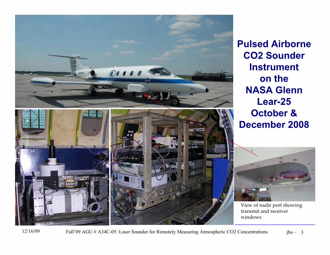
Pulsed AirborneCO2 Sounder
Instrumenton the
NASA GlennLear-25
October &December 2008
View of nadir port showingtransmit and receiverwindows
Fall’09 AGU # A34C-05: Laser Sounder for Remotely Measuring Atmospheric CO2 Concentrations
GSFC
jba -12/16/09 4
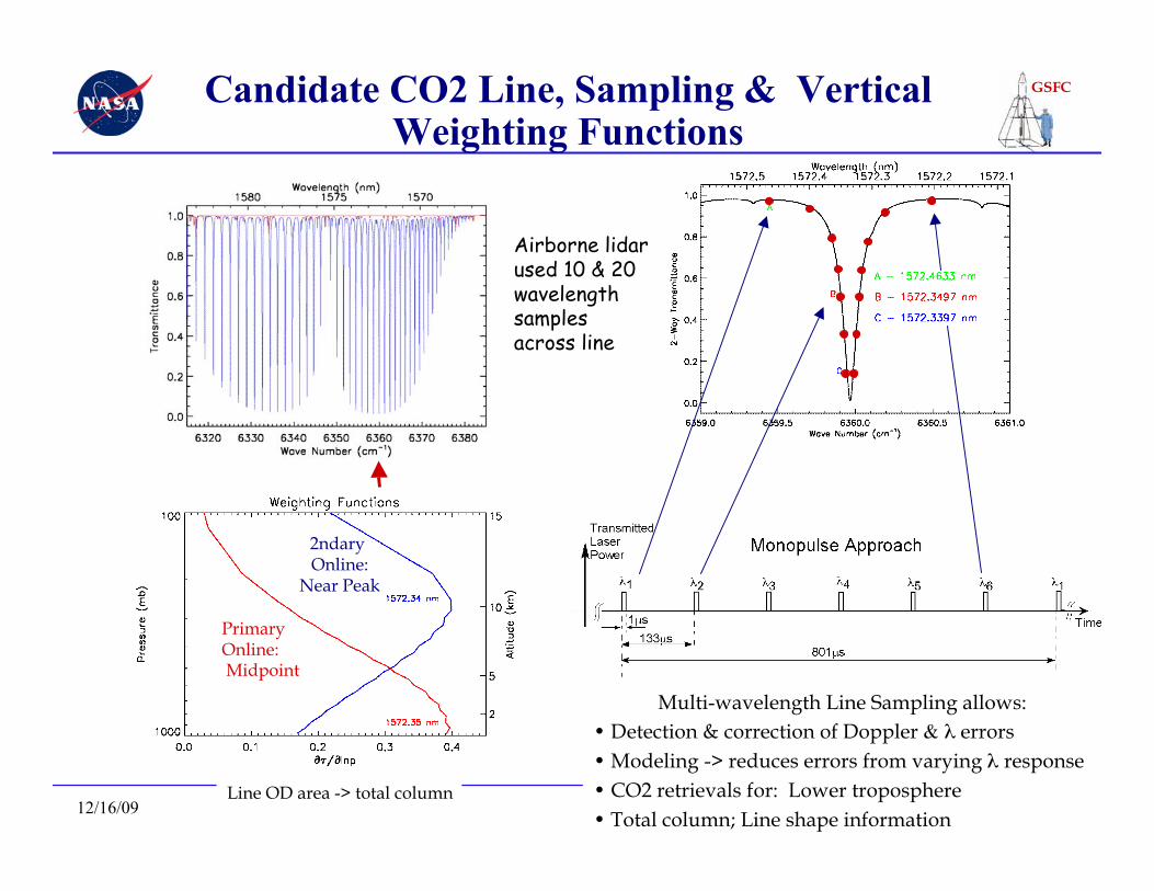
Candidate CO2 Line, Sampling & VerticalWeighting Functions
Primary Online: Midpoint
2ndary Online:
Near Peak TemperatureSensitivity
Airborne lidarused 10 & 20wavelengthsamplesacross line
Multi-wavelength Line Sampling allows:• Detection & correction of Doppler & λ errors• Modeling -> reduces errors from varying λ response• CO2 retrievals for: Lower troposphere• Total column; Line shape information
Line OD area -> total column
Fall’09 AGU # A34C-05: Laser Sounder for Remotely Measuring Atmospheric CO2 Concentrations
GSFC
jba -12/16/09 5
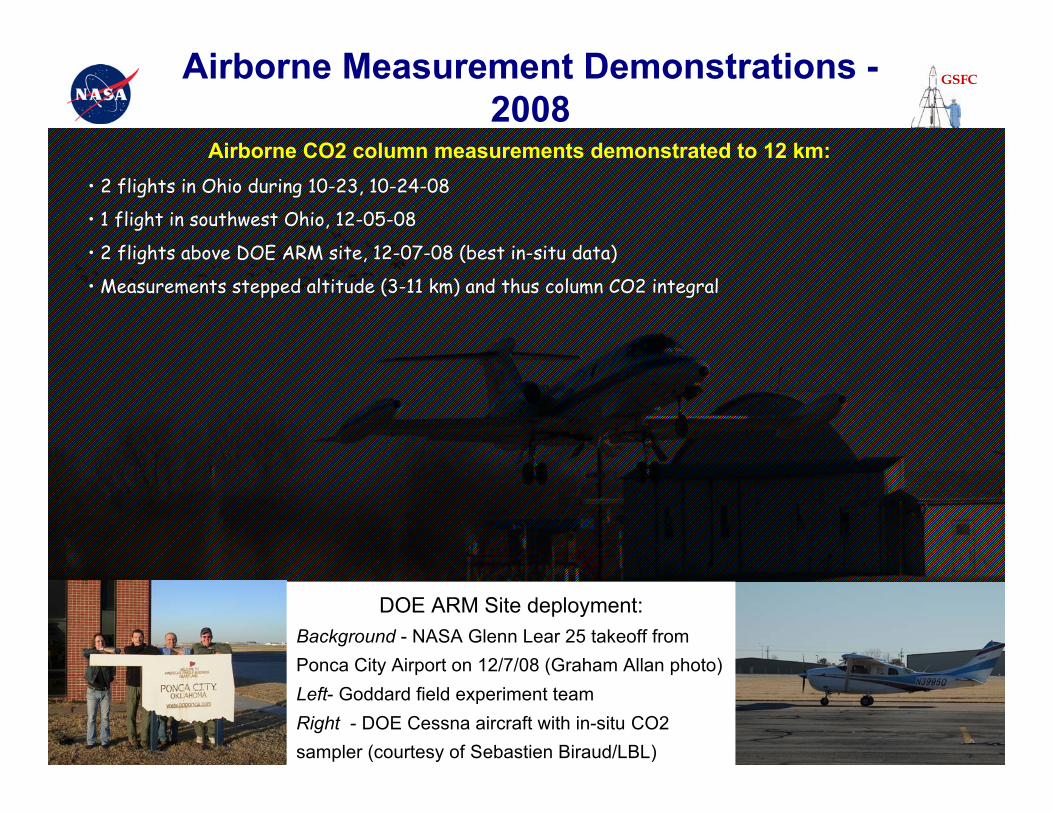
Airborne Measurement Demonstrations -2008
DOE ARM Site deployment:Background - NASA Glenn Lear 25 takeoff fromPonca City Airport on 12/7/08 (Graham Allan photo)Left- Goddard field experiment teamRight - DOE Cessna aircraft with in-situ CO2sampler (courtesy of Sebastien Biraud/LBL)
Airborne CO2 column measurements demonstrated to 12 km:• 2 flights in Ohio during 10-23, 10-24-08
• 1 flight in southwest Ohio, 12-05-08
• 2 flights above DOE ARM site, 12-07-08 (best in-situ data)
• Measurements stepped altitude (3-11 km) and thus column CO2 integral
Fall’09 AGU # A34C-05: Laser Sounder for Remotely Measuring Atmospheric CO2 Concentrations
GSFC
jba -12/16/09 6
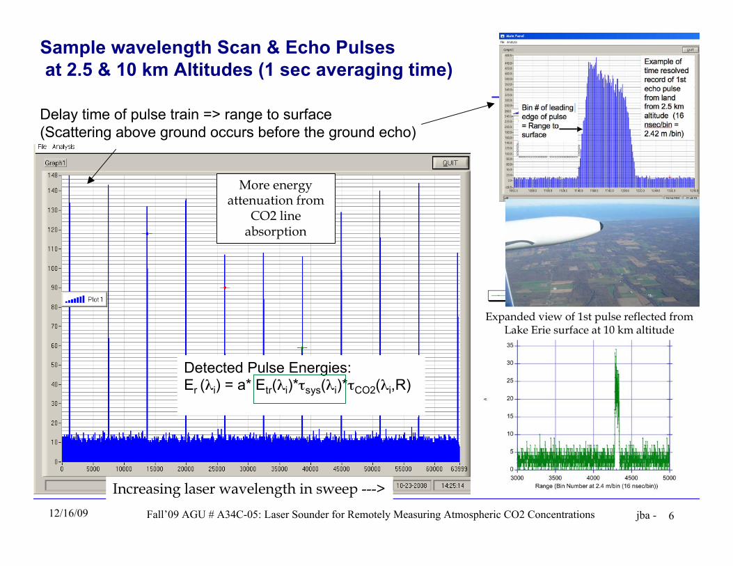
Sample wavelength Scan & Echo Pulses at 2.5 & 10 km Altitudes (1 sec averaging time)
Delay time of pulse train => range to surface(Scattering above ground occurs before the ground echo)
Increasing laser wavelength in sweep --->
Detected Pulse Energies:Er (λi) = a* Etr(λi)*τsys(λi)*τCO2(λi,R)
More energyattenuation from
CO2 lineabsorption
Expanded view of 1st pulse reflected fromLake Erie surface at 10 km altitude
Fall’09 AGU # A34C-05: Laser Sounder for Remotely Measuring Atmospheric CO2 Concentrations
GSFC
jba -12/16/09 7
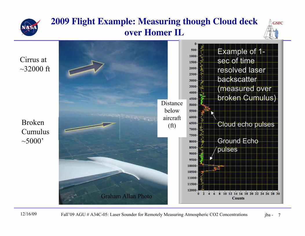
2009 Flight Example: Measuring though Cloud deckover Homer IL
Cirrus at~32000 ft
BrokenCumulus~5000’
Example of 1-sec of timeresolved laserbackscatter(measured overbroken Cumulus)
Cloud echo pulses
Ground Echopulses
Distancebelowaircraft
(ft)
Graham Allan Photo
Fall’09 AGU # A34C-05: Laser Sounder for Remotely Measuring Atmospheric CO2 Concentrations
GSFC
jba -12/16/09 8
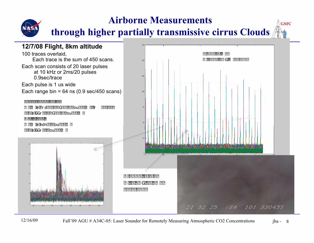
Airborne Measurementsthrough higher partially transmissive cirrus Clouds
12/7/08 Flight, 8km altitude100 traces overlaid,
Each trace is the sum of 450 scans.Each scan consists of 20 laser pulses
at 10 kHz or 2ms/20 pulses 0.9sec/trace
Each pulse is 1 us wideEach range bin = 64 ns (0.9 sec/450 scans)
� � � � � � � � � � � �� � � � � � � G� � � � � � � �� � � � � � � � �
� � � � � � � �� � �� � � � � � � � � � G� �� � � � � � � �
� � � � � � � � � � � � �� �� � e� r d� � � � � G� � � � � � ou� � � �� � � � r � � � � � �� � � e� GGr � � � � G� � � � � � ou� � � �� �� � � � � � � �� �� � e� ndn� � � � ou� � � �� �� � � e� GGr � � � � ou� � � �� �
Fall’09 AGU # A34C-05: Laser Sounder for Remotely Measuring Atmospheric CO2 Concentrations
GSFC
jba -12/16/09 9
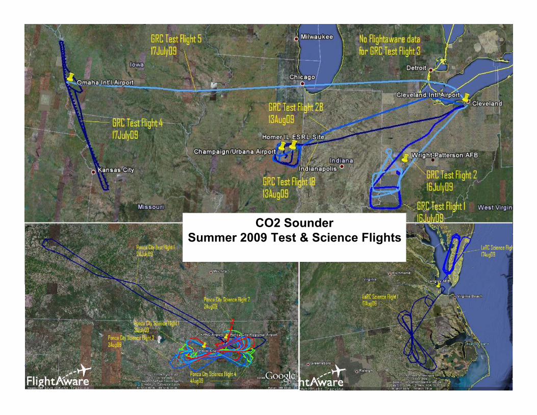
CO2 SounderSummer 2009 Test & Science Flights
Fall’09 AGU # A34C-05: Laser Sounder for Remotely Measuring Atmospheric CO2 Concentrations
GSFC
jba -12/16/09 10
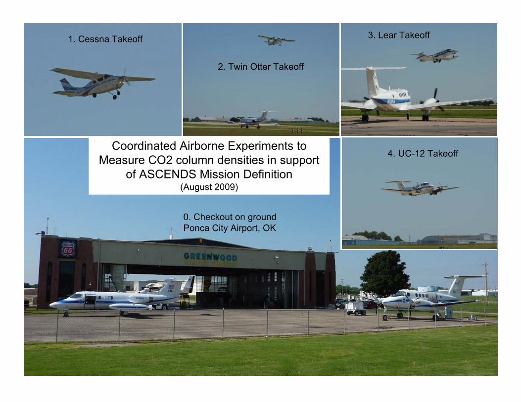
0. Checkout on groundPonca City Airport, OK
1. Cessna Takeoff
2. Twin Otter Takeoff
3. Lear Takeoff
4. UC-12 TakeoffCoordinated Airborne Experiments to
Measure CO2 column densities in supportof ASCENDS Mission Definition
(August 2009)
Fall’09 AGU # A34C-05: Laser Sounder for Remotely Measuring Atmospheric CO2 Concentrations
GSFC
jba -12/16/09 11
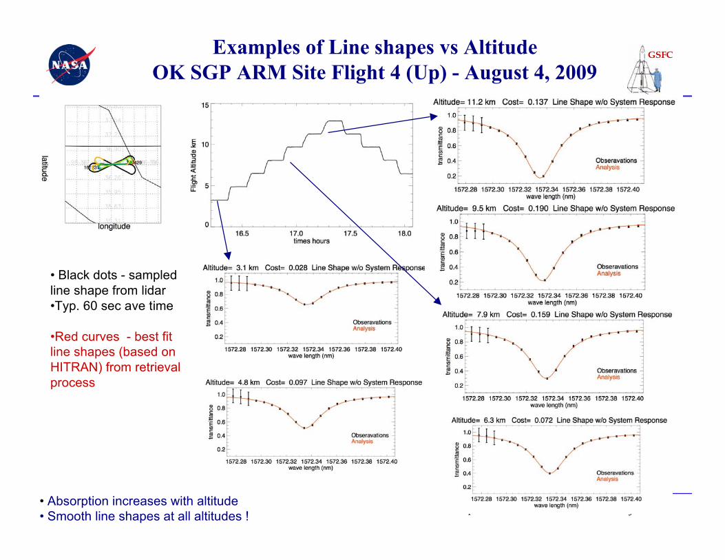
Examples of Line shapes vs AltitudeOK SGP ARM Site Flight 4 (Up) - August 4, 2009
• Absorption increases with altitude• Smooth line shapes at all altitudes !
• Black dots - sampledline shape from lidar•Typ. 60 sec ave time
•Red curves - best fitline shapes (based onHITRAN) from retrievalprocess
Fall’09 AGU # A34C-05: Laser Sounder for Remotely Measuring Atmospheric CO2 Concentrations
GSFC
jba -12/16/09 12
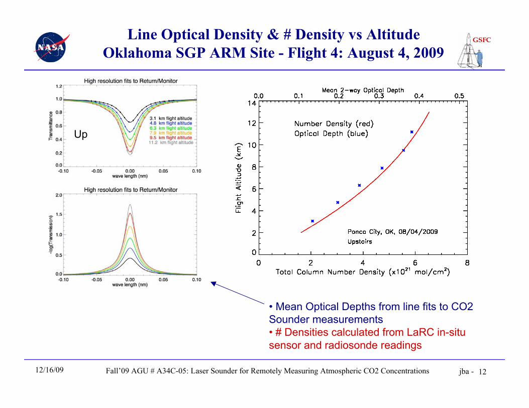
Line Optical Density & # Density vs AltitudeOklahoma SGP ARM Site - Flight 4: August 4, 2009
• Mean Optical Depths from line fits to CO2Sounder measurements• # Densities calculated from LaRC in-situsensor and radiosonde readings
Up
Fall’09 AGU # A34C-05: Laser Sounder for Remotely Measuring Atmospheric CO2 Concentrations
GSFC
jba -12/16/09 13
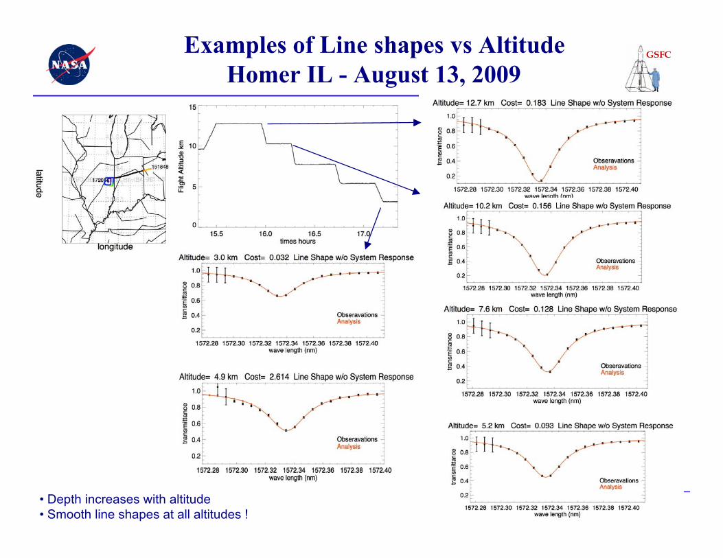
Examples of Line shapes vs AltitudeHomer IL - August 13, 2009
• Depth increases with altitude• Smooth line shapes at all altitudes !
Fall’09 AGU # A34C-05: Laser Sounder for Remotely Measuring Atmospheric CO2 Concentrations
GSFC
jba -12/16/09 14
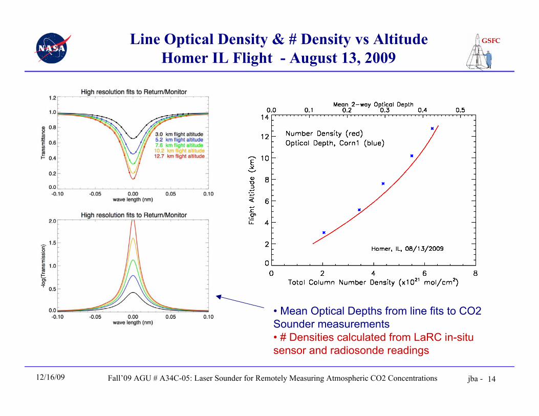
Line Optical Density & # Density vs AltitudeHomer IL Flight - August 13, 2009
• Mean Optical Depths from line fits to CO2Sounder measurements• # Densities calculated from LaRC in-situsensor and radiosonde readings
Fall’09 AGU # A34C-05: Laser Sounder for Remotely Measuring Atmospheric CO2 Concentrations
GSFC
jba -12/16/09 15
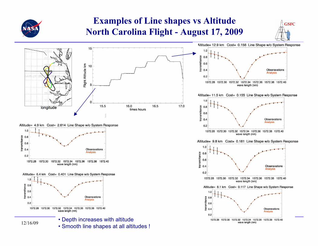
Examples of Line shapes vs AltitudeNorth Carolina Flight - August 17, 2009
• Depth increases with altitude• Smooth line shapes at all altitudes !
Fall’09 AGU # A34C-05: Laser Sounder for Remotely Measuring Atmospheric CO2 Concentrations
GSFC
jba -12/16/09 16
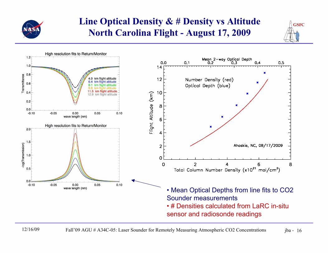
Line Optical Density & # Density vs AltitudeNorth Carolina Flight - August 17, 2009
• Mean Optical Depths from line fits to CO2Sounder measurements• # Densities calculated from LaRC in-situsensor and radiosonde readings
Fall’09 AGU # A34C-05: Laser Sounder for Remotely Measuring Atmospheric CO2 Concentrations
GSFC
jba -12/16/09 17
Summary• Airborne CO2 Lidar worked quite well in multiple flights, 3-13 km
• Measured optical depths increased with altitude, consistent with calculations
• Altimetry measurements & SNR consistent with theory
• CO2 calibrations and evaluations are ongoing
More information - A41C Poster Session, Thursday 8 am
A41C-0118. Signal to Noise Ratio Analysis of the Pulsed Airborne CO2 Lidar Measurements. X. Sun et al.
A41C-0119. Retrievals of column CO2 mixing ratio from airborne pulsed lidar measurements. C. J.Weaver; et al.
A41C-0121. Simulation Studies of Satellite Laser CO2 Mission Concepts. S. R. Kawa et al.
Acknowledgements
• NASA Headquarters - ASCENDS Mission definition• NASA ESTO IIP-7 program; Goddard IRAD program• NASA Glenn Aircraft Operations Office• NASA LaRC & ACCLAIM group (Ed Browell, Yonghoon Choi)
Fall’09 AGU # A34C-05: Laser Sounder for Remotely Measuring Atmospheric CO2 Concentrations
GSFC
jba -12/16/09 18
Thank you !