acronyms, definitions & hyperlinks quality/planning... · 7q10 the annual minimum 7-day...
TRANSCRIPT
NC
DW
Q N
EW
RIV
ER
BA
SIN
PLA
N:
GLo
SS
AR
y &
Hy
PE
RLI
Nk
S
201
1
10.1
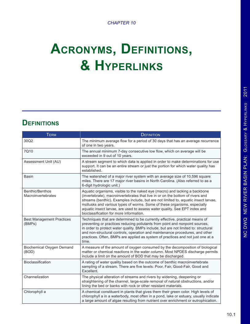
Definitions
TERm DEfINITIoN
30Q2 The minimum average flow for a period of 30 days that has an average recurrence of one in two years.
7Q10 The annual minimum 7-day consecutive low flow, which on average will be exceeded in 9 out of 10 years.
Assessment Unit (AU) A stream segment to which data is applied in order to make determinations for use support. It can be an entire stream or just the portion for which water quality has established.
Basin The watershed of a major river system with an average size of 10,596 square miles. There are 17 major river basins in North Carolina. (Also referred to as a 6-digit hydrologic unit.)
Benthic/Benthos Macroinvertebrates
Aquatic organisms, visible to the naked eye (macro) and lacking a backbone (invertebrate), macroinvertebrates that live in or on the bottom of rivers and streams (benthic). Examples include, but are not limited to, aquatic insect larvae, mollusks and various types of worms. Some of these organisms, especially aquatic insect larvae, are used to assess water quality. See EPT index and bioclassification for more information.
Best Management Practices (BMPs)
Techniques that are determined to be currently effective, practical means of preventing or practices reducing pollutants from point and nonpoint sources, in order to protect water quality. BMPs include, but are not limited to: structural and non-structural controls, operation and maintenance procedures, and other practices. Often, BMPs are applied as system of practices and not just one at a time.
Biochemical Oxygen Demand (BOD)
A measure of the amount of oxygen consumed by the decomposition of biological matter or chemical reactions in the water column. Most NPDES discharge permits include a limit on the amount of BOD that may be discharged.
Bioclassification A rating of water quality based on the outcome of benthic macroinvertebrate sampling of a stream. There are five levels: Poor, Fair, Good-Fair, Good and Excellent.
Channelization The physical alteration of streams and rivers by widening, deepening or straightening of the channel, large-scale removal of natural obstructions, and/or lining the bed or banks with rock or other resistant materials.
Chlorophyll a A chemical constituent in plants that gives them their green color. High levels of chlorophyll a in a waterbody, most often in a pond, lake or estuary, usually indicate a large amount of algae resulting from nutrient over enrichment or eutrophication.
CHAPTER 10
Acronyms, Definitions, & Hyperlinks

NC
DW
Q N
EW
RIV
ER
BA
SIN
PLA
N: G
LoS
SA
Ry &
Hy
PE
RLIN
kS 2011
10.2
TERm DEfINITIoN
Class B Waters protected for all Class C uses in addition to primary recreation. Primary recreational activities include swimming, skin diving, water skiing, and similar uses involving human body contact with water where such activities take place in an organized manner or on a frequent basis.
Class C Waters protected for uses such as secondary recreation, fishing, wildlife, fish consumption, aquatic life including propagation, survival and maintenance of biological integrity, and agriculture. Secondary recreation includes wading, boating, and other uses involving human body contact with water where such activities take place in an infrequent, unorganized, or incidental manner.
Class SA Tidal salt waters that are used for commercial shellfishing or marketing purposes and are also protected for all Class SC and Class SB uses. All SA waters are also HQW by supplemental classification.
Class SB Tidal salt waters protected for all SC uses in addition to primary recreation. Primary recreational activities include swimming, skin diving, water skiing, and similar uses involving human body contact with water where such activities take place in an organized manner or on a frequent basis.
Class SC All tidal salt waters protected for secondary recreation such as fishing, boating, and other activities involving minimal skin contact; fish and noncommercial shellfish consumption; aquatic life propagation and survival; and wildlife.
Class SWL These are saltwaters that meet the definition of coastal wetlands as defined by the Division of Coastal Management and which are located landward of the mean high water line or wetlands contiguous to estuarine waters as defined by the Division of Coastal Management.
Class WL Freshwater Wetlands are a subset of all wetlands, which in turn are waters that support vegetation that is adapted to life in saturated soil conditions. Wetlands generally include swamps, marshes, bogs, and similar areas. These waters are protected for storm and flood water storage, aquatic life, wildlife, hydrologic functions, filtration and shoreline protection.
Coastal Counties Twenty counties in eastern NC subject to requirements of the Coastal Area Management Act (CAMA). They include: Beaufort, Bertie, Brunswick, Camden, Carteret, Chowan, Craven, Currituck, Dare, Gates, Hertford, Hyde, New Hanover, Onslow, Pamlico, Pasquotank, Pender, Perquimans, Tyrrell and Washington.
Coastal Plain One of three major physiographic regions in North Carolina. Encompasses the eastern two-fifths of state east of the fall line (approximated by Interstate I-95).
Conductivity A measure of the ability of water to conduct an electrical current. It is dependent on the concentration of dissolved ions such as sodium, chloride, nitrates, phosphates and metals in solution.
Degradation The lowering of the physical, chemical or biological quality of a waterbody caused by pollution or other sources of stress.
Drainage Area Land surrounding and draining to a small creek, stream or river. Typically smaller than a subbwatershed.
Dystrophic Naturally acidic (low pH), “black-water” lakes which are rich in organic matter. Dystrophic lakes usually have low productivity because most fish and aquatic plants are stressed by low pH water. In North Carolina, dystrophic lakes are scattered throughout the Coastal Plain and Sandhills regions and are often located in marshy areas or overlying peat deposits. NCTSI scores are not appropriate for evaluating dystrophic lakes.
Effluent The treated liquid discharged from a wastewater treatment plant.Eolian Sediment deposited, produced, or eroded by windEPT Index This index is used to judge water quality based on the abundance and variety of
three orders of pollution sensitive aquatic insect larvae: Ephemeroptera (mayflies), Plecoptera (stoneflies) and Trichoptera (caddisflies).
Eutrophic Elevated biological productivity related to an abundance of available nutrients. Eutrophic lakes may be so productive that the potential for water quality problems such as algal blooms, nuisance aquatic plant growth and fish kills may occur.
NC
DW
Q N
EW
RIV
ER
BA
SIN
PLA
N:
GLo
SS
AR
y &
Hy
PE
RLI
Nk
S
201
1
10.3
TERm DEfINITIoN
Eutrophication The process of physical, chemical or biological changes in a lake associated with nutrient, organic matter and silt enrichment of a waterbody. The corresponding excessive algal growth can deplete dissolved oxygen and threaten certain forms of aquatic life, cause unsightly scums on the water surface and result in taste and odor problems.
Fall Line A geologic landscape feature that defines the line between the piedmont and coastal plain regions. It is most evident as the last set of small rapids or rock outcroppings that occur on rivers flowing from the piedmont to the coast.
Future Water Supply (FWS) Supplemental classification for waters intended as a future source of drinking, culinary, or food processing purposes. FWS would be applied to one of the primary water supply classifications (WS-I, WS-II, WS-III, or WS-IV). Currently no water bodies in the state carry this designation.
Geographic Information System An organized collection of computer hardware, software, geographic data and personnel designed to efficiently capture, store, update, manipulate, analyze and display all forms of geographically referenced information.
Habitat Degradation Identified where there is a notable reduction in habitat diversity or change in habitat quality. This term includes sedimentation, bank erosion, channelization, lack of riparian vegetation, loss of pools or riffles, loss of woody habitat, and streambed scour.
Headwaters Small streams that converge to form a larger stream in a watershed.High Quality Waters (HQW) Supplemental classification intended to protect waters which are rated excellent
based on biological and physical/chemical characteristics through Division monitoring or special studies, primary nursery areas designated by the Marine Fisheries Commission, and other functional nursery areas designated by the Marine Fisheries Commission. The following waters are HQW by definition: WS-I, WS-II, SA, ORW, Primary nursery areas (PNA) designated by the Marine Fisheries Commission, and Waters for which DWQ has received a petition for reclassification to either WS-I or WS-II.
Hydrilla The genus name of an aquatic plant - often considered an aquatic weed.Hydrologic Unit Code A watershed area defined by a national uniform hydrologic unit system that is
sponsored by the Water Resources Council. This system divides the country into regions, subregions, basins, subbasins, watersheds and subwatersheds. A hierarchical code consisting of two digits for each of the above six levels combined to form an 12-digit hydrologic unit (subwatershed). An 12-digit hydrologic unit generally covers an average of 40 square miles.
Hypereutrophic Extremely elevated biological productivity related to excessive nutrient availability. Hypereutrophic lakes exhibit frequent algal blooms, episodes of low dissolved oxygen or periods when no oxygen is present in the water, fish kills and excessive aquatic plant growth.
Impacted Waters Any site with 7.1% to 10.0% of AMS samples over a parameter’s standard will be considered Impacted as well as streams with a biological rating of Good-Fair. The term Impacted is not an official DWQ term and is used by the DWQ Planning Section to indicate streams with the potential of becoming impaired in the near future. These impacted waters are identified to allow better targeting and prioritizing of resources to prevent further degradation.
Impaired Term that applies to a waterbody that is not meeting the designated use criteria. See the Use Support Methodology for details as to how waters across the state are designated as Supporting, Not Rated or Impaired.
Impervious Incapable of being penetrated by water; non-porous.Loading Mass rate of addition of pollutants to a waterbody (e.g., kg/yr)Macroinvertebrates Animals large enough to be seen by the naked eye (macro) and lacking
backbones (invertebrate).Macrophyte An aquatic plant large enough to be seen by the naked eye.Mesotrophic Moderate biological productivity related to intermediate concentrations of available
nutrients. Mesotrophic lakes show little, if any, signs of water quality degradation while supporting a good diversity of aquatic life.

NC
DW
Q N
EW
RIV
ER
BA
SIN
PLA
N: G
LoS
SA
Ry &
Hy
PE
RLIN
kS 2011
10.4
TERm DEfINITIoN
NCIBI North Carolina Index of Biotic Integrity. A measure of the community health of a population of fish in a given waterbody.
Nonpoint Source A source of water pollution generally associated with rainfall runoff or snowmelt. The quality and rate of runoff of NPS pollution is strongly dependent on the type of land cover and land use from which the rainfall runoff flows. For example, rainfall runoff from forested lands will generally contain much less pollution and runoff more slowly than runoff from urban lands.
Notice of Violation (NOV) An NOV serve to alert the permittee of permit infractions and request that whatever caused the violation be corrected immediately. Many times these will not include a fine. Depending upon the severity of the violation, the permittee may receive a Notice of Violation and Assessment of a Civil Penalty, which will include a fine.
Nutrient Sensitive Waters (NSW) Supplemental classification intended for waters needing additional nutrient management due to being subject to excessive growth of microscopic or macroscopic vegetation.
Oligotrophic Low biological productivity related to very low concentrations of available nutrients. Oligotrophic lakes in North Carolina are generally found in the mountain region or in undisturbed (natural) watersheds and have very good water quality.
Outstanding Resource Waters (ORW)
All outstanding resource waters are a subset of High Quality Waters. This supplemental classification is intended to protect unique and special waters having excellent water quality and being of exceptional state or national ecological or recreational significance.
pH A measure of the concentration of free hydrogen ions on a scale ranging from 0 to 14. Values below 7 and approaching 0 indicate increasing acidity, whereas values above 7 and approaching 14 indicate a more basic solution.
Phytoplankton Aquatic microscopic plant life, such as algae, that are common in ponds, lakes, rivers and estuaries.
Piedmont One of three major physiographic regions in the state. Encompasses most of central North Carolina from the Coastal Plain region (near I-95) to the eastern slope of the Blue Ridge Mountains region.
Polychlorinated Biphenyls (PCBs)
PCBs are man-made chemicals that persist in the environment. There are a number of adverse health effect associated with exposure to PCBs.
Riparian Zone Vegetated corridor immediately adjacent to a stream or river. See also SMZ.Runoff Rainfall that does not evaporate or infiltrate the ground, but instead flows across
land and into waterbodies.Sedimentation The sinking and deposition of waterborne particles (e.g., eroded soil, algae and
dead organisms).Seeps Seeps are areas that remain wet due to groundwater seepage. The plant
community generally consists of a dense bed of wetland herbs.Silviculture Care and cultivation of forest trees; forestry.SOC Special Order by Consent. An agreement between the Environmental
Management Commission and a permitted discharger found responsible for causing or contributing to surface water pollution. The SOC stipulates actions to be taken to alleviate the pollution within a defined time. The SOC typically includes relaxation of permit limits for particular parameters, while the facility completes the prescribed actions. SOCs are only issued to facilities where the cause of pollution is not operational in nature (i.e., physical changes to the wastewater treatment plant are necessary to achieve compliance).
Species of Concern Species of Concern are those species about which NOAA’s National Marine Fisheries Service (NMFS) has some concerns regarding status and threats, but for which insufficient information is available to indicate a need to list the species under the Endangered Species Act (ESA).
Streamside Management Zone (SMZ)
The area left along streams to protect streams from sediment and other pollutants, protect streambeds, and provide shade and woody debris for aquatic organisms.
SU Standard unit; measurement of pH.

NC
DW
Q N
EW
RIV
ER
BA
SIN
PLA
N:
GLo
SS
AR
y &
Hy
PE
RLI
Nk
S
201
1
10.5
TERm DEfINITIoN
Subbasin A river basin is broken up into smaller subbasins areas with an average size of 700 square miles. (Subbasins are also referred to as 8-digit hydrologic units.)
Subwatershed A watershed is broken up into smaller subwatershed areas with an average size of 40 square miles. Subwatersheds are also referred to as 12-digit hydrologic units.)
Swamp Waters (SW) Supplemental classification intended to recognize those waters which have low velocities and other natural characteristics which are different from adjacent streams.
Targeted Local Watershed (TLW) A term used by the Ecosystem Enhancement Program that identifies priority areas for planning and restoration. These watershed boundaries are based on 14-digit hydrologic units created by the National Resource Conservation Service (NRCS) that are no longer used by the NRCS.
Total Maximum Daily Load (TMDL)
The amount of a given pollutant that a waterbody can assimilate and maintain its uses and water quality standards.
Tributary A stream that flows into a larger stream, river or other waterbody.Trophic Trophic classification is a relative description of a lake’s biological productivity,
which is the ability of the lake to support algal growth, fish populations and aquatic plants. The productivity of a lake is determined by a number of chemical and physical characteristics, including the availability of essential plant nutrients (nitrogen and phosphorus), algal growth and the depth of light penetration. Lakes are classified according to productivity: unproductive lakes are termed “oligotrophic”; moderately productive lakes are termed “mesotrophic”; and very productive lakes are termed “eutrophic”.
Trout Waters (Tr) Supplemental classification intended to protect freshwaters which have conditions which shall sustain and allow for trout propagation and survival of stocked trout on a year-round basis. This classification is not the same as the NC Wildlife Resources Commission's Designated Public Mountain Trout Waters designation.
Turbidity An expression of the optical property that causes light to be scattered and absorbed rather than transmitted in straight lines through a sample. All particles in the water that may scatter or absorb light are measured during this procedure. Suspended sediment, aquatic organisms and organic particles such as pieces of leaves contribute to instream turbidity.
Unique Wetland (UWL) Supplemental classification for wetlands of exceptional state or national ecological significance. These wetlands may include wetlands that have been documented to the satisfaction of the Environmental Management Commission as habitat essential for the conservation of state or federally listed threatened or endangered species.
Water Supply I (WS-I) Waters protected for all Class C uses plus waters used as sources of water supply for drinking, culinary, or food processing purposes for those users desiring maximum protection for their water supplies. WS-I waters are those within natural and undeveloped watersheds in public ownership. All WS-I waters are HQW by supplemental classification.
Water Supply II (WS-II) Waters used as sources of water supply for drinking, culinary, or food processing purposes where a WS-I classification is not feasible. These waters are also protected for Class C uses. WS-II waters are generally in predominantly undeveloped watersheds. All WS-II waters are HQW by supplemental classification.
Water Supply III (WS-III) Waters used as sources of water supply for drinking, culinary, or food processing purposes where a more protective WS-I or II classification is not feasible. These waters are also protected for Class C uses. WS-III waters are generally in low to moderately developed watersheds.
Water Supply IV (WS-IV) Waters used as sources of water supply for drinking, culinary, or food processing purposes where a WS-I, II or III classification is not feasible. These waters are also protected for Class C uses. WS-IV waters are generally in moderately to highly developed watersheds or Protected Areas.

NC
DW
Q N
EW
RIV
ER
BA
SIN
PLA
N: G
LoS
SA
Ry &
Hy
PE
RLIN
kS 2011
10.6
TERm DEfINITIoN
Water Supply V (WS-V) Waters protected as water supplies which are generally upstream and draining to Class WS-IV waters or waters used by industry to supply their employees with drinking water or as waters formerly used as water supply. These waters are also protected for Class C uses.
Watershed A subbasin is broken up into smaller watershed areas with an average size of 227 square miles. Watersheds are also referred to as 10-digit hydrologic units.)
Whole Effluent Toxicity (WET) The aggregate toxic effect of a wastewater measured directly by an aquatic toxicity test.
NC
DW
Q N
EW
RIV
ER
BA
SIN
PLA
N:
GLo
SS
AR
y &
Hy
PE
RLI
Nk
S
201
1
10.7
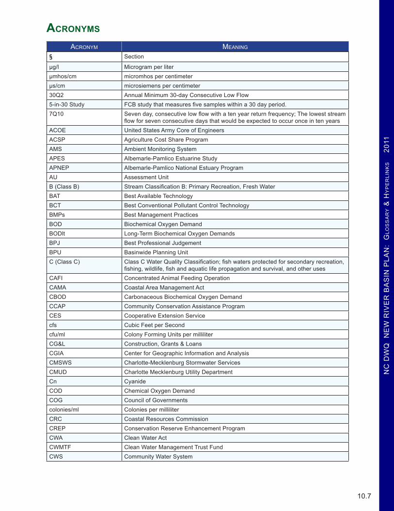
Acronyms
ACRoNym mEANING
§ Section
µg/l Microgram per literµmhos/cm micromhos per centimeterµs/cm microsiemens per centimeter30Q2 Annual Minimum 30-day Consecutive Low Flow5-in-30 Study FCB study that measures five samples within a 30 day period. 7Q10 Seven day, consecutive low flow with a ten year return frequency; The lowest stream
flow for seven consecutive days that would be expected to occur once in ten yearsACOE United States Army Core of EngineersACSP Agriculture Cost Share ProgramAMS Ambient Monitoring SystemAPES Albemarle-Pamlico Estuarine StudyAPNEP Albemarle-Pamlico National Estuary ProgramAU Assessment UnitB (Class B) Stream Classification B: Primary Recreation, Fresh WaterBAT Best Available TechnologyBCT Best Conventional Pollutant Control TechnologyBMPs Best Management PracticesBOD Biochemical Oxygen DemandBODlt Long-Term Biochemical Oxygen DemandsBPJ Best Professional JudgementBPU Basinwide Planning UnitC (Class C) Class C Water Quality Classification; fish waters protected for secondary recreation,
fishing, wildlife, fish and aquatic life propagation and survival, and other usesCAFI Concentrated Animal Feeding OperationCAMA Coastal Area Management ActCBOD Carbonaceous Biochemical Oxygen DemandCCAP Community Conservation Assistance ProgramCES Cooperative Extension Servicecfs Cubic Feet per Secondcfu/ml Colony Forming Units per milliliterCG&L Construction, Grants & LoansCGIA Center for Geographic Information and AnalysisCMSWS Charlotte-Mecklenburg Stormwater ServicesCMUD Charlotte Mecklenburg Utility DepartmentCn CyanideCOD Chemical Oxygen DemandCOG Council of Governmentscolonies/ml Colonies per milliliterCRC Coastal Resources CommissionCREP Conservation Reserve Enhancement ProgramCWA Clean Water ActCWMTF Clean Water Management Trust FundCWS Community Water System

NC
DW
Q N
EW
RIV
ER
BA
SIN
PLA
N: G
LoS
SA
Ry &
Hy
PE
RLIN
kS 2011
10.8
ACRoNym mEANING
D Dystrophic -Descriptive trophic state classification for lakes/reservoirsDAQ Division of Air QualityDDD Dichloro Diphenyl DichloroethaneDDE Dichloro Diphenyl EthyleneDDT Dichloro Diphenyl TricholoroethaneDEH Department of Environmental HealthDFR Division of Forest ResourcesDHHS Department of Health and Human ServicesDLR Division of Land ResourcesDMF Division of Marine FisheriesDO Dissolved OxygenDOT Division of TransportationDWQ Division of Water QualityDWR Division of Water ResourcesE Eutrophic -Descriptive trophic state classification for lakes/reservoirsEAA Evaluation of Engineering AlternativesEEP Ecosystem Enhancement ProgramEMC Environmental Management CommissionEPA Environmental Protection AgencyEPT Ephemeroptera, Plecoptera, and Trichoptera, the three insect orders commonly
used to test water qualityEQI Environmental Quality InstituteESS Environmental Science SectionFC Fecal ColiformFCB Fecal Coliform BacteriaFDA United States Food and Drug AdministrationFMCFONSI Finding of No Significant ImpactFS Fully SupportingGIS Geographical Information SystemsH Hypereutrophic -Descriptive trophic state classification for lakes/reservoirsHA Hydrologic AreaHQW High Quality WatersHU Hydrologic Unit HUC Hydrologic Unit CodeICWW Intracoastal WaterwayIR Integrated Reportlbs PoundsLCAT Lower Creek Advisory TeamLCWRIP Lower Creek Watershed Restoration Implementation PlanLWP Local Watershed Plan (associated with EEP)LWSP Local Water Supply PlanM Mesotrophic -Descriptive trophic state classification for lakes/reservoirsMCSESCO Mecklenburg County Soil Erosion & Sedimentation Control OrdinanceMEP Maximum Extent PracticableMFC Marine Fisheries Commission

NC
DW
Q N
EW
RIV
ER
BA
SIN
PLA
N:
GLo
SS
AR
y &
Hy
PE
RLI
Nk
S
201
1
10.9
ACRoNym mEANING
mg/l Milligrams per literMGD Million Gallons per DayMPN Most Probable NumberMRO Mooresville Regional OfficeMS Management StrategyMS4 Municipal Separate Storm Sewer SystemsNC DENR North Carolina Department of Environment and Natural ResourcesNCAC North Carolina Administrative CodeNCDEH National Shellfish Sanitation ProgramNCDWQ North Carolina Division of Water QualityNCEEP North Carolina Ecosystem Enhancement ProgramNCIBI North Carolina Index of Biotic IntegrityNCRWQP North Carolina Recreational Water Quality ProgramNCTSI North Carolina Trophic State IndexND No DataNH3-N Ammonia nitrogenNHP National Heritage ProgramNOV Notice of ViolationNPDES National Pollution Discharge Elimination SystemNPS Nonpoint Source PollutionNR Not RatedNRCS Natural Resources Conservation ServiceNRI Natural Resources InventoryNSSP National Shellfish Sanitation ProgramNSW Nutrient Sensitive WatersNTU Nephelometric Turbidity UnitsO Oligotrophic -Descriptive trophic state classification for lakes/reservoirsORW Outstanding Resource WatersPCBs Polychlorinated BiphenylspH Potential of HydrogenPOTWs Pubic Owned Treatment WorksPS Partially SupportingRAMS Random Ambient Monitoring SystemRBRPs River Basin Restoration PrioritiesRC&D Resource Conservation and Development ProgramSA Class SA Water Classification; saltwaters that have sufficient water quality to support
commercial shellfish harvestingSB Class SB Water Classification; saltwaters with sufficient water quality for frequent
and/or organized swimming or other human contactSBR Sequencing Batch ReactorSC South CarolinaSCDHEC South Carolina Department of Health and Environmental ControlSDR Sediment Delivery RatioSEL State Emergency LoanSIU Significant Industrial Users (DWQ-Pretreatment Program)SMZ Streamside Management Zone

NC
DW
Q N
EW
RIV
ER
BA
SIN
PLA
N: G
LoS
SA
Ry &
Hy
PE
RLIN
kS 2011
10.10
ACRoNym mEANING
SOC Special Order of ConsentSOD Sediment Oxygen DemandSPPP Stormwater Pollution Prevention PlanSRF Clean Water State Revolving FundSRGSRL State Revolving LoanSSLW Steady State Live WeightST Fully Supporting but ThreatenedSTAG State and Tribal Assistance GrantSU Standard Units, units in which to measure pHSw Swamp WatersSWCD Soil and Water Conservation DistrictSWIM Surface Water Improvement & Management Program (Charlotte-Mecklenburg)TKN Total Kjeldahl NitrogenTLW Targeted Local WatershedsTMDL Total Maximum Daily LoadTN Total NitrogenTOT Time-Of-TravelTP Total PhosphorusTr Trout WatersTRC Total Residual ChlorineTSS Total Suspended SolidsUNCC University of North Carolina at CharlotteURW Use Restoration WatershedUSEPA United States Environmental Protection AgencyUSFS United States Forestry ServiceUSGS United States Geological SurveyUT Unnamed TributaryWET Whole effluent toxicityWLA Wasteload AllocationWPCOG Western Piedmont Council of GovernmentWQC Water Quality CommitteeWRC Water Resource CommissionWRP Watershed Restoration PlanWRP Wetland Reserve ProgramWS Water SupplyWTP Water Treatment PlantWWTP Wastewater Treatment Plants

NC
DW
Q N
EW
RIV
ER
BA
SIN
PLA
N:
GLo
SS
AR
y &
Hy
PE
RLI
Nk
S
201
1
10.11
Hyperlink inDex
Symbols319 Grant Program ....................................................................................................................................................................... 6.4
http://portal.ncdenr.org/web/wq/ps/nps/319program
2005 New River Basinwide Water Quality Plan ..........................................................................................................................3.21http://h2o.enr.state.nc.us/basinwide/New.htm
2009 Basinwide Assessment Report: New River Basin ...................................................................................................1.4, 2.4, 3.4http://www.esb.enr.state.nc.us/documents/NewBasinwideFinal_09.pdf
2009 New River Basinwide Assessment Report .................................................................................................... ES.7, 1.6, 2.6, 3.6http://portal.ncdenr.org/c/document_library/get_file?uuid=01be0501-d4a0-42ae-b4c3-1349dd8d0ea6&groupId=38364
A
ACSP ........................................................................................................................................................................................... 6.5http://www.enr.state.nc.us/dswc/pages/agcostshareprogram.html
Alleghany County Soil & Water Conservation District ................................................................................................................ 6.5http://www.alleganyctyswcd.org/
American Rivers ..........................................................................................................................................................................2.18http://www.americanrivers.org/
Assessment of Bledsoe Creek Subwatersheds .............................................................................................................................3.19http://www.nceep.net/services/lwps/Little_River/TM2.pdf
B
Basinwide Planning Unit ....................................................................................................................................................1.26, 3.22http://portal.ncdenr.org/web/wq/ps/bpu/basin/new
Benthic Standard Operating Procedures ..........................................................................................................................1.3, 2.3, 3.3http://www.esb.enr.state.nc.us/BAUwww/benthossop.pdf
C
CCAP ........................................................................................................................................................................................... 6.6http://portal.ncdenr.org/web/swc/ccaplandingpage
CG&L ........................................................................................................................................................................................... 6.4http://portal.ncdenr.org/web/wq/cgls
Classifications and Standards Unit ...........................................................................................................................................ES.13http://portal.ncdenr.org/web/wq/ps/csu
current projects ............................................................................................................................................................................. 6.4http://portal.ncdenr.org/web/wq/ps/nps/319program/319projects
CWMTF ....................................................................................................................................................................................... 6.8http://www.cwmtf.net/
D
DFR bridgemat webpage .............................................................................................................................................................. 7.5http://dfr.nc.gov/water_quality/bridgemats.htm
Division of Land Resources ......................................................................................................................................................... 5.1http://www.dlr.enr.state.nc.us/

NC
DW
Q N
EW
RIV
ER
BA
SIN
PLA
N: G
LoS
SA
Ry &
Hy
PE
RLIN
kS 2011
10.12
Division of Soil and Water Conservation ..................................................................................................................................... 6.5http://portal.ncdenr.org/web/swc/home
Division of Water Resources ..................................................................................................................................................5.1, 5.3http://www.ncwater.org/
DWR’s Environmental Flows ....................................................................................................................................................... 5.1http://www.ncwater.org/Data_and_Modeling/eflows/index.php?tabid=0
DWRs Water Supply Planning ...................................................................................................................................................... 5.3http://www.ncwater.org/Water_Supply_Planning/Local_Water_Supply_Plan/search.php
E
EEP LWP Fact Sheet .................................................................................................................................................................... 7.2http://www.nceep.net/services/lwps/Little_River/Little_River.pdf
EEP New River website ......................................................................................................................................................3.17, 3.19http://www.nceep.net/services/lwps/pull_down/by_basin/New_RB.html
EEP Project Implementation webpage .......................................................................................................................................... 7.2http://www.nceep.net/services/implementation/project_implementation.htm
EEP’s New River Basin website ................................................................................................................................................... 7.2http://www.nceep.net/services/lwps/pull_down/by_basin/New_RB.html
EEP’s Web Map site ..................................................................................................................................................................... 7.2http://www.nceep.net/GIS_DATA/mapping/eep_web_mapping_system.html
EEP website .................................................................................................................................................................................. 7.2http://www.nceep.net/services/lwps/pull_down/by_basin/New_RB.html
Environmental Science Section ................................................................................................................................................ES.12http://portal.ncdenr.org/web/wq/ess/home
Executive Summary .........................................................................................................................................................1.7, 2.7, 3.7http://h2o.enr.state.nc.us/basinwide/documents/ExecutiveSummary.pdf
F
Final Report .................................................................................................................................................................................1.24http://portal.ncdenr.org/c/document_library/get_file?uuid=4c3ba3e3-738c-4bc3-baca-53e4ce3ccd54&groupId=38364
Fish Community SOP ......................................................................................................................................................1.3, 2.3, 3.3http://www.esb.enr.state.nc.us/BAUwww/IBI%20Methods.2006.Final.pdf
four page document ...................................................................................................................................................................... 5.2http://www.ncwater.org/Reports_and_Publications/swsp/swsp_jan2001/final_pdfs/B11_New.pdf
L
Little River - Bledsoe Creek Watershed Management Plan ..............................................................................3.12, 3.15, 3.18, 3.20http://www.nceep.net/services/lwps/Little_River/FINAL_Bledsoe_Crk_WMP.pdf
Little River & Chestnut Creek Watershed Chapter ................................................................................................................... ES.11http://h2o.enr.state.nc.us/basinwide/documents/Chapter3-0505000104-06PRwithApp.pdf
Little River & Chestnut Creek Watersheds Chapter ....................................................................................................................2.32http://h2o.enr.state.nc.us/basinwide/documents/Chapter3-0505000104-06PRwithApp.pdf
M

NC
DW
Q N
EW
RIV
ER
BA
SIN
PLA
N:
GLo
SS
AR
y &
Hy
PE
RLI
Nk
S
201
1
10.13
Maps Chapter ........................................................................................................................ ES.10, ES.13, ES.15, 1.1, 2.8, 2.9, 3.1http://h2o.enr.state.nc.us/basinwide/documents/Chapter9-MapsPR.pdf
Modeling & TMDL Unit’s ...............................................................................................................................................1.7, 2.7, 3.7http://portal.ncdenr.org/web/wq/ps/mtu
Monitoring Coalition Program .................................................................................................................................................ES.12http://portal.ncdenr.org/web/wq/ess/eco/coalition
NNational Priority List .................................................................................................................................................................... 4.6
http://www.epa.gov/superfund/sites/query/queryhtm/nplfin.htm#NC
N.C. Cooperative Extension Service ............................................................................................................................................ 7.5http://www.ces.ncsu.edu/fletcher/programs/xmas/ctnotes/index.html
NC Forestry Association ............................................................................................................................................................... 7.5www.ncforestry.org
NC National Heritage Program.........................................................................................................................1.15, 1.16, 1.24, 2.14http://www.ncnhp.org/
NCNR ........................................................................................................................................................................................... 6.2http://www.ncnr.org/index.php
New River Basin Ambient Monitoring System Report ............................................................... ES.9, 1.7, 1.10, 2.7, 2.10, 3.7, 3.10http://portal.ncdenr.org/c/document_library/get_file?uuid=01be0501-d4a0-42ae-b4c3-1349dd8d0ea6&groupId=38364
New River Basin Local Watershed Plan ....................................................................................................................3.13, 3.15, 3.18http://www.nceep.net/services/lwps/pull_down/by_basin/New_RB.html
New River Basin Planner ............................................................................................................................................................. 6.1http://portal.ncdenr.org/web/wq/ps/bpu/contacts
North Fork New River Watershed Chapter ..........................................................................................................ES.5, ES.10, ES.14http://h2o.enr.state.nc.us/basinwide/documents/Chapter1-0505000101withApp.pdf
Oonline ..........................................................................................................................................................................................2.20
http://pimlico.phys.appstate.edu/krautcreek/
online ........................................................................................................................................................................................... 7.4http://www.dfr.state.nc.us/water_quality/bmp_manual.htm
Ore Knob Mine Chapter .....................................................................................................................................................2.30, 2.31http://h2o.enr.state.nc.us/basinwide/documents/Chapter4-OreKnobPR.pdf
Other Natural Resource Program Chapter ..........................................................................................................................3.17, 3.19http://h2o.enr.state.nc.us/basinwide/documents/Chapter7-OtherNaturalResourceProgramsPR.pdf
PPotential Nitrogen Contributions from On-site Wastewater Treatment Systems to NC’s River Basins and Sub-basins ...........ES.14
http://www.soil.ncsu.edu/publications/TB324Finalmay29.pdf
protecting and conserving stream buffers and natural areas .................................................................................. ES.7, 1.8, 2.8, 3.8http://www.ctnc.org/site/PageServer
PWS website ................................................................................................................................................................................ 5.4http://swap.deh.enr.state.nc.us/swap/

NC
DW
Q N
EW
RIV
ER
BA
SIN
PLA
N: G
LoS
SA
Ry &
Hy
PE
RLIN
kS 2011
10.14
S
Section 319 Grant Program .......................................................................................................................................................... 6.4http://portal.ncdenr.org/web/wq/ps/nps/319program
selected stations ............................................................................................................................................................................ 5.1http://nc.water.usgs.gov/realtime/real_time_new.html
South Fork & Fox Creek Watershed Chapter ............................................................................................................................ES.13http://h2o.enr.state.nc.us/basinwide/documents/Chapter2-0505000102-3PRwithApp.pdf
Supplemental Guide to North Carolina’s Basinwide Planning ..........ES.4, ES.9, ES.13, 1.3, 1.7, 1.10, 2.3, 2.7, 2.10, 3.3, 3.7, 3.10http://portal.ncdenr.org/web/wq/ps/bpu/about/supplementalguide
SWAP website .............................................................................................................................................................................. 5.4http://swap.deh.enr.state.nc.us/swap/
SWP ........................................................................................................................................................................................... 5.6http://swap.deh.enr.state.nc.us/swap/
TThis report .................................................................................................................................................................................... 7.5
http://dfr.nc.gov/water_quality/year_in_review.htm
U
Use Support Methodology Chapter ...................................................................................................... 1.3, 1.14, 2.3, 2.13, 3.3, 3.12http://h2o.enr.state.nc.us/basinwide/documents/Chapter8-UseSupportandMethodPR.pdf
VVoluntary Farmland Preservation Program Ordinance ................................................................................................................. 6.6
http://www.alleghanycounty-nc.gov/ordinances/1-206.pdf
Voluntary Incentive Programs & Local Initiatives ........................................................................................................................ 7.1http://h2o.enr.state.nc.us/basinwide/documents/Chapter6-LocalInitiativesandVolIncentivesPR.pdf
WWater Quality Chapter ................................................................................................................................................................ES.8
http://h2o.enr.state.nc.us/basinwide/documents/Chapter5-WaterQuantityPR.pdf
water quality webpage .................................................................................................................................................................. 7.4http://dfr.nc.gov/water_quality/water_quality.htm
Watershed Management Plan ........................................................................................................................................................ 4.3http://h2o.enr.state.nc.us/basinwide/319_Documents/documents/OreKnob_Watershed_Plan.pdf
web page ....................................................................................................................................................................................... 5.6http://swap.deh.enr.state.nc.us/swap/
Wildlife Resources Commission ................................................................................................................................................... 5.1http://www.ncwildlife.org/
WSWP Program ........................................................................................................................................................................... 5.5http://h2o.enr.state.nc.us/wswp/index.html