a methodological approach exploiting modern techniques for
TRANSCRIPT

Originalscientificpaper
Croat. j. for. eng. 37(2016)2 319
A Methodological Approach Exploiting
Modern Techniques for Forest Road Network Planning
Andrea Laschi, Francesco Neri, Niccolò Brachetti Montorselli, Enrico Marchi
Abstract
A well-developed road network allows all forest activities, including wood harvesting, fire-fighting and recreational activities. However, forest road construction and maintenance in-volve economic and environmental costs. For these reasons, forest road network planning is a fundamental phase of forest management, maximising the benefits and reducing costs and impacts. Thanks to modern technologies in data collection both for terrestrial and forest char-acteristics, new methods and tools have been developed to improve and facilitate road planning. The aim of this study was the development of a Decision Support System for helping manag-ers during forest road network planning, exploiting Multi-Criteria Analysis, an Analytic Hierarchy Process and Geographic Information Systems. Three steps characterised the study:
Þ an in-depth survey of the existing forest road networkÞ an accessibility evaluation, based on a commonly applied Italian definition, taking into
account the morphological characteristics of the landÞ an estimation of the accessibility requirements through the analysis of experts’ opin-
ions, defined as Road Needs Index, based on different factorsThese phases were applied to a forest property located in northern Italy, and some improve-ments were proposed simulating a manager’s approach during planning. The results showed interesting features in accessibility evaluation, which identified three different classes of ac-cessibility, represented in a map. The estimation of Road Needs Index assigned a class regard-ing road requirements to each forest management unit: »low«, »medium«, »high« and »very high«. This information was merged, becoming a useful tool to identify the forest areas with the highest problems in relation to the forest road network.
Keywords: forest management, GIS, Analytic Hierarchy Process, accessibility, road needs, Decision Support System
roads allow access to remote areas in case of natural hazards (Enache et al. 2013) and are a fundamental in-frastructureinextinguishingforestfires(Hayatietal.2012).Constructioncharacteristicsshouldbedifferent,dependingonthekindofmachinesthatareexpectedtorunondifferentroadbranches.Inparticular,width,slopeandradiusofcurvaturearethemostimportantelementsforforestroadsthatcanlimitvehiclestraffic-ability(i.e.dimensionsandpayloadofvehicles).Thequalityofroadsisrelatedtobuildingandmaintenancequality,intermsofbothtechniquesandmaterials,anditcanvaryduringroadlifespan(Kissetal.2015).Con-
1. IntroductionAsustainableperspectiveof forestmanagement
cannotignorecarefulandaccurateforestroadnetworkplanning (Çalişkan 2013, Hippoliti 1997, Hippoliti1976).Aforestroadnetworktraditionallyensuresac-cesstoforestsandgrazinglands,allowingforestop-erations andotherproductive activities. In the lastdecades,theincreasingimportanceofthemulti-func-tionalityofforestshashighlightedthekeyroleofforestroadmanagementfortourismandrecreationaltasks(Gumusetal.2008,Chiricietal.2003).Moreover,forest

A. Laschi et al. A Methodological Approach Exploiting Modern Techniques for Forest Road Network Planning (319–331)
320 Croat. j. for. eng. 37(2016)2
sideringtheseaspects,anaccurateroadnetworkplanismandatorytoallowthebestefficiencyandcostef-fectivenessofforestroadsforallforestactivities.De-spitetheessentialroleofforestroadsinforestmanage-ment, thereareseveralpotentialnegativeeffects inrelationtotheseinfrastructures.Despitethereducedwidthandexcavationvolumeofaforestroadincom-parisonwithpublicroads,severalenvironmentalim-pactsrelatingtoitsconstruction,maintenanceanduseshouldaffectthisinfrastructure(TrombulakandFris-sell2012,Avonetal.2010,Demir2007,Delgadoetal.2007),especiallytakingintoaccountthenaturalcontextwhereitislocated.However,theseimpactscanbere-ducedthankstoaccurateplanningandmanagement(AkbarimehrandNaghdi2012).Furthermore,forestroadsshouldalsobeconsideredasecosystemswithanactiveroleintheforestenvironment,whichisnotnec-essarilynegative(LugoandGucinski2000).Forthesereasons,awell-designedandwell-developedroadnet-workplanmustsupporttheforestmanagementplantopermitthebestmaintenanceandenhancementoftheroadnetwork,focusedontherealmanagementneeds,throughanintegratedinformationexchange.Takingintoaccountdifferentinterestsrelatedtofor-ests,manyanalysesundervariousviewpointshavetobeconsideredduringplanning.Themainaspectsun-derconsiderationshouldregardtechnical,economicandenvironmentalissues.Atechnicalapproachidenti-fiesthestrengthsandweaknessesinthecurrentroadnetworktopermitthebestapplicationofthemanage-mentplan.Economicimplicationsalwayshavefunda-mentalimpacts;intheforestsector,theconstructionofaroadisasignificantcost(Ghajaretal.2012,SamaniandHosseiny2010)andaccurateplanningpermitsop-timizationofthecosteffectivenessofroadnetworkmanagementandenhancement.Therearesomefun-damentalstepsthatcharacteriseawell-developedfor-estroadnetworkplan.
Þacompleteknowledgeoftheactualconditionsofeachroadsegmentintheentirenetworkex-amined,bothintermsofconstructioncharacter-istics and maintenance conditions
Þacautiousevaluationoftheactualaccessibilitystateofdifferentforestareas
Þanevaluationconcerningtherealneedsofforestroadsi.e.atmanagementunitlevelindifferentsub-areasofthemanagedarea,consideringallofthefunctionsprovidedbytheanalysedforest,suchaswoodproduction,hydrogeologicalpro-tection, nature conservation, tourist interestsandlandscapetasks
Thebestsysteminforestmanagementplanning,wheredifferentneedshavetobeconsidered,isthe
developmentofaDecisionSupportSystem(DSS).Inthelastfewyears,thissystemhasmadepossibleanorganisedandintegratedoverviewofrelevantparam-etersrelatedtoforestfunctions,helpingforestmanag-ersindecisionprocesses(VacikandLexer2014).Inthiscontext,consideringthehugenumberofvariablestobeconsideredtorepresentthemaininterestsrelatedtoforestmulti-functionality,theapproachofaMulti-CriteriaAnalysis(MCA)isrecommended(Çalişkan2013,Sacchellietal.2013).Moreover,theAnalyticHi-erarchyProcess(AHP)(Saaty1980)hasbeen,andcon-tinuestobe,oneofthemostcommonDSSsindefiningthepriorityofdifferentparametersconsidered,orga-nisingtheminahierarchy(Çalişkan2013).Further-more,GeographicalInformationSystems(GISs)playakeyroleinmanaginganddisplayingterrestrialdataforspatial forestplanning(ZekiBaskentandKeles2005)andspecificallyalsoinforestroadplanning(Na-jafiandRichards2013,Hayatietal.2012,MohtashamiandBergkvist2012,Dean1997).Theseapproachesandtechnologiesarewidelyusedinforestplanningunderasustainableperspective(DuceyandLarson1999,Mi-ettinenandHämäläinen1997)withahugenumberofstudiesbasedonmulti-criteriaandhierarchicalap-proaches,alsoonthespecifictopicofforestroadplan-ning(Pellegrinietal.2013,Ghajaretal.2012,SamaniandHosseiny2010).Becauseof the integrationbe-tween terrestrial data and information included in the forestmanagementplan, a valuable roadnetworkplan,whichtakesintoaccountthemostimportantas-pectsofroadmanagement,canbedeveloped.Withsuch information, it is possible tomake informedchoicesinroadmaintenance,enhancementandbuild-ing.Tosummarise,short-termneedsshouldnotbethemaininfluenceintheconstructionofaforestroad,butthe interventionshouldbe integrated inmid/long-termplanning,tomaximisetherelatedfunctionalityandeconomicbenefits,minimisingtheenvironmentalimpacts.TheaimofthisworkwasthedevelopmentofanMCAintegratingGISandAHPtoobtainaDSSwithreliableinformationregardingaccessibilityandroadneeds,inacasestudyareainnorthernItaly.Moreover,anevaluationoftheobtainedresultswasperformed;the results were used in simulating a forest manager’s interpretationandidentifyingweaknessesintheroadnetwork.Hypothesesforenhancementandimprove-mentsintheanalysedforestroadnetworkwerede-finedandsuggestedtothemanagers.
2. Materials and methodsThestudyareawasPaneveggioforest,analpine
publicpropertylocatedintheAutonomousProvinceofTrento,innorthernItaly.Thepropertyhasatotal
A Methodological Approach Exploiting Modern Techniques for Forest Road Network Planning (319–331) A. Laschi et al.
Croat. j. for. eng. 37(2016)2 321
areaof4300ha,ofwhich2803haareforests.Paneveg-gioisentirelyincludedinamountainousareaabove1300mabovesealevel.Characteristictreespeciesarespruce(Picea abies(L.)H.Karst),larch(Larix decidua Mill.)andSwissstonepine(Pinus cembraL.).Aclose-to-naturesilvicultureisappliedinthisareaandtheaverageannualyieldis6000m3
y–1ofroundwood.Pan-eveggioisincludedinthe»ProvincialNaturalParkofPaneveggioandPalediSanMartino«.Thestudywasdividedintothreemainpartstoorganisedatacollec-tionandprocessinginsequentialsteps:
ÞforestroadnetworkanalysisÞaccessibilityanalysisÞevaluationofforestroadneedsThesestepsaredescribedandillustratedbelow.
2.1 Forest road network analysisAtthisstage,theobjectivewastocollectalluseful
informationregardingcharacteristicsofthenetwork,toimplementanup-to-datedatabasewithgeographi-calinformation,constructioncharacteristicsandmain-tenancelevelofeachforestroad.Eachforestroadwassurveyedbycarandseveraltypesofinformationwerecollected.Withasetofbasicinstrumentsandaporta-bleGPS,asurveyformwasfilledinwiththefollowingmaininformation:co-ordinatesandaltitudeofstartingandendingpoints,totallength,maximumandaverageslope,prevalentandminimumwidth,minimumcur-vatureradiusofhairpinturns.Moreover,accessoryelementssuchaswater-bars,cross-drainageculverts,etc.werecountedanddescribed.Foreachroad,agen-eraldescription,anevaluationofmaintenancecondi-
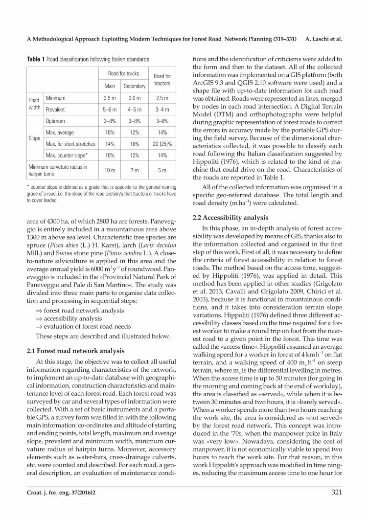
tionsandtheidentificationofcriticismswereaddedtothe form and then to the dataset. All of the collected informationwasimplementedonaGISplatform(bothArcGIS9.3andQGIS2.10softwarewereused)andashapefilewithup-to-dateinformationforeachroadwasobtained.Roadswererepresentedaslines,mergedbynodesineachroadintersection.ADigitalTerrainModel (DTM) and orthophotographswere helpfulduringgraphicrepresentationofforestroadstocorrecttheerrorsinaccuracymadebytheportableGPSdur-ingthefieldsurvey.Becauseofthedimensionalchar-acteristicscollected, itwaspossible toclassifyeachroadfollowingtheItalianclassificationsuggestedbyHippoliti(1976),whichisrelatedtothekindofma-chinethatcoulddriveontheroad.CharacteristicsoftheroadsarereportedinTable1.
All of the collected information was organised in a specificgeo-referreddatabase.Thetotallengthandroaddensity(m ha–1) were calculated.
2.2 Accessibility analysisInthisphase,anin-depthanalysisofforestacces-
sibilitywasdevelopedbymeansofGIS,thanksalsototheinformationcollectedandorganisedinthefirststepofthiswork.Firstofall,itwasnecessarytodefinethecriteriaofforestaccessibilityinrelationtoforestroads.Themethodbasedontheaccesstime,suggest-edbyHippoliti (1976),was applied indetail. Thismethodhasbeenappliedinotherstudies(Grigolatoetal.2013,CavalliandGrigolato2009,Chiricietal.2003),becauseitisfunctionalinmountainouscondi-tions, and it takes into consideration terrain slopevariations.Hippoliti(1976)definedthreedifferentac-cessibilityclassesbasedonthetimerequiredforafor-estworkertomakearoundtriponfootfromthenear-estroadtoagivenpointintheforest.Thistimewascalledthe»accesstime«.Hippolitiassumedanaveragewalkingspeedforaworkerinforestof4km h–1onflatterrain,andawalkingspeedof400ma h–1onsteepterrain,wheremaisthedifferentiallevellinginmetres.Whentheaccesstimeisupto30minutes(forgoinginthemorningandcomingbackattheendofworkday),theareaisclassifiedas»served«,whilewhenitisbe-tween30minutesandtwohours,itis»barelyserved«.Whenaworkerspendsmorethantwohoursreachingtheworksite,theareaisconsideredas»notserved«bytheforestroadnetwork.Thisconceptwasintro-ducedinthe‘70s,whenthemanpowerpriceinItalywas»verylow«.Nowadays,consideringthecostofmanpower,itisnoteconomicallyviabletospendtwohourstoreachtheworksite.Forthatreason,inthisworkHippoliti’sapproachwasmodifiedintimerang-es,reducingthemaximumaccesstimetoonehourfor
Table 1 Road classification following Italian standards
Road for trucks Road for tractorsMain Secondary
Road width
Minimum 3.5 m 3.0 m 2.5 m
Prevalent 5–6 m 4–5 m 3–4 m
Slope
Optimum 3–8% 3–8% 3–8%
Max. average 10% 12% 14%
Max. for short stretches 14% 18% 20 (25)%
Max. counter slope* 10% 12% 14%
Minimum curvature radius in hairpin turns
10 m 7 m 5 m
* counter slope is defined as a grade that is opposite to the general running grade of a road, i.e. the slope of the road section/s that tractors or trucks have to cover loaded

A. Laschi et al. A Methodological Approach Exploiting Modern Techniques for Forest Road Network Planning (319–331)
322 Croat. j. for. eng. 37(2016)2
»barelyserved«areas.Therevisedaccessibilitychar-acteristicsaresummarisedinTable2.Threedifferentmethodswereimplementedinthe
Paneveggioforesttocalculateandgraphicallyrepre-sentthedegreeofaccessibility.Theclassicalmethod,basedonafieldsurveyandmanualrepresentationonmaps,wasimplementedtoidentifythesecondbestapplicationintermsofaccuracyandreliability.Thedescriptionsofeachmethodarereportedbelow.
2.2.1 »Method H« manual approach»Served«and»barelyserved«areasweremanu-
allydrawnstartingfromeachroadbranchandcon-sideringaltitudegaps(100mfor»served«and200mfor»barelyserved«areas).Oncethedraftaccessibilitymapwasmade,afieldsurveypermittedcorrectionofthemapidentifyingnaturalbarriersthatimpedeac-cesstosomeareas,e.g.cliffsanddeepgullies.Finally,theresultsweremanuallyreportedonaGISplatformtoobtainadigitalmap,comparablewiththeresultsofthe other methods.
2.2.2 »Method A« travel timeThiswas thefirstGIS approachapplied in this
studyforaccessibilityestimation.Hippoliti’sdefini-tionforaccessibilitycouldbedescribedtakingintoaccountthetraveltimeortraveldistance.Inthismeth-od,thetraveltimewasconsideredtodeterminetheaccessibilityclassforeachpointintheforestproperty(Chiricietal.2003).Thisoperationrequiredseveralstepsandinformation.ADTMwitharesolutionof5´5mcreatedfromLIDARdata,andtheroadnetworkmappreviouslydeveloped(seeSection2.1)wereusedasstartinginformation.A»CostDistance«toolwasappliedtocalculatetheaccessibilitydegreeofthefor-estsurface.Inparticular,thistoolisaprocedurefordeterminingleastcostpathsacrosscontinuoussur-faces,typicallyusinggridrepresentations(deSmithetal.2015).Inthisstudy,CostDistanceidentifiedthesurface,aroundeachforestroad,withamaximumcostintermsoftimeofwalkingtransferforaforest
worker.Therefore,severalstepsweremadetoobtaina»cost-map«includingtheinformationconcerningthecrossingtimeforeachpixel,whichstrictlydependsontheslopegradient:
Þslopemapcreation,startingfromtheDTM,inrasterformatcontainingtheslopegradientin%foreachpixel,p%
Þdifferentiallevelling(d),coveredforeachpixel,was calculated considering a horizontal distance (d0)of6m(theaverageofthesideofthepixel,5m,andthediagonal,7m),usingtheformula:
% 0differentiallevelling100
p dd
⋅= = (1)
Þ»d«wasreclassifiedwithhighvalue(900m)toexcludeextremeslopes(>100%),thatcouldnotbecrossedbywalking.Forslopeslowerthan10%,afixedvalueof0.6mwasassignedtoob-tainefficientresultsforflatterrains,too
Þconsideringtheclimbingspeedof400ma h–1,correspondingto0.1ma s–1 (tu),arastercontain-inginformationregardingthetimeofpixelcros-singwasmadebythefollowingequation:
–pcu
pixelcrossingtime0.1
d dtt
= = = (2)
Þstartingfromthevectorfileoftheforestroadnetwork,arasterfilerepresentingpresence/ab-sence of roads was created
ÞtheCostDistancetoolwasappliedtodefinethe»served« and »barely served« areas, startingfromtherasterofroadpresenceandthecost-mappreviouslycreated,applyingthetimelim-itsasmaximumcost(15minutesand30minutesfor»served«and»barelyserved«areas,respec-tively)
2.2.3 »Method B« fraction of the maximum distanceInthepreviousmethod,»CostDistance«wasap-
pliedconsideringthetraveltime.Inthiscase,ameth-odthatinterpretstheaccessibilitydefinitionconsider-ingthetraveldistancewasdeveloped.AsexplainedinSection2.2,onflatterrainweconsideredthelineardistancecovered,whileonaslopeweconsideredthechangeofaltitudebetweenthestartingpointattheroadsideandtheworkpointintheforest.ADTMof5´5minresolutionguaranteedthemorphologicalin-formation.TheCostDistanceprocedurewasalsoap-pliedinthiscase,andseveralstepswerenecessary:
Þaslopemap(p%)basedonDTMwascreatedÞtheslopemapwasreclassified,asin»methodA«,toobtainaunique»cost-map«efficientonbothslopeandflatterrain.Therefore,thevalues
Table 2 Accessibility categories based on a revised definition of Hippoliti
AccessibilityAccess time (return trip)
Distance in flat terrain (when slope<10%)
Differential levelling (when
slope³10%)
»Served« Up to 30' Max. 1000 m Max. 100 m
»Barely served«
Between 30' and 60'
Max. 2000 m Max. 200 m
»Not served« More than 60' More than 2000 m More than 200 m

A Methodological Approach Exploiting Modern Techniques for Forest Road Network Planning (319–331) A. Laschi et al.
Croat. j. for. eng. 37(2016)2 323
»10«wereassignedtoallthepixelscharacter-isedbyaslopeupto10%,andthevalue»99999«,toallthepixelswithaslopehigherthan100%
Þa»weight«wasgiventoeachpixel,whichwasdetermined as the ratio between the maximum distance (dmax)onflatterrain(1000m)andthehorizontal distance (Df(p%))correspondingtothe maximum differential levelling (dmax) (»served«=100m,»barelyserved«=200m)onaterrainwiththeslopeofthepixeltakenintoaccount.Finally,theformulasforweightcalcu-lationwerethefollowing:
( )
( )%%
max maxf p
%f p
100weight ,
D dw D
D p⋅
= = = (3)
Þthefinalcost-mapwasobtainedbymultiplyingtheweightvaluebythepixelsize
Þstartingfromthevectorfileoftheforestroadnetwork,arasterfilerepresentingpresence/ab-sence of roads was created
Þstartingfromtheroadraster(presence/absence)andthecost-mappreviouslycreated,applyingthe distance limits as maximum cost (1000 m and2000mfor»served«and»barelyserved«areas,respectively),theCostDistancetoolwasapplied defining the »served« and »barelyserved«areas
2.2.4 »Method C« fixed distance bufferThis isanexpeditiousapproach,whichdidnot
considerHippoliti’sdefinitionofaccessibility.Itwasimplemented tocompareaquickmethodwith theothermodelsdescribed.Itsimplydrewabufferatafixeddistancefromeachroadbranch.Severalexam-plesofthisaccessibilityevaluationhavebeendevel-opedinotherstudies,consideringdifferentdistancesinrelationtothetypeofmachinesandtechniquesap-plied.Somestudiessetauniquelimitvalue,e.g.300mwithoutslopeconsiderations(Bååthetal.2002),and3kmbutlimitedtothefirstslopeclass(max.20%)(López-Rodríguez et al. 2009).Moreover, in otherstudies,differentclasseswithavaryingdistancewereconsidered,comparingbufferswithin150,200and250metresfromtheroad(Penteketal.2008).Inthisstudy,twobufferswereapplied,thefirstinarangeof100 m from the road and the second in a range of 300m.Thefirst corresponds to the »served«area,whichwasidentifiedwiththeoperativedistancegen-erally considered for extraction with tractor andwinch.Thesecondonewasassumedasthe»barelyserved«area,whichcorrespondstotheoperativedis-tancesofalightweightcable-yarder.
Finally,acomparisonbetweenthedifferentmeth-odswasmade.»MethodH«wasconsideredas»truth«tohaveareferenceforcomparison.
2.3 Evaluation of forest road needsThankstothepreviousanalysis,theaccessibility
degreeforallforestmanagementunitswasavailable.Thiswasimportantinformation,butitneededtobeintegratedwithanotheranalysis, inatypicalMCAperspective,toobtainacompletesetofinformationusefulforroadsmanagement.Inparticular,itwasfun-damentaltosupportaccessibilityinformationwiththereal needs of roads for each forest management unit. The »needs of roads« (or »needs of accessibility«)aimedtoidentifytheaccessibilityrequirementsindif-ferentareas,concerningdifferentcharacteristicsoffor-estmanagementunitsand the relatedsilviculturalprescriptionsapplied.Effectively,forestlocatedatanaltitude close to theupper tree line,with low treegrowthandmanagedunderaprotectiveperspective,generallyrequiresaloweraccessibilitylevelthanoth-erslocatedinamorefertilearea,withhighyield,andmanagedunderaproductiveperspective.Inthiscon-text, aGIS-basedmethod for evaluating the forestneedsintermsofaccessibilitywasdeveloped.Itwasassumedthatforestoperationswouldbetheforest-relatedactivitiescharacterisedbythehighestaccessi-bility requirements, comparedwith other servicesprovidedbytheforest,andactivitiescarriedoutinsideit.Therefore,themethodologywasdevelopedconsid-eringfactorsrelatedtoforestproductivity.Ontheba-sisofPaneveggio’sforestmanagementplan,asetofdata was chosen as factors useful for determining the forest-roadneeds.Threecategorieswereidentifiedasmore suitable than the others considering their reli-abilityandtheimpactonthisstudy:growingstock(GS),sitefertilityclass(FC)andproductivepotentialindex (PPI) for high forests. Other factors were dis-cardedforspecificreasons,e.g. theannualvolumeincrement,whichshouldbeagoodindicatorcharac-terisingaforestmanagementunitintermsofproduc-tivecapacity.Inourcase,theincrementinformationpresentedsomeout-of-scalevalues,presumablyat-tributable tomistakes in reporting,whichdid notguaranteeagoodreliabilitylevel.Inparticular,thethreecitedfactorswerechosenbecause:
Þ GSrepresentedareferencepointinashort-termproductivityperspective
Þ FC,whichwasdividedintonineclasses,fromthemost fertile (class»1«) to the least fertile(class»9«),assignedtoeachforestmanagement

A. Laschi et al. A Methodological Approach Exploiting Modern Techniques for Forest Road Network Planning (319–331)
324 Croat. j. for. eng. 37(2016)2
unit.Itwaschosenforrepresentingafixedconditionalongthetimeregardingtheproductioncapacityofeach management unit
Þ PPI,thiswasaclassificationmadebyapoolofexpertsregardingthewholeProvinceofTrento.Followingdifferentparameters,includingthemaintreespecies,hydrogeologicalrisksandenvironmentalsignificance,theyassignedtoforestsub-areasasyntheticvaluerepresentativeoftheirproductivepotential.Thisindexwasdividedintonineclasses,fromthelowestproductivepotential(class»1«)tothehighest(class»9«).Thisfactorwaschosenbecauseitwasrelevantfromalong-termmanagementperspective.
Tocalculatea»roadneedsindex«(RNI),afternormalization,thefactorsweremergedbymeansofaweightedsum.Toassigna»weight«toeachfactor,anAnalyticHierarchyProcess(AHP)wasappliedtotheresultsoflocalforestexpertinterviews.Eachfactorwasnormalised(inarangebetween0and1)followingtheprocessesexplainedbelow:»GrowingStock«(GS):consideringthedistributionofGSvalues,weappliedanexponentialfunctionforGS
valuesupto700m3 ha–1
y–1,withincreasingvaluesfrom0to1;forGSvalueshigherthan700m3 ha–1
y–1,thenor-malisedvalueassignedwasalways1:
2
norm
0.00000198835 0.00280713 0.0093, 0 700
1, 700
GS GS for GSGS
forGS
− + + ≤ ≤= >
(4)
»FertilityClass« (FC):forestmanagementunitdistributioninfertilityclassesshowedareducedfrequencyinthemostfertileclasses.Forthisreason,thisfactorwasnormalisedassigningvalue1tothefirstthreeclasses,andalinearregressionwasappliedfortheclassesfromthefourthtotheninth,withdecreasingvaluesfrom1to0:
norm
1 3 , 36 2
1, 1 3
FC for FC
FCfor FC
− + >
= ≤ ≤
(5)
»ProductivePotentialIndex« (PPI):alinearregressionwasappliedassigningincreasingvaluesfromthelowestpotentialtothehighest,intherange0to1:
norm1 18 8
PPI PPI= − (6)
Sixteenforestexperts,includingforestmanagersandProvincialForestServicemembers,wereinterviewedtocollecttheirpersonalopinionontheimportanceofthethreefactorspreviouslydescribedregardingforestmanage-ment,withspecialattentiononthetopicofforestroads.Inparticular,acompilationofquestions,basedonacomparisonofthethreefactors,wassubmittedtotheexpertsbyapersonalinterview.FollowingAHPconcepts,personalopinionswereimplementedbyExpertChoice®softwaretoobtainanimpartialresultontheimportanceofanalysedfactorsforforestroadmanagement.Thesoftwarecomparedtheanswersgivenbypeopleinterviewedandprovidedthe»weight«valuein%foreachfactor.Finally,onerasterfilewascalculatedforeachfactorinvolvedintheanalysis.TheRNImapwascalculatedbythe
weighted sum between GSnorm,FCnorm and PPInorm:
GS norm FC norm PPI normRNI w GS w FC w PPI= ´ + ´ + ´ (7)
where wGS,wFC and wPPI were the weights obtained for GS,FC and PPI,respectively.TheresultwasamapofthePaneveggioforestinwhicheachpixelwasclassifiedinrelationtoaccessibility
requirements.ThePaneveggioforestwasdividedintofourroadneedsclasses:»Low«:withRNI<0.25,»Medium«:with0.25≤RNI<0.50,»High«:with0.50≤RNI<0.75,»Veryhigh«:withRNI≥0.75.

A Methodological Approach Exploiting Modern Techniques for Forest Road Network Planning (319–331) A. Laschi et al.
Croat. j. for. eng. 37(2016)2 325
3. Results
3.1 Forest road network analysisThefirststepofthisstudycollectedinformation
regardingthestateoftheforestroadnetwork.AshapefilewascreatedandtheroadnetworkisrepresentedinFig.1.Intherelateddatabase,alloftheinformationcollectedandcitedinSection2.1wasrecorded.Thetotal lengthofroadnetworkwithintheforestarea(2803ha)was37.1km,correspondingtoadensityof13.2 m ha–1,whileintheoverallproperty(4366ha)therewere52.4kmofroads,withadensityof12m ha–1. AccordingtotheItalianclassification,themajorityofforestroads(69%oftotal,36km)wereclassifiedas»Roadfortractor«,while25%wereclassifiedas»Sec-ondaryroadfortruck«andonly6%wereincludedinthecategory»Mainroadfortruck«.
3.2 Accessibility analysisThe fourmethodsdescribed inSection2.2were
implementedandcompared.Resultsregardingthesur-facedistributionbetweenthethreeaccessibilityclassesarereportedinTable3.Acomparisonbetween»MethodA«(Fig.2),»MethodB«(Fig.3)and»MethodC«(Fig.4),considering»MethodH«(Fig.5)asreference,was
developedtoevaluatethecorrespondencerate.Inpar-ticular,themapswereoverlappedandcompared,iden-tifyingthepercentageofpixelswiththesameaccessibil-ity class assigned (correspondence) and the others,wherethemodelassigneddifferentclasses.Theresultsshowed that correspondences of 83.1%, 87.2% and51.5%werecalculatedformethodsA,BandC,respec-tively,using»MethodH«asthereference.
3.3 Evaluation of forest road needsThe AHP results defined the values for the
»weights«tobeusedintheRNIcalculation.Inpar-
Fig. 1 Paneveggio forest road network
Table 3 Surface distribution in accessibility classes identified by means of four analysed methods
»Served« »Barely served« »Not served«
»Surface« % ha % ha % ha
»Method H« 56.2 1574 20.0 562 23.8 667
»Method A« 54.7 1534 21.2 594 24.1 675
»Method B« 60.2 1689 21.4 599 18.4 515
»Method C« 26.8 750 34.2 960 39.0 1093

A. Laschi et al. A Methodological Approach Exploiting Modern Techniques for Forest Road Network Planning (319–331)
326 Croat. j. for. eng. 37(2016)2
Fig. 3 Results of »Method B« applied to Paneveggio forest
Fig. 2 Results of »Method A« applied to Paneveggio forest

A Methodological Approach Exploiting Modern Techniques for Forest Road Network Planning (319–331) A. Laschi et al.
Croat. j. for. eng. 37(2016)2 327
ticular, theelaborationofexperts’answersshowedthat themost important factorwas theGS,with aweightof45%,whileweightsof30%and25%weredetermined for FC and PPI,respectively.Thefinalfor-
mulaappliedtoeachforestmanagementunitincal-culating the RNIwas:
norm norm norm0,45 0,30 0,25RNI GS FC PPI= ´ + ´ + ´ (8)
SummarisedinformationonRNI distribution of thetotalsurface,alsoinrelationwiththecurrentac-cessibilityresults,isreportedinTable4.Fig.6givesagraphicalrepresentationoftheRNI
results,distributedfollowingfourclassesestablishedinSection2.3.Overallresultswereinterpretedtoidentifythear-
easintermsofroadaccessibility.Takingintoaccountalloftheresults,twonewroadbrancheswerepro-posed.ThetwohypothesesarereportedinFig.7.
4. DiscussionDuetodifferentanalysesperformed,differenttop-
icswereinvestigatedinthisstudyandusefulinforma-tionwasobtainedtofacilitateandimprovethedeci-sionprocessesrelatedtoforestroadnetworkplanning.Analysisoftheexistingroadnetworkhighlightedthepredominance(69%)offorestroadsonlysuitableforthetransitoftractorandtrailer,while25%wereroadswithbettercharacteristicsintermsofwidth,radiusof
Table 4 Forest area distribution based on RNI. For each RNI class, the distribution of the area in each of the current accessibility classes is shown
Total
At-present accessibility class
»Served«»Barely served«
»Not served«
Road
Nee
ds In
dex
»Low«ha 75.7 0.0 22.4 53.3
% 2.7 0.0 0.8 1.9
»Medium«ha 765.2 185.0 238.3 341.9
% 27.3 6.6 8.5 12.2
»High«ha 1202.5 857.7 274.7 70.1
% 42.9 30.6 9.8 2.5
»Very High«ha 759.6 644.7 64.5 50.4
% 27.1 23.0 2.3 1.8
Fig. 4 Results of »Method C« applied to Paneveggio forest

A. Laschi et al. A Methodological Approach Exploiting Modern Techniques for Forest Road Network Planning (319–331)
328 Croat. j. for. eng. 37(2016)2
Fig. 5 Results of »Method H« applied to Paneveggio forest
Fig. 6. Distribution of forest management units in classes depending on RNI

A Methodological Approach Exploiting Modern Techniques for Forest Road Network Planning (319–331) A. Laschi et al.
Croat. j. for. eng. 37(2016)2 329
curvaturesandslope;only6%ofroadscouldallowthetransitofheavytrucks.Thisinformationshouldsug-gest the enhancement of the main forest roads to im-proveandrationalisewood transportbymeansofheavytrucksinsteadoftractorsandtrailers.Theslopeisacrucialfactorinaccessibilityestimation.Inmoun-tainousareas,theslopeheavilyinfluencestheacces-sibility(CavalliandGrigolato2009)andstronglyaf-fectstheloggingsystemandcostsofforestoperations(Hippoliti1997).Inthisstudy,theaccessibilityanalysisaddedessentialinformationregardingtherationalityinforestroadsdistributionaroundtheforestproperty.Comparingtheappliedmethods,»MethodC«showedtheworstperformance,intermsofcorrespondence,incomparisonwith resultsobtainedby»MethodH«,whichwastakenasthereference.»MethodsA«and»B«hadsimilarresponses;»MethodA«obtainedbet-terresultsthan»MethodB«consideringthegeneralsurfacepercentageallocatedtothethreedifferentcat-egories,whichwereverysimilarinvalueto»MethodH«.Ontheotherhand,»MethodB«showedbetteraccuracy than »MethodA«, considering the corre-spondenceinpixelallocation.Thissimilaritywasex-pected,consideringthesimilarapproachusedinthetwomethods.However,accuracywasconsideredasthemainobjectiveinidentifyingthebestmethodfor
accessibilityestimation,and»MethodB«hadthebet-terperformanceinthissense.Itshoweda»high«rateof»served«managementunitsinPaneveggioforest(about60%ofthetotal)andalimited»notserved«area(18%).Inthiscontext,introducingtheevaluationoftherealneedsofforestroadsindifferentareas,especiallyregarding»barely«and»notserved«areas,couldgiveanaddedvaluetotheroadsplanningprocessaccord-ingtothemulti-criteriaapproach.AsreportedinTable4,»notserved«areasmainlyreferredtoforestmanage-mentunitswitha»low«or»medium«RNI,whileonlyalimitedareawith»high«and»veryhigh«needswas»notserved«.Regarding»barelyserved«managementunits,therewasareasonablerateofforestwith»me-dium«and»high«RNI.Inthiscase,anenhancementoftheroadnetworkshouldimproveaccessibilitycon-ditions,optimisingproductivityinforestoperations.RegardingthethreefactorsanalysedintheAHP,tech-niciansfocusedtheirmaininterestongrowingstock(weight:45%),whichisafactorinfluencingshort-termdecisions.Fertilityclasshadanintermediateweight(30%),thushighlightingtheattentionofforesttechni-ciansalsoonlong-termaspects,whiletheproductivepotentialindex(25%)receivedaquitelowweight.Inpractice,RNIanalysistookintoaccountabalancedmix of information aimed both to short and long-term
Fig. 7 Proposals for two new forest roads

A. Laschi et al. A Methodological Approach Exploiting Modern Techniques for Forest Road Network Planning (319–331)
330 Croat. j. for. eng. 37(2016)2
approachesforforestroadnetworkplanning.How-ever,themethodcouldbeimprovedthroughtheim-plementationofmore,ordifferent,factors;inparticu-lar,theincrementsofvolumeshouldbeconsideredwhenavailabletoobtainarepresentativeparameterrelatedtostandproductivity.Moreover,inRNIanaly-sis,differentsolutionsoralternativescouldbeimple-mentedtooptimisethemethodsdependingonman-agement priorities. In the case of special needs,specificfactorscouldbeintroducedintotheRNI cal-culation formula,enlarging theanalysis to specifictopics.Anexampleofthatwouldbetheuseofindica-torsregardingwildfirerisk,ortourismpointsofinter-est.Inthesecases,theRNIanalysiscouldgiveusefulinformationinadditiontotheordinaryneeds,nor-mallysatisfiedwhentheroadnetworkisfunctionalforforestoperations.
5. ConclusionInthisstudy,amethodologicalapproachaimedto
improveforestroadnetworkplanningwasdevelopedandappliedtoaforestproperty.MCAandAHPcrite-riawereappliedbymeansofGIS,exploitingterres-trialinformationandforestcharacteristics.Thestateandaccessibilityrequirementsinaforestareahavekeyrolesinoptimisingroadnetworkmanagement.Theanalysisdevelopedinthisstudycouldbearealaddedvalueformanagersduringplanning.Inpar-ticular,theexaminedmethodsfacilitateobjectivefor-estroadplanning,whichpermitsoptimisationofre-sourcesandavoidsthebuildingofauselessroadand/oroversizedroadnetwork.Enhancementoftheforestroadnetwork,throughwell-definedimprovements,guaranteesthecorrectmanagementoftheforest,al-lowingalloftheforestservices,suchaswoodproduc-tion, hydrogeological protection, tourism use andhabitatconservation.Inpractice,awell-plannedandwell-realisedroadnetworkmaximisestheefficiencyofallforestactivities,minimisingthecosts,botheco-nomically and environmentally. The approachde-scribedandachievedinthisstudyperfectlyfitinthisperspective,reportingfundamentalinformationuse-fulforsustainablemaintenanceanddevelopmentoftheforestroadnetwork.
6. ReferencesAkbarimehr,M.,Naghdi,R.,2012:Reducingerosionfromforestroadsandskidtrailsbymanagementpractices.Jour-nalofForestScience58(4):165–169.
Avon,C.,Bergès,L.,Dumas,Y.,Dupouey,J.L.,2010:Doestheeffectofforestroadsextendafewmetersormoreinto
theadjacentforest?Astudyonunderstoryplantdiversityinmanaged oak stands. Forest Ecology andManagement259(8):1546–1555.
Bååth,H.,Gällerspång,A.,Hallsby,G.,Lundström,A.,Löf-gren,P.,Nilsson,M.,Ståhl,G.,2002:Remotesensing,fieldsurvey,andlong-termforecasting:Anefficientcombinationforlocalassessmentsofforestfuels.BiomassandBioenergy22(3):145–157.
Çalişkan, E., 2013. Planningof forest roadnetwork andanalysis inmountainousarea.LifeScienceJournal10(2):2456–2465.
Cavalli,R.,Grigolato,S.,2009:Influenceofcharacteristicsandextensionofaforestroadnetworkonthesupplycostofforestwoodchips.JournalofForestResearch15(3):202–209.
Chirici,G.,Marchi,E.,Rossi,V.,Scotti,R.,2003:AnalisievalorizzazionedellaviabilitàforestaletramiteGIS:lafores-tadiBadiaPrataglia(AR).L’ItaliaForestaleeMontana6:460–481.
Dean,D.J.,1997:Findingoptimalroutesfornetworksofhar-vestsiteaccessroadsusingGIS-basedtechniques.CanadianJournalofForestResearch27(1):11–22.
Delgado,J.D.,Arroyo,N.L.,Arévalo,J.R.,Fernández-Pala-cios,J.M.,2007:Edgeeffectsofroadsontemperature,light,canopycover,andcanopyheightinlaurelandpineforests(Tenerife,CanaryIslands).LandscapeandUrbanPlanning81(4):328–340.
Demir,M.,2007:Impacts,managementandfunctionalplan-ning criterion of forest road network system in Turkey.TransportationResearchPartA:PolicyandPractice41(1):56–68.
Ducey,M.,Larson,B.,1999:Afuzzysetapproachtotheprob-lem of sustainability. Forest Ecology and Management115(1):29–40.
Enache,A.,Ciobanu,V.D.,Kühmaier,M.,Stampfer,K.,2013:AnIntegrativeDecisionSupportToolforAssessingForestRoadOptionsinaMountainousRegioninRomania.Croa-tianJournalofForestEngineering34(1):43–60.
Ghajar,I.,Najafi,A.,AliTorabi,S.,Khamehchiyan,M.,Bos-ton,K.,2012:AnAdaptiveNetwork-basedFuzzyInferenceSystemforRockShareEstimationinForestRoadConstruc-tion.CroatianJournalofForestEngineering33(2):313–328.
Grigolato,S.,Pellegrini,M.,Cavalli,R.,2013:Temporalanal-ysisof the traffic loadsonforestroadnetworks. iForest-BiogeosciencesandForestry6(5):255–261.
Gumus,S.,Acar,H.H.,Toksoy,D.,2008:Functionalforestroadnetworkplanningbyconsiderationofenvironmentalimpact assessment forwood harvesting. EnvironmentalMonitoringandAssessment142(1–3):109–116.
Hayati,E.,Majnounian,B.,Abdi,E.,2012:Qualitativeevalu-ationandoptimizationofforestroadnetworktominimizetotalcostsandenvironmentalimpacts.iForest–Biogeosci-encesandForestry5(3):121–125.
A Methodological Approach Exploiting Modern Techniques for Forest Road Network Planning (319–331) A. Laschi et al.
Croat. j. for. eng. 37(2016)2 331
Hippoliti,G.,1997:Appuntidimeccanizzazioneforestale,Firenze:SocietàEditriceFiorentina.
Hippoliti,G.,1976:Sulladeterminazionedellecaratteristichedellareteviableforestale.ItaliaForestaleeMontana–ItalianJournalofForestandMountainEnvironments6:242–255.
Kiss,K.,Malinen,J.,Tokola,T.,2015:ForestroadqualitycontrolusingALSdata.CanadianJournalofForestResearch45(11):1636–1642.
López-Rodríguez,F.,Atanet,C.P.,Blázquez,F.C.,Celma,A.R.,2009:SpatialassessmentofthebioenergypotentialofforestresiduesinthewesternprovinceofSpain,Caceres.BiomassandBioenergy33(10):1358–1366.
Lugo,A.E.,Gucinski,H.,2000:Function,effects,andman-agementofforestroads.ForestEcologyandManagement133(3):249–262.
Miettinen,P.,Hämäläinen,R.P.,1997:Howtobenefitfromdecisionanalysis in environmental life cycle assessment(LCA).EuropeanJournalofOperationalResearch102(2):279–294.
Mohtashami,S.,Bergkvist,I.,2012:AGISApproachtoAna-lyzingOff-RoadTransportation:aCaseStudyinSweden.CroatianJournalofForestEngineering33(2):275–284.
Najafi,A.,Richards,E.W.,2013:DesigningaForestRoadNetworkUsingMixedIntegerProgramming.CroatianJour-nalofForestEngineering34(1):17–30.
Pellegrini,M.,Grigolato,S.,Cavalli,R.,2013:SpatialMulti-CriteriaDecisionProcesstoDefineMaintenancePrioritiesofForestRoadNetwork:anApplicationintheItalianAlpineRegion.CroatianJournalofForestEngineering34(1):31–42.
Pentek, T., Pičman, D., Nevečerel, H., Lepoglavec, K.,Poršinsky,T.,2008:Roadnetworkqualityofthemanage-mentunitPiščetak–GISanalysis.InProceedingsofthe3rd international scientific conferenceFORTECHENVI 2008,45–53.
Saaty,T.L.,1980:Theanalytichierarchyprocess:planning,prioritysetting,resourcesallocation.NewYork:McGraw.
Sacchelli,S.,DeMeo,I.,Paletto,A.,2013:Bioenergyproduc-tionandforestmultifunctionality:Atrade-offanalysisusingmultiscaleGISmodelinacasestudyinItaly.AppliedEn-ergy104:10–20.
Samani,K.,Hosseiny,S.,2010:PlanningroadnetworkinmountainforestsusingGISandAnalyticHierarchicalPro-cess(AHP).CaspianJournalofenvironmentalsciences8(2):151–162.
deSmith,M.J.,Goodchild,M.F.,Longley,P.A.,2007:Geospa-tialAnalysis.Acomprehensiveguidetoprinciples. tech-niquesandsoftwaretools.Leicester,UK:Matador,Trouba-dorPublishingLtd.
Trombulak,S.C.,Frissell,C.A.,2012:ReviewofEcologicalEffectsofRoadsonTerrestrialandAquaticCommunitiesandofAquaticEcologicalEffectsofRoadsonTerrestrialCommnunities14(1):18–30.
Vacik,H.,Lexer,M.J.,2014:Past,currentandfuturedriversforthedevelopmentofdecisionsupportsystemsinforestmanagement.ScandinavianJournalofForestResearch29(1):2–19.
ZekiBaskent,E.,Keles,S.,2005:Spatialforestplanning:Areview.EcologicalModelling188(2–4):145–173.
Received:February1,2016Accepted:April4,2016
Authors’address:
AndreaLaschi,PhD.*e-mail:[email protected],PhD.e-mail:[email protected]òBrachettiMontorselli,PhD.e-mail:[email protected],PhD.e-mail:[email protected]–DepartmentofAgricultural, FoodandForestrySystemsViaSanBonaventura1350145FlorenceITALY
*Correspondingauthor