methodological proposals for documenting and … · methodological proposals for documenting and...
TRANSCRIPT
Methodological Proposals for
Documenting and Searching
for Missing Persons in Colombia
©2010, This publication was carried out with the support of United States Institute for Peace. All statements herein are solely the responsibility of EQUITAS.

Equ
itas
© 2
010
3
Page
5. Introduction
9. Rivers
Using computer simulation as a tool for
the search of missing persons: tracking
object drift trajectories in the Magdalena
River (Colombia)
Ana Carolina Guatame, MSc
19. Legal Cemeteries
Using Cemetery Information in the Search
for the Disappeared: Lessons from a Pilot
Study in Rionegro, Antioquia.
Tamy Guberek, Daniel Guzmán,
Beatriz Vejarano
29. Construction debris dumps
Archaeological desk based assesment
for the search of missing persons in the
Escombrera construction debris dump
(Medellín, Colombia)
Kevin Lane, PhD.
39. Clandestine Burials
Remote sensing analysis proposal for
the location of clandestine cemeteries
next to the Casanare River in Colombia
Luz Adriana Guatame
Methodological proposals for documenting and searching for missing persons
Contents

Equ
itas
© 2
010
5
Rivers
MethodoLogICaL pRoposaLs
foR the doCuMentatIon
and seaRCh foR MIssIng peRsons
EQUITAS, as a victim-centered, evidence-based
scientific and humanitarian organization,
provides independent scientific contributions and
psychosocial assistance to families of victims of
crimes committed in the context of serious, mass
or systematic human rights violations and armed
conflicts. We have invested most of our energy in
the last 5 years in developing contributions related
to the search, identification and forensic analysis
of victims of forced disappearance in Colombia. As
we develop our work, we have identified structural
methodological and scientific issues , which evidence
a complex scenario of a long, changing on-going
conflict, combined with transitional peace processes
and a complex state bureaucracy.
Our approach to these challenges has been to
develop tools and scientific contributions, which we
believe will improve official as well as private forensic
practices, guide public policies and raise public
awareness. With this emphasis, we have generated
interdisciplinary questions and, together with profes-
sionals and groups, made initial proposals in order to
understand the magnitude of the crime and the chal-
lenges that surround search processes in the country.
Who Is BuRIed WheRe?
Forensic identification is based on matching
information from a missing person with human
remains found. Therefore, it is fundamental to
understand the universe of people that have
disappeared in conflict and which must be found.
Information on who and how many people are missing
will lead to methodologically adequate, sustainable
and planned technical processes such as: search and
recovery in different scenarios, human identification,
forensic analysis and judicial investigation.
Introduction
Equ
itas
© 2
010
6
In its casework, EQUITAS has been scientifically
challenged to make contributions to search processes
in scenarios such as large haciendas or farms, next
to river flood areas, non-identified bodies’ sections in
legal cemeteries, and even cases in which the bodies
were allegedly thrown into rivers. These scenarios
constantly remind us of the intention of perpetra-
tors of the crime of forced disappearance to leave no
trace. The victim was not killed and left in public, but
rather, disappeared. Therefore, answering the ques-
tion of who is buried where?, is key when it comes to
bridging that gap between non-identified remains
that are found and reports of missing persons who
still have not been found.
speCIfIC Context ChaLLenges
There are additional factors that challenge
interdisciplinary work around this key question.
The implementation of the 2005 Justice and Peace
Law as a transitional peace process, has greatly
impacted the search for missing persons in Colombia.
Issues that in the past did not receive much interest,
became more visible and revealed more widely
the drama behind stories of missing Colombians.
Based on information provided by demobilized
paramilitaries1, over 3,000 bodies have been recovered
to date in mass exhumations carried out nationwide
by different teams from the Prosecutor General’s
Office, and other CSI teams from the Police (DIJIN),
and the Security Administrative Department (DAS).
As bodies are being recovered, families have begun
to report their missing relatives to state entities, to
the point that by 2009, the official figure reports over
27.0002 cases of disappearances.
1. ConsolidatedfigurebyJanuary6,2010accordingtotheJustice
andPeaceUnit.Seehttp://www.fiscalia.gov.co/justiciapaz/EXH/
EXHUMACIONES.htm
2. CasesreportedintheSIRDECNationalDisappeared
RegisterSystem,inapproximatelythelast20years.See
page38,DocumentoConpes3590,ConsolitatingSearchand
IdentificationMechanismsofMissingPersonsinColombia,
NationalPlanningDepartment,June2009.
Important efforts have been carried out on behalf
of state entities to coordinate their work through the
National Search Commission, trying to implement
the National Search Plan approved in 2007, focusing
efforts in the National Register of Disappeared Persons
(SIRDEC), and creating public policy tools, such as
Policy Paper CONPES 3590 from June 2009. However, the
magnitude of the task ahead appears overwhelming:
The percentage of identified bodies over non-identified
bodies remains below a third, state entities responsible
for these processes lack complete information of
those missing, further disappearances continue to
occur, paramilitary testimonies are incomplete, and
consistent evidence has involved dozens of members
of the Armed Forces in alleged extrajudicial executions
under the “false positives” scandal3.
All these challenges reveal the difficult task of find-
ing and identifying missing people in Colombia – a task
that will be carried out for decades to come. Committed
to it, EQUITAS, BENETECH and other experts, are work-
ing together to better document who is buried where,
in order to support the search for those disappeared.
This publication explores four different scenarios that
have not been systematically studied in Colombia: legal
cemeteries, rivers, clandestine burials in flood areas,
and construction middens or debris dumps. The articles
propose interdisciplinary methodologies, with the pur-
pose of offering alternative lines of evidence that
3. ProfessorPhilipAlston,UNSpecialRapporteuronextrajudicial
executions,inhismissiontoColombiainJune2009,reports
closeto1800cases,andexplainsinhisreporthowthisterm
and evidence of some of the cases he studied, refer to a
sort of technical aura to describe a practice which is better
characterizedascold-blooded,premeditatedmurderof
innocentciviliansforprofit.“Thephenomenoniswellknown.
Thevictimisluredunderfalsepretensesbya“recruiter”toa
remotelocation.There,theindividualiskilledsoonafterarrival
bymembersofthemilitary.Thesceneisthenmanipulated
to make it appear as if the individual was legitimately killed
incombat.Thevictimiscommonlyphotographedwearinga
guerrilla uniform, and holding a gun or grenade. Victims are
often buried anonymously in communal graves, and the killers
arerewardedfortheresultstheyhaveachievedinthefight
againsttheguerillas.”
Equ
itas
© 2
010
7
do not depend on human testimony, but can be cross-
referenced with it, in order to maximize search efforts
in the field. We believe good scientific practice is key
to sustainable scientific work in Colombia, and will
ease the pressure already stemming from political and
security issues of working in on-going conflict. In the
longer run, it is only this way that Colombia will be able
to understand its past, and build on it a better future.
aBout authoRs and CoLLaBoRatoRs
Our permanent team member Ana Carolina Guatame,
MSc., forensic anthropologist, presents a proposal
based on her masters’ degree dissertation. She uses
computer simulation as a reliable tool for predicting
possible travel trajectories that an object similar to
the human body may have, and the travel times it
could take to reach specific locations in a river. This
type of work can provide key insights to prioritize
search areas in meanders, riverbeds and flood
areas in cases where there are testimonies that
people were thrown into rivers. Archaeology in dry
seasons, dredging material archaeology, as well as
documenting areas close to rivers where inhabitants
have recovered floating bodies and disposed them
in improvised or legal cemeteries, will be the future
steps derived from the application of this tool.
Benetech, is a partner organization to EQUITAS.
Its Human Rights Data Analysis Group has over
17 years of experience applying rigorous scientific
analysis to data on human rights violations, and
has worked with nine Truth and Reconciliation
Commissions, U.N. missions and official human rights
bodies, and international criminal tribunals. In an
effort to support the search for the disappeared in
Colombia, Benetech has used statistical methods
and explored the utility of incorporating indirect,
non-testimonial data into quantitative analyses. A
first effort was in the region of Casanare, where they
used a statistical method called “Multiple Systems
Estimation” to account for unreported missing
victims - those missing not only from society and their
families but also from any record of disappearance.4
In its 2007 study, Missing People in Casanare,
Benetech estimated that between 30 and 40 percent
of missing people in Casanare remained unreported
between 1986 to 2007. 5
EQUITAS and HRDAG detected the need to
explore the usefulness of data from non-identified
bodies in cemeteries, as a source of information for
searching for missing persons. By analyzing the par-
ish book of deaths, the gravediggers’ notebook and
a census of the gravestones at a legal cemetery, the
pilot study revealed interesting temporal patterns of
the identified and non-identified dead. Institutions
involved in identification efforts may compare these
cemetery patterns with reports of conflict-related
disappearances and accounts of combats in the area
in order to determine more clearly whether certain
disappearances could match individual remains in a
cemetery. Improved documentation practices on be-
half of cemetery administrators and analysis of other
existing sources, will lead to more effective search
and identification processes of the NN in the cem-
etery, and to understanding the patterns of conflict
and most likely perpetrators.
We have invited Kevin Lane Phd Archaeologist
and Research Fellow at the Archaeology Department,
University of Manchester UK, to propose a desk-
based assessment for an extremely difficult
recovery scenario: a construction midden or debris
dump. Applying complete survey and excavation
methodologies to these large-scale scenarios is
effectively impossible. However, this assessment
4. Multiple systems estimation (MSE) is a technique that uses
two or more separately collected but incomplete lists of a
populationtoestimatethetotalpopulationsize.HRDAGuses
the multiple systems estimation technique in human rights
cases to project the total number of violations, including those
that were never documented.
5. Guzmán,Daniel,TamyGuberek,AmeliaHoover,andPatrickBall.
2007.“Missing People in Casanare.”Benetech.Alsoavailablein
Spanish-“Los Desaparecidos de Casanare.”
Equ
itas
© 2
010
8
proposes to verify reliable evidence of the state
and geography of the dump during the main period
of activity associated to the time of deposition of
bodies. For example, aerial or satellite imagery,
could help to establish a depth and intervention area
in the dump, which will maximize search efforts.
Geo-referenced trenches, coffer-dam excavation
and midden removal through JBC excavators are
part of an archaeological activity plan that seeks to
reasonably invest efforts to search for the remains of
missing persons in the dump.
Geologist and researcher on geological
applications of teleobservation at Ingeominas,
Colombia, Adriana Guatame, explores remote analysis
in order to identify terrain modification patterns as
potential indicators of clandestine burial sites. This
pilot study finds that these sites clearly tend to be
located in areas of river marginal activity, particularly
in flood plains. Understanding rivers as a changing
landscape and observing their evolution through
time can be extremely useful when interpreting
testimonies of various actors on the location of
burials. A geostatistic perspective using accurate and
systematic information related to fluvial activity,
land use, soil type, rain and flow patterns, will further
develop tele-detection studies as a key element to
plan regional search efforts with the aid of specific
geophysical tools according to terrain characteristics.
We hope these proposals set a baseline for an
interdisciplinary approach around the question of
Who is buried where?, that will result in successful
search, investigation and human identification
results of deaths related to conflict. Open
discussion, future tests, and most importantly,
accurate documentation of all experiences, will
be fundamental in developing new solutions for
the humanitarian and scientific task before us:
contributing to return the remains of missing persons
to their loved ones, as well as offering evidence of the
circumstances in which they died, that may be used in
justice and reparation processes.
Finally, we wish to thank the United States
Institute for Peace for supporting this work as a
contribution to building knowledge and creating
innovative tools for peacebuilding.
Drisha Fernandes,
Research and Development, EQUITAS
Equ
itas
© 2
010
9
Methodological proposals for documenting and searching for missing persons
Rivers
Using computer
simulation as a tool
for the search of
missing persons:
tracking object drift
trajectories in the
Magdalena River
(Colombia)
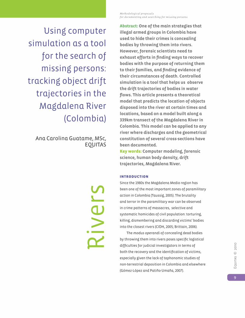
Ana Carolina Guatame, MSc, EQUITAS
abstract: One of the main strategies that
illegal armed groups in Colombia have
used to hide their crimes is concealing
bodies by throwing them into rivers.
However, forensic scientists need to
exhaust efforts in finding ways to recover
bodies with the purpose of returning them
to their families, and finding evidence of
their circumstances of death. Controlled
simulation is a tool that helps us observe
the drift trajectories of bodies in water
flows. This article presents a theoretical
model that predicts the location of objects
disposed into the river at certain times and
locations, based on a model built along a
339km transect of the Magdalena River in
Colombia. This model can be applied to any
river where discharges and the geometrical
constitution of several cross-sections have
been documented.
Key words: Computer modeling, forensic
science, human body density, drift
trajectories, Magdalena River.
IntRoduCtIon
Since the 1980s the Magdalena Medio region has
been one of the most important zones of paramilitary
action in Colombia (Taussig, 2005). The brutality
and terror in the paramilitary war can be observed
in crime patterns of massacres, selective and
systematic homicides of civil population: torturing,
killing, dismembering and discarding victims’ bodies
into the closest rivers (CIDH, 2005; Brittain, 2006).
The modus operandi of concealing dead bodies
by throwing them into rivers poses specific logistical
difficulties for judicial investigators in terms of
both the recovery and the identification of victims,
especially given the lack of taphonomic studies of
non-terrestrial deposition in Colombia and elsewhere
(Gómez-López and Patiño-Umaña, 2007).
Riv
ers

Equ
itas
© 2
010
10
Using computer simulation as a tool for the search of missing persons: tracking
object drift trajectories in the Magdalena River (Colombia)
Rivers
Both the unique legal and social context of the
missing in Colombia, challenge forensic sciences to
develop scientific methods that will improve human
remains search techniques, especially in particularly
difficult locations, such as rivers.
The use of prediction models to infer drift
trajectories and establish patterns in order to
describe likely scenarios in which victims can be
found, becomes necessary considering the highly
complex nature of the dynamics of fluvial behavior.
However, the development of these tools depends on
the amount and quality of information that can be
used to make predictions, especially those regarding
the behavior of rivers.
In studying bodies disposed in moving waters,
many problems arise due to decomposition, as well
as transportation, disarticulation and dispersion. In
such cases, computer modeling has proven to be an
invaluable tool leading towards the understanding of
former cases and the prediction of the flow pattern of
bodies (Ebessmeyer and Haglund, 1994; Carniel et al.,
2002).
MateRIaLs and Methods
The trajectory of objects was modeled in a 339km
section of the Magdalena River between the Puente
de la Variante (department of Cundinamarca) and
the city of Puerto Berrío (department of Antioquia)
(Figure 1). The modeling process considered buoyant,
hydrostatic and dynamic forces, calculated by using
velocity, discharge, and depth, computed in a nu-
merical hydraulic model developed by Camacho and
Lees (1998). Results and information from previous
research studies were incorporated into the modeling
framework to represent the trajectory of bodies with
different densities and specific gravities.
Figure 1 Magdalena River Section Puente de la Variante – Puerto Berrío
Ma
p p
rovi
ded
by
Pro
cálc
ulo
Pro
sis
S.A
. Co
lom
bia
Equ
itas
© 2
010
11
Methodological proposals for documenting and searching for missing persons
Rivers
The theoretical (mathematical) model was cali-
brated by means of physical experiments carried out
in the Teusacá and Magdalena rivers. These experi-
ments provided detailed hydraulic data, observations
on the orientation of the object, flood effects on the
object’s movement, and on travel time according to
each object for comparison. These elements offer
an accurate representation of the real flow pattern
of the river section as well as the simulation of the
object’s movement and distance traveled.
After calibrating the computer model, 972 tests
were performed to observe the predicted movement
of objects in the Magdalena River. The first set of
experiments (n=486) was implemented for the experi-
mental stretch Puerte de la Variante – Girardot’s Gas
Pipe (10.7kms), called RM1 for the purposes of this
study, and the second one (n=486) was carried out for
the complete section of study Puente de la Variante –
Puerto Berrío (339kms), called RM2.
CoMputeR ModeL opeRatIon
The model takes into account 5 external and 4
intrinsic variables (Table 1). These variables define
the environmental conditions in which the body will
move, and the drift pattern it is likely to display. The
object’s movement pattern (model output) consists of
five features: mean travel time, minimum travel time,
velocity, flotation depth, and mass loss.
Table 1 Variables and values used as data entry on the computer model
Variable Model
predefined
range
Used
values
Description
River Q Undefined* 444.7
1118.9
2170.9
Lowest Magdalena River daily discharge reported to occur 95% of
the year at Nariño station (Universidad de los Andes Acuagyr, 2005)
Middle Magdalena River daily discharge reported to occur 50% of
the year at Nariño station (Universidad de los Andes Acuagyr, 2005)
Highest Magdalena River daily discharge reported to occur 5% of the
year at Nariño station (Universidad de los Andes Acuagyr, 2005)
Water
temp ºC
Undefined 22
26
30
Lowest water temp. considered for the range 20—30ºC
Middle water temp. considered for the range 20—30ºC
Highest water temp. considered for the range 20—30ºC
External Init.
position
0—1 0.3
0.6
0.9
Object initial position, as a fraction of the total width from the
K
Degrad
Proportional
to water
temperature
0.03
0.04
0.05
Mass loss ratio calculated for a human body taking into account the
degradation of organic material in water at 22ºC
Mass degradation ratio calculated at 26ºC
Mass degradation ratio calculated at 30ºC
Trapping
factor
(Trap. F)
0—2 0.5
1
1.5
Body external trapping ratio, where 0=free motion, 2=highly trapped.
Object
Mass
(Kg)
Undefined 50
75
100
Lowest body weight
Middle body weight
Highest body weight
* An “Undefined” range means any value can be used according to the specific conditions of each case.
Ma
p p
rovi
ded
by
Pro
cálc
ulo
Pro
sis
S.A
. Co
lom
bia
Equ
itas
© 2
010
12
Using computer simulation as a tool for the search of missing persons: tracking
object drift trajectories in the Magdalena River (Colombia)
Rivers
Variable Model
predefined
range
Used
values
Description
Density
(g/cm3)
Proportional
to body
length and
diameter (V)
0.9
1.06
Low density
High density (Human density for young male adults according to
Krzywicki and Chinn, 1967)
Body Trunk
diameter
(m)
Proportional
to body
weight
0.21
0.24
0.27
Waist diameter for male adults based on Miyatake (2005) measure-
ments of waist circunference
Length Maximum
feasible
body length
proportional
to body
1.5
1.65
1.8
Body lenght calibrated from physical experimentation
Body lenght calculated as the proportion of calibrated body length
to body weight
Table 1. Variables and values used as data entry on the computer model (continuation)
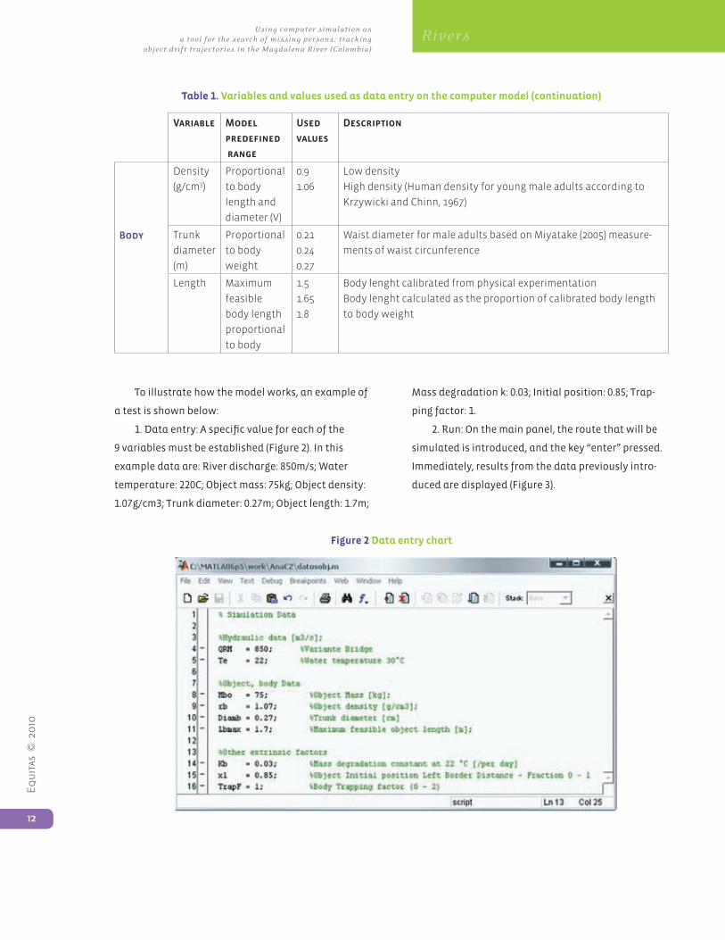
To illustrate how the model works, an example of
a test is shown below:
1. Data entry: A specific value for each of the
9 variables must be established (Figure 2). In this
example data are: River discharge: 850m/s; Water
temperature: 220C; Object mass: 75kg; Object density:
1.07g/cm3; Trunk diameter: 0.27m; Object length: 1.7m;
Mass degradation k: 0.03; Initial position: 0.85; Trap-
ping factor: 1.
2. Run: On the main panel, the route that will be
simulated is introduced, and the key “enter” pressed.
Immediately, results from the data previously intro-
duced are displayed (Figure 3).
Figure 2 Data entry chart
Equ
itas
© 2
010
13
Methodological proposals for documenting and searching for missing persons
Rivers
Figure 3 Output interface
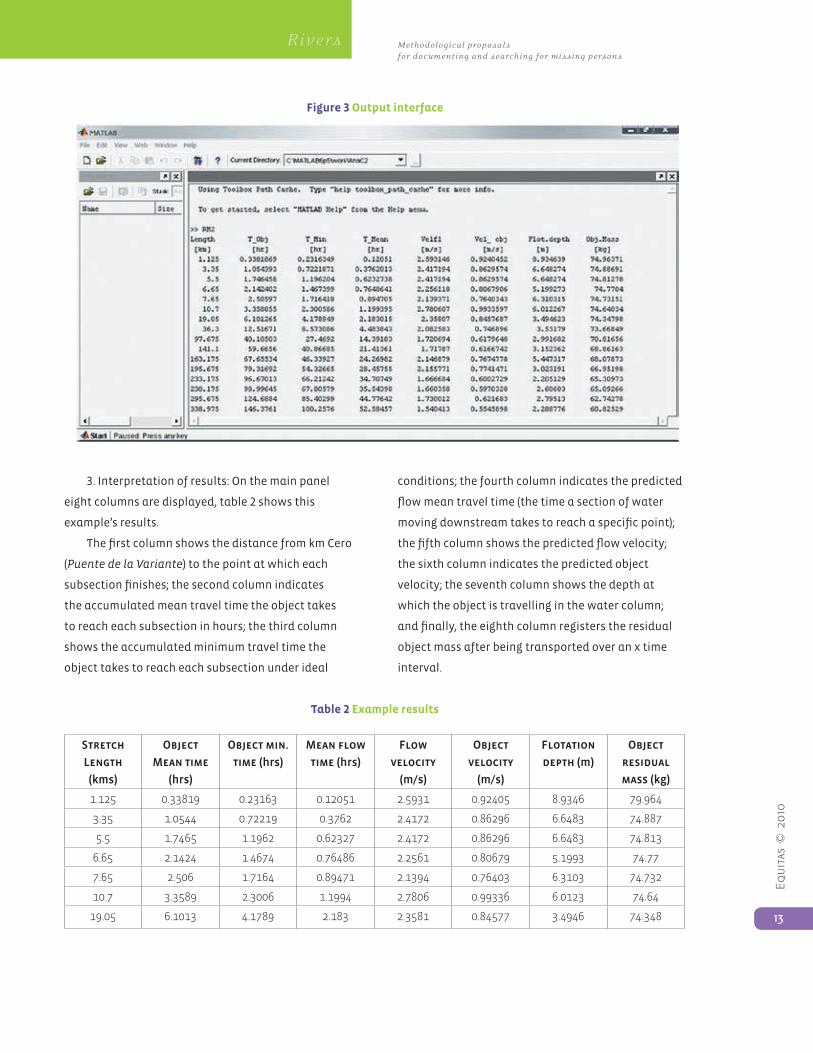
3. Interpretation of results: On the main panel
eight columns are displayed, table 2 shows this
example’s results.
The first column shows the distance from km Cero
(Puente de la Variante) to the point at which each
subsection finishes; the second column indicates
the accumulated mean travel time the object takes
to reach each subsection in hours; the third column
shows the accumulated minimum travel time the
object takes to reach each subsection under ideal
conditions; the fourth column indicates the predicted
flow mean travel time (the time a section of water
moving downstream takes to reach a specific point);
the fifth column shows the predicted flow velocity;
the sixth column indicates the predicted object
velocity; the seventh column shows the depth at
which the object is travelling in the water column;
and finally, the eighth column registers the residual
object mass after being transported over an x time
interval.
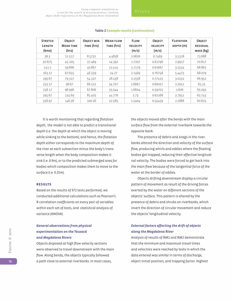
Table 2 Example results
Stretch
Length
(kms)
Object
Mean time
(hrs)
Object min.
time (hrs)
Mean flow
time (hrs)
Flow
velocity
(m/s)
Object
velocity
(m/s)
Flotation
depth (m)
Object
residual
mass (kg)
1.125 0.33819 0.23163 0.12051 2.5931 0.92405 8.9346 79.964
3.35 1.0544 0.72219 0.3762 2.4172 0.86296 6.6483 74.887
5.5 1.7465 1.1962 0.62327 2.4172 0.86296 6.6483 74.813
6.65 2.1424 1.4674 0.76486 2.2561 0.80679 5.1993 74.77
7.65 2.506 1.7164 0.89471 2.1394 0.76403 6.3103 74.732
10.7 3.3589 2.3006 1.1994 2.7806 0.99336 6.0123 74.64
19.05 6.1013 4.1789 2.183 2.3581 0.84577 3.4946 74.348
Equ
itas
© 2
010
14
Using computer simulation as a tool for the search of missing persons: tracking
object drift trajectories in the Magdalena River (Colombia)
Rivers
Stretch
Length
(kms)
Object
Mean time
(hrs)
Object min.
time (hrs)
Mean flow
time (hrs)
Flow
velocity
(m/s)
Object
velocity
(m/s)
Flotation
depth (m)
Object
residual
mass (kg)
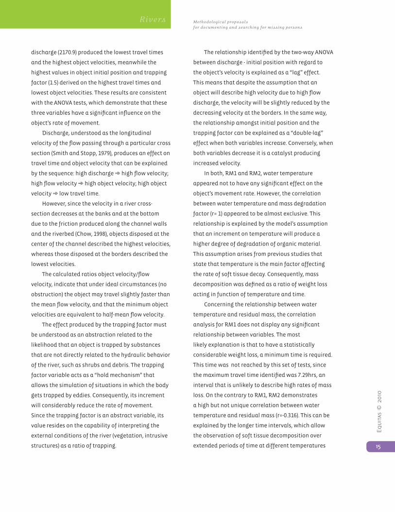
36.3 12.517 8.5731 4.4838 2.0826 0.7469 3.5318 73.688
97.675 45.105 27.469 14.392 1.7207 0.61796 2.9917 70.817
141.1 59.666 40.867 21.414 1.7179 0.61667 3.1524 68.862
163.17 67.655 46.339 24.27 2.1469 0.76748 5.4473 68.079
195.67 79.317 54.327 28.458 2.1558 0.77415 3.0232 66.952
233.17 96.67 66.212 34.707 1.6667 0.60027 2.2051 65.31
238.17 98.996 67.806 35.544 1.6604 0.59703 2.606 65.093
295.67 124.69 85.403 44.776 1.73 0.62168 2.7951 62.743
338.97 146.38 100.26 52.585 1.5404 0.55459 2.2888 60.825
Table 2 Example results (continuation)
It is worth mentioning that regarding flotation
depth, the model is not able to predict a transitional
depth (i.e. the depth at which the object is moving
while sinking to the bottom), and hence, the flotation
depth either corresponds to the maximum depth of
the river at each subsection minus the body’s trans-
verse length when the body composition makes it
sink (i.e. 8.9m), or to the predicted submerged area for
bodies which composition makes them to move to the
surface (i.e. 0.25m).
ResuLts
Based on the results of 972 tests performed, we
conducted additional calculations such as Pearson’s
R correlation coefficients on every pair of variables
within each set of tests, and statistical analysis of
variance (ANOVA).
General observations from physical
experimentation on the Teusacá
and Magdalena Rivers
Objects disposed at high flow velocity sections
were observed to travel downstream with the main
flow. Along bends, the objects typically followed
a path close to external riverbanks. In most cases,
the objects moved after the bends with the main
surface flow from the external riverbank towards the
opposite bank.
The presence of debris and snags in the river-
banks altered the direction and velocity of the surface
flow, producing whirls and eddies where the floating
bodies got trapped, reducing their effective longitudi-
nal velocity. The bodies were forced to get back into
the main flow because of the tangential force of the
water at the border of eddies.
Objects drifting downstream display a circular
pattern of movement as result of the driving forces
exerted by the water on different sections of the
objects’ surface. This pattern is altered by the
presence of debris and shrubs on riverbanks, which
invert the direction of circular movement and reduce
the objects’ longitudinal velocity.
External factors affecting the drift of objects
along the Magdalena River
Analysis of results of RM1 and RM2 demonstrate
that the minimum and maximum travel times
and velocities were reached by tests in which the
data entered was similar in terms of discharge,
object initial position, and trapping factor. Highest
Equ
itas
© 2
010
15
Methodological proposals for documenting and searching for missing persons
Rivers
discharge (2170.9) produced the lowest travel times
and the highest object velocities, meanwhile the
highest values in object initial position and trapping
factor (1.5) derived on the highest travel times and
lowest object velocities. These results are consistent
with the ANOVA tests, which demonstrate that these
three variables have a significant influence on the
object’s rate of movement.
Discharge, understood as the longitudinal
velocity of the flow passing through a particular cross
section (Smith and Stopp, 1979), produces an effect on
travel time and object velocity that can be explained
by the sequence: high discharge ➾ high flow velocity;
high flow velocity ➾ high object velocity; high object
velocity ➾ low travel time.
However, since the velocity in a river cross-
section decreases at the banks and at the bottom
due to the friction produced along the channel walls
and the riverbed (Chow, 1998), objects disposed at the
center of the channel described the highest velocities,
whereas those disposed at the borders described the
lowest velocities.
The calculated ratios object velocity/flow
velocity, indicate that under ideal circumstances (no
obstruction) the object may travel slightly faster than
the mean flow velocity, and that the minimum object
velocities are equivalent to half-mean flow velocity.
The effect produced by the trapping factor must
be understood as an abstraction related to the
likelihood that an object is trapped by substances
that are not directly related to the hydraulic behavior
of the river, such as shrubs and debris. The trapping
factor variable acts as a “hold mechanism” that
allows the simulation of situations in which the body
gets trapped by eddies. Consequently, its increment
will considerably reduce the rate of movement.
Since the trapping factor is an abstract variable, its
value resides on the capability of interpreting the
external conditions of the river (vegetation, intrusive
structures) as a ratio of trapping.
The relationship identified by the two-way ANOVA
between discharge - initial position with regard to
the object’s velocity is explained as a “lag” effect.
This means that despite the assumption that an
object will describe high velocity due to high flow
discharge, the velocity will be slightly reduced by the
decreasing velocity at the borders. In the same way,
the relationship amongst initial position and the
trapping factor can be explained as a “double-lag”
effect when both variables increase. Conversely, when
both variables decrease it is a catalyst producing
increased velocity.
In both, RM1 and RM2, water temperature
appeared not to have any significant effect on the
object’s movement rate. However, the correlation
between water temperature and mass degradation
factor (r= 1) appeared to be almost exclusive. This
relationship is explained by the model’s assumption
that an increment on temperature will produce a
higher degree of degradation of organic material.
This assumption arises from previous studies that
state that temperature is the main factor affecting
the rate of soft tissue decay. Consequently, mass
decomposition was defined as a ratio of weight loss
acting in function of temperature and time.
Concerning the relationship between water
temperature and residual mass, the correlation
analysis for RM1 does not display any significant
relationship between variables. The most
likely explanation is that to have a statistically
considerable weight loss, a minimum time is required.
This time was not reached by this set of tests, since
the maximum travel time identified was 7.29hrs, an
interval that is unlikely to describe high rates of mass
loss. On the contrary to RM1, RM2 demonstrates
a high but not unique correlation between water
temperature and residual mass (r=-0.316). This can be
explained by the longer time intervals, which allow
the observation of soft tissue decomposition over
extended periods of time at different temperatures
Equ
itas
© 2
010
16
Using computer simulation as a tool for the search of missing persons: tracking
object drift trajectories in the Magdalena River (Colombia)
Rivers
(i.e. T232 and T444 yielded the same travel times but
their residual masses significantly differed because
T232 was run at 220C while T444 was run at 300C).
Flotation effects on the object’s movement rate
The model does not consider flotation depth as a
pre-defined variable. However, it is calculated from
mathematical reasoning related to buoyancy and
hydrostatic forces (i.e. specific gravity) that act once
a body is deposited into a fluid. The one-way ANOVA
revealed a very significant effect of flotation depth on
the object’s movement rate (p=0.000). It is consistent
with the theory that object travel times and velocities
depend, among others, on the vertical coordinates
that indicate the position at which an object moves
downstream.
There is an actual difference on travel times and
velocities as a result of changes in flotation depth;
however, they do not meet the decreasing scale with
depths found in trapezoidal channels. This indicates
that the channel displays an irregular geometric
configuration that makes velocities irregularly
distributed. However, given that the model structure
relies on available information of the geometric
configuration of the river at spaced cross-sections,
the model is capable of identifying velocities at each
point of the vertical column, allowing the prediction
of the object’s velocity at a calculated flotation
depth.
In addition to the irregular distribution of flow
velocities, the low gravity force displayed by a
buoyant object can explain high object velocities
close to the water surface. This kind of drift only has
a longitudinal direction that reduces the resistance
force, and then increases the object’s velocity.
Examining the Pearson’s correlation coefficients,
it can be stated that in spite of the importance
given by flotation depth on the object’s travel time
and velocity, variables such as initial position and
trapping factor have higher influence on the rate of
movement. Thus, these variables cannot be single-
handled, but their influence must be analyzed as a
coalescence of interrelations in which the impact is to
some extent predictable.
It is worth mentioning that the calculated
flotation depth remains the same along the whole
route followed by the object, and hence, it does not
describe the movement of the body in the water
column. According to Cotton et al. (1987) a human
body disposed in water initially sinks, and may
resurface depending on water temperature. With
fairly warm water temperatures, a body can be
expected to surface within a few days, whereas with
cold or near-freezing water temperatures, resurfacing
of the body can be delayed for several weeks to
several months.
However, because the model is not able to
simulate these changes in flotation depth, the
significance of the relationship between flotation
depth and water temperature cannot be established
at this time.
Intrinsic factors affecting
the object’s rate of movement
A preliminary hypothesis based on Donoghue and
Minniguerode (1977) and Boaz and Behrensmeyer
(1976), stated that body density is correlated with
the average rate of movement. The one-way ANOVA
proved this hypothesis yielding a significance of
p=0.014 per object mean travel time and p=0.000
per object velocity. Also, the strong proportional
relationship between density and flotation depth
(r=0.93) demonstrated a direct effect of density on the
vertical location of the body and its “transitive” effect
on the object’s movement rate. Nevertheless, density
appears not to be the only factor affecting wether a
body will float or sink, although it seems to have a
high influence.
When the data introduced into the model
slightly varied the body volume with respect to the
Equ
itas
© 2
010
17
Methodological proposals for documenting and searching for missing persons
Rivers
body mass, results differed considerably in terms of
flotation depth. This phenomenon obeys to the fact
that human density is very close to water density,
and small variations in body density, defined as the
ratio of mass to volume, will critically affect body
buoyancy (Donoghue and Minniguerode, 1977). It
demonstrates the fragile equilibrium of buoyant
forces at densities very close to 1, which is the case of
the human body.
While decomposing, putrefactive gas formation
in the chest and abdomen decreases the density
of the body; it creates sufficient buoyancy to allow
it to rise to the surface and float (Donoghue and
Minniguerode, 1977). However, the model is not
able to simulate the changes on the body’s density,
and the pattern of both vertical and longitudinal
movement cannot be studied at this time.
With regard to body weight, ANOVA tests proved
that there is no considerable effect of this variable
on the object movement rate. This finding concurs
with Boaz and Behrensmeyer (1976) who also
proved that there is no correlation between weight
and movement rate. A possible explanation to this
observable fact is that weight is acting more as one of
the variables defining density than a factor affecting
movement itself.
Residual mass appears to be mostly correlated
to the object mean time (r=-0.428), and less to
water temperature (r=-0.316). This correlation was
expected, since residual mass results from the mass
degradation constant, which is time and temperature
dependent.
dIsCussIon and ConCLusIons
A computer hydraulic model was adjusted and used
to simulate how bodies drift along 339km of the
Magdalena River. Results and information from
previous research studies were incorporated into the
modeling framework to represent possible trajecto-
ries of living and dead human bodies with different
densities and specific gravities. Nevertheless, basic
assumptions and simplifications were made from the
simulation tests, therefore its application is certainly
constrained to particular conditions and its accuracy
must be carefully interpreted.
Discharge, object initial position, and the
trapping factor were established as the most
important extrinsic factors affecting an objects’
travel time and velocity. Body density, affected in
turn by body volume (mass, length and diameter), was
identified as the only intrinsic factor affecting the
movement rate, since it determines the body position
in the water column. This initial experimentation
supports the Nawrocki et al. (1997) statement that
suggests that if the features of a specific water
environment are available, relationships between
decomposition, drift trajectory, and time since death
can be established.
The assessment of these variables affecting
the transportation of objects along the river led to
identifying factors that may become critical when
evaluating cases. The prediction of points of entry
and recovery become key elements in the search for
victims.
Since the mathematical testing of the model
has supported its accuracy with regards to the
prediction of body velocity, mean travel time, and
flotation depth, it can be said that the model is
capable of calculating the time a particular body
requires to arrive at certain locations under specific
environmental conditions.
The model must be used according to the analysis
of its limitations, and later adjusted to complex
body composition and motion, in order to predict
an object’s movement pattern in a water column
according to other variables such as changes in body
volume resulting from inhaled water; changes in
body density due to decomposition; mass loss due
to disarticulation; as well as the simulation of drift
trajectories of body parts.
Equ
itas
© 2
010
18
Using computer simulation as a tool for the search of missing persons: tracking
object drift trajectories in the Magdalena River (Colombia)
Rivers
However, despite these shortcomings, the
model is a reliable tool for predicting possible
travel trajectories that an object similar to the
human body may have, and the travel times it could
take to reach specific locations. Although these
experiments mainly refer to drift and submersion
intervals, they constitute a preliminary proposal
for further experimentation. At this time, the model
can be applied to any river in which discharges and
geometrical constitution at several cross-sections are
previously documented.
aCKnoWLedgMents
This project would not have been possible without
the knowledge of Dr. Luis A. Camacho, professor of
hydraulic resources at the National University of
Colombia, who provided his scientific expertise in
developing the mathematical computer model.
RefeRenCes
Boaz, N. y A. Behrensmeyer (1976). Hominid
taphonomy: transport of human skeletal parts in an
artificial fluvial environment. American Journal of
Physical Anthropology 45: 53-60.
Camacho, L and M. Lees (1998). Implementation
of a Preissman Scheme Solver for the Solution of the
One-dimensional Saint-Venant Equations. Technical
Document Version 1.0. Imperial College of Science
Technology and Medicine. Environmental and Water
Resources Engineering Section. London.
Carniel, S., M. Sclavo, L. Kantha and S. Monthi
(2002). “Tracking the drift of a human body in the
coastal ocean using numerical prediction models
of the oceanic, atmospheric and wave conditions”
Science and Justice 42:143-151.
CIDH (2005) Sentencia Caso de la Masacre de
Mapiripán vs. Colombia, September 15.
Cotton, G., A. Aufderheide, and V. Goldschmidt
(1987). “Preservation of Human Tissue Immersed for
Five Years in Fresh Water of Known Temperature”
Journal of Forensic Sciences 32 (4):1125-1130.
Chow, V (1998). Open-Channel Hydraulics. New
York: McGraw-Hill.
Donoghue E. and S. Minniguerode (1977). “Human
Body Buoyancy: A Study of 98 Men” Journal of Forensic
Sciences 22(3):573-578.
Ebbesmeyer, J. and W. Haglund (1994). “Drift
Trajectories of a Floating Human Body Simulated in a
Hydraulic Model of Puget Sound” Journal of Forensic
Sciences 39(1):231-240.
Gómez-López, AM and A. Patiño-Umaña (2007).
“Who is Missing? Problems in the Application of
Forensic Archaeology and Anthropology in Colombia’s
Conflict” Forensic Archaeology and Human Rights, Ed.
Ferllini R., Springfield: Charles C. Thomas Press.
Nawrocki, S., J. Pless, D.A. Hawley and S.A. Wagner
(1997). “Fluvial Transport of Human Crania” In:
Forensic Taphonomy: The Postmortem Fate of Human
Remains. Eds. W. Haglund and M. Sorg, Ch. 34, pp. 529-
552. Boca Raton: CRC Press.
Smith, D., and P. Stopp (1979). The River Basin – An
Introduction to the Study of Hydrology. Cambridge:
Cambridge University Press.
Taussig, M. (2005). Law in a Lawless Land: Diary
of a Limpieza in Colombia. Chicago: University of
Chicago Press.
Equ
itas
© 2
010
19
Methodological proposals for documenting and searching for missing persons
Rivers
Using Cemetery
Information in
the Search for the
Disappeared:
Lessons from a Pilot
Study in Rionegro,
Antioquia
TamyGuberek,DanielGuzmán,BeatrizVejarano,
Benetech Human Rights Program
abstract: Documentation and analysis
of multiple sources of information from
cemeteries, such as inscriptions on graves
and administrative records, are a useful
contribution in search and identification
processes of missing persons. Through a
pilot study we learned that the pattern of
non-identified bodies (NNs) at the Rionegro
cemetery in Antioquia is different from that
of identified deaths, suggesting unrelated
causes and that there is a disproportionate
concentration of N.N.s in 2003. This article
outlines the cemetery sources found in the
pilot study and how the analysis of the data
can be useful as part of an interdisciplinary
approach in successful search, investigation
and identification processes of deaths
related to conflict.
Key words: indirect data, unidentified
deaths, cemetery, disappearances and
search processes.
IntRoduCtIon
Cemeteries contain a wealth of information: They
maintain administrative records on bodies arriving
there, including their names, dates and sometimes
cause of death. The gravestones bear inscriptions
with data on the deceased. The gravediggers often
keep an account of their work, listing the corpses
recently arrived and interred and those that are
moved from one tomb to another. Therefore cemetery
data is a source of indirect information (also
called “found data”) that can help in the process of
accounting for deaths and disappearances1. Based
1. Found data exists independently of the investigator, it
isnotcollecteddirectlyanddoesnothaveasaspecific
objective to study human rights violations. Found data can be
complementary to the traditional sources of information and
has been key in research of forced migration patterns in Kosovo,
enforced disappearances in India, command responsibility for
violations in Chad, and police involvement in counterinsurgency
inGuatemala.Leg
al c
emet
erie
s
Equ
itas
© 2
010
20
Using Cemeter y Information in the Search for the Disappeared: Lessons from a Pilot Study in Rionegro, Antioquia
Legal Cemeteries
on a previous experience of the Benetech Human
Rights Data Analysis Group (HRDAG) in Timor-Leste
conducting a census of all the public graveyards
in the country and comparing this data source
with other datasets of human rights violations, we
conducted a pilot study in the cemetery of Rionegro,
Antioquia in Colombia, between May and July 2009.
The purpose of this study was twofold:
a. To explore the hypothesis that the N.N.s in
the Rionegro cemetery could correspond to the
remains of missing persons according to time and
circumstances of death2.
b. To test whether the method of gathering “found
data” could be useful in the search for disappeared
persons in the limited context of Rionegro,
Antioquia, and if it can eventually be scaled to a
broader context.
We chose the Rionegro cemetery for the pilot
study for the following reasons:
a. As a result of armed conflict, Eastern Antioquia
was one of the sub-regions of Antioquia with many
unidentified remains in the cemeteries.3, and
Rionegro is considered the capital of this region.
b. To support EQUITAS’s ongoing efforts to contribute
to the identification of N.N.s in the Rionegro
cemetery in a joint project with the University
of Antioquia and the CSI team from the General
Attorneys Office in Medellin since February 2008.
2. AccordingtotheFinalReportoftheInternationalObservation
Mission on Extrajudicial Executions and Impunity in
Colombia.2008,theCoordinatoroftheWorkingGroupon
theIdentificationofN.N.sandDisappearedPersons,from
theProsecutorGeneral’sOfficeprovidedinformationonthe
seriousness of the situation of the disappeared in Antioquia:
since19907,000personshavebeenreportedasdisappeared
andeachday10newcasesfrompreviousyearsarereportedto
thatoffice.Heexplainedthatthemajorityoftheextrajudicial
executions show a pattern in which the victims are buried as
N.N.sincemeteries.
3. ObservatoryforPeaceandReconciliationinEasternAntioquia
(OPROA).InformeSobrelaSituacióndelosDerechosHumanosy
elDerechoInternacionalHumanitarioenelOrienteAntioqueño.
2008.
c. The cemetery’s size, the significant number of
N.N.s it contains, relationships with the parish and
mayors office, and good security conditions made it
an informative place to carry out the pilot research.
MethodoLogy
A pilot study is a limited, practical exercise to test a
new methodology or hypothesis in a small scale and
a controlled environment. Due to the pilot study’s
limited nature, its errors are limited and therefore not
too costly – an ideal learning situation. The limitation
of a pilot study in this particular case is analytical:
It is a first step geared towards evaluating and
learning from the methodology rather than focusing
on analytical results. Thus, this particular pilot study
explored the usefulness of cemetery data to ascertain
whether the knowledge gained by this method would
make it worthwhile to use on a greater scale. We also
wanted to know what elements we could modify in
order to make its implementation more practical in
the future.
Use multiple cemetery sources of information
a. Parish book of deaths
The local parish church, as administrator of the
Rionegro cemetery, keeps two kinds of records: the
book of deaths and the map of graves. Although we
reviewed both of these sources, we included only the
parish book of deaths in the pilot-study analysis.
The Rionegro parish book of deaths includes
records from 1986 to 2004. It contains the following
variables: grave number; name of the dead person
(if known) or if N.N.; the cadaver’s origin (whether a
hospital, funeral home, municipal authority, etc.);
the date of death; and sometimes the number of
the autopsy report number. There is also a field for
the duration of rental of the grave (four years for
adults, two years for children). The limitation of the
Rionegro parish book of deaths is that it does not
appear to have been systematically and consistently
Equ
itas
© 2
010
21
Methodological proposals for documenting and searching for missing persons
Legal Cemeteries
kept throughout time; in particular, it has not been
updated since 2004. The map of graves documents the
current occupant of each grave. Although the project
team did review the Rionegro map of graves, we did
not include its contents in the analysis. The primary
reason was that the map is difficult to read because
it is kept in pencil, and the entries are often smudged
or erased. Also, each time a cadaver is removed from
its grave to be transferred elsewhere, usually because
the grave rental has expired, the corresponding entry
is fully erased, thereby obliterating the dead person’s
history in the cemetery.
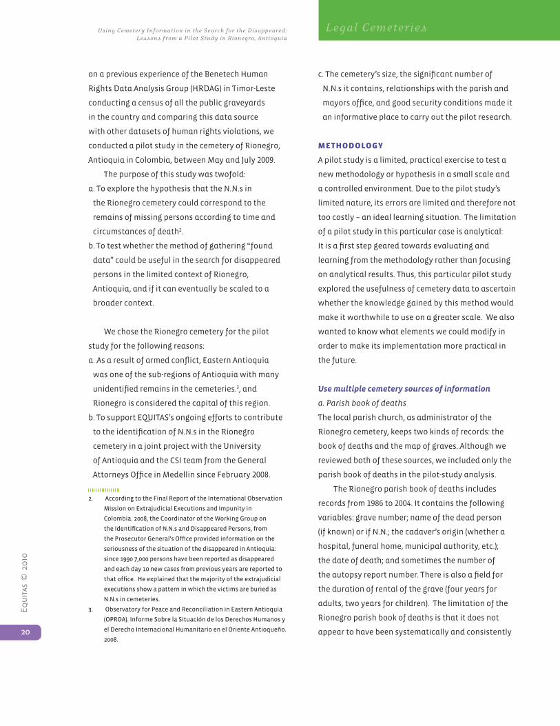
b. The gravedigger’s notebook
A simple notebook provides a wealth of information
about the population of the cemetery. At Rionegro,
the gravedigger keeps a set of records going back to
1990 and up to the present. The variables it includes
are the grave number; the name of the dead person or
whether N.N.; sometimes the autopsy report number;
the date of death or, if N.N., of arrival at the cemetery
or of burial. The gravedigger registers the information
provided to him by legal, health, or parish personnel
about each corpse.
Unlike the parish map of graves, these entries
are not erased when the remains are moved from
their cemetery location, when grave leases expire, or
when N.N. remains are transferred to common graves.
Thus, the gravedigger’s notebook is probably the most
complete set of historical records about the cemetery
population. However, the accuracy and completeness
of such records depends on the quality of the gravedig-
ger’s notes and on how systematically and consistently
he keeps them. The gravedigger’s notebook comple-
ments the analysis: in this case, while the parish book’s
records begin ten years earlier than those of the grave-
digger, his notebook covers more recent years.
Photo 1. Gravedigger’s notebook
Equ
itas
© 2
010
22
Using Cemeter y Information in the Search for the Disappeared: Lessons from a Pilot Study in Rionegro, Antioquia
Legal Cemeteries
c. Census of gravestones
The census provided us with a full enumeration of
the cemetery population – that is, all the individuals
currently buried in the graves at the cemetery.4
We analyzed the data from the book of deaths,
the gravedigger’s notebook and the census data
together to get a more complete understanding of the
cemetery population. We used information about the
named dead in a study about N.N.s and disappeared
persons in order to address our hypothesis that the
N.N.s could be the remains of the disappeared. We
first need to reject the possibility that the N.N.s are
caused by “normal” circumstances5.
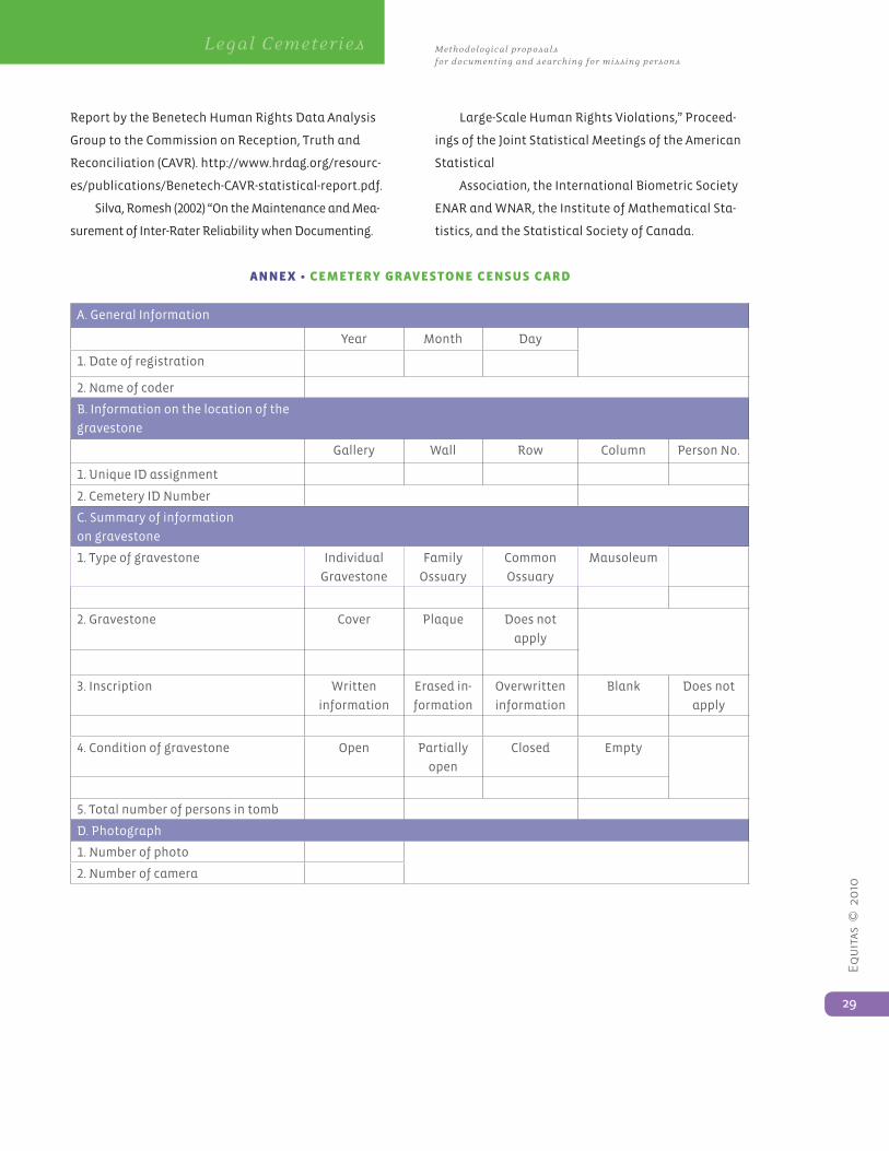
data CoLLeCtIon foR gRavestone Census
Of the three sources used, only the gravestone census
required a data collection effort. In this section, we
describe the steps in the process.
a. Reference frame
The first step in any census is to obtain a reference
frame. A reference frame delineates the population
to be studied and includes each unit of the given
population. In the case of the cemetery, a map would
have been a good reference frame. The existing map
held by the parish was considerably out of date and
so the project hired an architect to draw a new one.
4. Wedidnotincludethecommongravesinthecensus,as
they are generally unmarked and there is no register of how
many corpses each contains. According to the gravedigger,
the Rionegro cemetery has seven common graves that could
contain hundreds and possibly thousands of human remains.
5. Societiesusuallyproduceunidentifieddeadasaresultof
“normal”eventssuchasdecedents’mentalillness,povertyand
socialmarginalization.Onewouldexpecttherelationbetween
theunidentifiedandidentifieddeadtoremainconstant.
Thuswemightexpecttoseeanincreaseinthenumberof
unidentifiedcadaverswhenthegeneralmortalityraterises,
andfewerN.N.swhentheoverallnumberofdeathsdrops.
Bycomparingthepatternsofthenamedandtheunnamed
dead,wecandetectan“excess”ofunidentifiedcadaversor
any unusual patterns that can then be investigated. Unusual
patterns may be due to natural disasters, epidemics and armed
conflict,amongotherreasons.
That became our reference frame, with which the
project team counted each grave in the cemetery. It
also helped us organize the field team in the different
areas of the cemetery.
In the mapping process we discovered that the
Rionegro parish had underestimated the number of
graves in the cemetery. Thus, while the number of
graves registered by the parish was between 3,000
and 4,000, the census counted 7,834.
b. Unique identification
With the cemetery map as reference frame,
the project team went on to design a unique
identification scheme for each of the graves in the
cemetery. The unique identification, which can be
thought of as the “address” of each dead person in
the cemetery, tells us exactly where each cadaver is
buried.
Photo 2. The architect with his map of the cemetery
Equ
itas
© 2
010
23
Methodological proposals for documenting and searching for missing persons
Legal Cemeteries
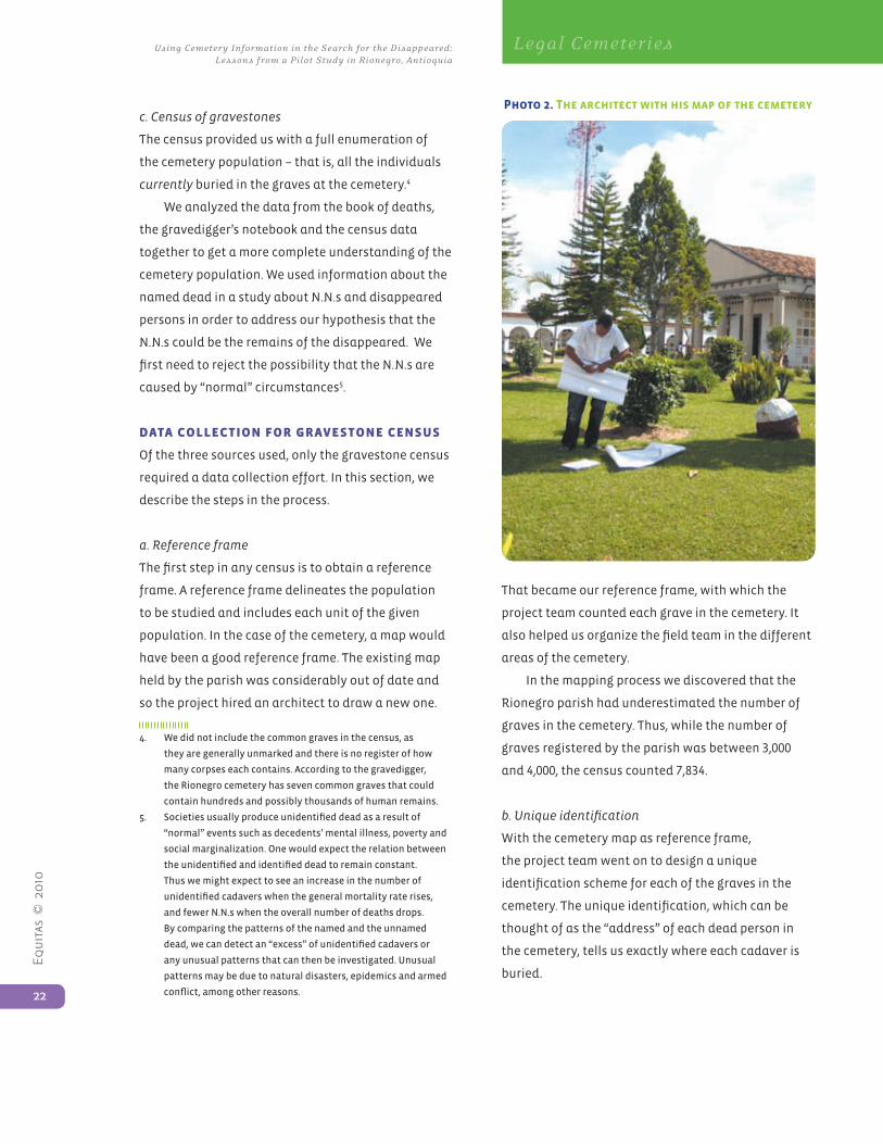
The unique identification created a consistent
reference to specific locations in the cemetery. It
was structured as follows: a code for each gallery
in the cemetery, where the graves are located on
walls; a code for each wall in the gallery; the row
number of the grave, assigned from bottom to top,
and the column number of the grave, assigned from
left to right; and a consecutive unique number for
each person buried in the grave (often more than
one, especially in the case of family graves). The only
exception was the five mausoleums, each of which
was assigned a unique number. It should be pointed
out that many graves had existing identification
numbers, but they were often repeated; frequently
they were missing. With the system of unique
identification, it is possible to keep track of each dead
person arriving at the cemetery.
Unique identification code structure:
1. Gallery - Wall- Row - Column – Person No.
2. Example: GW-D-09-30-01
c. Coding
Using a predetermined structure, a team of five
people systematically collected the following
information from each gravestone:
• Location of grave, using a unique ID assigned by us
• Information on conditions of the grave
• Information on the cadaver(s) in the grave
• Photo of the grave
Inter-rater reliability is the degree of agreement
among coders. It measures how much consensus
there is among the coding team in the application of
the criteria defined in the controlled vocabulary. We
calculated 97% reliability during the data collection
for this project. This high level of consistency gives us
great confidence in the reliability of the census data
(Silva, Romesh 2002).
d. Database
We created a dataset of all the information inscribed
on the cemetery gravestones. Using Martus, a free
Layout of Rionegro Cemetery drawn by project architect
Equ
itas
© 2
010
24
Using Cemeter y Information in the Search for the Disappeared: Lessons from a Pilot Study in Rionegro, Antioquia
Legal Cemeteries
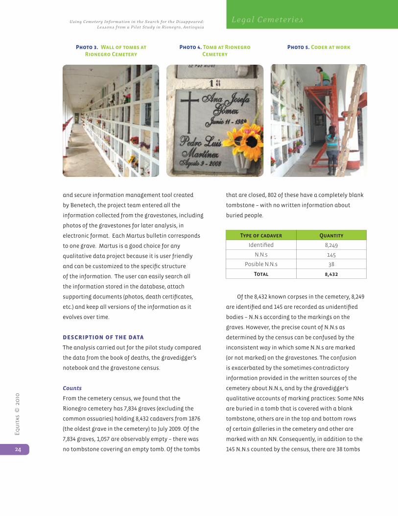
Photo 3. Wall of tombs at Rionegro Cemetery
and secure information management tool created
by Benetech, the project team entered all the
information collected from the gravestones, including
photos of the gravestones for later analysis, in
electronic format. Each Martus bulletin corresponds
to one grave. Martus is a good choice for any
qualitative data project because it is user friendly
and can be customized to the specific structure
of the information. The user can easily search all
the information stored in the database, attach
supporting documents (photos, death certificates,
etc.) and keep all versions of the information as it
evolves over time.
desCRIptIon of the data
The analysis carried out for the pilot study compared
the data from the book of deaths, the gravedigger’s
notebook and the gravestone census.
Counts
From the cemetery census, we found that the
Rionegro cemetery has 7,834 graves (excluding the
common ossuaries) holding 8,432 cadavers from 1876
(the oldest grave in the cemetery) to July 2009. Of the
7,834 graves, 1,057 are observably empty – there was
no tombstone covering an empty tomb. Of the tombs
that are closed, 802 of these have a completely blank
tombstone – with no written information about
buried people.
Type of cadaver Quantity
Identified 8,249
N.N.s 145
Posible N.N.s 38
Total 8,432
Of the 8,432 known corpses in the cemetery, 8,249
are identified and 145 are recorded as unidentified
bodies – N.N.s according to the markings on the
graves. However, the precise count of N.N.s as
determined by the census can be confused by the
inconsistent way in which some N.N.s are marked
(or not marked) on the gravestones. The confusion
is exacerbated by the sometimes-contradictory
information provided in the written sources of the
cemetery about N.N.s, and by the gravedigger’s
qualitative accounts of marking practices: Some NNs
are buried in a tomb that is covered with a blank
tombstone, others are in the top and bottom rows
of certain galleries in the cemetery and other are
marked with an NN. Consequently, in addition to the
145 N.N.s counted by the census, there are 38 tombs
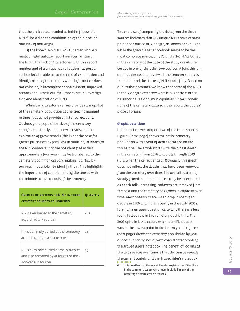
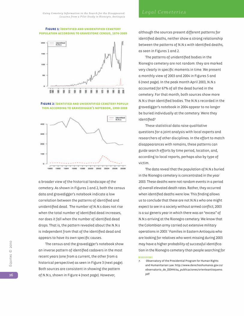
Photo 5. Coder at work Photo 4. Tomb at Rionegro Cemetery
Equ
itas
© 2
010
25
Methodological proposals for documenting and searching for missing persons
Legal Cemeteries
that the project team coded as holding “possible
N.N.s” (based on the combination of their location
and lack of markings).
Of the known 145 N.N.s, 45 (31 percent) have a
medical-legal autopsy report number written on
the tomb. The lack of gravestones with this report
number and of a unique identification has posed
serious legal problems, at the time of exhumation and
identification of the remains when information does
not coincide, is incomplete or non existent. Improved
records at all levels will facilitate eventual investiga-
tion and identification of N.N.s.
While the gravestone census provides a snapshot
of the cemetery population at one specific moment
in time, it does not provide a historical account.
Obviously the population size of the cemetery
changes constantly due to new arrivals and the
expiration of grave rentals (this is not the case for
graves purchased by families). In addition, in Rionegro
the N.N. cadavers that are not identified within
approximately four years may be transferred to the
cemetery’s common ossuary, making it difficult –
perhaps impossible – to identify them. This highlights
the importance of complementing the census with
the administrative records of the cemetery.
Overlap of records of N.N.s in three
cemetery sources at Rionegro
Quantity
N.N.s ever buried at the cemetery
according to 3 sources
462
N.N.s currently buried at the cemetery
according to gravestone census
145
N.N.s currently buried at the cemetery
and also recorded by at least 1 of the 2
non-census sources
73
The exercise of comparing the data from the three
sources indicates that 462 unique N.N.s have at some
point been buried at Rionegro, as shown above.6 And
while the gravedigger’s notebook seems to be the
most complete source, only 73 of the 145 N.N.s buried
in the cemetery at the date of the study are also re-
corded in one of the other two sources. Again, this un-
derlines the need to review all the cemetery sources
to understand the status of N.N.s more fully. Based on
qualitative accounts, we know that some of the N.N.s
in the Rionegro cemetery were brought from other
neighboring regional municipalities. Unfortunately,
none of the cemetery data sources record the bodies’
place of origin.
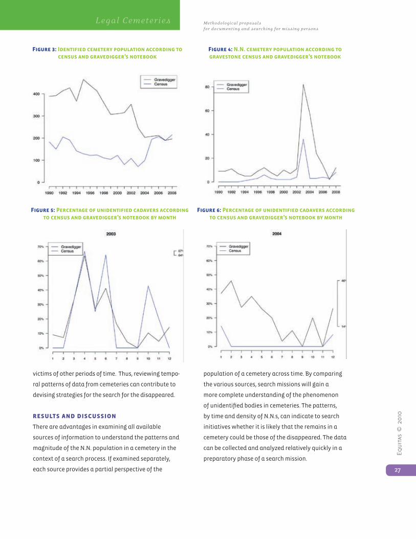
Graphs over time
In this section we compare two of the three sources.
Figure 1 (next page) shows the entire cemetery
population with a year of death recorded on the
tombstone. The graph starts with the oldest death
in the cemetery from 1876 and plots through 2009
(July, when the census ended). Obviously this graph
does not reflect the deaths that have been removed
from the cemetery over time. The overall pattern of
steady growth should not necessarily be interpreted
as death tolls increasing: cadavers are removed from
the past and the cemetery has grown in capacity over
time. Most notably, there was a drop in identified
deaths in 1986 and more recently in the early 2000s.
It remains an open question as to why there are less
identified deaths in the cemetery at this time. The
2003 spike in N.N.s occurs when identified death
was at the lowest point in the last 30 years. Figure 2
(next page) shows the cemetery population by year
of death (or entry, not always consistent) according
the gravedigger’s notebook. The benefit of looking at
the two sources over time is that the census reveals
the current burials and the gravedigger’s notebook
6. Itispossiblethatthereisstillunder-registration,iftheN.N.s
in the common ossuary were never included in any of the
cemetery’sadministrativerecords.
Equ
itas
© 2
010
26
Using Cemeter y Information in the Search for the Disappeared: Lessons from a Pilot Study in Rionegro, Antioquia
Legal Cemeteries
a broader view of the historical landscape of the
cemetery. As shown in Figures 1 and 2, both the census
data and gravedigger’s notebook indicate a low
correlation between the patterns of identified and
unidentified dead. The number of N.N.s does not rise
when the total number of identified dead increases,
nor does it fall when the number of identified dead
drops. That is, the pattern revealed about the N.N.s
is independent from that of the identified dead and
appears to have its own specific causes.
The census and the gravedigger’s notebook show
an inverse pattern of identified cadavers in the most
recent years (one from a current, the other from a
historical perspective) as seen in Figure 3 (next page).
Both sources are consistent in showing the pattern
of N.N.s, shown in Figure 4 (next page). However,
although the sources present different patterns for
identified deaths, neither show a strong relationship
between the patterns of N.N.s with identified deaths,
as seen in Figures 1 and 2.
The patterns of unidentified bodies in the
Rionegro cemetery are not random: they are marked
very clearly in specific moments in time. We present
a monthly view of 2003 and 2004 in Figures 5 and
6 (next page). In the peak month April 2003, N.N.s
accounted for 67% of all the dead buried in the
cemetery. For that month, both sources show more
N.N.s than identified bodies. The N.N.s recorded in the
gravedigger’s notebook in 2004 appear to no longer
be buried individually at the cemetery. Were they
identified?
These statistical data raise qualitative
questions for a joint analysis with local experts and
researchers of other disciplines. In the effort to match
disappearances with remains, these patterns can
guide search efforts by time period, location, and,
according to local reports, perhaps also by type of
victim.
The data reveal that the population of N.N.s buried
in the Rionegro cemetery is concentrated in the year
2003. These deaths were not random events in a period
of overall elevated death rates. Rather, they occurred
when identified deaths were low. This finding allows
us to conclude that these are not N.N.s who one might
expect to see in a society without armed conflict; 2003
is a sui generis year in which there was an “excess” of
N.N.s arriving at the Rionegro cemetery. We know that
the Colombian army carried out extensive military
operations in 2003.7 Families in Eastern Antioquia who
are looking for relatives who went missing during 2003
may have a higher probability of successful identifica-
tion in the Rionegro cemetery than people searching for
7. ObservatoryofthePresidentialProgramforHumanRights
andHumanitarianLaw:http://www.derechoshumanos.gov.co/
observatorio_de_DDHH/04_publicaciones/orienteantioqueno.
Figure 1: Identified and unidentified cemetery population according to gravestone census, 1876-2009
Figure 2: Identified and unidentified cemetery popula-tion according to gravedigger’s notebook, 1990-2008
Equ
itas
© 2
010
27
Methodological proposals for documenting and searching for missing persons
Legal Cemeteries
Figure 5: Percentage of unidentified cadavers according to census and gravedigger’s notebook by month
victims of other periods of time. Thus, reviewing tempo-
ral patterns of data from cemeteries can contribute to
devising strategies for the search for the disappeared.
ResuLts and dIsCussIon
There are advantages in examining all available
sources of information to understand the patterns and
magnitude of the N.N. population in a cemetery in the
context of a search process. If examined separately,
each source provides a partial perspective of the
population of a cemetery across time. By comparing
the various sources, search missions will gain a
more complete understanding of the phenomenon
of unidentified bodies in cemeteries. The patterns,
by time and density of N.N.s, can indicate to search
initiatives whether it is likely that the remains in a
cemetery could be those of the disappeared. The data
can be collected and analyzed relatively quickly in a
preparatory phase of a search mission.
Figure 3: Identified cemetery population according to census and gravedigger’s notebook
Figure 4: N.N. cemetery population according to gravestone census and gravedigger’s notebook
Figure 6: Percentage of unidentified cadavers according to census and gravedigger’s notebook by month
Equ
itas
© 2
010
28
Using Cemeter y Information in the Search for the Disappeared: Lessons from a Pilot Study in Rionegro, Antioquia
Legal Cemeteries
• Cemetery administrators should keep accurate
records – for their own bookkeeping and for the
contribution they will make to the process of
identification of the N.N.s in their cemetery. In
particular, we recommend that cemeteries keep an
historical and up-to-date “census” of the graves and
the remains they contain.
• Cemetery administrators should create a unique
identification system for each single grave, so that
individual remains can be located and tracked when
moved. A unique identification system will help
cemetery administrators as well as local authorities
to locate each grave and individual buried in the
cemetery.
While this was a pilot study to test the potential
of a data source in search and identification missions,
the analysis has raised some important questions,
noted throughout this paper. With additional
qualitative research and quantitative data, these
substantive questions could be investigated. For
instance, the sources of information reviewed in
this pilot study could be compared with reports
of conflict-related disappearances and accounts
of combats in the area in order to determine more
clearly whether certain disappearances match
individual remains in a cemetery.
Also, the knowledge gained through the
quantitative study of the population in the
cemeteries could be complemented with qualitative
contextual research. The quantitative study can
corroborate or invalidate qualitative hypotheses,
such as whether N.N. from other regions were
buried in municipal cemeteries, which actors may
be likely perpetrators, etc. The data from Rionegro
could be combined and analyzed with other existing
sources, such as official deaths and homicide records,
population data, registries from other cemeteries in
region, etc.
aCKnoWLedgMents
We wish to thank the Rionegro parish church
for generously sharing the cemetery records with
Benetech and EQUITAS, as well as for letting us carry
out the gravestone census in the cemetery. We wish
to thank the British Embassy for financing the pilot
study. We would also like to thank the Sigrid Rausing
Trust for their support to Benetech projects in Colom-
bia. Our thanks also to Diana Garcia for leading the
team in the cemetery and to all the coders for collect-
ing the data and organizing it in the database.
Tamy Guberek coordinated the project, trained
the field staff and wrote the report. Daniel Guzmán
conducted the data analysis. Beatriz Vejarano edited
and translated the report.
BIBLIogRaphy
Asher, Jana, David Banks, and Fritz J. Scheuren
(Eds.). 2008. Statistical Methods for Human Rights.
Springer.
Asher, Jana, Patrick Ball, Wendy Betts, Fritz J. Sch-
euren, and Jana Dudokovic. 2002. Killings and Refugee
Flow in Kosovo March - June 1999. Washington, DC:
AAAS. http://shr.aaas.org/kosovo/icty_report.pdf
International Observation Mission on Extrajudicial
Executions and Impunity in Colombia, Observatory on
Human Rights and International Humanitarian Law
and Coordinación Colombia-Europa-Estados Unidos.
2008. Final Report, Documentos temáticos. n. º 4, p. 63.
Observatory for Peace and Reconciliation in East-
ern Antioquia (Observatorio de Paz y Reconciliación
del Oriente Antioqueño - OPROA). Informe Sobre La
Situación de Los Derechos Humanos y El Derecho Inter-
nacional Humanitario en El Oriente Antioqueño. 2008.
Programa Presidencial de Derechos Humanos
y Derecho Internacional Humanitario, Observatorio
de Derechos Humanos. 2004. Estudios Regionales,
Panorama Actual del Oriente Antioqueño.
Silva Romesh and Patrick Ball. 2006. The Profile
of Human Rights Violations in Timor-Leste, 1974-1999.
Equ
itas
© 2
010
29
Methodological proposals for documenting and searching for missing persons
Legal Cemeteries
Report by the Benetech Human Rights Data Analysis
Group to the Commission on Reception, Truth and
Reconciliation (CAVR). http://www.hrdag.org/resourc-
es/publications/Benetech-CAVR-statistical-report.pdf.
Silva, Romesh (2002) “On the Maintenance and Mea-
surement of Inter-Rater Reliability when Documenting.
Large-Scale Human Rights Violations,” Proceed-
ings of the Joint Statistical Meetings of the American
Statistical
Association, the International Biometric Society
ENAR and WNAR, the Institute of Mathematical Sta-
tistics, and the Statistical Society of Canada.
Annex • CeMeteRy gRavestone Census CaRd
A. General Information
Year Month Day
1. Date of registration
2. Name of coder
B. Information on the location of the
gravestone
Gallery Wall Row Column Person No.
1. Unique ID assignment
2. Cemetery ID Number
C. Summary of information
on gravestone
1. Type of gravestone Individual
Gravestone
Family
Ossuary
Common
Ossuary
Mausoleum
2. Gravestone Cover Plaque Does not
apply
3. Inscription Written
information
Erased in-
formation
Overwritten
information
Blank Does not
apply
4. Condition of gravestone Open Partially
open
Closed Empty
5. Total number of persons in tomb
D. Photograph
1. Number of photo
2. Number of camera

Archaeological desk
based assesment
for the search of
missing persons
in La Escombrera
construction debris
dump (Medellín,
Colombia)
Kevin Lane, PhD
abstract: Archaeological methods
such as survey and excavation are
key to the search and investigation of
missing persons. Human Rights and
Victim organizations have reported The
Escombrera construction debris dump
in Medellín, Colombia as a place where
approximately 400 missing persons could
be deposited, in to armed activities
perpetrated by the military operation
Orión in 2002 followed by paramilitary
activity. Finding remains of people in such
a scenario has been discarded by state
investigators due to the technical and
economic costs it might entail. However,
this is one more of the challenging
scenarios in which archaeology can offer
techniques and recovery possibilities that
should be explored in order to scientifically
exhaust efforts to investigate and return
these missing persons to their loved ones.
Key Words: Forensic archaeology,
construction debris dump, archaeological
survey, missing persons.
IntRoduCtIon
Why does forensic investigation require archaeology?
The simple answer is that forensic investigation
requires the excavation of a grave or deposition
of human remains and the fact remains that the
best tried and tested method for excavation is the
archaeological method. Archaeological method
becomes even more relevant when the location of
the buried is unknown. Detection by archaeological
means is an increasingly sophisticated affair.
Everything that is buried, be it Prehispanic or
from yesterday, becomes essentially ‘archaeology’
and its recovery through archaeological survey and
excavation must be pursued through the application
of rigorous methods applying to all places and at all
Equ
itas
© 2
010
31Co
nst
ruct
ion
deb
ris
du
mp
Methodological proposals for documenting and searching for missing persons
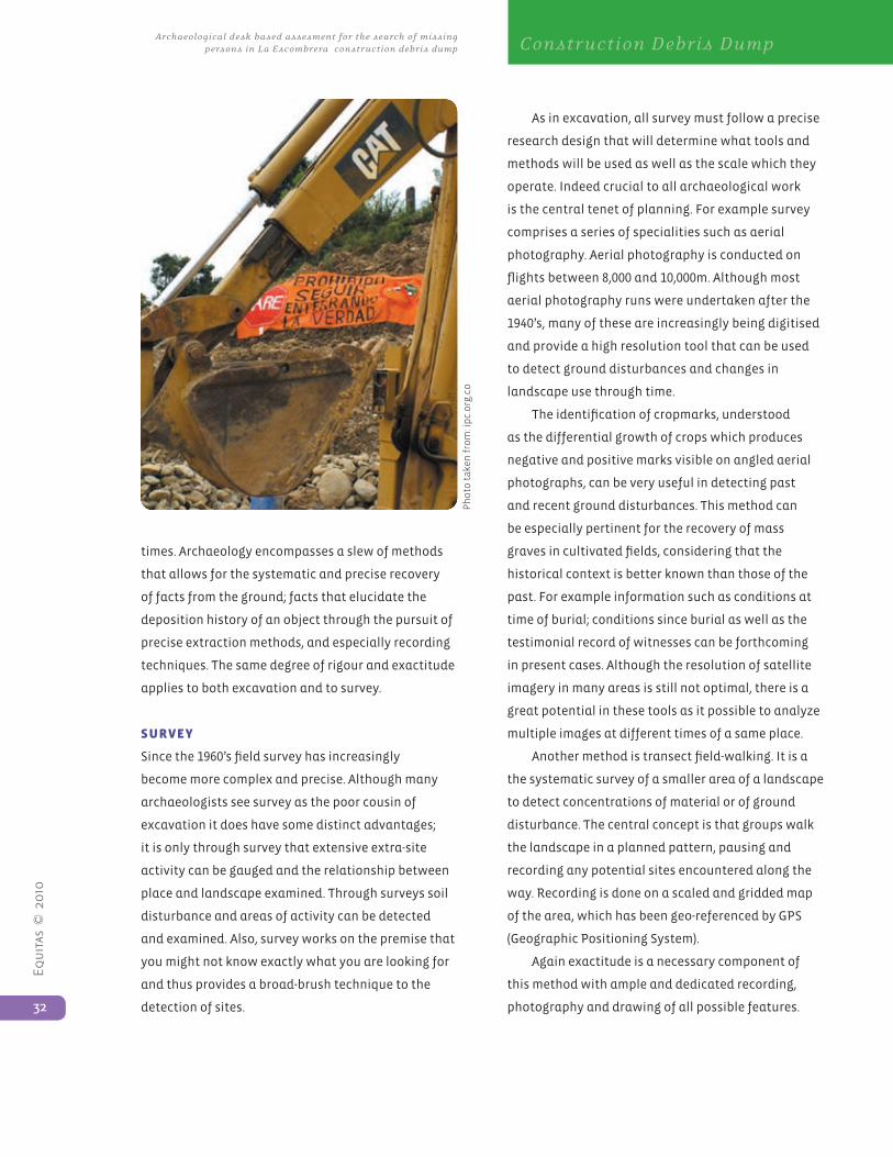
Equ
itas
© 2
010
32
Archaeological desk based assesment for the search of missing persons in La Escombrera construction debris dump Construction Debris Dump
times. Archaeology encompasses a slew of methods
that allows for the systematic and precise recovery
of facts from the ground; facts that elucidate the
deposition history of an object through the pursuit of
precise extraction methods, and especially recording
techniques. The same degree of rigour and exactitude
applies to both excavation and to survey.
suRvey
Since the 1960’s field survey has increasingly
become more complex and precise. Although many
archaeologists see survey as the poor cousin of
excavation it does have some distinct advantages;
it is only through survey that extensive extra-site
activity can be gauged and the relationship between
place and landscape examined. Through surveys soil
disturbance and areas of activity can be detected
and examined. Also, survey works on the premise that
you might not know exactly what you are looking for
and thus provides a broad-brush technique to the
detection of sites.
As in excavation, all survey must follow a precise
research design that will determine what tools and
methods will be used as well as the scale which they
operate. Indeed crucial to all archaeological work
is the central tenet of planning. For example survey
comprises a series of specialities such as aerial
photography. Aerial photography is conducted on
flights between 8,000 and 10,000m. Although most
aerial photography runs were undertaken after the
1940’s, many of these are increasingly being digitised
and provide a high resolution tool that can be used
to detect ground disturbances and changes in
landscape use through time.
The identification of cropmarks, understood
as the differential growth of crops which produces
negative and positive marks visible on angled aerial
photographs, can be very useful in detecting past
and recent ground disturbances. This method can
be especially pertinent for the recovery of mass
graves in cultivated fields, considering that the
historical context is better known than those of the
past. For example information such as conditions at
time of burial; conditions since burial as well as the
testimonial record of witnesses can be forthcoming
in present cases. Although the resolution of satellite
imagery in many areas is still not optimal, there is a
great potential in these tools as it possible to analyze
multiple images at different times of a same place.
Another method is transect field-walking. It is a
the systematic survey of a smaller area of a landscape
to detect concentrations of material or of ground
disturbance. The central concept is that groups walk
the landscape in a planned pattern, pausing and
recording any potential sites encountered along the
way. Recording is done on a scaled and gridded map
of the area, which has been geo-referenced by GPS
(Geographic Positioning System).
Again exactitude is a necessary component of
this method with ample and dedicated recording,
photography and drawing of all possible features.
Ph
oto
tak
en f
rom
: ip
c.o
rg.c
o
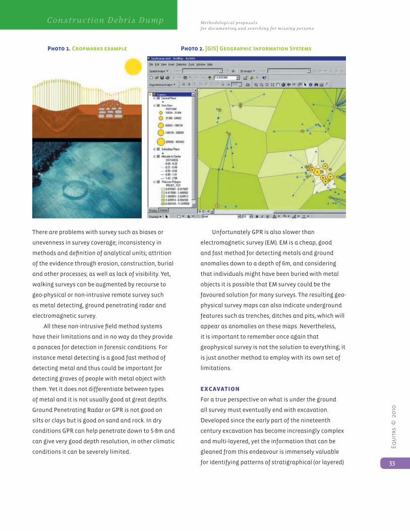
Equ
itas
© 2
010
33
Methodological proposals for documenting and searching for missing persons
Construction Debris Dump
There are problems with survey such as biases or
unevenness in survey coverage; inconsistency in
methods and definition of analytical units; attrition
of the evidence through erosion, construction, burial
and other processes; as well as lack of visibility. Yet,
walking surveys can be augmented by recourse to
geo-physical or non-intrusive remote survey such
as metal detecting, ground penetrating radar and
electromagnetic survey.
All these non-intrusive field method systems
have their limitations and in no way do they provide
a panacea for detection in forensic conditions. For
instance metal detecting is a good fast method of
detecting metal and thus could be important for
detecting graves of people with metal object with
them. Yet it does not differentiate between types
of metal and it is not usually good at great depths.
Ground Penetrating Radar or GPR is not good on
silts or clays but is good on sand and rock. In dry
conditions GPR can help penetrate down to 5-8m and
can give very good depth resolution, in other climatic
conditions it can be severely limited.
Unfortunately GPR is also slower than
electromagnetic survey (EM). EM is a cheap, good
and fast method for detecting metals and ground
anomalies down to a depth of 6m, and considering
that individuals might have been buried with metal
objects it is possible that EM survey could be the
favoured solution for many surveys. The resulting geo-
physical survey maps can also indicate underground
features such as trenches, ditches and pits, which will
appear as anomalies on these maps. Nevertheless,
it is important to remember once again that
geophysical survey is not the solution to everything; it
is just another method to employ with its own set of
limitations.
exCavatIon
For a true perspective on what is under the ground
all survey must eventually end with excavation.
Developed since the early part of the nineteenth
century excavation has become increasingly complex
and multi-layered, yet the information that can be
gleaned from this endeavour is immensely valuable
for identifying patterns of stratigraphical (or layered)
Photo 1. Cropmarks example Photo 2. [GIS] Geographic Information Systems
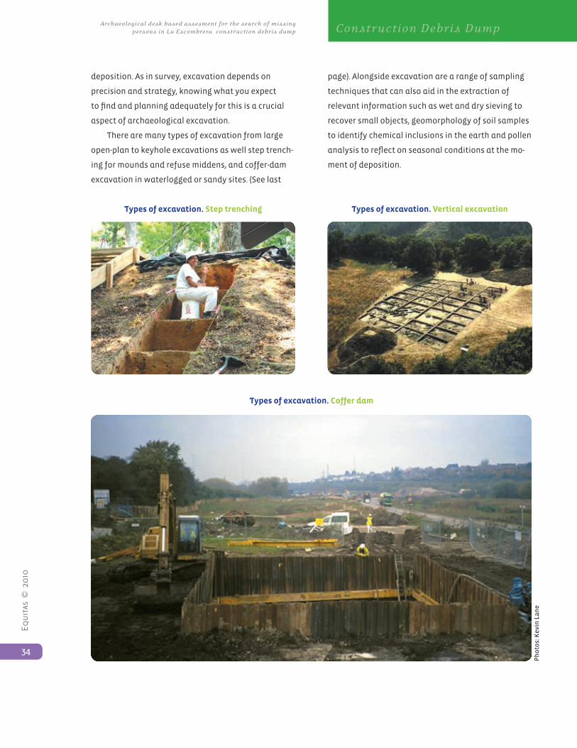
Equ
itas
© 2
010
34
Archaeological desk based assesment for the search of missing persons in La Escombrera construction debris dump Construction Debris Dump
deposition. As in survey, excavation depends on
precision and strategy, knowing what you expect
to find and planning adequately for this is a crucial
aspect of archaeological excavation.
There are many types of excavation from large
open-plan to keyhole excavations as well step trench-
ing for mounds and refuse middens, and coffer-dam
excavation in waterlogged or sandy sites. (See last
page). Alongside excavation are a range of sampling
techniques that can also aid in the extraction of
relevant information such as wet and dry sieving to
recover small objects, geomorphology of soil samples
to identify chemical inclusions in the earth and pollen
analysis to reflect on seasonal conditions at the mo-
ment of deposition.
Types of excavation. Step trenching
Types of excavation. Coffer dam
Types of excavation. Vertical excavation
Ph
oto
s: K
evin
La
ne
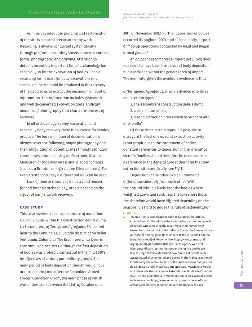
Equ
itas
© 2
010
35
Methodological proposals for documenting and searching for missing persons
Construction Debris Dump
As in survey adequate gridding and sectorisation
of the site is a crucial precursor to any work.
Recording is always conducted systematically
through pro forma recording sheets known as context
forms, photography, and drawing. Attention to
detail is incredibly important for all archaeology but
especially so for the excavation of bodies. Special
recording forms exist for body excavations and
special delicacy should be employed in the recovery
of the dead so as to extract the maximum amount of
information. This information includes systematic
and well documented excavation and significant
amounts of photography that charts the process of
recovery.
In all archaeology, survey, excavation and
especially body recovery there is no excuse for shoddy
practice. The bare minimum of documentation will
always cover the following, ample photography and
the triangulation of potential sites through standard
coordinates obtained using an Electronic Distance
Measurer (or tape measures) and a good compass
(such as a Brunton or high calibre Silva compass). For
even greater accuracy a differential GPS can be used.
Lack of time or resources is not a valid reason
for bad forensic archaeology, others depend on the
rigour of our fieldwork recovery.
Case study
This case involves the disappearance of more than
400 individuals within the construction debris dump
La Escombrera, of Terrigenos Agregados SA located
near to the Comuna 13, El Salado district of Medellin
(Antioquia, Colombia). The Escombrera has been in
constant use since 1990, although the first deposition
of bodies was probably carried out in the mid-1990’s
by effectives of various paramilitary groups. The
main period of body deposition though would have
occurred during and after the Colombian Armed
Forces ‘Operación Orion’, the main phase of which
was undertaken between the 16th of October and
30th of November 2002. Further deposition of bodies
occurred throughout 2003, and subsequently, as part
of mop-up operations conducted by legal and illegal
armed groups.1
An adjacent escombrera (Proparques El Sol) does
not seem to have been the object of body deposition
but is included within the general area of impact.
The main site, given the available evidence, is that
of Terrigenos Agregados, which is divided into three
main terrain types:
1. The escombrera construction debris dump;
2. a small natural lake;
3. a sand extraction area known as ‘Arenera Alta’
or ‘Arenilla’.
Of these three terrain types it is possible to
disregard the last one as sand extraction activity
is not propitious to the internment of bodies.
Constant references to deposition in the ‘arenal’ by
victim’s families should therefore be taken more as
a reference to the general area rather than the sand
extraction site specifically (see Fig 1).
Deposition in the other two environments
differed considerably from each other. Within
the natural lake it is likely that the bodies where
weighted down and sunk near the lake shore (note:
the shoreline would have differed depending on the
season). It is hard to gauge the rate of sedimentation
1. HumanRightsorganizationssuchasCorporaciónJurídica
LibertadandCodheselhavedocumentedmorethan70reports
of people who were illegally taken from their homes after
November2002,aspartofthemilitaryOperaciónOriónwiththe
purposeoffindingguerrillamembersattheElSaladoComuna
(neighbourhood) of Medellín. See: http://www.prensarural.
org/spip/spip.php?article1885 (IPC Press Agency website).
Also,paramilitarytestimoniesundertheJusticeandPeace
law,during2007havedescribedhowdozensofpeoplewere
assassinated, dismembered and buried in the highest section of
El Salado by the Metro section of the Autodefensas Campesinas
deCórdobayUrabá(Accu)CaciqueNutibara,MagdalenaMedio
andHéroesdeGranadadelasAutodefensasUnidasdeColombia
(Auc).In:TheEscombrerainMedellín,shouldbeasymbol,article
inSemana.com.http://www.semana.com/noticias-conflicto-
armado/escombrera-medellin-debe-simbolo/117428.aspx
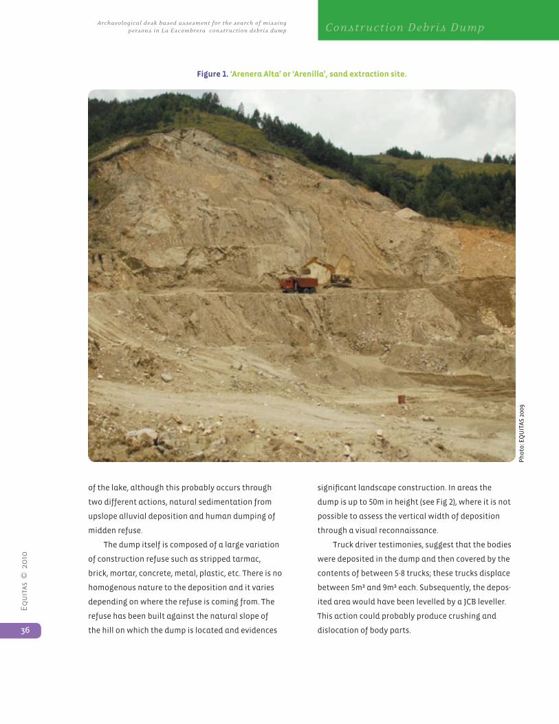
Equ
itas
© 2
010
36
Archaeological desk based assesment for the search of missing persons in La Escombrera construction debris dump Construction Debris Dump
of the lake, although this probably occurs through
two different actions, natural sedimentation from
upslope alluvial deposition and human dumping of
midden refuse.
The dump itself is composed of a large variation
of construction refuse such as stripped tarmac,
brick, mortar, concrete, metal, plastic, etc. There is no
homogenous nature to the deposition and it varies
depending on where the refuse is coming from. The
refuse has been built against the natural slope of
the hill on which the dump is located and evidences
significant landscape construction. In areas the
dump is up to 50m in height (see Fig 2), where it is not
possible to assess the vertical width of deposition
through a visual reconnaissance.
Truck driver testimonies, suggest that the bodies
were deposited in the dump and then covered by the
contents of between 5-8 trucks; these trucks displace
between 5m³ and 9m³ each. Subsequently, the depos-
ited area would have been levelled by a JCB leveller.
This action could probably produce crushing and
dislocation of body parts.
Figure 1. ‘Arenera Alta’ or ‘Arenilla’, sand extraction site.
Photo:EQUITAS2009
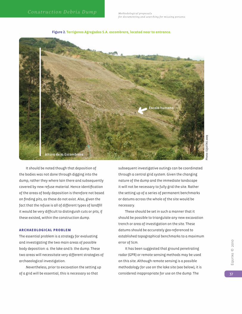
Equ
itas
© 2
010
37
Methodological proposals for documenting and searching for missing persons
Construction Debris Dump
It should be noted though that deposition of
the bodies was not done through digging into the
dump, rather they where lain there and subsequently
covered by new refuse material. Hence identification
of the areas of body deposition is therefore not based
on finding pits, as these do not exist. Also, given the
fact that the refuse is all of different types of landfill
it would be very difficult to distinguish cuts or pits, if
these existed, within the construction dump.
aRChaeoLogICaL pRoBLeM
The essential problem is a strategy for evaluating
and investigating the two main areas of possible
body deposition: a. the lake and b. the dump. These
two areas will necessitate very different strategies of
archaeological investigation.
Nevertheless, prior to excavation the setting up
of a grid will be essential, this is necessary so that
subsequent investigative outings can be coordinated
through a central grid system. Given the changing
nature of the dump and the immediate landscape
it will not be necessary to fully grid the site. Rather
the setting up of a series of permanent benchmarks
or datums across the whole of the site would be
necessary.
These should be set in such a manner that it
should be possible to triangulate any new excavation
trench or area of investigation on the site. These
datums should be accurately geo-referenced to
established topographical benchmarks to a maximum
error of 5cm.
It has been suggested that ground penetrating
radar (GPR) or remote sensing methods may be used
on this site. Although remote sensing is a possible
methodology for use on the lake site (see below), it is
considered inappropriate for use on the dump. The
Figure 2. Terrigenos Agregados S.A. escombrera, located near to entrance.
Photo:EQUITAS2009
Escala humana
Altura de la Escombrera
Equ
itas
© 2
010
38
Archaeological desk based assesment for the search of missing persons in La Escombrera construction debris dump Construction Debris Dump
reasons for this are manifold and some of the more
salient points are summarized below:
1. Most GPR systems function on the basis of finding
underground features, as we have stated above nei-
ther the lake site nor the midden have recognisable
archaeological features such as pits or ditches;
2. GPR and remote sensing are accurate to a total
maximum distance of 5-8m; given that the dump
is up to 50m in depth it is highly unlikely that
these methods will yield significant results. This
assumption is taken on the understanding that
the deposition of the bodies occurred mainly in the
2002-2003 bracket, so that given the increase of the
midden it is very likely that the bodies are at depths
below the range of GPR or remote sensing;
3. Most remote sensing techniques are very
susceptible to the presence of metals, as this
is a construction midden the presence of high
concentrations of metal is assured. Therefore
the survey will be heavily contaminated by these
secondary, non-relevant signals.
In lieu of these problems we suggest a different
more traditional approach to the problem, which uti-
lises a sound desk-based assessment of the archaeol-
ogy coupled with excavation and survey.
MethodoLogICaL pRoposaL
There is a significant problem of scale in tackling
this site; essentially the site is too large, vertically
and horizontally, to effectively propose the complete
excavation of the area. Given these circumstances
it is crucial to establish limits of what is possible,
as such we propose a preliminary coordinated
investigation of the site to see the potential of the
methodologies suggested here.
To prioritise this investigation of the site we
propose to study both the lake and the dump. The
separate methodologies for both are described below:
LaKe InvestIgatIon:
The lake has an advantage over the midden in that
it is a relatively natural, and self-contained site. As
mentioned above, deposition of the bodies in the
lake was possibly through weighting of the bodies
and then through natural silting and possibly some
dumping. Given that the lake is still visible we can
assume that dumping has not been a significant
factor in the infilling of the lake.
Firstly, the recommendation is for draining of the
lake so that we achieve a dry surface; underwater
archaeology would not be viable given the lack of
visibility in this lake. Once the lake has been dried
off, it would be necessary to set up a geo-referenced
grid (5m x 5m grid squares) that covered the whole of
the lake. Care should be taken to include at least 5m
of bank as it is possible that the lake has shrunk over
time so that the original lakeshore stood further back
than is now the case.
Once the lake has been gridded, two
methodologies may be employed; the first is the use
of Electromagnetic (EM) conductivity equipment
(this method is a good, fast method for detecting
metals and ground anomalies down to a depth of 6m).
Although we do expect any ground anomalies and
given that metal contamination might be a factor this
method might also locate victims that were deposited
here with metal objects such as buckles, shoes, etc.
Secondly, the lake should be sampled through
the trench excavation of a sample of no less than 20%
of the lake area. These trenches should be no less
than 1m in width and should be so placed that they
intersect a series of terrains such as the lake bank,
immediate shore and lake proper. Given that the
bodies were probably deposited along the lakeshore
particular attention should be paid to this area. Also,
concentration along the motor access point to the lake
should be particularly targeted. The trenches should
be spaced so that the 20% sample encompasses a
statistically significant area of the lake site.
Equ
itas
© 2
010
39
Methodological proposals for documenting and searching for missing persons
Construction Debris Dump
Excavation of the lake can be undertaken
through closely monitored machine stripping of the
overlaying sediment as the deposition of the bod-
ies in the lake will not have created any observable
archaeological feature just silting over the remains.
Stripping of the sediments should be done under
close supervision and of depths of no more than
between 5-10cm across the horizontal plane using a
small excavator with a bucket of no more than
1.2-1.5m in width.
Excavation by hand will be undertaken
immediately after the discovery of any item worthy of
investigation. These excavations will be linked to the
main grid set out during the initial survey of the lake.
Excavation of all items in the lake sediment should
be conducted meticulously by hand following the
single-context excavation techniques standardised
by MoLAS (1994); excavation of bodies should also
use these standards and those set by the manuals of
Bass (1992) and Roskams (2001). Registration of every
archaeological context should include adequate
photography (with scales and north arrow), profile
and plan drawings, and context sheet descriptions
of each cut, fill and internal features or objects (if
any). After excavation, the opened tranches should
be re-filled and covered. All objects of archaeological
interest should be labelled and collected following
the standards set by the manuals mentioned above.
duMp InvestIgatIon:
The midden presents a much more serious problem
for purposes of our investigation. The initial phase
of investigation requires detailed information of
the formation of the midden. Because of the scale
of the midden it will only be possible to sample an
area of it, as such it is recommended that this initial
investigation focuses on the main period of body
deposition, that pertaining to the Operación Orion.
The reason behind this is simple, given the number
of people eliminated during this period we are more
likely to find evidence of this incidence than that of
an isolated body deposited at a later or earlier date.
Given the extent of the midden and the nature
of the deposit it is nevertheless essential to have
verifiable and reliable evidence of the state and
geography of the dump when the main period activity
associated to Operación Orion was underway. This
point is crucial, without this information it will be
extremely difficult to archaeologically investigate the
midden. As an adjunct it may be possible to access
aerial or satellite imagery pertaining to the period
in question to verify the geography of the midden at
this time. This preliminary assessment should give
us a depth and intervention area within which to
maximise our efforts.
This intervention area will have to be suitably
gridded and then sampled to not less than 20% of
the area through excavation using geo-referenced
trenches, located across the area so as to maximise
the possible location of the deposited bodies. At this
stage we are essentially striving for excavation of the
pre-determined intervention area. The conditions of
the midden suggest two possible ways of progressing:
1. Coffer-dam excavation (see Roskams 2001) – this
entails the shoring up of the vertical plane of the
excavation. Although consolidated, it is likely that
parts of the midden will only be weakly so, hence
it is important for the safety of the investigators
to shore-up the trench excavation down to the
archaeologically significant level.
The advantage of this method is that the area
of excavation can be controlled and it will not
be necessary to strip the whole of the midden
down to this level. The problem is the unknown
nature of the dump; should excavation uncover
an area of large construction refuse that extends
beyond the horizontal limits of the coffer-dam
trench, then it will be impossible to continue the
excavation. Furthermore, shoring will have to be of
a strong enough material (thick wood or reinforced
Equ
itas
© 2
010
40
Archaeological desk based assesment for the search of missing persons in La Escombrera construction debris dump Construction Debris Dump
corrugated iron sheeting) so that trench collapse
can be averted.
2. Dump removal and excavation – in the end this
might well be the desired method. This entails the
laborious removal of the midden down to the level
of possible body deposition. This would employ at
least three JCB excavators and a number of trucks to
remove the material to another part of the site.
The main problem with this method is the time
intensive nature of midden removal, the advantage
is that the whole of the intervention is open for
investigation and trail trenching.
Whatever the method employed, it is envisaged
that excavation through the use of large JCB’s will be
to a depth c.0.5m before the desired level. The reason
for this is to compensate for possible post-deposi-
tional movement of the midden and the possibility
of error in the gauging of depth in the original dump
depositional documentation. Once this level has been
attained, further wok will be undertaken much more
carefully, stripping in the region of between 5-10 cm.
Dry sieving of all this material will be required at this
stage given the possibly fragmentary nature of the
evidence. All this work should be closely monitored by
qualified archaeologists.
Excavation beyond this level will be done through
trenching and dry sieving of all material uncovered.
As with the lake investigation, excavation by hand
will be undertaken immediately after the discovery of
any item worthy of investigation. These excavations
will be linked to the main grid set out during the initial
survey of the midden area. Excavation of all items
in the midden should be conducted meticulously
by hand following the single-context excavation
techniques standardised by MoLAS (1994); excavation
of bodies should also follow these standards and
those set by the manuals of Bass (1992) and Roskams
(2001). Registration of every archaeological context
should include adequate photography (with scales
and north arrow), profile and plan drawings, and
context sheet descriptions of each cut, fill and internal
features or objects (if any). After excavation the
opened tranches should be re-filled and covered. All
objects of archaeological interest should be labelled
and collected following the standards set by the
manuals mentioned above.
It is estimated that an initial survey of the site to
test the viability of this method will take a minimum
of 4 weeks of continuous fieldwork.
aCnoWLedgMents
We would like to thank forensic anthropologist
Oscar Hidalgo from the CSI team of the National
Prosecutors Office in Medellín, for his interest in this
topic.
pReLIMInaRy LIst of equIpMent
and teaM CoMposItIon
• Standard excavation equipment – shovels, trowels,
string, nails, stakes, scales, north arrow, etc
• 3 x Mechanical excavator with a 3-4m bucket
• 1 x Mechanical mini excavator with a 1.2-1.5m bucket
• Total station set [topographer and one assistant
with prisms]
• Electromagnetic (EM) conductivity set [operator and
assistant]
• As a minimum the core team should comprise a
trained field archaeologist/anthropologist and three
assistants aside from the topography and geo-
physical teams.
RefeRenCes
Bass, W. M. 1992. Human Osteology: A Laboratory
and Field Manual. Columbia, USA: Missouri Archaeo-
logical Society. Special Publication 2
Blau, S., and D. H. Ubelaker. Editors. 2009. Hand-
book of Forensic Anthropology and Archaeology.
Walnut Creek, California: Left Coast Press.
Cheetham, P. N. 2008. “Noninvasive Subsurface
Mapping Techniques, Satellite and Aerial Imagery in
Equ
itas
© 2
010
41
Methodological proposals for documenting and searching for missing persons
Construction Debris Dump
Landscape Archaeology,” in Handbook of Landscape
Archaeology, World Archaeological Congress Re-
search Handbooks in Archaeology. Edited by B. David
and J. Thomas, pp. 562-582. Walnut Creek, California:
Left Coast Press.
Conolly, J. 2008. “Geographical Information
Systems and Landscape Archaeology,” in Handbook
of Landscape Archaeology, World Archaeological
Congress Research Handbooks in Archaeology. Edited
by B. David and J. Thomas, pp. 583-595. Walnut Creek,
California: Left Coast Press.
Denham, T. 2008. “Environmental Archaeology: In-
terpreting Practices-in-the-Landscape through Geoar-
chaeology,” in Handbook of Landscape Archaeology,
World Archaeological Congress Research Handbooks
in Archaeology. Edited by B. David and J. Thomas.
Walnut Creek, California: Left Coast Press.
Ferllini, R. Editor. 2007. Forensic Archaeology and
Human Rights Violations Springfield, Illinois: Charles
C. Thomas Publisher.
Haglund, W. D., and M. H. Sorg. Editors. 1997.
Forensic Taphonomy: The Postmortem Fate of Human
Remains. New York: CRC Press.
Hunter, J. R., and M. Cox. 2005. “Forensic Archaeol-
ogy: Advances in Theory and Practice.” Abingdon/New
York: Routledge.
Hunter, J. R., C. Roberts, and A. Martin. 1995. Stud-
ies in Crime: An Introduction to Forensic Archaeology.
Abingdon/New York: Routledge.
MoLAS. 1994. Archaeological Site Manual. Lon-
don: MoLAS.
Richards, T. 2008. “Survey Strategies in Landscape
Archaeology,” in Handbook of Landscape Archae-
ology, World Archaeological Congress Research
Handbooks in Archaeology. Edited by B. David and
J. Thomas, pp. 551-561. Walnut Creek, California: Left
Coast Press.
Roskams, S. 2001. Excavation. Cambridge Manuals
in Archaeology. Cambridge: Cambridge University Press.

Equ
itas
© 2
010
43
Methodological proposals for documenting and searching for missing persons
Construction Debris Dump
Remote sensing
analysis proposal
for the location
of clandestine
cemeteries next to
the Casanare River in
Colombia
Luz Adriana Guatame
abstract: This article suggests criteria for
the preliminary evaluation of search sites
through remote sensing analysis in order
to identify terrain modification patterns
as potential indicators of clandestine
burial sites. The study of several previous
exhumations pointed out that many of the
burials were associated to river and stream
natural drainages and to flood plains.
This finding implies a comprehensive study
of drainage behavior that would enable
researchers to find out to what extend
the burials have been affected by rushing
water passing over them, either erasing
superficial grave marks or covering them
with water sediments or displacing them
in some cases. Understanding how rivers
change in time, is a key element when
conducting regional search processes of
missing persons, based on testimonies.
Key words: clandestine burials, remote
sensing, natural drainages.
IntRoduCtIon
Processing and analyzing information obtained
through remote sensors such as satellite images or
aerial photographs, have proved to be an appropriate
methodology in various contexts in the search for
clandestine burials (Kalácska M. y Bell, 2006.) The
relevance of this methodology is based on the fact
that it allows the study of land surface properties,
characteristics and definition over considerable land
extensions in short periods of time and at a lower
cost than a field job would require. Furthermore, it
involves a methodology where there is no physical
contact with the field, offering abundant qualitative
information on the area and the potential existence
of clandestine burials, that will help to carry out
search planning and recovery activities and offer Cla
nd
esti
ne
bu
ria
ls
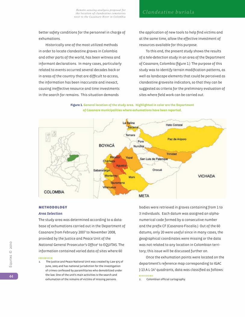
Equ
itas
© 2
010
44
Remote sensing analysis proposal for the location of clandestine cemeteries next to the Casanare River in Colombia
Clandestine burials
better safety conditions for the personnel in charge of
exhumations.
Historically one of the most utilized methods
in order to locate clandestine graves in Colombia
and other parts of the world, has been witness and
informant declarations. In many cases, particularly
related to events occurred several decades back or
in areas of the country that are difficult to access,
the information has been inaccurate and inexact,
causing ineffective resource and time investments
in the search for remains. This situation demands
the application of new tools to help find victims and
at the same time, allow the effective investment of
resources available for this purpose.
To this end, the present study shows the results
of a tele-detection study in an area of the Department
of Casanare, Colombia (figure 1.) The purpose of this
study was to identify terrain modification patterns, as
well as landscape elements that could be perceived as
clandestine gravesite indicators, so that they can be
suggested as criteria for the preliminary evaluation of
sites where field work can be carried out.
Figure 1. General location of the study area. Highlighted in color are the Department
of Casanare municipalities where exhumations have been reported.
MethodoLogy
Area Selection
The study area was determined according to a data-
base of exhumations carried out in the Department of
Casanare from February 2007 to November 2008,
provided by the Justice and Peace Unit of the
National General Prosecutor’s Office1 to EQUITAS. The
information contained varied data of sites where 60
1. TheJusticeandPeaceNationalUnitwascreatedbyLaw975of
June,2005andhasnationaljurisdictionfortheinvestigation
ofcrimesconfessedbyparamilitarieswhodemobilizedunder
thelaw.Oneoftheunit’smainactivitiesisthesearchand
exhumation of the remains of victims of missing persons.
bodies were retrieved in graves containing from 1 to
3 individuals. Each datum was assigned an alpha-
numerical code formed by a consecutive number
and the prefix CF (Casanare-Fiscalía.) Out of the 60
datums, only 20 were useful since in many cases, the
geographical coordinates were missing or the data
was not related to any location in Colombian terri-
tory; this issue will be discussed further on.
Once the exhumation points were located on the
department’s reference map corresponding to IGAC
J-13 A L-142 quadrants, data was classified as follows:
2. Colombianofficialcartography.
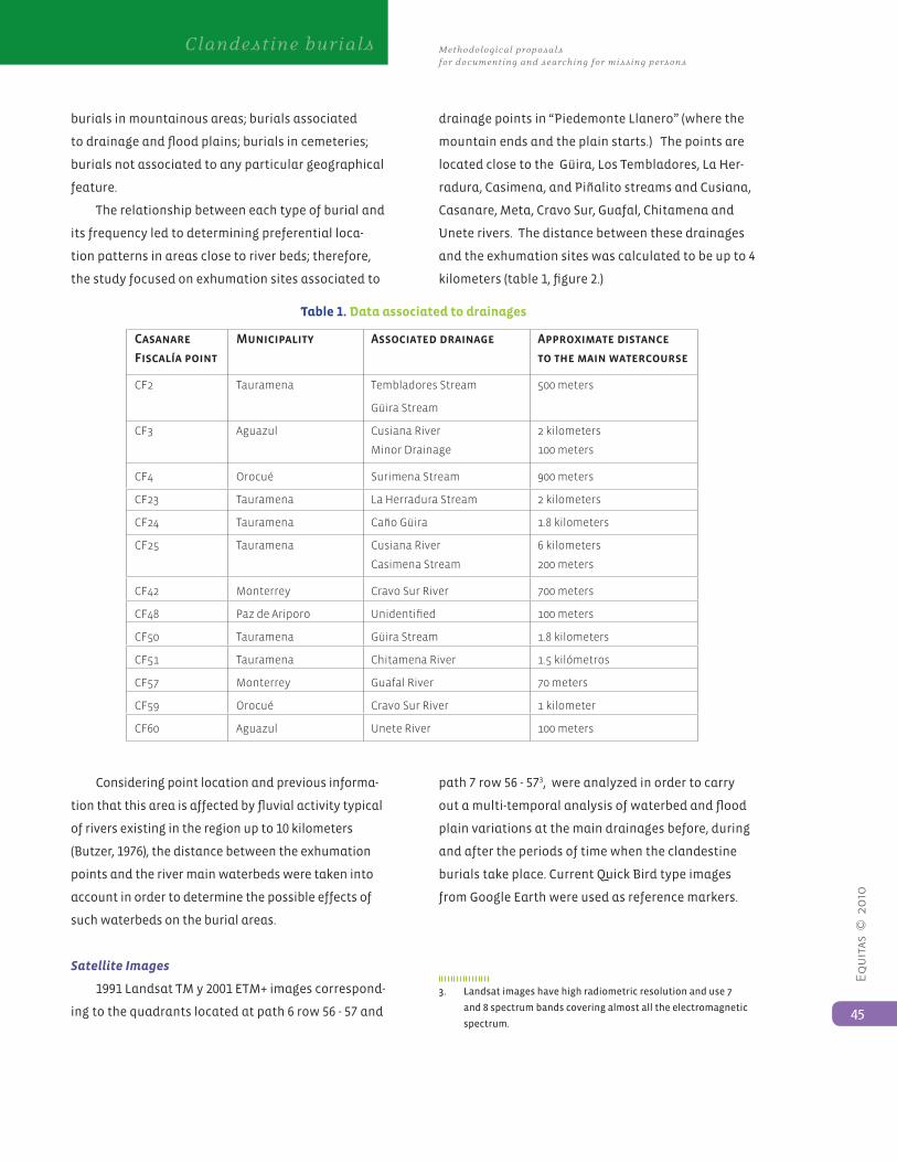
Equ
itas
© 2
010
45
Methodological proposals for documenting and searching for missing persons
Clandestine burials
burials in mountainous areas; burials associated
to drainage and flood plains; burials in cemeteries;
burials not associated to any particular geographical
feature.
The relationship between each type of burial and
its frequency led to determining preferential loca-
tion patterns in areas close to river beds; therefore,
the study focused on exhumation sites associated to
drainage points in “Piedemonte Llanero” (where the
mountain ends and the plain starts.) The points are
located close to the Güira, Los Tembladores, La Her-
radura, Casimena, and Piñalito streams and Cusiana,
Casanare, Meta, Cravo Sur, Guafal, Chitamena and
Unete rivers. The distance between these drainages
and the exhumation sites was calculated to be up to 4
kilometers (table 1, figure 2.)
Table 1. Data associated to drainages
Casanare
Fiscalía point
Municipality Associated drainage Approximate distance
to the main watercourse
CF2 Tauramena Tembladores Stream
Güira Stream
500 meters
CF3 Aguazul Cusiana River
Minor Drainage
2 kilometers
100 meters
CF4 Orocué Surimena Stream 900 meters
CF23 Tauramena La Herradura Stream 2 kilometers
CF24 Tauramena Caño Güira 1.8 kilometers
CF25 Tauramena Cusiana River
Casimena Stream
6 kilometers
200 meters
CF42 Monterrey Cravo Sur River 700 meters
CF48 Paz de Ariporo Unidentified 100 meters
CF50 Tauramena Güira Stream 1.8 kilometers
CF51 Tauramena Chitamena River 1.5 kilómetros
CF57 Monterrey Guafal River 70 meters
CF59 Orocué Cravo Sur River 1 kilometer
CF60 Aguazul Unete River 100 meters
Considering point location and previous informa-
tion that this area is affected by fluvial activity typical
of rivers existing in the region up to 10 kilometers
(Butzer, 1976), the distance between the exhumation
points and the river main waterbeds were taken into
account in order to determine the possible effects of
such waterbeds on the burial areas.
Satellite Images
1991 Landsat TM y 2001 ETM+ images correspond-
ing to the quadrants located at path 6 row 56 - 57 and
path 7 row 56 - 573, were analyzed in order to carry
out a multi-temporal analysis of waterbed and flood
plain variations at the main drainages before, during
and after the periods of time when the clandestine
burials take place. Current Quick Bird type images
from Google Earth were used as reference markers.
3. Landsatimageshavehighradiometricresolutionanduse7
and 8 spectrum bands covering almost all the electromagnetic
spectrum.
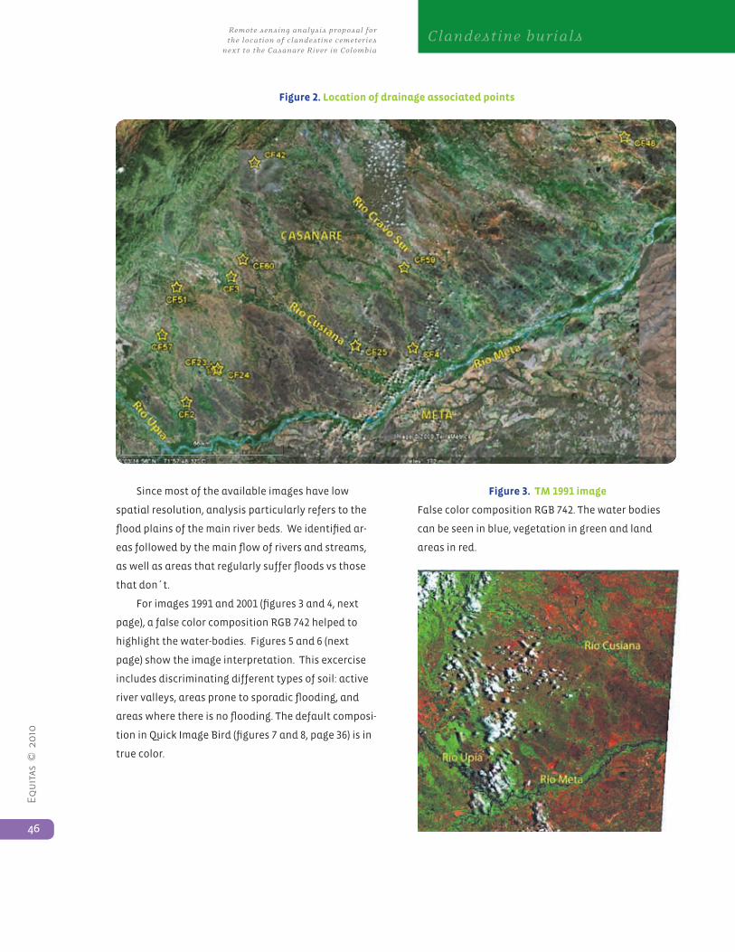
Equ
itas
© 2
010
46
Remote sensing analysis proposal for the location of clandestine cemeteries next to the Casanare River in Colombia
Clandestine burials
Since most of the available images have low
spatial resolution, analysis particularly refers to the
flood plains of the main river beds. We identified ar-
eas followed by the main flow of rivers and streams,
as well as areas that regularly suffer floods vs those
that don´t.
For images 1991 and 2001 (figures 3 and 4, next
page), a false color composition RGB 742 helped to
highlight the water-bodies. Figures 5 and 6 (next
page) show the image interpretation. This excercise
includes discriminating different types of soil: active
river valleys, areas prone to sporadic flooding, and
areas where there is no flooding. The default composi-
tion in Quick Image Bird (figures 7 and 8, page 36) is in
true color.
Figure 2. Location of drainage associated points
Figure 3. TM 1991 image
False color composition RGB 742. The water bodies
can be seen in blue, vegetation in green and land
areas in red.
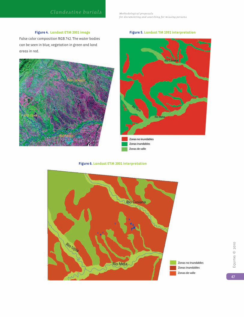
Equ
itas
© 2
010
47
Methodological proposals for documenting and searching for missing persons
Clandestine burials
Figure 4. Landsat ETM 2001 image
False color composition RGB 742. The water bodies
can be seen in blue, vegetation in green and land
areas in red.
Figure 5. Landsat TM 1991 interpretation
Figure 6. Landsat ETM 2001 interpretation
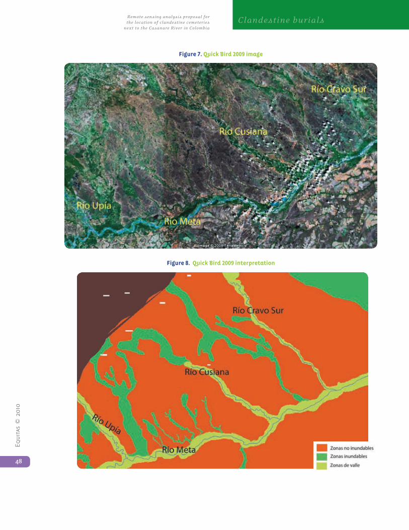
Equ
itas
© 2
010
48
Remote sensing analysis proposal for the location of clandestine cemeteries next to the Casanare River in Colombia
Clandestine burials
Figure 7. Quick Bird 2009 image
Figure 8. Quick Bird 2009 interpretation

Equ
itas
© 2
010
49
Methodological proposals for documenting and searching for missing persons
Clandestine burials
Aerial Photographs
Aerial photographs were used to improve the spatial
resolution of exhumation points near to rivers
Meta and Cusiana, to observe the local condition of
drainages, and, when possible, to carry out multi-
temporal analyses of landscape variations that could
be affecting the sites where there are clandestine
burials (figure 9.) The observations focused on
these two rivers because they were the ones that
presented the best material to be analyzed, and
their morphological characteristics are ideal for
establishing parameters applicable to the rest of the
drainages in the region. The scales used to work with
the images were 1:15000 to 1:30000, corresponding to
flights IGAC C2715, C2710, C2614, C2490, C2615.
Figure 9. Morphology variation of meanders and
flood plains. Esc. 1:20.000
Software
Erdas 9.0® software was used for the analysis and
interpretation of the material.
ResuLts
Geographical Characterization of the Target Area
The target area is located in the “Piedemonte
Llanero” sector, which is is a transitional area
between the Eastern mountain range and the
Eastern plains. This has a direct effect on fluvial
dynamics, producing a high energy system whwere
high, steep mountainous areas transform into a
system where energy must be dispersed throughout
the plains, forcing the riverbed to adopt new forms
of resulting in a meander and braid like system of
rivers.
The fluvial dynamics in the mentioned area is in
general, extremely rainy; this phenomenon is proven
by the large water gushes at the base of the moun-
tains. Some records show water flows between 40 and
150 m3 per second in Guayuriba river; from 40 to 1700
m3 per second in Guatiquía river; and from 390 to 860
m3 per second in Meta river, according to data from
the Institute for Hydrological, Meteorological and En-
vironment Studies (IDEAM – in Spanish.) The alluvial
force coming from the mountain range is deposited
mainly in the “piedemonte” mentioned above, and
this is why some water bodies raise their level causing
flooding and riverbed switching.
Moreover, the “Piedemonte Llanero” presents
different geo-morphological expressions caused by
geological factors and natural processes occurring
on the surface (Ingeominas, 2004.) These expressions
can be divided in three geo-morphological categories:
structural, fluvial (disected fans), and fluvial (flood
plains.)
From the climate perspective, the “Piedemonte
Llanero” is characterized by its 1500 to 2000 mm
annual rainfall, which makes it a high rainfall region.
There is a mono-modal regime with 7 or 8 month
periods, and the dominant savanna vegetation and
partially cloudy skies facilitate the transportation of
sediments and superficial substances.
dIsCussIon
As shown in Figure 2, exhumations in the Department
of Casanare have occurred mainly in areas close to
riverbeds found in the “Piedemonte Llanero”, a region
characterized for having meander like river systems
and greatly varied flood plains. These meander like
river systems are known for having a main riverbed
with minimum sinuosity of 1.5 meters and a great
capacity to transport fine sediment (i.e. silt) as well as
thick, heavy sediment (i.e. gravel, vegetable material),
Equ
itas
© 2
010
50
Remote sensing analysis proposal for the location of clandestine cemeteries next to the Casanare River in Colombia
Clandestine burials
according to the flow energy. In the river valleys there
are alluvial plains formed by deposited sediment
where currents readjust their course by carving it
out and re-depositing material. With time, meanders
migrate down the river and tend to increase sinuosity.
The maximum current speed occurs in the channels´
external part, thus producing higher erosion, and the
carved out material is re-deposited in the inner part of
the channel, thus producing pointed bars (Butzer, 1976.)
Through satellite image observation, the way
flood zones have decreased during the last 10 years
has been evident, making this area vulnerable to
erosion, particularly in heavy rain periods when the
areas closest to the bodies of water turn into sporadic
flood areas. The decrease of the flood area extension
could be due to climate changes or anthropic effects
such as the use of flood areas for crop farming, riv-
erbed control for agricultural purposes, or for gravel
exploitation, etc.
Sporadic flooding periods can affect the location
of clandestine burials in two fundamental aspects.
First, flooding can erase any type of superficial mark
indicating the existence of a grave; second, it can cause
significant variation in the landscape, particularly in
the riverbed shape, which can affect the interpretation
of reference points identified by witness testimony.
It is worth mentioning the following precisions
for future research: First, it is important that images
used to evaluate changes in landuse, if possible,
correspond to the same season of the year so
that rain regimes do not alter conditions that are
observed, like interpreting visible changes when it is
really a recurring phenomenom. It is also important
to take into account climatic phenomenoms such
as the “Niño”, which start with dry periods followed
by strong rains. Second, it is important to include
other sources of information such as archive, oral,
and archaeological references that can be cross-
referenced for more accurate interpretation.
Study Development Difficulties
1. Data Obtained from the Justice and Peace Unit
There are multiple factors able to induce errors
or lack of understanding related to the analyzed
information. First of all, the exact coordinates of
the locations where the exhumation took place
were not contained in the provided records. In other
cases, coordinates with minute and second values
greater than 60 or grades in decimal quantities were
observed, making it impossible to understand the
exact value referred to by the data. Secondly, there
was point repetition in the database, and some of
them were mutually incoherent; for example, points
CF2 and CF3 had the same coordinates as points CF56
and CF55 respectively, but some of the data, like the
proceedings date and the body description, differed.
Thirdly, inconsistencies were observed between the
given coordinates and the referred district or farm
for a single point when trying to locate the data on a
topographic map. These three factors reflect errors
in the database organization and in the standard
parameters used in exhumation records done by the
Justice and Peace Unit, making it impossible to have a
real estimate of the work carried out and a workable
data systematization to contribute to planning future
surveys or exhumations.
Moreover, the database lacks important informa-
tion. There is no information about the geo-reference
system used, the equipment utilized to collect data,
or its accurateness. There is no evidence that com-
plete information on the exhumation such as the
description of nearby infrastructure (houses, access
roads, etc.), objective distance to a body of water, ter-
rain conditions (flat, mountainous), and ground type,
is systematically documented and included in the
database for future analysis.
The available information about the exhuma-
tions carried out by the Justice and Peace Unit does
not lead to other observations on clandestine burial
Equ
itas
© 2
010
51
Methodological proposals for documenting and searching for missing persons
Clandestine burials
patterns in the department of Casanare. For that
reason, this study suggests:
• Having a standard geo-reference system, i.e.
establishing fixed facts for determining coordinates.
• Designing a detailed recording format for the
excavations to register clear, specific, and standard
data about burial characteristics (i.e. unifying
criteria for recording ground profiles.)
• Recording broader observations about the
landscape (i.e. access roads, infrastructure, etc.)
registering not only the location of other burial sites
but also allowing a greater understanding of the
armed actors’ modus operandi.
2. Lack of Tele-Detection Material
A more detailed analysis of a larger area would have
been possible with the interpretation of satellite
images of high spatial resolution such as Ikonos,
Quick Bird or Eros. Nevertheless, the scope of these
images is scarce in the target area. It is important
to complement and update aerial photographs, and
topographic cartography obtained at IGAC .
ConCLusIons
The data provided by the Justice and Peace Unit on
exhumations in the department of Casanare allow
us to establish that clandestine burials in this region
of the country clearly tend to be located in areas of
river marginal activity, particularly in flood plains.
This implies that fluvial dynamics, due to riverbed
morphology and flood plain variation, have great
effect over the landscape containing the burials. For
example, this study allowed us to observe variations
of up to 300 meters in the meanders’ width in periods
no longer than 10 years. Local variations of great
scope in this region make superficial events occurred
in short periods of time disappear due to the erosion-
deposit activity, particularly when they involve
small size modifications such as graves. However,
it is possible to suggest priority search areas in old
sedimentation areas that meanders have not reached
during the period of time analyzed.
Although detail and types of data on exhumed
graves varies in the records it is possible to establish
that in all cases, burials are superficial and small in
size since they contain 3 individuals at most. These
burial characteristics, plus the variation of the
ground surface in erosion-deposit areas, suggest a
scale problem which makes it impossible to locate
exact areas for clandestine burials using satellite
images and aerial photographs.
Although these methods do not help determine
places where burials could be found, remote sensors
proved to be vital tools to understand landscape and
observe its evolution through time. Cross referencing
this information helps interpret testimonies of
various actors more accurately.
It is not possible to determine if fluvial activity
is able to expose, erode or even transport bodies, as
there is no recording of burial conditions, such as the
exact depth and the type of soil at the place. Relevant
conclusions could be formulated based on a joint
analysis of the grave information, flow data, plus the
data on rain patterns in the region.
However, the way exhumations are currently
planned and executed, on an individual testimony
basis is not sustainable on a longterm situation.
The magnitude of the problem of missing persons in
conflict in Colombia, requires immediate attention
in order to document current findings, and carry out
analysis that will lead to predictive models when
testimonies are not available, and search teams have
to rely on archaeological methods to find clandestine
burials.
Based on this study, whenever remote sensing
information (satellite images and aerial photographs)
is available, tele-detection studies could become
a key element to cross reference testimonies, find
patterns and plan field work by prioritizing work
areas and determining other in situ survey methods,
Equ
itas
© 2
010
52
Remote sensing analysis proposal for the location of clandestine cemeteries next to the Casanare River in Colombia
Clandestine burials
such as the use of geophysical tools according to
terrain characteristics. This will guarantee that
exhumations will not follow individual graves, but
try to recover all graves that are in a specific area,
making human, economic and operational resources
more effective. Future research should consider
design project that includes georeferenced graves,
and potential burial sites through a geostatistic
perspective. This approximation could lead to a
model or predictive map of potential gravesites,
which will allow a better analysis of economic and
operational fieldwork and success in the search for
missing persons.
aCnoWLedgMents
We would like to thank the Exhumations Sub-
Unit of the Justice and Peace Unit of the National
Prosecutors Office for sharing their information for
this study. Also, the UNODC SIMCI II Project from
the United Nations Office in Colombia (Illegal Crops
Monitoring Integrated System - in Spanish) for
sharing their Landsat images with us. We received
generous comments to this work from Andres Guhl,
MSc in physical and environmental geography,
Elena Posada and Hector Mauricio Ramirez from the
CIAF - IGAC (Center for Research and Development
of Geographical Information - In Spanish), Orlando
Gonzalez, engineer at UNODC, and William Piñeros,
cadastral engineer.
RefeRenCes
Butzer, K. (1976) Geomorphology from the Earth.
Harper and Row. New York. 463 p.
INGEOMINAS (2004): Aspectos más relevantes de
la geología y la geomorfología del Piedemonte Llanero
de Colombia (Top Relevant Aspects of Colombian
Piedemonte Llanero’s Geology and Geo-morphology.)
Republic of Colombia, Ministry of Mines y Energy.
Bogota. 23p.
Kalácska M and Bell L (2006) Remote Sensing as a
Tool for the Detection of Clandestine Mass Graves. Ca-
nadian Society of Forensic Sciences Journal 39(1):1–13