5.8 hydrology and water quality · affect hydrology and water quality, the focus of the following...
TRANSCRIPT

City of Riverside General Plan and Supporting Documents EIR Section 5.8 – Hydrology and Water Quality
Certified November 207 Albert A. WEBB Associates 5.8-1
5.8 HYDROLOGY AND WATER QUALITY
The six components of the project analyzed herein are:
1) Adoption and implementation of the General Plan; 2) Adoption and implementation of the revised Zoning Code;3) Adoption and implementation of the revised Subdivision Code;4) Adoption and implementation of amendment to the Noise Code; 5) Adoption and implementation of the Magnolia Avenue Specific Plan (MASP); and6) Adoption and implementation of the Citywide Design and Sign Guidelines.
Of the six project components, the Zoning Code, Subdivision Code, Noise Code Amendment, Magnolia Avenue Specific Plan and the Citywide Design and Sign Guidelines address site planning, building design and community aesthetics, rather than physical changes to the land, and are thus not considered to have direct or indirect impacts related to hydrology and water quality and will not be analyzed further in this Section. Because adoption and implementation of the General Plan will dictate development patterns, which will in turn affect land uses which then affect hydrology and water quality, the focus of the following analysis will be for the General Plan component of the project. The impacts related to the adoption and implementation of the General Plan will be addressed herein.
The Hydrology and Water Quality Section of this EIR has been changed from the previously circulated EIR. In addition to the overall changes listed in the Project Description Section of this EIR, background information and analysis was added for the Planning Area. Information for all topics within this Section was verified and updated as necessary.
This analysis focuses on the project’s six components listed above and the subsequent potential impacts related to hydrology and water quality. Since an initial study was not prepared with the issuance of the Notice of Preparation, the focus of the following discussion is related to the potential impacts to water quality, groundwater supplies, drainage patterns, runoff, stormwater drainage systems, 100-year flood hazards areas, and inundation associated with the six components of the proposed project (listed above), as these actions have the potential to affect hydrology and water quality.
In addition to other reference documents, the following references were used in the preparation of this section of the EIR:
Santa Ana Regional Water Quality Control Board, date accessed: April 13, 2007, from http://www.waterboards.ca.gov/santaana/
Santa Ana Regional Water Quality Control Board, 2006 CWA Section 303 (d) List of Water Quality Limited Segments and 2006 CWA Section 303 (d) List of Water Quality Limited Segments Being Addressed by USEPA Approved TMDLS, date accessed: April 18, 2007, from http://www.waterboards.ca.gov/santaana/
Riverside County Flood Control and Water Conservation District, date accessed, April 13, 2007, from http://www.floodcontrol.co.riverside.ca.us/districtsite/default.asp

City of Riverside General Plan and Supporting Documents EIR Section 5.8 – Hydrology and Water Quality
Certified November 2007 Albert A. WEBB Associates 5.8-2
Santa Ana Regional Water Quality Control Board, Watershed Management Initiative Chapter, revised May 2004.
Riverside County Flood Control and Water Conservation District, Santa Ana Regional Drainage Area Management Plan, July 2005.
California Stormwater Quality Association, January 2003, Stormwater Best Management Practice Handbook for New Development and Redevelopment, prepared by Camp Dresser & McKee and Larry Walker Associates.
Riverside County Flood Control and Water Conservation District, Riverside County Stormwater Quality Best Management Practice Design Handbook. July 21, 2006.
City of Riverside Public Utilities Department, 2005, Urban Water Management Plan.
Western Municipal Water District. 2005, Urban Water Management Plan, (Available at http://www.wmwd.com/pdfs/UrbanWaterMgtPlan.pdf).
National Flood Insurance Program, Flood Insurance Rate Map-City of Riverside, Community Panel # 060260-0005 B, August 2005.
California Department of Water Resources, Division of Safety of Dams, Dams Within the Jurisdiction of the State of California, accessed 4/29/07. (Available at http://damsafety.water.ca.gov)
City of Riverside, Santa Ana River Task Force Report, January 2004.
Setting
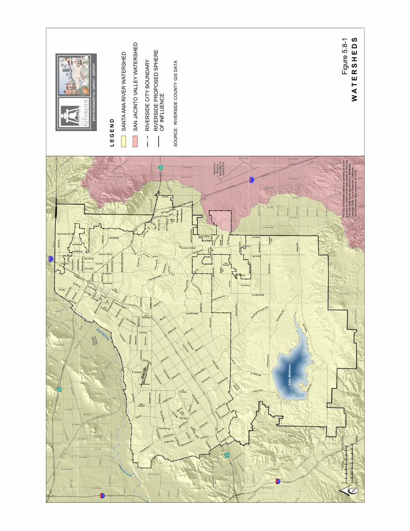
Surface Hydrology The City of Riverside is located within the Santa Ana Region (Region 8) of the California Regional Water Quality Control Board (RWQCB). The Planning Area (City and Sphere Area) is located within the RWQCB Middle Santa Ana River Watershed Management Area and in the Santa Ana Hydrologic Unit. For most of the Planning Area, surface drainage generally flows in a northerly direction into the Santa Ana River. There are eleven principal drainage areas for which Master Drainage Plans have been completed (see Figure 5.16-1), in the City of Riverside, ten of which eventually flow into the Santa Ana River. These main drainage areas are: University, Box Springs, Central Riverside, Monroe, La Sierra, Southwest Riverside, Home Gardens, Mead Valley, Moreno Valley West End, and Norco.
There is a small portion of the eastern edge of the Orangecrest Neighborhood, in the Perris Valley drainage area, that is located in the San Jacinto Watershed, instead of the Santa Ana River Watershed. Figure 5.8-1, Watersheds depicts the boundary between the Santa Ana Watershed and San Jacinto Watershed.
WoodRd
VictoriaAve
TylerSt
Adams St
MagnoliaAve
ElSobranteRd
DaySt
Monroe St
CajalcoRd
JurupaAve
WatkinsDr
Center St
La Sierra Ave
KrameriaAve
Nandina
Ave
BartonSt
CentralAve
SierraAve
LaSierraAve
La Sierra Av
e
OverlookPk wy
ElSobranteRd
MarySt
Gentian
Ave
RobertsRd
Proposed
"B" Dr
CajalcoRd
RansomRd
CanyonCrest
Dr
Mt.VernonAve
RiverwalkPkwy
SantaA
naRiver
Sant
aAnaRiver
LakeMathews
ElCerritoDr
PorterAve
MariposaAve
IrisAve
DauchyAve
ChicagoAve
BartonRd
Mitch
ell Ave
NorwoodAve
CampbellAve
JonesAve
Cook Ave
Sierra V
istaSt
HarrisonSt
Golden Ave
CollettAve
FremontSt
PierceSt Schuyler
Ave
ViewLn
Golden S
tar Ave
GramercyPl
SpruceSt
Jefferson
St
Third
St
LincolnAve
CypressAve
Pierce
St
Markham
St
BradleySt
HoleAve
FourteenthSt
ColumbiaAve
GrandAve
Polk S
t
Brockton Ave
Challen
Ave
DeweyAve
LindenSt
UniversityAve
Hi
llside
Ave
HarrisonSt
DufferinAve
"A"St
Orchard
CottonwoodAve
Sycamore Canyon
Blvd
Victoria Ave
RamonaDr
KansasAve
CanyonCrestDr
IowaAve
AtlantaSt
McAllisterSt
MissionGrovePkwy
John
F.Kennedy
Dr
SierraRidge
Dr River
RunDr
Dan
Kipper Dr
ViaVistaDr
Com
munityDr
Grove
Dr
RustinAve
MarlboroughAve
MichiganSt
MulberrySt
PhilbinAve
PalmAve
Orange
St
Van Buren Blvd
ChicagoAve
RiversideAve
Orange
TerracePkwy
RiveraS
t
Jackso
n St
RutlandAve
StrongSt
Golden Ave
FillmoreSt
BlaineSt
Maude St
Arlington
Ave
WellsAve
CridgeSt
CenturyAve
CentralAve
Loch
moo r
First St
MarketSt
Tenth
St
LimeSt
MissionInnAve
Olivewo
odAve
Oleander
Ave
Merrill Ave
EagleRidgeDr
NorthgateSt
Proposed
"A"Dr
Isle
Fair
Box Spr ings
MainS
t
WashingtonSt
LaCad
enaDr
ColoradoAve
Trautwein
Rd
Buchanan St
MadisonSt
AlessandroBlvd
Fifth
St
CaliforniaAve
JurupaAve
ColeAve
McAllister St
CentralAve
Alessand
ro Blvd
VanBuren
Blvd
Blvd
MartinLutherKingBlvd
Tyler St
IndianaAve
MainSt
Citrus
St
CajalcoRd
ArlingtonAve
WashingtonSt
ArlingtonAve
Mo
ckin
gbirdCan
yonRd
VanBurenBlvd
ColumbiaAve
Palmyrita
Ave
IowaAve
Magno
liaAve
Bandini Ave
HermosaDr
§̈a#
§̈a#
% &h (
% &h (
?z
?z
?Æ
Flabob
Airport
MarchAir
Reserve
Base/March
InlandPort
Riverside
MunicipalAirport
A St
MainSt
VanBurenBlvd
JurupaRd
PedleyRd
ClarkSt
BainSt
GraniteHillDr
PigeonPassRd
BrownSt
6thSt
C
LakeMathewsDr
58thSt
MackSt
I
SampsonAve
Reche Canyon Rd
GrahamSt
Old Elsino
re Rd
EtiwandaAve
GavilanRd
RubidouxBlvd
HeacockSt
tonAve
Martin
St
56thSt
WinevilleAve
Camin
oReal
Parkrid
geAve
StevenDr
PromenadeAve
E
agleCa
nyonRoad
EastridgeAve
LimoniteAve
HiddenValley
Pkwy
68thSt
A
IronwoodAve
BellegraveSt
hillPky
SeatonAve
PostRd
AgateSt
Van Buren B
lvd
LukensLn
Clay St
Rimpau Ave
Limonite
Ave
34thSt
IndianaAve
MarlattSt
ElsworthSt
FourthSt
FelsparSt
CrestaRd
Armstrong
Rd
GalenaSt
J
Box
Springs
Rd
PeraltaPl
PacificAv
e
TemescalCanyonRd
BeachSt
20thSt
Market St
G
AvonSt
WebsterAve
OrangeAve
FrederickSt
NeilSt
RutileSt
DeckerRdNuevoRd
RiderSt
MissionBlvd
AlexanderSt
CaliforniaAve
NuC
Fifth
St
Cajalco
Rd
DaySt
Markham
St
Nandina
Ave
MagnoliaAve
McKinleySt
NorcoHil
lsRd
CaliforniaAve
Sunn
ymead
Ranch P
k y
LEGEND
WATERSHEDS
Figu
re5.
8-1
SAN
JAC
INTO
VALL
EYW
ATE
RSH
ED
SAN
TAA
NA
RIV
ER
WAT
ERSH
ED
RIV
ERSI
DE
PR
OP
OS
EDSP
HE
RE
OF
INFL
UEN
CE
RIV
ERSI
DE
CIT
YBO
UN
DAR
Y
SOU
RC
E:R
IVE
RS
IDE
CO
UN
TYG
ISD
ATA
The
City
ofR
iver
side
mak
esno
war
rant
yas
toth
eac
cura
cyor
cont
ento
fthe
data
show
non
this
map
.Th
ism
apsh
alln
otbe
repr
oduc
edor
dist
ribut
ed.
Cop
yrig
ht20
06,C
ityof
Riv
ersi
de,C
alifo
rnia
.C
ityof
Riv
ersi
deda
tacu
rrent
to12
-15-
06.
01
2M
iles
05,
000
10,0
00Fe
et

City of Riverside General Plan and Supporting Documents EIR Section 5.8 – Hydrology and Water Quality
Certified November 2007 Albert A. WEBB Associates 5.8-4
The Santa Ana River flows from the San Bernardino Mountains to the Pacific Ocean for over 100 miles. The Santa Ana River is the “receiving water” for over 2,700 square miles covering portions of San Bernardino, Riverside and Orange Counties. Reach 3 of the Santa Ana River, which is the receiving water for the majority of the Planning Area, is listed as an impaired water body for pathogens on the 2006 CWA Section 303(d) List of Water Quality Limited Segments Being Addressed by USEPA Approved TMDLS.
A number of arroyos that are tributary to the Santa Ana River traverse the Planning Area; portions are in their natural state, portions are disturbed by human activities, and portions are piped under the urbanized areas of the City before they reach the Santa Ana River. The major arroyos identified on General Plan Figure OS-4 include, from northeast to southwest: Springbrook Wash, Tequesquite Arroyo, Alessandro Arroyo, Prenda Arroyo, Woodcrest Arroyo, and Mockingbird Canyon. These are the major arroyos as defined and protected in the City’s Grading Code, Title 17. Other minor arroyos also exist in the Planning Area. Some of these arroyos are currently crossed by roads, at-grade or via various types of bridges. Crossings which are proposed as part of the General Plan Master Plan of Roadways that will cross natural portions of these named arroyos include: Proposed Drive ‘A’, which will cross Prenda Arroyo, Proposed Drive ‘B’, which may cross tributaries of both Prenda and Alessandro Arroyos, and the connection of Overlook Parkway across the Alessandro Arroyo. Although more disturbed in its present state, Springbrook Wash will be crossed by Mt. Vernon Avenue within the County portion of the Planning Area.
The area of the City that is located in the San Jacinto Watershed is drained by the Perris Valley Storm Drain, which then flows into the San Jacinto River. The San Jacinto River drains the area from the San Jacinto Mountains to Canyon Lake, and then to Lake Elsinore. Canyon Lake and Lake Elsinore are listed separately as impaired water bodies collectively for nutrients and organic enrichment/low dissolved oxygen on the 2006 CWA Section 303(d) List of Water Quality Limited Segments Being Addressed by USEPA Approved TMDLS. Pathogens, PCBs, and unknown toxicity are identified for these two water bodies on the 2006 CWA Section 303(d) List of Water Quality Limited Segments.
The Riverside County Flood Control and Water Conservation District (RCFCWCD) is responsible for regional flood control and drainage facilities. The City maintains local facilities that tie into RCFCWCD regional system. Local drainage facilities, consisting mostly of underground closed conduits and storm drains located primarily in developed portions of the Planning Area, collect stormwater and convey it to regional facilities, including the Santa Ana River.
Groundwater Resources
Local groundwater basins are recharged from natural runoff, treated wastewater, and imported water. Runoff from local rainfall is the main source of recharge for the smaller basins. In 2005, the City met 97 percent of its water needs from underground resources, while receiving only 3 percent from the Western Municipal Water District (WMWD). The annual production by all extractors of the groundwater basins that support the City of Riverside is roughly 260,932 acre-feet per year.

City of Riverside General Plan and Supporting Documents EIR Section 5.8 – Hydrology and Water Quality
Certified November 2007 Albert A. WEBB Associates 5.8-5
Water resources throughout Riverside County are sustained by significant groundwater basins, which are used as reservoirs to store water during wet years and to supply stored water in dry years. Groundwater conditions in these basins are influenced by natural hydrologic conditions such as percolation of precipitation, groundwater seepage and ephemeral stream flow from the nine arroyos that traverse the Planning Area. The City has water supply wells in the Bunker Hill, Rialto-Colton, Riverside North, Riverside South and Arlington groundwater basins most of which are located outside of the Planning Area. The City extracts domestic water from the Bunker Hill, Riverside North, and Riverside South basins through 51 wells operated by Riverside Public Utilities (RPU) and the Gage Canal Company. Water for domestic use is not extracted from the Arlington and Rialto-Colton basins because of poor water quality and lack of transmission lines.
Inundation
Most of the annual rainfall in the region occurs in the winter. Flooding in the City of Riverside could result from intense storms or as the result of dam failure. The U.S. Army Corps of Engineers is responsible for dam safety and conducting routine inspections of Federal dams, however, most of the dams within the Planning Area fall under the jurisdiction of the State Department of Water Resources Division of Safety of Dams. Federal Emergency Management Agency (FEMA) Flood Insurance Rate Maps (FIRMs) show that portions of the Planning Area fall within the 100-year flood zone. Areas subject to flooding during a 100-year storm event are depicted in Figure 5.8-2, Flood Hazard Areas. Flood hazard risks are greatest in the vicinity of channels, creeks, streams and watercourses. This includes the Santa Ana River and several dams, including Sycamore Canyon Dam, Box Springs Dam, Mary Street Dam, Alessandro Dam, Prenda Dam, Woodcrest Dam, Mockingbird Canyon Dam, Harrison Dam, and Lake Mathews Dam. With the exception of the Mockingbird Canyon, and Lake Mathews Dam, all dams within the study area are owned by Riverside County Flood Control and Water Conservation District, according to the State Department of Water Resources. Mockingbird Canyon Dam is owned and maintained by the City, while Lake Mathews is owned by Metropolitan Water District. The State Division of Safety of Dams inspects all dams under its jurisdiction.
Due to the City’s distance from the ocean, there is no foreseeable risk of tsunami (tidal wave) inundation. Seiches are oscillations in enclosed bodies of water caused by seismic waves. Existing development is subject to hazards from seiches in reservoirs such as Lake Mathews and Lake Evans and other small water bodies. Mudflows associated with erosion may also occur in portions of the community.

WoodRd
VictoriaAve
TylerSt
Adams St
MagnoliaAve
ElSobranteRd
DaySt
Monroe St
CajalcoRd
JurupaAve
WatkinsDr
Center St
La Sierra Ave
KrameriaAve
NandinaAve
BartonSt
CentralAve
SierraAve
LaSierraAve
La Sierra Av
e
OverlookPk wy
ElSobranteRd
MarySt
Gentian
Ave
RobertsRd
Proposed
"B" Dr
CajalcoRd
RansomRd
CanyonCrest
Dr
Mt.VernonAve
RiverwalkPkwy
SantaA
naRiver
Sant
aAnaRiver
LakeMathews
ElCerritoDr
PorterAve
MariposaAve
IrisAve
DauchyAve
ChicagoAve
BartonRd
Mitch
ellAve
NorwoodAve
Cam
pbellAve
JonesAve
Cook Ave
Sierra V
istaSt
HarrisonSt
Golden Ave
CollettAve
FremontSt
PierceSt Schuyler
Ave
ViewLn
Golden S
tar Ave
GramercyPl
SpruceSt
Jefferson
St
Third
St
LincolnAve
CypressAve
Pierce
St
Markham
St
BradleySt
HoleAve
FourteenthSt
ColumbiaAve
GrandAve
Polk S
t
Brockton Ave
Challen
Ave
DeweyAve
LindenSt
UniversityAve
Hi
llside
Ave
HarrisonSt
DufferinAve
"A"St
Orchard
CottonwoodAve
Sycamore Canyon
Blvd
Victoria Ave
RamonaDr
KansasAve
CanyonCrestDr
IowaAve
AtlantaSt
McAllisterSt
MissionGrovePkwy
John
F.Kennedy
Dr
SierraRidgeDr River
RunDr
DanKipper Dr
ViaVistaDr
Com
munityDr
Grove
Dr
RustinAve
MarlboroughAve
MichiganSt
MulberrySt
PhilbinAve
PalmAve
Orange
St
Van Buren Blvd
ChicagoAve
RiversideAve
Orange
TerracePkwy
RiveraS
t
Jackso
n St
RutlandAve
StrongSt
Golden Ave
FillmoreSt
BlaineSt
Maude St
Arlington
Ave
WellsAve
CridgeSt
CenturyAve
CentralAve
Loch
moo r
First St
MarketSt
Tenth
St
LimeSt
MissionInnAve
Olivewo
odAve
Oleander
Ave
Merrill Ave
EagleRidgeDr
NorthgateSt
Proposed
"A"Dr
Isle
Fair
Box Spr ings
MainS
t
WashingtonSt
LaCad
enaDr
ColoradoAve
Trautwein
Rd
Buchanan St
MadisonSt
AlessandroBlvd
Fifth
St
CaliforniaAve
JurupaAve
ColeAve
McAlliste
r St
CentralAve
Alessand
ro Blvd
VanBurenBlvd
Blvd
MartinLutherKingBlvd
Tyler St
IndianaAve
MainSt
Citrus
St
CajalcoRd
ArlingtonAve
WashingtonSt
ArlingtonAve
Mo
ckin
gbirdCan
yonRd
VanBurenBlvd
ColumbiaAve
PalmyritaAve
IowaAve
Magno
liaAve
Bandini Ave
HermosaDr
§̈a#
§̈a#
% &h (
% &h (
?z
?z
?Æ
Flabob
Airport
MarchAir
Reserve
Base/March
InlandPort
Riverside
MunicipalAirport
A St
MainSt
VanBurenBlvd
JurupaRd
PedleyRd
ClarkSt
BainSt
GraniteHillDr
PigeonPassRd
BrownSt
6thSt
C
LakeMathewsDr
58thSt
MackSt
SampsonAve
Reche Canyon Rd
GrahamSt
Old Elsino
re Rd
EtiwandaAve
GavilanRd
RubidouxBlvd
HeacockSt
tonAve
Martin
St
56thSt
WinevilleAve
Camin
oReal
Parkrid
geAve
StevenDr
PromenadeAve
E
agleCa
nyonRo
ad
EastridgeAve
LimoniteAve
HiddenValley
Pkwy
68thSt
A
IronwoodAve
BellegraveSt
thillPky
SeatonAve
PostRd
AgateSt
Van Buren B
lvd
LukensLn
Clay St
Rimpau Ave
Limonite
Ave
34thSt
IndianaAve
MarlattSt
ElsworthSt
FourthSt
FelsparSt
CrestaRd
ArmstrongRd
GalenaSt
J
BoxSprings
Rd
PeraltaPl
PacificAv
e
TemescalCanyonRd
BeachSt
20thSt
Market St
G
AvonSt
WebsterAve
OrangeAve
FrederickSt
NeilSt
RutileSt
DeckerRdNuevoRd
RiderSt
MissionBlvd
AlexanderSt
CaliforniaAve
NuC
Fifth
St
CajalcoRd
DaySt
Markham
St
NandinaAve
MagnoliaAve
McKinleySt
NorcoHil
lsRd
CaliforniaAve
Sunn
ymead
Ranch P
k y
364
96
42
5
15
107
18
32
5
10
127
15
412
240
20
25
6448
364
60
392
37
20
60110
45
60
70
30
500
208150
120
140
80
84
10
30
48
80
53
78112
35
190
180
160
48
15
40
19
18
80
13
68
54
18
40
30
288
2345
9020
20
30
30
30
40
364
412
96112
3040
70
37
FLOOD
HAZARDAREAS
Figu
re5.
8-2
01
2M
iles
05,
000
10,0
00Fe
et
"XX
"E
LAP
SE
DT
IME
INM
INU
TE
SF
RO
MD
AM
FA
ILU
RE
TO
AR
RIV
AL
OF
"FIR
ST
WA
TE
R."
### ####
NO
TE:T
HE
AREA
SO
FIN
UN
DAT
ION
FRO
MFL
OO
DIN
GAN
DFR
OM
DAM
FAIL
UR
EH
AVE
BEEN
DER
IVED
FRO
MM
APS
OF
VAR
IOU
SSC
ALES
,AN
DAR
EO
NLY
APPR
OXI
MAT
ELY
LOC
ATED
ON
THIS
PLAT
E.FO
RM
OR
EPR
ECIS
ELO
CAT
ION
STH
ER
EAD
ERSH
OU
LDC
ON
SULT
THE
STAT
EAP
PRO
VED
INU
ND
ATIO
NM
APS
AND
THE
FED
ERAL
INSU
RAN
CE
RAT
EM
APS
.
DAM
INU
ND
ATIO
NAR
EAS
ARE
BASE
DO
NTH
EAS
SUM
PTIO
NO
FIN
STA
NTA
NEO
US
FAIL
UR
EO
FTH
ED
AMW
ITH
THE
RES
ERVO
IRFU
LLTO
CA
PAC
ITY.
THE
AREA
SHO
WN
ISTH
AT
WH
ICH
WO
ULD
BEIN
UN
DAT
EDR
EGAR
DLE
SSO
FD
EPTH
OF
WAT
ERO
RVE
LOC
ITY
OF
FLO
W.
SOU
RC
E:FL
OO
DIN
UN
DAT
ION
DAT
AFR
OM
U.S
.G.S
.FLO
OD
HAZ
ARD
SM
AP(1
974)
,CO
RPS
OF
ENG
INEE
RS
(196
9)AN
DR
IVER
SID
EC
OU
NTY
FLO
OD
CO
NTR
OL
AND
WAT
ERC
ON
SER
VATI
ON
DIS
TRIC
TFL
OO
DH
AZAR
DS
MAP
S.
RIV
ERSI
DE
PR
OPO
SED
SPH
ER
EO
FIN
FLU
EN
CE
RIV
ERSI
DE
CIT
YBO
UN
DA
RY
FLOODHAZARDAREAS
DAM
INUNDATIO
NAREAS
100-
YEA
RFL
OO
DZO
NE
500-
YEA
RFL
OO
DZO
NE
LEGEND
SYC
AMO
RE
CAN
YO
ND
AM
BOX
SPR
ING
SD
AM
PRE
ND
AD
AMW
OO
DC
RE
ST
DAM
MAR
YS
TD
AM
HAR
RIS
ON
DA
MM
OC
KIN
GBI
RD
CAN
YON
DAM
#AL
ESSA
ND
RO
DAM
The
City
ofR
iver
side
mak
esno
war
rant
yas
toth
eac
cura
cyor
cont
ento
fthe
data
show
non
this
map
.Th
ism
apsh
alln
otbe
repr
oduc
edor
dist
ribut
ed.
Cop
yrig
ht20
06,C
ityof
Riv
ersi
de,C
alifo
rnia
.C
ityof
Riv
ersi
deda
tacu
rren
tto
12-1
5-06
.
LAKE
MAT
HEW
SD
AM
(FO
RM
ERLY
CA
JALC
OD
AM
)#

City of Riverside General Plan and Supporting Documents EIR Section 5.8 – Hydrology and Water Quality
Certified November 2007 Albert A. WEBB Associates 5.8-7
Thresholds of Significance
The City of Riverside has not established local CEQA significance thresholds as described in Section 15064.7 of the State CEQA Guidelines. Therefore, significance determinations utilized in this Section are based on Appendix G of the CEQA Guidelines. A significant impact will occur if implementation of the Project:
violates any water quality standards or waste discharge requirements or otherwise substantially degrade water quality;
substantially depletes groundwater supplies or interfere substantially with groundwater recharge such that there would be a net deficit in aquifer volume or a lowering of the local groundwater table level;
substantially alters the existing drainage patterns in the City, including through the alteration of the course of a stream or river in a manner which would result in substantial flooding, erosion or siltation on- or off-site;
creates or contributes runoff water which would exceed the capacity of existing or planned stormwater drainage systems, provide substantial additional sources of polluted runoff, or otherwise substantially degrade water quality;
places housing or structures within a 100-year flood hazard area, as mapped on a Federal Flood Hazard Boundary or Flood Insurance Rate Map or other flood hazard delineation map which would impede or redirect flood flows;
exposes people or structures to a significant risk of loss, injury, or death involving flooding, including flooding as a result of the failure of a levee or dam; or
subjects people or structures to inundation of seiche, tsunami or mudflow.
Related Regulations
FederalIn 1972, the Federal Water Pollution Control Act (Clean Water Act) was amended to prohibit the discharge of pollutants to waters of the United States unless the discharge is in compliance with a National Pollutant Discharge Elimination System (NPDES) permit. The Clean Water Act focused on tracking point sources, primarily from wastewater treatment facilities and industrial waste dischargers, and required implementation of control measures to minimize pollutant discharges. The Clean Water Act was amended again in 1987, adding Section 402(p), to provide a framework for regulating municipal and industrial storm water discharges. In November 1990, the U.S. Environmental Protection Agency (USEPA) published final regulations that establish application requirements for specific categories of industries, including construction projects that encompass greater than or equal to 5 acres of land. The Phase II Rule became final in December 1999, expanding regulated construction sites to those greater than or equal to 1 acre. The regulations require that storm water and non-storm water runoff associated with construction
City of Riverside General Plan and Supporting Documents EIR Section 5.8 – Hydrology and Water Quality
Certified November 2007 Albert A. WEBB Associates 5.8-8
activity, which discharges either directly to surface waters or indirectly through municipal separate storm sewer systems (MS4s), must be regulated by an NPDES permit.
The Federal Clean Water Act (CWA) requires all states to conduct water quality assessments of their water resources to identify water bodies that do not meet water quality standards. The water bodies that do not meet water quality standards are placed on a list of impaired waters pursuant to the requirements of Section 303(d) of the CWA. As stated above, the majority of the Planning Area drains to the Santa Ana River, Reach 3 that is listed on the 303(d) list as impaired for pathogens. A small area of the eastern part of the City is within the San Jacinto Watershed. Although San Jacinto River reach that would drain this area is not listed on the 303(d) list, the ultimate receiving water bodies of Canyon Lake and Lake Elsinore are on the 303(d) list. Canyon Lake is impaired for nutrients and pathogens. Lake Elsinore is listed impaired for nutrients, organics, low dissolved oxygen, sediment/siltation and unknown toxicity.
State
In the State of California, the State Water Resources Control Board and nine Regional Water Quality Control Boards (RWQCB) are responsible for implementing the Clean Water Act (CWA) and the State Porter Cologne Water Quality Control Act.
The Porter-Cologne Water Quality Control Act Section 13000 directs each Regional Water Quality Control Board (RWQCB) to develop a Water Quality Control Plan (Basin Plan) for all areas within its region. The Basin Plan is the basis for each RWQCB’s regulatory programs. The City of Riverside is located within the purview of the Santa Ana RWQCB (Region 8), and must comply with applicable elements of the region’s Basin Plan, as well as the Porter-Cologne Water Quality Control Act. The beneficial uses of the Planning Area’s receiving waters are listed below in Table 5.8-A, Beneficial Uses of Receiving Waters.

City of Riverside General Plan and Supporting Documents EIR Section 5.8 – Hydrology and Water Quality
Certified November 2007 Albert A. WEBB Associates 5.8-9
Table 5.8-A Beneficial Uses of Receiving Waters
Water Body Beneficial Uses Santa Ana River Reach 3 AGR, GWR, REC1, REC2, WARM, WILD, RARE
Lake Elsinore REC 1, REC 2, WARM, WILD
Canyon Lake AGR, GWR, REC1, REC2, WARM, WILD, MUN
San Jacinto River: Reaches 1, 2, & 3 MUN, AGR, GWR, REC1, REC2, WARM, WILD
Perris North – Groundwater Subbasin AGR, MUN, IND, PROC
Definitions AGR Waters are used for farming, horticulture or ranching. Uses may include, but are not limited to, irrigation,
stock watering, and support of vegetation for range grazing.
GWR Groundwater recharge waters, used for natural or artificial recharge of groundwater for purposes that may include future extraction, maintaining water quality, or halting saltwater intrusion in freshwater aquifers.
MUN Waters used for community, military, municipal, or individual water supply systems. Uses may also include drinking water supply.
IND Waters for industrial service supply. These uses do not depend primarily upon water quality, and may include mining, cooling water supply, hydraulic conveyance, gravel washing, fire protection, and oil well repressurization.
PROC Waters for industrial process supply. Uses are for industrial activities that are dependent upon water quality. Uses may include process water supply and all uses of water related to product manufacture or food preparation.
REC1 Water contact recreation waters, used for recreational activities involving body contact with water where ingestion of water is reasonably possible. Uses may include swimming, wading, water-skiing, skin and scuba diving, surfing, whitewater activities, fishing, and use of natural hot springs.
REC2 Non-contact water recreation waters, used for recreational activities involving proximity to water, but not normally involving body contact with water where ingestion of water would be reasonably possible. These uses may include picnicking, sunbathing, hiking, beachcombing, camping, boating, sightseeing, and aesthetic enjoyment in conjunction of the above activities.
WARM Warm freshwater habitat waters support warm water ecosystems that may include preservation and enhancement of aquatic habitats, vegetation, fish and wildlife, including invertebrates.
WILD Wildlife habitat waters support wildlife habitats that may include the preservation and enhancement of vegetation and prey species used by waterfowl and other wildlife.
The Santa Ana RWQCB administers the NPDES permit program regulating storm water from construction activities for projects greater than one acre in size. In order to meet its requirements under the NPDES permit program, the City must ensure the development within its jurisdiction obtains coverage under the General Construction Permit (Order No. 99-08-DWQ), a Waste

City of Riverside General Plan and Supporting Documents EIR Section 5.8 – Hydrology and Water Quality
Certified November 2007 Albert A. WEBB Associates 5.8-10
Discharge Identification Number (WDID) must be obtained, and an effective site-specific Storm Water Pollution Prevention Plan (SWPPP) developed. The SWPPP must identify potential on-site pollutants, identify and implement an effective combination of erosion control and sediment control measures to reduce or eliminate discharge of pollutants to surface water from storm water and non-storm water discharges. Best management practices (BMPs) described in the SWPPP must meet the Best Available Technology and Best Conventional Pollutant Control Technology (BAT/BCT) performance standard.
For specific projects, storm water best management practices (BMPs) to be implemented during construction and grading, as well as post-construction BMPs, will be outlined in the SWPPP prepared for the proposed project. Examples of BMPs include: detention basins for capture and containment of sediments, use of silt fencing, sandbags, or straw bales to control runoff, and identification of emergency procedures in case of hazardous materials spills. The City of Riverside is responsible for requiring project proponents to obtain a construction NPDES permit prior to site disturbance.
Specific industrial projects are subject to the Industrial Storm Water General Industrial Permit (Order 97-03-DWQ) is an NPDES permit that regulates discharges associated with 10 broad categories of industrial activities. The General Industrial Permit requires the implementation of management measures that will achieve the performance standard of best available technology economically achievable (BAT) and best conventional pollutant control technology (BCT). The General Industrial Permit also requires the development of a SWPPP and a monitoring plan.Through the SWPPP, sources of pollutants are to be identified and the means to manage the sources to reduce storm water pollution are described. The Industrial SWPPPs are different from the construction SWPPPs required by the General Construction Permit mentioned above.
The City of Riverside is located in the Santa Ana River Region, which is within the Riverside County Drainage Area Management Plan (DAMP). The DAMP addresses the requirements of the municipal separate storm sewer system (MS4) permits issued to the Riverside County Co-Permittees by the Santa Ana Regional Water Quality Control Board. These are the third MS4 permits issued by each Regional Board and are referred to as the “Third-term” MS4 Permits. The City is a permittee under the Third-term MS4 Permits. Under this permit, the City is required to enforce and comply with storm water discharge requirements. Section 402 (q) of the CWA requires that MS4 NPDES permits to include:
A requirement to effectively prohibit non-storm water discharges into the MS4; and
Controls to reduce the pollutants in storm water discharges to the maximum extent practicable (MEP), including management practices, control techniques and system, design and engineering methods and such other provisions as the Administrator or the State determines appropriate for the control of such pollutants.
On September 17, 2004, the Water Quality Management Plan for Urban Runoff from New Development and Significant Redevelopment was adopted by the Santa Ana RWQCB and became effective January 1, 2005. Operational phases of projects are subject to pollutant discharge elimination measures of their respective Water Quality Management Plans (WQMPs)

City of Riverside General Plan and Supporting Documents EIR Section 5.8 – Hydrology and Water Quality
Certified November 2007 Albert A. WEBB Associates 5.8-11
required for most new development projects pursuant to NPDES. The City requires the preparation of a site specific WQMP that will identify operational BMPs which will be implemented in order to ensure that water quality of receiving waters is not degraded following development.
New projects submitted to the City of Riverside, are now required to submit a project-specific WQMP when applications are submitted to the City for entitlements. Final WQMPs are required to be approved by City Public Works prior to the issuance of any grading and/or building permits.
Prior to making land use decisions, the City will require project applicants to utilize available methods to estimate increases in pollutant loads and flows resulting from future development subject to the WQMP. In addition, project applicants shall demonstrate accomplishment of the following NPDES objectives:
Use of structural and non-structural Best Management Practices (BMPs) to mitigate projected increases in pollutant loads and flows
Minimized pollutant loading flow velocity during and after construction
Minimized amounts of impervious surfaces and directly connected impervious surfaces
Maximized on-site infiltration and runoff and temporary on-site retention areas
Limited disturbance of natural water bodies and natural drainage systems
Pollution prevention methods, source controls and treatment using small collection strategies located at or as close as possible to the source.
California Civil Code Section 1103 -1103.4 applies to the transfers of real property between private parties, as defined therein, and requires notification upon transfer if the property is affected by one or more natural hazards. The following potential hazards must be disclosed, if known: FEMA flood hazard areas, dam failure inundation areas, very high fire hazard severity zone, wildland area with forest fire risks, earthquake fault zone, and seismic hazard zones including landslide and liquefaction on a standardized “Natural Hazard Disclosure Statement” (Section 1103.2). The proposed Project identifies all of these hazards within the Planning Area with the exception of the forest fire risks.
Local
The Riverside Municipal Code contains several provisions regulating the discharge of stormwater and changes in hydrology. For example, Title 17 of the Code governs grading activities in the City. The Grading Code’s purpose, in part, is to “regulate hillside and arroyo grading in a manner which minimizes the adverse effects of grading on natural landforms, soil erosion, dust control, water runoff and construction equipment emissions.” Most grading exceeding one acre requires a permit from the City. To obtain a permit, applicants must supply a grading plan, and if applicable, must demonstrate compliance with the General Construction Stormwater Permit described above.
City of Riverside General Plan and Supporting Documents EIR Section 5.8 – Hydrology and Water Quality
Certified November 2007 Albert A. WEBB Associates 5.8-12
In addition, Title 14, Public Utilities, Chapter 14.12 regulates discharges into the City’s sewer and storm drain systems, and implements the City’s requirements under the MS4 permit. Among other things, the Chapter prohibits discharges to the City’s sewer and storm drain systems that contain pollutants or that would impair the operation of those systems. The Chapter also contains specific regulations for industrial dischargers. Finally, that Chapter gives the City enforcement authority to declare violations, apply penalties, and impose stop-work orders, monitoring requirements and other enforcement mechanisms.
Although not a regulation, the Santa Ana Watershed Project Authority (SAWPA) is managing a study supported by the Nitrogen/TDS Task Force, which is a consortium of water supply and wastewater management agencies in the region. The Task Force is studying nitrogen and TDS management issues in the watershed, including water quality objectives and regulatory approaches to recharge and wastewater reclamation. Sampling and computer modeling for the Santa Ana River Basin by the RWQCB indicate that levels of total dissolved solids/minerals (TDS) and nitrogen (mainly in the form of nitrate) in the Santa Ana River exceeded water quality objectives or would do so in the future without suitable management. Should any regulations or standards in the future be developed from this study, the City would be required to comply.
The Santa Ana River is the focus of a separate planning effort. Created in August 2003 by Mayor Ronald O. Loveridge, the Santa Ana River Task Force was charged with developing a vision for the Santa Ana River within the City limits and identifying resources to implement the vision. The Task Force was comprised of twenty individuals representing different facets of expertise. The Task Force envisions a Santa Ana River parkway that combines urbanized and natural portions of the River with active recreational uses, such as playgrounds and playing fields, commercial opportunities, including restaurants, shops and golf courses, alongside native riparian and wetlands communities connected by a series of trails that link other parts of the City to the River.
Related General Plan Policies
Implementation of the following General Plan policies will assist in minimizing adverse conditions to hydrology and water quality for the benefit of the City. The General Plan includes the following policies, the adherence to any one or combination of which will reduce potential environmental impacts to urban runoff:
Santa Ana River
Policy LU-2.1: Cooperate and collaborate with Riverside County in developing recreational opportunities along the Santa Ana River.
Policy LU-2.2: Utilize the 2004 Santa Ana River Task Force Report in planning, programming and implementing environmental and recreational improvements to the River area.
ArroyosPolicy LU-5.1: Minimize public and private development in and in close proximity to any of
the City's arroyos.
City of Riverside General Plan and Supporting Documents EIR Section 5.8 – Hydrology and Water Quality
Certified November 2007 Albert A. WEBB Associates 5.8-13
Policy LU-5.3: Encourage that any new bridges proposed to cross any of the City’s major arroyos are span bridges or soft bottom culverts that minimize disturbance of the ground and wetland area.
Policy LU-5.4: Continue to require open space easements in conjunction with new development to be recorded over arroyo areas, per the City’s Grading Code.
Policy LU-5.5: Work with Riverside County to develop, implement and maintain comprehensive management plans for protection of entire arroyo systems.
Our Arroyos and Biological Resources Policy OS-6.3: Preserve the integrity of Riverside’s arroyos and riparian habitat areas
through the preservation of native plants.
The Santa Ana River Policy OS-7.6: Partner with other jurisdictions, including the Regional Water Quality
Control Board and the US Army Corps of Engineers, to minimize the impact of new development on the river and bring about some of the enhancements envisioned by the Santa Ana Task Force.
Water Resources Policy OS-10.6: Continue to enforce RWQCB regulations regarding urban runoff.
Policy OS-10.7: Work with the RWQCB in the establishment and enforcement of urban runoff water quality standards.
Policy OS-10.8: Cooperate with Riverside and San Bernardino Counties and adjacent jurisdictions in the review and approval of new developments, which affect the quality and quantity of basin-wide groundwater and surface water resources.
Policy OS-10.9: Evaluate development projects for compliance with NPDES requirements, and require new development to landscape a percentage of the site to filter pollutant loads in stormwater runoff and provide groundwater percolation zones.
Stormwater ControlPolicy PF-4.1: Continue to fund and undertake storm drain improvement projects as
identified in the City of Riverside Capital Improvement Plan.
Policy PF-4.2: Continue to cooperate in regional programs to implement the National Pollutant Discharge Elimination System program.
Policy PF-4.3: Continue to routinely monitor and evaluate the effectiveness of the storm drain system and make adjustments as needed.
The General Plan includes the following policies, the adherence to any one or combination of which will reduce potential environmental impacts to groundwater resources:

City of Riverside General Plan and Supporting Documents EIR Section 5.8 – Hydrology and Water Quality
Certified November 2007 Albert A. WEBB Associates 5.8-14
Water Resources
Policy OS-10.1: Support the development and promotion of water conservation programs.
Policy OS-10.2: Coordinate plans, regulations, and programs with those of other public and private entities, which affect the consumption and quality of water resources within Riverside.
Policy OS-10.3: Provide incentives such as structured water rates to encourage residential and business customers to use less water.
Policy OS-10.4: Develop a recommended native, low-water-use, and drought-tolerant plant species list for use with open space and park development. Include this list in the landscape standards for private development.
Policy OS-10.5: Establish standards for the use of reclaimed water for landscaping.
Policy OS-10.8: Cooperate with Riverside and San Bernardino Counties and adjacent jurisdictions in the review and approval of new developments, which affect the quality and quantity of basin-wide groundwater and surface water resources.
Policy OS-10.10: Protect aquifer recharge features and areas of important aquifers from degradation of water quality and reduction of recharge.
Policy OS-10.11: Monitor the quality and quantity of groundwater and surface water resources and consider revisions to the General Plan’s policies if monitoring identifies significant reductions in water quality.
Water Service and Supply
Policy PF-1.5: Implement water conservation programs aimed at reducing demands from new and existing development.
Policy PF-1.6: Examine creating a “gray water” ordinance, which would provide incentives for new residential development construct a gray water reclamation system. This system would keep water re-circulating in the home before going into sewage system.
Policy PF-1.7: Protect local groundwater resources from localized and regional contamination sources such as septic tanks, underground storage tanks, industrial businesses and urban runoff.
Policy PF-2.1: Expand the use of reclaimed water for irrigation and other applications.
Policy PF-2.2: Continue to monitor and study the costs of extending recycled water service to developing areas for accepted applications.
Policy PF-3.4: Continue to investigate and carry out cost-effective methods for reducing stormwater flows into the wastewater system and the Santa Ana River.

City of Riverside General Plan and Supporting Documents EIR Section 5.8 – Hydrology and Water Quality
Certified November 2007 Albert A. WEBB Associates 5.8-15
Stormwater Control
Policy PF-4.1: Continue to fund and undertake storm drain improvement projects as identified in the City of Riverside Capital Improvement Plan.
Policy PF-4.2: Continue to cooperate in regional programs to implement the National Pollutant Discharge Elimination System program.
Policy PF-4.3: Continue to routinely monitor and evaluate the effectiveness of the storm drain system and make adjustments as needed.
The General Plan includes the following policies, the adherence to which will reduce potential environmental impacts from flooding and dam inundation:
Guarding Against Flooding and Dam Inundation
Policy PS-2.1: Reduce flood risks for residents and businesses within urbanized areas, as feasible.
Policy PS-2.2: Encourage flood control infrastructure that does not reduce the natural character or limit the use of the site.
Policy PS-2.3: Minimize additional flood risk exposure in developing areas.
Policy PS-2.4: Identify existing facilities located in the one-hundred-year floodplain, particularly bridges and potential emergency access routes.
Policy PS-2.5: Encourage flood control techniques along the Santa Ana River that are harmonious with potential recreational uses in the area.
Policy PS-2.6: Create and maintain evacuation routes for areas that could be affected by flooding or dam failure, with special emphasis on critical and emergency facilities.
Stormwater Control
Policy PF-4.1: Continue to fund and undertake storm drain improvement projects as identified in the City of Riverside Capital Improvement Plan.
Policy PF-4.2: Continue to cooperate in regional programs to implement the National Pollutant Discharge Elimination System program.
Policy PF-4.3: Continue to routinely monitor and evaluate the effectiveness of the storm drain system and make adjustments as needed.
Multi-Hazard Functional Planning and Interagency Response
Policy PS-9.8: Reduce the risk to the community from hazards related to geologic conditions, seismic activity, flooding and structural and wildland fires by

City of Riverside General Plan and Supporting Documents EIR Section 5.8 – Hydrology and Water Quality
Certified November 2007 Albert A. WEBB Associates 5.8-16
requiring feasible mitigation of such impacts on discretionary development projects.
Overlook Parkway
Policy CCM-4.1: Limit the Overlook Parkway completion over the arroyo to a two-lane roadway within a one-hundred-ten-foot right-of-way.
Policy CCM-4.2: The connection of Overlook Parkway across the Alessandro Arroyo shall not be completed until a detailed specific plan analyzing potential connection routes between Washington Street and the SR-91 has been adopted. Analysis of the fore mentioned connection route should, at a minimum include the area bounded by Mary Street, Adams Street, Dufferin Street, and SR-91. See Figure CCM-3 for a map of the study area.
Policy CCM-4.3: Ensure that LOS D or better is maintained along Victoria Avenue for intersections related to the Overlook Parkway extension. For more information on Victoria Avenue see LU-13 and CCM-2.14.
Policy CCM-4.4: Prohibit the removal of the Crystal View Terrace barrier prior to the connection of Overlook Parkway across the Alessandro Arroyo.
Victoria Avenue
Policy LU-13.2: Intersection improvements on Victoria Avenue related to the extension of Overlook Parkway shall be determined in conjunction with a specific plan for Overlook Parkway between Alessandro Boulevard and the 91 Freeway. The specific plan shall address the crossing of the Alessandro Arroyo, traffic-calming measures necessary to protect local streets in the area and the extension of Overlook Parkway westerly of the Washington Street/Overlook Parkway intersection. Acceptable levels of service of intersection(s) on Victoria Avenue related to the extension of Overlook Parkway shall be determined as a part of the specific plan process. In any event, all improvements shall be designed to sensitively reflect Victoria Avenue’s historic character.
Environmental Impacts Before Mitigation
Threshold: Violate any water quality standards or waste discharge requirements or otherwise substantially degrade water quality.
Both point sources, such as direct discharges, and nonpoint sources of water pollution, such as urban runoff, are usually discharged into separate storm drains and then into the identified receiving waters, which are ultimately regulated by the CWA. The City of Riverside must comply with the CWA, and therefore any rules and standards promulgated by the Santa Ana RWQCB.

City of Riverside General Plan and Supporting Documents EIR Section 5.8 – Hydrology and Water Quality
Certified November 2007 Albert A. WEBB Associates 5.8-17
Future development consistent with the proposed General Plan will significantly increase the amount of impervious surface area in the City and Sphere Areas. This impervious area includes paved parking areas, sidewalks, roadways, and building rooftops. All sources of runoff may carry pollutants and therefore have the potential to degrade water quality and not meet standards.
The City requires that each individual development project comply with existing State Water Quality Control Board and City stormwater regulations, including compliance with NPDES requirements related to construction and operation measures to prevent erosion, siltation and transport of urban pollutants. The Santa Ana Drainage Area Management Plan provides a selection of Best Management Practices (BMPs), as required by NPDES. All new developments will undergo individual City review and will be required to comply with the RWQCB NPDES Permit No. CAG998001, which sets forth BMPs for new development and redevelopment projects. These regulations and permits were designed to protect the beneficial uses of receiving waters identified in the Basin Plan, and restated in Table 5.8-A, above.
Direct disturbance of water courses (Santa Ana River, arroyos) can also create direct water quality impacts during construction. The City of Riverside General Plan includes a conceptual plan to connect the two unfinished portions of Overlook Parkway. The alignment of this connection has been set by recent subdivision approvals , but, as stated in General Plan Policies LU-5.6 and CCM-4.2, the crossing itself has not been designed. The conceptual plan to connect the two ends of Overlook Parkway would cross a portion of the Alessandro Arroyo. The Alessandro Arroyo drains a large area within the Planning Area, which is currently used for agriculture, natural open space lands, and development. Portions of the watershed are located within the City limits and portions are presently located within Riverside County. The arroyo begins in a residential neighborhood off of Mission Grove Parkway; flows over the Gage Canal where it then enters an underground storm drain system, which flows into the Santa Ana River and Prado Dam Basin. The Alessandro Arroyo is not listed as a 303(d) listed impaired water body or a water body designated as having beneficial uses; however, it is tributary to the Santa Ana River, which is impaired for pathogens, and the Prado Dam Basin, which is impaired for nutrients. The construction of the connecting road and a bridge crossing the Alessandro Arroyo will require the preparation of a Storm Water Pollution Prevention Plan (SWPPP), which will minimize construction-related water quality impacts to the arroyo and hillsides affected by the construction.
Urban runoff will be conveyed by local drainage facilities developed throughout the Planning Area to regional drainage facilities, and then ultimately to the receiving waters. Stormwater containing urban pollutants (e.g., sediments, nutrients, pathogens, and toxic metals and organics) from the Planning Area conveyed to the receiving water bodies has potential to impact water quality.
All individual projects implemented under the General Plan will be required to comply with applicable Federal, State, and local water quality regulations. Currently, the City of Riverside follows State standards for water quality, and does not have their own specific standards. During construction, projects will be required to obtain coverage under the State’s General Permit for
City of Riverside General Plan and Supporting Documents EIR Section 5.8 – Hydrology and Water Quality
Certified November 2007 Albert A. WEBB Associates 5.8-18
Construction Activities that is administered by the Santa Ana RWQCB. Storm water management measures will be required to be identified and implemented that will effectively control erosion and sedimentation and other construction-related pollutants during construction.Other management measures, such as construction of infiltration/detention basins, will be required to be identified and implemented that will effectively treat pollutants that would be expected for the post-construction land use. Although, the storm water management measures reduce impacts of storm water pollutants and discharges, the NPDES permit and WQMP do not prevent all discharges of storm and non-storm waters. New and existing developments may add small amounts of pollutants to runoff into the Santa Ana River and San Jacinto River (Canyon Lake and Lake Elsinore), which are impaired receiving waters, as identified in the Setting discussion, above. Therefore, impacts related to exceeding water quality standards or waste discharge requirements related to implementation of the General Plan are consideredsignificant.
Threshold: Substantially deplete groundwater supplies or interfere substantially with groundwater recharge such that there would be a net deficit in aquifer volume or a lowering of the local groundwater table level.
Potable drinking water supplies are provided to the City and limited areas of the Sphere by the City of Riverside Public Utilities (RPU). In addition to water service by the RPU, approximately 9 square miles within the southeast portion of the City of Riverside are served by Western Municipal Water District (WMWD) 0.9 square miles are served by the Eastern Municipal Water District (EMWD) and the majority of the northern sphere area is served by Riverside Highland Water Company (RHWC).
Domestic water for the Planning Area is mostly supplied from local groundwater. Approximately 97% of the water supplied by RPU is supplied from Bunker Hill, Riverside North and South, and the Gage Exchange groundwater basins. In contrast, 97% of the water supplied by WMWD is supplied from MWD via imported water from the Colorado River and State Water Project. Implementation of the proposed General Plan would increase the population and amount of development within the Planning Area, which in turn would increase the demand for water supplies, both local and imported.
The Urban Water Management Planning Act (Water Code §§ 10610 et seq.) requires urban water suppliers to describe and analyze sources of water supply, water use and efficiency, demand management measures, implementation strategy and schedule, and other relevant information and programs. Supply reliability must be analyzed for normal, dry and multiple dry water years. UWMPs are often foundational documents for Water Supply Assessments and Water Supply Verifications and are sources of water supply information for cities and counties as they prepare their General Plans. As noted above, the primary source of RPU’s water supply is groundwater from the Bunker Hill, Colton, Riverside North, and Riverside South groundwater basins. The Bunker Hill basin is adjudicated, and its safe-yield and export rights from the basin are well defined. While not adjudicated, the Colton, Riverside North, and Riverside South basins are subject to management under a 1969 judgment. None of these basins are overdrafted, nor are they projected to become so. The quality of the groundwater is generally very good and reliable. Potential threats to groundwater quality include migrating contaminant plumes, chemical spills,

City of Riverside General Plan and Supporting Documents EIR Section 5.8 – Hydrology and Water Quality
Certified November 2007 Albert A. WEBB Associates 5.8-19
agricultural return drainage, leaky underground storage tanks, and septic systems. RPU has implemented several measures to address groundwater contamination. For example, as of 2003, RPU operated five treatment plants that remove trichloroethylene (TCE), perchlorate and dibromochloropropane (DBCP) contaminants. DBCP contamination is primarily related to past herbicide use in orange groves; use of the herbicide has been banned since the early 1980s. RPU also operates three chlorination stations that use chlorine gas or chlorine dioxide to kill harmful bacteria. Other measures include well replacement, development of water quality blending optimization model, development of a Water Supply Contingency Plan, and other related measures.
As noted in Table 5.16-E of the Utilities section of this EIR, RPU’s 2025 water supply would include up to 32,138 acre-feet of supply from planned sources. These sources include additional groundwater pumping and treatment, additional exchange with the Gage Canal Company, additional potable water made available through increased recycled water use, additional supply made available through the Seven Oaks Dam Conservation storage project, and increased imported water from WMWD. These increased supplies will largely be made possible through the expansion of existing facilities and programs, and expanded use of recycled water, and are therefore considered reliable due to historic use of those sources. Adverse environmental impacts are not expected from the use of those sources, because groundwater extraction would be within the safe-yield of the subject groundwater basins.
RPU has developed approximately 2,000 acre-feet per year of recycled water currently, and expects this to increase to 7,950 acre-feet per year by 2025 for municipal use. Recycled water will be utilized for uses such as landscape irrigation to reduce domestic water demand. An additional 20,000 acre-feet per year could be put to beneficial use for agricultural water by 2030. The City’s Recycled Water Program, which includes long-term and short-term projects to provide recycled water for various uses, is currently being analyzed in a draft Program EIR (October 2006). Recycled water, like groundwater, is considered very reliable because it is not subject to climatic variation.
Recharge areas for the primary groundwater aquifer that RPU uses for its domestic supply are located in other jurisdictions, meaning that recharge would be affected by what happens in San Bernardino County, for example, with respect to the Bunker Hill basin. Therefore, the Project would have no effect on the Bunker Hill basin recharge capabilities.
Therefore, because safe yield will be maintained in the groundwater basins and none of the basins are overdrafted (nor are they projected to become so), other forms of conservation such as recycled water will be developed, and because the project has no direct impacts to groundwater recharge, the Project will not substantially deplete groundwater supplies or interfere substantially with groundwater recharge such that there would be a net deficit in aquifer volume or a lowering of the local groundwater table level and impacts are considered less than significant.
Threshold: Substantially alter the existing drainage patterns in the City, including through the alteration of the course of a stream or river in a manner, which would result in substantial flooding, erosion, or siltation on- or off-site.
City of Riverside General Plan and Supporting Documents EIR Section 5.8 – Hydrology and Water Quality
Certified November 2007 Albert A. WEBB Associates 5.8-20
At the General Plan level, it is difficult to assess specific impacts related to alternations of specific drainages, which may be caused by private development over the 20-year horizon of the General Plan. The General Plan includes numerous policies such as OS-6.3, OS-7.6, LU-5.1-5.6 aim at protecting drainage courses in the City, especially its arroyos. These policies are targeted at limiting development impacts in areas that are either prone to flooding or erosion. The City of Riverside General Plan continues to include the connection of the two unfinished portions of Overlook Parkway, as did the 1994 General Plan. As stated in General Plan Policies LU-5.6 and CCM-4.2; the crossing itself has not been designed. The Overlook Parkway connection would cross a portion of the Alessandro Arroyo. The Alessandro Arroyo drains a large area within the Planning Area, which is currently used for agriculture, natural open space lands, and development. Portions of the watershed are located within the City limits and portions are presently located within Riverside County. The arroyo begins in a residential neighborhood off of Mission Grove Parkway; flows over the Gage Canal where it then enters an underground storm drain system, which flows into the Santa Ana River and Prado Dam Basin. General Plan Policy LU-5.6 requires that the hydrologic features of the arroyo be taken into account when the crossing is actually designed, through the Overlook Parkway Specific Plan process, which is required, by Policy CCM-4.2 and LU-13.2. This will assure that the drainage patterns are not changed in a manner, which would result in substantial flooding, erosion, or siltation on- or off-site.Most of the City is urban and built-out and therefore impacts related to flooding, erosion and siltation are not going to be a significant issue for projects developed as infill within already urbanized areas where impervious surfaces already exist. However, areas of the City and Sphere are designated for lower density uses, and some of these areas are still undeveloped. It is in these undeveloped areas and lower density areas, where development could create changes to drainage patterns and cause flooding, erosion and siltation.
All new development will be subject to NPDES requirements; areas of one acre or more of disturbance in the Planning Area are subject to preparing and implementing a Storm Water Pollution Prevention Plan (SWPPP). The purpose of a SWPPP is to prevent runoff from construction sites to degrade water quality during storm events through erosion, siltation, and other contamination. Erosion, siltation, and other possible pollutants associated with long-term implementation of projects are addressed as part of the Water Quality Management Plan (WQMP) and grading permit process.
To avoid flooding and/or placing new development within flood areas, pads are elevated above flood levels, underground storm drains and streets are designed to accommodate the 10-year storm from curb to curb, while 100-year storms are accommodated within street rights of way. The runoff from the project in a developed condition is studied and required to be attenuated on-site, so that the offsite discharge is the same as the undeveloped condition.
Therefore, because the General Plan has policies related to retaining and protecting drainage patterns; the fact that there are existing NPDES regulations such as the SWPPP and WQMP requirements that will prevent future development under the proposed General Plan from causing erosion and siltation; and the City requires development pads to be elevated above potential flood levels, impacts that would substantially alter the existing drainage patterns in the City,

City of Riverside General Plan and Supporting Documents EIR Section 5.8 – Hydrology and Water Quality
Certified November 2007 Albert A. WEBB Associates 5.8-21
including through the alteration of the course of a stream or river in a manner which would result in substantial flooding, erosion, or siltation on- or off-site are considered less than significant.
Threshold: Create or contribute runoff water, which would exceed the capacity of existing or planned stormwater drainage systems, provide substantial additional sources of polluted runoff, or otherwise substantially degrade water quality.
All future individual construction projects over one acre in size that are implemented under the proposed General Plan will be required to have coverage under the State’s General Permit for Construction Activities (SWPPP). As stated in the Permit, during and after construction, best management practices (BMPs) will be implemented to reduce/eliminate adverse water quality impacts resulting from development. Furthermore, the City is required to ensure that development does not cause adverse water quality impacts, pursuant to its Municipal Separate Storm System (MS4) permit (WQMP).
Future development consistent with the proposed General Plan will significantly increase the amount of impervious surface area in the City and Sphere Areas. This impervious area includes paved parking areas, sidewalks, roadways, and building rooftops; all sources of runoff which may carry pollutants and therefore has the potential to degrade water quality and not meet standards. Pollutants related to development in general will be trash, oil and grease, heavy metals, pathogens, sediment and pesticides. Every new development proposed under the General Plan will be required to prepare and implement a WQMP. Preliminary BMP’s, in compliance with the WQMP, must be approved before the development can be approved and finaled prior to grading permit issuance. The purpose of this requirement is to insure treatment BMPs are installed/constructed, as part of the project so that the pollutants it generates will be treated in perpetuity. The following are the main objectives of the WQMP and each new development project is subject to:
Use of structural and non-structural Best Management Practices (BMPs) to mitigate projected increases in pollutant loads and flows.
Minimized pollutant loading flow velocity during and after construction.
Minimized amounts of impervious surfaces and directly connected impervious surfaces.
Maximized on-site infiltration and runoff and temporary on-site retention areas.
Limited disturbance of natural water bodies and natural drainage systems.
Pollution prevention methods, source controls, and treatment using small collection strategies located at or as close as possible to the source.
Although, the storm water management measures reduce impacts of storm water pollutants and discharges, the NPDES permit and WQMP do not prevent all discharges of storm and non-storm waters. New and existing developments may add small amounts of pollutants to runoff into the Santa Ana River and San Jacinto River, which are impaired receiving waters, as identified in the Setting discussion, above. Therefore, impacts related to exceeding water quality standards or
City of Riverside General Plan and Supporting Documents EIR Section 5.8 – Hydrology and Water Quality
Certified November 2007 Albert A. WEBB Associates 5.8-22
waste discharge requirements related to implementation of the General Plan, as a whole are considered significant.
In regards to exceeding capacity, future development consistent with the General Plan will significantly increase the amount of runoff into the existing storm drains. Riverside County Flood Control and Water Conservation District (RCFCWCD) and the City have identified facilities that are currently undersized. Most are located in the older portions of the City such as downtown. RCFCWCD and/or the City have no plans for improvement for these facilities at this time. As result of this, facilities will need to be expanded and/or new facilities will need to be constructed to accommodate both existing and planned development.
The City of Riverside has developed a five year Capital Improvement Program (CIP), which includes a Strom Drain Program. This particular program will include improvement projects that eliminate flooding during major storm events. Construction of these improvements will be in coordination with RCFCWCD projects, and in support of economic development projects. The General Plan policy PF-4.1 reinforces the City’s CIP program. Although this CIP addresses current existing undersized drainage issues, it does not address anticipated increase in runoff due to the General Plan implementation. General Plan Policy PF-4.3 requires the City to routinely monitor and evaluate the effectiveness of the storm drain system and make adjustments as needed. In addition, to avoid flooding and/or placing new development within flood areas, the City requires development pads to be elevated above flood levels. Underground storm drains and streets are designed to accommodate the 10-year storm from curb to curb, while 100-year storms are accommodated within street rights of way. Therefore, even though some older storm drain facilities may be undersized, impacts related to exceeding capacity to storm drains are considered less than significant because flooding of structures will not result.
Threshold: Place housing or structures within a 100-year flood hazard area, as mapped on a Federal Flood Hazard Boundary or Flood Insurance Rate Map or other flood hazard delineation map which would impede or redirect flood flows.
The 100-year flood zone is primarily located along channels, creeks, streams, and watercourses such as the Santa Ana River and several portions near dams, including Sycamore Canyon Dam, Box Springs Dam, Alessandro Dam, Prenda Dam, Woodcrest Dam, Mockingbird Canyon Dam, and Harrison Dam. Additionally, several arroyos are also located within or near the 100-year flood zone, which includes the Springbrook Wash, Tequesquite, Alessandro, Prenda, Woodcrest, and Mockingbird Canyon Arroyos, as shown on Figure 5.8-2, Flood Hazard Areas. There are not many areas of residential development under the proposed General Plan that lie within the 100-year flood zone. Much of the 100-year zone is concentrated along the river and arroyos. The General Plan discourages development of sensitive facilities in these areas. Policy PS-2.1 encourages reduction of flood risk to residents and business when feasible. Policy LU-2.2 minimizes development in and in close proximity to any of the City’s arroyos. In general, flood-prone areas are designated for open space and recreational uses rather then sensitive facilities.
The City will review all development proposals to assess if a project is proposed in a flood hazard area. The City Municipal Code, Title 16 Buildings & Construction, Chapter 16.18 Flood Hazard Area & Implementation of National Flood Insurance Program, Sec.16.8.050 requires new

City of Riverside General Plan and Supporting Documents EIR Section 5.8 – Hydrology and Water Quality
Certified November 2007 Albert A. WEBB Associates 5.8-23
construction located within a 100-year flood zone to mitigate flood hazards by including onsite drainage, anchoring methods to prevent floating structures, elevating buildings above flood levels, and flood proofing, which requires the building to be inspected and certified by a professional engineer, surveyor or building inspector.
The implementation of the General Plan policies and compliance with the Municipal Code will be sufficient in protecting new housing or structures within a 100-year flood hazard area. Therefore, impacts of flood hazards to housing or structures under the General Plan will be less than significant.
Threshold: Expose people or structures to a significant risk of loss, injury, or death involving flooding, including flooding as a result of the failure of a levee or dam.
Figures 5.8-2, Flood Hazard Areas depicts the dam inundation areas of the City, mainly connected to the City’s arroyos/drainage courses, and the 100- and 500-year floodplain. Flooding issues related to the 100-year floodplain are discussed in the previous threshold.
There are nine dams, failure of which could impact portions of the City. Project implementation may place housing or other structures in a dam inundation area. In general, flood-prone areas are designated for open space and recreational uses rather then sensitive facilities, however, as shown on Figure 5.8-2, dam failure would inundate already developed areas of the City.
The residents of the City who currently live within a dam inundation area could be exposed to a significant risk involving flooding if a dam failed. Even though new development is required to be designed to avoid standard 100-year flood areas, new development within a dam inundation area could not be built to avoid flooding that would result from dam failure. The “instantaneous failure of the dam,” as assumed for purposes of mapping on Figure 5.8-2, is unlikely; therefore, repairs could be made to a leaking or damaged dam to avoid significant damage to life and/or property.
Division 3 of the California Water Code places supervision of non-federal dams the responsibility of the State Division of Safety of Dams (DSOD). The DSOD routinely inspects operating dams to ensure that they are adequately maintained, and to direct the dam owner to correct any deficiencies. Implementation of DSOD recommendations, will mitigate this impact to the degree feasible, but will not completely eliminate the risk of dam failure. No other feasible mitigation measures have been identified to reduce this impact to a less than significant degree. Thus, the potential to expose people or structures to a significant risk of loss, injury, or death involving flooding as a result of dam failure remains significant and unavoidable. Compliance with State Civil Code Section 1103 through 1103.4 simply serves to notify those potentially affected of the risk involved in locating within a flood hazard or dam inundation area, but does not reduce or eliminate the potential impact.
Threshold: Be subject to inundation of seiche, tsunami, or mudflow.A seiche is a to-and-fro vibration of a waterbody that is similar to the slopping of water in a basin. Once initiated, oscillation within the waterbody can continue independently. Seiches are
City of Riverside General Plan and Supporting Documents EIR Section 5.8 – Hydrology and Water Quality
Certified November 2007 Albert A. WEBB Associates 5.8-24
often triggered by earthquakes. The most likely area that could be subject to seiche in the Project Area is Lake Mathews and Lake Evans in Fairmont Park. The land uses proposed in the General Plan for the areas surrounding Lake Mathews are predominately open space/conservation. Because Lake Evans is surrounded by park area and directly outlets into the Santa Ana River, the damage related to a seiche in Lake Evans and Lake Mathews is considered minimal.
Tsunamis are tidal waves that occur in coastal areas; therefore, since the project area is not located in a coastal area, no impacts due to tsunamis will occur.
Significant mudflows associated with erosion and fire damage may also occur near the Santa Ana River, Lake Hills, Norco Hills, Box Springs Mountain area and the nine arroyos that traverse the Planning Area. The General Plan has designated these areas for open space and recreation uses. As stated in Policies LU-5.1 through 5.5 above, the arroyos of the City of Riverside will be protected and preserved in their natural state to the fullest extent possible. Limited nuisance mudflows may occur throughout the City in the event of an extreme storm resulting in erosion of urban landscaping. The City will require standard construction BMPs to control erosion and protect areas with steep slopes for all new developments.
In sum, potential impacts at the programmatic level associated with inundation from tsunamis, seiches and mudflows will be less than significant.
Proposed Mitigation Measures
An Environmental Impact Report is required to describe feasible mitigation measures, which could minimize significant adverse impacts (CEQA Guidelines, Section 15126.4). Mitigation measures were evaluated for their ability to eliminate the potential significant adverse impacts upon hydrology/water quality or to reduce impacts to below the level of significance.
The potential significant impacts identified within this Section include water quality impacts associated with additional pollutants carried in storm runoff loaded into impaired water bodies and cumulative water quality impacts as a result of increased urbanization. As described above, the City addresses storm water runoff as a co-permittee to the Riverside County MS4 storm water permit. Addressing storm water runoff through the MS4 permit allows the City to participate in a regional and watershed level solutions, rather than on a piecemeal, project-by-project basis. The MS4 permit and the Drainage Area Management Plan (“DAMP”) address storm water runoff through the implementation of various Best Management Practices (“BMP”), which are identified in the permittees Water Quality Management Plan (“WQMP”). The RWQCB has determined that implementation of the DAMP and MS4 permit will protect the beneficial uses of all receiving waters. Although, storm water management measures and BMPs are designed to reduce impacts of storm water pollutants and discharges, the NPDES permit and WQMP do not prevent all discharges of storm and non-storm waters. Further, the precise level of pollutant reduction made possible through implementation of those measures is infeasible to quantify. Implementation of the MS4 permit, DAMP and WQMP provide the most comprehensive and effective approach to reducing the water quality impacts of urbanization, and the City finds that no additional feasible mitigation exists. Because new and existing developments may add small amounts of pollutants to runoff into the Santa Ana River and San

City of Riverside General Plan and Supporting Documents EIR Section 5.8 – Hydrology and Water Quality
Certified November 2007 Albert A. WEBB Associates 5.8-25
Jacinto River (Canyon Lake and Lake Elsinore), which are impaired receiving waters the City has conservatively concluded that the Project’s runoff associated with runoff from other jurisdictions within these watersheds in the region may be cumulatively considerable despite implementation of all feasible BMPs identified in the WQMP. Therefore, impacts related to exceeding water quality standards or waste discharge requirements cannot be mitigated to a less than significant level.
With regard to dam inundation, as stated above, implementation of DSOD recommendations, will mitigate this impact to the degree feasible, but will not completely eliminate the risk of seismically induced catastrophic dam failure. No other feasible mitigation measures are available to reduce this impact to a less than significant degree; especially since most of the inundation areas are already within the developed part of the City. Thus, the potential to expose people or structures to a significant risk of loss, injury, or death involving flooding as a result of dam failure remains significant and unavoidable. Compliance with State Civil Code Section 1103 through 1103.4 will serve to notify those potentially affected of the risk involved in locating within a flood hazard or dam inundation area, but does not reduce or eliminate the potential impact.
Summary of Environmental Effects After Mitigation Measures Are Implemented
Adherence to and implementation of the above-listed General Plan policies, as well as adherence to standard Federal, State and local regulations, will mitigate potential hydrology and water quality impacts at the General Plan level to the degree feasible. The precise reduction in pollutant reduction cannot be quantified, however. Further, at this General Plan level of review, no other feasible mitigation exists to completely avoid such impacts because, despite the implementation of BMPs and other measures, small amounts of pollutants may impact impaired water bodies. For this reason, both direct and cumulative impacts to water quality remain significant.
The significance of impacts to surface hydrology resulting from specific future development projects implemented under the General Plan will be evaluated on a project-by-project basis and General Plan policies and City standards and practices will be applied, individually or jointly, as necessary and appropriate. If project-level impacts are identified, specific mitigation measures may be required per subsequent development level CEQA analysis.
Potential significant environmental impacts could result if one of the nine dams located within the Planning Area failed. Although compliance with State Civil Code Section 1103 – 1103.4 will notify those potentially affected when real estate changes owners, it does not reduce the impact. Also new and existing developments may add small amounts of pollutants to runoff into the Santa Ana River and San Jacinto River, which are impaired receiving waters and as such the impacts related to exceeding water quality standards or waste discharge requirements related to implementation of the General Plan as a whole are considered significant. Therefore, potential impacts will remain significant and unavoidable with respect to catastrophic dam failure.

City of Riverside General Plan and Supporting Documents EIR Section 5.8 – Hydrology and Water Quality
Certified November 2007 Albert A. WEBB Associates 5.8-26
This page intentionally left blank.