5.9 hydrology and water quality
TRANSCRIPT
PG&E Embarcadero-Potrero 230 kV Transmission Project INITIAL STUDY
August 2013 5-147 Draft MND/Initial Study
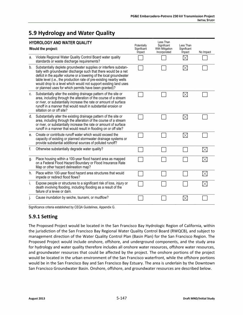
5.9 Hydrology and Water Quality
HYDROLOGY AND WATER QUALITY
Would the project: Potentially Significant
Impact
Less Than Significant
With Mitigation Incorporated
Less Than Significant
Impact No Impact
a. Violate Regional Water Quality Control Board water quality standards or waste discharge requirements?
b. Substantially deplete groundwater supplies or interfere substan-tially with groundwater discharge such that there would be a net deficit in the aquifer volume or a lowering of the local groundwater table level (i.e., the production rate of pre-existing nearby wells would drop to a level which would not support existing land uses or planned uses for which permits have been granted)?
c. Substantially alter the existing drainage pattern of the site or area, including through the alteration of the course of a stream or river, or substantially increase the rate or amount of surface runoff in a manner that would result in substantial erosion or siltation on or off site?
d. Substantially alter the existing drainage pattern of the site or area, including through the alteration of the course of a stream or river, or substantially increase the rate or amount of surface runoff in a manner that would result in flooding on or off site?
e. Create or contribute runoff water which would exceed the capacity of existing or planned stormwater drainage systems or provide substantial additional sources of polluted runoff?
f. Otherwise substantially degrade water quality?
g. Place housing within a 100-year flood hazard area as mapped on a Federal Flood Hazard Boundary or Flood Insurance Rate Map or other hazard delineation map?
h. Place within 100-year flood hazard area structures that would impede or redirect flood flows?
i. Expose people or structures to a significant risk of loss, injury or death involving flooding, including flooding as a result of the failure of a levee or dam.
j. Cause inundation by seiche, tsunami, or mudflow?
Significance criteria established by CEQA Guidelines, Appendix G.
5.9.1 Setting
The Proposed Project would be located in the San Francisco Bay Hydrologic Region of California, within the jurisdiction of the San Francisco Bay Regional Water Quality Control Board (RWQCB), and subject to management direction of the Water Quality Control Plan (Basin Plan) for the San Francisco Region. The Proposed Project would include onshore, offshore, and underground components, and the study area for hydrology and water quality therefore includes all onshore water resources, offshore water resources, and groundwater resources that could be affected by the project. The onshore portions of the project would be located in the urban environment of the San Francisco waterfront, while the offshore portions would be in the San Francisco Bay and San Francisco Bay Estuary. The area is underlain by the Downtown San Francisco Groundwater Basin. Onshore, offshore, and groundwater resources are described below.

PG&E Embarcadero-Potrero 230 kV Transmission Project INITIAL STUDY
Draft MND/Initial Study 5-148 August 2013
Surface Waters, Onshore
All surface water features in the urban environment of the project area have been channelized to facilitate development and flood control. San Francisco is subdivided into several historical watersheds, each of which drains to a common part of the San Francisco Bay during wet weather. Embarcadero Sub-station is located in the Mission Creek Watershed, and Potrero Switchyard is located in the Islais Creek Watershed.
Mission Creek is completely channelized, routed between Potrero Switchyard and Embarcadero Substa-tion, and draining eastward into China Basin. The Mission Creek Channel is a navigable tidal channel that is currently undergoing a restoration project to reestablish areas of wetland habitat and stabilize channel banks. Prior to channelization, Mission Creek received flows from artesian springs on Potrero Hill and tributaries originating on Twin Peaks, and emptied into Mission Bay, which existed as an estuary of combined salt and freshwater marshes, tidal mudflats, and shallow bay; as mentioned, the Mission Creek Channel now empties into China Basin. (p. 3.9-7 of PG&E, 2012
Islais Creek is also completely channelized, and the Islais Creek Channel is located approximately 2,500 feet south of the Potrero Switchyard. The Islais Creek Channel drains into the San Francisco Bay.
Surface Waters, Offshore
The San Francisco Bay Estuary is the largest estuary on the west coast of the United States, where fresh waters from California’s Central Valley mix with the saline waters of the Pacific Ocean (SFB RWQCB, 2011). San Francisco Bay is relatively shallow and subject to high rates of sediment movement. Approxi-mately 40 percent of the bay is less than six feet deep and about 70 percent is less than 16 feet deep. Offshore of Potrero Switchyard, San Francisco Bay is approximately 10 feet deep along the east-west portion of the proposed route. The bay waters trend from approximately 30 feet deep to about 70 feet deep along the south to north portion of the proposed transmission line route. At the northern terminus offshore from Embarcadero Substation, the bay is between 25 and 35 feet deep at the proposed north-ern landing through Berth 30 between Piers 28 and 30/32.
Water and Sediment Quality
As described above, the study area for hydrology and water quality includes both onshore and offshore waters, as well as groundwater resources. This section presents water and sediment quality data for both onshore and offshore surface water resources. Groundwater quality data is presented separately.
Table 5.9-1 provides an overview of surface waters in the project area that are currently listed as impaired on the Clean Water Act (CWA) Section 303(d) List for this region (the CWA is addressed in detail under “Applicable Regulations”).
As noted above, water quality impairments in Mission Creek and Islais Creek are associated with sewer overflow and industrial point sources. Water quality impairments in the San Francisco Bay Estuary are also largely associated with industrial sources. The following table describes surface water impairments in the project area.

PG&E Embarcadero-Potrero 230 kV Transmission Project INITIAL STUDY
August 2013 5-149 Draft MND/Initial Study
Table 5.9-1. Impaired Surface Waters in the Project Area
Water Body Type of Impairments Sources Area
Affected
Mission Creek Suspended in Water: Ammonia, Hydrogen Sulfide
In Sediments Only: Chlordane, Dieldrin, Lead, Mercury, PAH, PCB, Silver, Zinc
Combined Sewer Overflow; Industrial Point Sources
8.5 acres
Islais Creek Suspended in Water: Ammonia, Hydrogen Sulfide
In Sediments Only: Chlordane, Dieldrin, PAH, Sediment Toxicity
Combined Sewer Overflow; Industrial Point Sources
46 acres
San Francisco Bay, Central
Chlordane, DDT, Dieldrin, Dioxin Compounds (including 2, 3, 7, 8-TCCD), Exotic Species, Furan Compounds, Mercury, PCB, dioxin-like PCB, Selenium
Agriculture; Nonpoint Sources; Atmospheric Deposition; Ballast Water; Industrial and Municipal Point Sources; Natural Sources; Resource Extraction
70,992 acres
Notes: PAH = Polycyclic Aromatic Hydrocarbons; PCB = Polychlorinated biphenyls. The CWA Section 303(d) list does not differentiate sediment versus water contamination for the Central San Francisco Bay; water quality in the San Francisco Bay is also addressed in Table 5.9-2. Source: SWRCB, 2006
As a condition of their discharge permit, most dischargers to the San Francisco Bay are required to par-ticipate in the Regional Monitoring Program (RMP), a data collection, research, and coordination effort administered by the San Francisco Estuary Institute (SFEI) (p. 3.9-8 of PG&E, 2012). Data collected for the RMP indicate that water quality impairments, concerns, and priorities in the San Francisco Bay Estuary include high concentrations of PCBs, as well as exceedances of water quality objectives in Central Bay waters, as indicated in Table 5.9-1. RMP data also indicate that water quality in the Central Bay, tends to be better than water quality in the North and South Bay areas (p. 3.9-8 of PG&E, 2012). Water quality data from the RMP Annual Monitoring Results for the Central Bay Region is presented in Table 5.9-2.
Table 5.9-2. Water Quality, San Francisco Bay, 2005-2010
Constituent
Concentration (μg/L)
Maximum Measured
Median Measured
Water Quality Objectives
4-Day Average 1-Hour Average 24-Hour Average
Arsenic 2.5 2.05 36 69 n/a
Cadmium 0.113 0.1 9.3 42 n/a
Copper 3.17 1.66 3.12 4.8a n/a
Lead 0.60 0.34 8.1 210 n/a
Mercury 0.009 0.005 0.025 2.1 n/a
Nickel 4.12 2.34 8.2 74 n/a
Selenium 0.176 0.156 5b 20.3 n/a
Silver 0.014 0.006 n/a 1.9 n/a
Zinc 4.19 2.24 81 90 n/a
PAH 0.042 0.028 n/a n/a 15
PCB (Sum of 268) 0.000295 0.000222 n/a n/a n/a
Notes: PAH = Polycyclic Aromatic Hydrocarbons; PCB = Polychlorinated biphenyls. a - Water quality objectives for copper were promulgated by the California Toxics Rule (CTR) and may be updated by USEPA without amending
the Basin Plan. Note: at the time of writing of the Basin Plan, the values were 3.1 μg/L (4-day average) and 4.8 μg/L (1-hr. average). b - Selenium criteria were promulgated for all San Francisco Bay/Delta waters in the National Toxics Rule (NTR). The NTR criteria specifically
apply to San Francisco Bay upstream to and including Suisun Bay and Sacramento–San Joaquin Delta. Note: at the time of writing of the Basin Plan, the values were 5.0 μg/L (4-day average) and 20 μg/L (1-hr. average).
Source: p. 3.9-9 of PG&E, 2012.

PG&E Embarcadero-Potrero 230 kV Transmission Project INITIAL STUDY
Draft MND/Initial Study 5-150 August 2013
The table above shows that measured concentrations of water quality constituents in the San Francisco Bay Estuary are within the identified Water Quality Objectives, with the exception of copper, which had a measured maximum concentration of 0.05 μg/L above the 4-day Average Objective.
The RMP Annual Monitoring Results for the Central Bay Region also reflect sediment impairments in the San Francisco Bay Estuary. Sediment quality data from the RMP Annual Monitoring Results for the Central Bay Region is presented below, in Table 5.9-3. This table shows measured concentrations of con-taminants in bay sediments, in comparison to the National Oceanic and Atmospheric Administration (NOAA) sediment benchmarks termed Effects Range-Low (ERL) and Effects Range-Median (ERM).
Table 5.9-3. Sediment Quality, San Francisco Bay, 2005-2010
Constituent
Concentration (μg/L)
Maximum Measured
Median Measured
Screening Concentrations
ERL ERM
Metals (mg/kg dw)
Arsenic 18.30 9.94 8.2 70
Cadmium 0.34 0.21 1.2 9.6
Copper 43.89 36.35 34 270
Lead 33.20 20.09 46.7 218
Mercury 0.94 0.25 0.15 0.71
Nickel 86.9 73.8 20.9 51.6
Selenium 0.46 0.19 n/a n/a
Silver 0.378 0.194 1.00 3.70
Zinc 129 97 150 410
PAH (Sum of 25) 43,047 (CB044S) 3,086 4.022 44,792
PBDE 9.3 2.08 n/a n/a
PCB (Sum of 268) 21.8 9.5 22.7 180.0
DDTs (μg/kg dw) 13.3 2.8 1.58 46.1
Chlordanes (μg/kg dw) 0.35 0.14 0.5 6.0
Dieldrin (μg/kg dw) 0.19 0.08 0.02 8.00
Dioxins / Furans1 0.38 0.29 n/a n/a Notes: 1 - All data are from 2005-2010 except dioxin/furans data, which are from 2008-2010. PAH = Polycyclic Aromatic Hydrocarbons; PBDE = Polybrominated Diphenyl Ethers; PCB = Polychlorinated biphenyls (μg/kg dw). ERL = Effects Range-Low are levels that are indicative of concentrations below which adverse effects rarely occur. ERM = Effects Range-Median are levels above which adverse effects frequently occur. Units: mg/kg dw = milligrams per kilogram in dry weight; μg/kg dw = micrograms per kilogram in dry weight. Source: p.3.9-10 of PG&E, 2012.
Sediment concentrations greater than the ERM are generally interpreted as an indication of contami-nation. The table above indicates that sediments in the Proposed Project area are affected by relatively high levels of mercury, nickel, and PAHs, as well as marginally high levels of arsenic, copper, and PCBs.
Flood Hazards
A 100-year floodplain is an area anticipated to be inundated by flows associated with the storm event of magnitude likely to occur once every one hundred years, or the storm with a one percent chance of occurring each year. The Federal Emergency Management Agency (FEMA) defines 100-year floodplains, also referred to as Special Flood Hazard Areas, on Flood Insurance Rate Maps (FIRMs) produced under the National Flood Insurance Program (NFIP), which the City of San Francisco participates in. FEMA issued a preliminary FIRM for the City of San Francisco in 2007, but this FIRM has yet to be finalized

PG&E Embarcadero-Potrero 230 kV Transmission Project INITIAL STUDY
August 2013 5-151 Draft MND/Initial Study
(SFGov, 2011). In the meantime, the City Administrator’s Office has created an Interim Floodplain Map in order to assess existing floodplain hazards in the area (SFGov, 2011). The Interim Floodplain Map is based on FEMA’s preliminary FIRM, and shows that portions of the Proposed Project are located within a Special Flood Hazard Area (SFGov, 2008). Specifically, portions of the project’s HDD segments cross through a Special Flood Hazard Area.
Flood hazards may also occur through the failure of a dam or levee, most likely associated with a strong seismic event. The San Francisco Water Department owns above-ground reservoirs and tanks within San Francisco and has delineated inundation areas. The project area is not located within one of these areas. (p. 3.9-9 of PG&E, 2012)
The potential for a tsunami event to occur also introduces flooding hazard. Portions of the proposed facilities, including the Potrero Switchyard, are located within a Tsunami Hazard Area identified by the California Emergency Management Agency (CEMA) (CEMA, 2013). Tsunamis are large waves in the ocean or other large water bodies generated by earthquakes, coastal or submarine landslides, or volca-noes. Tsunamis of the magnitude with potential to result in damage are not common on the California coast. The most devastating tsunami to affect California in recent history was from the magnitude 9.2 Alaskan earthquake of 1964 located in the Cascadia subduction zone. Areas of Northern California expe-rienced a 6-meter (20-foot) tsunami wave that flooded low-lying communities, such as Crescent City, but the tsunami wave height only reached 1.1 meters (just over 3 feet) near San Francisco. A tsunami caused by a very large earthquake elsewhere on the Pacific Rim could also reach the California coast many hours after the earthquake. For example, the tsunami caused by the 2011 magnitude 9.0 Tohoku earthquake near Japan caused a sea level fluctuation at San Francisco’s Marina District of 0.62 meters (about 2 feet; PG&E, 2013).
Most of the faults that can generate large tsunamis would result from earthquakes located several hundreds of miles away, and the ground motions generated from those sources would be generally very low to non-detectible in the project area. Crustal faults in the Bay Area, such as the San Andreas Fault, are unlikely to generate a significant tsunami. A repeat of the 1906 earthquake is expected to generate less than 10 cm (4 inches) of sea level disturbance (tsunami) based on an actual reading from the 1906 earthquake. Sea level disturbance inside of the Golden Gate Bridge is expected to be less than the 10 cm recorded at the Presidio. (PG&E, 2013)
Groundwater Resources
The project area is underlain by the Downtown San Francisco Groundwater Basin, which encompasses approximately 7,600 acres (12 square miles) of the northeast portion of the San Francisco peninsula. Recharge to this basin occurs from infiltration of rainfall, landscape irrigation, and leakage of water and sewer pipes, with approximately half of all recharge associated with leakage from municipal water and sewer pipes. A groundwater budget is not available for this basin, but little to no seasonal fluctuations in groundwater level trends suggest a stable budget. (DWR, 2004)
Due to this groundwater basin’s location on the coast, and low ground elevations in the area, depth to groundwater is relatively shallow. Groundwater is estimated to occur between five and 20 feet below ground surface throughout the project area, and groundwater levels are likely tidally influenced (p. 3.9-9 of PG&E, 2012). Potential use of groundwater in this basin is limited to non-potable uses due to historic industrial development, high salinity, and density of contaminated sites (p. 3.9-9 of PG&E, 2012).
As discussed in Section 3.8 (Hazards and Hazardous Materials), potential contamination in soil and ground-water has been documented at several locations along the Proposed Project route (p. 3.9-9 of PG&E,

PG&E Embarcadero-Potrero 230 kV Transmission Project INITIAL STUDY
Draft MND/Initial Study 5-152 August 2013
2012). Groundwater quality throughout the basin is affected by high concentrations of nitrates and elevated chloride, boron, and total dissolved solids (TDS). The high nitrate levels are attributable to recharge from sewer pipe leakage, and irrigation return flows, while elevated chloride and TDS levels are likely due to sewer pipe leakage, as well as historic and current seawater intrusion, and connate water, or water trapped in rock strata at the time for formation (DWR, 2004).
Applicable Regulations
Federal
Clean Water Act
The Federal Water Pollution Control Act was passed in 1972, and was amended in 1977 as the Clean Water Act (CWA, 33 U.S.C. 1251 1376). The CWA was reauthorized in 1981, 1987, and 2000, and estab-lishes the basic structure for regulating discharges of pollutants into the waters of the United States and has given the U.S. Environmental Protection Agency (EPA) the authority to implement pollution control programs. The CWA requires states to set standards to protect, maintain, and restore water quality through the regulation of point source and certain non-point source discharges to surface waters. Many pollutants are regulated under the CWA, including various toxic pollutants, total suspended solids, bio-logical oxygen demand and pH (acidity/alkalinity measure scale). Those discharges are regulated by the National Pollutant Discharge Elimination System (NPDES) permit process, described below under the “Section 402” discussion. The CWA generally applies to surface Waters of the United States, managed by the U.S. Army Corps of Engineers (USACE).
Section 401
Section (§) 401 of the CWA requires the State (via the nine RWQCBs) to issue Water Quality Certifica-tions (WQC) for licenses or permits issued for, among other things, the discharge of dredged or fill mate-rials to federally jurisdictional waters, or Waters of the United States, which are located within the State. In order for a §401 WQC to be required, the activity causing the discharge must be authorized by a permit or license issued by a federal agency; federal licenses and permits most frequently subject to §401 include CWA §402 (NPDES) permits issued by EPA, CWA §404 (dredge and fill) permits issued by the USACE, hydropower licenses issued by the Federal Energy Regulatory Commission (FERC), and Rivers and Harbors Act (RHA) §9 and §10 permits issued by the USACE (USEPA OWOW, 2010).
Dredging permit applicants intending to dispose of material in water must obtain a §401 WQC from the State of California through the applicable regional water board, in this case the San Francisco Bay RWQCB. After reviewing the project, the RWQCB may recommend to the SWRCB that certification be granted or denied. Dredged material considered for disposal in water must be tested to determine its suitability for disposal. Section 401 of the CWA provides authority to determine suitability of dredged material for water disposal to the State, via the RWWCBs. (PG&E, 2012)
Section 402
Section 402 of the CWA prohibits the discharge of pollutants from point sources to Waters of the United States, unless authorized under an NPDES permit issued by the United States Environmental Protection Agency (USEPA); one exception to this is the discharge of dredged or fill material, which is regulated under §404 of the CWA. In California, NPDES permitting authority is delegated by the USEPA to the State Water Resources Control Board (SWRCB) and administered by the nine RWQCBs. As mentioned above, the Proposed Project would be within the jurisdiction of the San Francisco Bay RWQCB (Region 2); any

PG&E Embarcadero-Potrero 230 kV Transmission Project INITIAL STUDY
August 2013 5-153 Draft MND/Initial Study
point-source discharges associated with the project would need to be permitted by the San Francisco Bay RWQCB.
Projects that disturb one or more acres and would result in discharge(s) to Waters of the U.S. are required to obtain NPDES coverage under the Construction General Permits. Coverage under the NPDES Construction General Permit (Order No. 2009-0009-DWQ; NPDES Permit No. CAS000002) may be obtained if the following requirements are met:
Develop and implement a Storm Water Pollution Prevention Plan (SWPPP) which specifies BMPs that will prevent all construction pollutants from contacting stormwater and with the intent of keeping all products of erosion from moving offsite into receiving waters;
Eliminate or reduce non-stormwater discharges to storm sewer systems and other waters of the nation; and
Perform inspections of all BMPs.
NPDES coverage under the Construction General Permit also regulates non-stormwater discharges, such as those associated with dewatering of trenches or other excavations that would occur under the Pro-posed Project.
Section 404
Section 404 of the CWA establishes a permit program administered by the USACE, which regulates the discharge of dredged or fill material into federally jurisdictional waters, or Waters of the U.S. (including wetlands). The USACE is mandated to protect and maintain navigable capacity of the nation’s waters under Section 33 of the Code of Federal Regulations (CFR), Navigation and Navigable Waters. Guidelines for implementation of this portion of the CWA are referred to as the §404(b)(1) Guidelines and were developed by the USEPA in conjunction with USACE (40 CFR Parts 230). The Guidelines allow the discharge of dredged or fill material into jurisdictional waters only if there is no practicable alternative that would have less adverse impacts.
Dredged material must be tested for quality prior to aquatic disposal, in order to determine its potential effects on the disposal site environment. Testing is also used to determine whether dredged material is suitable for unconfined aquatic disposal. Section 404 of the CWA defines testing requirements for compatibility of dredged material with disposal sites located in or potentially affecting inland waters, such as the San Francisco Bay. In addition, a §401 WQC is required for any §404 permit actions.
Section 303(d)
Section 303(d) of the CWA (CWA, 33 USC 1250, et seq., at 1313(d)) requires states to identify “impaired” waterbodies as those which do not meet water quality standards. States are required to compile this information in a list and submit the list to the USEPA for review and approval. This list is known as the §303(d) list of impaired waters. Table 5.9-1 provides an overview of surface waters in the project area that are currently listed as impaired on the 303(d) list for this region, including the San Francisco Bay. As required per §303(d) of the CWA, the State and Regional Water Quality Control Boards assess water quality data for California’s waters every two years to determine if they contain pollutants at levels that exceed protective water quality criteria and standards. The most recent update of the 303(d) list occurred in 2010 and the revised list was approved by the USEPA in December 2011 (SWRCB, 2011); this updated list did not change impairments in the Proposed Project area.
As part of the 303(d) listing process, states are required to prioritize waters and watersheds for future development of Total Maximum Daily Load (TMDL) requirements. The SWRCB and RWQCBs have

PG&E Embarcadero-Potrero 230 kV Transmission Project INITIAL STUDY
Draft MND/Initial Study 5-154 August 2013
ongoing efforts to monitor and assess water quality, to prepare the §303(d) list, and to develop TMDL requirements. Within the San Francisco Bay Region, the current list identifies more than 270 impair-ments in 88 water bodies; RWQCB staff is currently developing programs to address more than 160 of these TMDL listings (SFB RWQCB, 2013). TMDL programs in the project area include efforts to address multiple constituents in the San Francisco Bay, including copper, mercury, nickel, and PCBs, as well as Diazinon (pesticides) in San Francisco Bay Area urban creeks (SFB RWQCB, 2013).
Dredged Materials Management Office
The Dredged Materials Management Office (DMMO) facilitates the processing of dredging permit appli-cations within existing laws, regulations, and policies. The DMMO was created as part of the LTMS Pro-gram for processing applications for dredging and disposal projects in the San Francisco Bay region (the LTMS Program is described below, under “Local”). The DMMO is an interagency group that includes USEPA, USACE, California State Lands Commission (CSLC), BCDC, and California Department of Fish and Wildlife (CDFW). Participating agencies also include the National Marine Fisheries Service (NMFS) and the U.S. Fish and Wildlife Service (USFWS), who provide advice and expertise to the process. This interagency group cooperatively reviews sediment quality sampling plans, analyzes the results of sedi-ment quality sampling, makes suitability determinations for disposal, and offers a consolidated applica-tion that can be jointly processed before each agency issues their respective permits for dredging and disposal projects in the San Francisco Bay. The DMMO was specifically designed to provide a mechanism for consistent review of permit applications through coordinated efforts among the member agencies; no new regulatory statutes were initiated in the formation of the DMMO, and all applicable regulatory authority and processes of the member agencies remain in full force and effect.
Rivers and Harbors Act of 1899
The Rivers and Harbors Act of 1899 regulates development and use of the nation’s navigable waterways, such as the San Francisco Bay. Navigable waters are defined as those subject to the ebb and flow of the tide and susceptible to use in their natural condition or by reasonable improvements as means to trans-port interstate or foreign commerce. Section 10 of the Rivers and Harbors Act prohibits the unauthor-ized obstruction or alteration of navigable waters, and vests regulatory authority in the USACE for work in, under, or over any navigable water of the U.S. (federally jurisdictional waters, or Waters of the U.S.). The Rivers and Harbors Act applies to any dredging or disposal of dredged materials, as well as excavation, filling, re-channelization, or any other modification of navigable water. Most activities covered under this act are also covered under §404 of the CWA.
Oil Pollution Act of 1990
The Oil Pollution Control Act (OPA) of 1990 is the principal statute governing oil spills into the nation’s waterways. OPA was passed in the wake of the Exxon Valdez oil spill in March of 1989. The statute establishes liability and limitations on liability for damages resulting from oil pollution, and establishes a fund for the payment of compensation for such damages. In conjunction with the Comprehensive Envi-ronmental Response, Compensation, and Liability Act of 1980 (CERCLA), commonly known as Superfund, OPA mandates a National Oil and Hazardous Substances Pollution Contingency Plan (NCP) to provide the organizational structure and procedures for preparing for and responding to discharges of oil and releases of hazardous substances, pollutants, and contaminants. OPA requires preparation of spill pre-vention and response plans by coastal facilities, vessels, and certain geographic regions. OPA amended the CWA and includes the Oil Terminal and Oil Tanker Environmental Oversight and Monitoring Act of 1990. OPA further requires increased United States Coast Guard (USCG) involvement with vessel traffic service systems, vessel and facility monitoring, and oil spill prevention and cleanup.
PG&E Embarcadero-Potrero 230 kV Transmission Project INITIAL STUDY
August 2013 5-155 Draft MND/Initial Study
The Ports and Waterways Safety Act of 1972
The Ports and Waterways Safety Act, as amended by the Port and Tanker Safety Act of 1978, provides the strongest authority for the USCG’s program to increase vessel safety and protect the marine envi-ronment in ports, harbors, waterfront areas, and navigable waters. The Ports and Waterways Safety Act authorizes Vessel Traffic Services, controls vessel movement, and establishes requirements for vessel operation and other related port safety controls. A number of other laws also call for USCG enforce-ment, including the Federal Water Pollution Control Act, which delegates enforcement authority and responsibility to the USCG in cases where oil and hazardous substances are discharged into U.S. waters in harmful quantities. In addition, the Act to Prevent Pollution from Ships limits the operational dis-charges of oil from ships and requires reception facilities to receive waste that cannot be discharged at sea, and the Marine Protection, Research and Sanctuaries Act of 1972 requires USCG surveillance of ocean dumping activities.
National Flood Insurance Program
The National Flood Insurance Program (NFIP) is administered by the Federal Emergency Management Agency (FEMA), a component of the U.S. Department of Homeland Security. The NFIP is a federal pro-gram enabling property owners in participating communities to purchase insurance protection against losses from flooding. In support of the NFIP, FEMA identifies flood hazard areas throughout the U.S. and its territories by producing Flood Insurance Rate Maps (FIRMs). FIRMs identify the estimated limits of the 100-year floodplain for mapped water courses, among other flood hazards. A 100-year floodplain is defined as any land that would be inundated by the magnitude of flood that has a one percent chance of occurring in any given year (also referred to as the “base flood”). Participation in the NFIP is based on an agreement between communities and the federal government. The agreement states that if a commu-nity adopts and enforces a floodplain management ordinance to reduce future flood risks to new con-struction in Special Flood Hazard Areas, the federal government will make flood insurance available to the community. Portions of the project area are located within FEMA-designated Flood Hazard Areas.
State
Porter-Cologne Water Quality Control Act
The Porter-Cologne Water Quality Control Act of 1967 (California Water Code §13000 et seq.) regulates surface water and groundwater within California and assigns responsibility for implementing CWA §401 through §402 and §303(d), discussed above, to the SWRCB and the nine RWQCBs. Porter-Cologne also established the SWRCB and divided the state into nine regions, each of which is overseen by a RWQCB, and requires that water quality criteria to protect State waters are developed for each of the nine regions and adopted in each region’s Water Quality Control Plan, also referred to as the Basin Plan. In compliance with Porter-Cologne, each Basin Plan identifies beneficial uses for waters of the State within the Region, as well as narrative and numerical water quality standards, and procedures for implement-ing such standards.
For any project that would discharge waste (including fill) to waters of the State, the project applicant must file a report of waste discharge with the applicable RWQCB; this report serves as an application to the RWQCB for issuance of waste discharge requirements (WDRs) for the project, where WDRs function as a permit to control water quality degradation. The RWQCB may also issue a waiver of WDRs. No discharges to waters of the State may occur until the RWQCB has issued WDRs or a waiver of WDRs. As a water quality control permit, WDRs must implement Basin Plan requirements for water quality stand-ards, taking into account the beneficial use(s) associated with affected water(s). (CERES, 2002)

PG&E Embarcadero-Potrero 230 kV Transmission Project INITIAL STUDY
Draft MND/Initial Study 5-156 August 2013
WDRs are distinct from the Water Quality Certifications because they apply to waters of the State and are authorized per the California Porter-Cologne Water Quality Control Act, whereas Water Quality Certifications apply to Waters of the U.S. and are authorized per §401 of the federal CWA. The RWQCBs are responsible for issuing both types of permits. Where both federal and state waters would be affected, a §401 Water Quality Certification may be implemented to satisfy both federal and state laws. Where no federally jurisdictional waters (Waters of the U.S.) would be affected, a WDR per the Porter-Cologne Act may still be required to protect waters of the State.
The Proposed Project would be located within the San Francisco Bay Region and subject to the Basin Plan administered by the San Francisco Bay RWQCB. The San Francisco Bay Region is 4,603 square miles, predominately characterized by 1,100 square miles of the 1,600-square-mile San Francisco Bay Estuary, where fresh waters from California’s Central Valley mix with the saline waters of the Pacific Ocean (SFB RWQCB, 2011). The Basin Plan for the San Francisco Bay Region was originally adopted in 1975, and has been revised numerous times since then; the current edition of the Basin Plan was adopted in 2011 (SFB RWQCB, 2011). In accordance with the Porter-Cologne Water Quality Control Act, the Basin Plan sets forth implementation policies, goals, and water management practices for the Region, and discharges to the surface waters in the region are subject to the regulatory standards set forth in the Basin Plan.
McAteer-Petris Act
The McAteer-Petris Act (Act) established the San Francisco Bay Conservation and Development Commis-sion (BCDC) to manage planning and regulation of San Francisco Bay, emphasizing the elimination of unnecessary fill placement, the use of the bay for water-oriented uses, and the inclusion of public access in bay planning. The BCDC’s jurisdiction includes all areas of the bay that are subject to tidal action, including sloughs and marshlands, as well as a 100-foot shoreline band surrounding the bay, saltponds and managed wetlands defined in the Act, and certain additional designated waterways. In accordance with the Act, permits must be obtained from the BCDC for the placement of fill, extraction of materials, and substantial changes in the use of land, water, or existing structures in the bay. In determining whether to issue permits, the BCDC considers policies identified in the Act and in the San Francisco Bay Plan. These policies generally authorize fill or excavation of wetlands only for water-dependent projects where no feasible upland alternatives exist, and only if wetlands impacts are mitigated. (CERES, 2012) The proposed submarine cable would be located within BCDC jurisdictional areas and would require an administrative permit by BCDC. Additionally, the USACE and RWQCB permit would be subject to a con-sistency determination from BCDC for dredging and disposal activity in San Francisco Bay.
Burton Act of 1968
In accordance with the Burton Act of 1968, the State of California transferred all responsibilities for the San Francisco waterfront to the City and County of San Francisco, and the Port Commission was created to manage the waterfront. The Port of San Francisco receives no financial support from the City and relies almost solely on the leasing of Port property for its revenues (SF Port, 2013). The Port Commission has jurisdiction over the Potrero Switchyard area, as well as the submarine cables and portions of the HDD, and the project requires a license by the San Francisco Port Commission.
Local
The CPUC has exclusive jurisdiction over siting, design, and construction of the Proposed Project, and the project is therefore not subject to local discretionary regulations. However, following is a summary of local regulations and regulatory agencies relating to hydrology and water quality, provided for infor-mational purposes and to assist with the CEQA review.

PG&E Embarcadero-Potrero 230 kV Transmission Project INITIAL STUDY
August 2013 5-157 Draft MND/Initial Study
San Francisco Public Works Code, Article 21
Article 21 of the San Francisco public Works Code restricts the use of potable water for soil compaction and dust control activities. Relevant sections are identified and summarized below.
Section 1101, Restriction of Use of Potable Water, prohibits the use of potable water for soil com-paction or dust control activities within the City and County of San Francisco, unless permission is obtained from the City Water Department.
Section 1103, Use of Non-potable Water, stipulates that reclaimed water, well water, and ground-water must be transported and used in accordance with State Health Department, State Water Resources Control Board, Regional Water Quality Control Board, and City Departments of Health and Public Works orders, standards, and regulations.
Section 1104, Inspections and Stop Orders, authorizes the Department of Public Works to inspect all construction and demolition sites in the City of San Francisco to determine compliance with this Article, and to stop the construction or demolition work when in violation of this Article.
San Francisco Bay Plan
The San Francisco Bay Plan (Plan) was first adopted by the BCDC in 1968, and has been amended period-ically. The latest amendment was in 2010. The Plan is administered by the BCDC, which is authorized per the Plan to control both filling and dredging activities in the bay, as well as bay-related shoreline devel-opment (SFBCDC, 2010). According to the Plan, the BCDC can authorize dredging when it can be dem-onstrated that the dredging is needed to serve a water-oriented use or other important public purpose, the materials to be dredged meet the water quality requirements of the RWQCB, important fisheries and natural resources would be protected, dredging is minimized through project siting and design, and the materials would, if feasible, be reused or disposed outside the bay and certain waterways (p. 3.9-4 of PG&E, 2012).
Policies identified in the Plan that are applicable to the Proposed Project are listed below, as identified in the “Water Quality” section of the Plan.
1) Bay water pollution should be prevented to the greatest extent feasible. The Bay's tidal marshes, tidal flats, and water surface area and volume should be conserved and, whenever pos-sible, restored and increased to protect and improve water quality. Fresh water inflow into the Bay should be maintained at a level adequate to protect Bay resources and beneficial uses.
2) Water quality in all parts of the Bay should be maintained at a level that will support and promote the beneficial uses of the Bay as identified in the San Francisco Bay Regional Water Quality Control Board's Water Quality Control Plan, San Francisco Bay Basin, and should be protected from all harmful or potentially harmful pollutants.
3) New projects should be sited, designed, constructed and maintained to prevent or, if preven-tion is infeasible, to minimize the discharge of pollutants into the Bay by: (a) controlling pol-lutant sources at the project site; (b) using construction materials that contain nonpolluting materials; and (c) applying appropriate, accepted and effective best management practices, especially where water dispersion is poor and near shellfish beds and other significant biotic resources.
4) When approving a project in an area polluted with toxic or hazardous substances, the Com-mission should coordinate with appropriate local, state, and federal agencies to ensure that the project will not cause harm to the public, to Bay resources, or to the beneficial uses.

PG&E Embarcadero-Potrero 230 kV Transmission Project INITIAL STUDY
Draft MND/Initial Study 5-158 August 2013
San Francisco Waterfront Special Area Plan
The City and County of San Francisco, along with the Port and the BCDC, have adopted the San Francisco Waterfront Special Area Plan. The Special Area Plan divides the waterfront area into three geographic areas — Fisherman’s Wharf, Northeastern Waterfront, and Southern Waterfront. The Special Area Plan also identifies both geographic-specific policies, applicable to the aforementioned areas, and general policies. The Proposed Project is located within the Northeastern Waterfront and Southern Waterfront areas. Both of these areas apply policies of the San Francisco Bay Plan, in greater specificity, as their geographic-specific policies. In the Northeastern Waterfront area, additional geographic-specific policies are identified to address using fill for public trust uses, and to guide the provision of public benefits and public access. (SFBCDC, 2010).
Long Term Management Strategy for the Placement of Dredged Material in the San Francisco Bay Region (LTMS) Program
The LTMS Program was established in 1990 due to concerns regarding mounding of dredged material at the main disposal site near Alcatraz Island, and potential impacts from dredging and dredged material disposal to water quality, wildlife, and uses of the bay. The LTMS Program was established collectively by the BCDC, the San Francisco Bay RWQCB, the San Francisco District of the USACE, and the U.S. Envi-ronmental Protection Agency (EPA). In 2000, the LTMS agencies adopted the LTMS plan to reduce in-Bay disposal of dredged material and to maximize the beneficial reuse of dredged material. Beneficial reuse may include the following: construction of wetland restoration projects in areas that have been histor-ically diked off from the bay and subsided; repair levees and flood control features in areas such as the Delta; and use as construction fill where appropriate. (SFBCDC, 2007)
Applicant Proposed Measures
PG&E proposes to implement measures during the design, construction, and operation of the Proposed Project to ensure it would occur with minimal environmental impacts in a manner consistent with applic-able rules and regulations. Applicant Proposed Measures (APMs) are considered part of the Proposed Project in the evaluation of environmental impacts. CPUC approval would be based upon PG&E adhering to the Proposed Project as described in this document, including this project description and the APMs, as well as any adopted mitigation measures identified by this Initial Study.

PG&E Embarcadero-Potrero 230 kV Transmission Project INITIAL STUDY
August 2013 5-159 Draft MND/Initial Study
Table 5.9-4. Applicant Proposed Measures (APMs) Related to Hydrology and Water Quality
APM Number Issue Area
Hydrology and Water Quality
APM WQ‐1 Development and Implementation of a Stormwater Pollution Prevention Plan (SWPPP). Stormwater discharges associated with project construction activities are regulated under the General Construction Permit. Cases in which construction will disturb more than one acre of soil require submittal of a Notice of Intent, development of a SWPPP (both certified by the Legally Responsible Person (LRP)), periodic monitoring and inspections, retention of monitoring records, reporting of incidences of noncompliance, and submittal of annual compliance reports. PG&E will comply with all General Construction Permit requirements.
Following project approval, PG&E will prepare and implement a SWPPP, which will address erosion and sediment control to minimize construction impacts on surface water quality. The SWPPP will be designed specifically for the hydrologic setting of the Proposed Project in proximity to the San Francisco Bay. Implementation of the SWPPP will help stabilize graded areas and reduce erosion and sedimentation. The SWPPP will designate BMPs that will be adhered to during construction activities. Erosion and sediment control BMPs, such as straw wattles, erosion control blankets, and/or silt fences, will be installed in compliance with the SWPPP and the General Construction Permit. Suitable soil stabilization BMPs will be used to protect exposed areas during construction activities, as specified in the SWPPP. During construction activities, BMPs will be in place to address construction materials and wastes.
BMPs, where applicable, will be designed by using specific criteria from recognized BMP design guidance manuals. Erosion and sediment‐minimizing efforts will include measures such as the following:
Defining ingress and egress within the project site to control track‐out
Implementing a dust control program during construction
Properly containing stockpiled soil
Identified erosion and sediment control measures will be installed in an area before construction begins and inspected and improved as needed before any anticipated storm events. Temporary sediment control measures intended to minimize sediment transport from temporarily disturbed areas, such as silt fences or wattles, will remain in place until disturbed areas are stabilized. In areas where soil is to be temporarily stockpiled, soil will be placed in a controlled area and managed with similar erosion‐control techniques. Where construction activities occur near a surface water body or drainage channel, the staging of construction materials and equipment and excavation spoil stockpiles will be placed at least 50 feet from the water body and properly contained, such as with berms and/or covers, to minimize risk of sediment transport to the drainage. Any surplus soil will be transported from the site and appropriately disposed of.
A copy of the SWPPP will be provided to the CPUC for recordkeeping. The plan will be maintained and updated during construction as required by the SWRCB.
APM WQ‐2 Implementation of a Worker Environmental Awareness Program. The project’s worker environmental awareness program will communicate environmental issues and appropriate work practices specific to this project to all field personnel. These will include spill prevention and response measures and proper BMP implementation. The training program will emphasize site‐specific physical conditions to improve hazard prevention (such as identification of flow paths to nearest water bodies) and will include a review of all site‐specific water quality requirements, applicable portions of erosion control and sediment transport BMPs contained in the SWPPP (APM WQ‐1) and the health and safety plan (see APM HM‐2 in PEA Section 3.8.4.2). A copy of the project’s worker environmental awareness training record will be provided to the CPUC for recordkeeping. An environmental monitoring program will also be implemented to ensure that the plans are followed throughout the construction period.
APM WQ‐3 Implementation of Hazardous Material and Emergency Response Procedures. PG&E will implement construction controls, training and communication to minimize the potential exposure of the public and site workers to potential hazardous materials during all phases of project construction.
These construction practices include construction worker training appropriate to the site worker’s role (see APM HM‐3), containment and spill control practices in accordance with the SWPPP (see APM WQ‐1), and emergency response to ensure appropriate cleanup of accidental spills. If it is necessary to store chemicals, they will be managed in accordance with all applicable regulations. Material safety data sheets will be maintained and kept available on site, as applicable. The project SWPPP (APM WQ‐1) will identify areas where refueling and vehicle‐maintenance activities and storage of hazardous materials, if any, will be permitted.
(Also see APM HM‐1.)

PG&E Embarcadero-Potrero 230 kV Transmission Project INITIAL STUDY
Draft MND/Initial Study 5-160 August 2013
Table 5.9-4. Applicant Proposed Measures (APMs) Related to Hydrology and Water Quality
APM WQ‐4 Emergency Spill Supplies and Equipment. Materials will be available on the project site during construction to contain, collect and dispose of any minor spill (for example, absorbent material, tarps, and storage drums). In the event that excess water or liquid concrete escapes during pouring activities, it will be directed to lined and bermed areas adjacent to the borings, where the water will evaporate and the concrete will begin to set. Once the excess concrete has been allowed to set up, it will be removed and transported for disposal, according to applicable regulations.
(Also see APM HM‐4.)
APM WQ‐5 Soil Sampling/Wastewater and Groundwater Characterization. Soil sampling and potholing will be conducted in onshore project areas before construction begins, and soil information will be provided to construction crews to inform them about soil conditions and potential hazards. If hazardous substances are unexpectedly encountered during trenching, work will be stopped until the material is properly characterized and appropriate measures are taken to protect human health and the environment. If excavation of hazardous materials is required, they will be handled in accordance with applicable regulations.
Prior to initiating excavation activities along the underground transmission cable routes, soil borings will be advanced to identify areas where contaminated groundwater may be contacted. The location, distribution, and/or frequency of the borings will give adequate representation of the condit ions in the construction area. If suspected contaminated groundwater is encountered at the depths of the proposed construction, samples will be collected and submitted for laboratory analysis of petroleum hydrocarbons, metals, volatile organic compounds, and semi‐volatile organic compounds. If necessary, groundwater will be collected during construction, contained, and disposed of in accordance with all applicable regulations. Appropriate personal protective equipment will be used and waste management will be performed in accordance with applicable regulations. Non‐contaminated groundwater will be released to one of the city ’s combined sanitary and stormwater drainage systems (with prior approval) or contained, tested, and disposed of in accordance with applicable regulations.
(Also see APM HM‐5.)
APM WQ‐6 Horizontal Directional Drilling (HDD) Monitoring and Management. HDD operations will include best management practices for monitoring for loss of drilling fluids, spill containment and response measures. Monitoring and response measures specific to the site subsurface conditions and construction equipment will be included in a Frac‐out Plan. The objectives of this monitoring program are to quickly identify any unplanned release of drilling fluids during drilling; determine the size, extent, and location of the release; and evaluate and implement appropriate containment and cleanup measures after a release has occurred. Routine monitoring will be conducted at regular intervals during all drilling activities. More intensive monitoring will be implemented if drilling fluid circulation to the HDD endpoints is lost or an unplanned release is detected.
In general, both the drilling technique and early detection and response shall be used to minimize release of fluids to the environment. Techniques to minimize potential loss of drilling fluids include termination of the pilot hole short of the exit into the bay, monitoring of fluid pressures, and adjustments to the drilling fluid mix (see PEA Section 2.6.4, Submarine Cable Installation.) To minimize any potential impacts to water quality, drilling muds (which are heavier than water) shall consist of naturally occurring materials such as water and bentonite clay, plus inert, non‐toxic polymers. Monitoring measures that will be included in the Frac‐out Plan include use of dyes in the fluid, use of a fluorometer to determine dye concentrations in the water column, and monitoring by divers or side scan sonar in the event of loss of circulation of the fluid; potential responses to a release include measures such as reductions in drilling pressure, thickening of the fluid mixture, and in the event of an emergency, cessation or substantial reduction of drilling and fluid circulation. On land, measures would include installation of spill control berms and pits. For a release in the water column, divers and side scan sonar will be used to track the extent and location of the release. Appropriate containment and clean‐up measures will be employed depending on the amount and location of the release, including disposal of material. Waste drilling fluids will be collected in a manner that is in accordance with all local, state and federal regulations.
(Also see APM HM‐6 and APM WQ‐7.)
APM WQ‐7 Prevention of Contaminant Migration along HDD Route. The project will be designed to prevent contaminants along the HDD route from leaching to the shoreline or bay via the boreholes of the HDD. In areas of contamination (as determined by soil and sediment sampling) the HDD conduit can be sealed to effectively plug voids that might permit movement of contaminants down the HDD drill path after the HDD initial drill is established and the HDD conduit is being pulled into position. In the event that contaminants are found during pre‐construction sampling, in areas where contaminants are found and where there are potential voids between the conduit and surrounding soil the voids will be filled with grout or similar material to prevent any potential preferential pathway for the passage of contaminants, as described below.
PG&E Embarcadero-Potrero 230 kV Transmission Project INITIAL STUDY
August 2013 5-161 Draft MND/Initial Study
Table 5.9-4. Applicant Proposed Measures (APMs) Related to Hydrology and Water Quality
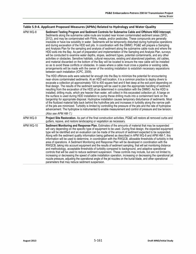
APM WQ‐8 Sediment Testing Program and Sediment Controls for Submarine Cable and Offshore HDD Intercept. Sediments along the submarine cable route are located near known contaminated sediment areas (SFEI, 2012), and may be contaminated with PAHs, metals, and/or pesticides. These compounds are generally insoluble or have low solubility in water. Sediments will be temporarily disturbed during hydroplow operations and during excavation of the HDD exit pits. In coordination with the DMMO, PG&E will prepare a Sampling and Analysis Plan for the sampling and analysis of sediment along the submarine cable route and where the HDD exits into the Bay. As part of preparation and implementation of the Sampling and Analysis Plan, surveys will be conducted to examine water depths, slopes, sediment types, potential contaminants, and any other activities or obstacles. Sensitive habitats, cultural resources, existing and abandoned pipelines, old cables, and material discarded on the bottom of the Bay will be located to ensure the new cable will be installed so as to avoid these conflicts or obstacles. In cases where a cable must cross a pipeline or existing cable, arrangements will be made with the owner of the existing installation to establish necessary separations between each installation (ICPC, 2009).
The HDD offshore exits were selected far enough into the Bay to minimize the potential for encountering near‐shore contaminated sediments. At an HDD exit location, it is a common practice to deploy divers to excavate a collection pit approximately 100 to 400 square feet and 6 feet deep at the exit point depending on final design. The results of the sediment sampling will be used to plan the appropriate handling of sediment resulting from the excavation of the HDD pit as determined in consultation with the DMMO. As the HDD is installed, drilling muds, which are heavier than water, will collect in this excavated collection pit. A barge on the surface is used during HDD installation to pump these drilling muds into a containment tank on the barge/ship for appropriate disposal. Hydroplow installation causes temporary disturbance of sediments. Most of the fluidized material falls back behind the hydroflow jets and increases in turbidity along the narrow path of the jets are minimized. Turbidity is limited by controlling the pressure of the jets and the rate of hydroplow advancement. The hydroplow is instrumented to enable measurement and control of pressure and tow tension.
(Also see APM HM‐7.)
APM WQ‐9 Project Site Restoration. As part of the final construction activities, PG&E will restore all removed curbs and gutters, repave, and restore landscaping or vegetation as necessary.
APM WQ-10 Sediment Monitoring and Response Plan. Estimates of the amounts of material that may be suspended will vary depending on the specific type of equipment to be used. During final design, the expected equipment type will be identified and an evaluation can be made of the amount of sediment expected to be suspended. Along with the sediment quality information being gathered as described in APM WQ-8 and APM HM-7, this information will be used to determine, in coordination with the RWQCB, allowable thresholds of turbidity in the area of operations. A Sediment Monitoring and Response Plan will be developed in coordination with the RWQCB, taking into account equipment and the results of sediment sampling, that will set monitoring distance and methodology, acceptable thresholds of turbidity compared to background, and adaptive operational controls that will be used to reduce sediment suspension. These controls may include, but are not limited to, increasing or decreasing the speed of cable installation operation, increasing or decreasing the operational jet nozzle pressure, adjusting the operational angle of the jet nozzles on the burial blade, and other operational parameters that may reduce sediment suspension.

PG&E Embarcadero-Potrero 230 kV Transmission Project INITIAL STUDY
Draft MND/Initial Study 5-162 August 2013
Table 5.9-4. Applicant Proposed Measures (APMs) Related to Hydrology and Water Quality
APM HM-1 Implementation of Hazardous Material and Emergency Response Procedures. PG&E will implement construction controls, training and communication to minimize the potential exposure of the public and site workers to potential hazardous materials during all phases of project construction. These construction practices include construction worker training appropriate to the site worker’s role (see APM HM‐3), and containment and spill control practices in accordance with the Stormwater Pollution Prevention Plan (see APM WQ‐1). If it is necessary to store chemicals, they will be managed in accordance with all applicable regulations. Material safety data sheets will be maintained and kept available on site, as applicable.
Soil that is suspected of being contaminated (on the basis of existing analytical data or visual, olfactory, or other evidence) and is removed during trenching or excavation activities will be segregated, tested, and if contaminated above hazardous levels, will be contained and disposed of offsite at a licensed waste facility. The presence of known or suspected contaminated soil will require testing and investigation procedures to be supervised by a qualified person, as appropriate, to meet state and federal regulations.
All hazardous materials and hazardous wastes will be handled, stored, and disposed of in accordance with all applicable regulations, by personnel qualified to handle hazardous materials. Practices during construction will include, but not be limited to, the following:
Proper disposal of potentially contaminated materials.
Site‐specific buffers for construction vehicles and equipment located near sensitive resources/receptors.
Emergency response and reporting procedures to address any potential hazardous material spills as described in PEA Section 3.9, Hydrology and Water Quality.
Stopping work at that location and contacting the CUPA (SFDPH Environmental Health Section; see PEA Section 3.8.2.1 above) immediately if unanticipated visual evidence of potential contamination or chemical odors are detected. Work will be resumed at this location after any necessary consultation and approval by the CUPA or other entities as specified by the CUPA.
For the O&M phase of the project, existing operational hazardous substance control and emergency response plans will be updated as appropriate to incorporate necessary modifications resulting from this project.
APM HM-2 Development and Implementation of a Health and Safety Plan. PG&E will prepare a project‐specific health and safety (H&S) plan prior to project construction. The purpose of the plan is to minimize potential safety hazards to site construction workers. The H&S plan will outline the project team H&S responsibilities; present job safety analyses, H&S procedures, and personal protective equipment requirements; establish worker training and monitoring requirements; and describe emergency response procedures relevant to project activities. Each contractor will be responsible for preparing and submitting to PG&E their own H&S Plan specific to their activities using the PG&E Plan for project‐specific information.
For the O&M phase of the project, existing H&S plans for Potrero Switchyard and Embarcadero Substation will be modified and adhered to as appropriate.
APM HM-3 Adherence to Applicable Site‐specific RMPs and SMPs. In addition to following its own project‐specific procedures during the construction phase, PG&E will adhere to any applicable site‐specific plans such as the SMP for the former Potrero Power Plant (see PEA Section 3.8.3.1), as well as the Maher Ordinance (see PEA Section 3.8.2.1).
APM HM-4 Emergency Spill Supplies and Equipment. Oil‐absorbent material, tarps, and storage drums will be available on the project site during construction and used to contain and control any minor releases of oil. In the event that excess water and liquid concrete escapes during pouring, it will be directed to lined and bermed areas adjacent to the borings, where the water will evaporate and the concrete will begin to set. Once the excess concrete has been allowed to set up, it will be removed and transported for disposal, according to applicable regulations.

PG&E Embarcadero-Potrero 230 kV Transmission Project INITIAL STUDY
August 2013 5-163 Draft MND/Initial Study
Table 5.9-4. Applicant Proposed Measures (APMs) Related to Hydrology and Water Quality
APM HM-5 Soil, Groundwater, and Underground Tank Characterization. In areas where existing data are not available, soil and groundwater sampling and potholing will be conducted in onshore project areas before construction begins. Appropriate handling, transportation, and disposal locations will be determined based on results of the analyses performed on soil and groundwater. In addition, results will be provided to contractor and construction crews to inform them about soil and groundwater conditions and potential hazards. The location, distribution, and/or frequency of the borings will give adequate representation of the conditions in the construction area.
If suspected hazardous substances are unexpectedly encountered during trenching or other construction activities (using indicators such as sheen, odor, soil discoloration), work will be stopped until the material or tank is properly characterized and appropriate measures are taken to protect human health and the environment. Appropriate personal protective equipment will be used and waste management will be performed in accordance with applicable regulations. If excavation of hazardous materials is required, the materials will be disposed of in accordance with applicable regulations. If necessary, groundwater will be collected during construction, contained, and disposed of in accordance with all applicable regulations.
If underground or aboveground storage tanks are found to be located along the project route and the route cannot be adjusted to avoid disturbance, the tanks will be removed prior to project construction. If it is determined that removal and disposal of tanks is necessary, a separate workplan describing the proper decommissioning and removal of the tanks and removal of any associated impacted soil will be prepared prior to removal.
APM HM-6 Horizontal Directional Drilling (HDD) Drilling Fluid and Cuttings Monitoring and Management. HDD operations will include provisions for monitoring for loss of drilling fluids. Spill response measures shall include reducing fluid pressures and thickening the fluid mixture. Both the drilling technique and early detection and response shall be used to minimize release of fluids to the environment. A Frac‐out Plan will be developed and prepared based on site specific conditions and specific contractor methods and equipment.
APM HM-7 Sediment Testing Program for Submarine Cable Installation. As discussed above, sediments along the submarine cable route are located near known contaminated sediment areas (SFEI, 2012), and a Sampling and Analysis Plan will be prepared in coordination with the Dredged Material Management Office (DMMO) of the U.S. Army Corps of Engineers. Sediment sampling shall be performed at the locations where the HDD emerges into the Bay, and the results would be considered and addressed prior to commencement of construction near these locations. Potential contaminants such as PAHs and heavy metals are generally insoluble or have low solubility in water. Conducting sediment analysis of samples before the installation of the submarine cable will establish baseline conditions along the project route. The sediment testing program will be used to develop appropriate construction control measures that may include controlling turbidity during construction through adjustment of hydroplow jet controls and flows, turbidity monitoring during construction in certain areas, and appropriate handling and disposal of any sediment that may be removed as part of the submarine transitions to HDD installation.
5.9.2 Environmental Impacts and Mitigation Measures
To determine if implementation of the Proposed Project would result in potentially significant impacts to surface water or groundwater resources, the project was reviewed using the CEQA Guidelines Appen-dix G Environmental Checklist pertaining to “Hydrology and Water Quality.” Applicable federal, state, and local laws, ordinances, regulations, and standards and their policies or guidelines applicable to the project site and surrounding area were also reviewed.
a. Would the project violate any water quality standards or waste discharge requirements?
LESS THAN SIGNIFICANT. During construction and operation of the Proposed Project, there is potential for violations of water quality standards or waste discharge requirements to occur as a result of accidental leaks, spills, or releases of hazardous or potentially hazardous materials, and due to the encountering of existing contamination in the project area. Complying with applicable water quality standards, including obtaining and adhering to required water quality permits, would offer sufficient protection to avoid significant adverse impacts to water quality. Applicable water quality standards and regulations are described above, in Section 5.9.1. Adherence to these standards and regulations collectively ensures that a suite of best management practices would be applied to minimize the potential for an accidental

PG&E Embarcadero-Potrero 230 kV Transmission Project INITIAL STUDY
Draft MND/Initial Study 5-164 August 2013
release of hazardous materials to occur, to quickly and effectively address any such leak, and to quickly and effectively respond to any existing contamination encountered during construction. In addition, APMs WQ-1 and HM-1 would include implementation of a project-specific SWPPP and Hazardous Mate-rial and Emergency Response Procedures, respectively, which would further avoid adverse water quality effects. Potential water quality effects associated with both construction and operation of the project are described here along with the permitting requirements.
Permitting Requirements
Water quality standards and waste discharge requirements applicable to the Proposed Project are pre-sented above in Section 5.9.1. The Proposed Project would be subject to multiple permits and approvals associated with the protection of water quality. The USACE is the responsible agency for regulating actions under CWA §404 and has the discretion to issue either case-by-case or general permits for potential effects to federally jurisdictional (Waters of the U.S.) inland waters, including the San Francisco Bay. Upon PG&E’s filing for permit review, the USACE would make a CWA §404 determination; CWA §404 coverage may be obtained through compliance of the project with an existing Nationwide Permit (NWP), or through issuance by the USACE of an Individual Permit specific to the project. NWP coverage is offered by the USACE as a method of streamlining the permitting process, where each NWP addresses a category of impacts, and a project must meet certain General Conditions in order to achieve NWP coverage. The project is likely to gain CWA §404 coverage through compliance with an existing NWP, pending USACE review of the project and associated impacts.
If the USACE requires and issues a permit under CWA §404, then the project would also require a CWA §401 Water Quality Certification from the San Francisco Bay RWQCB. Onshore portions of the project would need to obtain NPDES coverage through implementation of a SWPPP, in order to comply with CWA §402. In addition to these regulatory requirements, APMs WQ-1 through WQ-3 would further ensure implementation of a project-specific SWPPP to avoid adverse water quality effects. The need for Waste Discharge Requirements to be issued by the RWQCB per the Porter-Cologne Act would likely be satisfied by requirements of the CWA §401 permit, although this determination must be made by the San Francisco RWQCB. In permitting the Proposed Project through issuance of a CWA §401 permit and/or WDRs, the RWQCB must consider waters identified as impaired on the CWA §303(d) list and must estab-lish permitting requirements aimed to protect or improve the quality of §303(d)-listed waters.
Construction
The Proposed Project would construct a 3.5-mile-long transmission line Embarcadero Substation and Potrero Switchyard, including 0.6 miles to be installed underground in paved areas, 0.4 miles to be installed in horizontal directional drills (HDD) between the San Francisco Bay and onshore transition points, and 2.5 miles to be installed offshore in the San Francisco Bay. Each of these construction meth-odologies (underground, HDD, and offshore) are considered below, with their potential to result in adverse impacts to water quality such that water quality standards or waste discharge requirements could be violated.
Underground Transmission Line
Construction of the underground transmission line would include trenching and ground-disturbing activ-ities that could potentially result in several different types of water quality effects, summarized below.
Erosion and Sedimentation. Ground-disturbing activities that would occur during project construction, including excavation of the trench for the underground transmission line, would have the potential to

PG&E Embarcadero-Potrero 230 kV Transmission Project INITIAL STUDY
August 2013 5-165 Draft MND/Initial Study
result in soil erosion (transport) and sedimentation (delivery) that could degrade water quality. This impact would be most likely to occur if a storm event occurs during construction activities, while dis-turbed areas are exposed and/or have not yet been re-paved.
APM WQ-1 (Development and Implementation of a Stormwater Pollution Prevention Plan (SWPPP)) would be implemented as part of the project design, and includes a suite of best management practices (BMPs) to minimize or avoid adverse water quality impacts associated with erosion and sedimentation such as the use of straw wattles, erosion control blankets, and silt fences, as appropriate. In accordance with SWRCB requirements, the SWPPP would be maintained and updated throughout the project’s con-struction period. In addition, APM WQ-2 (Implementation of a Worker Environmental Awareness Pro-gram) would ensure that that all construction workers and field personnel associated with the project are appropriately trained on BMP implementation. Finally, APM WQ-9 (Project Site Restoration) would ensure that areas disturbed during project construction are appropriately restored following the com-pletion of construction. Potential water quality effects associated with erosion and sedimentation would be less than significant.
Hazardous Materials. Hazardous or potentially hazardous materials such as vehicle and equipment fuel could leak or be accidentally released during construction activities. The accidental release of hazardous materials could result in water quality degradation along the transmission line route, or in downstream areas, if such materials are allowed to migrate to a drainage channel. Potentially hazardous materials that may be used during construction include but are not limited to the following: diesel fuel, gasoline, lubricant oils, hydraulic fluid, antifreeze, transmission fluid, lubricant grease, cement slurry, and other fluids required for the operation of construction vehicles and equipment. Motorized equipment used at the project site during construction could leak hazardous materials, such as motor oil, transmission fluid, or antifreeze, due to inadequate or improper maintenance, unnoticed or unrepaired damage, improper refueling, or operator error.
Drainages in the project area are completely channelized and maintained for flood control; project con-struction activities would not occur directly within local drainage channels. Indirect water quality con-tamination could occur if a potentially harmful or hazardous material is released and is subsequently transported through runoff during a storm event. APM WQ-1 specifies BMPs to address water quality effects associated with stormwater runoff, while APM WQ-2 ensures that BMPs would be appropriately implemented. In addition, APMs WQ-3 (Implementation of Hazardous Material and Emergency Response Procedures) and WQ-4 (Emergency Spill Supplies and Equipment), both of which are also included as part of the project design, would ensure that any accidental release or spill of hazardous materials is appropriately addressed according to applicable regulations, and that construction workers are trained on how to handle such situations. Adverse water quality effects associated with hazardous materials would be less than significant.
Shallow Groundwater. Groundwater in the project area is known to occur at shallow depths, and shal-low groundwater could be encountered during ground-disturbing activities including trenching for instal-lation of the underground transmission line. Where shallow groundwater is encountered during project construction, dewatering of the area would be conducted using a pump or well points; the water would be pumped into containment tanks and tested for impairments, then discharged into the local storm sewer system when the water meets quality standards (p. 2-36 of PG&E, 2012). If acceptable water quality standards are not reached for discharge into the existing system, the water would be disposed of in accordance with state and federal standards (p. 2-35 of PG&E, 2012). As described above for the Clean Water Act, the NPDES permit process and associated SWPPPs are executed in order to adhere to water quality standards regulated under the CWA, including those associated with various toxic pollutants,

PG&E Embarcadero-Potrero 230 kV Transmission Project INITIAL STUDY
Draft MND/Initial Study 5-166 August 2013
total suspended solids, biological oxygen demand and pH (acidity/alkalinity measure scale). Also as previously described, the Proposed Project would implement a customized SWPPP and would be in full compliance with water quality standards and regulations, including the CWA. Potential water quality impacts associated with shallow groundwater would be less than significant.
Existing Contamination. As described in Section 5.9.1, existing contamination is known to occur in the soil and groundwater in the project area; if areas of existing contamination are encountered during ground-disturbing activities associated with the underground transmission line, such contaminants could be mobilized into the environment. However, implementation of the project design APMs men-tioned above identify BMPs to address stormwater runoff effects, which would also effectively avoid mobilization of contaminated areas potentially encountered during construction; these measures include APM WQ-1 (Development and Implementation of a SWPPP), APM WQ-3 (Implementation of Hazardous Material and Emergency Response Procedures), APM WQ-7 (Prevention of Contaminant Migration along HDD Route), and APM HM-1 (Implementation of Hazardous Material and Emergency Response Procedures).
In addition, APM WQ-5 (Soil Sampling / Wastewater and Groundwater Characterization) requires that soil sampling would be conducted prior to the onset of construction, and soil information would be pro-vided to construction crews to inform them about soil conditions and potential hazards. Any hazardous materials encountered during project construction would be handled in accordance with applicable reg-ulations. Soil borings conducted per APM WQ-5 would also identify where contaminated groundwater may be encountered, and dewatering activities would be applied as previously described. Potential water quality impacts associated with existing contamination would be less than significant.
Horizontal Directional Drilling (HDD)
HDD would be used to connect the onshore transmission line (installed underground, described above) and the offshore transmission line (installed beneath the floor of the San Francisco Bay Estuary, described below). On the land side, the HDD conduit would transition to duct bank conduits and into a transition manhole (p. 2-42 of PG&E, 2012). The offshore submarine cable would be pulled through the HDD conduits and spliced to a land cable type inside the transition manhole. The land cable type would then be routed to the substation within a duct bank system (p. 2-42 of PG&E, 2012). Several different types of water quality impacts could occur during this construction phase of the project, each of which is summa-rized below.
Erosion and Sedimentation. Similar to the erosion and sedimentation effects discussed above for the underground transmission line, ground-disturbing activities associated with HDD could result in water quality degradation from erosion and sedimentation. Ground-disturbing activities associated with HDD would include but are not necessarily limited to the following: excavate the HDD pits and insert the HDD rigs; drill the HDD bore holes; excavate an adjacent three-foot by five-foot pit at the exit of the bore hole to capture mud (which is pumped up to a barge and disposed of per appropriate regulations); and resto-ration of the area to pre-construction conditions. Silt fencing, erosion control, and containment devices would be implemented around the drilling equipment in order to prevent loose soils and stormwater runoff from leaving the site, as described in the Project Description, and as would be required by the Project’s SWPPP, also described in APM WQ-1 (p. 2-42 of PG&E, 2012).
APM WQ-1 would ensure implementation of erosion control BMPs through a project-specific SWPPP, APM WQ-2 would ensure proper training of construction workers and field personnel, and APM WQ-9 would ensure that areas disturbed during project construction are appropriately restored. Potential water quality effects associated with erosion and sedimentation from HDD operations would be less than significant.
PG&E Embarcadero-Potrero 230 kV Transmission Project INITIAL STUDY
August 2013 5-167 Draft MND/Initial Study
Hazardous Materials. Hazardous or potentially hazardous materials such as vehicle and equipment fuel could leak or be accidentally released during construction activities, as described above for the under-ground transmission line segment of the project. Onshore, visqueen (plastic sheeting) would be placed under the drill rig and any support equipment that could have a potential for a hydraulic, fuel, or oil leak (p. 2-42 of PG&E, 2012). In addition, HDD activity could impact bay water quality through loss of drilling fluids, and/or disruption of bay bottom sediments where the borehole emerges (disruption of bay sediments is addressed below, in the discussion of submarine cable installation).
HDD could also result in frac-out, which is when the ground fractures at the borehole location, allowing drilling fluid to escape to the surface; this situation may occur if the borehole becomes obstructed dur-ing drilling operations, or if pressure within the borehole is too great. The use of proper drilling tech-niques and careful monitoring of drilling operations should eliminate the potential for frac-out to occur. If frac-out were to occur in the bay, it is expected that drilling materials would remain at the frac-out location because they are denser than water, and therefore would not be able to rise to the surface or become suspended in waters of the bay. (p. 3.9-16 of PG&E, 2012)
APM WQ-6 (Horizontal Directional Drilling (HDD) Monitoring and Management) specifically addresses HDD activities, to ensure that appropriate BMPs are implemented to avoid potential adverse effects to water quality, including monitoring for loss of drilling fluids, spill containment measures, and spill response measures. In addition, APM WQ-7 (Prevention of Contaminant Migration along HDD Route) would further avoid impacts by preventing contaminants along the HDD route from leaching to the shoreline or the bay via the boreholes of the HDD. APMs WQ-3 and WQ-4 would also ensure that any accidental release or spill of hazardous materials is appropriately addressed. Potential impacts to water quality associated with hazardous materials and HDD operations would be less than significant.
Increased Turbidity. The Proposed Project would involve clamshell dredging activities to create HDD exit pits, using a clamshell dredger excavating from a work barge anchored above the exit points. The sides of the offshore pits would be sloped sufficiently such that shoring would not be necessary. Dredged material would be brought to the surface and deposited on/in a barge for disposal and/or reuse, depend-ing upon the quality of the material. The action of excavating material from the floor of the bay and transferring it to the surface would likely result in temporarily increased turbidity and suspended sedi-ments in the area.
APMs WQ-8 (Sediment Testing Program and Sediment Controls for Submarine Cable and Offshore HDD Intercept) and WQ-10 (Sediment Monitoring and Response Plan) would be implemented as part of the project design, in order to minimize adverse water quality effects associated with increased turbidity and sediment mobilization, as summarized below.
APM WQ-8 ensures that PG&E would coordinate with the DMMO to develop a Sampling and Analysis Plan to assess the quality of sediments to be excavated. This APM requires that specific sediment testing, removal, handling, and disposal procedures are conducted in coordination with the DMMO, as well as a Dredge Material Reuse/Disposal authorization acquired from the DMMO.
APM WQ-10 ensures that PG&E will coordinate with the RWQCB to identify allowable thresholds of turbidity in the project’s construction area. In addition, a Sediment Monitoring and Response Plan will be developed with the RWQCB, and will set monitoring distance and methodology, as well as adaptive operational controls that will be used to reduce sediment suspension.
Conclusion. With APMs WQ-8 and WQ-10 incorporated into the project design, potential water quality impacts associated with increased turbidity during HDD operations would be less than significant.

PG&E Embarcadero-Potrero 230 kV Transmission Project INITIAL STUDY
Draft MND/Initial Study 5-168 August 2013
Submarine Cable Installation
The offshore portion of the Proposed Project would be constructed using hydroplow methods, where high-pressure water would be used to cut an approximately one-foot-wide trench where the transmis-sion line would be buried. The submarine cables would be installed at a depth ranging between approxi-mately 6 to 10 feet below the floor of the bay. In order to accomplish this, the hydroplow would be dragged along the bottom of the bay by a barge on the water’s surface. The cable to be buried would be fed to the hydroplow by the barge and placed directly in the trench as the hydroplow forms it. Sedi-ments displaced by the hydroplow become fluidized, and would largely fall back into the trench, on top of the cable. No additional disturbance would be required to bury the cable. Each of the three sub-marine cables would require one to 1.5 days for hydroplowing, as well as one day before and after the hydroplowing operations to mobilize and demobilize; therefore, hydroplowing operations for the entire project could conservatively require up to 10.5 days. Following is a discussion of potential water quality impacts that could occur as a result of hydroplowing activities.
Hazardous Materials. As with other construction activities, hydroplowing would include the use of haz-ardous materials required to operate construction equipment and machinery. The types of equipment and machinery to be used during hydroplowing are commonly used in the bay, and would not introduce new or unusual hazardous materials to the area. Compliance with CWA §401 would ensure that appro-priate BMPs are implemented to protect water quality from hazardous materials effects. In addition, APMs WQ-1 through WQ-4 require the implementation of BMPs to avoid adverse water quality effects, including as related to the accidental release of hazardous materials.
Increased Turbidity. Hydroplow operations would cause localized increases in turbidity, or the concen-tration of suspended solids in the water. This disturbance may be comparable to the effects of common bay activities on increased turbidity, such as shallow-water vessel operation or minor dredging activities. Disturbance of sediments is not unusual in the bay. Turbidity is limited by controlling the pressure of the jets and the rate of hydroplow advancement, with the hydroplow instrumented to enable measurement and control of pressure. Increased turbidity associated with hydroplow operations is estimated to disperse within approximately 15 feet. In addition, the Sediment Monitoring and Response Plan required per APM WQ-10 would ensure coordination between PG&E and the San Francisco Bay RWQCB to set monitoring distances and methodologies, as well as to set adaptive operational controls for turbidity. As stated in Section 3.3.19 (Turbidity) of Chapter 3 (Water Quality Objectives) of the Water Quality Control Plan for the San Francisco Bay Basin, which is administered by the RWQCB, waters shall be free of changes in turbidity that cause nuisance or adversely affect beneficial uses, and increases from normal background light penetration or turbidity relatable to waste discharge shall not be greater than 10 percent in areas where natural turbidity is greater than 50 NTU (SFB RWQCB, 2011). Coordination with the RWQCB and implementation of the Sediment Monitoring and Response Plan ensure that potential impacts to water quality associated with turbidity from the submarine cable installation would be less than significant.
Mobilization of Contaminants. The Proposed Project would be installed in the sediment on the floor of the bay, which could mobilize contaminants from the sediment to the water column. As discussed in Section 5.9.1 and shown in Table 5.9-3, sediments in the bay are affected by existing contamination, pri-marily in the form of PAHs, metals, and pesticides. Known areas of sediment contamination are located along the proposed route for the submarine cables. Most notably, the total concentration of PAHs is well above the probable effects level at the closest Regional Monitoring Program site, and above thresh-old effects levels at sites to the north and south of the project. Mercury concentrations have also been
PG&E Embarcadero-Potrero 230 kV Transmission Project INITIAL STUDY
August 2013 5-169 Draft MND/Initial Study
measured at very high levels in the project area, and high PCB concentrations have been measured throughout the bay.
The disturbance of sediments during hydroplowing operations would result in re-suspension of both sediment and contaminants in the water column. Sediment contamination is known to be more concen-trated in shallower waters, where urban runoff is more concentrated. Sediments in the bay are also dynamic, and mobilize in response to human activities such as dredging and vessel operation, as well as natural conditions such as winter storms. However, if hydroplowing operations mobilize existing con-taminants in bay sediments, adverse water quality effects could occur. Hydroplowing would not increase the concentrations of toxic pollutants in sediments of the bay, but may result in temporary increases in the concentration of toxic pollutants in the water column along the 2.5-mile offshore route, due to the re-suspension of contaminated sediments (if contaminated sediments are located along the cable align-ments). This increased concentration could indirectly affect aquatic life, if ingested by species in the water. Most aquatic life in the project area would be expected to move away from the area of hydro-plowing operations, and would not be adversely affected by the immediate disturbance. If species move back into the project area before re-suspended contaminated sediments have settled again, they may be exposed to increased concentrations of local contaminants. Section 5.4, Biological Resources, dis-cusses potential impacts to marine life.
The Basin Plan for the San Francisco Bay Region stipulates (Section 3.3.12), “Controllable water quality factors shall not cause a detrimental increase in the concentrations of toxic pollutants in sediments or aquatic life,” and “[t]he suspended sediment load and suspended sediment discharge rate of surface waters shall not be altered in such a manner as to cause nuisance or adversely affect beneficial uses” (SFB RWQCB, 2011). The San Francisco Bay RWQCB is responsible for implementing the Basin Plan, as well as for issuing Water Quality Certification permits per CWA §401 of the Clean Water Act and Waste Discharge Requirement permits per the Porter-Cologne Water Quality Control Act. As previously mentioned, the RWQCB permitting process would establish compliance with CWA §401 requirements, which would include the Waste Discharge Requirement permit. The RWQCB would ensure through its permit requirements that the Proposed Project would be consistent with the Basin Plan.
In order to minimize adverse water quality effects associated with the mobilization of contaminated sediments, APM WQ-8 would be implemented as part of the project design. In accordance with this APM, PG&E would work in coordination with the DMMO to develop a Sampling and Analysis Plan to assess the quality of sediments along the specific cable routes, and to conduct surveys to examine water depth, slopes, sediment types, potential contaminants, and any other activities or obstacles along the cable routes; these actions would occur regardless of any minor alignment modifications incorporated during the final design and engineering process. As described above, the DMMO was created as part of the LTMS Program, and is comprised of multiple resource agencies that work together to facilitate the processing of dredging permit applications within existing laws, regulations, and policies. In requiring the collaborative development of a Sediment Testing Program with the DMMO, APM WQ-8 would ensure that temporary water quality impacts associated with mobilizing contaminated sediments during hydro-plowing activities would be less than significant.
Conclusion. The APMs discussed above and presented in Table 5.9-4 would be implemented as part of the project design in association with all applicable construction activities, including the Potrero Switch-yard improvements. Construction of the Proposed Project would not result in significant water quality impacts, and would be in compliance with all applicable water quality standards and waste discharge requirements.

PG&E Embarcadero-Potrero 230 kV Transmission Project INITIAL STUDY
Draft MND/Initial Study 5-170 August 2013
Operation and Maintenance
In accordance with APM WQ-9, the project area would be restored following the completion of con-struction. Monitoring of the Proposed Project facilities would largely be conducted using the existing PG&E computer system by a telecommunication circuit. Regular inspection of project facilities and infra-structure would be conducted, and repairs to project facilities would be conducted on an as-needed basis. Harmful or potentially hazardous materials including vehicle fuels and lubricants would be used for standard operation and maintenance practices. Adverse impacts to water quality could occur if such materials are accidentally spilled or leaked along the project route. If not properly addressed and cleaned up, a spill or leak of hazardous materials could wash into nearby drainages or infiltrate soil to the water table. However, as part of the project design, PG&E would prepare a Spill Prevention, Control, and Countermeasure (SPCC), and/or modify existing SPCC plan(s) applicable to the project, and such plan or modifications would include engineering and operational methods for preventing, containing, and con-trolling potential releases, as well as provisions for quick and safe cleanup. The existing SPCC oil contain-ment basin and stormwater collection facilities at the Potrero 115 kV Switchyard (near the intersection of Illinois and 23rd Streets) would be used to the extent feasible. Storm water transport would be either by gravity flow (surface or piped), or pumping may be required depending on final hydraulic design. Provisions for oil/water separation and small amounts of additional temporary water storage (500 to 1,000 gallons) may be installed for water transference from the new 230 kV switchyard to the existing stormwater collection system. Potential impacts to water quality during operation and maintenance of the project would be less than significant, and the project would be consistent with all applicable water quality standards and waste discharge requirements.
b. Would the project substantially deplete groundwater supplies or interfere substantially with groundwater recharge such that there would be a net deficit in aquifer volume or a lowering of the local groundwater table level (i.e., the production rate of pre-existing nearby wells would drop to a level which would not support existing land uses or planned uses for which permits have been granted)?
LESS THAN SIGNIFICANT. Groundwater supplies could be adversely affected through any of the following means: direct consumption of groundwater resources; indirect depletion of groundwater supplies such as conducting dewatering activities where the water is not returned to the subsurface; and/or introduce substantial new impervious areas or increased soil compaction such that the rate of infiltration of storm-water runoff to the subsurface is substantially affected. Each of these potential circumstances is dis-cussed below.
Water Supply Source
The Proposed Project would require a water supply of approximately two 2,000 gallon truckloads per day for dust control during construction, prior to and during ground-disturbing activities. For instance, storage piles would be kept wet and/or treated with a chemical dust suppressant; also, equipment would be washed down prior to moving from the work area onto public roads, and “wet sweeping” would be used to clean visible track-outs from the paved public roads. PG&E proposes no specific water source for these uses, but the water supply in the project area is provided by the San Francisco Public Utilities Commission (SFPUC). PG&E would be likely to obtain water supply services for the Proposed Project through coordination with the SFPUC. Consistent with Ordinance 175-91, enacted by the City and County of San Francisco in 1991, PG&E would use non-potable water for dust control and soil com-paction activities where feasible. Local groundwater resources in the Downtown San Francisco Ground-water Basin are generally limited to non-potable uses due to historic industrial development, high salinity, and density of contaminated sites (p. 3.9-9 of PG&E, 2012). Although a groundwater budget for this basin

PG&E Embarcadero-Potrero 230 kV Transmission Project INITIAL STUDY
August 2013 5-171 Draft MND/Initial Study
is not currently available, the amount of water in storage is generally considered to be stable. Recycled water would likely be obtained from the SFPUC. Water supply requirements associated with the Pro-posed Project would be short-term and temporary, limited to the project’s construction period. As such, the Proposed Project would not substantially deplete groundwater supplies as a result of water supply requirements.
Dewatering Activities
Due to the relatively shallow depth to groundwater in the project area, and the proposed trenching and excavation activities that would occur during implementation of the underground transmission line and HDD operations, it is likely that groundwater would be encountered during construction activities. If this occurs, dewatering activities would be implemented and; the water would be pumped into containment tanks and tested for impairments, then discharged into the local storm sewer system when the water meets quality standards, previously discussed (p. 2-36 of PG&E, 2012). If acceptable water quality stand-ards are not reached for discharge into the existing system, the water would be disposed of in accord-ance with state and federal standards (p. 2-36 of PG&E, 2012). As such, groundwater that is removed from the subsurface during dewatering operations may not be returned to the subsurface. However, as described in Section 5.9.1, approximately half of all recharge to the Downtown San Francisco Ground-water Basin occurs through leakage from municipal water and sewer pipes; this recharge occurs regardless of project-related dewatering activities, and the project would not substantially deplete groundwater supplies as a result of dewatering.
New Impervious Areas / Increased Soil Compaction
Components of the Proposed Project with the potential to result in new impervious areas and increased soil compaction are restricted to onshore project features, including the underground transmission line segment, onshore HDD work areas, and improvements at the Potrero Switchyard. The underground portions of the transmission line would be routed under existing streets where soil has been historically disturbed, compacted, and paved. Soil in the vicinity of the trench would not be significantly modified from that already underlying the streets. Regarding the HDD work areas, project construction would introduce new impervious areas, but such areas would be temporary with metal plates covering any excavated areas outside of construction hours. Construction would also increase soil compaction across the work area sites due to the use of heavy equipment and machinery. However, new impervious areas would be temporary in nature, limited to the construction period, and in accordance with APM WQ-9, project work areas would be restored following the completion of construction. Improvements at the Potrero Switchyard would also introduce new impervious area and increased soil compaction, with pro-visions for stormwater mitigation or control (such as pervious pavement, detention, and/or landscaping) depending on City building code requirements. The effects would be site-specific and restricted to the boundary of the new switchyard area. Considering the urbanized nature of the surrounding area, and the fact that surface water infiltration only provides a fraction of recharge to the Downtown San Fran-cisco Groundwater Basin, which receives most of its recharge from leaking underground municipal water and sewer pipes, improvements at the Potrero Switchyard would not adversely affect ground-water recharge or aquifer volume.
Conclusion. The Proposed Project would not substantially deplete groundwater supplies or interfere substantially with groundwater recharge such that there would be a net deficit in aquifer volume or a lowering of the local groundwater table level; impacts to groundwater resources would be less than significant.

PG&E Embarcadero-Potrero 230 kV Transmission Project INITIAL STUDY
Draft MND/Initial Study 5-172 August 2013
c. Would the project substantially alter the existing drainage pattern of the site or area, including through the alteration of the course of a stream or river, in a manner, which would result in substantial erosion or siltation on or off site?
LESS THAN SIGNIFICANT. The project would not alter the course of a stream or river. Increases in the rate or amount of surface water runoff could occur if the project introduces substantial new areas of impervi-ous surfaces, if the project results in substantially increased soil compaction, and/or if the project results in new discharge of runoff water to the ground surface. Onshore ground-disturbing activities associated with the project would occur in previously disturbed areas that are predominately paved. As discussed in the Biological Resources section, a number of trees would be removed with the Project; no other vegetation removal would occur due to the project, and the project would not introduce substantial new areas of impervious surfaces. As described above, the project would result in minimal new impervi-ous areas and increased soil compaction. The project may result in the discharge of dewatered ground-water to the existing stormwater system, but would not discharge runoff water to the ground surface. APM WQ-1 includes implementation of project-specific BMPs to minimize or avoid adverse effects associ-ated with stormwater runoff and drainage pattern alterations. The project would not introduce drainage pattern alterations that would result in substantial erosion or siltation, on- or off-site, and potential impacts would be less than significant.
d. Would the project substantially alter the existing drainage pattern of the site or area, including through the alteration of the course of a stream or river, or substantially increase the rate or amount of surface runoff in a manner that would result in flooding on or off site?
LESS THAN SIGNIFICANT. As described above, the Proposed Project would not alter the course of a stream or river, and would not substantially alter the existing drainage pattern of the site or area. The project could increase the rate or amount of surface runoff associated with site-specific increases in impervious areas and soil compaction at the new Potrero Switchyard, but such effects would be temporary and highly site-specific, and would be minimized or avoided through implementation of BMPs required per APMs included as part of the project design, such as the SWPPP that would be developed per APM WQ-1. The Proposed Project would not substantially alter existing drainage patterns, and potential effects associated with flooding on- or off-site would be less than significant.
e. Would the project create or contribute runoff water which would exceed the capacity of existing or planned stormwater drainage systems to provide substantial additional sources of polluted runoff?
LESS THAN SIGNIFICANT. This significance criterion addresses two potential issues: the capacity of storm-water drainage systems, and the quality of stormwater runoff from the project area. As discussed under previous significance criteria, groundwater encountered during installation of the underground portion of the proposed transmission line would be dewatered and stored in containment vessels (Baker tanks) until it is determined whether the water quality would permit discharge to the City’s combined sewer system, or whether the water would need to be trucked to an appropriate disposal facility. Water would be disposed of in accordance with state and federal standards. Stormwater collected at the proposed Potrero 230 kV Switchyard would be either transferred by pumped pressure piping or gravity flow (sur-face or piped, implemented during the Project construction period) to the existing 115 kV switchyard SPCC oil containment basin (near the intersection of Illinois and 23rd Streets), or after provisions for oil/water separation, directly into the stormwater collection system at the new 230 kV switchyard. Small amounts of additional temporary water storage (500 to 1,000 gallons) may be used as part of the water transference system from the new 230 kV switchyard to the existing 115 kV switchyard area. Final design of the temporary water storage would be dependent on the results of the geotechnical investiga-

PG&E Embarcadero-Potrero 230 kV Transmission Project INITIAL STUDY
August 2013 5-173 Draft MND/Initial Study
tion and possible chemical analysis of the site soil. No runoff water would be contributed by the project such that the capacity of existing or planned stormwater drainage systems would be exceeded. With regards to the project’s potential to provide a source of polluted runoff, water quality considerations are discussed under significance criterion (a), and have been determined to be less than significant. Poten-tial impacts of the project associated with the contribution of excess runoff water and/or polluted runoff would be less than significant.
f. Would the project otherwise substantially degrade water quality?
NO IMPACT. All potential water quality impacts associated with the Proposed Project are captured in the impact discussions provided above.
g. Would the project place housing within a 100-year floodplain, as mapped on a federal Flood Hazard Boundary or Flood Insurance Rate Map or other flood hazard delineation map?
NO IMPACT. The project does not include construction of any housing units, and would not alter existing flood hazards in the area such that existing housing units would be placed within a 100-year floodplain. No impact would occur.
h. Would the project place within a 100-year floodplain structures that would impede or redirect flood flows?
NO IMPACT. Portions of the project’s HDD segments cross through a FEMA-designated Special Flood Hazard Area. As previously described, HDD components are installed underground, to connect offshore facilities with onshore facilities. These components do not include any structures with the potential to impede or redirect flood flows in the 100-year floodplain.
i. Would the project expose people or structures to a significant risk of loss, injury or death involving flooding, including flooding as a result of the failure of a levee or dam?
NO IMPACT. The Proposed Project would not alter any existing flood-related hazards in the area, and would not expose people or structures to a significant risk of loss, injury, or death associated with flood-ing. The project would have no potential to cause the failure of a levee or dam, and would not introduce associated flooding hazards. No impact would occur.
j. Would the project cause inundation by seiche, tsunami, or mudflow?
LESS THAN SIGNIFICANT. The Proposed Project is not located within proximity of a standing body of water that could produce a seiche in response to a strong seismic event, and is located in a relatively flat area not subject to mudflow hazards; therefore, the project would have no potential to cause inundation by seiche or mudflow.
Earthquakes off the California coast south of Cape Mendocino are mainly on strike-slip faults, including the San Andreas Fault in the project area. The lateral fault movements of strike-slip faults do not create the vertical offsets that cause tsunamis. Therefore, the crustal faults in the Bay Area that are more likely to damage the existing transmission system would rarely generate significant tsunamis, because water overlying the ocean floor is not likely to be thrust upward or dropped downward (PG&E, 2013).
However, earthquakes from the subduction zone off the California, Oregon, and Washington coast could generate tsunamis that reach California’s coastline. Portions of the proposed facilities, including the Potrero Switchyard, are located within a Tsunami Hazard Area identified by CEMA (CEMA, 2013). There-fore, project facilities would be subject to inundation by a tsunami, should a strong seismic event occur and trigger a tsunami event in the ocean. However, implementation of the project would not alter exist-

PG&E Embarcadero-Potrero 230 kV Transmission Project INITIAL STUDY
Draft MND/Initial Study 5-174 August 2013
ing potential for inundation by tsunami, and would introduce facilities that are consistent with existing infrastructure and facilities in the project area. If a tsunami event does occur after implementation of the project, the presence of the project would not alter the potential of such an event to result in adverse effects. Therefore, potential for the project to cause adverse effects associated with inundation by a tsunami would be less than significant.