4.8 hydrology/water quality - planning.lacity.org i/13_sec4-8... · this section of the eir...
TRANSCRIPT
4.8-1
CHAPTER 4 Environmental Analysis SECTION 4.8 Hydrology/Water Quality
San Pedro Community Plan EIR State Clearinghouse No. 2008021004
City of LA EIR No. ENV-2009-1558-EIR CPC No. CPC-2009-1557-CPU
Draft EIR August 2012
4.8 HYDROLOGY/WATER QUALITY This section of the EIR analyzes the potential environmental effects on hydrology/water quality from implementation of the proposed plan. It addresses stormwater runoff and urban pollutants, flood hazards (including sea level rise), drainage, and groundwater resources. A regulatory framework is also provided in this section, describing applicable agencies and regulations related to hydrology/water quality. The evaluation of the proposed plan’s effects on water supplies is included in Section 4.14 (Utilities/Service Systems).
No comments specifically addressing such issues as drainage, flooding, or water quality were received in response to the Notice of Preparation (NOP) circulated for the proposed San Pedro Community Plan (proposed plan). However, the issue of water supply was noted as a concern by a few individuals. The reader is referred to Section 4.14 for water supply impacts.
Baseline information for the analysis was compiled from a review of data and reports published by state agencies, environmental documents for projects in the vicinity, as well as information compiled and evaluated by the City of Los Angeles in conjunction with its stormwater management and hazard mitigation programs. These sources include the California Department of Water Resources, City of Los Angeles Water Quality Compliance Master Plan for Urban Runoff, Federal Emergency Management Agency (FEMA) floodplain mapping, the City of Los Angeles Hazard Mitigation Plan, General Plan, and Municipal Code, and other published materials. Full reference-list entries for all cited materials are provided in Section 4.8.5 (References).
4.8.1 Environmental Setting
Climate and Physiography The San Pedro CPA encompasses approximately 3,674 acres in the southern portion of the City of Los Angeles. Regional climate is semi-arid and is characterized by warm summers, mild winters, infrequent seasonal rainfall, moderate daytime onshore breezes, and moderate humidity. Annual average temperature in Los Angeles is 65.0°F, with average temperatures ranges from approximately 55.0°F in winter to 75.0°F in the summer. Summer rainfall is minimal and generally limited to scattered thundershowers in coastal regions. Average rainfall in Los Angeles is approximately 14 inches annually.83
The CPA is located at the southern edge of the Los Angeles coastal plain, adjacent to the eastern portion of the Palos Verdes Peninsula. Topographically, the eastern portion of the CPA is mostly flat to gently undulating, while the western portion of the CPA is gently to moderately hilly. Although the majority of the San Pedro CPA is developed urban land, a few areas of natural or undeveloped open space remain. To the south, open space is provided by the beaches along the Pacific Ocean and shoreline recreation areas; and to the east by the harbor. These areas are predominantly located around the borders, including coastal bluffs and hill slopes to the west and north along the border of Rancho Palos Verdes.
84
83 This DEIR, Section 4.2 (Air Quality) and Section 4.5 (Geology/Soils and Mineral Resources).
84 This DEIR, Section 4.2 (Air Quality) and Section 4.5 (Geology/Soils and Mineral Resources).
4.8-2
CHAPTER 4 Environmental Analysis SECTION 4.8 Hydrology/Water Quality
San Pedro Community Plan EIR State Clearinghouse No. 2008021004
City of LA EIR No. ENV-2009-1558-EIR CPC No. CPC-2009-1557-CPU
Draft EIR August 2012
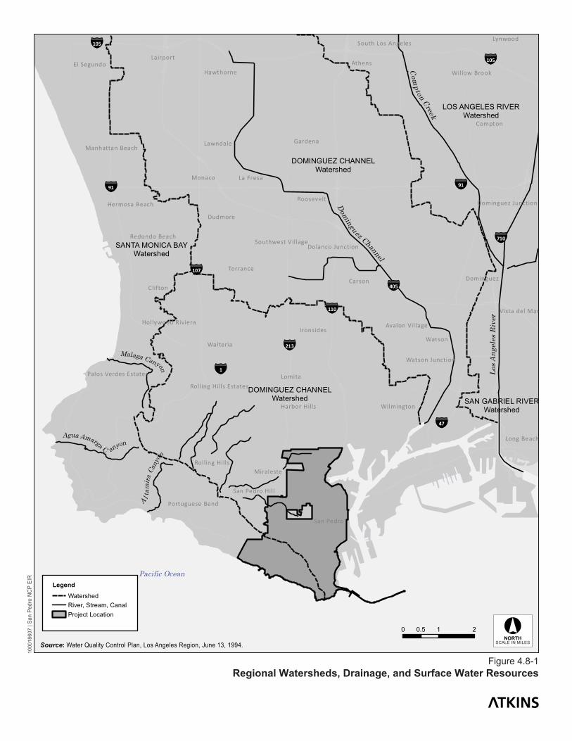
Surface Water Resources Watershed The San Pedro CPA is in the Dominguez Channel watershed (State Water Resources Control Board [SWRCB] Hydrologic Unit 405.12), which has an area of 133 square miles. Rather than being defined by the natural topography of its drainage area, the Dominguez Channel watershed boundary is defined by a complex network of storm drains and smaller flood control channels that are within or pass through Inglewood (on the north), Compton (on the east), Torrance (on the west), and, on the south, the federal breakwaters of Los Angeles and Long Beach Harbors (LA/LB Harbors).85 The Dominguez Channel watershed is also termed a “management area” that includes some land with storm drains that do not empty into Dominguez Channel, but is geographically connected with the land that does drain into the channel. This area includes the communities of San Pedro and Wilmington.86
There are five subwatersheds: two of these (the Upper Channel and the Lower Channel) drain directly into the Dominguez Channel. The remaining subwatersheds include retention basins, Machado Lake, and LA/LB Harbors. The Harbors subwatershed, comprising portions of the cities of Los Angeles, Long Beach, Rancho Palos Verdes, and Rolling Hills, has an area of 36.7 square miles and drains directly into the LA/LB Harbors.
87
Most land in the watershed is developed (93 percent). Approximately 62 percent of stormwater runoff from these lands drains to the Dominguez Channel.
88 Average annual runoff watershed-wide is approximately 28 billion gallons; the City of Los Angeles contributes about 2.8 billion gallons (10 percent).89
Surface Water Resources
There are no surface waters within the CPA. However, as noted above, there are major surface water resources in the vicinity of the CPA (see Figure 4.8-1 [Regional Watersheds, Drainage, and Surface Water Resources]).
Surface Water Quality Water quality in the LA/LB Harbor subwatershed is influenced by a number of factors including climate, circulation, biological activity, surface runoff, effluent discharges, and accidental discharges of pollutants related to shipping activities. Water column contaminants include metals (particularly cadmium, chromium, copper, lead, mercury, nickel, silver, and zinc), oil and grease, chlorinated hydrocarbons
85 Los Angeles Harbor Department, San Pedro Waterfront Project Draft EIS/EIR (2008), Section 3.14 (Water Quality, Sediments, and Oceanography). 86 Los Angeles Department of Public Works, Bureau of Sanitation, Watershed Protection Division, Water Quality Compliance Master Plan for Urban Runoff (May 2009), Chapter 2. 87 Los Angeles Harbor Department, San Pedro Waterfront Project Draft EIS/EIR (2008), Section 3.14 (Water Quality, Sediments, and Oceanography). 88 Los Angeles Harbor Department, San Pedro Waterfront Project Draft EIS/EIR (2008), Section 3.14 (Water Quality, Sediments, and Oceanography). 89 Los Angeles Department of Public Works, Bureau of Sanitation, Watershed Protection Division, Water Quality Compliance Master Plan for Urban Runoff (May 2009), Chapter 2.
A l tam
ira C
anyo
n
Agua Amarga C anyon
Malaga Canyon
DOMINGUEZ CHANNELWatershed
LOS ANGELES RIVERWatershed
SANTA MONICA BAYWatershed
DOMINGUEZ CHANNELWatershed SAN GABRIEL RIVER
Watershed
Pacific Ocean
Los A
ngel
es R
iver
Dominguez Channel
Com
pton Creek
Watts
Lomita
Watson
Carson
Monaco
Athens
Lennox
Clifton
Dudmore
Gardena
Compton
Lynwood
Walteria
Torrance
La Fresa
Lawndale
Lairport
San Pedro
Miraleste
Ironsides
Dominguez
Roosevelt
Hawthorne
Long Beach
Wilmington
El Segundo
Harbor Hills
Willow Brook
Rolling Hills
Vista del Mar
Redondo Beach
Hermosa Beach
San Pedro Hil l
Avalon Vil lage
Portuguese Bend
Watson Junction
Manhattan Beach
Dolanco Junction
Hollywood Riviera
Southwest Village
South Los Angeles
Dominguez Junction
Palos Verdes Estates
Rolling Hills Estates
Legend
WatershedRiver, Stream, CanalProject Location
0 1 20.5
Figure 4.8-1Regional Watersheds, Drainage, and Surface Water Resources
1000
1860
7 | S
an P
edro
NC
P EI
R
Source: Water Quality Control Plan, Los Angeles Region, June 13, 1994. SCALE IN MILES
4.8-4
CHAPTER 4 Environmental Analysis SECTION 4.8 Hydrology/Water Quality
San Pedro Community Plan EIR State Clearinghouse No. 2008021004
City of LA EIR No. ENV-2009-1558-EIR CPC No. CPC-2009-1557-CPU
Draft EIR August 2012
(DDT and DDE), and polychlorinated biphenyls (PCBs). Other water quality parameters such as phosphates and nitrates change from day to day and are influenced by factors that include biological processes, wastewater discharge, and stormwater runoff. The Los Angeles Harbor, as an enclosed water body, has different seasonal and spatial variation in nutrient concentration from what is observed outside the breakwater. Depending on location, depth, and season, nutrients in the harbor may vary in concentration by several orders of magnitude. Nutrient concentrations were high during periods of high stormwater runoff.90
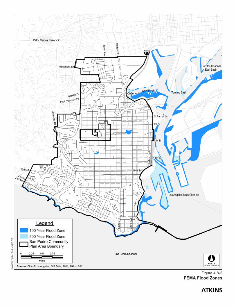
Flood Hazards
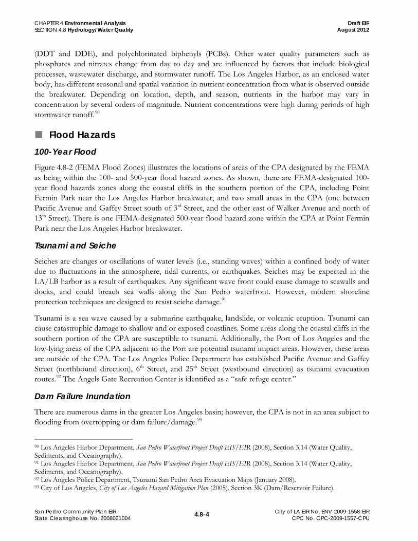
100-Year Flood Figure 4.8-2 (FEMA Flood Zones) illustrates the locations of areas of the CPA designated by the FEMA as being within the 100- and 500-year flood hazard zones. As shown, there are FEMA-designated 100-year flood hazards zones along the coastal cliffs in the southern portion of the CPA, including Point Fermin Park near the Los Angeles Harbor breakwater, and two small areas in the CPA (one between Pacific Avenue and Gaffey Street south of 3rd Street, and the other east of Walker Avenue and north of 13th Street). There is one FEMA-designated 500-year flood hazard zone within the CPA at Point Fermin Park near the Los Angeles Harbor breakwater.
Tsunami and Seiche Seiches are changes or oscillations of water levels (i.e., standing waves) within a confined body of water due to fluctuations in the atmosphere, tidal currents, or earthquakes. Seiches may be expected in the LA/LB harbor as a result of earthquakes. Any significant wave front could cause damage to seawalls and docks, and could breach sea walls along the San Pedro waterfront. However, modern shoreline protection techniques are designed to resist seiche damage.91
Tsunami is a sea wave caused by a submarine earthquake, landslide, or volcanic eruption. Tsunami can cause catastrophic damage to shallow and or exposed coastlines. Some areas along the coastal cliffs in the southern portion of the CPA are susceptible to tsunami. Additionally, the Port of Los Angeles and the low-lying areas of the CPA adjacent to the Port are potential tsunami impact areas. However, these areas are outside of the CPA. The Los Angeles Police Department has established Pacific Avenue and Gaffey Street (northbound direction), 6th Street, and 25th Street (westbound direction) as tsunami evacuation routes.
92
Dam Failure Inundation
The Angels Gate Recreation Center is identified as a “safe refuge center.”
There are numerous dams in the greater Los Angeles basin; however, the CPA is not in an area subject to flooding from overtopping or dam failure/damage.93
90 Los Angeles Harbor Department, San Pedro Waterfront Project Draft EIS/EIR (2008), Section 3.14 (Water Quality, Sediments, and Oceanography).
91 Los Angeles Harbor Department, San Pedro Waterfront Project Draft EIS/EIR (2008), Section 3.14 (Water Quality, Sediments, and Oceanography). 92 Los Angeles Police Department, Tsunami San Pedro Area Evacuation Maps (January 2008). 93 City of Los Angeles, City of Los Angeles Hazard Mitigation Plan (2005), Section 3K (Dam/Reservoir Failure).
San Pedro Channel
l
Legend
0 0.25 0.5 0.75 1
Miles
San Pedro CommunityPlan Area Boundary
500 Year Flood Zone100 Year Flood Zone
§̈¦110
Ga f
fey
St
25th St
PaseoDel Mar
Pac
ific
Ave
Har
bor B
lvd
Front St
7th St
19th St
14th St
1st St
Westmont Dr
Geffey
St
Capitol
Park Western
O Farrell St
Miraleste
Dr
Wal
ker A
ve
Taper Ave
Channel StDr
Dr
San Pedro Channel
East Basin
West Basin
Los Angeles Main Channel
Turning Basin
Palos Verdes Reservoir
Cerritos Channel
Figure 4.8-2FEMA Flood Zones
1000
1860
7 | S
an P
edro
NC
P EI
R
Source: City of Los Angeles, GIS Data, 2011; Atkins, 2011. SCALE IN MILES

4.8-7
CHAPTER 4 Environmental Analysis SECTION 4.8 Hydrology/Water Quality
San Pedro Community Plan EIR State Clearinghouse No. 2008021004
City of LA EIR No. ENV-2009-1558-EIR CPC No. CPC-2009-1557-CPU
Draft EIR August 2012
Sea Level Rise As noted in the proposed plan, climate change is having an effect on California’s water resources, as evidenced by changes in snowpack, river flows, and sea levels, and will likely have an impact on San Pedro, along with other community plan areas. The state Department of Water Resources projects the impacts of climate change will gradually increase during this century and beyond. These impacts include increased flooding threats from higher flood peaks and sea level rise, reduced water supply due to substantial decreases in Sierra Nevada snowpack, and increased water demands due to higher temperatures. Of primary concern to the CPA is sea level rise because it could cause flooding in areas not currently subject to flood hazard. If sea level rise continues at existing rates, these areas in the San Pedro CPA could be impacted.
Recent climate change simulations project global sea level rise during the next century because of thermal expansion as the oceans warm and runoff from accelerated melting of land-based snow and ice. Rising temperatures and rising sea levels are found in all of the projections, although the amount of change is still uncertain. Using global air temperature to determine sea level rise, the simulations that assume higher warming project greater rates of sea level rise of about 19.7 to 55 inches, with the range of sea level rise from the beginning to the end of the twenty-first century. Even the lower scenario sea level rise is substantially higher than historic sea level rise. However, even the largest of the projected sea-level changes over this century are modest in comparison to the ranges of sea level fluctuations driven, collectively, by tides, weather, and long-term climatic fluctuations. Along the California coast, astronomical tides can cause changes in elevation of about 10 feet. Thus, much of the potential damage from rising sea levels will occur during the occasions when high water stands due to tides, weather and climate anomalies are made higher (or more frequent) by the gradually rising mean sea levels. Although sea level rise because of climate change, itself, could contribute to serious coastal flooding issues, the potential effects that could result from higher baseline sea levels interacting with tides, winter storms, and other episodic events are also of concern. It is expected that extreme high water levels will occur with increasing frequency as a result of mean sea level rise. The tendency for higher extreme wave heights and higher extreme non-tide sea level fluctuations increases from the south to the north along the California coast, with the Southern California Bight coastline by Point Conception and the Channel Islands shielding southern California from changes in wave heights. Many California coastal areas are at significant risk from sea level rise, especially in combination with winter storms.94,95 An increase in storm intensities and frequencies because of climate change might cause more frequent storm surges and an increase in the frequency of high water events, although there is not yet consensus among climate scientists on changes in storm intensity or frequency.96
94 California Climate Change Center, Projecting Future Sea Level, CEC-500-2005-202-SF, Prepared by D. Cayan, P. Bromirski, K. Hayhoe, M. Tyree, M. Dettinger, and R. Flick (March 2006).
Such events would occur regardless of whether the proposed plan is implemented.
95 California Climate Change Center, Climate Change Scenarios and Sea Level Rise Estimates for the California 2009 Climate Change Scenarios Assessment, CEC-500-2009-014-F, prepared by Dan Cayan, Mary Tyree, Mike Dettinger, Hugo Hidalgo, Tapash Das, Ed Maurer, Peter Bromirski, Nicholas Graham, and Reinhard Flick (August 2009). 96 California Climate Change Center, The Impacts of Sea Level Rise on the California Coast, CEC-500-2009-024-F, prepared by Matthew Heberger, Heather Cooley, Pablo Herrera, Peter H. Gleick, and Eli Moore of the Pacific Institute (August 2009).

4.8-8
CHAPTER 4 Environmental Analysis SECTION 4.8 Hydrology/Water Quality
San Pedro Community Plan EIR State Clearinghouse No. 2008021004
City of LA EIR No. ENV-2009-1558-EIR CPC No. CPC-2009-1557-CPU
Draft EIR August 2012
Appendix E contains maps prepared by the Pacific Institute that depict modeled results to show expected flood inundation areas associated with a 55-inch sea level rise for San Pedro and adjoining communities for year 2100. As illustrated, the majority of potential inundation areas border Los Angeles Harbor and the coastline, either outside the CPA boundary or in areas that would remain open space (e.g., coastline). However, there is a small segment in the southeast portion of the CPA, east of Pacific Avenue and extending east to Point Fermin that scientists predict could be exposed to higher water levels than under existing conditions.
Flood Control and Drainage Facilities San Pedro is a coastal community with significant hillside terrain, providing little opportunity to capture stormwater runoff prior to it reaching the ocean. A number of storm drain outlets are located along the beaches and coastal bluffs in San Pedro. This coastal zone is also subject to erosion and flood hazards, some areas of which have been identified as high-risk coastal flood zone areas by the FEMA. These areas are designated as high risk because they have a 1 percent or greater chance of flooding and an additional hazard associated with storm waves.97
The major flood control facility in the vicinity of the CPA is the Los Angeles Harbor. Not only does most of San Pedro’s local storm drain system discharge into the harbor, runoff from a large portion of metropolitan Los Angeles is also released into the Pacific Ocean via discharge from the Los Angeles River and the Dominguez Channel into the harbor.
Storm Drain Infrastructure The City’s storm drain system, maintained by the City of Los Angeles Bureau of Engineering, is a vast network of underground pipes and open channels that were designed to prevent flooding. Runoff drains from the street into the gutter and enters the system through an opening in the curb called a catch basin. Curbside catch basins are the primary points-of-entry for urban runoff. From there, runoff flows into underground tunnels that empty into flood control channels such as the Los Angeles River and the Dominguez Channel. The flood control channels eventually discharge to over sixty-five shoreline outfalls rimming the coast. The storm drain system receives no treatment or filtering process and is completely separate from the City’s sewer system.
The original storm drain system was developed in the 1930 by the U.S. Army Corps of Engineers (USACE). As the City began to grow rapidly in the 1920s and 1930s, rainwater that was once absorbed by miles of undeveloped land began to run off the newly paved and developed areas, leading to an increased amount of water flowing into the Los Angeles River and local creeks. These waterways could not contain the increased amount of water and the region experienced extensive flooding. In response, the USACE lined the Los Angeles River and the Dominguez Channel with concrete and initiated the development of an underground urban drainage system. As Los Angeles continued to grow, a complex drainage system developed.
Today, a total of 35,000 catch basins, over 1,500 miles of underground pipes, and 100 miles of open channels comprise the City’s storm drain system. In total, runoff from approximately 1,060 square miles
97 City of Los Angeles, San Pedro Community Plan (2011), Chapter 5 (Community Facilities and Infrastructure).
4.8-9
CHAPTER 4 Environmental Analysis SECTION 4.8 Hydrology/Water Quality
San Pedro Community Plan EIR State Clearinghouse No. 2008021004
City of LA EIR No. ENV-2009-1558-EIR CPC No. CPC-2009-1557-CPU
Draft EIR August 2012
of developed land is conveyed to San Pedro and Santa Monica Bays through approximately 60 storm drain outfalls. Approximately 100 million gallons of water flow through the Los Angeles storm drain system on an average dry day.98
With the exception of undeveloped open spaces and parks, almost the entire CPA is covered with impervious surfaces (roadways, parking lots, hardscaping, rooftops, etc.) that generate stormwater runoff.
99
Groundwater Resources
Storm drains and street flows are the major flood control means of draining storm water from the CPA. The major flood control facility in the vicinity of the CPA is the Los Angeles Harbor.
The CPA is located with the geographic boundaries of the West Coast Subbasin (“West Coast Basin”) of the larger Los Angeles Coastal Plain Groundwater Basin. The West Coast Basin is bounded on the north by the Ballona Escarpment, an abandoned erosional channel from the Los Angeles River. On the east it is bounded by the Newport-Inglewood fault zone, and on the south and west by the Pacific Ocean and consolidated rocks of the Palos Verdes Hills. The surface of the subbasin is crossed in the south by the Los Angeles River through the Dominguez Gap, and the San Gabriel River through the Alamitos Gap, both of which then flow into San Pedro Bay. The West Coast Basin has been adjudicated since 1961, and the California Department of Water Resources is the Watermaster.100 Drinking water is provided to the area by the City of Los Angeles Department of Water and Power (LADWP).101
Natural replenishment of the West Coast Basin’s groundwater supply is largely limited to underflow from the Central Basin through and over the Newport-Inglewood fault zone. Water spread in the Central Basin percolates into aquifers there, and eventually some crosses the Newport-Inglewood fault to supplement the groundwater supply in the West Coast Basin. Minor replenishment to the West Coast Basin occurs from infiltration of surface inflow from both the Los Angeles and San Gabriel Rivers into the uppermost aquifers. Other minor sources of recharge by infiltration from the surface include return irrigation water from fields and lawns, industrial waters, and other applied surface waters. Water levels have risen about 30 feet from levels measured before adjudication of the subbasin in 1961. The general regional groundwater flow pattern is southward and westward from the Central Coastal Plain toward the ocean.
102
Seawater intrusion occurs in some aquifers that are exposed to the ocean offshore, and shallow groundwater in the two aquifers in the vicinity of the CPA is generally saline, which limits use. However, injection wells in the West Coast Basin Barrier create a north/south-trending mound of fresh water from
98 Los Angeles Department of Public Works, Bureau of Sanitation, About the Los Angeles Storm Drain System, http://www.lastormwater.org/Siteorg/general/lastrmdrn.htm. 99 Less than 0.05 percent of the CPA is vacant or undeveloped. 100 California Department of Water Resources, California’s Groundwater, Bulletin 118 (2004), South Coast Hydrologic Region California’s Groundwater Coastal Plain of Los Angeles Groundwater Basin Groundwater Basin Number: 4-11.03. 101 Los Angeles Harbor Department, San Pedro Waterfront Project Draft EIS/EIR (2008), Section 3.6 (Groundwater and Soils). 102 California Department of Water Resources, California’s Groundwater, Bulletin 118 (2004), South Coast Hydrologic Region California’s Groundwater Coastal Plain of Los Angeles Groundwater Basin Groundwater Basin Number: 4-11.03.
4.8-10
CHAPTER 4 Environmental Analysis SECTION 4.8 Hydrology/Water Quality
San Pedro Community Plan EIR State Clearinghouse No. 2008021004
City of LA EIR No. ENV-2009-1558-EIR CPC No. CPC-2009-1557-CPU
Draft EIR August 2012
the LA International Airport south to the Palos Verdes Hills. Injection wells also form a protective mound at the Dominguez Gap Barrier near Wilmington.103,104
4.8.2 Regulatory Framework
Federal Clean Water Act of 1972 The federal Clean Water Act (CWA) directs states to establish water quality standards for all “waters of the United States” and to review and update such standards on a triennial basis. The U.S. Environmental Protection Agency (USEPA) has delegated responsibility for implementation of portions of the CWA, including water quality control planning and control programs in California to the SWRCB and nine Regional Water Quality Control Boards (RWQCB). Water quality standards for the Los Angeles region are set forth in The Water Quality Control Plan Los Angeles Region Basin Plan (Basin Plan) (1995, and as amended in 2010), which is administered by the Los Angeles Regional Water Quality Control Board (LARWQCB).
Clean Water Act Sections 401 and 402: National Pollutant Discharge Elimination System (NPDES)
The NPDES permit system was established in the CWA to regulate point source discharges (a municipal or industrial discharge at a specific location or pipe) and certain types of diffuse source dischargers. Sections 401 and 402 of the CWA contain general requirements regarding NPDES permits. For diffuse-source discharges (e.g., municipal stormwater and construction runoff), the NPDES program establishes a comprehensive stormwater quality program to manage urban stormwater and minimize pollution of the environment to the maximum extent practicable. The NPDES program consists of (1) characterizing receiving water quality, (2) identifying harmful constituents, (3) targeting potential sources of pollutants, and (4) implementing a Comprehensive Stormwater Management Program. The City of Los Angeles implements the NPDES program through its own regulations and standards. Additional information as it relates to the proposed plan is presented in the “Local” regulations summary, below.
Clean Water Act Section 303: Total Maximum Daily Loads (TMDLs)
Section 303(d) of the CWA bridges the technology-based and water quality-based approaches for managing water quality. Section 303(d) requires that states make a list of waters that are not attaining standards after the technology-based limits are put in place. For waters on this list (and where the USEPA administrator deems they are appropriate), the states are to develop Total Maximum Daily Loads (TMDLs). TMDLs are established at the level necessary to implement applicable water quality standards. A TMDL must account for all sources of pollutants that cause the water to be listed. Federal regulations require that TMDLs, at a minimum, account for contributions from point sources and non-point sources 103 California Department of Water Resources, California’s Groundwater, Bulletin 118 (2004), South Coast Hydrologic Region California’s Groundwater Coastal Plain of Los Angeles Groundwater Basin Groundwater Basin Number: 4-11.03. 104 Los Angeles Harbor Department, San Pedro Waterfront Project Draft EIS/EIR (2008), Section 3.6 (Groundwater and Soils).
4.8-11
CHAPTER 4 Environmental Analysis SECTION 4.8 Hydrology/Water Quality
San Pedro Community Plan EIR State Clearinghouse No. 2008021004
City of LA EIR No. ENV-2009-1558-EIR CPC No. CPC-2009-1557-CPU
Draft EIR August 2012
(NPSs). The LA/LB Inner Harbor is on the TMDL 303(d) list for beach closures, benthic community effects, DDT, PCBs and sediment toxicity. Both Inner Cabrillo Beach and Cabrillo Marina are on the 303(d) list for DDT and PCBs, and Cabrillo Marina is also listed for copper.
National Flood Insurance Program In response to Executive Order 11988 (Flood Plain Management), Congress acted to reduce the costs of disaster relief by passing two acts that resulted in the National Flood Insurance Program (NFIP), which is administered by FEMA. FEMA issues Federal Insurance Rate Maps (FIRMs), which delineate flood hazard zones in communities participating in the NFIP. Although there is very little property in the CPA where a flood hazard zone has been delineated, because the City of Los Angeles is a participating member of the NFIP, flood insurance is available to an affected property owner in the CPA.
State Porter-Cologne Water Quality Protection Act The Porter-Cologne Water Quality Control Act (Porter-Cologne Act) establishes the SWRCB and each RWQCB as the principal state agencies for coordinating and controlling water quality in California. Specifically, the Porter-Cologne Act authorizes the SWRCB to adopt, review, and revise policies for all waters of the state (including both surface and groundwaters) and directs the RWQCBs to develop regional Basin Plans. The Water Quality Control Plan Los Angeles Region Basin Plan (1995, and as amended in 2010), which is administered by the LARWQCB and implemented at the City level through various programs (see below), is the adopted plan that would apply to the proposed plan.
Statewide NPDES General Construction Activity Stormwater Permit (Construction General NPDES Permit)
Pursuant to the CWA Section 402(p) and as related to the goals of the Porter-Cologne Act, the SWRCB has issued a statewide NPDES General Permit for Stormwater Discharges Associated with Construction Activity (Construction General Permit) (Order No. 2009-0009-DWQ, NPDES No. CAR000002), adopted September 2, 2009, hereinafter referred to as the Construction General NDPES Permit. Every construction project that disturbs 1 acre or more of land surface or that are part of a common plan of development or sale that disturbs more than 1 acre of land surface would require coverage under the Construction General NPDES Permit. Construction activities subject to the Construction General NPDES Permit include clearing, grading, and disturbances to the ground, such as stockpiling or excavation, that result in soil disturbances of at least 1 acre of total land area. Among other permit requirements, implementing a site-specific Stormwater Pollution Prevention Plan (SWPPP) is the primary mechanism that is relied upon for controlling erosion and pollutants in runoff from a construction site. Any project that disturbs more than 1 acre as a result of implementing the proposed plan would be subject to the Construction General NPDES Permit requirements. In addition, there are other requirements that are imposed by the City (see below).
Regional Dewatering General Waste Discharge Requirements (WDR)
The RWQCB has issued a general permit for construction dewatering (Waste Discharge Requirements for Discharges of Groundwater from Construction Project Dewatering to Surface Waters in Coastal
4.8-12
CHAPTER 4 Environmental Analysis SECTION 4.8 Hydrology/Water Quality
San Pedro Community Plan EIR State Clearinghouse No. 2008021004
City of LA EIR No. ENV-2009-1558-EIR CPC No. CPC-2009-1557-CPU
Draft EIR August 2012
Watersheds of Los Angeles and Ventura Counties Order No. R4-2008-0032, and NPDES No. CAG994004).105
Cobey-Alquist Flood Plain Management Act
Discharges covered by this permit include but are not limited to, treated or untreated groundwater generated from permanent or temporary dewatering operations. Wastewater discharge from permanent or temporary dewatering activities include, but are not limited to, the following: treated or untreated wastewater from permanent or temporary construction dewatering operations; subterranean seepage dewatering; and incidental collected stormwater from basements. If dewatering is required for construction or operation of projects that could be developed in the CPA as a result of implementing the proposed plan, the project would have to obtain coverage under this general permit.
California Water Code Sections 8400 et seq. documents the state’s intent to support local governments in their use of land use regulations to accomplish floodplain management and to provide assistance and guidance as appropriate.
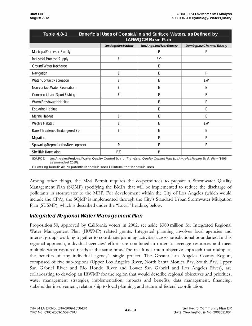
Regional Water Quality Control Plan Los Angeles Region (Basin Plan) The Water Quality Control Plan Los Angeles Region Basin Plan (Basin Plan) identifies beneficial uses for surface water bodies adjoining the CPA. Table 4.8-1 (Beneficial Uses of Coastal/Inland Surface Waters, as Defined by LARWQCB Basin Plan) lists these uses.
The Basin Plan also establishes the following beneficial uses for groundwater resources that underlie the CPA: municipal and domestic supply, industrial service supply, industrial process supply, and agricultural supply.
Los Angeles County Stormwater Quality Management Plan (SQMP) Discharges of urban runoff into municipally owned separate storm sewer systems (MS4s) are regulated under the general NPDES stormwater permit that has been issued by the RWQCB for Los Angeles County (“MS4 Permit”). Development that could occur under the proposed plan would be subject, as applicable, to the waste discharge requirements issued by the RWQCB for the MS4 Permit.
The City of Los Angeles is a co-permittee under the MS4 Permit, and therefore has joint/concurrent legal authority to enforce the terms of the permit within its jurisdiction, including the CPA. The MS4 Permit is intended to ensure that combinations of site planning, source control, and treatment control practices are implemented to protect the quality of receiving waters. The permit requires that new development employ best management practices (BMPs) designed to control pollutants in stormwater runoff to the maximum extent practicable (MEP), details specific sizing criteria for BMPs, and specifies flow control requirements. These BMPs include structural practices, source control and treatment techniques and systems, and site design planning principles addressing water quality.
105 Los Angeles Regional Water Quality Control Board, The Water Quality Control Plan Los Angeles Region Basin Plan (1995, amended 2010).
4.8-13
CHAPTER 4 Environmental Analysis SECTION 4.8 Hydrology/Water Quality
San Pedro Community Plan EIR State Clearinghouse No. 2008021004
City of LA EIR No. ENV-2009-1558-EIR CPC No. CPC-2009-1557-CPU
Draft EIR August 2012
Table 4.8-1 Beneficial Uses of Coastal/Inland Surface Waters, as Defined by LARWQCB Basin Plan
Los Angeles Harbor Los Angeles River Estuary Dominguez Channel Estuary
Municipal/Domestic Supply P P
Industrial Process Supply E E/P
Ground Water Recharge E
Navigation E E P
Water Contact Recreation E E E/P
Non-contact Water Recreation E E E
Commercial and Sport Fishing E E E
Warm Freshwater Habitat E P
Estuarine Habitat E E
Marine Habitat E E E
Wildlife Habitat E E E/P
Rare Threatened Endangered Sp. E E E
Migration E E
Spawning/Reproduction/Development P E E
Shellfish Harvesting P/E P SOURCE: Los Angeles Regional Water Quality Control Board, The Water Quality Control Plan Los Angeles Region Basin Plan (1995,
as amended 2010). E = existing beneficial; P = potential beneficial uses; I = intermittent beneficial uses
Among other things, the MS4 Permit requires the co-permittees to prepare a Stormwater Quality Management Plan (SQMP) specifying the BMPs that will be implemented to reduce the discharge of pollutants in stormwater to the MEP. For development within the City of Los Angeles (which would include the CPA), the SQMP is implemented through the City’s Standard Urban Stormwater Mitigation Plan (SUSMP), which is described under the “Local” heading, below.
Integrated Regional Water Management Plan Proposition 50, approved by California voters in 2002, set aside $380 million for Integrated Regional Water Management Plan (IRWMP) related grants. Integrated planning involves local agencies and interest groups working together to coordinate planning activities across jurisdictional boundaries. In this regional approach, individual agencies’ efforts are combined in order to leverage resources and meet multiple water resource needs at the same time. The result is a multi-objective approach that multiplies the benefits of any individual agency’s single project. The Greater Los Angeles County Region, comprised of five sub-regions (Upper Los Angeles River, North Santa Monica Bay, South Bay, Upper San Gabriel River and Rio Hondo River and Lower San Gabriel and Los Angeles River), are collaborating to develop an IRWMP for the region that would describe regional objectives and priorities, water management strategies, implementation, impacts and benefits, data management, financing, stakeholder involvement, relationship to local planning, and state and federal coordination.
4.8-14
CHAPTER 4 Environmental Analysis SECTION 4.8 Hydrology/Water Quality
San Pedro Community Plan EIR State Clearinghouse No. 2008021004
City of LA EIR No. ENV-2009-1558-EIR CPC No. CPC-2009-1557-CPU
Draft EIR August 2012
A critical component of the planning effort is identifying projects that would help achieve the goals and objectives of the IRWMP. The Greater Los Angeles County Region, through the Los Angeles County department of Public Works, has identified an extensive list of projects that are seeking funding through the IRWMP process. There are no established policies or standards that would apply to the proposed plan, and the proposed plan would not require implementation of those projects, but IRWMP projects may benefit the CPA by enhancing water quality and flood protection efforts. Those projects could include catch basin screens and inserts and Los Angeles River trash TMDL (full capture BMPs), Dominguez Gap spreading grounds (West Basin percolation enhancement), and lower Los Angeles River flood control.106
Flood Protection
Flood protection in the region is managed by three agencies: (1) the USACE oversees construction of projects associated with navigable bodies of water, including the Los Angeles River-related flood control systems and ocean harbors; (2) the Los Angeles County Department of Public Works (LADPW oversees construction of ancillary LA County Flood Control District (LACFCD) facilities and designs and/or maintains the flood control drainage facilities, including the Los Angeles River system (under the guidance of the USACE) to reduce the impacts of 100- and 500-year storms; and (3) the City of Los Angeles Bureau of Engineering oversees construction and maintenance of the City’s storm drainage system, which is designed to reduce the impacts of 50-year magnitude storms. Various City agencies implement development permit, slope stability, and watershed protection regulations.
Local City of Los Angeles General Plan Policies related to hazards and disasters are found in the Safety Element of the City’s General Plan. Policies related to the protection and restoration of oceans and fisheries are found in the Conservation Element. Polices related to groundwater recharge, runoff, and pollution are found in the General Plan Framework (GPF).
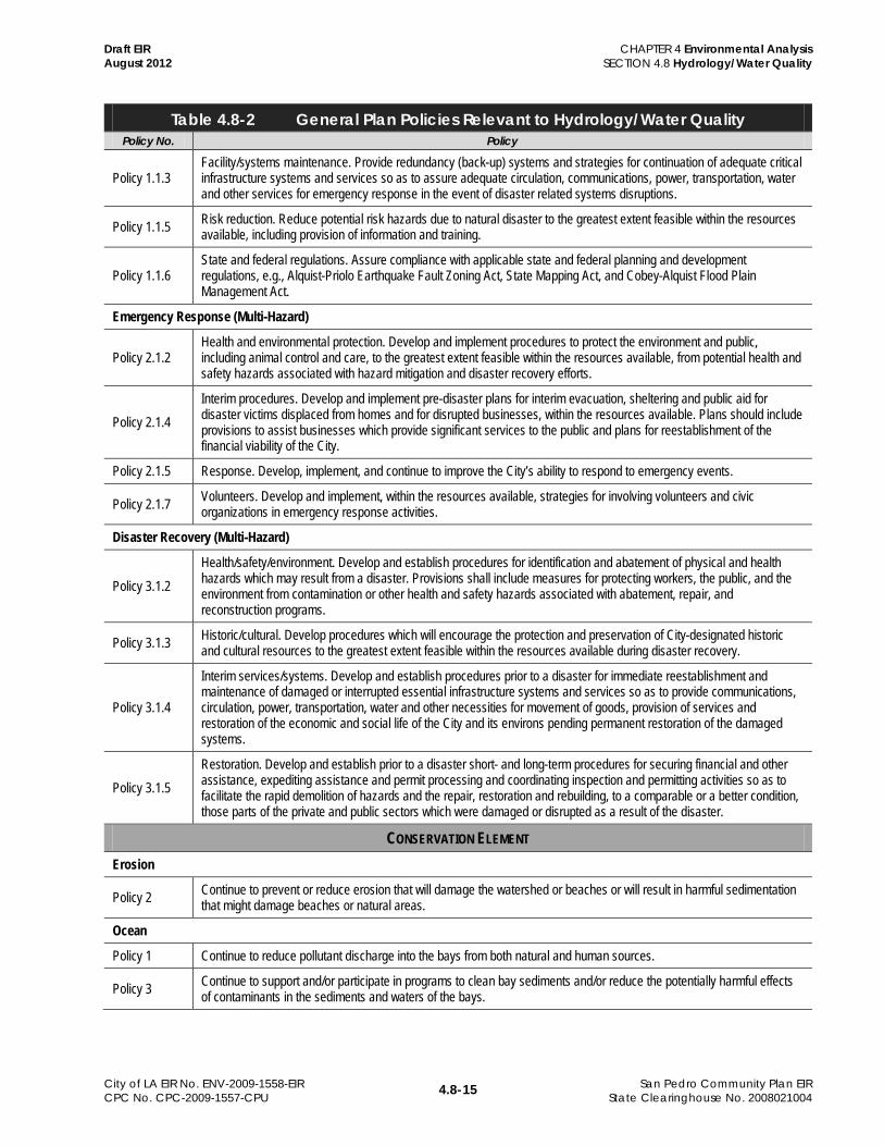
Policies from the Safety and Conservation Elements and the GPF related to hydrology/water quality are listed in Table 4.8-2 (General Plan Policies Relevant to Hydrology/Water Quality).
Table 4.8-2 General Plan Policies Relevant to Hydrology/Water Quality Policy No. Policy
SAFETY ELEMENT Hazard Mitigation
Policy 1.1.2 Disruption reduction. Reduce, to the greatest extent feasible and within the resources available, potential critical facility, governmental functions, infrastructure and information resource disruption due to natural disaster.
106 Leadership Committee of the Greater Los Angeles County Integrated Regional Water Management, Greater Los Angeles County Regions Integrated Regional Water Management Plan (December 13, 2006), http://www.ladpw.org/wmd/irwmp/.
4.8-15
CHAPTER 4 Environmental Analysis SECTION 4.8 Hydrology/Water Quality
San Pedro Community Plan EIR State Clearinghouse No. 2008021004
City of LA EIR No. ENV-2009-1558-EIR CPC No. CPC-2009-1557-CPU
Draft EIR August 2012
Table 4.8-2 General Plan Policies Relevant to Hydrology/Water Quality Policy No. Policy
Policy 1.1.3 Facility/systems maintenance. Provide redundancy (back-up) systems and strategies for continuation of adequate critical infrastructure systems and services so as to assure adequate circulation, communications, power, transportation, water and other services for emergency response in the event of disaster related systems disruptions.
Policy 1.1.5 Risk reduction. Reduce potential risk hazards due to natural disaster to the greatest extent feasible within the resources available, including provision of information and training.
Policy 1.1.6 State and federal regulations. Assure compliance with applicable state and federal planning and development regulations, e.g., Alquist-Priolo Earthquake Fault Zoning Act, State Mapping Act, and Cobey-Alquist Flood Plain Management Act.
Emergency Response (Multi-Hazard)
Policy 2.1.2 Health and environmental protection. Develop and implement procedures to protect the environment and public, including animal control and care, to the greatest extent feasible within the resources available, from potential health and safety hazards associated with hazard mitigation and disaster recovery efforts.
Policy 2.1.4 Interim procedures. Develop and implement pre-disaster plans for interim evacuation, sheltering and public aid for disaster victims displaced from homes and for disrupted businesses, within the resources available. Plans should include provisions to assist businesses which provide significant services to the public and plans for reestablishment of the financial viability of the City.
Policy 2.1.5 Response. Develop, implement, and continue to improve the City’s ability to respond to emergency events.
Policy 2.1.7 Volunteers. Develop and implement, within the resources available, strategies for involving volunteers and civic organizations in emergency response activities.
Disaster Recovery (Multi-Hazard)
Policy 3.1.2 Health/safety/environment. Develop and establish procedures for identification and abatement of physical and health hazards which may result from a disaster. Provisions shall include measures for protecting workers, the public, and the environment from contamination or other health and safety hazards associated with abatement, repair, and reconstruction programs.
Policy 3.1.3 Historic/cultural. Develop procedures which will encourage the protection and preservation of City-designated historic and cultural resources to the greatest extent feasible within the resources available during disaster recovery.
Policy 3.1.4
Interim services/systems. Develop and establish procedures prior to a disaster for immediate reestablishment and maintenance of damaged or interrupted essential infrastructure systems and services so as to provide communications, circulation, power, transportation, water and other necessities for movement of goods, provision of services and restoration of the economic and social life of the City and its environs pending permanent restoration of the damaged systems.
Policy 3.1.5 Restoration. Develop and establish prior to a disaster short- and long-term procedures for securing financial and other assistance, expediting assistance and permit processing and coordinating inspection and permitting activities so as to facilitate the rapid demolition of hazards and the repair, restoration and rebuilding, to a comparable or a better condition, those parts of the private and public sectors which were damaged or disrupted as a result of the disaster.
CONSERVATION ELEMENT Erosion
Policy 2 Continue to prevent or reduce erosion that will damage the watershed or beaches or will result in harmful sedimentation that might damage beaches or natural areas.
Ocean
Policy 1 Continue to reduce pollutant discharge into the bays from both natural and human sources.
Policy 3 Continue to support and/or participate in programs to clean bay sediments and/or reduce the potentially harmful effects of contaminants in the sediments and waters of the bays.
4.8-16
CHAPTER 4 Environmental Analysis SECTION 4.8 Hydrology/Water Quality
San Pedro Community Plan EIR State Clearinghouse No. 2008021004
City of LA EIR No. ENV-2009-1558-EIR CPC No. CPC-2009-1557-CPU
Draft EIR August 2012
Table 4.8-2 General Plan Policies Relevant to Hydrology/Water Quality Policy No. Policy
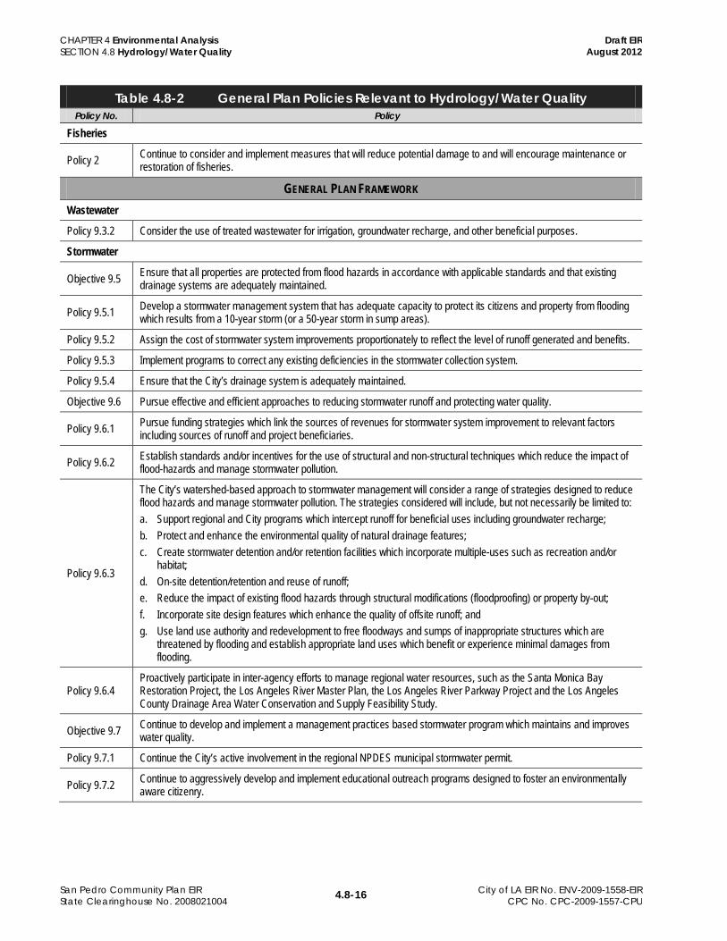
Fisheries
Policy 2 Continue to consider and implement measures that will reduce potential damage to and will encourage maintenance or restoration of fisheries.
GENERAL PLAN FRAMEWORK Wastewater
Policy 9.3.2 Consider the use of treated wastewater for irrigation, groundwater recharge, and other beneficial purposes.
Stormwater
Objective 9.5 Ensure that all properties are protected from flood hazards in accordance with applicable standards and that existing drainage systems are adequately maintained.
Policy 9.5.1 Develop a stormwater management system that has adequate capacity to protect its citizens and property from flooding which results from a 10-year storm (or a 50-year storm in sump areas).
Policy 9.5.2 Assign the cost of stormwater system improvements proportionately to reflect the level of runoff generated and benefits.
Policy 9.5.3 Implement programs to correct any existing deficiencies in the stormwater collection system.
Policy 9.5.4 Ensure that the City’s drainage system is adequately maintained.
Objective 9.6 Pursue effective and efficient approaches to reducing stormwater runoff and protecting water quality.
Policy 9.6.1 Pursue funding strategies which link the sources of revenues for stormwater system improvement to relevant factors including sources of runoff and project beneficiaries.
Policy 9.6.2 Establish standards and/or incentives for the use of structural and non-structural techniques which reduce the impact of flood-hazards and manage stormwater pollution.
Policy 9.6.3
The City’s watershed-based approach to stormwater management will consider a range of strategies designed to reduce flood hazards and manage stormwater pollution. The strategies considered will include, but not necessarily be limited to: a. Support regional and City programs which intercept runoff for beneficial uses including groundwater recharge; b. Protect and enhance the environmental quality of natural drainage features; c. Create stormwater detention and/or retention facilities which incorporate multiple-uses such as recreation and/or
habitat; d. On-site detention/retention and reuse of runoff; e. Reduce the impact of existing flood hazards through structural modifications (floodproofing) or property by-out; f. Incorporate site design features which enhance the quality of offsite runoff; and g. Use land use authority and redevelopment to free floodways and sumps of inappropriate structures which are
threatened by flooding and establish appropriate land uses which benefit or experience minimal damages from flooding.
Policy 9.6.4 Proactively participate in inter-agency efforts to manage regional water resources, such as the Santa Monica Bay Restoration Project, the Los Angeles River Master Plan, the Los Angeles River Parkway Project and the Los Angeles County Drainage Area Water Conservation and Supply Feasibility Study.
Objective 9.7 Continue to develop and implement a management practices based stormwater program which maintains and improves water quality.
Policy 9.7.1 Continue the City’s active involvement in the regional NPDES municipal stormwater permit.
Policy 9.7.2 Continue to aggressively develop and implement educational outreach programs designed to foster an environmentally aware citizenry.
4.8-17
CHAPTER 4 Environmental Analysis SECTION 4.8 Hydrology/Water Quality
San Pedro Community Plan EIR State Clearinghouse No. 2008021004
City of LA EIR No. ENV-2009-1558-EIR CPC No. CPC-2009-1557-CPU
Draft EIR August 2012
Table 4.8-2 General Plan Policies Relevant to Hydrology/Water Quality Policy No. Policy
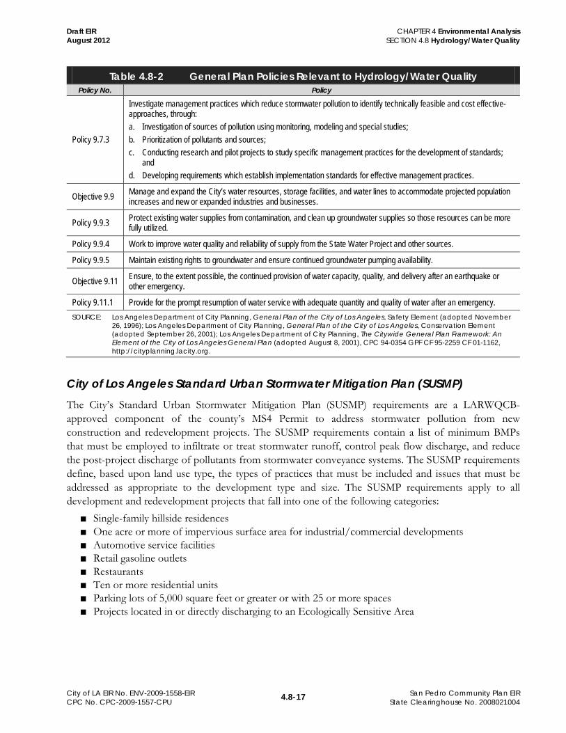
Policy 9.7.3
Investigate management practices which reduce stormwater pollution to identify technically feasible and cost effective-approaches, through: a. Investigation of sources of pollution using monitoring, modeling and special studies; b. Prioritization of pollutants and sources; c. Conducting research and pilot projects to study specific management practices for the development of standards;
and d. Developing requirements which establish implementation standards for effective management practices.
Objective 9.9 Manage and expand the City’s water resources, storage facilities, and water lines to accommodate projected population increases and new or expanded industries and businesses.
Policy 9.9.3 Protect existing water supplies from contamination, and clean up groundwater supplies so those resources can be more fully utilized.
Policy 9.9.4 Work to improve water quality and reliability of supply from the State Water Project and other sources.
Policy 9.9.5 Maintain existing rights to groundwater and ensure continued groundwater pumping availability.
Objective 9.11 Ensure, to the extent possible, the continued provision of water capacity, quality, and delivery after an earthquake or other emergency.
Policy 9.11.1 Provide for the prompt resumption of water service with adequate quantity and quality of water after an emergency. SOURCE: Los Angeles Department of City Planning, General Plan of the City of Los Angeles, Safety Element (adopted November
26, 1996); Los Angeles Department of City Planning, General Plan of the City of Los Angeles, Conservation Element (adopted September 26, 2001); Los Angeles Department of City Planning, The Citywide General Plan Framework: An Element of the City of Los Angeles General Plan (adopted August 8, 2001), CPC 94-0354 GPF CF 95-2259 CF 01-1162, http://cityplanning.lacity.org.
City of Los Angeles Standard Urban Stormwater Mitigation Plan (SUSMP) The City’s Standard Urban Stormwater Mitigation Plan (SUSMP) requirements are a LARWQCB-approved component of the county’s MS4 Permit to address stormwater pollution from new construction and redevelopment projects. The SUSMP requirements contain a list of minimum BMPs that must be employed to infiltrate or treat stormwater runoff, control peak flow discharge, and reduce the post-project discharge of pollutants from stormwater conveyance systems. The SUSMP requirements define, based upon land use type, the types of practices that must be included and issues that must be addressed as appropriate to the development type and size. The SUSMP requirements apply to all development and redevelopment projects that fall into one of the following categories:
■ Single-family hillside residences ■ One acre or more of impervious surface area for industrial/commercial developments ■ Automotive service facilities ■ Retail gasoline outlets ■ Restaurants ■ Ten or more residential units ■ Parking lots of 5,000 square feet or greater or with 25 or more spaces ■ Projects located in or directly discharging to an Ecologically Sensitive Area
4.8-18
CHAPTER 4 Environmental Analysis SECTION 4.8 Hydrology/Water Quality
San Pedro Community Plan EIR State Clearinghouse No. 2008021004
City of LA EIR No. ENV-2009-1558-EIR CPC No. CPC-2009-1557-CPU
Draft EIR August 2012
City of Los Angeles Municipal Code Section 17.05(M) of the Los Angeles Municipal Code (LAMC) prescribes performance standards for storm drain systems. Storm drains must be designed in conformance with standards approved by the City Engineer. Storm drain facilities that intercept and convey all runoff to a suitable point of disposal are required when runoff exceeds the limiting depth of street flow as determined by the City Engineer. Storm drains must be of sufficient capacity in all cases to prevent flooding of building sites from a storm of a 50-year frequency.
LAMC Chapter 64.72 lists the City’s requirements for stormwater and urban runoff pollution control. Provisions include prohibitions of illicit discharges, illicit connections, and spills, dumping and disposals to the MS4; pollutant control requirements from sites of industrial activities; and requirements for construction activity stormwater measures. The Los Angeles Municipal Code also promulgates requirements for stormwater BMPs, which include the following:
■ For parking lots with more than 25 spaces, BMPs must be implemented to reduce the discharge of pollutants to the MEP.
■ For other premises exposed to stormwater, BMPs, if they exist, or other steps shall be used to reduce the discharge of pollutants to the MEP. This includes the removal and lawful disposal from all parts of the premises exposed to stormwater of any solid waste or any other substance, which if discharged to the MS4, would be a pollutant.
Floodplain Development The City of Los Angeles has an ordinance governing permit review and mitigation procedures for issuance of development permits in areas prone to flooding, mudflow, or coastal inundation. The City’s Specific Plan for the Management of Flood Hazards (Specific Plan) was originally established by Ordinance No. 154,405, and amended most recently in July 1998 by Ordinance No. 172,081. The Ordinance No. 172,081 designates the City Engineer as the Flood Hazard Mitigation Coordinator for the City. The “Flood Hazard Management Specific Plan” (also referred to as the City of LA Floodplain Management Program) also specifies the responsibilities of City agencies that process the permits to ensure consistency with applicable FEMA requirements for NFIP coverage. Mitigation measures include relocation of structures within a property, increased base elevation, additional structural reinforcement, anchoring, and installation of protective barriers. A permit can be denied if mitigation is deemed insufficient to protect human life.
City of Los Angeles Local Hazard Mitigation Plan (LHMP) The City approved its Local Hazard Mitigation Plan in 2005. The plan identifies potential natural and human-caused hazards, and potential scenarios and estimated losses, addresses existing and proposed mitigation policies, programs and projects, and response programs.107
107 City of Los Angeles, City of Los Angeles Hazard Mitigation Plan (2005), Executive Summary.
4.8-19
CHAPTER 4 Environmental Analysis SECTION 4.8 Hydrology/Water Quality
San Pedro Community Plan EIR State Clearinghouse No. 2008021004
City of LA EIR No. ENV-2009-1558-EIR CPC No. CPC-2009-1557-CPU
Draft EIR August 2012
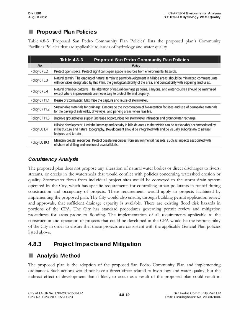
Proposed Plan Policies Table 4.8-3 (Proposed San Pedro Community Plan Policies) lists the proposed plan’s Community Facilities Policies that are applicable to issues of hydrology and water quality.
Table 4.8-3 Proposed San Pedro Community Plan Policies No. Policy
Policy CF6.2 Protect open space. Protect significant open space resources from environmental hazards.
Policy CF6.3 Natural terrain. The grading of natural terrain to permit development in hillside areas should be minimized commensurate with densities designated by this Plan, the geological stability of the area, and compatibility with adjoining land uses.
Policy CF6.4 Natural drainage patterns. The alteration of natural drainage patterns, canyons, and water courses should be minimized except where improvements are necessary to protect life and property.
Policy CF11.1 Reuse of stormwater. Maximize the capture and reuse of stormwater.
Policy CF11.2 Sustainable materials for drainage. Encourage the incorporation of bio-retention facilities and use of permeable materials for the paving of sidewalks, driveways, and parking areas when feasible.
Policy CF11.3 Improve groundwater supply. Increase opportunities for stormwater infiltration and groundwater recharge.
Policy LU1.4 Hillside development. Limit the intensity and density in hillside areas to that which can be reasonably accommodated by infrastructure and natural topography. Development should be integrated with and be visually subordinate to natural features and terrain.
Policy LU19.1 Maintain coastal resources. Protect coastal resources from environmental hazards, such as impacts associated with offshore oil drilling and erosion of coastal bluffs.
Consistency Analysis The proposed plan does not propose any alteration of natural water bodies or direct discharges to rivers, streams, or creeks in the watersheds that would conflict with policies concerning watershed erosion or quality. Stormwater flows from individual project sites would be conveyed to the storm drain system operated by the City, which has specific requirements for controlling urban pollutants in runoff during construction and occupancy of projects. These requirements would apply to projects facilitated by implementing the proposed plan. The City would also ensure, through building permit application review and approvals, that sufficient drainage capacity is available. There are existing flood risk hazards in portions of the CPA. The City has standard procedures governing permit review and mitigation procedures for areas prone to flooding. The implementation of all requirements applicable to the construction and operation of projects that could be developed in the CPA would be the responsibility of the City in order to ensure that those projects are consistent with the applicable General Plan policies listed above.
4.8.3 Project Impacts and Mitigation
Analytic Method The proposed plan is the adoption of the proposed San Pedro Community Plan and implementing ordinances. Such actions would not have a direct effect related to hydrology and water quality, but the indirect effect of development that is likely to occur as a result of the proposed plan could result in
4.8-20
CHAPTER 4 Environmental Analysis SECTION 4.8 Hydrology/Water Quality
San Pedro Community Plan EIR State Clearinghouse No. 2008021004
City of LA EIR No. ENV-2009-1558-EIR CPC No. CPC-2009-1557-CPU
Draft EIR August 2012
hydrologic effects such as changes in stormwater flows and quality and potential exposure of people and structures to flood hazards. Baseline information for the analysis was compiled from a review of data and reports published by state agencies, environmental documents for projects in the vicinity, as well as information compiled and evaluated by the City of Los Angeles in conjunction with its stormwater management and hazard mitigation programs. The result of that effort is a general and qualitative analysis of the types of hydrologic and water quality changes that could be expected relative to the proposed types and locations of land use changes and related zoning.
Independent of the CEQA process, there is a comprehensive regulatory framework implemented at the state and City level to reduce the impacts of effects related to storm drainage, urban pollutants, and flood hazards. Compliance with these regulations is required, not optional. Compliance must be demonstrated by the project proponent to have been incorporated in the plan’s design before permits for project construction would be issued. The analysis presented herein assumes compliance with all applicable laws, regulations, and standards.
The Los Angeles CEQA Thresholds Guide (2006) sets forth guidance for the determination of significance of hydrology and water quality impacts. This guidance is based on CEQA Guidelines Appendix G and provides specific criteria to be considered when making a significance determination. For purposes of this analysis, Thresholds Guide criteria are used, supplemented by the thresholds identified in Appendix G, where appropriate.
Thresholds of Significance The following thresholds of significance are based on Appendix G of the 2011 CEQA Guidelines. For purposes of this EIR, implementation of the proposed plan may have a significant adverse impact on hazards and hazardous materials if it would:
■ Substantially reduce or increase the amount of surface water in a water body ■ Result in a permanent, adverse change to the movement of surface water sufficient to produce a
substantial change in the current or direction of water flow in a manner that would result in flooding on or off site
■ Cause flooding during the projected 50-year developed storm event which would have the potential to harm people or damage property or sensitive biological resources
■ Create or contribute runoff water that would exceed the capacity of existing or planned stormwater drainage systems or provide substantial additional sources of polluted runoff
■ Place housing within a 100-year flood hazard area as mapped on a federal Flood Hazard Boundary or Flood Insurance Rate Map or other flood hazard delineation map, or place within a 100-year flood hazard area structures that would impede or redirect flood flows
■ Expose people or structures to a significant risk of loss, injury or death involving flooding, including flooding as a result of the failure of a levee or dam, or sea level rise
■ Expose people or structures to inundation by seiche, tsunami, or mudflow ■ Create pollution, contamination, or nuisance as defined in Section 13050 of the California Water
Code or cause regulatory standards to be violated, as defined in the applicable National Pollution Discharge Elimination System storm water permit or Water Quality Control Plan for the receiving water body
4.8-21
CHAPTER 4 Environmental Analysis SECTION 4.8 Hydrology/Water Quality
San Pedro Community Plan EIR State Clearinghouse No. 2008021004
City of LA EIR No. ENV-2009-1558-EIR CPC No. CPC-2009-1557-CPU
Draft EIR August 2012
■ Substantially alter the existing drainage pattern of the site or area, including through the alteration of the course of a stream or river, in a manner that would result in substantial erosion or siltation on or off site
Effects Not Found to Be Significant The proposed plan is not in an area subject to flooding from failure of a levee or dam. There would be no impact.
Less-Than-Significant Impacts Impacts associated with the thresholds are grouped by the following topics: drainage and flooding and water quality.
Drainage and Flooding Impact 4.8-1 Implementation of the proposed plan would minimally change stormwater
flows and volumes but would not contribute to off-site flooding potential or changes in the amount of surface water or surface water flow direction or current. This impact is less than significant.
The proposed plan and implementing ordinances primarily consist of General Plan Amendments to create consistency with GPF Land Use designations, create consistency between existing land uses on parcels or with existing surrounding uses, restrict incompatible uses, and correct minor errors. The proposed plan and implementing ordinances could indirectly result in the construction of some new development on vacant or undeveloped land. However, this new development would not result in adverse stormwater and flooding effects because only less than 1 percent of the land in the CPA is vacant or undeveloped. Development would be limited to smaller, infill-type projects that would not substantially increase impervious surfaces or alter drainage patterns in a manner that would increase peak flow or volume of stormwater discharged to existing systems.
The City of Los Angeles requires that all storm drainage improvements in new hillside developments be designed to accommodate a 50-year storm event. In addition, the proposed plan includes Policies CF11.1, CF11.2, and CF11.3 that encourage the use of infiltration system technology, bio-retention, and stormwater capture, while discouraging projects that would alter drainage patterns (Policy CF6.4 and Policy LU1.4).
With implementation of the existing City of Los Angeles standards, the proposed plan and implementing ordinances would not lead to increased flooding by altering existing drainage patterns or cause flooding during a projected 50-year storm event that would have the potential to harm people or damage property or sensitive biological resources. Therefore, impacts related to flooding and water flow are less than significant, and no mitigation measures are required.
4.8-22
CHAPTER 4 Environmental Analysis SECTION 4.8 Hydrology/Water Quality
San Pedro Community Plan EIR State Clearinghouse No. 2008021004
City of LA EIR No. ENV-2009-1558-EIR CPC No. CPC-2009-1557-CPU
Draft EIR August 2012
Impact 4.8-2 Implementation of the proposed plan would not expose people or structures to 100-year flood hazard or place structures in locations that could impede or redirect flood flows. This impact is less than significant.
As shown on Figure 4.8-2, there are FEMA-designated 100-year flood hazards zones along the coastal cliffs in the southern portion of the CPA, including Point Fermin Park near the Los Angeles Harbor breakwater, and two small areas in the CPA (one between Pacific Avenue and Gaffey Street south of 3rd Street, and the other east of Walker Avenue and north of 13th Street). There is one FEMA-designated 500-year flood hazard zone within the CPA at Point Fermin Park near the Los Angeles Harbor breakwater. These flood hazard areas have been mapped by FEMA and development within these flood hazard areas is restricted.
None of the proposed plan changes would permit new development within these flood zones. Implementation of the existing City of Los Angeles policies and regulatory requirements would ensure the adoption and implementation of the proposed plan would not place housing or structures within a flood hazard zone or in an area that would impede or redirect flood flows. Therefore, these impacts are less than significant, and no mitigation measures are required.
Impact 4.8-3 Small portions of the CPA could be exposed to inundation by tsunami, but little or no development in those locations is planned, and existing hazard mitigation programs that address emergency notification and evacuation would ensure that this impact remains less than significant.
Some areas along the coastal cliffs in the southern portion of the CPA are susceptible to tsunami, and a small area in the southeast area may be susceptible as well. However, the proposed plan and implementing ordinances do not propose any changes to this area, and the land uses would remain open space. Further, proposed plan Policy 6.2 encourages the protection of significant open space resources from environmental hazards. As previously discussed in Section 4.5 (Geology/Soils and Mineral Resources), the adoption and implementation of the proposed plan, in combination with the City’s standard grading and building permit requirements, would not expose people or structures to potential substantial risk due to seiche, tsunami, or mudflow. Therefore, these impacts are less than significant, and no mitigation measures are required.
Water Quality Impact 4.8-4 Implementation of the proposed plan would minimally contribute
additional stormwater runoff containing urban pollutants to local water bodies, but would not result in violation of regulatory standards. This impact is less than significant.
Surface Water Quality
The CPA does not contain surface water resources that receive stormwater flows from the proposed plan, but water from storm drainage facilities in the CPA could potentially become contaminated with urban pollutants (e.g., roof and parking lot runoff, pesticides and fertilizers, and sediment) in stormwater runoff generated by development in the CPA. The addition of pollutants from locations that drain to the
4.8-23
CHAPTER 4 Environmental Analysis SECTION 4.8 Hydrology/Water Quality
San Pedro Community Plan EIR State Clearinghouse No. 2008021004
City of LA EIR No. ENV-2009-1558-EIR CPC No. CPC-2009-1557-CPU
Draft EIR August 2012
City’s storm drain system could contribute polluted runoff to the Los Angeles/Long Beach Harbor, thereby affecting water quality, if water quality controls are not implemented.
The proposed plan and implementing ordinances propose some changes in the area of the East Basin and along the Los Angeles Harbor. The area along North Gaffey Street closest to the East Basin would be redesignated from Heavy Industrial to Light Industrial. Some increases in density are proposed in the sub-areas in the Downtown near the East Basin or Los Angeles Harbor, but no new land use types are proposed. None of the changes or amendments would introduce land uses near the East Basin or Los Angeles Harbor (see Figure 4.8-2) that would create polluted runoff that would directly degrade water quality in the Harbor. As such, these changes would not result in substantial new polluting land uses.
The proposed plan would otherwise provide for development as described in the 1999 San Pedro Community Plan. This could increase the number of occupied structures in the CPA that could, in turn, increase the number of people or structures that could be exposed to liquefaction and geologic hazards. The City of Los Angeles has comprehensive standard requirements for development to ensure that violations of water quality standards do not occur. For example, the City enforces its SUSMP, a comprehensive stormwater quality program to manage urban stormwater and minimize pollution of the environment to the maximum extent practicable. The goals and objectives of the SUSMP are achieved through the use of BMPs that attempt to manage runoff water quality. Site design or planning management BMPs are used to minimize runoff from new development and to discourage development in environmentally sensitive areas that are critical to maintaining water quality. Source control BMPs are usually the most effective and economical in preventing pollutants from entering storm and non-storm runoff. Treatment Control (or structural) BMPs involve physical treatment of the runoff, usually through structural means.
The SUSMP identifies the types and size of private development projects that are subject to these requirements. Required elements of the SUSMP include provisions for:
■ Peak stormwater runoff discharge rates (post-development peak stormwater runoff discharge rates shall not exceed the estimated pre-development rate for developments where the increased peak stormwater discharge rate will result in increased potential for downstream erosion)
■ Conservation of natural areas ■ Minimization of stormwater pollutants of concern ■ Protection of slopes and channels ■ Storm drain system stenciling and signage ■ Properly designed outdoor material storage areas ■ Properly designed trash storage areas ■ Proof of ongoing BMP Maintenance ■ Design standards for structural or treatment control BMPs ■ Provisions for individual priority project categories ■ Limitations on use of infiltration BMPs
Requirements of the SUSMP are enforced through the City’s plan approval and permit process and all new development projects are subject to City inspection. Furthermore, all applicable projects must
4.8-24
CHAPTER 4 Environmental Analysis SECTION 4.8 Hydrology/Water Quality
San Pedro Community Plan EIR State Clearinghouse No. 2008021004
City of LA EIR No. ENV-2009-1558-EIR CPC No. CPC-2009-1557-CPU
Draft EIR August 2012
comply with Article 4.4 of LAMC, Section 64.72, which governs pollutant control requirements and construction activity requirements. Compliance with the LAMC would ensure that construction does not violate any water quality standards or discharge requirements or otherwise substantially degrade water quality. In addition, implementation of proposed plan Policies CF 11.1, CF 11.2, and CF 11.3 that encourage the use of infiltration system technology, bio-retention, and stormwater capture, which would be reviewed during project design, would comprise effective stormwater quality BMPs. Impacts are less than significant, and no mitigation is required.
Groundwater
Implementation of the proposed plan would not involve direct groundwater withdrawal or injection. Existing seawater intrusion features would not be affected, nor would any known contaminant plumes. Recharge potential is negligible. The stormwater quality BMPs described above would effectively manage surface water quality so that stormwater infiltration, if any, would not represent a substantial risk to groundwater quality degradation. Therefore, impacts with respect to violations of water quality standards, discharge, and rate or movement of existing contaminants are less than significant, and no mitigation is required.
Impact 4.8-5 Implementation of the proposed plan would cause negligible changes in surface drainage patterns and surface water bodies in a manner that could cause erosion or siltation. This impact is less than significant.
The proposed plan and implementing ordinances primarily consist of General Plan Amendments to create consistency with GPF Land Use designations, create consistency between existing land uses on parcels or with existing surrounding uses, restrict incompatible uses, and correct minor errors. The proposed plan and implementing ordinances could result in an increase in development in the CPA, requiring grading activities on individual parcels during development. However, as explained in Impact 4.8-1, there is very little vacant land (approximately 0.05 percent) in the CPA, and future development occurring under the proposed plan would occur on vacant parcels or as infill scattered throughout the CPA. The proposed plan does not propose large developments that would result in the type of land alteration that would result in substantial changes in drainage patterns that would affect erosion potential (see also Impact 4.5-5 in Section 4.5).
As explained, all new development projects are subject to the SUSMP and City inspection. Furthermore, all applicable projects must comply with Article 4.4 of LAMC, Section 64.72, which governs pollutant control requirements and construction activity requirements. Compliance with the SUSMP and LAMC Section 64.72 would ensure that erosion or siltation is minimized.
The proposed plan includes policies that would directly help minimize erosion potential by limiting development in locations (e.g., hillsides and coastline) where water quality could be affected by soil disturbance. These include Policies CF6.3, CF6.4, and CF6.5 and Policies LU1.4 and LU19.2. The proposed plan would also incorporate the City’s proposed Baseline Hill Ordinance requirements that, among other controls, would include proposed grading regulations. The proposed regulations establish a new limit that uses a base quantity of grading plus a percentage of the lot size, with a maximum value that would be based on the property’s zoning. It would also limit the amount of export/import. An
4.8-25
CHAPTER 4 Environmental Analysis SECTION 4.8 Hydrology/Water Quality
San Pedro Community Plan EIR State Clearinghouse No. 2008021004
City of LA EIR No. ENV-2009-1558-EIR CPC No. CPC-2009-1557-CPU
Draft EIR August 2012
indirect outcome of the Hillside Ordinance is that it could help reduce soil erosion potential in hillside areas, where erosional effects would be most likely to occur.
With implementation of the SUSMP, LAMC, and proposed plan policies, the adoption and implementation of the proposed plan and implementing ordinances would not substantially alter the existing drainage pattern of the site or area resulting in erosion/siltation or result in a permanent, adverse change to the movement of surface water sufficient to produce a substantial change in the current or direction of water flow. Therefore, impacts related to erosion/siltation are less than significant, and no mitigation is required.
Significant and Unavoidable Impacts Impact 4.8-6 A small shoreline segment of the CPA, east of Pacific Avenue and
extending south to Point Fermin, could be exposed to flooding from future sea level rise, partially from incremental effects from the growth anticipated by the CPA. Implementation of feasible mitigation measure MM4.8-1 would reduce this impact, but not to less than significant. Therefore, this impact is significant and unavoidable.
Maps prepared by the Pacific Institute show expected flood inundation areas associated with a 1.4-meter (55-inch) sea level rise for San Pedro and adjoining communities for year 2100 (refer to Appendix E of this EIR). As illustrated, the majority of potential inundation areas border Los Angeles Harbor and the coastline, either outside the CPA boundary or in areas that would remain open space (e.g., coastline). However, there is a small segment in the southeast portion of the CPA, east of Pacific Avenue and extending east to Point Fermin that scientists predict could be exposed to higher water levels than under existing conditions as a result of sea level rise.
The proposed plan and implementing ordinances primarily consist of General Plan Amendments to create consistency with GPF Land Use designations, create consistency between existing land uses on parcels or with existing surrounding uses, and restrict incompatible uses. As explained in Impact 4.6-1 in Section 4.6 (Greenhouse Gas Emissions), implementation of the proposed plan could directly contribute greenhouse gas emissions that could have an impact on climate change, of which sea level rise is one of many potential outcomes. However, sea levels are predicted to rise regardless of whether the proposed plan is implemented, and CEQA in general does not require analysis of the environment’s effect on the project. Nonetheless, this analysis conservatively assumes that to the extent the proposed plan would facilitate or accommodate future development, especially along the areas in close proximity to the coastline, the resulting growth would incrementally increase emissions that could have some level of impact on sea level rise and would increase the number of people and structures that could be exposed to flood risk associated with sea level rise. This would be an indirect effect of the proposed plan.
Higher sea levels could cause backing-up of the storm drain system, increasing the chance of runoff-induced flooding. Additionally, sea level rise would have a commensurate increase in shallow groundwater levels that could indirectly affect belowground structures and 50-year flood hazard areas. While the CPA’s incremental contribution is likely small, it is difficult to assess. To be conservative and to account for the areas in close proximity to the coastline that are part of the CPA, these indirect effects
4.8-26
CHAPTER 4 Environmental Analysis SECTION 4.8 Hydrology/Water Quality
San Pedro Community Plan EIR State Clearinghouse No. 2008021004
City of LA EIR No. ENV-2009-1558-EIR CPC No. CPC-2009-1557-CPU
Draft EIR August 2012
would be considered significant because sea level rise could expose people or structures to loss, injury, or death from flooding.
Implementation of mitigation measure MM4.8-1 would help reduce this impact by ensuring development in locations subject to sea level rise are adequately protected to withstand hydrostatic forces and buoyancy effects. Sea level rise is of primary importance in San Pedro because it could cause flooding in areas not currently subject to flood hazard. Project-specific environmental analysis of discretionary projects in the CPA will still be required and would result in identification of applicable and feasible mitigation of project impacts. The program level environmental clearance for the proposed Community Plan does not eliminate future environmental review for any discretionary specific project level development. Because any future development project is considered on a case-by-case basis and the proposed CPA and its objectives do not create absolute prohibitions on development that may incrementally impact sea level rise, a level of uncertainty remains and therefore this impact would be considered significant and unavoidable.
Mitigation Measures The proposed plan includes policies and programs that would reduce any potential hydrology and water quality impacts. In addition, the City of Los Angeles provides additional environmental review for discretionary development on a project-by-project basis. The following mitigation measures shall be implemented for development under the proposed plan:
MM4.8-1 Provide Flood Protection up to the 50-Year Flood plus Sea Level Rise. To protect structures and people from sea level rise risks, prior to approving discretionary grading and/or building permits in areas that could be exposed to sea-level rise, the City shall ensure project design incorporates its floodplain development requirements for a flood depth of the identified 50-year flood hazard water surface elevation plus a 4.6-foot (55-inch) rise in sea level for those locations that could be directly affected. All aboveground structures within predicted sea-level-rise inundation areas shall be flood proofed and able to withstand hydrostatic forces and buoyancy to this elevation. All enclosed, belowground structures in predicted sea-level-rise inundation areas shall be flood proofed in their entirety and designed to withstand hydrostatic forces and buoyancy from water surface elevations up to 4.6 feet above ground surface.
Level of Significance After Mitigation With implementation of the described mitigation and conditions of approval, impacts on hydrology and water quality, except for sea level rise, would be reduced to less than significant. To the extent the proposed plan would facilitate or accommodate future development, the resulting growth would increase the number of people and structures that could be exposed to flood risk associated with sea level rise. Impacts would be reduced, but not to less than significant. Therefore, impacts relative to sea level rise would be significant and unavoidable.
Project-level mitigation measures will be developed and implemented through discretionary project review and impositions of conditions. The mitigation measure identified here does not replace or preclude the implementation of the city’s zoning code, building code, and life safety code, nor does it replace project-level environmental review for future discretionary projects.
4.8-27
CHAPTER 4 Environmental Analysis SECTION 4.8 Hydrology/Water Quality
San Pedro Community Plan EIR State Clearinghouse No. 2008021004
City of LA EIR No. ENV-2009-1558-EIR CPC No. CPC-2009-1557-CPU
Draft EIR August 2012
4.8.4 Cumulative Impacts The analysis of hydrology/water quality impacts resulting from the adoption and implementation of the proposed plan considers the effects of future growth and development throughout the geographic extent of the CPA. The cumulative context for the analysis of hydrology and water quality impacts is a function of the type of impact and geographic considerations. Some cumulative impacts may have a broad, regional context, while others may be limited by site-specific conditions or location. The cumulative context regarding flooding and drainage and water quality is described at the beginning of each analysis, below.
Drainage and Flooding The cumulative context for storm drainage impacts is the extensive storm drain system operated by the City of Los Angeles, which is described in the Environmental Setting in this section. There are no natural surface water drainages that would directly receive storm flows from the proposed plan. Stormwater flows from the CPA currently combine with those from surrounding development in the greater Los Angeles area and are discharged into the storm drain system. Section 17.05(M) of the City’s Municipal Code prescribes performance standards for storm drain systems, which would apply to cumulative development contributing flows to the system. The proposed plan is almost entirely built out with impervious surfaces, and flows from those areas are already accounted for in system capacity. Potential projects that could be implemented under the proposed plan would not result in substantial increases in impervious surfaces due to the type of project (square feet or massing). Therefore, the rate and volume of stormwater flows from the CPA would represent a negligible contribution to system flows and potential cumulative effects on capacity. The proposed plan’s contribution would not be cumulatively considerable, and cumulative impacts related to drainage and potential indirect effects on localized flooding are less than significant.
The cumulative context for flood hazards is the corporate boundary of City of Los Angeles, which participates in the NFIP and provides emergency response services for flood events. Within the city, 100-year and 500-year flood hazard zones generally correspond to natural river, stream, and/or creek channels. There are only a few small areas designated Zone A (100-year event) in the CPA. One is along coastal cliffs and two areas that are already built out. Flood hazard would exist regardless of whether the proposed plan is implemented. Rehabilitation, renovation, and/or new construction could change building footprints and result in changes in the number of people who could be exposed to flood hazard. In addition, because of the increasing threat from sea level rise, the area of Zone A is expected to increase over time. Like other locations throughout Los Angeles that could be exposed to 100-year flood risk or risks from sea level rise, projects would be required to comply with the City’s Floodplain Management requirements, and insurance would be available to affected property owners under the NFIP. However, with the introduction of additional urban development, a level of uncertainty remains, and, therefore, cumulative impacts relative to sea level rise are significant and unavoidable.
Water Quality The cumulative context for water quality is existing and reasonably foreseeable development in the Los Dominguez Channel watershed. The subwatershed (Los Angeles/Long Beach Harbors) that receives
4.8-28
CHAPTER 4 Environmental Analysis SECTION 4.8 Hydrology/Water Quality
San Pedro Community Plan EIR State Clearinghouse No. 2008021004
City of LA EIR No. ENV-2009-1558-EIR CPC No. CPC-2009-1557-CPU
Draft EIR August 2012
storm flows from the CPA has water quality impairments (pollutants or stressors) as determined by the LARWQCB, resulting in the need for bacteria, nutrients, metals, toxics, and trash TMDLs, as indicated in the Environmental Setting in this section. With respect to construction, all development within the Dominguez Channel watershed is required to conform to applicable WDRs. Cumulative development projects in incorporated cities and unincorporated areas would be required to implement construction BMPs, as would projects facilitated by adoption and implementation of the proposed plan. Both the City of Los Angeles and Los Angeles County are required to impose these requirements. Stormwater runoff from cumulative development in the watershed, including development that could be facilitated by the proposed plan, could contribute to water quality impairments if measures are not implemented to minimize pollutant levels in runoff.
As required by the SUSMP, all foreseeable development projects, including projects that could be constructed in the CPA (as applicable) would be required to implement operational BMPs to control release of pollutants in stormwater runoff. Requirements of the SUSMP are enforced through the City’s plan approval and permit process, and all new development projects are subject to City inspection. Furthermore, all applicable projects must comply with Article 4.4 of LAMC, Section 64.72, which governs pollutant control requirements and construction activity requirements. Redevelopment typically would be limited to small infill projects, the nature of which would not significantly change the types or amounts of pollutants in stormwater runoff. Therefore, the plan’s contribution to known water quality impairments would not be cumulatively considerable, and cumulative water quality impacts are less than significant.
4.8.5 References California Climate Change Center. Climate Change Scenarios and Sea Level Rise Estimates for the California 2009
Climate Change Scenarios Assessment. CEC-500-2009-014-F. Prepared by Dan Cayan, Mary Tyree, Mike Dettinger, Hugo Hidalgo, Tapash Das, Ed Maurer, Peter Bromirski, Nicholas Graham, and Reinhard Flick, August 2009.
———. Projecting Future Sea Level. CEC-500-2005-202-SF. Prepared by D. Cayan, P. Bromirski, K. Hayhoe, M. Tyree, M. Dettinger, and R. Flick, March 2006.
———. The Impacts of Sea Level Rise on the California Coast. CEC-500-2009-024-F. Prepared by Matthew Heberger, Heather Cooley, Pablo Herrera, Peter H. Gleick, and Eli Moore of the Pacific Institute, August 2009.
California Department of Water Resources. California’s Groundwater. Bulletin 118, 2004. Heberger, Matthew, and Pablo Herrera. California coast 100-year flood with a 1.4-meter sea-level rise,
2100: The Impacts of Sea-Level Rise on the California Coast, Pacific Institute, Oakland CA, 2009. http://www.pacinst.org/reports/sea_level_rise/maps/. Figures for 55-inch sea level rise inundation: http://www.pacinst.org/reports/sea_level_rise/hazmaps/San_Pedro.pdf, http://www.pacinst.org/reports/sea_level_rise/hazmaps/Torrance.pdf, http://www.pacinst.org/reports/sea_level_rise/hazmaps/Long_Beach.pdf.
Leadership Committee of the Greater Los Angeles County Integrated Regional Water Management. Greater Los Angeles County Regions Integrated Regional Water Management Plan, December 13, 2006. http://www.ladpw.org/wmd/irwmp/.
Los Angeles Department of City Planning. City of Los Angeles Hazard Mitigation Plan, 2005. ———. General Plan of the City of Los Angeles. Conservation Element, adopted September 26, 2001.

4.8-29
CHAPTER 4 Environmental Analysis SECTION 4.8 Hydrology/Water Quality
San Pedro Community Plan EIR State Clearinghouse No. 2008021004
City of LA EIR No. ENV-2009-1558-EIR CPC No. CPC-2009-1557-CPU
Draft EIR August 2012
———. General Plan of the City of Los Angeles. Safety Element, adopted November 26, 1996. ———. San Pedro New Community Plan, 2011. ———. The Citywide General Plan Framework: An Element of the City of Los Angeles General Plan. CPC 94-
0354 GPF CF 95-2259 CF 01-1162, adopted August 8, 2001. http://cityplanning.lacity.org. Los Angeles Department of Public Works, Bureau of Sanitation. About the Los Angeles Storm Drain
System. http://www.lastormwater.org/Siteorg/general/lastrmdrn.htm. Los Angeles Department of Public Works, Bureau of Sanitation, Watershed Protection Division. Water
Quality Compliance Master Plan for Urban Runoff, May 2009. Los Angeles Harbor Department. San Pedro Waterfront Project Draft EIS/EIR, 2008. Los Angeles Police Department. Tsunami San Pedro Area Evacuation Maps, January 2008. Los Angeles Regional Water Quality Control Board. The Water Quality Control Plan Los Angeles Region Basin
Plan, 1995, amended 2010.
