5. uc santa cruz long-range development plan …lrdp).pdfuc santa cruz has consistently articulated...
TRANSCRIPT
UC SANTA CRUZ LONG-RANGE DEVELOPMENT PLAN 2005–2020
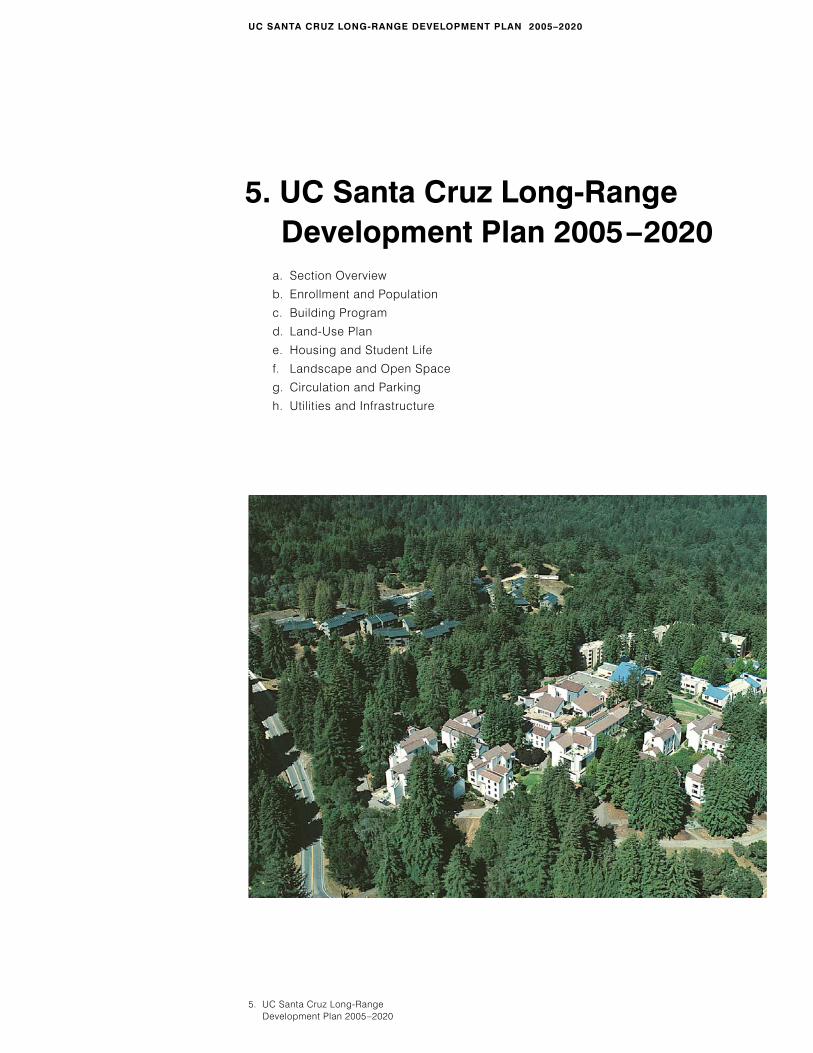
5. UC Santa Cruz Long-Range Development Plan 2005–2020
a. Section Overview
b. Enrollment and Population
c. Building Program
d. Land-Use Plan
e. Housing and Student Life
f. Landscape and Open Space
g. Circulation and Parking
h. Utilities and Infrastructure
5. UC Santa Cruz Long-Range Development Plan 2005–2020
a. Section Overview5. UC Santa Cruz Long-Range Development Plan 2005–2020
57
UC SANTA CRUZ LONG-RANGE DEVELOPMENT PLAN 2005–2020
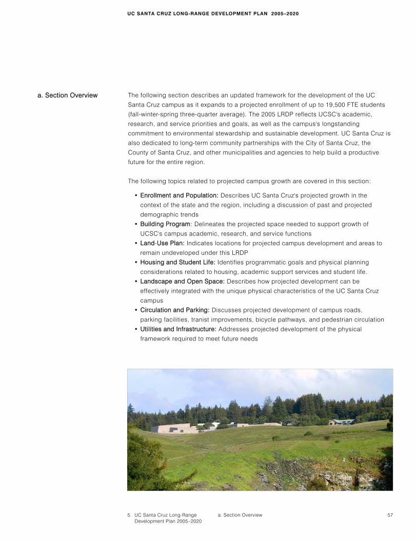
The following section describes an updated framework for the development of the UC
Santa Cruz campus as it expands to a projected enrollment of up to 19,500 FTE students
(fall-winter-spring three-quarter average). The 2005 LRDP reflects UCSC's academic,
research, and service priorities and goals, as well as the campus's longstanding
commitment to environmental stewardship and sustainable development. UC Santa Cruz is
also dedicated to long-term community partnerships with the City of Santa Cruz, the
County of Santa Cruz, and other municipalities and agencies to help build a productive
future for the entire region.
The following topics related to projected campus growth are covered in this section:
• Enrollment and Population: Describes UC Santa Cruz's projected growth in the
context of the state and the region, including a discussion of past and projected
demographic trends
• Building Program: Delineates the projected space needed to support growth of
UCSC's campus academic, research, and service functions
• Land-UUse Plan: Indicates locations for projected campus development and areas to
remain undeveloped under this LRDP
• Housing and Student Life: Identifies programmatic goals and physical planning
considerations related to housing, academic support services and student life.
• Landscape and Open Space: Describes how projected development can be
effectively integrated with the unique physical characteristics of the UC Santa Cruz
campus
• Circulation and Parking: Discusses projected development of campus roads,
parking facilities, tranist improvements, bicycle pathways, and pedestrian circulation
• Utilities and Infrastructure: Addresses projected development of the physical
framework required to meet future needs
aa.. SSeeccttiioonn OOvveerrvviieeww

18. Approximately 300 students were enrolled in off-campus programs.
b. Enrollment and Population
58 September 2006
The 2005 LRDP accommodates an increase in student enrollment on campus to a fall-
winter-spring three-quarter average of 19,500 FTE by the year 2020 (of which graduate and
professional enrollments are anticipated to comprise 15 percent). This number reflects an
average of the total number of FTE students enrolled at UC Santa Cruz during the fall,
winter, and spring quarters of the academic year (FWS 3-quarter average). This enrollment
projection includes only those students enrolled in programs on the main campus, and
excludes students who attend in the summer and attend programs at off-site locations.
Total enrollment was approximately 14,400 in 2003-04.18 Growth to 19,500 students would
represent an increase of approximately 5,100 students over 2003-04 total enrollment.
Additional faculty and staff will be hired to accommodate the growth in students and
research.
DERIVATION OF THE ENROLLMENT PROJECTIONS
UC Santa Cruz has consistently articulated a campus vision that encompasses a breadth
and depth of undergraduate academic programs, a fully developed range of graduate
programs, appropriate professional programs, and a vibrant research enterprise. In
addition, UCSC has a regional role as the UC campus serving Santa Cruz, Monterey and
Santa Clara counties. Each of these elements results in drivers for future UCSC enrollment.
The growth projections articulated in this LRDP were derived after careful consideration by
the Strategic Futures Committee (SFC) of both internal programmatic aspirations and
external drivers.
Although demand for a UC education would be consistent with a higher enrollment level,
the campus has selected to base its 2005 LRDP on a fall-winter-spring 3-quarter average
enrollment of up to 19,500 on-campus FTE students–representing a growth rate which it
believes it can accommodate.
ACADEMIC PROGRAMS AS A DRIVER
A primary factor in assessing future growth is ensuring UCSC's role as a comprehensive
public research university within the University of California system. This requires continued
evolution and expansion of existing programs, maturation of others, and implementation of
new areas of inquiry. An assessment of potential academic programs was developed after
careful consideration of recently concluded 10-year divisional plans, new and existing
program development, and faculty input.
STATE DEMOGRAPHICS AND ENROLLMENT DEMANDS
Enrollment pressures on the UC system are driven by a combination of factors including
the number of high school graduates, their eligibility, participation rate (percent of eligible

b. Enrollment and Population5. UC Santa Cruz Long-Range Development Plan 2005–2020
59
students who elect to attend a UC campus), transfer enrollments, and demand for graduate
and professional education (both by students and employers). Consistent with its intent to
honor the state Master Plan for Higher Education, the UC system is committed to accepting
students from the top 12.5 percent of California's high school class as well as accommo-
dating the top four percent of each high school. Each UC campus shares in this
responsibility and seeks to accommodate an appropriate proportion of those students who
meet the university's eligibility requirements.
GROWTH IN SUMMER ENROLLMENT
UC Santa Cruz plans to grow its summer programs in order to accommodate increased
student demand and to provide opportunities to develop specialized programs. Currently,
students enrolled in the summer term are drawn primarily from the campus fall-winter-
spring population. Summer enrollments do create additional faculty workload and generate
additional faculty positions.
Summer student population for 2020 is estimated at about 1,500 to 1,750 student FTE
(about 6,700 to 7,850 individual students) spread out over multiple sessions throughout the
summer.
GROWTH IN STAFF AND FACULTY
The number of faculty is projected to increase by about 360, in a direct relationship to the
increase in enrollment. On-campus staff growth (which includes researchers and non-
teaching academic positions) is expected to increase by roughly 980.
UC SANTA CRUZ LONG-RANGE DEVELOPMENT PLAN 2005–2020
UCSC STUDENTS UCSC FACULTY AND STAFF TOTAL ON-CAMPUS POPULATION
2003–04
Projected Growth
to 2020–21
30,000
25,000
20,000
15,000
10,000
5,000
0
TTAABBLLEE 22UUCCSSCC OONN-CCAAMMPPUUSS SSTTUUDDEENNTT AANNDDEEMMPPLLOOYYEEEE GGRROOWWTTHH
Academic,Support andHousing
Existing and Approved Space
Additional Space
ASF GSF ASF GSF
3,113,000 4,825,000 5,235,000 8,000,000
EstimatedTotal
ASF GSF
60 September 2006
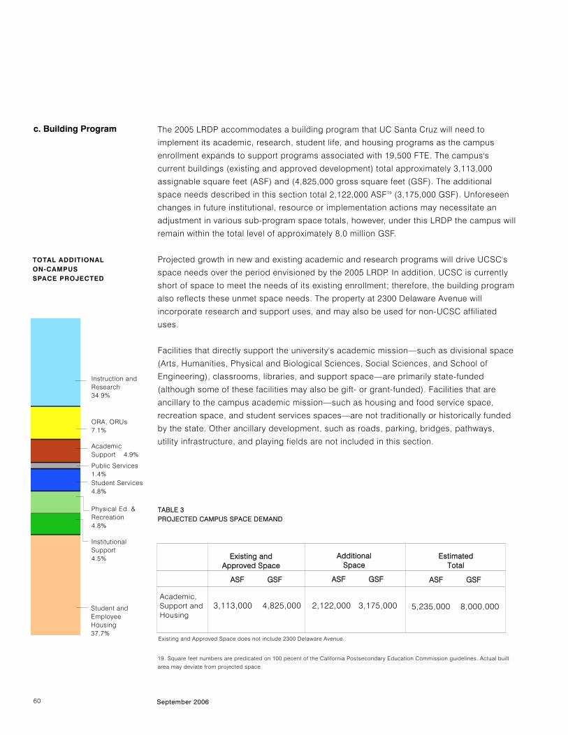
The 2005 LRDP accommodates a building program that UC Santa Cruz will need to
implement its academic, research, student life, and housing programs as the campus
enrollment expands to support programs associated with 19,500 FTE. The campus's
current buildings (existing and approved development) total approximately 3,113,000
assignable square feet (ASF) and (4,825,000 gross square feet (GSF). The additional
space needs described in this section total 2,122,000 ASF19 (3,175,000 GSF). Unforeseen
changes in future institutional, resource or implementation actions may necessitate an
adjustment in various sub-program space totals, however, under this LRDP the campus will
remain within the total level of approximately 8.0 million GSF.
Projected growth in new and existing academic and research programs will drive UCSC's
space needs over the period envisioned by the 2005 LRDP. In addition, UCSC is currently
short of space to meet the needs of its existing enrollment; therefore, the building program
also reflects these unmet space needs. The property at 2300 Delaware Avenue will
incorporate research and support uses, and may also be used for non-UCSC affiliated
uses.
Facilities that directly support the university's academic mission—such as divisional space
(Arts, Humanities, Physical and Biological Sciences, Social Sciences, and School of
Engineering), classrooms, libraries, and support space—are primarily state-funded
(although some of these facilities may also be gift- or grant-funded). Facilities that are
ancillary to the campus academic mission—such as housing and food service space,
recreation space, and student services spaces—are not traditionally or historically funded
by the state. Other ancillary development, such as roads, parking, bridges, pathways,
utility infrastructure, and playing fields are not included in this section.
c. Building Program
19. Square feet numbers are predicated on 100 pecent of the California Postsecondary Education Commission guidelines. Actual built
area may deviate from projected space.
TTAABBLLEE 33PPRROOJJEECCTTEEDD CCAAMMPPUUSS SSPPAACCEE DDEEMMAANNDD
Instruction andResearch 34.9%
ORA, ORUs 7.1%
AcademicSupport 4.9%
Public Services1.4%Student Services4.8%
Student andEmployeeHousing37.7%
InstitutionalSupport 4.5%
Physical Ed. &Recreation 4.8%
TOTAL ADDITIONAL ON-CAMPUSSPACE PROJECTED
2,122,000 3,175,000
Existing and Approved Space does not include 2300 Delaware Avenue.
5. UC Santa Cruz Long-Range Development Plan 2005–2020
61
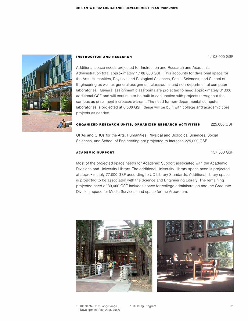
INSTRUCTION AND RESEARCH 1,108,000 GSF
Additional space needs projected for Instruction and Research and Academic
Administration total approximately 1,108,000 GSF. This accounts for divisional space for
the Arts, Humanities, Physical and Biological Sciences, Social Sciences, and School of
Engineering as well as general assignment classrooms and non-departmental computer
laboratories. General assignment classrooms are projected to need approximately 31,000
additional GSF and will continue to be built in conjunction with projects throughout the
campus as enrollment increases warrant. The need for non-departmental computer
laboratories is projected at 6,500 GSF; these will be built with college and academic core
projects as needed.
ORGANIZED RESEARCH UNITS, ORGANIZED RESEARCH ACTIVITIES 225,000 GSF
ORAs and ORUs for the Arts, Humanities, Physical and Biological Sciences, Social
Sciences, and School of Engineering are projected to increase 225,000 GSF.
ACADEMIC SUPPORT 157,000 GSF
Most of the projected space needs for Academic Support associated with the Academic
Divisions and University Library. The additional University Library space need is projected
at approximately 77,000 GSF according to UC Library Standards. Additional library space
is projected to be associated with the Science and Engineering Library. The remaining
projected need of 80,000 GSF includes space for college administration and the Graduate
Division, space for Media Services, and space for the Arboretum.
UC SANTA CRUZ LONG-RANGE DEVELOPMENT PLAN 2005–2020
c. Building Program

62 September 2006
PUBLIC SERVICES 43,000 GSF
The projected space need for Public Services totals approximately 43,000 additional GSF,
and includes facilities such as the Monterey Bay Nature/Orientation Center, a joint visitor
facility for the UCSC Arboretum and the Center for Agroecology and Sustainable Food
Systems and retail areas.
STUDENT SERVICES 151,000 GSF
Student Services will require approximately 151,000 additional GSF to meet existing
shortages of space and to provide for growth. Of this, about 132,000 GSF will be in non-
college facilities and 19,000 GSF will support new colleges. Included in the non-college
facilities are an addition to the Cowell Health Center, a new student union building, and
expansion of the Bay Tree Bookstore. Future college space will include student activity
facilities, coffee shops, and college counseling offices. Other future space may be
developed to further support UCSC’s rich and diverse history of cultural engagement.
These spaces may include resource and enrichment spaces for student voice and student
productions, student leadership, and student engagement.
PHYSICAL EDUCATION AND RECREATION 151,000 GSF
Physical Education and Recreation will need additional space of approximately 151,000
GSF. This includes an Events/Recreation Center and additional indoor recreation facilities.
5. UC Santa Cruz Long-Range Development Plan 2005–2020
63
INSTITUTIONAL SUPPORT 144,000 GSF
Projected space needs for Institutional Support total approximately 144,000 additional GSF,
including 37,000 GSF for campus administration and 107,000 GSF for general services.
The campus administration projection assumes that leased off-campus space will continue
to be available, or that some or all of the units leasing space would move to UCSC's
property on 2300 Delaware Avenue.
Included with the general services projects are future Environmental Health and Safety and
Child Care Facilities. Space for other units located throughout the campus will need
evaluation for the location of future buildings or reassignment of space.
STUDENT AND EMPLOYEE HOUSING 1,196,000 GSF
Given the unique characteristics of the colleges and the significance of housing as a whole
for the campus, the building program for housing is described in a separate section. The
residential college is one of UCSC’s most distinctive features, and under this LRDP the
residential college will remain a fundamental unit of campus growth.
UC SANTA CRUZ LONG-RANGE DEVELOPMENT PLAN 2005–2020
c. Building Program
Academic andSupport Space
Actual andApproved
HousingActual andApproved
ProjectedProjected
1
0
(Million)
2
3
4
5
6
7
8
9
TTAABBLLEE 44PPRROOJJEECCTTEEDD CCAAMMPPUUSS SSPPAACCEEDDEEMMAANNDD
Assignable Square Feet Gross Square Feet
64 September 2006
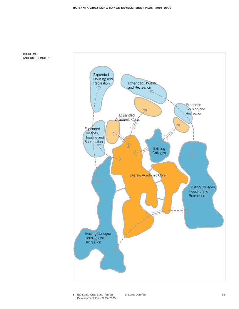
d. Land-Use Plan Similar to the 1963 founding plan for the campus and subsequent UCSC LRDPs, the 2005
LRDP Land-Use Plan identifies the need to extend development to the north to meet the
academic, research, and housing needs of the campus as it matures. The plan balances
development opportunity with conservation of natural resources and open space by
clustering new potential development areas and recognizing that additional density can be
added to existing developed areas. The Land-Use Concept plan, Figure 19, shows how the
academic core would expand north within the loop road, with an arc of colleges and
housing on the opposite side of a new loop road. Land between newly developed areas is
left in a natural state to break down the overall scale and provide habitat continuity. The
center of the expanded academic core, a generally sloping area known as the seep zone,
is reserved for natural resource education.
The Land-Use Plan, described below in text and in the land-use map, is based on the
Physical Planning Principles and Guidelines. It assigns elements of the building program to
designated land-use areas and describes general objectives that will guide development
within those areas. In some cases, building program elements may be assigned to more
than one land-use category in order to offer the campus opportunities to combine and
integrate program elements.
The boundaries of the land-use designations on the land-use plan are intended to provide
a general framework for campus uses and may be adjusted based on field conditions at
the time of implementation as long as the overall area for the given land-use remains the
same.
LAND-USE DESIGNATIONS
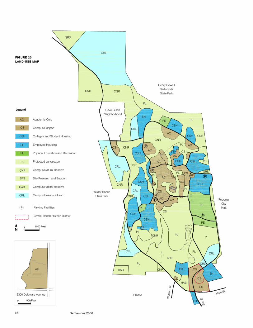
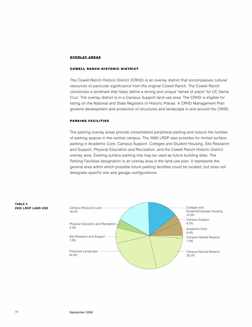
ACADEMIC CORE (AC)
The 2005 LRDP Academic Core encompasses approximately 132 acres. This will provide
space and flexibility for future expansion in the north campus for needs anticipated under
this plan, including potential professional schools and research functions. The boundary of
the Academic Core is defined by Heller Drive to the west, the Great Meadow to the south,
Hagar Drive to the east, and a new loop road to the north. Facilities to accommodate the
following building program elements will be the principal uses sited in the Academic Core:
Instruction and Research, Organized Research, Academic Support, Libraries, Student
Services, Public Services, and Institutional Support.
CAMPUS SUPPORT (CS)
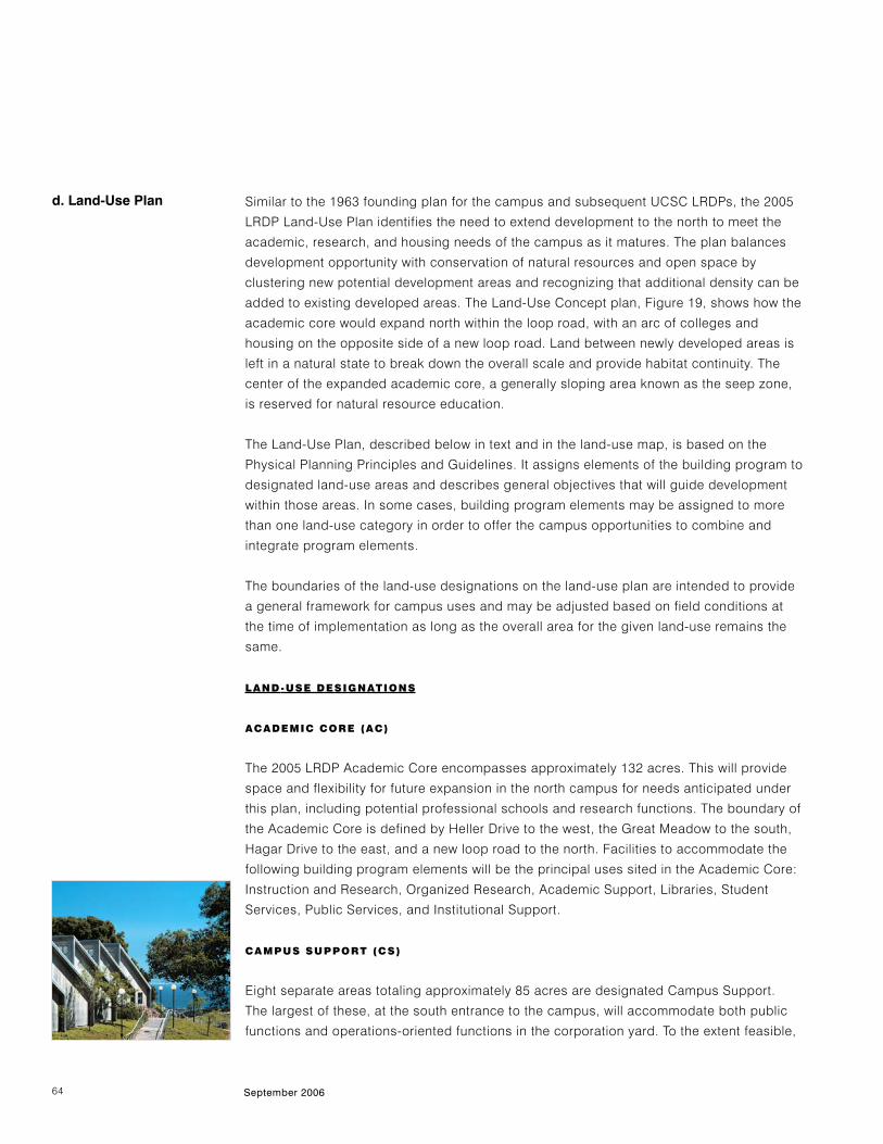
Eight separate areas totaling approximately 85 acres are designated Campus Support.
The largest of these, at the south entrance to the campus, will accommodate both public
functions and operations-oriented functions in the corporation yard. To the extent feasible,
5. UC Santa Cruz Long-Range Development Plan 2005–2020
65
FFIIGGUURREE 1199LLAANNDD-UUSSEE CCOONNCCEEPPTT
ExpandedHousing andRecreation
ExpandedColleges,Housing andReecreation
ExpandedAcademic Core
Expanded Housing and Recreation
Existing Academic Core
Existing Colleges, Housing and Recreation
ExpandedHousing andRecreation
Existing Colleges
Existing Colleges, Housing and Recreation
UC SANTA CRUZ LONG-RANGE DEVELOPMENT PLAN 2005–2020
d. Land-Use Plan
September 200666
FIGURE 20 LAND-USE MAP
SRS
CRL
CNR
PE
CSH
AC CS
SRS
PE
SRS
EH
CS
HAB
PL
CS
Wilder Ranch State Park
Cave GulchNeighborhood
PogonipCityPark
Wes
tern
Dr.
Bay
St.
Private
CNR
CNR
CNRCNR
CNR
CNR
Henry CowellRedwoods State Park
CNR
CNR
CRL
CRL
CRLCRL
PLPL
PL
PL
PL
PL
HAB
PE
EH
EH
CSH
CSH
AC
ACCS
CSAC
AC
AC
CS
CSH
CSH
CSH
PL
PLPL
CSH
CS
AC
High St.
CSH
AC
CS
Academic Core
Campus Support
Colleges and Student Housing
Employee Housing
Physical Education and Recreation
Protected Landscape
Campus Natural Reserve
Site Research and Support
Campus Habitat Reserve
Campus Resource Land
Legend
Parking Facilities
Cowell Ranch Historic District
AC
CS
CSH
EH
PE
PL
CNR
SRS
HAB
CRL
EH
N0 1000 Feet
2300 Delaware Avenue
AC
0 500 Feet
AC
PL
PE
AC
P
CS
CS
PL
PL
ACCNR
CRL
SRS
PL
CSH
CRL
CSH
CSH
CS
5. UC Santa Cruz Long-Range Development Plan 2005–2020
67
UC SANTA CRUZ LONG-RANGE DEVELOPMENT PLAN 2005–2020
d. Land-Use Plan
some facility and operational corporation yard functions will be relocated under this LRDP,
primarily to an 8-acre site off Empire Grade. This would allow improvements to the main
entrance area for public-oriented and visitor services and to improve efficiency in
operations.
The Quarry Plaza area north to McLaughlin Drive will expand to accommodate growth for
future Student Service functions, commercial and retail facilities and the Cowell Student
Health facility. The area housing the Fire Station will expand to meet projected future
needs. A new area is designated for Campus Support east of Earth and Marine Sciences
for infrastructure to support expansion of facilities and to supplement the Central Heating
and Cooling Plant (another Campus Support area). The area accommodating the University
House (the Chancellor's residence) will remain unchanged.
COLLEGES AND STUDENT HOUSING (CSH)
The college arc surrounding the academic core is designated Colleges and Student
Housing, and constitutes 228 acres in this LRDP. This area occupies land to the east, north,
and west of the academic core, and will accommodate the construction of new colleges,
expansion of existing colleges through infill, new undergraduate and graduate student
housing, and family student housing projects. In addition, housing-related parking and
recreational amenities will be provided in Colleges and Student Housing. Residential
facilities may include both residence hall, apartment style, and various suite-type
accommodations. (For additional information on college and housing program goals, see
section 5e. Housing and Student Life.)
The principal program elements permitted in Colleges and Student Housing include
Housing and Food Services, related recreational amenities, related parking, Student
Services, Academic Support, Family Student Housing, Childcare, and Physical Education
and Recreation. Some facilities for the academic divisions are located in the colleges; it is
also anticipated that new colleges will house some Instruction and Research space.
EMPLOYEE HOUSING (EH)
Approximately 69 acres encompassing existing development and undeveloped land are
designated as Employee Housing in this LRDP. Existing employee housing near the south
entrance, including Ranch View Terrace, occupies approximately 42 acres. A second 27-
acre area to the north has been designated for future development of employee housing.
Housing for faculty and staff, childcare facilities, and related accessory buildings are
consistent with this land use, together with associated parking and recreation space.
Additional employee housing could be located on Campus Resource Land.
68 September 2006
PHYSICAL EDUCATION AND RECREATION (PE)
Approximately 86 acres of relatively level land in three areas of the campus are designated
Physical Education and Recreation (PE) in this LRDP. Two of these areas, located east and
west of the Academic Core, already accommodate PE. The western area, approximately
four acres, does not have sufficient remaining undeveloped space for expansion of PE and
Recreation facilities. The east area, of approximately 71 acres, has adequate space for
additional indoor recreation facilities, playing fields, and courts. A third area of
approximately 14 acres to the north is currently undeveloped and could accommodate a
significant increase in indoor facilities, playing fields, courts, and other recreation facilities,
thereby providing a more balanced distribution of recreation opportunities across the
campus. This land-use designation can also accommodate parking and transit facilities. A
future recreation and events center could be located within this land use.
CAMPUS RESOURCE LAND (CRL)
The 1988 LRDP assigned approximately 471 acres of undeveloped land located in the
northern part of the campus to this land-use category. The 2005 LRDP land-use plan
designates 335 acres of undeveloped land, mainly located in the far north campus and
areas in the coastal zone west of Empire Grade and west of Porter College, to this land-use
category. This land-use designation is assigned to lands that are not planned for
development under the 2005 LRDP. It is envisioned that these lands would be maintained in
their natural state to serve as long-term reserve lands for future use. In the event that the
campus determines during the term of the 2005 LRDP that it needs to develop some
portion of this land, it will conduct additional environmental review and will seek an LRDP
amendment.
CAMPUS NATURAL RESERVE (CNR)
The land use designation “Enviromental Reserve” was established in 1988 LRDP in order to
protect certain of the campus’s natural features and processes for teaching and research.
The 1988 LRDP designated approximately 393 acres for this use. The proposed 2005 LRDP
renames this land use category Campus Natural Reserve (CNR) and designates 410 acres
for this use. Land under this designation would remain in its natural state except as
required for maintenance, as teaching and research reserve. Construction in this area is
prohibited, except as required in conjunction with teaching and research in the area, or the
limited construction of utilities, roads, and paths.
One section of the CNR, the Lower Moore Creek area adjacent to the Arboretum, will be
jointly managed under the direction of the UCSC Campus Natural Reserve and the
Arboretum and will include a California regional native plant garden, California red-legged
frog habitat improvements, and other support and interpretive structures.
5. UC Santa Cruz Long-Range Development Plan 2005–2020
69
SITE RESEARCH AND SUPPORT (SRS)
Three areas totaling approximately 154 acres are designated for Site Research and
Support in this LRDP. The first of these areas in the south campus includes land currently
used by the Center for Agroecology and Sustainable Food Systems (CASFS) and the UCSC
Arboretum. The second area in the far north includes 33 acres. The Chadwick Garden at
the east end of McLaughlin Drive, encompasses four acres. The development of new
buildings associated with these and future approved research programs is permitted within
these designated areas. The principal program elements associated with this land use are
Social Sciences, Physical and Biological Sciences, Student Services, and Public Services.
PROTECTED LANDSCAPE (PL)
The natural landscape of UC Santa Cruz has been recognized from the campus’s inception
as a unique asset that distinguishes UCSC from other universities. In addition to the 420
acres in the CNR, approximately 505 acres of land have been designated in this LRDP as
Protected Landscape in order to maintain special campus landscapes for their scenic
value and to maintain special vegetation and wildlife continuity zones. To the extent
feasible, Protected Landscape will be retained in an undeveloped state as the campus
grows. Any development within Protected Landscape will not impinge on its overall
character.
The meadows south of the developed center of the campus will be maintained as
undisturbed grassland. In these meadows, no building will be allowed. Agricultural
research that maintains the visual quality of the lower meadows may be allowed.
CAMPUS HABITAT RESERVE (HAB)
Two areas on campus, which total approximately 25.5 acres, are designated as Campus
Habitat Reserve (HAB). The larger of these two areas, a 13-acre parcel on the
southwestern corner of the campus adjacent to Wilder Creek, is designated as a reserve to
retain high-quality grassland and forest habitat on the campus for the California red-legged
frog and the Ohlone tiger beetle. This reserve was established pursuant to a 2005
Implementing Agreement between the U.S. Fish & Wildlife Service and The Regents. The
second area, a 12.5 acre parcel, is located in the southern portion of the campus near the
main entrance. A portion of the parcel is designated as a management site for Ohlone tiger
beetle habitat with the remainder of the site managed for California red-legged frog. HAB
lands are protected lands that will remain undeveloped except as permitted by the terms of
the Implementing Agreement and associated Habitat Conservation Plan (HCP).
UC SANTA CRUZ LONG-RANGE DEVELOPMENT PLAN 2005–2020
d. Land-Use Plan
Physical Education and Recreation4.2%
Campus Resource Land16.2%
Site Research and Support7.6%
Protected Landscape24.9%
Colleges andStudent/Employee Housing 14.3%
Campus Habitat Reserve1.3%
Campus Support4.2%
Academic Core6.5%
Campus Natural Reserve20.2%
70 September 2006
OVERLAY AREAS
COWELL RANCH HISTORIC DISTRICT
The Cowell Ranch Historic District (CRHD) is an overlay district that encompasses cultural
resources of particular significance from the original Cowell Ranch. The Cowell Ranch
constitutes a landmark that helps define a strong and unique "sense of place" for UC Santa
Cruz. The overlay district is in a Campus Support land-use area. The CRHD is eligible for
listing on the National and State Registers of Historic Places. A CRHD Management Plan
governs development and protection of structures and landscape in and around the CRHD.
PARKING FACILITIES
The parking overlay areas provide consolidated peripheral parking and reduce the number
of parking spaces in the central campus. The 2005 LRDP also provides for limited surface
parking in Academic Core, Campus Support, Colleges and Student Housing, Site Research
and Support, Physical Education and Recreation, and the Cowell Ranch Historic District
overlay area. Existing surface parking lots may be used as future building sites. The
Parking Facilities designation is an overlay area in the land-use plan. It represents the
general area within which possible future parking facilities could be located, but does not
designate specific site and garage configurations.
TABLE 52005 LRDP LAND USE
71
UC SANTA CRUZ LONG-RANGE DEVELOPMENT PLAN 2005–2020
5. UC Santa Cruz Long-RangeDevelopment Plan 2005–2020
71e. Housing and Student Life
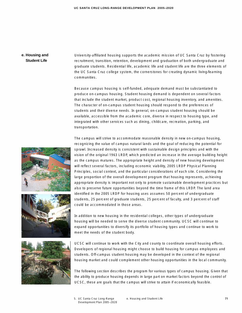
University-affiliated housing supports the academic mission of UC Santa Cruz by fostering
recruitment, transition, retention, development and graduation of both undergraduate and
graduate students. Residential life, academic life and student life are the three elements of
the UC Santa Cruz college system, the cornerstones for creating dynamic living/learning
communities.
Because campus housing is self-funded, adequate demand must be substantiated to
produce on-campus housing. Student housing demand is dependent on several factors
that include the student market, product cost, regional housing inventory, and amenities.
The character of on-campus student housing should respond to the preferences of
students and their diverse needs. In general, on-campus student housing should be
available, accessible from the academic core, diverse in respect to housing type, and
integrated with other services such as dining, childcare, recreation, parking, and
transportation.
The campus will strive to accommodate reasonable density in new on-campus housing,
recognizing the value of campus natural lands and the goal of reducing the potential for
sprawl. Increased density is consistent with sustainable design principles and with the
vision of the original 1963 LRDP, which predicted an increase in the average building height
as the campus matures. The appropriate height and density of new housing development
will reflect several factors, including economic viability, 2005 LRDP Physical Planning
Principles, social context, and the particular considerations of each site. Considering the
large proportion of the overall development program that housing represents, achieving
appropriate density is important not only to promote sustainable development practices but
also to preserve future opportunities beyond the time frame of this LRDP. The land area
identified in the 2005 LRDP for housing uses assumes 50 percent of undergraduate
students, 25 percent of graduate students, 25 percent of faculty, and 3 percent of staff
could be accommodated in those areas.
In addition to new housing in the residential colleges, other types of undergraduate
housing will be needed to serve the diverse student community. UCSC will continue to
expand opportunities to diversify its portfolio of housing types and continue to work to
meet the needs of the student body.
UCSC will continue to work with the City and county to coordinate overall housing efforts.
Developers of regional housing might choose to build housing for campus employees and
students. Off-campus student housing may be developed in the context of the regional
housing market and could complement other housing opportunities in the local community.
The following section describes the program for various types of campus housing. Given that
the ability to produce housing depends in large part on market factors beyond the control of
UCSC, these are goals that the campus will strive to attain if economically feasible.
e. Housing andStudent Life
72 September 2006
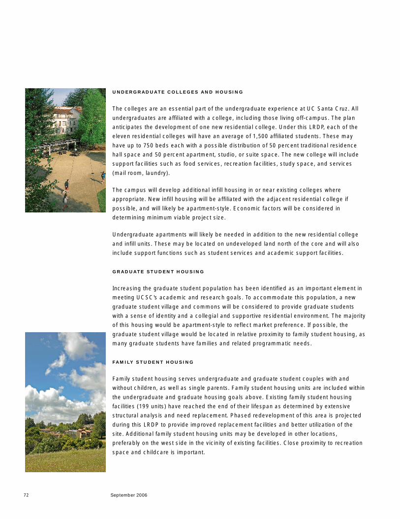
UNDERGRADUATE COLLEGES AND HOUSING
The colleges are an essential part of the undergraduate experience at UC Santa Cruz. All
undergraduates are affil iated with a college, including those living off-campus. The plan
anticipates the development of one new residential college. Under this LRDP, each of the
eleven residential colleges will have an average of 1,500 affiliated students. These may
have up to 750 beds each with a possible distribution of 50 percent traditional residence
hall space and 50 percent apartment, studio, or suite space. The new college will include
support facilities such as food services, recreation facilities, study space, and services
(mail room, laundry).
The campus will develop additional infill housing in or near existing colleges where
appropriate. New infil l housing will be affiliated with the adjacent residential college if
possible, and will likely be apartment-style. Economic factors will be considered in
determining minimum viable project size.
Undergraduate apartments will likely be needed in addition to the new residential college
and infil l units. These may be located on undeveloped land north of the core and will also
include support functions such as student services and academic support facil ities.
GRADUATE STUDENT HOUSING
Increasing the graduate student population has been identified as an important element in
meeting UCSC's academic and research goals. To accommodate this population, a new
graduate student village and commons will be considered to provide graduate students
with a sense of identity and a collegial and supportive residential environment. The majority
of this housing would be apartment-style to reflect market preference. If possible, the
graduate student village would be located in relative proximity to family student housing, as
many graduate students have families and related programmatic needs.
FAMILY STUDENT HOUSING
Family student housing serves undergraduate and graduate student couples with and
without children, as well as single parents. Family student housing units are included within
the undergraduate and graduate housing goals above. Existing family student housing
facilities (199 units) have reached the end of their lifespan as determined by extensive
structural analysis and need replacement. Phased redevelopment of this area is projected
during this LRDP to provide improved replacement facilities and better utilization of the
site. Additional family student housing units may be developed in other locations,
preferably on the west side in the vicinity of existing facil ities. Close proximity to recreation
space and childcare is important.
UC SANTA CRUZ LONG-RANGE DEVELOPMENT PLAN 2005–2020
5. UC Santa Cruz Long-RangeDevelopment Plan 2005–2020
e. Housing and Student Life
EMPLOYEE HOUSING
Providing housing opportunities for faculty and staff is an important element of the 2005
LRDP. Currently there are 325 units of existing housing including the approved Ranch View
Terrace project (84 units). On-campus employee housing should be accessible to campus
perimeter roads and also integrated with other services such recreation, childcare, parking,
and transportation.
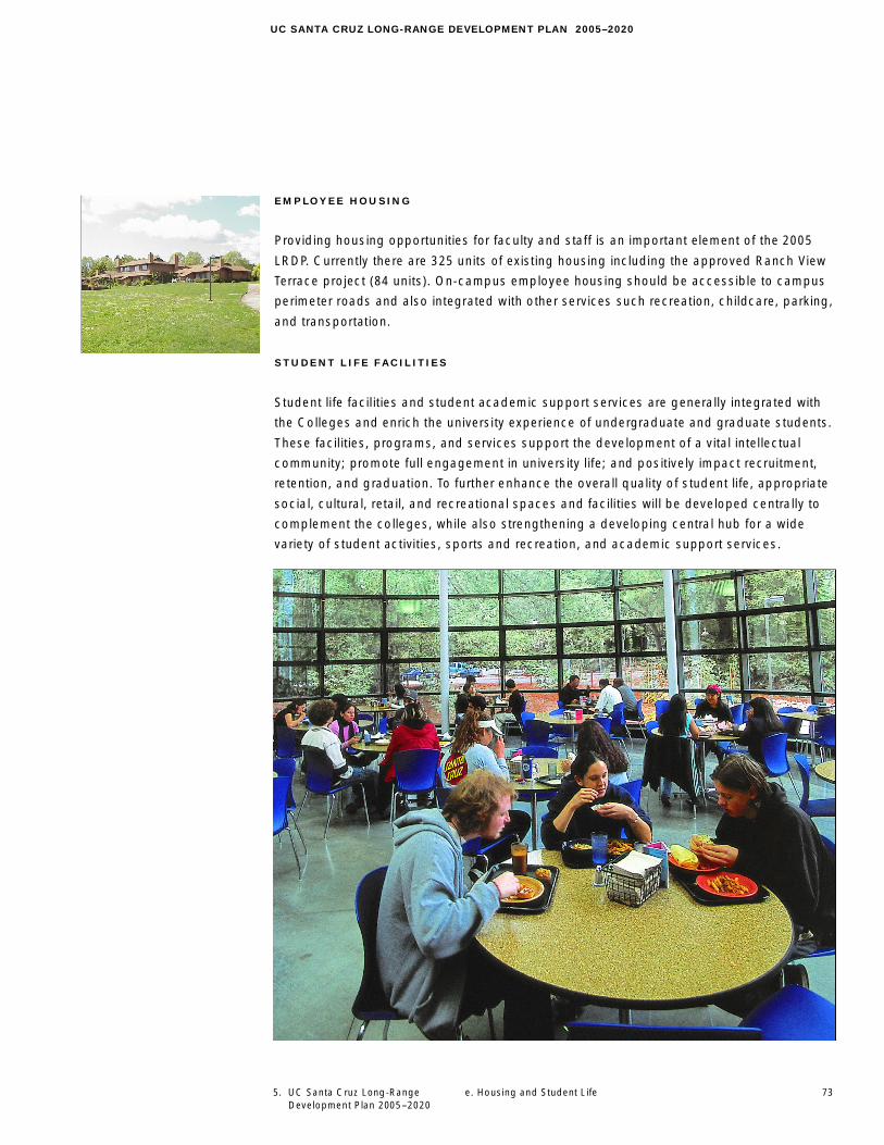
STUDENT L IFE FACIL ITIES
Student life facil ities and student academic support services are generally integrated with
the Colleges and enrich the university experience of undergraduate and graduate students.
These facil ities, programs, and services support the development of a vital intellectual
community; promote full engagement in university life; and positively impact recruitment,
retention, and graduation. To further enhance the overall quality of student life, appropriate
social, cultural, retail, and recreational spaces and facili ties will be developed centrally to
complement the colleges, while also strengthening a developing central hub for a wide
variety of student activities, sports and recreation, and academic support services.
73
74
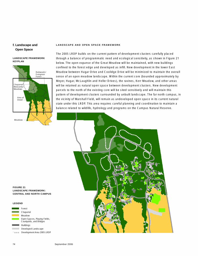
LANDSCAPE AND OPEN SPACE FRAMEWORK
The 2005 LRDP builds on the current pattern of development clusters carefully placed
through a balance of programmatic need and ecological sensitivity, as shown in Figure 21
below. The open expanse of the Great Meadow will be maintained, with new buildings
confined to the forest edge and developed as infill. New development in the lower East
Meadow between Hagar Drive and Coolidge Drive will be minimized to maintain the overall
sense of an open meadow landscape. Within the current core (bounded approximately by
Meyer, Hagar, McLaughlin and Heller Drives), the ravines, Kerr Meadow, and other areas
will be retained as natural open space between development clusters. New development
parcels to the north of the existing core will be sited sensitively and will maintain this
pattern of development clusters surrounded by unbuilt landscape. The far north campus, in
the vicinity of Marshall Field, wil l remain as undeveloped open space in its current natural
state under this LRDP. This area requires careful planning and coordination to maintain a
balance related to wildlife, hydrology and programs on the Campus Natural Reserve.
f. Landscape andOpen Space
LANDSCAPE FRAMEWORKKEYPLAN
Redwoods/EvergreenForest
Meadows
Area ofDetail
FIGURE 21LANDSCAPE FRAMEWORK:CENTRAL AND NORTH CAMPUS
Forest
Chaparral
MeadowOpen Spaces, Playing Fields,Courtyards, and Bridges
Buildings
Developed Landscape
Development Area 2005 LRDP
Chaparral/Manzanita/Meadows
LEGEND
September 2006
UC SANTA CRUZ LONG-RANGE DEVELOPMENT PLAN 2005–2020
5. UC Santa Cruz Long-RangeDevelopment Plan 2005–2020
75f. Landscape and Open Space
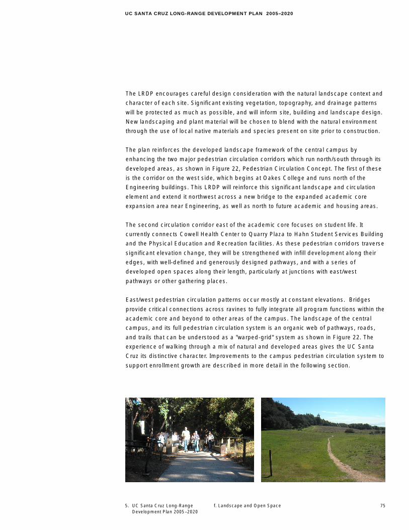
The LRDP encourages careful design consideration with the natural landscape context and
character of each site. Significant existing vegetation, topography, and drainage patterns
will be protected as much as possible, and will inform site, building and landscape design.
New landscaping and plant material will be chosen to blend with the natural environment
through the use of local native materials and species present on site prior to construction.
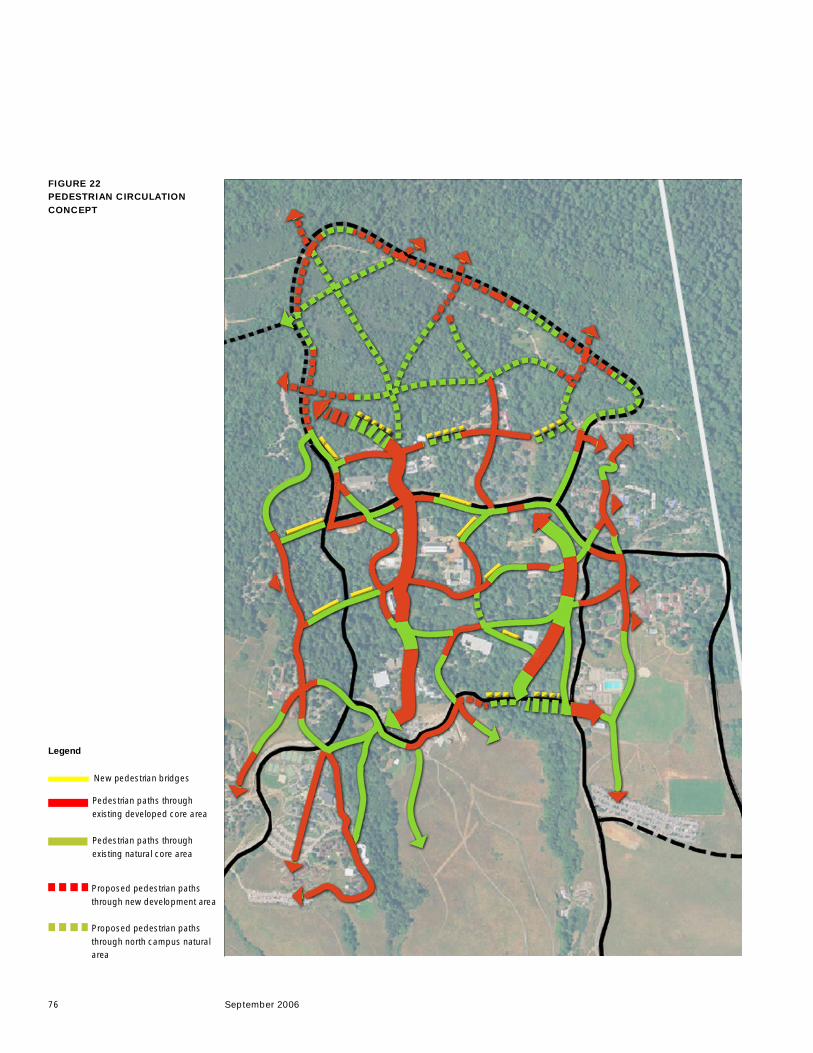
The plan reinforces the developed landscape framework of the central campus by
enhancing the two major pedestrian circulation corridors which run north/south through its
developed areas, as shown in Figure 22, Pedestrian Circulation Concept. The first of these
is the corridor on the west side, which begins at Oakes College and runs north of the
Engineering buildings. This LRDP will reinforce this significant landscape and circulation
element and extend it northwest across a new bridge to the expanded academic core
expansion area near Engineering, as well as north to future academic and housing areas.
The second circulation corridor east of the academic core focuses on student life. It
currently connects Cowell Health Center to Quarry Plaza to Hahn Student Services Building
and the Physical Education and Recreation facili ties. As these pedestrian corridors traverse
significant elevation change, they will be strengthened with infill development along their
edges, with well-defined and generously designed pathways, and with a series of
developed open spaces along their length, particularly at junctions with east/west
pathways or other gathering places.
East/west pedestrian circulation patterns occur mostly at constant elevations. Bridges
provide critical connections across ravines to fully integrate all program functions within the
academic core and beyond to other areas of the campus. The landscape of the central
campus, and its full pedestrian circulation system is an organic web of pathways, roads,
and trails that can be understood as a "warped-grid" system as shown in Figure 22. The
experience of walking through a mix of natural and developed areas gives the UC Santa
Cruz its distinctive character. Improvements to the campus pedestrian circulation system to
support enrollment growth are described in more detail in the following section.
76 September 2006
Pedestrian paths throughexisting developed core area
Pedestrian paths throughexisting natural core area
Proposed pedestrian pathsthrough new development area
Proposed pedestrian pathsthrough north campus naturalarea
FIGURE 22PEDESTRIAN CIRCULATIONCONCEPT
New pedestrian bridges
Legend
77
UC SANTA CRUZ LONG-RANGE DEVELOPMENT PLAN 2005–2020
5. UC Santa Cruz Long-RangeDevelopment Plan 2005–2020
f. Landscape and Open Space
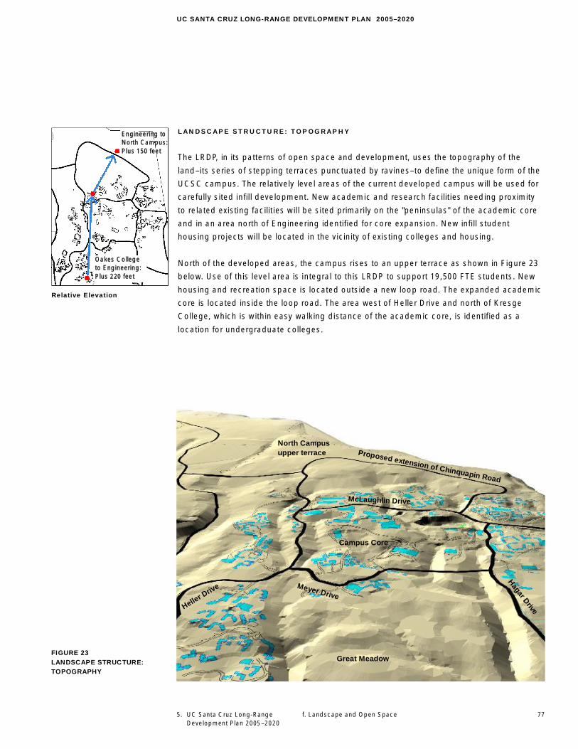
LANDSCAPE STR UCTURE: TOP OGRAPHY
The LRDP, in its patterns of open space and development, uses the topography of the
land–its series of stepping terraces punctuated by ravines–to define the unique form of the
UCSC campus. The relatively level areas of the current developed campus will be used for
carefully sited infill development. New academic and research facilities needing proximity
to related existing facilities will be sited primarily on the "peninsulas" of the academic core
and in an area north of Engineering identified for core expansion. New infill student
housing projects will be located in the vicinity of existing colleges and housing.
North of the developed areas, the campus rises to an upper terrace as shown in Figure 23
below. Use of this level area is integral to this LRDP to support 19,500 FTE students. New
housing and recreation space is located outside a new loop road. The expanded academic
core is located inside the loop road. The area west of Heller Drive and north of Kresge
College, which is within easy walking distance of the academic core, is identified as a
location for undergraduate colleges.
FIGURE 23LANDSCAPE STRUCTURE:TOPOGRAPHY
Engineering toNorth Campus:Plus 150 feet
Oakes Collegeto Engineering:Plus 220 feet
Relative Elevation
Meyer Drive
Hagar Drive
McLaughlin Drive
Heller D
rive
North Campusupper terrace
Campus Core
Great Meadow
Proposed extension of Chinquapin Road
78 September 2006
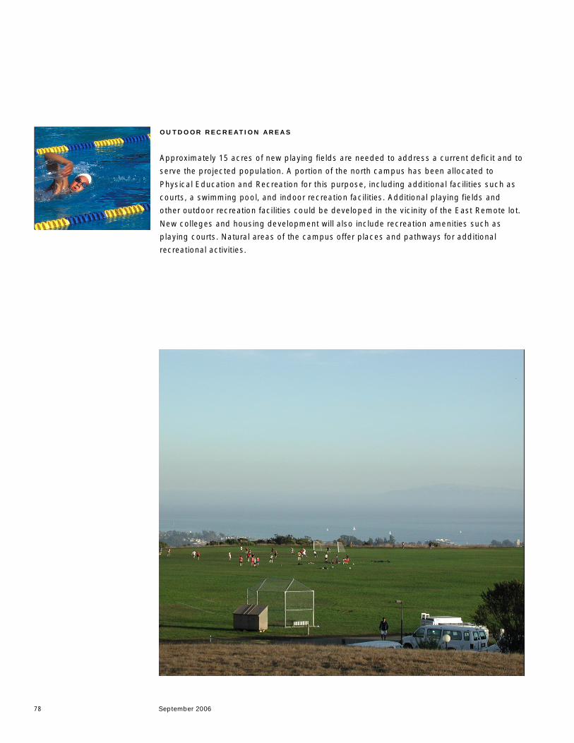
OUTDOOR RECREATION AREA S
Approximately 15 acres of new playing fields are needed to address a current deficit and to
serve the projected population. A portion of the north campus has been allocated to
Physical Education and Recreation for this purpose, including additional facilities such as
courts, a swimming pool, and indoor recreation facilities. Additional playing fields and
other outdoor recreation facilities could be developed in the vicinity of the East Remote lot.
New colleges and housing development will also include recreation amenities such as
playing courts. Natural areas of the campus offer places and pathways for additional
recreational activities.
79
UC SANTA CRUZ LONG-RANGE DEVELOPMENT PLAN 2005–2020
5. UC Santa Cruz Long-RangeDevelopment Plan 2005–2020
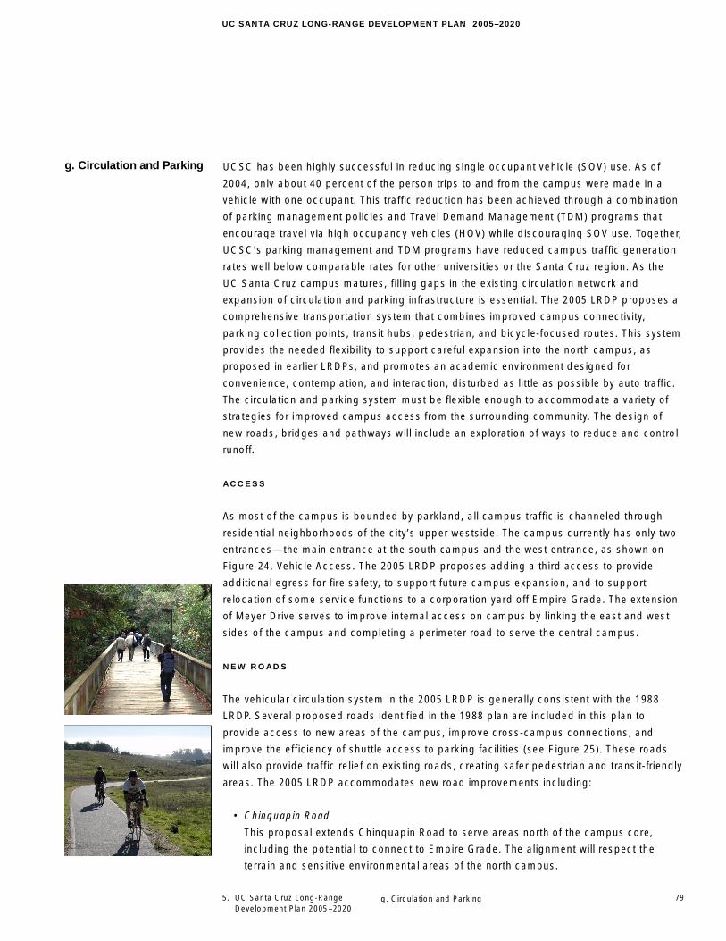
UCSC has been highly successful in reducing single occupant vehicle (SOV) use. As of
2004, only about 40 percent of the person trips to and from the campus were made in a
vehicle with one occupant. This traffic reduction has been achieved through a combination
of parking management policies and Travel Demand Management (TDM) programs that
encourage travel via high occupancy vehicles (HOV) while discouraging SOV use. Together,
UCSC’s parking management and TDM programs have reduced campus traffic generation
rates well below comparable rates for other universities or the Santa Cruz region. As the
UC Santa Cruz campus matures, filling gaps in the existing circulation network and
expansion of circulation and parking infrastructure is essential. The 2005 LRDP proposes a
comprehensive transportation system that combines improved campus connectivity,
parking collection points, transit hubs, pedestrian, and bicycle-focused routes. This system
provides the needed flexibility to support careful expansion into the north campus, as
proposed in earl ier LRDPs, and promotes an academic environment designed for
convenience, contemplation, and interaction, disturbed as little as possible by auto traffic.
The circulation and parking system must be flexible enough to accommodate a variety of
strategies for improved campus access from the surrounding community. The design of
new roads, bridges and pathways will include an exploration of ways to reduce and control
runoff.
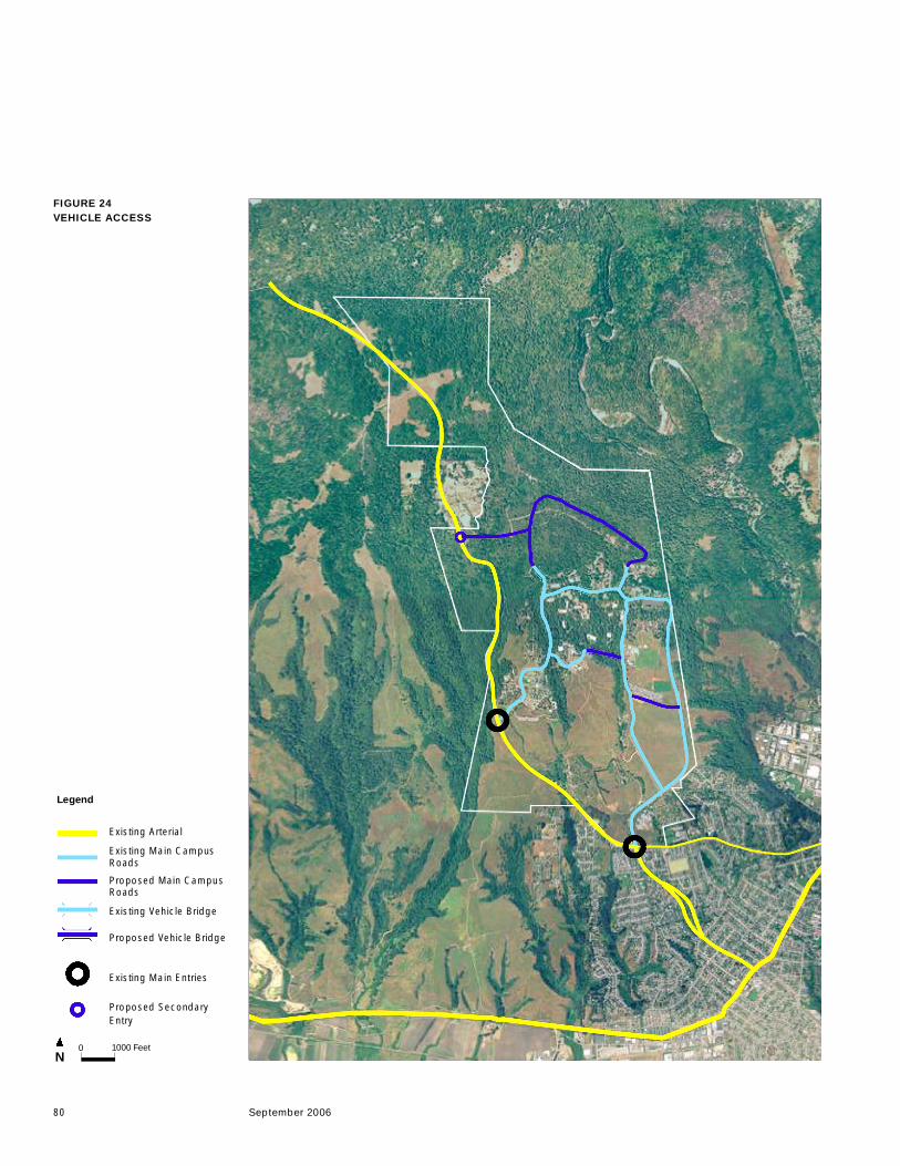
ACCESS
As most of the campus is bounded by parkland, all campus traffic is channeled through
residential neighborhoods of the city’s upper westside. The campus currently has only two
entrances—the main entrance at the south campus and the west entrance, as shown on
Figure 24, Vehicle Access. The 2005 LRDP proposes adding a third access to provide
additional egress for fire safety, to support future campus expansion, and to support
relocation of some service functions to a corporation yard off Empire Grade. The extension
of Meyer Drive serves to improve internal access on campus by linking the east and west
sides of the campus and completing a perimeter road to serve the central campus.
NEW ROADS
The vehicular circulation system in the 2005 LRDP is generally consistent with the 1988
LRDP. Several proposed roads identified in the 1988 plan are included in this plan to
provide access to new areas of the campus, improve cross-campus connections, and
improve the efficiency of shuttle access to parking facil ities (see Figure 25). These roads
will also provide traffic relief on existing roads, creating safer pedestrian and transit-friendly
areas. The 2005 LRDP accommodates new road improvements including:
• Chinquapin Road
This proposal extends Chinquapin Road to serve areas north of the campus core,
including the potential to connect to Empire Grade. The alignment will respect the
terrain and sensitive environmental areas of the north campus.
g. Circulation and Parking
g. Circulation and Parking
80 September 2006
FIGURE 24VEHICLE ACCESS
N0 1000 Feet
Legend
Existing Arterial
Existing Main CampusRoads
Proposed Main CampusRoads
Existing Vehicle Bridge
Proposed Vehicle Bridge
Existing Main Entries
Proposed SecondaryEntry

5. UC Santa Cruz Long-Range Development Plan 2005–2020
81
UC SANTA CRUZ LONG-RANGE DEVELOPMENT PLAN 2005–2020
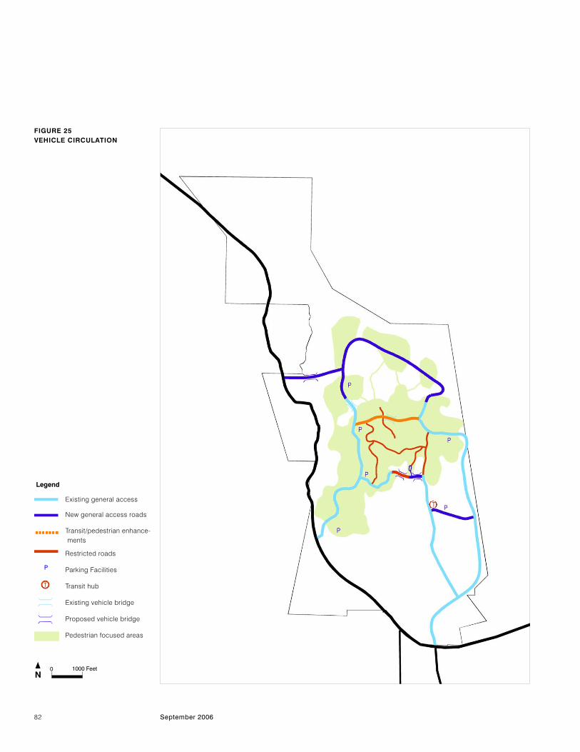
• Heller Drive
Heller Drive is extended past the existing parking lot to connect with Chinquapin
Road. This provides easy access from the new corporation yard to the core.
• Empire Grade Access
This road provides an emergency campus egress to the west, allows service
access, and access for potential employee housing. The road would require a
bridge over the ravine at Cave Gulch.
• Meyer Drive Extension
This proposed new road with two bridges will provide a critical cross-campus
connection from Meyer Drive's existing terminus at the Music Center to Hagar
Drive. The road will be aligned to minimize visual impacts, relieve traffic on
McLaughlin Drive, and introduce a new route for transit vehicles. By bridging to the
Hahn peninsula, the extension will serve the Hahn Student Services building, the
library, and parking areas. Access to Meyer Drive Extension will be designed to serve
either general traffic circulation or restricted access for pedestrian, bicycle, transit, and
service vehicles. This flexibility is achieved as long as the connection to the Hahn
peninsula provides a vehicular turnaround.
• Hagar Drive to Coolidge Drive Connection
This proposed new road will be located along the south edge of the East Remote
parking facility. It will improve the efficiency of ingress and egress at the parking facility
and supports the proposed new transit hub in this vicinity. This connection would allow
for restricted access on the Hagar Drive (between the East Field House and
McLaughlin Drive) as Coolidge Drive/McLaughlin Drive becomes the primary vehicular
route accessing the central campus.
With Coolidge Drive serving as primary access to the central campus, automobile traffic
would be restricted on some roads within the core such as portions of Hagar Drive to
improve pedestrian and bicycle safety and reduce auto traffic at Quarry Plaza. Service and
transit vehicles would be permitted, but these roads would emphasize pedestrian and
bicycle travel.
NEW BRIDGES
New pedestrian and vehicular bridges are an important part of the 2005 LRDP circulation
system (see Figure 25). East/west travel on campus in many areas identified for
development is impeded by ravines. Three new bridges for vehicles and pedestrians are
shown in the 2005 LRDP: one connecting the extension of Chinquapin Road to Empire
Grade and a pair of bridges connecting the Meyer Drive extension to the Hahn peninsula
and on to Hagar Drive. Three additional new bridges are identified for pedestrians north of
McLaughlin to link existing and proposed campus expansion.
g. Circulation and Parking
82 September 2006
FIGURE 25VEHICLE CIRCULATION
Legend
N0 1000 Feet
Existing general access
New general access roads
Transit/pedestrian enhance- ments
Restricted roads
Parking Facilities
Transit hub
Existing vehicle bridge
Proposed vehicle bridge
Pedestrian focused areas
P
g. Circulation and Parking5. UC Santa Cruz Long-Range Development Plan 2005–2020
83
UC SANTA CRUZ LONG-RANGE DEVELOPMENT PLAN 2005–2020
PARKING
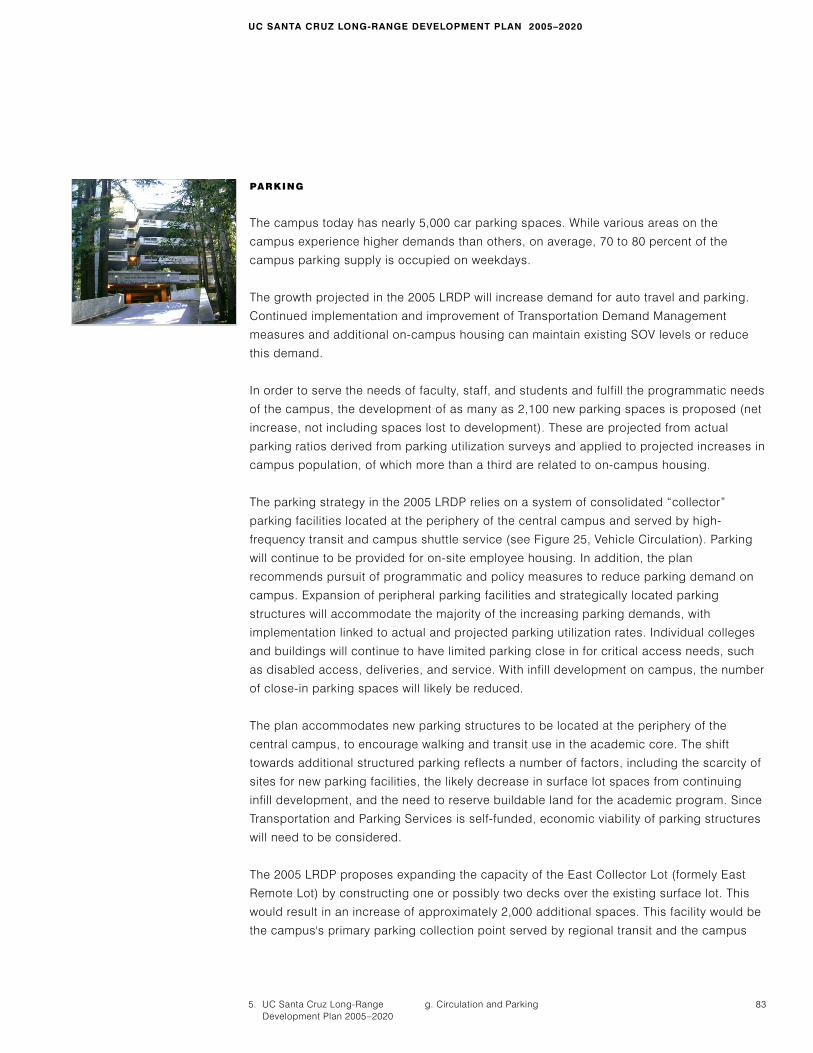
The campus today has nearly 5,000 car parking spaces. While various areas on the
campus experience higher demands than others, on average, 70 to 80 percent of the
campus parking supply is occupied on weekdays.
The growth projected in the 2005 LRDP will increase demand for auto travel and parking.
Continued implementation and improvement of Transportation Demand Management
measures and additional on-campus housing can maintain existing SOV levels or reduce
this demand.
In order to serve the needs of faculty, staff, and students and fulfill the programmatic needs
of the campus, the development of as many as 2,100 new parking spaces is proposed (net
increase, not including spaces lost to development). These are projected from actual
parking ratios derived from parking utilization surveys and applied to projected increases in
campus population, of which more than a third are related to on-campus housing.
The parking strategy in the 2005 LRDP relies on a system of consolidated “collector”
parking facilities located at the periphery of the central campus and served by high-
frequency transit and campus shuttle service (see Figure 25, Vehicle Circulation). Parking
will continue to be provided for on-site employee housing. In addition, the plan
recommends pursuit of programmatic and policy measures to reduce parking demand on
campus. Expansion of peripheral parking facilities and strategically located parking
structures will accommodate the majority of the increasing parking demands, with
implementation linked to actual and projected parking utilization rates. Individual colleges
and buildings will continue to have limited parking close in for critical access needs, such
as disabled access, deliveries, and service. With infill development on campus, the number
of close-in parking spaces will likely be reduced.
The plan accommodates new parking structures to be located at the periphery of the
central campus, to encourage walking and transit use in the academic core. The shift
towards additional structured parking reflects a number of factors, including the scarcity of
sites for new parking facilities, the likely decrease in surface lot spaces from continuing
infill development, and the need to reserve buildable land for the academic program. Since
Transportation and Parking Services is self-funded, economic viability of parking structures
will need to be considered.
The 2005 LRDP proposes expanding the capacity of the East Collector Lot (formely East
Remote Lot) by constructing one or possibly two decks over the existing surface lot. This
would result in an increase of approximately 2,000 additional spaces. This facility would be
the campus's primary parking collection point served by regional transit and the campus
84 September 2006
shuttle system at an adjacent transit hub. A new road connecting Hagar Drive and
Coolidge Drive will improve access to this facility. On the west side of the campus the West
Collector Lot (formerly West Remote) could function in a similar fashion. A collector parking
facility will be located near the arts center, accessible via Heller or Meyer Drives, that may
serve daily and arts events parking needs. A parking collector facility north of Cowell and
Stevenson, accessed from McLaughlin Drive, could serve commuter needs. An additional
parking facility may be located to serve the west side of the expanded academic core.
Each of these structures could have approximately 500-700 spaces.
Limited surface parking will also be provided for new facilities within the central campus to
meet accessibility requirements and to accommodate critical access needs. The location,
amount and type of surface parking will be carefully considered to address storm water
and environmental concerns.
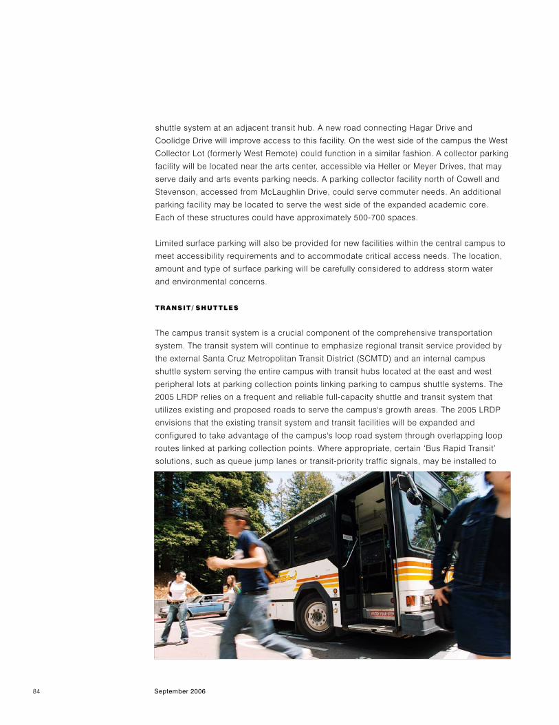
TRANSIT/ SHUTTLES
The campus transit system is a crucial component of the comprehensive transportation
system. The transit system will continue to emphasize regional transit service provided by
the external Santa Cruz Metropolitan Transit District (SCMTD) and an internal campus
shuttle system serving the entire campus with transit hubs located at the east and west
peripheral lots at parking collection points linking parking to campus shuttle systems. The
2005 LRDP relies on a frequent and reliable full-capacity shuttle and transit system that
utilizes existing and proposed roads to serve the campus's growth areas. The 2005 LRDP
envisions that the existing transit system and transit facilities will be expanded and
configured to take advantage of the campus's loop road system through overlapping loop
routes linked at parking collection points. Where appropriate, certain ‘Bus Rapid Transit’
solutions, such as queue jump lanes or transit-priority traffic signals, may be installed to
g. Circulation and Parking5. UC Santa Cruz Long-Range Development Plan 2005–2020
85
UC SANTA CRUZ LONG-RANGE DEVELOPMENT PLAN 2005–2020
allow buses to bypass vehicle backups at intersections. The SCMTD would continue to
provide a local and regional transportation alternative to single occupancy vehicle trips.
PEDESTRIAN CIRCULATION
Walking is the primary mode of travel for students within the academic core and within and
between colleges. The pedestrian system is made up of a network of paths connecting
individual buildings within colleges and inter-connecting the colleges. Most of the roads in
the central campus have sidewalks on at least one side of the road, and to the extent
possible new roads will have sidewalks on both sides. Crosswalks will be provided at
intersections, with preference given to pedestrians inside loop roads.
As described in the Landscape and Open Space section and shown in Figure 23,
north/south pedestrian travel is concentrated along two pedestrian spines. The 2005 LRDP
reinforces and expands on these primary pedestrian spines and enhances east/west
circulation by providing additional pathways and bridges along direct routes between
destinations. In this way, proposed improvements would fill gaps in the circulation system.
The most obvious of these gaps is the lack of connection of Meyer Drive to Hagar Drive.
Extending Meyer Drive to Hagar can connect the East Remote parking and recreation
facilities to the peninsula of land with the Hahn Student Services Building, the student
services corridor, and the central core of campus. Further traffic reduction possibilities,
noted above in the description of new roads, make this dual bridge project a priority.
Another gap is the lack of direct east/west connection between existing parts of the north
academic core. Bridged pedestrian connections are needed between Crown College and
Social Sciences/Colleges Nine and Ten, and between this area and Communications/
Engineering. As the campus expands to the north, the existing pedestrian circulation
system will need to be linked to new development areas. In the north, additions and
upgrades to the existing unpaved roads could form other east/west routes between the
core expansion parcels.
As the campus grows, conflicts between pedestrians and vehicles along roads at key
crossing points will increase, particularly along McLaughlin Drive at Science Hill and south
of Colleges Nine and Ten. Because of the volume of pedestrians flowing between the upper
and lower portions of the campus at class change times, McLaughlin Drive will require
innovative solutions to balance vehicular and pedestrian travel.
One of the challenges will be balancing pedestrian flow with transit schedules. High
volumes of pedestrian crossings can impede transit vehicle travel speed.
86 September 2006
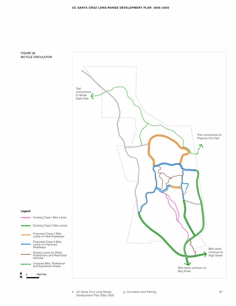
BICYCLE CIRCULATION
Bicycle travel remains an important mode of transportation on campus despite the terrain,
and bicycle travel is expected to grow as on-campus housing increases. The plan strives to
improve the effectiveness and safety of bicycle travel by completing the campus's bicycle
facility system and improving the safety of existing facilities. The bicycle circulation plan
calls for Class II20 bike lanes on major roads throughout the campus, both new and
existing. Where constraints such as topography limit the ability to widen roads, bike lanes
may be installed in the uphill direction, and bikes and vehicles will share the downhill travel
lane, specifically northbound on Heller Drive between Meyer Drive and McLaughlin Drive.
Class III20 bike routes, where bicycles and vehicles share travel lanes, are proposed along
Steinhart and other campus service roads. With the completion of the Meyer Drive
Extension, Hagar Drive between the East Field House and McLaughlin Drive will restrict
automobile traffic, allowing only transit vehicles, pedestrians, and bicycles. With this
improvement, pedestrian and bicycle conflicts with vehicles will be significantly reduced at
Quarry Plaza.
Recreational bike use will continue to be accommodated on designated fire roads and
designated unpaved roads through undeveloped campus lands. As development expands
to the north, the cross-campus regional recreation connection between the Pogonip City
Park and Wilder Ranch State Park will be maintained for pedestrians, bikes, and
equestrians.
Campus bike shuttles and transit services are equipped with bike racks that foster bicycle
use by those unlikely to ride the entire uphill distance to the central campus. Bike parking
facilities will continue to be provided at all major buildings and gathering places.
20.Class II bike lanes provide a striped lane for bicycle use on a road or highway; Class III bike routes provide shared use for bikes and
vehicles on a roadway .
g. Circulation and Parking5. UC Santa Cruz Long-Range Development Plan 2005–2020
87
UC SANTA CRUZ LONG-RANGE DEVELOPMENT PLAN 2005–2020
FFIIGGUURREE 2266BBIICCYYCCLLEE CCIIRRCCUULLAATTIIOONN
N0 1000 Feet
Bike lanes continue onBay Street
Trail connections toPogonip City Park
Trailconnections to WilderState Park
Bike lanescontinue onHigh Street
Legend
Existing Class I Bike Lanes
Existing Class II Bike Lanes
Proposed Class II BikeLanes on New Roadways
Proposed Class II BikeLanes on ImprovedRoadways
Shared Lanes for Bikes,Pedestrians and RestrictedVehicles
Unpaved Bike, Pedestrianand Equestrian Roads
88 September 2006
WATER
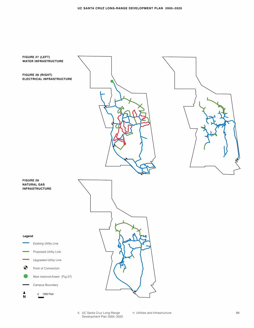
Adequate water supply is a primary issue for UCSC and the City of Santa Cruz given future
anticipated shortfalls under drought conditions. Water is supplied to the campus by the
City of Santa Cruz Water Department. The campus proposes a water management strategy
that builds on existing programs for conservation and explores options for new source
development. In addition, UCSC may explore the viability of possible on-campus water
supply sources subject to test pump and aquifer capacity.
The water supply system is a complex network with four connections to the City of Santa
Cruz system and eight separate pressure zones. Facilities in the campus core will likely
require localized pipe upgrades and campus development north of the existing developed
campus will require new piping and infrastructure elements, including booster pumps to
augment pressure and new storage capacity.
The campus has implemented a range of conservation programs to reduce water
consumption as the campus has grown. The 2005 LRDP calls for continuing these
measures with additional improvements such as continued education efforts, continued
retrofit of existing buildings with more efficient plumbing fixtures, use of ultra-low-flow
fixtures in new buildings, and use of rainwater and/or recycled water if feasible for
irrigation, cooling towers, and other non-potable uses.
ENERGY
Over the past decades, UCSC has actively pursued energy conservation through energy-
efficient new construction practices and energy retrofit programs. The campus will continue
to promote energy efficiency and consistent service quality with demand-reduction
strategies, compliance with the University of California Policy on Green Building Design
and Clean Energy Standards, and self-generation when financially viable.
Campus natural gas and electrical service is supplied by Pacific Gas & Electric (PG&E).
The campus-owned electrical network comprises 21kV primary service lines and 12kV
distribution lines. This network is mostly buried and has a PG&E service connection
northeast of the Hagar Court employee housing complex. Recent campus upgrades have
increased feeder capacity. Future campus growth will increase demands on the campus
electrical infrastructure and require localized upgrades and line extensions in addition to
demand reduction strategies. Reliability of the power supply is particularly important to
UCSC's mission as a research institution and will be a key element of future upgrades.
The natural gas distribution system is owned by UCSC and fashioned as a “ladder” system
with primary piping extending up Heller Drive and Hagar Drive with cross connecting
“ladder rungs” along Meyer Drive and McLaughlin Drive. Recent analysis has indicated a
h. Utilities and Infrastructure
5. UC Santa Cruz Long-Range Development Plan 2005–2020
89
UC SANTA CRUZ LONG-RANGE DEVELOPMENT PLAN 2005–2020
FIGURE 27 (LEFT)WATER INFRASTRUCTURE
Existing Utility Line
Proposed Utility Line
Upgraded Utility Line
Point of Connection
New reservoir/tower (Fig.27)
Campus Boundary
Legend
N0 1000 Feet
h. Utilities and Infrastructure
FIGURE 29 NATURAL GASINFRASTRUCTURE
FIGURE 28 (RIGHT)ELECTRICAL INFRASTRUCTURE

90 September 2006
need for the repair of deteriorated or constrained areas of the network and the replacement
or upgrade of system components to improve network stability and service. The 2005 LRDP
will require extension of service to new development areas and a third pressure regulating
station. In conjunction with demand reduction strategies, these infrastructure
improvements will seek to ensure adequate infrastructure capacity for the plan.
SANITARY SEWER
The existing on-campus sanitary sewer system was sized for 27,500 students and will have
adequate capacity for the proposed new development. There are two major trunk sewers
on the UCSC campus, one on Empire Grade and the other along Hagar Drive, that
combine into a single sewer at the Cook House, which discharges into the city's sewer
system at Bay and High streets. New construction will be limited to repair, maintenance,
limited upgrades, and extensions to areas of new development.
STORM DRAINAGE
The UCSC campus is unique in relying on a series of natural drainage courses and
sinkholes for storm drainage. Storm water drains via a network of pipes into four drainage
arroyos—Jordan Gulch, Moore Creek, Cave Gulch, and San Lorenzo River—which lead to a
series of sinkholes (except for drainage into the San Lorenzo and the lower reach of Moore
watershed). Detention basins and settling tanks serve localized building clusters. While this
system meets current overall capacity requirements, there are localized areas of concern.
Recent analysis has documented surface flooding, concentrated flows, and associated
erosion in some locations. The long-term effect of sediment load on sinkhole capacity is
not known and is difficult to determine. Future development will seek to minimize changes
to existing hydrological conditions and utilize financially viable sustainable design
strategies to manage storm water. These strategies may include minimizing point-source
discharges from buildings and paved surfaces by using infiltration drainage techniques
when feasible; recycling rainwater collected from impervious surfaces for irrigation or other
non-potable uses; or collecting rainwater for controlled aquifer recharge.
DATA NETWORK AND TELECOMMUNICATIONS
Providing data and telecommunications infrastructure with adequate capacity and flexibility
to support the educational and research mission of UCSC is a central element of the 2005
LRDP. This technology will serve the campus itself, link it to off-site facilities, and provide
new opportunities for students, faculty, and staff through initiatives such as distance
learning. Data and telecommunication infrastructure will need to be upgraded to meet
short- and long-term needs for bandwidth/density and reliability. New data and
telecommunications infrastructure should be flexible enough to accommodate new and
emerging technologies.
h. Utilities and Infrastructure5. UC Santa Cruz Long-Range Development Plan 2005–2020
91
UC SANTA CRUZ LONG-RANGE DEVELOPMENT PLAN 2005–2020
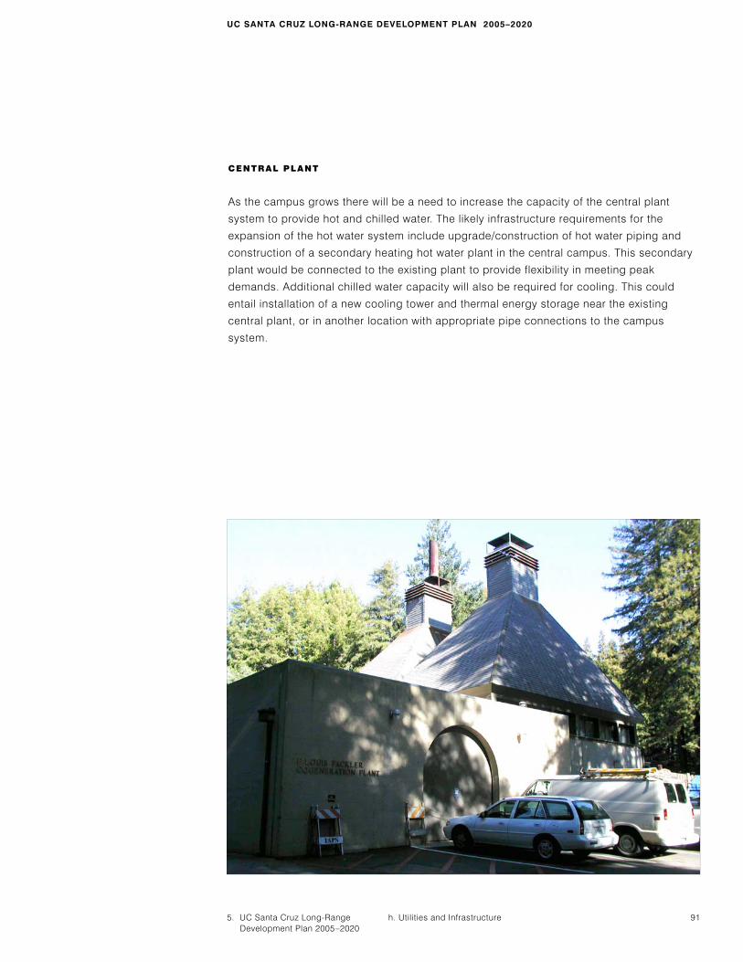
CENTRAL PLANT
As the campus grows there will be a need to increase the capacity of the central plant
system to provide hot and chilled water. The likely infrastructure requirements for the
expansion of the hot water system include upgrade/construction of hot water piping and
construction of a secondary heating hot water plant in the central campus. This secondary
plant would be connected to the existing plant to provide flexibility in meeting peak
demands. Additional chilled water capacity will also be required for cooling. This could
entail installation of a new cooling tower and thermal energy storage near the existing
central plant, or in another location with appropriate pipe connections to the campus
system.