4.1 geology/hazards
TRANSCRIPT

Dalidio/San Luis Marketplace Annexation and Development Project EIR Section 4.1 Geology/Hazards
City of San Luis Obispo 4.1-1
4.1 GEOLOGY/HAZARDS The project site lies within the seismically active coastal region of central California. Regional studies indicate that there are no active or potentially active faults on the project site. However, groundshaking associated with nearby faults could damage or destroy property, structures and transportation infrastructures. These impacts can be mitigated to less than significant levels. In addition, site soils are reported to have a high liquefaction potential, a moderate to high expansion potential and a potential for subsidence. These impacts are considered less than significant with the adherence to mitigation measures. The Dalidio property could potentially be subject to contamination that has migrated from off-site hazardous materials releases. Implementation of recommended mitigation measures, including soils and groundwater testing along the northwestern site boundary to determine the presence of such contamination on site, and appropriate remediation if necessary, would reduce this impact to a less than significant level. The proposed Prado Road/ U.S. Highway 101 interchange and associated improvements could be located on soils that contain residual quantities of aerially-deposited lead (ADL) associated with historic exhaust emissions along U.S. Highway 101. The release of ADL during disturbance of this area would be considered a potentially significant but mitigable health hazard. 4.1.1 Geologic Setting. This section describes the geologic conditions and related hazards of the project site, including faulting, seismically induced ground movement, liquefaction potential, potential for soil expansion/contraction and a subsidence potential.
a. Regional Topography. The Dalidio property is located west of U.S. Highway 101 and east of Madonna Road in an unincorporated area of San Luis Obispo County, California. The Prado Road Interchange portion of the project straddles U.S. Highway 101 both east and west of the highway adjacent to the northeast part of the Dalidio property. The project lies within the San Luis Valley northeast of the Irish Hills and southwest of the southern extent of the Santa Lucia Range. The Irish Hills reach up to 1,800 feet above mean sea level (MSL) and the Santa Lucia Mountains reach up to 2,700 feet above MSL in the San Luis Obispo vicinity. The City of San Luis Obispo is situated at an elevation of approximately 200 feet above MSL with topography generally sloping to the south. The City lies between several low hills and ridges formed by the more resistant volcanic and metavolcanic rocks of the area. The main drainages in the area are the Los Osos Valley which drains westerly into Morro Bay via Los Osos Creek and San Luis Valley which drains to the south-southwest into the Pacific Ocean at Avila Beach via the San Luis Obispo Creek.
b. Regional Geology. San Luis Obispo County lies within the southern Coast Range
Geomorphic Province. This province lies between the Central Valley of California and the Pacific Ocean and extends from Oregon to northern Santa Barbara County. The Coast Range province is structurally complex. It is comprised of sub-parallel northwest-southeast trending faults, folds, and mountain ranges. Rock types in the San Luis Obispo area are mainly comprised of volcanic, metavolcanics, and melanges of serpentinite and graywacke sandstone. These rocks are highly fractured and are part of the Mesozoic aged Franciscan Formation. Intrusive and extrusive volcanic deposits of Tertiary age and marine sedimentary deposits of the Miocene aged Monterey Formation are also found in the area. The most distinctive geomorphological feature of the San Luis Obispo
Dalidio/San Luis Marketplace Annexation and Development Project EIR Section 4.1 Geology/Hazards
City of San Luis Obispo 4.1-2
area is the series of Tertiary aged volcanic plugs (remnants of volcanoes) which extend from the City of San Luis Obispo northwesterly to Morro Bay. Hollister Peak, Bishop Peak, Cerro San Luis Obispo, Islay Hill, and Morro Rock are all comprised of these volcanic plugs. The predominant northwest-southeast trending structures of the Coast Range Province are related to the San Andreas Fault Transform Boundary. This boundary separates two of the major tectonic plates that comprise the earth’s crust. The main feature of the boundary is a right lateral strike slip fault zone, which lies approximately 40 miles to the northeast of San Luis Obispo. West of the San Andreas Fault Transform Boundary lies the Pacific Plate, which is moving in a northwesterly direction relative to the North American Plate east of the boundary. This relative movement between the two plates is the driving force of fault ruptures in western California. The segment of the San Andreas Fault Zone closest to San Luis Obispo was given an earthquake recurrence interval of 206 years with an 18% probability of rupturing between 1994 and 2024 (Southern California Earthquake Center, 1995). Other faults in the San Luis Obispo area that are considered active or potentially active include the San Juan Fault, the East and West Huasna Faults, the Nacimiento Fault Zone, the Oceanic Fault, the Cambria Fault, the Edna Fault, and the Los Osos Fault.
c. Site Topography. The current U.S. Geological Survey (USGS) topographic map of the San Luis Obispo Quadrangle (1965, photorevised 1994) indicated that elevations across the Dalidio property range from 130 to 120 feet above MSL with topography gently sloping south-southwest towards Prefumo Creek with an average slope of approximately 0.5%. The Prado Road interchange portion of the project sits at an elevation of approximately 140 feet above MSL and is essentially flat with a slight regional topographic gradient to the south. The nearest surface body of water is Laguna Lake located adjacent to the northwest of the Dalidio property. Eastern Los Osos Valley and the adjacent highlands, include Sycamore and Prefumo Canyons, all drain into Laguna Lake. The lake is then drained by Prefumo Creek, which begins at the eastern end of the lake and runs southward until its confluence with San Luis Obispo Creek just east of U.S. Highway 101.
d. Site Geology. According to the Geologic Map of California, San Luis Obispo Sheet published by the California Division of Mines and Geology (CDMG) in 1978, the site vicinity is underlain by Quaternary aged alluvium (unconsolidated deposits of sand, silt, clay, and gravel). The surrounding hills are comprised of the Franciscan and Monterey Formations and Quaternary aged non-marine terrace deposits. Groundwater at the site was encountered at 25 to 50 feet below grade according to a hydrograph of an on site well recording water levels from 1989 to 1992 (Phase One Inc., January 1999). These depths to water were pumping levels, and probably overestimate the depth to groundwater during natural conditions. A geotechnical test boring, completed approximately 1,200 feet south-southwest of the subject property, encountered groundwater at 9.5 feet below grade with lithologies of sandy clays and clayey sands (Earth Systems Consultants, October 1997). The nearest fault mapped in the site vicinity by Lettis and Hall (1994) is the Los Osos Fault, which is actually a fault zone that lies approximately 0.5 miles to the southwest of the project site. This fault zone generally trends along the northern flank of the Irish Hills. The Los Osos Fault is capable of a magnitude 6.8 earthquake according to the CDMG. The project site is not located in an Alquist-Priolo Special Study Zone. However, there is an Alquist-Priolo Zone
Dalidio/San Luis Marketplace Annexation and Development Project EIR Section 4.1 Geology/Hazards
City of San Luis Obispo 4.1-3
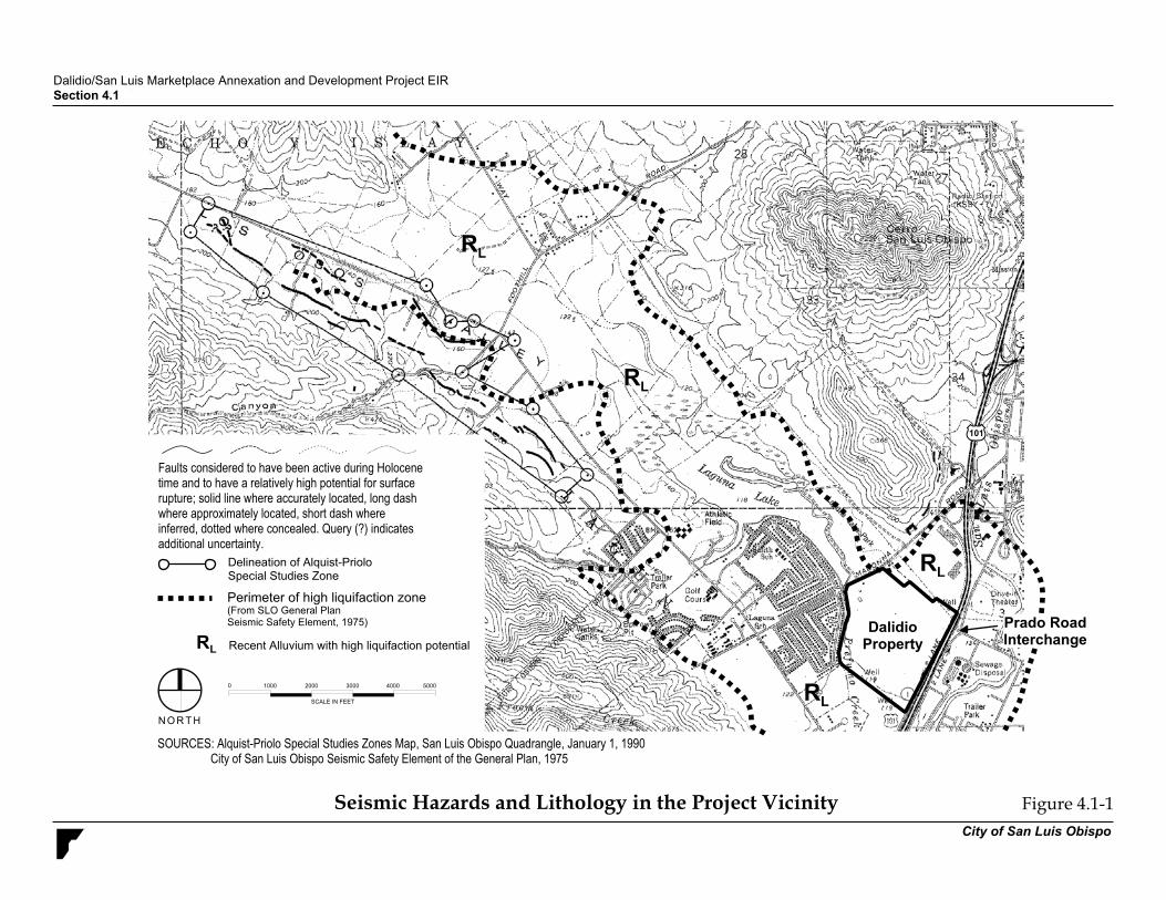
located approximately 1.5 miles west-northwest of the site. This zone delineates an area of relatively high potential for surface rupture associated with an active segment of the Los Osos Fault. Figure 4.1-1 illustrates the Los Osos Fault Zone and the general lithology in the project vicinity. The US Natural Resources Conservation Service has prepared a soil survey for the coastal area of San Luis Obispo County (NRCS, 1977). According to the soil survey, approximately 75% of the Dalidio property soils consist of Cropley Clays and the other 25% (southeast portion) consist of Salinas Silty Clay Loam. The Prado Road Interchange portion of the project is underlain by Salinas Silty Clay Loam. Refer to Figure 4.6-1 in section 4.6, Agricultural Resources, for an illustration of the soil type locations. Cropley Clays develop on 0 to 9% slopes from weathered alluvium derived from sedimentary rocks. These soils form on alluvial fans and plains, are moderately well drained, and are generally about eight feet thick. Cropley clays have a slow permeability and a high water capacity making them unsuitable for septic systems. According to the NRCS soils survey, these soils make poor construction material due to their low strength, high shrink-swell potential (expansiveness), and hardness to pack. Salinas Clay Loams form on 0 to 2% slopes, are well drained, and form on alluvial fans and plains from sedimentary derived alluvium. These soils have a moderately slow permeability and can be up to eight feet thick. Salinas Clay Loams are considered to have a low strength and a moderate shrink swell potential. The soil survey rates it as a fair construction material. Faulting and Seismically Induced Ground Shaking. The U.S. Geological Survey (USGS) and the CDMG defines active faults as those that have had surface displacement within Holocene time (about the last 11,000 years). Surface displacement can be recognized by the existence of cliffs in alluvium, terraces, offset stream courses, fault troughs and saddles, the alignment of depressions, sag ponds, and the existence of steep mountain fronts. Potentially active faults are ones that have had surface displacement during the last 1.6 million years. Inactive faults have not had surface displacement within the last 1.6 million years. The following is a list of active and potentially active faults that could affect the project site: San Andreas Fault Zone. The San Andreas Fault Zone is the dominant active fault in California. The fault is divided into several different segments. These segments include the North Coast, San Francisco Peninsula, Santa Cruz Mountains, Central Creeping, Parkfield, Cholame, Carrizo, Mojave, San Bernadino, and Coachella. The Carrizo segment of the San Andreas Fault is located 38 miles northeast of the project site. It is approximately 145 km long (90 miles) and extends from Cholame down to Three Points. This segment of the San Andreas Fault is capable of producing a moment magnitude 7.2 earthquake (USGS, 1996). Higher magnitudes are possible if multiple contiguous segments rupture simultaneously (this is termed a “cascade” rupture). An estimated magnitude 7.8 earthquake occurred during a cascade type rupture of multiple segments including the Carrizo segment in 1857.
Los Osos Fault. The Los Osos Fault is the closest fault to the project site. It lies approximately 3,000 feet southwest of the property. This reverse fault was given an earthquake recurrence interval of 1,925 years (USGS, 1996). The fault is 44 km (27 miles) long and is capable
� � � � � � � � � � � � � � � � � � � � � � � � � � � � � � � � � � � � � � � � � � � � � � � � � � � � �
� � � � � � � � � � � � � � � � �
� � � � � � � � � � � � � � � � � � � � � � � � � � � � � � � � � � � � � � � � � � � � � �
� � � � � � � � � � � � � � � � � � �
� � � � � � � � �
� � ! "
# $ � % &
'
� ( � � � � # ) � � %
' ' ' * ' ' ' " ' ' ' � ' ' ' + ' ' '
� � � � � � � � � � � � � � � � � � � � � � � � � � � � � � � � � � � � � � � � � � � � � � � � � � � � � � � � � � � � � � � � � � � ! � � � � � " � # � � # $ $ %� � � " � � & � � � � � � � � � � � � � � � � � � ' � � � � & � � " � � � ' � � � � � & � � ( � � ) � � � � � � � � � � � # $ * + �
, � � � � � � � � � � � � � � � � � � ( � - � � � � � � � � � � - � � � � � � � . � � � � � � �� ' � � � � � � � � � ( � - � � � � � � � � - � " � ( ( � � � � � � � � � & � � � � � � & � � � �� � � � � � � / � � � � � � � � 0 ( � � � � � � � � � � � � " � � � � � � � � � � � � � � � ( �0 ( � � � � � � � � � 1 ' � � � " � � � � � � � � � � ( � � � � � � � ( � 0 ( � � � � � & � � � � � � � � � � � � � � 0 ( � � � � � � � � � � � � 2 � � � � � " � 3 4 5 � � � � � � � � �� � � � � � � � � � � � � � � � � " 2 �
� � �
� �
� �
� �
� �
� � � � � � � � � � , - � . - � � / � � , � � � � � 0 � �1 ) � � � � � $ 2 � � � � � � � � � � � � � � � � , � � 3 � � � � � � 4 5 6 + 7 � � � � � �
� � � � � � � �
� � � � � � � � � � , � � / � � � ! � � � � � �� � � � � � � � � � � � � 8 � �
� � � � � � � � � � � � � 9 � � - - � . - � � / � � , � � � � � � � � � � � � �
� �
� � � � � � � � � � �� � � � � � � � � � �
Dalidio/San Luis Marketplace Annexation and Development Project EIR Section 4.1 Geology/Hazards
City of San Luis Obispo 4.1-5
of producing a magnitude 6.8 earthquake. Evidence of Holocene activity of the fault was discovered 1.5 miles west-northwest of the site, giving the fault an active status. Exploratory trenching was performed to locate the fault in an area approximately 2,000 feet southwest of the project site. The trenching study did not find evidence of the fault (Earth Systems Consultants, 1997).
The Rinconada Fault. The Rinconada Fault is located approximately 10 miles northeast of the project site. This potentially active right lateral strike slip fault is approximately 189 km (117 miles) long and is capable of producing a 7.3 magnitude earthquake. Hosgri Fault. The Hosgri Fault is located offshore approximately 12 miles west of the project site. This right lateral strike slip fault is considered active and has a length of approximately 172-km (106 miles). The Hosgri fault is reported to be capable of producing a magnitude 7.3 earthquake.
San Juan Fault. The San Juan Fault is located approximately 30 miles to the east-northeast of the project site. This right lateral strike slip fault is a direct splay of the San Andreas Fault and is considered potentially active. The fault is 68 km (42 miles) in length and is capable of producing a magnitude 7.0 earthquake. Other faults such as the La Panza, the East and West Huasna Faults, the Oceanic Fault, the Cambria Fault, and the Edna Fault are all within 18 miles of the site and are considered potentially active. However, the rupture histories and specific geometries of these faults are not as well understood as the faults mentioned above. The San Andreas and Los Osos Faults are the most likely to affect the project site. The San Andreas Fault has the highest probability of rupture and the Los Osos Fault is in closest proximity to the site. Faults generally produce damage in two ways: ground shaking and surface rupture. Ground shaking covers a wide area and is greatly influenced by the distance of the site to the seismic source, soil conditions, and depth to groundwater. Surface rupture is limited to very near the fault. Earthquake-generated ground shaking is the greatest cause of widespread damage in an earthquake. Recent modeling efforts (probabilistic modeling) have attempted to evaluate earthquake potential for a given area by factoring several potential fault sources. CDMG (1996) has estimated that in the next 50 years, there is a 10 percent probability of an earthquake between magnitudes 7.0 and 7.5 causing peak ground accelerations ranging from 0.2g to 0.3g in the site vicinity. The probability of surface rupture occurring at the site is very low. Although the Los Osos Fault is in near proximity to the site, evidence of the fault trace is not found at the site or at sites to the southwest, which are actually aligned within the fault’s general trend. Liquefaction. Liquefaction is a temporary, but substantial, loss of shear strength in granular solids, such as sand, silt, and gravel, usually occurring during or after a major earthquake. This occurs when the shock waves from an earthquake of sufficient magnitude and duration compact and decrease the volume of the soil; if drainage cannot occur, this reduction
Dalidio/San Luis Marketplace Annexation and Development Project EIR Section 4.1 Geology/Hazards
City of San Luis Obispo 4.1-6
in soil volume will increase the pressure exerted on the water contained in the soil, forcing it upward to the ground surface. This process can transform stable granular material into a fluid-like state. The potential for liquefaction to occur is greatest in areas with loose, granular, low-density soil, where the water table is within the upper 40 to 50 feet of the ground surface. Liquefaction can result in slope and/or foundation failure. The project site was identified in the Safety Element of the San Luis Obispo General Plan as being located in an area of very high liquefaction potential. Figure 4.1-1 delineates the liquefaction hazard zone in the project vicinity. Soil Hazards. Geologic hazards of concern that are not seismically induced events at the site include soils hazards such as settlement, expansive soils, and subsidence. Slope stability is not a concern due to the subtle topography of the site. However, slope stability issues could arise as a result of future grading activities.
Settlement. Settlement is the downward movement of the land surface resulting from the compression of void space in underlying soils. This compression can occur naturally with the accumulation of sediments over porous alluvial soils within river valleys. Settlement can also result from human activities including improperly placed artificial fill, and structures built on soils or bedrock materials with differential settlement rates. This phenomenon can alter local drainage patterns and result in structural damage. The project site is identified as possibly being underlain by soft organic soils. This gives the site a high potential for settlement.
Expansive Soils. Expansive soils are soils that are generally clayey, swell when wetted and shrink when dried. Wetting can occur in a number of ways (i.e., absorption from the air, rainfall, groundwater fluctuations, lawn watering, broken water or sewer lines, etc.). Soil expansion can cause subtle damage that can reduce structural integrity. The project area is located in an area identified as having a moderate to high potential for expansion.
Subsidence. Subsidence is the sinking of the ground surface caused by compression or collapse of earth materials. Subsidence can be caused by both groundwater extraction or seismically induced liquefaction. Groundwater withdrawal subsidence results from the extraction of groundwater from an unconsolidated aquifer. As water is removed from the aquifer, the total weight of the overburden, which was supported in part by hydrostatic pressure, is placed on the soil matrix compressing the now empty void spaces. This compaction produces a net loss in volume and hence; a subsidence of the land surface. Damage caused by this type of subsidence is generally not of an immediate or violent nature. The consolidation of alluvium and settling of the land surface is a process that often occurs over many years, except when prompted by seismic shaking or wetting of highly collapsible soils. During the drought years between 1987-1991, groundwater levels in the site vicinity were lowered enough to cause subsidence. Soft organic soils were compressed when dewatered causing subsidence and some structural damage in areas north of Los Osos Valley Road (Earth Systems Consultants, 1998). e. Potential Sources of Soil and Groundwater Contamination. A “Limited Level I Preliminary Site Assessment” was prepared for the proposed Prado Road/U.S. Highway 101 interchange (PAR Environmental Services, Inc., August 2000). A records search of Federal, State, and County hazardous materials incident databases on and in the vicinity of the project site was conducted by Environmental Data Resources, Inc. (February 10, 2003). This records
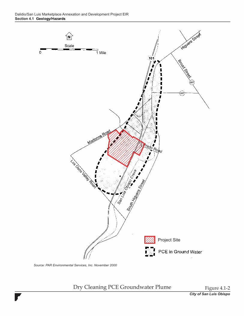
Dalidio/San Luis Marketplace Annexation and Development Project EIR Section 4.1 Geology/Hazards
City of San Luis Obispo 4.1-7
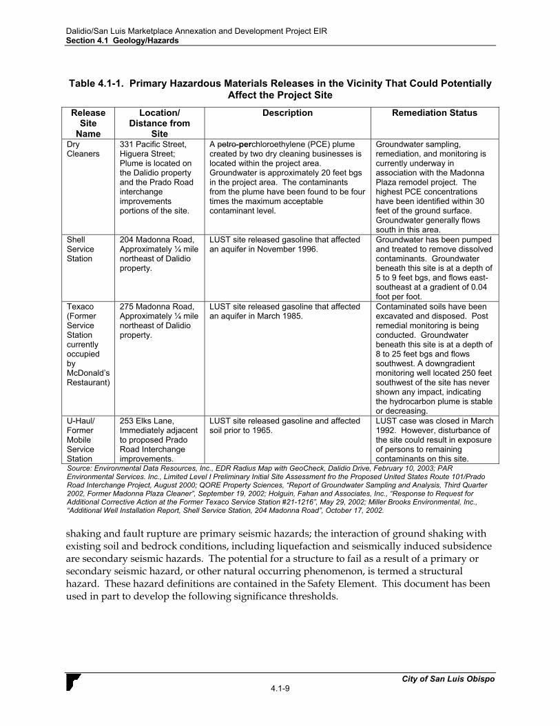
search identified government-regulated properties having known or potential recognized hazardous materials conditions within the site vicinity. Based on this records review, the project site is not listed on a local, state, or federal hazardous materials database. However, several registered users of hazardous materials are located in the project vicinity. Most of these hazardous materials sites are commercial or institutional uses located along U.S. Highway 101, Madonna Road, and Los Osos Valley Road. Nine of these sites involved a release of hazardous materials within ¼ mile of the project site. For the purposes of this evaluation, ¼ mile is the maximum distance a contaminant released from a leaking underground storage tank (LUST) could reasonably be expected to migrate. The hazardous materials releases located within ¼ mile of the project site are summarized in Table 4.1-1. As shown in Table 4.1-1, four LUST sites within ¼ mile of the project site involved a release that could potentially affect the project site. Two of these sites, the Shell and Texaco Service Stations, affected an aquifer and are located upgradient (i.e., at a higher elevation) from the Dalidio property. Remediation is underway, but not yet complete, for both of these sites (Holguin, Fahan and Associates, Inc., “Response to Request for Additional Corrective Action at the Former Texaco Service Station #21-1216, May 29, 2002; Miller Brooks Environmental, Inc., “Additional Well Installation Report, Shell Service Station, 204 Madonna Road”, October 17, 2002). An extensive petro-perchloroethylene (PCE) plume created by two dry cleaning businesses is located within the Dalidio property and Prado Road interchange improvements area (refer to Figure 4.1-2). This large plume is currently being remediated on the Madonna Plaza property, but is not yet complete (QORE Property Sciences, “Report of Groundwater Sampling and Analysis, Third Quarter 2002, Former Madonna Plaza Cleaner”, September 19, 2002). Additionally, the project would include the acquisition of the existing U-Haul property for the implementation of the Prado Road interchange. Although the LUST case at the U-Haul property has been closed, quantities of hazardous materials could remain at this property. Table 4.1-2 summarizes recorded hazardous materials sites within ¼ mile of the project site that involved releases that would not be expected affect the project site due to the distance between the release and the project site, the direction and gradient of groundwater, the magnitude of the release, and/or the hazardous release case status (e.g., remediation has been completed). The historic and continued use of the Dalidio property for agricultural production is assumed to involve the use of agricultural chemicals (pesticides, herbicides, fertilizers). The use and storage of these chemicals on the project site could have resulted in undocumented releases of contaminants. In addition, due to the historic application of agricultural chemicals on the project site, residual quantities of these chemicals, including presently banned agricultural chemicals, could occur in on-site soils. 4.1.2 Impact Analysis. a. Methodology and Thresholds of Significance. This evaluation is based on review of existing information that has been developed for the City of San Luis Obispo in the City of San Luis Obispo General Plan and Safety Element. Impacts are considered significant if known hazards are identified that could adversely affect the project. In addition, the City of San Luis Obispo has established thresholds of significance for most geological conditions. The San Luis Obispo Safety Element (July 2000) contains hazard definitions stating that ground
Dalidio/San Luis Marketplace Annexation and Development Project EIRSection 4.1 Geology
Dry Cleaning PCE Groundwater Plume Figure 4.1-2City of San Luis Obispo
Source: PAR Environmental Services, Inc. November 2000
Project Site
Dalidio/San Luis Marketplace Annexation and Development Project EIR Section 4.1 Geology/Hazards
City of San Luis Obispo 4.1-9
Table 4.1-1. Primary Hazardous Materials Releases in the Vicinity That Could Potentially
Affect the Project Site
Release Site
Name
Location/ Distance from
Site
Description Remediation Status
Dry Cleaners
331 Pacific Street, Higuera Street; Plume is located on the Dalidio property and the Prado Road interchange improvements portions of the site.
A petro-perchloroethylene (PCE) plume created by two dry cleaning businesses is located within the project area. Groundwater is approximately 20 feet bgs in the project area. The contaminants from the plume have been found to be four times the maximum acceptable contaminant level.
Groundwater sampling, remediation, and monitoring is currently underway in association with the Madonna Plaza remodel project. The highest PCE concentrations have been identified within 30 feet of the ground surface. Groundwater generally flows south in this area.
Shell Service Station
204 Madonna Road, Approximately ¼ mile northeast of Dalidio property.
LUST site released gasoline that affected an aquifer in November 1996.
Groundwater has been pumped and treated to remove dissolved contaminants. Groundwater beneath this site is at a depth of 5 to 9 feet bgs, and flows east-southeast at a gradient of 0.04 foot per foot.
Texaco (Former Service Station currently occupied by McDonald’s Restaurant)
275 Madonna Road, Approximately ¼ mile northeast of Dalidio property.
LUST site released gasoline that affected an aquifer in March 1985.
Contaminated soils have been excavated and disposed. Post remedial monitoring is being conducted. Groundwater beneath this site is at a depth of 8 to 25 feet bgs and flows southwest. A downgradient monitoring well located 250 feet southwest of the site has never shown any impact, indicating the hydrocarbon plume is stable or decreasing.
U-Haul/ Former Mobile Service Station
253 Elks Lane, Immediately adjacent to proposed Prado Road Interchange improvements.
LUST site released gasoline and affected soil prior to 1965.
LUST case was closed in March 1992. However, disturbance of the site could result in exposure of persons to remaining contaminants on this site.
Source: Environmental Data Resources, Inc., EDR Radius Map with GeoCheck, Dalidio Drive, February 10, 2003; PAR Environmental Services. Inc., Limited Level I Preliminary Initial Site Assessment fro the Proposed United States Route 101/Prado Road Interchange Project, August 2000; QORE Property Sciences, “Report of Groundwater Sampling and Analysis, Third Quarter 2002, Former Madonna Plaza Cleaner”, September 19, 2002; Holguin, Fahan and Associates, Inc., “Response to Request for Additional Corrective Action at the Former Texaco Service Station #21-1216”, May 29, 2002; Miller Brooks Environmental, Inc., “Additional Well Installation Report, Shell Service Station, 204 Madonna Road”, October 17, 2002. shaking and fault rupture are primary seismic hazards; the interaction of ground shaking with existing soil and bedrock conditions, including liquefaction and seismically induced subsidence are secondary seismic hazards. The potential for a structure to fail as a result of a primary or secondary seismic hazard, or other natural occurring phenomenon, is termed a structural hazard. These hazard definitions are contained in the Safety Element. This document has been used in part to develop the following significance thresholds.
Dalidio/San Luis Marketplace Annexation and Development Project EIR Section 4.1 Geology/Hazards
City of San Luis Obispo 4.1-10
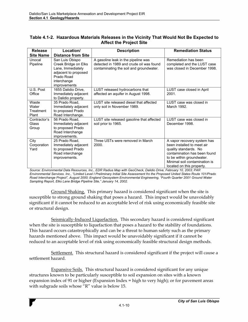
Table 4.1-2. Hazardous Materials Releases in the Vicinity That Would Not Be Expected to
Affect the Project Site
Release Site Name
Location/ Distance from Site
Description Remediation Status
Unocal Pipeline
San Luis Obispo Creek Bridge on Elks Lane, Immediately adjacent to proposed Prado Road interchange improvements
A gasoline leak in the pipeline was detected in 1989 and crude oil was found contaminating the soil and groundwater.
Remediation has been completed and the LUST case was closed in December 1998.
U.S. Post Office
1655 Dalidio Drive, Immediately adjacent to Dalidio property.
LUST released hydrocarbons that affected an aquifer in August 1998.
LUST case closed in April 2001.
Waste Water Treatment Plant
35 Prado Road, Immediately adjacent to proposed Prado Road Interchange.
LUST site released diesel that affected only soil in November 1989.
LUST case was closed in March 1992.
Contractor’s Glass Group
56 Prado Road, Immediately adjacent to proposed Prado Road Interchange improvements.
LUST site released gasoline that affected soil prior to 1965.
LUST case was closed in December 1998.
City Corporation Yard
25 Prado Road, Immediately adjacent to proposed Prado Road interchange improvements.
Three USTs were removed in March 2000.
A vapor recovery system has been installed to meet air quality standards. No contamination has been found to be within groundwater. Minimal soil contamination is located on this property.
Source: Environmental Data Resources, Inc., EDR Radius Map with GeoCheck, Dalidio Drive, February 10, 2003; PAR Environmental Services. Inc., “Limited Level I Preliminary Initial Site Assessment fro the Proposed United States Route 101/Prado Road Interchange Project”, August 2000; England Geosystem Environmental Engineering, “Fourth Quarter 2001 Ground Water Sampling Report, Elks Lane Bridge Pipeline Site,” January 14, 2002. Ground Shaking. This primary hazard is considered significant when the site is susceptible to strong ground shaking that poses a hazard. This impact would be unavoidably significant if it cannot be reduced to an acceptable level of risk using economically feasible site or structural design. Seismically-Induced Liquefaction. This secondary hazard is considered significant when the site is susceptible to liquefaction that poses a hazard to the stability of foundations. This hazard occurs catastrophically and can be a threat to human safety such as the primary hazards mentioned above. This impact would be unavoidably significant if it cannot be reduced to an acceptable level of risk using economically feasible structural design methods. Settlement. This structural hazard is considered significant if the project will cause a settlement hazard. Expansive Soils. This structural hazard is considered significant for any unique structures known to be particularly susceptible to soil expansion on sites with a known expansion index of 91 or higher (Expansion Index = high to very high); or for pavement areas with subgrade soils whose “R” value is below 15.
Dalidio/San Luis Marketplace Annexation and Development Project EIR Section 4.1 Geology/Hazards
City of San Luis Obispo 4.1-11
Subsidence. This structural hazard is considered significant if the project will cause or be subject to a subsidence hazard. Pursuant to the State CEQA Guidelines, project implementation would create a significant impact relative to geologic resources if it would result in any of the following conditions:
• Expose people or structures to potential substantial adverse effects, including the risk of
loss, injury, or death involving rupture of a known earthquake fault, strong seismic ground shaking, seismic-related ground failure, including liquefaction, or landslides;
• Result in substantial soil erosion or the loss of topsoil; • Result in the loss of a unique geologic feature; • Be located on a geologic unit or soil that is unstable, or that would become unstable as a
result of the project, and potentially result in on- or off-site landslide, lateral spreading, subsidence, liquefaction, or collapse;
• Be located on expansive soil, creating substantial risks to life or property; or • Have soils incapable of adequately supporting the use of septic tanks or alternative
wastewater disposal systems where sewers are not available for the disposal of wastewater.
b. Project Impacts and Mitigation Measures. Impact GEO-1 Seismically induced ground shaking could destroy or damage
structures and infrastructure developed for the project site, resulting in loss of property or risk to human health. This is considered a Class II, significant but mitigable impact.
The strongest ground-shaking event at the site is calculated to occur from a rupture of the Los Osos Fault. However, the probability of this occurring is substantially less than the probability of a rupture occurring along the San Andreas Fault. A cascade type multiple segment rupture along the San Andreas Fault is estimated to produce a maximum moment magnitude earthquake of 7.8 (based on data from the 1857 earthquake). Peak ground accelerations that could be expected from earthquakes produced by selected faults in the region are listed in Table 4.1-2. These faults are not the only faults in the area that can produce earthquakes, but they are the most probable to affect the project site according to the latest data. Earthquakes along these faults could produce potentially significant impacts to structures on-site. Although nothing can ensure that structures do not fail under seismic stress, proper engineering, including the measures identified below, can minimize the risk to life and property.
Table 4.1-3 Estimated Ground Accelerations
Fault Name
Maximum Credible Earthquake Magnitude1
Distance in miles/ (km) from site
Estimated Ground Acceleration at Site
(g)2 San Andreas 7.8 38/(61) 0.12
Los Osos 6.8 0.57/(0.9) 0.6 Rinconada 7.3 10/(16) 0.3 San Juan 7.0 30/(48) 0.1
Hosgri 7.3 12/(19.2) 0.25 1-CDMG. Probabilistic Seismic Hazard Assessment for the State of California (1996) 2-Idriss (1985)
Dalidio/San Luis Marketplace Annexation and Development Project EIR Section 4.1 Geology/Hazards
City of San Luis Obispo 4.1-12
Mitigation Measures. The following measures would reduce seismic hazard impacts to less than significant levels:
GEO-1(a) Design and construction of the buildings, roadway infrastructure and all subgrades shall be engineered to withstand the expected ground acceleration that may occur at this site. The design should take into consideration the soil type, potential for liquefaction, and the most current and applicable seismic attenuation methods that are available. All on-site structures shall comply with applicable provisions of the Uniform Building Code and the most recent California Department of Transportation seismic design standards.
GEO-1(b) For retail stores included in the San Luis Obispo Marketplace, goods for
sale may be stacked no higher than 8 feet from the floor in any area where customers are present, unless provisions are made to prevent the goods from falling during an earthquake of up to 7.5 magnitude. The stacking or restraint methods shall be reviewed and approved by the City before approval of occupancy permits, and shall be a standing condition of occupancy.
Significance After Mitigation. The probability of a larger than expected earthquake with higher ground accelerations to occur is never zero. Any structure built in California is susceptible to failure due to seismic activity. However, structural failure due to seismic ground shaking would be reduced to a less than significant level by implementing the most recent industry standards for structural designs.
Impact GEO-2 Seismic activity could produce sufficient ground shaking to result in liquefaction at the project site. This is considered a Class II, significant but mitigable impact.
Unconsolidated alluvial material and shallow groundwater underlie the project site. Because of the combination of soil and groundwater underlying both the Dalidio property and Dalidio Drive, the project site has been classified as an area of very high liquefaction potential in the City of San Luis Obispo Safety Element. Therefore, the risk to structures and people due to liquefaction at the site is considered a significant impact.
Mitigation Measures. The following measures would reduce liquefaction hazard impacts to less than significant levels:
GEO-2(a) A geotechnical study shall be prepared for the project site prior to site development. This report shall include an analysis of the liquefaction potential of the underlying materials according to the most current liquefaction analysis procedures. If the site is confirmed to be in an area prone to seismically-induced liquefaction, appropriate techniques to minimize liquefaction potential shall be prescribed and implemented. All on-site structures, transportation infrastructure and subgrades shall comply with applicable methods of the Uniform Building Code and all

Dalidio/San Luis Marketplace Annexation and Development Project EIR Section 4.1 Geology/Hazards
City of San Luis Obispo 4.1-13
transportation infrastructure shall comply with the most current California Department of Transportation design standards.
Suitable measures to reduce liquefaction impacts could include one or more of the following techniques, as determined by a registered geotechnical engineer:
• specialized design of foundations by a structural engineer; • removal or treatment of liquefiable soils to reduce the potential for
liquefaction; • drainage to lower the groundwater table to below the level of liquefiable
soil; • in-situ densification of soils or other alterations to the ground
characteristics; or • other alterations to the ground characteristics.
Significance After Mitigation. Implementation of the above mitigation measure will address impacts related to seismically induced liquefaction to the extent of industry standards, and will therefore be less than significant.
Impact GEO-3 The project site is located in an area defined as having a high potential for settlement. This is considered a Class II, significant but mitigable impact.
The potential for settlement beneath the project site is characterized as high due to the presence of very soft organic soils. Because the characteristics of soils can vary widely within short distances, the impacts from the potential for settlement are presumed to be significant. Detailed geologic studies are required prior to development to evaluate the potential for settlement. If the project site is found to have a high potential for settlement, impacts can be mitigated through proper foundation design and/or grading. Mitigation Measures. The following measures would reduce settlement hazard impacts to less than significant levels:
GEO-3(a) Measure GEO-2 (Site Geotechnical Investigation) shall include an evaluation of the potential for soil settlement beneath the project site.
GEO-3(b) If the project site is identified to be in a high potential for settlement zone
based on the Site Geotechnical Investigation, the building foundations, transportation infrastructure and subgrades shall be designed by a structural engineer to withstand the existing conditions, or the site shall be graded in such a manner as to address the condition.
Suitable measures to reduce settlement impacts could include one or more of the following techniques, as determined by a qualified geotechnical engineer:
Dalidio/San Luis Marketplace Annexation and Development Project EIR Section 4.1 Geology/Hazards
City of San Luis Obispo 4.1-14
• excavation and recompaction of on-site or imported soils; • treatment of existing soils by mixing a chemical grout into the soils prior
to recompaction; or • foundation design that can accommodate certain amounts of differential
settlement such as post tensional slab and/or ribbed foundations designed in accordance with Chapter 18, Division III of the Uniform Building Code(UBC).
Significance After Mitigation. If the mitigation measures above are implemented, the
impacts related to soil settlement would be reduced to a less than significant level.
Impact GEO-4 The project site is located in an area defined as having moderate to high potential for the expansion or contraction of soils. This is considered a Class II, significant but mitigable impact.
The potential for expansive soil beneath the site is characterized as moderate to high. Because the characteristics of soils can vary widely within short distances, depending on the relative amount and type of clay, the impacts from the potential for soil expansion are presumed to be significant. Detailed geologic studies are required prior to development to evaluate the potential for expansive soils. If the site is found to have expansive soils, this impact can be mitigated through proper foundation design. Mitigation Measures. The following measures would reduce soil expansion/contraction hazard impacts to less than significant levels:
GEO-4(a) Measure GEO-2 (Site Geotechnical Investigation) shall include an evaluation of the potential for soil expansion beneath the project site.
GEO-4(b) If the project site is identified to be in a high expansive soil zone based on
the Site Geotechnical Investigation, the foundations and transportation infrastructure shall be designed by a structural engineer to withstand the existing conditions, or the site shall be graded in such a manner as to address the condition.
Suitable measures to reduce impacts from expansive soils could include one or more of the following techniques, as determined by a qualified geotechnical engineer:
• excavation of existing soils and importation of non-expansive soils; and • foundation design to accommodate certain amounts of differential
expansion such as post tensional slab and/or ribbed foundations designed in accordance with Chapter 18, Division III of the UBC.
Significance After Mitigation. If the mitigation measures above are implemented, the impacts related to soil expansion would be reduced to a less than significant level.
Dalidio/San Luis Marketplace Annexation and Development Project EIR Section 4.1 Geology/Hazards
City of San Luis Obispo 4.1-15
Impact GEO-5 The proposed project site is located in an area designated as being exposed to potential subsidence. This is considered a Class II, significant but mitigable impact.
Unconsolidated alluvial materials underlying the majority of the site could subside if supporting materials are removed, or during earthquakes. Increased groundwater extraction during droughts has historically caused subsidence in the area. If existing groundwater levels were to be lowered below the levels that caused subsidence in the past, additional subsidence may occur.
Mitigation Measures. The following measures would reduce subsidence hazard impacts to a less than significant level: GEO-5(a) Measure GEO-2 (Site Geotechnical Investigation) shall include soil
parameter analyses to determine the potential for subsidence at the project site. If the potential for subsidence is found to be significant, then structural and grading engineering measures shall be implemented to incorporate the results of the geotechnical study. These measures would be similar to those recommended to mitigate impacts to soil settlement.
GEO-5(b) During future droughts, groundwater pumping limitations for the
unconsolidated aquifer underlying the project site shall be assessed and implemented to prevent soil subsidence.
Significance After Mitigation. If the mitigation measures mentioned above are
implemented, the impacts related to subsidence would be reduced to less than significant.
Impact GEO-6 Existing hazardous materials releases from off-site properties could potentially affect the subject property. In addition, project development would occur in an area historically used for agricultural production with soils that could contain residual quantities of presently-banned agricultural chemicals. The exposure of site construction workers and occupants to these contaminants is considered a Class II, significant but mitigable impact.
A “Limited Level I Preliminary Site Assessment” was prepared for the proposed Prado Road/U.S. Highway 101 interchange (PAR Environmental Services, Inc., August 2000) and a records search of Federal, State, and County hazardous materials incident databases on and in the vicinity of the project site was conducted by Environmental Data Resources, Inc. (February 10, 2003). Contamination from four hazardous materials releases (i.e., from the Texaco and Shell Service Stations on Madonna Road, the PCE groundwater plume associated with two dry cleaning operations, and a LUST on the U-Haul property; refer to Table 4.1-1) could potentially migrate onto the project site and expose site construction workers and occupants to health hazards. The use of portions of the Dalidio property for agricultural production may have resulted in undocumented residual quantities of presently-banned agricultural chemicals on-site.
Dalidio/San Luis Marketplace Annexation and Development Project EIR Section 4.1 Geology/Hazards
City of San Luis Obispo 4.1-16
Additionally, on-going agricultural operations at the site are assumed to involve the use of agricultural chemicals. The use and storage of agricultural chemicals at the site could result in releases of contaminants that could cause adverse health effects. The project site could also potentially contain contaminants associated with undocumented on- or off-site hazardous materials releases. Improper handling and disposal of contaminated soils would result in a health risk to people which would be considered a potentially significant impact unless mitigation is incorporated.
Mitigation Measures. The following measures would reduce hazardous materials impacts to a less than significant level: GEO-6(a) Prior to grading activities, a soil and groundwater assessment shall be
completed by a registered soils engineer or remediation specialist to determine the on-site presence or absence of regulated contaminants that may have migrated from off-site properties, or that occur on off-site properties that would be acquired for proposed improvements. This assessment shall target agricultural chemicals throughout the historically farmed portions of the site, TPH contamination associated with off-site LUST sites along Madonna Road north of the Dalidio property boundary, and on-site PCE associated with off-site dry cleaning operations. If soil or groundwater sampling indicates the presence of any contaminant in hazardous quantities, the Regional Water Quality Control Board (RWQCB) and Department of Toxic Substances Control (DTSC) shall be contacted by the project applicant or authorized agent thereof to determine the level of any necessary remediation efforts, and these soils and/or groundwater shall be remediated in compliance with applicable laws. Site assessments that result in the need for soil excavation are required to include: an assessment of air impacts and health impacts associated with excavation activities; identification of any applicable local standards that may be exceeded by the excavation activities, including dust levels and noise; transportation impacts from the removal or remedial activities; and risk of upset practices should an accident occur at the site. A copy of applicable remediation certification from RWQCB and/or DTSC, or written confirmation that a certification is not required shall be submitted to the Community Development Department.
GEO-6(b) In the event that hazardous waste and/or materials, including chemical
odors or stained soils, are encountered during construction, the following actions shall be taken by the applicant or authorized agent thereof: (1) all work in the vicinity of the suspected contaminant will be halted; (2) all persons shall be removed from the area; (3) the site shall be secured under the direction of the City Fire Department; and (4) the City of San Luis Obispo Hazardous Waste/Materials Coordinator shall be notified. Work shall not recommence until such time as the find is evaluated and appropriate measures are implemented as necessary to the satisfaction of the California Department of Toxic Substances Control.
Dalidio/San Luis Marketplace Annexation and Development Project EIR Section 4.1 Geology/Hazards
City of San Luis Obispo 4.1-17
GEO-6(c) In the event that groundwater is encountered during construction, all construction work in the vicinity of the groundwater will be halted. RWQCB shall be contacted to determine appropriate remediation actions. This could involve testing The groundwater shall be tested for TPH and PCE, and treated treatment of affected groundwater to a concentration below RWQCB standards, by a City approved registered environmental assessor or environmental engineer in consultation with RWQCB before the water can be released into the watershed, and/or other remediation actions required by RWQCB.
GEO-6(d) Prior to issuance of Building Permits, a soils engineering study and
hazardous materials screening analysis of all imported fill materials shall be prepared by a qualified professional and submitted to the City Engineer for review. The soils engineer study and hazardous materials screening analysis shall demonstrate that all imported fill materials maintain engineering properties that are suitable for site development, and are free from contaminants that exceed threshold health and public safety levels.
Significance After Mitigation. If the mitigation measures mentioned above are implemented, the impacts related to hazardous materials would be reduced to a less than significant level.
Impact GEO-7 The proposed Prado Road /U.S. Highway 101 interchange and associated improvements could be located on soils that contain aerially-deposited lead (ADL) associated with historic vehicle traffic on U.S. Highway 101. The release and/or exposure of site construction workers to ADL is considered a Class II, significant but mitigable impact.
Due to the historical use of leaded gasoline in motor vehicles, trace amounts of aerially-deposited lead (ADL) from vehicle exhaust can be identified in soil adjacent to highways in California that existed prior to 1986 and have historically carried large volumes of traffic. These trace amounts of ADL can exceed both federal and state California hazardous waste criteria. Between 1975 and 1986, leaded gasoline was phased out of use. As a standard protocol, Caltrans surveys existing right-of-way, proposed right-of-way, and temporary easements prior to construction projects that disturb greater than a few cubic yards of soil adjacent to such highways. Since the segment of U.S. Highway 101 adjacent to the proposed Prado Road/U.S. Highway 101 interchange and associated improvements existed prior to 1986 and carries substantial traffic volumes, residual quantities of ADL could be located within on-site soils. ADL is typically found within the top 0.6-m {2 feet} of material in unpaved areas within the highway right of way. If ADL is located within on-site soils, disturbance of the soil surface could result in worker exposure to this health hazard. In addition, soil disturbance could release ADL in dust and affect others. This would be considered a potentially significant impact.
Mitigation Measures. The following measures would reduce ADL hazards impacts to a less than significant level:

Dalidio/San Luis Marketplace Annexation and Development Project EIR Section 4.1 Geology/Hazards
City of San Luis Obispo 4.1-18
GEO-7(a) Prior to issuance of grading permits for the proposed Prado Road/U.S. Highway 101 interchange and associated improvements, a Preliminary Site Investigation shall be performed within the areas of site disturbance proposed within 40 feet of the edge of U.S. Highway 101, in compliance with Caltrans ADL Testing Guidance (March 16, 2001). The Preliminary Site Investigation shall include soil borings to a minimum depth of 2.5 below ground surface (bgs) using hand auger sampling methods. All soil samples from the ADL investigation shall be analyzed for the presence of total lead following EPA Test Method 6010. The regulatory criteria for determining whether soils are to be classified as “hazardous waste” for materials handling and disposal purposes based on metal content are contained in the California Code of Regulations Title 22, Section 66261.24. The Total Threshold Limit Concentration (TTLC) for ADL is 1,000 milligrams per kilogram (mg/kg) and the Soluble Threshold Limit Concentration (STCL) for lead is 5.0 milligrams per liter (mg/l). The results of the Preliminary Site Investigation shall be summarized and submitted to the Community Development Department for review. In the event that ADL is discovered in excess of regulatory standards, the following measures shall be implemented:
• The construction contractor shall prepare and implement a Lead
Compliance Plan to prevent or minimize worker exposure to lead during the handling and treatment of ADL. Handling material containing ADL shall be in conformance with rules and regulations including, but not limited to, those of the California Division of Occupational Safety and Health Administration (Cal-OSHA) and the Regional Water Quality Control Board (RWQCB). The Lead Compliance Plan shall contain the elements listed in Title 8, California Code of Regulations, Section 1532.1(e)(2)(B). The Lead Compliance Plan shall be reviewed and approved by an Industrial Hygienist certified in Comprehensive Practice by the American Board of Industrial Hygiene. The Lead Compliance Plan shall be submitted to the City Fire Department at least 7 days prior to beginning work in areas containing aerially deposited lead. Prior to performing work in areas containing lead, personnel who have no prior training, including Caltrans personnel, shall complete a safety training program provided by the contractor, that meets the requirements of Title 8, California Code of Regulations, Section 1532.1, "Lead," and the Contractor’s Lead Compliance Program. Personal protective equipment, training, and washing facilities, required by the Lead Compliance Plan shall be supplied to all applicable construction workers.
• Handling of materials containing ADL shall result in no visible dust migration. The contractor shall have a means of dust control available at all times while handling material in work areas containing ADL.
Dalidio/San Luis Marketplace Annexation and Development Project EIR Section 4.1 Geology/Hazards
City of San Luis Obispo 4.1-19
• Project construction activities shall be conducted in compliance with Caltrans Guidelines associated with aerially deposited lead. This requirement shall be included in construction contracts.
• The project applicant shall contact Caltrans, the RWQCB, and San Luis Obispo Fire Department, to investigate the feasibility of capping materials containing hazardous levels of lead within the project limits in the existing State right-of-way under the pavement or contained by a clean fill cap. If this option is determined to be feasible by the applicable reviewing agencies, then the applicant shall furnish to the Community Development Department written statements of concurrence by these agencies. The project applicant shall comply with all requirements of the reviewing agencies. If on-site capping of contaminated soils is determined to be infeasible, then the contaminated soils shall be transported and disposed of in a Class I landfill in conformance with Federal and State laws and regulations, as amended, and county and municipal ordinances and regulations, as amended.
• Surplus material excavated from areas containing aerially deposited lead shall remain in the area of soil disturbance. The surplus soil shall not be disposed of outside the highway right of way.
Significance After Mitigation. If the mitigation measures mentioned above are implemented, the impacts related to ADL in on-site soils would be reduced to a less than significant level. Refer to Section 5.0, Land Use, for a discussion of project impacts related to airport safety. Refer to Figure 4.1-3, San Luis Obispo Airport Hazards, for a depiction of the airport planning boundary, noise contours, clear zones, and flight paths. c. Cumulative Impacts. Proposed development, in conjunction with other cumulative projects proposed in the City of San Luis Obispo, would expose additional people and property to seismically related hazards. Cumulative impacts related to fault rupture, seismically related ground shaking, liquefaction, expansive soils, and soil compaction would be similar to what is described for project-specific impacts, and would be dealt with on a project by project basis.