4.0 watershed management recommendationsyosemite.epa.gov/oa/eab_web_docket.nsf/attachments by... ·...
TRANSCRIPT
3.0 Watershed Management Recommendations
4.0 Watershed Management Recommendations
The overall objective of this watershed management plan is to assist Fort Lewis in developing an implementation plan for maintaining and improving the quality of the water resources of the Murray/Sequalitchew watershed in a manner that is consistent with federal and state requirements, regional efforts, and the military mission.
Potential solutions for each of the environmental components (climate, soils, land use, surface water, ground water, upland habitat, wetlands, riparian habitat, and aquatic habitat and fisheries) were analyzed by the technical team writing the plan. The potential solutions were evaluated based on their ability to:
Improve the conditions they were designed to address Improve other, related conditions Avoid worsening related conditions
An example is the analysis of the proposal to pump ground water to supplement Murray Creek flows during low-flow conditions. The first question asked by the technical team was whether the pumping is likely to enhance flows. The second question was whether pumping would help solve other, related issues, such as fish habitat deficiencies. The third question was whether pumping would adversely affect the ground water table, water supply wells, or other related issues. Potential solutions that met all three conditions are presented as management recommendations in this chapter.
Management recommendations are separated into the following five categories based on the nature of the recommended action:
Data collection and monitoring Analysis Structural measures (capital improvement projects) Operational measures Communication outreach
This chapter presents both short-term and long-term goals and actions. For example, by identifying and enhancing cold water refugia, habitat for fish may be improved until long-term measures improving the volume of flow can be implemented.
Many of the recommendations would help Fort Lewis work toward its strategic long-term sustainability goals for water resources:
#9 – Achieve zero discharge of wastewaters by 2025
#10 – Reduce Fort Lewis potable water consumption 75 percent by 2025
#11 – Contribute no pollutants to ground water, and remediate all contaminated ground water by 2025
Murray/Sequalitchew Watershed Plan Final 4-1 March 2007 Contract #DACA67-00-D-2009 / DO #31 HEC 00-00845-003
4.0 Watershed Management Recommendations
#12 – Develop an effective regional aquifer and watershed management program by 2012
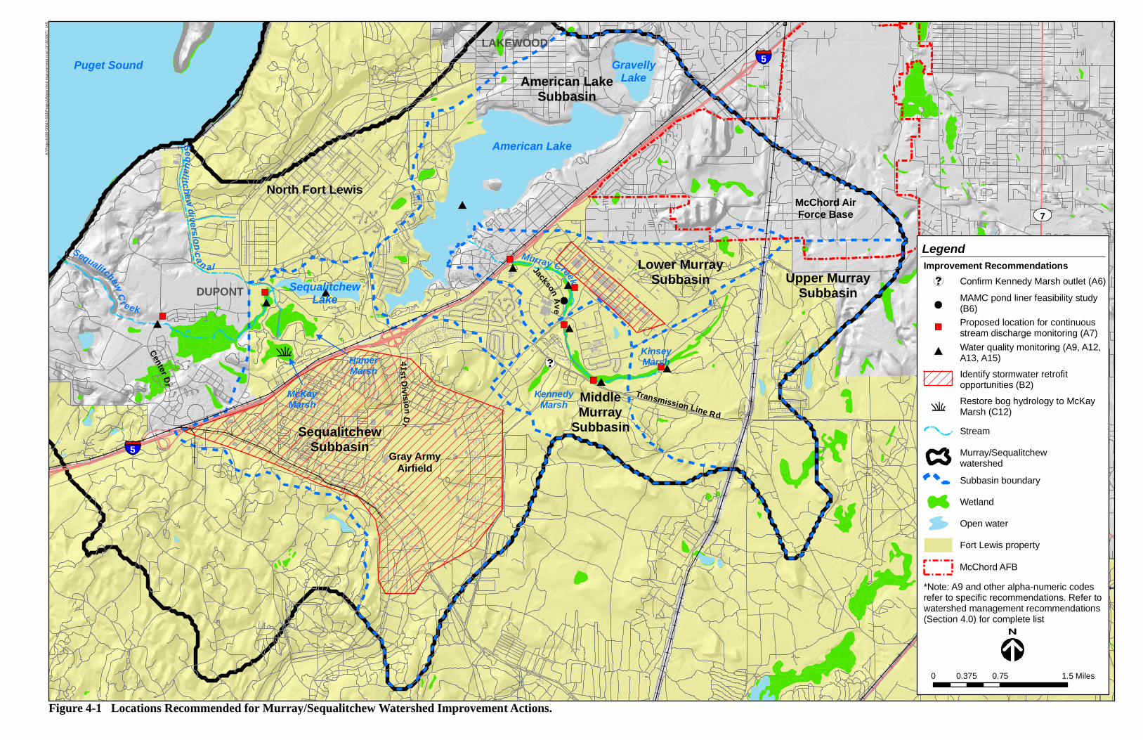
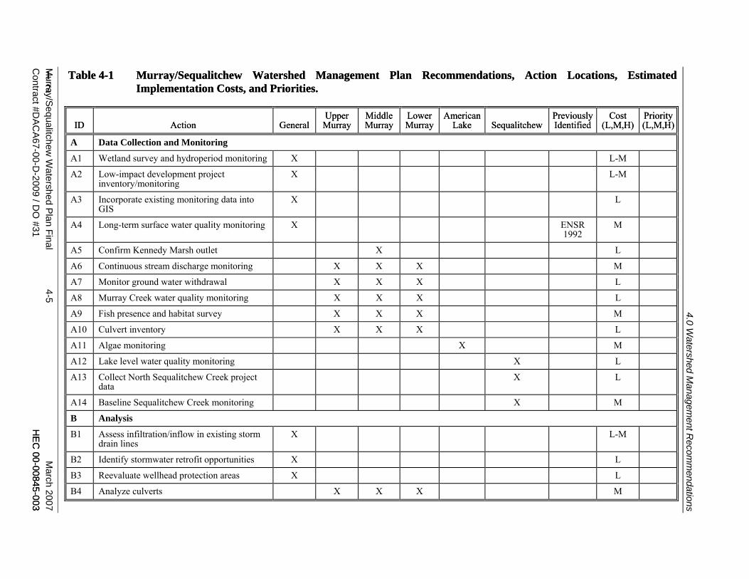
The watershed management recommendations are summarized in Table 4-1, which includes cost estimates and priorities for implementation. Each recommendation is identified by an alpha-numeric code for reference. These recommended watershed actions are also illustrated graphically on the accompanying map (Figure 4-1).
4.1 Data Collection and Monitoring Recommendations
4.1.1 General Recommendations for the Watershed
A1. Wetland survey and hydroperiod monitoring — Ensure that all wetlands located on Fort Lewis have been identified and delineated. Monitor water level fluctuation in Fort Lewis wetlands in relation to land and water use changes throughout the watershed. This information will provide a more complete database of water resources within Fort Lewis boundaries and will help to evaluate the effect of land use actions on wetland hydrology.
A2. Low-impact development project inventory/monitoring — Compile a database of existing low-impact development stormwater management pilot projects and incorporate this information into the Fort Lewis GIS system. The inventory should include information on location, best management practice (BMP) type, drainage area served, and drainage area description. In addition, conduct performance monitoring of projects to determine their effectiveness at infiltrating stormwater and reducing surface water discharge. This information will be used to help plan future projects.
A3. Incorporate existing monitoring data into GIS — Incorporate monitoring data into Fort Lewis GIS to provide a more convenient way for Fort Lewis personnel to access information for purposes of deconfliction and project planning.
A4. Long-term surface water quality monitoring — Establish a long-term watershed-wide surface water quality monitoring program to characterize how various portions of the watershed are influenced by local land use and stormwater discharge. Base flow and storm flow sampling locations and sampling parameters proposed by ENSR (1992) provide a good starting point for this program. This information will help Fort Lewis protect the beneficial uses of receiving waters, and identify existing or potential future water quality problems that may occur (see recommendation A8 for more specific water quality monitoring recommendations for Murray Creek).
March 2007 4-2 Murray/Sequalitchew Watershed Plan Final HEC 00-00845-003 Contract #DACA67-00-D-2009 / DO #31
5
5
American Lake
Puget Sound
41st Div ision D
r
GravellyLake
SequalitchewLake
Sequalitchew diversion ca n alSequalitchew C r eek
Murray Creek
KinseyMarsh
Center Dr
Jackson Ave
DUPONT
LAKEWOOD
7
North Fort Lewis
Transmission Line Rd
McChord AirForce Base
Gray ArmyAirfield
KennedyMarsh
HamerMarsh
McKayMarsh
American LakeSubbasin
Upper MurraySubbasin
Lower MurraySubbasin
SequalitchewSubbasin
MiddleMurray
Subbasin
Legend
Miles0 0.75 1.50.375
Figure 4-1 Locations Recommended for Murray/Sequalitchew Watershed Improvement Actions.
Murray/Sequalitchewwatershed
Stream
Subbasin boundary
Wetland
Fort Lewis property
Open water
K:\P
roje
cts\
00-0
0845
-003
\Pro
ject
\Wat
ersh
ed im
prov
emen
t.mxd
(3/1
9/20
07)
JAS
Improvement RecommendationsConfirm Kennedy Marsh outlet (A6)
MAMC pond liner feasibility study (B6)Proposed location for continuousstream discharge monitoring (A7)Water quality monitoring (A9, A12, A13, A15)
Identify stormwater retrofit opportunities (B2)
Restore bog hydrology to McKay Marsh (C12)
*Note: A9 and other alpha-numeric codes refer to specific recommendations. Refer towatershed management recommendations (Section 4.0) for complete list
McChord AFB

Murray/S
equalitchew W
atershed Plan Final 4-5 M
arch 2007C
ontract #DAC
A67-00-D
-2009 / DO
#31 HE
C 00-00845-003
1 2
HE
C 00-00845-003
Table 4-1 Murray/Sequalitchew Watershed Management Plan Recommendations, Action Locations, Estimated Implementation Costs, and Priorities.
Table 4-1 Murray/Sequalitchew Watershed Management Plan Recommendations, Action Locations, Estimated Implementation Costs, and Priorities.
ID ID Action Action General General Upper
Murray Upper
Murray Middle Murray Middle Murray
Lower Murray Lower Murray
American Lake
American Lake Sequalitchew Sequalitchew
Previously Identified Previously Identified
Cost (L,M,H)
Cost (L,M,H)
Priority(L,M,H)Priority(L,M,H)
1 2
A Data Collection and Monitoring
A1 Wetland survey and hydroperiod monitoring X L-M
A2 Low-impact development project inventory/monitoring
X L-M
A3 Incorporate existing monitoring data into GIS
X L
A4 Long-term surface water quality monitoring X ENSR 1992
M
A5 Confirm Kennedy Marsh outlet X L
A6 Continuous stream discharge monitoring X X X M
A7 Monitor ground water withdrawal X X X L
A8 Murray Creek water quality monitoring X X X L
A9 Fish presence and habitat survey X X X M
A10 Culvert inventory X X X L
A11 Algae monitoring X M
A12 Lake level water quality monitoring X L
A13 Collect North Sequalitchew Creek project data
X L
A14 Baseline Sequalitchew Creek monitoring X M
B Analysis
B1 Assess infiltration/inflow in existing storm drain lines
X L-M
B2 Identify stormwater retrofit opportunities X L
B3 Reevaluate wellhead protection areas X L
B4 Analyze culverts X X X M
4.0 Watershed M
anagement R
ecomm
endations
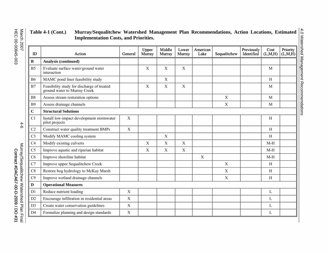
Table 4-1 (Cont.) Murray/Sequalitchew Watershed Management Plan Recommendations, Action Locations, Estimated
Implementation Costs, and Priorities.
March 2007 4-6 M
urray/Sequalitchew
Watershed P
lan FinalH
EC 00-00845-003 C
ontract #DA
CA67-00-D
-2009 / DO
#31 C
ontract #DA
CA67-00-D
-2009 / DO
#31
ID Action General Upper
Murray Middle Murray
Lower Murray
American Lake Sequalitchew
Previously Identified
Cost (L,M,H)
Priority(L,M,H)ID Action General
Upper Murray
Middle Murray
Lower Murray
American Lake Sequalitchew
Previously Identified
Cost (L,M,H)
Priority(L,M,H)
B Analysis (continued)
B5 Evaluate surface water/ground water interaction
X X X M
B6 MAMC pond liner feasibility study X H
B7 Feasibility study for discharge of treated ground water to Murray Creek
X X X M
B8 Assess stream restoration options X M
B9 Assess drainage channels X M
C Structural Solutions
C1 Install low-impact development stormwater pilot projects
X H
C2 Construct water quality treatment BMPs X H
C3 Modify MAMC cooling system X H
C4 Modify existing culverts X X X M-H
C5 Improve aquatic and riparian habitat X X X M-H
C6 Improve shoreline habitat X M-H
C7 Improve upper Sequalitchew Creek X H
C8 Restore bog hydrology to McKay Marsh X H
C9 Improve wetland drainage channels X H
D Operational Measures
D1 Reduce nutrient loading X L
D2 Encourage infiltration in residential areas X L
D3 Create water conservation guidelines X L
D4 Formalize planning and design standards X L
4.0 Watershed M
anagement R
ecomm
endations
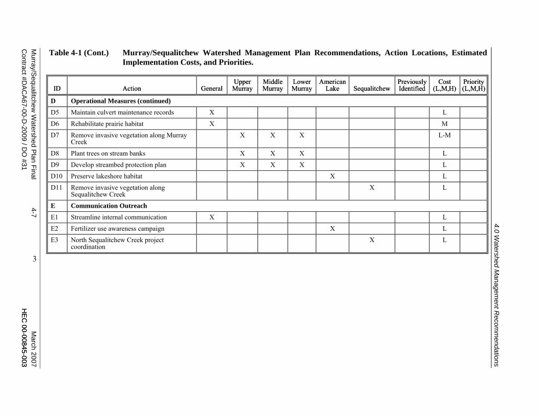
Table 4-1 (Cont.) Murray/Sequalitchew Watershed Management Plan Recommendations, Action Locations, Estimated
Implementation Costs, and Priorities.
Murray/S
equalitchew W
atershed Plan Final 4-7 M
arch 2007C
ontract #DAC
A67-00-D
-2009 / DO
#31 HE
C 00-00845-003
HE
C 00-00845-003
ID Action General Upper
Murray Middle Murray
Lower Murray
American Lake Sequalitchew
Previously Identified
Cost (L,M,H)
Priority(L,M,H)ID Action General
Upper Murray
Middle Murray
Lower Murray
American Lake Sequalitchew
Previously Identified
Cost (L,M,H)
Priority(L,M,H)
D Operational Measures (continued)
D5 Maintain culvert maintenance records X L
D6 Rehabilitate prairie habitat X M
D7 Remove invasive vegetation along Murray Creek
X X X L-M
D8 Plant trees on stream banks X X X L
D9 Develop streambed protection plan X X X L
D10 Preserve lakeshore habitat X L
D11 Remove invasive vegetation along Sequalitchew Creek
X L
E Communication Outreach
E1 Streamline internal communication X L
E2 Fertilizer use awareness campaign X L
E3 North Sequalitchew Creek project coordination
X L
4.0 Watershed M
anagement R
ecomm
endations
3
4.0 Watershed Management Recommendations
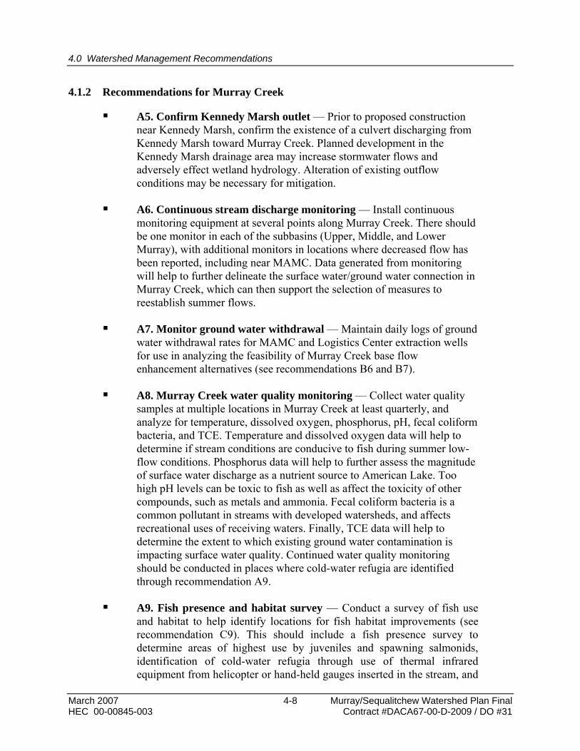
4.1.2 Recommendations for Murray Creek
A5. Confirm Kennedy Marsh outlet — Prior to proposed construction near Kennedy Marsh, confirm the existence of a culvert discharging from Kennedy Marsh toward Murray Creek. Planned development in the Kennedy Marsh drainage area may increase stormwater flows and adversely effect wetland hydrology. Alteration of existing outflow conditions may be necessary for mitigation.
A6. Continuous stream discharge monitoring — Install continuous monitoring equipment at several points along Murray Creek. There should be one monitor in each of the subbasins (Upper, Middle, and Lower Murray), with additional monitors in locations where decreased flow has been reported, including near MAMC. Data generated from monitoring will help to further delineate the surface water/ground water connection in Murray Creek, which can then support the selection of measures to reestablish summer flows.
A7. Monitor ground water withdrawal — Maintain daily logs of ground water withdrawal rates for MAMC and Logistics Center extraction wells for use in analyzing the feasibility of Murray Creek base flow enhancement alternatives (see recommendations B6 and B7).
A8. Murray Creek water quality monitoring — Collect water quality samples at multiple locations in Murray Creek at least quarterly, and analyze for temperature, dissolved oxygen, phosphorus, pH, fecal coliform bacteria, and TCE. Temperature and dissolved oxygen data will help to determine if stream conditions are conducive to fish during summer low-flow conditions. Phosphorus data will help to further assess the magnitude of surface water discharge as a nutrient source to American Lake. Too high pH levels can be toxic to fish as well as affect the toxicity of other compounds, such as metals and ammonia. Fecal coliform bacteria is a common pollutant in streams with developed watersheds, and affects recreational uses of receiving waters. Finally, TCE data will help to determine the extent to which existing ground water contamination is impacting surface water quality. Continued water quality monitoring should be conducted in places where cold-water refugia are identified through recommendation A9.
A9. Fish presence and habitat survey — Conduct a survey of fish use and habitat to help identify locations for fish habitat improvements (see recommendation C9). This should include a fish presence survey to determine areas of highest use by juveniles and spawning salmonids, identification of cold-water refugia through use of thermal infrared equipment from helicopter or hand-held gauges inserted in the stream, and
March 2007 4-8 Murray/Sequalitchew Watershed Plan Final HEC 00-00845-003 Contract #DACA67-00-D-2009 / DO #31
4.0 Watershed Management Recommendations
a stream habitat survey. The stream habitat survey could be conducted using the methods of McCain et al. (1990). Previous studies that have identified the losing and gaining reaches within the system can help to focus further investigations. The fate of gravel previously added for spawning in the stream should be investigated.
A10. Culvert inventory — Conduct a culvert inventory (invert elevation, condition) and integrate into the GIS database. Perched culverts, with a drop in elevation between the culvert and the downstream channel due to erosion of surrounding soils, or those clogged with sediment, indicate inappropriate grade lines (too steep or too flat). This information will be important in evaluating fish barriers and sedimentation problems (see recommendation B4) and prioritizing actions necessary to improve culvert functions while promoting aquatic habitat.
4.1.3 Recommendations for American Lake
A11. Algae monitoring — Monitor algal succession, and more specifically the timing and duration of cyanobacteria (blue-green algae) dominance, in American Lake. This information will provide a more complete understanding of the lake processes, and will help to assess the feasibility of using management techniques to reduce the dominance of potentially toxic strains of cyanobacteria.
4.1.4 Recommendations for Sequalitchew Lake
A12. Lake level water quality monitoring — Collect data to evaluate the effect of lake level management efforts on water quality. Proposed measures to improve flow rates in Sequalitchew Creek include raising the water level in Sequalitchew Lake. Raising the water level would result in a greater residence time for lake water, and could result in degraded water quality conditions. This monitoring should be started before lake level management measures are implemented to establish baseline conditions, and should continue for several years after. Potential water quality problems include increased temperature, reduced oxygen levels, and increased algae concentrations during summer months. (This also has implications for protecting Sequalitchew Springs as a drinking water source.)
4.1.5 Recommendations for Sequalitchew Creek
A13. Collect North Sequalitchew Creek project data — Coordinate with North Sequalitchew Creek project to obtain flow and channel survey data collected for that project. This information will help to support design
Murray/Sequalitchew Watershed Plan Final 4-9 March 2007 Contract #DACA67-00-D-2009 / DO #31 HEC 00-00845-003

4.0 Watershed Management Recommendations
of projects to improve water quality and habitat in upper Sequalitchew Creek.
A14. Baseline Sequalitchew Creek monitoring — Establish baseline hydrologic and water quality conditions in Sequalitchew Creek before Sequalitchew Lake level management measures and the North Sequalitchew Creek project are implemented so that effects of these projects can be evaluated.
4.2 Recommendations for Analysis
4.2.1 General Recommendations for the Watershed
B1. Assess infiltration/inflow in existing storm drain lines — Evaluate the degree to which ground water may infiltrate into deeper stormwater lines, increasing surface water discharge and dewatering shallow ground water. Infiltration of stormwater from existing pipes into ground water may be of concern if the ground water table is too close to the surface to allow removal of pollutants by the soil. This assessment will identify locations where existing storm drains should be repaired or replaced. If it is possible to completely retrofit the drainage basin upstream of a problem storm drain line with infiltration BMPs, the line may be abandoned in a way that will not allow ground water to continue to enter the pipe and discharge to surface waters (install pipe plug). If the storm drain systems are privatized, work with the new responsible parties to identify problem sections.
B2. Identify stormwater retrofit opportunities — Identify locations where the existing stormwater system can be retrofitted to increase infiltration, reduce surface discharge, and decrease pollutant concentrations (see recommendation C3 for implementation). Particular focus for retrofitting stormwater infiltration facilities should be on locations upstream of identified cold water fish refugia to both increase the volume infiltrated as well provide treatment prior to infiltration where required to protect water quality (see recommendation A9).
B3. Reevaluate wellhead protection areas — Review wellhead protection area documentation, and reevaluate delineations to ensure that they reflect the accurate ground water flow direction and the potential for lateral diffusion of contaminants. The current delineations, although revised within the past year, still appear unusually narrow.
March 2007 4-10 Murray/Sequalitchew Watershed Plan Final HEC 00-00845-003 Contract #DACA67-00-D-2009 / DO #31

4.0 Watershed Management Recommendations
4.2.2 Recommendations for Murray Creek
B4. Analyze culverts — Use information from culvert inventory (recommendation A10) to perform hydraulic analysis of culverts. If problems associated with capacity/flooding, fish passage, or sedimentation at existing Murray Creek culverts are identified, modify or replace the culverts to improve the condition in accordance with the criteria presented in the C4 recommendation.
B5. Evaluate surface water/ground water interaction — Expand on and update the work done by Shapiro (1996) to analyze the connection between ground water and surface water in Murray Creek. Determine surface aquifer water table elevation throughout the year, particularly at times of reduced base flow. Estimate seepage rates of surface water to ground water during low-flow conditions to help assess the feasibility of enhancing base flow (see recommendations B6 and B7).
B6. MAMC pond liner feasibility study — Evaluate the feasibility, cost, and benefit of installing an impermeable liner at the base of the MAMC cooling pond to increase surface water discharge to Murray Creek. The study will evaluate stream discharge monitoring data (see recommendation A6), surface water/ground water interaction (see recommendation B5), and MAMC extraction rates (see recommendation A8). The study must determine the impacts of discharge from the pond on temperature. See recommendation C6 for implementation.
B7. Feasibility study for discharge of treated ground water to Murray Creek — Expand on the work of ENSR (1998a) to evaluate the feasibility, cost, and benefit of installing a pipe and pump system to allow for discharge of treated ground water from the East Gate Disposal Yard and Interstate 5 systems to supplement Murray Creek base flow during the summer. The study will assess stream discharge monitoring data (see recommendation A7), surface water/ground water interaction evaluation (see recommendation B5), and ground water extraction rates (see recommendation A7). The study must determine the impacts of discharge from the pond on temperature and water chemistry in Murray Creek. See recommendation C7 for implementation.
4.2.3 Recommendations for American Lake
No recommendations.
Murray/Sequalitchew Watershed Plan Final 4-11 March 2007 Contract #DACA67-00-D-2009 / DO #31 HEC 00-00845-003
4.0 Watershed Management Recommendations
4.2.4 Recommendations for Sequalitchew Lake
No recommendations. Fort Lewis currently has a study planned for the lake.
4.2.5 Recommendations for Sequalitchew Creek
B8. Assess stream restoration options — Conduct a study of potential concepts for improving the morphology and hydrology of upper Sequalitchew Creek. The Directorate of Public Works plans to conduct this type of study in the near future.
B9. Assess drainage channels — Determine whether drainage channels running through wetlands near the Sequalitchew Creek headwaters are still required. If they were constructed to drain farm fields that are no longer used, then consider filling them to restore a more natural flow regime to the wetlands. This assessment may require coordination with drainage districts, Pierce County, or other agencies responsible for the channels.
4.3 Recommendations for Structural Solutions
4.3.1 General Recommendations for the Watershed
C1. Install low-impact development stormwater pilot projects and increase infiltration in existing system — Construct additional low-impact development pilot projects when opportunities arise on new development and redevelopment projects. These pilot projects should provide an opportunity to test the construction, operation and maintenance needs, and performance of new measures for increasing infiltration and reducing surface water discharge. See recommendation A2 for tracking and monitoring of low-impact development pilot projects. Retrofit the existing stormwater system to increase infiltration using low-impact development measures such as roof drain disconnects, drainage of paved surfaces to vegetated areas, and other measures.
C2. Construct water quality treatment BMPs — Retrofit the existing stormwater system to reduce pollutant levels where low-impact development measures are not feasible. Where substantial sources of nutrients to stormwater are identified, implement BMPs to reduce concentrations.
4.3.2 Recommendations for Murray Creek
C3. Modify MAMC cooling system — Modify the existing cooling system at MAMC so that it uses less water and ground water extraction
March 2007 4-12 Murray/Sequalitchew Watershed Plan Final HEC 00-00845-003 Contract #DACA67-00-D-2009 / DO #31
4.0 Watershed Management Recommendations
can be reduced. This modification may help increase base flows in Murray Creek and slow the migration of the Logistics Center TCE plume to the south.
C4. Modify existing culverts — If problems associated with capacity/flooding, fish passage, or sedimentation at existing Murray Creek culverts are confirmed through detailed analysis (see recommendation B4), modify or replace the culverts to improve the condition. The problem culverts should be ranked for replacement priorities and should be replaced with natural-bottom culverts or bridges where possible. Priority crossings may include those where improvements are most necessary to promote fish passage and access to habitat, or where work on the overlying roadway is planned for other reasons.
C5. Improve aquatic and riparian habitat — Introduce large woody debris and other habitat features at selected locations in Murray Creek (see recommendation A9 on cold water refugia). The woody debris and other cover are especially important as habitat for smaller fish. Enhance connectivity between riparian wetlands and the stream to provide additional spawning and rearing habitat for fish. Remove nonnative vegetation and revegetate with native plantings along streams and sensitive area. Replenish gravel for spawning if previous gravel has silted up.
4.3.3 Recommendations for American Lake
C6. Improve shoreline habitat — Construct shoreline habitat enhancements where possible, including bank stabilization, native vegetation establishment, and large woody debris placement. Focus enhancements near the Murray Creek outfall.
4.3.4 Recommendations for Sequalitchew Lake
No recommendations. Fort Lewis currently has a study planned for the lake that will focus on water supply issues, lake levels, and downstream flow in Sequalitchew Creek.
4.3.5 Recommendations for Sequalitchew Creek
C7. Improve upper Sequalitchew Creek — Restore stream processes and morphology (sinuosity, habitat complexity, sediment recruitment, etc.) to upper Sequalitchew Creek (see recommendation B8). The Directorate of Public Works plans to conduct a study that addresses this issue in the near future.
Murray/Sequalitchew Watershed Plan Final 4-13 March 2007 Contract #DACA67-00-D-2009 / DO #31 HEC 00-00845-003
4.0 Watershed Management Recommendations
C8. Restore bog hydrology to McKay Marsh — Reroute stormwater outfalls currently discharging to McKay Marsh to reduce water level fluctuation and nutrient enrichment to this historical bog system.
C9. Improve drainage channels — Based on the assessment results (recommendation B9), unnecessary drainage channels that adversely affect wetlands near the Sequalitchew Creek headwaters should be altered or eliminated to allow a more natural drainage pattern. This process may involve measures as simple as ceasing maintenance of these channels or constructing berms or other barriers to flow.
4.4 Recommendations for Operational Measures
4.4.1 General Recommendations for the Watershed
D1. Reduce nutrient loading — Collaborate with local jurisdictions and promote efforts outlined in the Sustainability Implementation Plan (U.S. Army 2005a) to reduce nonpoint nutrient loading that is characteristic of certain land uses, including residential and commercial uses. Better landscaping techniques, water conservation measures, and alternative household practices are some example recommendations.
D2. Encourage infiltration in residential areas — Coordinate with developers of residential areas and encourage the use of infiltration by retrofitting existing residential developments. (The family housing areas on the base are run by a private corporation, and Fort Lewis does not have direct control over their development.) Emphasize the cost savings of infiltration over piped stormwater systems.
D3. Formalize planning and design standards — Incorporate planning and design standards and procedures that are currently informally in place, (e.g., implementation of low-impact development practices, preserving open space and protecting trees) into a single document. Formal documentation of these procedures will improve the chances that the procedures will be implemented consistently regardless of the staff implementing the policies. In addition, formal documentation can help facilitate the deconfliction process by providing a consistent, predictable policy that is available for review by Fort Lewis personnel.
D4. Maintain culvert maintenance records — To support the evaluation of culverts (see recommendation B4), maintain a file of maintenance operations and site observations regarding flooding or sedimentation near culverts.
March 2007 4-14 Murray/Sequalitchew Watershed Plan Final HEC 00-00845-003 Contract #DACA67-00-D-2009 / DO #31
4.0 Watershed Management Recommendations
D5. Rehabilitate prairie habitat — Fort Lewis currently uses a stock of native prairie seed as a seed source when replanting open patches or newly disturbed upland areas within the installation. Where feasible, continue to restore prairie areas that have been encroached upon by trees since the establishment of the installation.
4.4.2 Recommendations for Murray Creek
D6. Remove invasive vegetation — Invasive, nonnative vegetation such as Himalayan blackberries should be removed from stream banks to encourage the establishment of native vegetation. Reed canarygrass should be removed when it is found along the stream. Invasive, nonnative vegetation can out-compete native plants, reducing habitat diversity and available food, and causing other problems such as stream bank erosion. Discourage new reed canarygrass growth through allelopathic compounds, such as mulch containing red cedar chips, and establishment of native plants that can shade out the reed canarygrass.
D7. Plant trees on stream banks — Although the riparian corridor appears to be in relatively good shape due to the 50-meter buffer, there are some stream reaches within the cantonment area (Middle Murray and Lower Murray subbasins) lacking adequate canopy cover. Plant native trees along open areas of stream to shade and moderate water temperature—especially in areas where they can help maintain coldwater refugia (see recommendation A9).
D8. Develop streambed protection plan — Develop procedures for minimizing streambed disturbance and avoiding increased permeability during construction requiring stream channel crossings. Options include reestablishing an impermeable layer of fine sediments in the streambed following construction or if natural siltation is inadequate to quickly replenish the lost sediment.
4.4.3 Recommendations for American Lake
D9. Preserve lakeshore habitat — Identify methods to preserve lakeshore habitat and work with other jurisdictions around American Lake to incorporate into appropriate planning and development documents.
4.4.4 Recommendations for Sequalitchew Lake
No recommendations. Fort Lewis currently has a study planned for the lake.
Murray/Sequalitchew Watershed Plan Final 4-15 March 2007 Contract #DACA67-00-D-2009 / DO #31 HEC 00-00845-003
4.0 Watershed Management Recommendations
4.4.5 Recommendations for Sequalitchew Creek
D10. Remove invasive vegetation — Invasive, nonnative vegetation such as reed canarygrass should be removed to encourage the establishment of native vegetation. Discourage new reed canarygrass growth through allelopathic compounds, such as mulch containing red cedar chips, and establishment of native plants that can shade out the reed canarygrass.
4.5 Recommendations for Communication Outreach
4.5.1 General Recommendations for the Watershed
E1. Streamline internal communication — Develop formal guidelines and procedures to integrate watershed protection efforts into land use actions in addition to the deconfliction process. These guidelines and procedures will bring additional continuity.
4.5.2 Recommendations for Murray Creek
No recommendations.
4.5.3 Recommendations for American Lake
E2. Fertilizer use awareness campaign — Coordinate with other municipalities and stakeholders in the American Lake subbasin on a public awareness campaign to reduce fertilizer use.
4.5.4 Recommendations for Sequalitchew Lake
No recommendations. Fort Lewis currently has a study planned for the lake.
4.5.5 Recommendations for Sequalitchew Creek
E3. North Sequalitchew Creek project coordination — A project such as the proposed North Sequalitchew Creek project will have major impacts on the flow regime of the creek’s main stem and likely will have repercussions for the operation of the Sequalitchew Lake outlet and diversion canal. Coordination between stakeholders is needed to help ensure that all the parts of the system are not operated at cross purposes.
March 2007 4-16 Murray/Sequalitchew Watershed Plan Final HEC 00-00845-003 Contract #DACA67-00-D-2009 / DO #31