3.0 watershed conditions - environmental protection...
TRANSCRIPT

3.0 Watershed Conditions
streams and lakes (surface freshwaters) within the Murray/Sequalitchew watershed are as follows:
Salmon and trout spawning Noncore-rearing and migration Primary contact recreation
The associated water quality standards for these designated uses are presented in Table 3.4-4.
Table 3.4-4 Water Quality Standards for Surface Waters of the State of Washington (Classified as Noncore-Rearing for Aquatic Life Uses and Primary Contact Recreation for Recreational Uses).
Parameter Standards
Temperature a Shall not exceed 17.5°C (63.5°F) Dissolved oxygen b Shall exceed 8.0 mg/L pH Shall be within the range of 6.5 to 8.5 Fecal coliform bacteria Geometric mean shall not exceed 100 colonies/100 mL, with no more than 10 percent
of all samples (or any single sample when less than 10 sample points exist) obtained for calculating the geometric mean exceeding 200 colonies/100 mL.
Turbidity Shall not exceed 5 NTU over background when the background is 50 NTU or less.
USEPA requires it not exceed 5 NTU over background when the background is 50 NTU or less.
Total phosphorus Shall not exceed 0.010 mg/L for oligotrophic lakes, and 0.020 mg/l for lower mesotrophic lakes in the Puget Lowlands of Nutrient Ecoregion II.
USEPA recommendation not to exceed 19.5µg/L to prevent excess algal growth in rivers and streams in the Puget Lowlands of Nutrient Ecoregion II.
Ammonia (total) Less than 19.7 mg/L assuming salmon are not present and typical values for temperature (15°C) and pH (7.0).
USEPA requires less than 2.1 mg/L assuming salmon are not present and typical values for temperature (15°C) and pH (7.0).
Acute Toxicity Standard c Chronic Toxicity Standard d Copper, dissolved μg/Le 8.9 μg/L at a hardness of 50 mg/L e, f 6.3 μg/L at a hardness of 50 mg/L f, g Lead, dissolved μg/Le 30.1 μg/L at a hardness of 50 mg/L e, f 1.2 μg/L at a hardness of 50 mg/L f, g Zinc, dissolved μg/Le 63.6 μg/L at a hardness of 50 mg/L e, f 58.1 μg/L at a hardness of 50 mg/L f, g
a 7-day average of the daily maximum temperatures. b A 24-hour minimum. c The acute toxicity standard is based on concentrations that are expected or demonstrated to result in injury or death to an
organism as a result of short-term exposure (WAC 173-201A-020). d The chronic toxicity standard is based on concentrations that are expected or demonstrated to result in injury or death to an
organism as a result of repeated or constant exposure over an extended period of time (WAC 173-201A-020). e A 1-hour average concentration not to be exceeded more than once every 3 years on average. f Criterion varies with water hardness. The acute and chronic toxicity criteria shown are based on a hardness value of 50.0 mg/L
as calcium carbonate. Samples with lower hardness values have lower criteria. g A 4-day average concentration not to be exceeded more than once every 3 years on average. °C = degrees Celsius. µg/L = micrograms per liter. mg/L = milligrams per liter. mL = milliliters. NTU = nephelometric turbidity units, the units used for measuring turbidity. Source: WAC 173-201A and USEPA (2000).
March 2007 3-40 Murray/Sequalitchew Watershed Plan Final HEC 00-00845-003 Contract #DACA67-00-D-2009 / DO #31
5
5
American Lake
Puget Sound
41st Div ision D
r
GravellyLake
SequalitchewLake
Sequalitchew diversion ca n alSequalitchew C r eek
KinseyMarsh
Center Dr
DUPONT
LAKEWOOD
7
North Fort Lewis
Transmission Line Rd
McChord AirForce Base
Gray ArmyAirfield
Bog
O02
O03
O07
O11
C01
C02C03
C04C05C06
C07C08
C09C10
Murr a y Creek
C11, C12, C13, C14
KennedyMarsh
HamerMarsh
McKayMarsh
American LakeSubbasin
Upper MurraySubbasin
Lower MurraySubbasin
SequalitchewSubbasin
MiddleMurray
Subbasin
Legend
Miles0 0.75 1.50.375
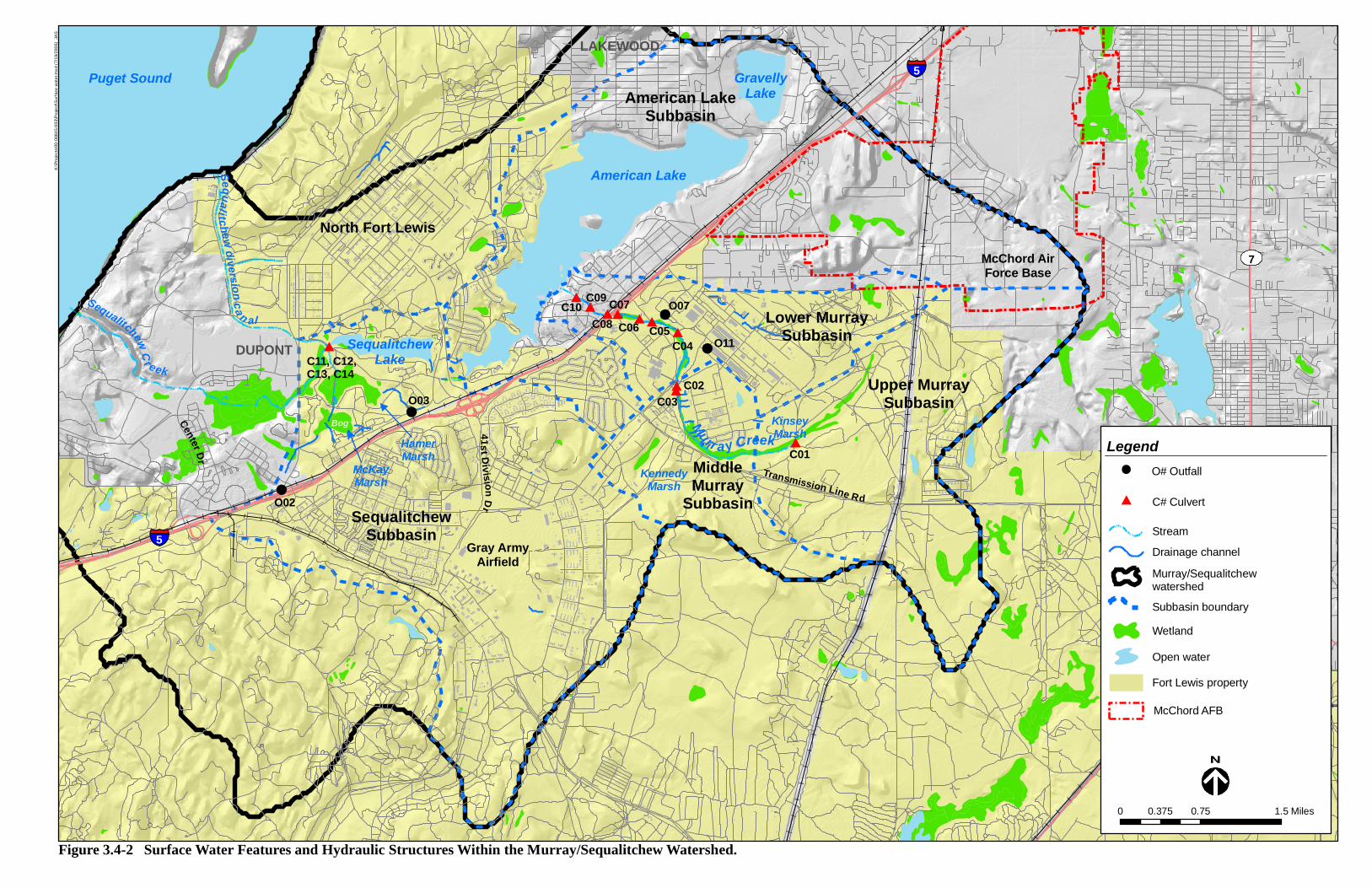
Figure 3.4-2 Surface Water Features and Hydraulic Structures Within the Murray/Sequalitchew Watershed.
Murray/Sequalitchewwatershed
Stream
Subbasin boundary
Wetland
Fort Lewis property
Drainage channel
Open water
K:\P
roje
cts\
00-0
0845
-003
\Pro
ject
\Sur
face
wat
er.m
xd (7
/19/
2006
) JA
S
C# Culvert
O# Outfall
McChord AFB

3.0 Watershed Conditions
Murray Creek
Fort Lewis personnel conducted inconclusive creek flow monitoring since the Shapiro (1996) study (Crown 2005c). Fort Lewis personnel have reported that the creek has gone dry in subsequent years, but flow monitoring data are not available to confirm the years in which this has occurred. As noted in the climate section of this plan, there was still flow in Murray Creek at the end of August 2005, despite precipitation that was approximately 20 percent below normal for the 2004 to 2005 water year. According to Fort Lewis personnel, flow has returned to the creek in the fall of each year that the creek has gone dry.
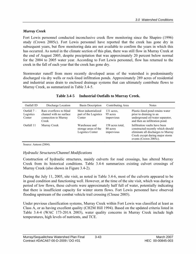
Stormwater runoff from more recently developed areas of the watershed is predominantly discharged via dry wells or rock-lined infiltration ponds. Approximately 289 acres of residential and industrial areas drain to enclosed drainage systems that can ultimately contribute flows to Murray Creek, as summarized in Table 3.4-5.
Table 3.4-5 Industrial Outfalls to Murray Creek.
Outfall ID Discharge Location Basin Description Contributing Area Notes
Outfall 7 – Logistics Center
Rare overflows to blind channel with no surface connection to Murray Creek
Most industrialized part of the Logistics Center
131 acres, 95 acres impervious
Plastic-lined pond retains water prior to draining to an underground oil/water separator, and then an infiltration pond.
Outfall 11 Murray Creek Warehouse and storage areas of the Logistics Center
158 acres total, 80 acres impervious
Infiltration vaults have been constructed recently which should eliminate all discharges to Murray Creek except during major storm events (Crown 2005c).
Source: Anteon (2004). Hydraulic Structures/Channel Modifications
Construction of hydraulic structures, mainly culverts for road crossings, has altered Murray Creek from its historical conditions. Table 3.4-6 summarizes existing culvert crossings of Murray Creek (also shown in Figure 3.4-2).
During the July 11, 2005, site visit, as noted in Table 3.4-6, most of the culverts appeared to be in good condition and functioning well. However, at the time of the site visit, which was during a period of low flows, these culverts were approximately half full of water, potentially indicating that there is insufficient capacity for winter storm flows. Fort Lewis personnel have observed flooding upstream of the combat vehicle trail crossing (Clouse 2005).
Under previous classification systems, Murray Creek within Fort Lewis was classified at least as Class A, or as having excellent quality (CH2M Hill 1994). Based on the updated criteria listed in Table 3.4-4 (WAC 173-201A 2003), water quality concerns in Murray Creek include high temperatures, high levels of nutrients, and TCE.
Murray/Sequalitchew Watershed Plan Final 3-43 March 2007 Contract #DACA67-00-D-2009 / DO #31 HEC 00-00845-003

3.0 Watershed Conditions
Table 3.4-6 Murray Creek Culvert Inventory.
Culvert ID Location Structure Type Size Material Notes
C01 Combat vehicle trail crossing
Three culverts 18-inch CMP a Approximately ½ full of fines and angular gravel at time of July 11, 2005, site visit. Fort Lewis personnel would like to replace with box culverts for fish passage.
C02 Downstream end of Middle Murray subbasin (tank trail crossing near MAMC)
Dual culverts 36-inch CMP Good condition, functioning well during July 11, 2005, site visit. However, culverts were flowing approximately ½ full during summer low flows. According to Fort Lewis personnel, there is occasional flooding upstream of these culverts.
C03 Downstream end of Middle Murray subbasin (Wilson Ave. crossing near MAMC)
Dual culverts 36-inch CMP Good condition, functioning well during July 11, 2005, site visit.
C04 Fillmore Street crossing
Culvert 48-inch CMP Beaver dam upstream at time of July 11, 2005, site visit. Culvert appeared to be in good condition and functioning well
C05 Jackson Ave. Dual culverts 36-inch CMP Not observed during July 11, 2005, site visit. No problems reported by Fort Lewis staff.
C06 Blaine Ave. crossing Dual culverts 36-inch RCP b Not observed during July 11, 2005, site visit. No problems reported by Fort Lewis staff.
C07 East side of Interstate 5
Three culverts 36-inch CMP Not observed during July 11, 2005, site visit. No problems reported by Fort Lewis staff.
C08 West side of Interstate 5
Three culverts 36-inch RCP Not observed during July 11, 2005, site visit. No problems reported by Fort Lewis staff.
C09 41st Division Way Three culverts 36-inch RCP Not observed during July 11, 2005, site visit. No problems reported by Fort Lewis staff.
C10 Armor Drive Three culverts 36-inch RCP Not observed during July 11, 2005, site visit. No problems reported by Fort Lewis staff.
a CMP = corrugated metal pipe. b RCP = reinforced concrete pipe. Source: Shapiro (1996) and July 11, 2005, site visit. The MAMC staff is currently conducting a study related to water supply for the hospital cooling system. The study is evaluating the possibility of using treated water for cooling, if temperature concerns can be addressed.
American Lake
No data are available for recent flows, lake levels, or water quality monitoring in American Lake. The annual algal toxicity testing by Pacific Lutheran University was discontinued in 1996. Previous studies from the mid-1990s, described earlier in this report, provide the best estimates of lake hydrology and water quality to date. However, based on previous data relating to winter algae blooms to anatoxin-a production, the Tacoma/Pierce County Health Department issued advisories closing the lake because of supposed toxic algae blooms whenever there was a bloom of anabaena. The most recent advisories were issued in the winters of 1997, 1998, 1999, 2000, and 2002 (Hanowell 2005). According to Ray Hanowell, a toxicologist from the Tacoma/Pierce
March 2007 3-44 Murray/Sequalitchew Watershed Plan Final HEC 00-00845-003 Contract #DACA67-00-D-2009 / DO #31

3.0 Watershed Conditions
County Health Department, there recently have been decreased frequencies of anabaena blooms, and no health advisories have been issued since 2002. Mr. Hanowell stated that there were no data to describe what could have reduced algal blooms in the lake and that no in-lake restoration efforts have been employed since the 1993 KCM study recommendations (Hanowell 2005).
Sequalitchew Lake
No data are available for recent flows, lake levels, or water quality monitoring in Sequalitchew Lake. Previous studies from the mid-1970s and early 1980s, described earlier in this report, provide the best estimates of water quality to date.
Sequalitchew Creek and the Diversion Canal
During a July 11, 2005, site visit, there was flow in both Sequalitchew Creek and the diversion canal. Four industrial stormwater outfalls ultimately contribute flow to the diversion canal. Two of these outfalls are located in the North Fort area, discharging to the diversion canal downstream of the study area (not shown on Figure 3.4-2). The other two outfalls are described in Table 3.4-7. Outfalls 02 and 03 discharge indirectly to the diversion canal, via Hamer Marsh or Bell Marsh. During the July 11, 2005, site visit, Fort Lewis staff expressed concerns about the effect of the outfalls on the marshes.
Table 3.4-7 Industrial Drainage Outfalls to Sequalitchew Diversion Canal.
Outfall ID Discharge Location Subbasin Contributing Area Notes
Outfall 02 – DuPont Gate
Bell Marsh to diversion canal
Sequalitchew 1,928 acres total 1,010 acres impervious
Outfall is at capacity; all new development discharging to this outfall must provide detention to restrict postdevelopment flow to predevelopment levels.
Outfall 03 – Flora Road
Hamer Marsh to diversion canal
Sequalitchew 1,675 acres total 617 acres impervious
No additional information available.
Sources: Anteon (2004), Crown (2005b), and July 11, 2005, site visit. Monthly surface water and ground water monitoring was conducted throughout the Sequalitchew subbasin downstream of Sequalitchew Lake for Glacier Northwest’s proposed North Sequalitchew Creek project (Aspect 2004). The study included a survey of Sequalitchew Creek and beaver dams were observed in each of the three culverts below the road between the Sequalitchew Lake outlet and the diversion canal weir during September and October 2004 (C11 in Table 3.4-8), along with a dam between the downstream end of the culverts and the diversion weir. The dams resulted in a Sequalitchew Lake water surface elevation of 1 to 1.5 feet higher than the diversion weir elevation. Fort Lewis personnel have been experimenting with various methods to discourage beaver activity, including wire mesh across the culvert openings.
Murray/Sequalitchew Watershed Plan Final 3-45 March 2007 Contract #DACA67-00-D-2009 / DO #31 HEC 00-00845-003

3.0 Watershed Conditions
Table 3.4-8 Sequalitchew Creek/Diversion Canal Culvert Inventory.
Culvert ID Location Structure Type Size Material Notes
C11 Sequalitchew Lake outlet Three culverts 4 feet high by 8 feet long
Reinforced concrete box culvert
Beaver dams observed in these culverts in fall 2004.
C12 Sequalitchew Creek crossing of canal
Four culverts 42 inch diameter
CMP a No additional information available.
C13 Diversion canal crossing of Sequalitchew Creek
Three culverts 48 inch diameter
CMP No additional information available.
C14 Sequalitchew Creek overflow
One culvert 18 inch diameter
CMP According to ENSR (1998a), this culvert is plugged with foam core, although small amount of flow through the culvert was observed during July 11, 2005, site visit.
a CMP = corrugated metal pipe. Sources: ENSR (1998a) and July 11, 2005, site visit. There is very limited recent water quality monitoring information available for Sequalitchew Creek. Previous studies from the mid-1970s and early 1980s, noted earlier in this report, provide the best estimates of water quality to date. Due to increased development within the subbasin, stormwater runoff has been suspected of contributing to water quality problems in Sequalitchew Creek. However, data are not available to affirm this supposition.
It was reported at the public meeting that the City of DuPont might have participated in a recent study of Sequalitchew Creek. The city reportedly ran out of funding and did not fully complete the project, but “boxes of data” were still lying around. After checking with various city officials, there is no evidence of such a study.
Anchor (2004a) evaluated the potential effects of introducing additional freshwater flow on the physical and biological conditions of the small brackish marsh at the mouth of Sequalitchew Creek. This study was intended to identify the potential impacts of increased freshwater flow to this marsh from the proposed North Sequalitchew Creek channel as part of the Glacier Northwest facility expansion. Twenty salinity measurement locations were identified and monitored on 2 days, April 14 and April 19, 2004. Seven stations were located along the Sequalitchew Creek channel, with the uppermost stations serving as background locations for freshwater conditions. The study concluded that the additional flow of the proposed North Sequalitchew Creek channel would only minimally decrease the salinity in the marsh.
3.4.3 Primary Surface Water Data Sources and Data Gaps Surface Water Data Sources
Information on surface water quantity of the study area was obtained primarily from the following sources:
March 2007 3-46 Murray/Sequalitchew Watershed Plan Final HEC 00-00845-003 Contract #DACA67-00-D-2009 / DO #31
3.0 Watershed Conditions
Shapiro (1996) – An Assessment of Murray Creek in Pierce County, Washington. Summary report with appendices
Pierce County (1997) – Chambers-Clover Creek Watershed Management Committee, Watershed Characterization
Shapiro (1997a) – Lake-Level Management Plan for Sequalitchew Lake
Shapiro (1997b) – Murray Creek Planning Guide
ENSR (1998a) – Final Sequalitchew Lake Level Management Plan Environmental Assessment
ENSR (1998b) – Feasibility of Alternatives for Restoring Baseflow to Murray Creek, Fort Lewis, Washington
Surface Water Data Gaps Flow and Water Quality Monitoring Data on Murray Creek
Fort Lewis has not conducted any ongoing flow monitoring of Murray Creek since 1996, but has received recommendations to do so in the Murray Creek Planning Guide (Shapiro 1997b). In the absence of permanent monitoring stations in the creek, the effectiveness of any actions taken to address loss of base flow in Murray Creek or the impacts of land use changes, such as increasing infiltration through reductions in effective impervious area, cannot be quantified.
The Final Integrated Natural Resources Management Plan produced by ENSR (2000) referenced an ongoing surface water quality monitoring program planned by Fort Lewis. According to this study, surface water quality would be regularly monitored at 30 locations within Fort Lewis, including one river, five streams, and 13 lakes or marshes. However, Fort Lewis personnel have reported that this monitoring program has not been implemented (Crown 2005c).
Hydraulic Connectivity of Kennedy Marsh
Based on conversations with Fort personnel, there may be a culvert connecting Kennedy Marsh to Murray Creek. The marsh is located southwest of Murray Creek on the south side of Transmission Line Road in the Middle Murray subbasin. It is important to confirm whether there is a surface water connection between these two features, particularly since there is proposed development in the vicinity of Kennedy Marsh.
Creek Profile and Cross Sections for Sequalitchew Creek and Diversion Canal
A previous study investigated options for managing the water level in Sequalitchew Lake to protect the installation’s potable water source at the adjacent springs (Shapiro 1997a). There is a proposed study related to protection of the springs, scheduled to begin in fall of 2006. The prior study focused on relatively minor modifications, such as adjusting weir elevation levels and
Murray/Sequalitchew Watershed Plan Final 3-47 March 2007 Contract #DACA67-00-D-2009 / DO #31 HEC 00-00845-003

3.0 Watershed Conditions
installing sensors and alarms at the backflow prevention weir. Elevation data for Sequalitchew Creek and the diversion canal would provide Fort Lewis personnel with information needed to determine whether limited re-grading of the creek or channel modifications could improve creek habitat and reduce backwater into the lake.
Creek Profile for Murray Creek
Fort Lewis personnel have noted significant maintenance needs associated with culverts along Murray Creek. Creek profile information in the vicinity of existing culverts would help to identify some of the causes of sediment deposition, and upstream channel modifications may help to address the source of these sediments.
Ground Water Quality Monitoring for American Lake
The KCM (1993) study recommended additional ground water monitoring to track the effectiveness of watershed nutrient control measures in improving the water quality of American Lake. Another recommendation of the study was to include nutrient analyses in the ongoing site remediation monitoring studies occurring within the American Lake drainage basin.
The Woodward-Clyde (1996) study identified several data gaps in studies of the American Lake drainage basin. Data gaps pertaining to surface water quality include the following:
Insufficient monitoring data to allow for an adequate assessment of background levels of phosphate concentrations
Inadequate monitoring of several stormwater outfalls around the lake
Inadequate assessment of the flow rates in Murray Creek
Stormwater Quality and Flow Monitoring of Sequalitchew Creek
Discharge of stormwater from developed areas in the Sequalitchew subbasin has reportedly led to decreased water quality. Regular storm flow and base flow water quality monitoring is necessary to support this supposition.
3.4.4 Ongoing Studies and Research
Three highly relevant ongoing studies related to surface water quantity are discussed below.
Madigan Army Medical Center (MAMC)
The MAMC staff is conducting a study related to water supply for the hospital cooling system, which began in October 2004 and is anticipated to be completed in 2006. The MAMC is supplied with ground water through five wells, one of which is a potable water well at a depth of 250 feet. The remaining four wells provide cooling water for the chillers, and supply water for the surface water feature at the hospital. In addition to the base flow loss observed in Murray Creek, MAMC staff have observed decreased pumping capacity from the wells and are
March 2007 3-48 Murray/Sequalitchew Watershed Plan Final HEC 00-00845-003 Contract #DACA67-00-D-2009 / DO #31

3.0 Watershed Conditions
concerned about water quality impacts associated with the TCE plume. The study has investigated the decreased capacity from the hospital’s pumping wells, and is evaluating the possibility of using treated water for cooling, if temperature concerns can be addressed.
Sequalitchew Springs
A study is in progress to develop alternatives for restoring or enhancing flow within Sequalitchew Creek, protecting Sequalitchew Creek, and reducing the flow diverted to the diversion canal. The Sequalitchew Springs Source Water Protection Project, being conducted by AHBL, Incorporated, includes site reconnaissance, review of existing data, a longitudinal survey of the thalweg (the line defining the lowest points of the channel) and cross-sections of Sequalitchew Creek, and flow monitoring. The study could include development of a hydraulic model to evaluate the impacts of alternatives for restoring streamflow in Sequalitchew Creek on flow rates and water surface elevations.
North Sequalitchew Creek
There are several previous and ongoing studies related to the North Sequalitchew Creek project associated with the proposed Glacier Northwest facility expansion. While much of the monitoring has been conducted in areas outside Fort Lewis, the Army should continue to be apprised of water quality, flow, and survey data collected through this project.
3.4.5 Previous Study Recommendations Water Quality Monitoring
Various studies have made recommendations pertaining to flow and water quality monitoring within Murray and Sequalitchew creeks, and water quality monitoring of American and Sequalitchew lakes (WDSHS 1981; ENSR 1992; Shapiro 1997a). The ENSR (1992) study suggested parameters and monitoring locations for base flow and stormwater sampling. Fort Lewis has not conducted monitoring in response to these recommendations (Crown 2005c).
Watershed Management Measures
The report produced for the Phase I American Lake restoration project recommended a series of watershed management measures to control both external and internal sources of nutrients, which are linked to toxic algae bloom problems. Alum treatment was recommended to provide a short-term reduction of internal phosphorus loading (KCM 1993). Other recommended watershed control measures included implementing public awareness programs (landscaping techniques, water conservation measures, better septic system maintenance and sewer upgrades, drainage controls, and alternative household practices), developing a landscape management plan for the Tacoma Country and Golf Club, and implementing the best management practices outlined in a study of the Clover/Chambers Creek Basin (WDSHS 1981) on the federal property, to be consistent with local and state regulations.
Murray/Sequalitchew Watershed Plan Final 3-49 March 2007 Contract #DACA67-00-D-2009 / DO #31 HEC 00-00845-003
3.0 Watershed Conditions
Improving Salmon Habitat within Sequalitchew Creek
As part of the salmon habitat limiting factors analysis for the Chambers-Clover Creek watershed, the Washington State Conservation Commission made several broad action recommendations for ways in which Fort Lewis and other nearby jurisdictions could collaborate to improve water quality conditions within Sequalitchew Creek (Runge et al. 2003). These recommendations include the following:
Take necessary actions to maintain perennial base flow, which is directly related to improved water quality conditions.
Reduce stormwater runoff and other inputs of urban pollution into the drainage.
Implement BMPs to reduce nonpoint source nutrient contributions to the streams and lakes in the upper watershed.
Identify sources of fecal coliform bacteria contamination and take necessary actions to eliminate them.
Planning Recommendations
The Murray Creek Planning Guide (Shapiro 1997b) made the following recommendations:
Limit increased impervious surface areas by implementing strategies such as grass swales, vertical parking structures, and narrower road widths.
Infiltrate stormwater.
Implement clearing and grading BMPs.
Preserve forested open space, and provide a stream buffer.
Implement planning guidelines for recharge protection areas and ground water protection areas.
Based on conversations with Fort Lewis personnel, many of these recommendations have been implemented.
Protecting Sequalitchew Springs
Shapiro (1996) recommended that several measures be taken to protect Sequalitchew Springs from potentially contaminated lake water:
March 2007 3-50 Murray/Sequalitchew Watershed Plan Final HEC 00-00845-003 Contract #DACA67-00-D-2009 / DO #31

3.0 Watershed Conditions
Increase elevation of backflow prevention weir to approximately 212.87 feet to increase vertical separation between Sequalitchew Lake and the springs.
Install an alarm and lake level monitoring system.
Monitor lake levels and beaver activity.
Maintain hydraulic control structures (remove sediment from culverts when depth is greater than 20 percent of the culvert diameter).
Evaluate the need for improvements to the lake outlet diversion weir.
As noted previously, a study related to protection of Sequalitchew Springs is pending and scheduled to begin as early as fall of 2006.
3.4.6 Key Surface Water Issues
As a topic of concern to the public and stakeholders throughout the watershed, it is in the interest of Fort Lewis to monitor and improve streamflow, habitat, and water quantity and quality throughout the Murray/Sequalitchew watershed, focusing on the following key issues:
Protection of the Fort Lewis potable water supply, including Sequalitchew Springs
Protection of the Fort Lewis storm drainage infrastructure, including culverts, storm drains, and infiltration systems, from flooding, beaver activity, and other maintenance concerns
Protection of water quality and habitat in American Lake, Sequalitchew Lake, Sequalitchew Creek, and Murray Creek to promote biological and recreational uses
3.4.7 Potential Solutions for Surface Water
To protect the Fort Lewis water supply, the following measures may be taken:
Evaluate options for increasing base flow in Murray Creek by reducing ground water use. Options may include reducing ground water pumping for the MAMC cooling system and ponds by evaluating the feasibility of recirculation, an alternate cooling system, or lining the cooling ponds.
Make protection of Sequalitchew Springs a high priority. Implement the proposed study related to protection of the springs in the near future.
Murray/Sequalitchew Watershed Plan Final 3-51 March 2007 Contract #DACA67-00-D-2009 / DO #31 HEC 00-00845-003

3.0 Watershed Conditions
Implement water conservation measures and track water consumption.
To protect the Fort Lewis storm drainage infrastructure, the following measures may be taken:
Conduct a culvert inventory assessing the condition, streamflow, invert elevation (i.e., elevation of the inside bottom of the pipe), diameter, and creek condition in the vicinity of the culvert.
Conduct hydraulic analyses for culverts that appear to have insufficient flow conveyance capacity. Any culvert analyses should also incorporate a fish passage evaluation.
Assess the condition of existing storm drains when possible, for example if they are exposed during construction.
Identify locations for storm drain network retrofits to increase stormwater infiltration.
To protect and enhance water quality and flow in Murray and Sequalitchew creeks, as well as in American and Sequalitchew lakes, the following measures could be taken:
Implement a comprehensive, long-term surface water quality monitoring program in order to better understand the sources and magnitudes of pollutant loading, and to determine where and when water quality conditions are degraded and in need of improvement to support ecosystem and anthropogenic uses. The monitoring results should be incorporated into the installation’s GIS database for easier access by Army personnel for use in deconfliction and project planning.
Implement a comprehensive, long-term surface water quantity monitoring program in order to better understand the perennial and seasonal differences in stream base flow and to identify locations and frequencies of base flow loss during the dry season. This streamflow information can support calculations of pollutant loading based on water quality monitoring information and on the relationship between infiltration and base flow rates.
Implement nutrient reduction BMPs in the American Lake drainage basin.
Identify opportunities for infiltration of stormwater runoff from developed areas.
Look for opportunities to coordinate with neighboring communities, especially on Sequalitchew Creek issues. At the September 7, 2005, public
March 2007 3-52 Murray/Sequalitchew Watershed Plan Final HEC 00-00845-003 Contract #DACA67-00-D-2009 / DO #31

3.0 Watershed Conditions
meeting, the Nisqually Tribe, in particular, expressed an interest in being involved.
Monitor algal succession in American Lake, particularly with emphasis on the timing and duration of blue-green algae dominance. This information will provide a more complete understanding of the lake processes, and will help to assess the feasibility of using management techniques to reduce the dominance of potentially toxic strains of algae.
Collect data to evaluate the effect of lake level management efforts on lake water quality. Proposed measures to improve flow rates in Sequalitchew Creek include raising the water level in Sequalitchew Lake, which would result in a greater residence time for lake water, and could result in degraded water quality conditions. Monitoring should be started before lake level management measures are implemented to establish baseline conditions and should continue for several years. Potential water quality problems include increased temperature, reduced oxygen levels, and increased algae concentrations during the summer months. Lake level management has implications for protecting Sequalitchew Springs as a drinking water source.
3.5 Ground Water Quantity and Quality
3.5.1 Historical Ground Water Conditions
Hydrogeology
Surface and ground water in the Fort Lewis area are closely linked because of the permeable soils and high ground water table. Regional ground water recharge for the aquifers underlying the Murray/Sequalitchew watershed begins when precipitation falls on the western flank of the Cascade Mountains and travels westward mainly through aquifers ultimately discharging to Puget Sound. The Murray/Sequalitchew watershed is underlain by a stratified geologic formation that is composed of multiple alternating aquifers and aquitards (layers of low permeability impeding vertical ground water flow). The upper unconfined aquifer, which is sometimes referred to as the surface or shallow aquifer, is composed of the following geologic layers, listed in descending order from the surface: Steilacoom gravels, Vashon recessional outwash, Discovery nonglacial unit, and Narrows glacial drift. Deeper aquifers in the study area include the sea level, minus 300-foot, and minus 800-foot aquifers (Shapiro 1996).
The upper portion of the layered aquifer system (the surface and sea level aquifers) described above extends from Puget Sound east to approximately 2,000 to 4,000 feet inland, where a single unconfined aquifer (Sequalitchew delta aquifer) consisting of Steilacoom gravels is present. The surface aquifer water table quickly drops more than 150 feet to approximately sea level at the interface between the layered aquifer system and the Sequalitchew delta aquifer (Woodward-Clyde 1990).
Murray/Sequalitchew Watershed Plan Final 3-53 March 2007 Contract #DACA67-00-D-2009 / DO #31 HEC 00-00845-003

3.0 Watershed Conditions
Throughout most of the project area, depth to the water table in the shallow unconfined upper aquifer typically ranges between 10 and 30 feet, with shallower depths near surface water features (CH2M Hill 1994). Seasonal fluctuation of the water table generally ranges between 2 and 6 feet. Ground water in this area generally travels horizontally in a western direction at an average rate of 4.4 feet per day toward Puget Sound (Pierce County 1997). Hydrostatic ground water levels decrease with aquifer depth, indicating a downward vertical gradient. Vertical velocities in the shallow upper unconfined aquifer have been estimated at 0.06 to 1.1 feet per day, and velocities in the deeper sea level aquifer have been estimated at 0.4 to 4.0 feet per day (Woodward-Clyde 1990). A vertical connection between the surface aquifer and the sea level aquifer in the vicinity of the Logistics Center is evident based on the extent of a plume of contaminants.
Shallow ground water in the Upper, Middle and Lower Murray Creek subbasins generally travels to the northwest from Kinsey Marsh toward American Lake, which is a surface exposure of the surface aquifer (Shapiro 1996). Ground water in the Sequalitchew subbasin follows a similar pattern, flowing to the northwest to Sequalitchew Lake, another exposure of the local water table. Ground water inflow to Sequalitchew Lake is estimated at up to 150,000 cubic feet per day before exiting the lake to the west and north (AGI 1993, 1996).
Shallow ground water (surface aquifer) in the Sequalitchew subbasin travels generally west to northwest at a rate of 20 to 400 feet per year. Deeper ground water flow in the sea level aquifer is estimated to travel westerly at a rate of 150 to 1,500 feet per year. The horizontal hydraulic gradient of the surface aquifer in the Sequalitchew subbasin is estimated at 0.0005 to 0.005 ft/ft, and the gradient in the Sequalitchew delta aquifer is estimated at 0.002 ft/ft. Near the interface between the two aquifers, the horizontal hydraulic gradient was calculated at 0.06 to 0.13 ft/ft. The steeper the gradient (i.e., the larger the number) the faster the ground water travels. Greater values are possible where the aquifers make contact with each other (Woodward-Clyde 1990).
The stream channel in the Upper Murray subbasin (including Kinsey Marsh) was identified as a perennially gaining reach, meaning that it receives base flow from shallow ground water year-round. Portions of the stream channel in the Middle Murray subbasin were identified as perennially gaining and mixed, meaning the channel alternately loses base flow to ground water and receives base flow from ground water at different times of the year. The stream channel in the Lower Murray subbasin was identified as a perennially losing reach, and has been observed to occasionally go dry during the summer low-flow period (Shapiro 1996).
Ground Water Quality
Ground water in the Fort Lewis area is generally low in total dissolved solids, with a predominance of calcium and bicarbonate as major constituents (ENSR 2000).
Ground water quality in the regional surface aquifer that extends underneath the Murray/Sequalitchew watershed has been degraded in urbanizing portions of Pierce County. A study conducted by WDSHS (1987) documented increases in nitrates, chlorides, and bacteria that are believed to be associated with urban development. Samples from densely urbanized portions
March 2007 3-54 Murray/Sequalitchew Watershed Plan Final HEC 00-00845-003 Contract #DACA67-00-D-2009 / DO #31

3.0 Watershed Conditions
of Pierce County, located north of Fort Lewis and the study area, appear to have higher pollutant concentrations than those from Fort Lewis.
The Tacoma-Pierce County Health Department (TPCHD) petitioned the USEPA to designate the surface aquifer in the Clover/Chambers Creek basin (including the Murray/Sequalitchew watershed) as a sole-source aquifer in 1987. In 1993, the USEPA approved this designation, which provides limited water quality protection (ENSR 1998a).
A study of phosphorus sources to American Lake was conducted beginning in 1995 by Woodward-Clyde (1997b). The average background concentration of soluble reactive phosphorus (SRP) measured in wells located up-gradient of MAMC and the Logistics Center (in the vicinity of the Kinsey Marsh in the Upper Murray subbasin) was 24 μg/L. The average SRP concentration measured in wells located in the Logistics Center (Middle Murray subbasin) was 32 μg/L, and the average measured in wells located in Tillicum (Lower Murray subbasin) was 45 μg/L. The study concluded that these average SRP values were within the range of natural background phosphorus levels. The primary sources of human-related phosphorus in ground water are septic systems and stormwater drywells (Woodward-Clyde 1997b). However, elevated SRP levels detected in wells located in Tillicum (within 0.5 miles of American Lake) could not be directly attributed to these sources. The spatial variability in SRP concentrations in the Tillicum wells appears to be related to depths of well screens rather than proximity to septic systems, dry wells, or other human sources. Fecal coliform bacteria data illustrated little correlation with SRP concentrations. Because the monitoring results were not able to distinguish human sources of phosphorus, such as septic systems, stormwater drywells, and fertilizer use, from natural phosphorus, it was assumed that the contributions from human sources were small relative to background phosphorus levels (Woodward-Clyde 1997b).
Minor contamination of soil and ground water has been noted in connection with underground storage tanks and landfill areas within Fort Lewis, but the greatest impact on ground water quality in the Murray Creek watershed is a contaminant plume originating at the Logistics Center (Engineering and Environment et al. 2004; Bussey 2005). At the East Gate Disposal Yard (EGDY) adjacent to Kinsey Marsh, historical disposal of waste chemicals including TCE, trichloroethane (TCA), perchloroethylene (PCE), vinyl chloride (VC), petroleum, oils, and lubricants has led to contamination of the surface and sea level aquifers. TCE has been identified as the major contaminant in the ground water plume, which extends northwest in the surface aquifer toward American Lake. TCE has been detected at concentrations up to 250,000 μg/L in the surface aquifer and up to 180 μg/L in the sea level aquifer. Some of the pollutant source material (nonaqueous phase liquid [NAPL]) was removed from the EGDY through drum removal, but some was left in place. The surface aquifer contaminant plume extends northwest approximately 13,000 feet from the EGDY, with a width of approximately 4,000 feet. The TCE plume is centered approximately 400 feet up gradient of South I Street, and extends northwest and west approximately 4,800 feet downgradient (USACE 2002).
Only one known water supply well screened in the surface aquifer is located within the current contaminant plume. This well, called the Beachcomber Complex well, is located in Tillicum, just south of American Lake. No volatile organic compounds (VOCs) were detected when this well
Murray/Sequalitchew Watershed Plan Final 3-55 March 2007 Contract #DACA67-00-D-2009 / DO #31 HEC 00-00845-003

3.0 Watershed Conditions
was sampled in 2002. Two water supply wells used by MAMC (wells MAMC 3 and 4) currently draw water from the sea level aquifer within the boundaries of the contaminant plume; they are still in operation in spite of the TCE plume because the water is not typically used for drinking. TCE has been detected in well MAMC 3 at levels up to 2.7 μg/L. No contaminants have been detected in samples collected from well MAMC 4, which could be used as a backup drinking water source. Two water supply wells (#13 and #16), located near MAMC and in the northwest corner of the Logistics Center, respectively, are screened in the sea level aquifer, and were shut down because of potential TCE contamination (USACE 2002; Crown 2005b).
Two ground water extraction/treatment (pump-and-treat) facilities consisting of well fields, treatment plants, and recharge systems were constructed to contain the TCE plume, remove contaminants from the collected ground water, and re-infiltrate the treated water. These facilities, located at the EGDY and along the northwest end of the Logistics Center east of the Interstate 5 system, began operation in 1995 (USACE 2002). In addition to extracting and treating contaminated ground water, in-situ thermal remediation of the source material is being conducted at EGDY where ground water TCE concentrations exceed 1,000 μg/L (Bussey 2005).
3.5.2 Existing Ground Water Conditions Hydrogeology
It is not expected that the overall ground water flow patterns discussed in the Historical Ground Water Conditions section above have changed substantially since they were documented. Ground water-surface water interaction within the Murray Creek channel, however, may vary seasonally and between years.
Fort Lewis collects a majority of its drinking water from Sequalitchew Springs at the east end of Sequalitchew Lake, and is dependent on ground water for the remainder of its water supply. With eight additional active water supply wells, the water supply system has a capacity of approximately 13,200 gallons per minute or 19 million gallons per day (mgd), and a storage capacity of 4,800 gallons per minute (6.9 mgd). Wellhead protection areas have been established for the potable water supply wells and Sequalitchew Springs based on 6-month and 10-year time of travel zones in ground water. Figure 3.5-1 displays the ground water withdrawal locations and associated wellhead protection areas.
Table 3.5-1 displays information regarding ground water withdrawal within the Murray/Sequalitchew watershed.
In the Middle Murray subbasin, cooling water for MAMC is collected primarily from the surface aquifer using five extraction wells (wells MAMC 3 and 4 extract from the sea level aquifer), some of which is infiltrated back into the surface aquifer through two infiltration ponds. Some of the extracted water (up to 100 gallons per minute) is diverted for irrigation uses. Pumping rates range from 500 to 1,200 gallons per minute (averaging 1,100 to 1,200 gallons per minute) in the winter to 1,500 to 2,500 gallons per minute in the summer.
March 2007 3-56 Murray/Sequalitchew Watershed Plan Final HEC 00-00845-003 Contract #DACA67-00-D-2009 / DO #31

5
5
American Lake
Puget Sound GravellyLake
SequalitchewLake
Sequalitchew diversion ca n alSequalitchew C r eek
Murray Creek
KinseyMarsh
DUPONT
LAKEWOOD
North Fort Lewis
SequalitchewSprings
Wells #19a, 19bWell #12a, 12b
Well #17
Well #6
Well #14Well #20
EGDY wellfield
Well #8
I-5 wellfield
Well #16
McChord AirForce Base
Gray ArmyAirfield
American LakeSubbasin
Upper MurraySubbasin
Lower MurraySubbasin
SequalitchewSubbasin Middle
MurraySubbasin
Legend
Miles0 0.75 1.50.375
Figure 3.5-1 Ground Water Withdrawal Locations and Associated Wellhead Protection Areas in the Murray/Sequalitchew Watershed.
Murray/Sequalitchewwatershed
Stream
Subbasin boundary
Fort Lewis property
Open water
Wellhead protection areas
Ground water withdrawallocations
Middle MurraySubbasin
AmericanLake
Subbasin
Lower MurraySubbasin
5
Murray Creek
Well #13
MAMC 4
MAMC 3
MAMC 5MAMC 6
MAMC 1
MAMC 2MAMC 7
Area Enlarged
K:\P
roje
cts\
00-0
0845
-003
\Pro
ject
\Gro
undw
ater
With
draw
l.mxd
(3/1
9/20
07)
JAS
MAMC
EGDY
Madigan Army Medical Complex
East Gate Disposal Yard
McChord AFB
6-month protection area
1-year protection area
5-year protection area
10-year protection area


3.0 Watershed Conditions
Table 3.5-1 Ground Water Withdrawal Locations within the Study Area.
Location Subbasin
Approximate Withdrawal Rate
(gallons per minute) Status Use
Sequalitchew Springs Sequalitchew 9,600 Active Potable water supply Well #6 Sequalitchew 400 Active Potable water supply Well #8 Middle Murray 800 Active Potable water supply Well #12A Sequalitchew 1,400 Active Potable water supply Well #12B Sequalitchew 1,300 Active Potable water supply Well #13 Middle Murray 950 Active Potable water supply Well #14 Sequalitchew 1,000 Active Potable water supply Well #16 Lower Murray 1,000 Out of service due to
potential contamination Potable water supply
Well #17 Sequalitchew 500 Active Potable water supply Well #19A Sequalitchew 275 Out of service due to
low capacity Potable water supply
Well #19B Sequalitchew 450 Out of service due to low capacity
Potable water supply
Well #20 Sequalitchew 1,650 Active Potable water supply MAMC 1 Middle Murray 1,500 Active Cooling water MAMC 2 Middle Murray 200 Not in service Not developed MAMC 3 Middle Murray 360 Active Cooling water MAMC 4 Middle Murray 750 Active Emergency potable
supply MAMC 5 Middle Murray 400 Not in service Not developed MAMC 6 Middle Murray 1,230 Active Cooling water MAMC 7 Middle Murray 1,340 Active Cooling water LC – EGDY well field Upper Murray 800 Active Pump and treat
ground water remediation system
LC – Interstate 5 well field
Lower Murray 2,000 Active Pump and treat ground water remediation system
MAMC = Madigan Army Medical Center. LC = Logistics Center. EGDY = East Gate Disposal Yard. Sources: ENSR (1998b), USACE (2002), Bussey (2005), and Crown (2005a). The EGDY pump-and-treat system is designed to pump at a rate of 800 gallons per minute, and the Interstate 5 system is designed to pump at a rate of 2,000 gallons per minute (USACE 2002). Pumping well fields are located less than 500 feet northwest of Kinsey Marsh at the EGDY in the Upper Murray subbasin, and less than 500 feet northeast of Murray Creek (Interstate 5 system) in the Lower Murray subbasin.
Murray/Sequalitchew Watershed Plan Final 3-59 March 2007 Contract #DACA67-00-D-2009 / DO #31 HEC 00-00845-003