3.0 existing conditions
TRANSCRIPT

York Region | Road Crossing of Highway 404 between Elgin Mills Road and 19th Ave Class Environmental Assessment Study
MMM Group Limited | September 2015 |
3-1
3.0 EXISTING CONDITIONS
3.1 SOCIO-ECONOMIC ENVIRONMENT
The Study Area is bounded by Elgin Mills Road on the south, 19th Avenue to the north, Leslie Street to the
west and Woodbine Avenue / Woodbine Bypass to the east. The Study Area is shown in Exhibit 1-1.
3.1.1 Existing and Future Land Uses
City of Markham
East of Highway 404, lands are under the jurisdiction of the City of Markham. Existing land uses per City
of Markham Official Plan, 2013 (see Exhibit 3-1) illustrates that the land uses included a mix of retained
Greenbelt, residential development and commercial development to the east of Woodbine Avenue. Between
Woodbine Bypass and Woodbine Avenue, lands are part of the Cathedral Town subdivision and consist
largely of detached residential houses. Residential development from Elgin Mills Road to approximately
600 m north of Elgin Mills Road is part of the Cathedral Community Planning District. To the west of
Woodbine Bypass (i.e. northeast quadrant of Highway 404 and Elgin Mills Road), lands are currently vacant
but are designated for future business development.
From approximately 600 m north of Elgin Mills Road, lands are within the Highway 404 North Planning District.
Lands between Woodbine Bypass and Woodbine Avenue are residential use (i.e. continuation of the
Cathedral Community). Besides this area, the remaining lands within the Highway 404 North Planning District
are designated for Business Park / Employment uses. Existing employment uses include the Honda Canada
campus (office and training facility) and Enbridge Gas (office and training facility). A warehouse facility in the
northwest quadrant of Woodbine Bypass / Honda Boulevard is being constructed and will be occupied by
Mobis, a division of Hyundai. Lands immediately south of 19th Avenue include industrial uses (an industrial
yard/operation just east of Highway 404), Fletcher’s Field (a rugby stadium), farming uses, as well as utilities
such as Hydro One corridor and Trans Canada Pipeline station. Other remaining lands with the Highway 404
North Planning District are currently vacant but will be developed in the future for business/employment uses.
The existing development and active development that are being reviewed / approved within the Highway 404
North Planning District became one of the key constraints in the EA Study when identifying suitable location
for the proposed road crossing.
Areas immediately east of Woodbine Avenue (i.e. east of the study area of the EA Study) are being planned
for future urban uses. In the December 9, 2014 City of Markham Development Services Committee Report,
staff provided an update on the “Future Urban Area – Conceptual Master Plan Process” (i.e. lands bounded
by Major Mackenzie Drive to the south, Woodbine Avenue / Hydro Corridor to the west, northerly City Limit /
Elgin Mills Road to the north and Robinson Creek to the east) (see Exhibit 3-2). As urban development
continues north of Elgin Mills Road, the plan for additional east-west linkages to support anticipated growth is
York Region | Road Crossing of Highway 404 between Elgin Mills Road and 19th Ave Class Environmental Assessment Study
MMM Group Limited | September 2015 |
3-2
being considered. Various transportation network scenarios will be developed and analyzed based on the
proposed land use identified in the Future Urban Area.
Town of Richmond Hill
West of Highway 404, lands are under the jurisdiction of the Town of Richmond Hill. In the northeast
quadrant of Elgin Mills Road and Leslie Street intersection, there are large stores uses such as Home
Depot, and Costco, as well as restaurants and medical buildings. Access to this development is from
Leslie Street and Elgin Mills Road, as well as from a local road – John Birchall Road (approximately
300 m east of Leslie Street and extend northerly from Elgin Mills Road).
The York Centre (a mental health services facility for children and families in York Region) is located at
11225 Leslie Street (approximately half way between 19th Avenue and Elgin Mills), on the east side of
Leslie Street.
Otherwise, lands in the Study Area within the Town of Richmond Hill are largely rural with some farming
operation. Future land uses are shown in the North Leslie Secondary Plan (Town of Richmond Hill Official
Plan 2010, As Partially Approved By Order of the Ontario Municipal Board July 4, 2014) which illustrates that
the land uses include a mix of retained natural heritage system, residential development and commercial
development in addition to the Richmond Green recreational facility and secondary school that also serves
residents in Markham (see Exhibit 3-3). Parts of this area are difficult to access and service with respect to
infrastructure due to the abundance of natural features associated with the Rouge River.
There are multiple active residential development applications for the North Leslie Secondary Plan that are
within the study area of the Class EA Study. The future residential subdivisions would include low and
medium density development (i.e. detached homes and townhouses). A draft Master Environmental
Servicing Plan (i.e. the assessment and planning in areas such as natural environment, cultural environment,
drainage, geotechnical, hydrogeology, noise, urban design guideline, etc.) has been prepared as part of the
development process and is currently being reviewed by relevant technical agencies including the Town of
Richmond Hill. As part of the EA Study, the Project Team met with relevant property owners and technical
agencies about progress of the North Leslie Secondary Plan in order to find a best balanced solution
between the proposed road crossing over Highway 404 and the future development in this Secondary Plan
area. Information in the draft Master Environmental Servicing Plan was reviewed by specialists on the
Project Team of the Class EA Study; relevant information has been taken into consideration in the respective
specialty areas.

York Region | Road Crossing of Highway 404 between Elgin Mills Road and 19th Ave Class Environmental Assessment Study
MMM Group Limited | September 2015 |
3-3
Exhibit 3-1: City of Markham Land Use – Official Plan Map 3 Land Use
Source: City of Markham Official Plan 2014 (Map 3 – Land Use)

York Region | Road Crossing of Highway 404 between Elgin Mills Road and 19th Ave Class Environmental Assessment Study
MMM Group Limited | September 2015 |
3-4
Exhibit 3-2: City of Markham Land use (Future Urban Area)
Source: City of Markham Development Services Committee Report – December 9, 2014
Exhibit 3-3: Town of Richmond Hill, North Leslie Secondary Plan Land Use
Source: Town of Richmond Hill Official Plan 2010, As Partially Approved By Order of the Ontario Municipal
Board July 4, 2014 (Schedule A)

York Region | Road Crossing of Highway 404 between Elgin Mills Road and 19th Ave Class Environmental Assessment Study
MMM Group Limited | September 2015 |
3-5
3.2 TRANSPORTATION
3.2.1 Existing Road Network
The existing road network in the Study Area consists of the following:
Elgin Mills Road – under the jurisdiction of York Region with up to 36 m right-of-way within the
Study Area (east of Woodbine Avenue, Elgin Mills Road is under the jurisdiction of the City of
Markham). Elgin Mills is a 4-lane urban road between Woodbine Bypass and Leslie Street. East
of Woodbine Bypass, Elgin Mills Road narrows to a 2-lane urban road. The roadway is illuminated
with a posted speed of 60 km/h. There are sidewalks on Elgin Mills Road through the residential
subdivision east of Woodbine Bypass. There is an interchange with Highway 404 on Elgin Mills
Road.
19th Avenue – under the jurisdiction of the City of Markham (east of Highway 404) and the Town
of Richmond Hill (west of Highway 404) with a 20-25 m right-of-way. 19th Avenue is a 2-lane rural
road with intermittent rural residential properties with direct access to the roadway. The roadway is
not illuminated with a posted speed of 60 km/h. There are no sidewalks on 19th Avenue.
19th Avenue crosses over Highway 404. A future interchange with Highway 404 is identified in the
York Region Transportation Master Plan (2009) although not yet a Regional road and still requiring
the start of an EA Study.
Woodbine Bypass – under the jurisdiction of York Region with up to 36 m right-of-way.
Woodbine Bypass is a 4-lane urban road from Major Mackenzie Drive and connects to Woodbine
Avenue approximately 1 km south of 19th Avenue. The roadway is illuminated with a posted speed
of 70 km/h. There are sidewalks on both sides of the roadway.
Woodbine Avenue – under the jurisdiction of the City of Markham with 24.5 m right-of-way
between Major Mackenzie Drive and approximately 1 km south of 19th Avenue, where Woodbine
Avenue connects with Woodbine Bypass; it is a parallel north-south facility to Woodbine Bypass.
Through this section of Woodbine Avenue, it is a 2-lane semi urban/rural road with on-street bike
lane on the east side (rural side) and sidewalk on the west side (urban side). The posted speed is
50 km/h. There are intermittent rural residential properties with direct access to Woodbine Avenue
on the east side, and on the west side are residential houses that are part of the Cathedral
Community with no direct access to Woodbine Avenue. There is no illumination through this
section of Woodbine Avenue. Approximately 1 km south of 19th Avenue, Woodbine Avenue
connects with Woodbine Bypass and continues northerly as Woodbine Avenue. This section of
Woodbine Avenue is a 2-lane rural road with no sidewalks but is illuminated. The posted speed is
80 km/h.
Leslie Street – under the jurisdiction of York Region with up to 43 m right-of-way. It is a 2-lane
rural road, except immediately north of Elgin Mills Road where it is a 4-lane urban road. A
sidewalk is provided on the east side where the road is urban (i.e. north of Elgin Mills Road),
York Region | Road Crossing of Highway 404 between Elgin Mills Road and 19th Ave Class Environmental Assessment Study
MMM Group Limited | September 2015 |
3-6
otherwise, there are no sidewalks on the road. There are intermittent rural residential property and
field accesses from Leslie Street. The roadway is not illuminated with a posted speed of 60 km/h.
3.2.2 Future Road Network
Planned improvements in the transportation network in the study area include the widening of Leslie Street
to 4 lanes, extension of Honda Boulevard to 19th Avenue and the 19th Avenue interchange with
Highway 404. Each will require EA studies prior to construction.
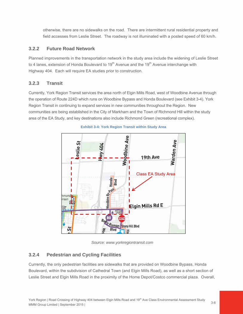
3.2.3 Transit
Currently, York Region Transit services the area north of Elgin Mills Road, west of Woodbine Avenue through
the operation of Route 224D which runs on Woodbine Bypass and Honda Boulevard (see Exhibit 3-4). York
Region Transit in continuing to expand services in new communities throughout the Region. New
communities are being established in the City of Markham and the Town of Richmond Hill within the study
area of the EA Study, and key destinations also include Richmond Green (recreational complex).
Exhibit 3-4: York Region Transit within Study Area
Class EA Study Area
Source: www.yorkregiontransit.com
3.2.4 Pedestrian and Cycling Facilities
Currently, the only pedestrian facilities are sidewalks that are provided on Woodbine Bypass, Honda
Boulevard, within the subdivision of Cathedral Town (and Elgin Mills Road), as well as a short section of
Leslie Street and Elgin Mills Road in the proximity of the Home Depot/Costco commercial plaza. Overall,
York Region | Road Crossing of Highway 404 between Elgin Mills Road and 19th Ave Class Environmental Assessment Study
MMM Group Limited | September 2015 |
3-7
there are limited pedestrian or cycling facilities on Elgin Mills Road, 19th Avenue, Woodbine Avenue and
Leslie Street.
York Region, the City of Markham and the Town of Richmond Hill are promoting the use of active
transportation through the planning and implementation of pedestrian and cycling facilities throughout the
Region. Within the study area, sidewalks are being proposed on both sides on Elgin Mills Road (a portion
of which has already been implemented as described in this section), and bike lanes are proposed on 19th
Avenue and Woodbine Avenue / Woodbine Bypass as part of the York Region Pedestrian and Trail Master
Plan (2008). City of Markham’s Pathways and Trails Master Plan (2009) also identified road cycling routes
on Woodbine Bypass and also within the local road network of the Highway 404 North Planning District,
such as Honda Boulevard and other future roads. In addition, Town of Richmond Hill’s Pedestrian and
Cycling Master Plan (2010) identified proposed bike lane on the proposed crossing of Highway 404 north
of Elgin Mills Road.
3.3 NATURAL ENVIRONMENT
As part of the Highway 404 road crossing between Elgin Mills Road East and 19th Avenue Class EA Study,
the ecological implications of the proposed roadway were assessed. The first stage of this assessment
involved recording and documenting existing fish and fish habitat and terrestrial conditions, as
documented within Section 3.3 of the Environmental Study Report (ESR). This assessment incorporated a
comprehensive review of background information and multi-year (2013 to 2015) field studies. As outlined,
there were, however, several ‘Permission To Enter’ (PTE) restrictions that limited some of the field data
collection to a certain extent.
The background information encompassed database sources and agency input, as well as several existing
studies. Key among them were the thorough Master Environmental Servicing Plan (MESP) for North
Leslie Secondary Plan Area completed by The Municipal Infrastructure Group Ltd. (TMIG), Phase 1
(March 2012) and by Cole Engineering Group Ltd. (CEG) Phase 2 (August 2014). These studies include
the collection of natural environment field survey information within the Town of Richmond Hill, which
include the lands west of Highway 404 to Bayview Avenue, and south of 19th Avenue to Elgin Mills Road
East. At the time of preparation of this ESR, the final approval of the MESP is still pending.
Relevant portions of these natural environmental survey findings have been used as the primary source of
information for this Class EA, as requested by the reviewing agencies. Information was extracted from
these studies to cover the current study areas, between Highway 404 and Leslie Street and 19th Avenue to
Elgin Mills Road East. The above-noted PTE limitations meant that not all of the lands within the overall
study area were granted PTE during the three-year window of field study. At the time of preparation of this
ESR, the final approval of the MESP is still pending. Therefore, there are some elements that may still be
refined that could have specific implications on some of the recommendations.

York Region | Road Crossing of Highway 404 between Elgin Mills Road and 19th Ave Class Environmental Assessment Study
MMM Group Limited | September 2015 |
3-8
As defined in Section 1.1, the study area includes land within both the Town of Richmond Hill and the City
of Markham. Specific details about survey type and location (dependent on PTE) are described in
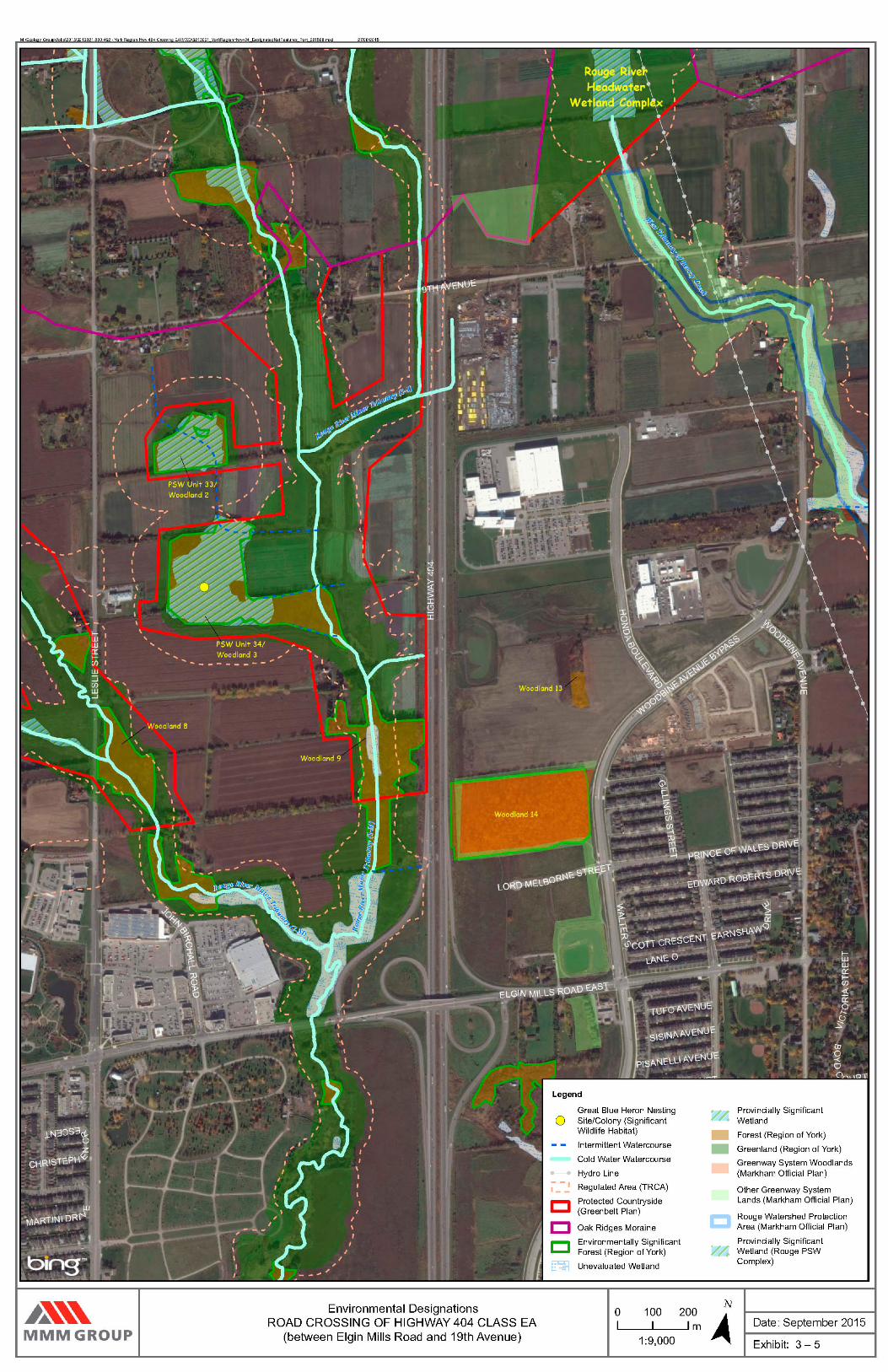
Section 3.3.1. Existing environmental designation areas are shown on Exhibit 3-5.
This information collected through review of background resources and field surveys was then used to
assess the potential impacts of the proposed improvements and develop preliminary mitigation
recommendations to minimize those impacts.
3.3.1 Review of Background Information and Field Review
Background information sources were reviewed to develop an understanding of the general character of the
natural features in the study area, identify potential constraints and sensitivities, and assess the general
connectivity of natural features in the study limits to features within the surrounding landscape. As noted,
the sources available in this case provided a solid understanding given the comprehensiveness of the
studies undertaken recently that encompassed this study area.
Background natural environment information collection included the following sources:
Topographic mapping and Google satellite mapping;
Liaison with the Aurora District Ministry of Natural Resources and Forestry (MNRF) and Toronto and Region Conservation Authority (TRCA) staff to gather and confirm existing natural environment information in the vicinity of the study area, including information concerning Species At Risk (SAR) presence / potential;
MNRF’s Natural Heritage Information Centre (NHIC) database;
Department of Fisheries and Oceans (DFO) SAR habitat mapping;
North Leslie Secondary Plan Area: MESP Phase 1 (The Municipal Infrastructure Group Ltd.; March, 2012), specifically Section 2: Natural Environment and Appendix A: Natural Environment and Natural Heritage System (Beacon Environmental Ltd.);
North Leslie Secondary Plan Area: MESP Phase 2 (Cole Engineering Group Ltd.; August, 2014), specifically Chapter 3: Environmental Study (Beacon Environmental Ltd.);
OPA 149 – Highway 404 North Secondary Plan Area (Cunningham Environmental Associates & SCS Consulting Group Ltd.; April, 2008 (Revised December 2010));
Aquatic Survey Approach
Aquatic surveys were conducted by MMM within the study area, as property access permitted, on June 13,
2013, December 2, 2014, June 24, 2015, and July 3, 2015. As outlined, the compiled background
information, and most particularly information detailed from the MESP (TMIG 2012), provided the basis for
the field surveys. As listed in Section 3.3.6, Species At Risk (SAR) information was obtained from a variety
of background information sources including personal communication with agency staff, MESP Phases 1 &
2 Reports, DFO’s Distribution of Fish SAR Mapping and the NHIC database.

York Region | Road Crossing of Highway 404 between Elgin Mills Road and 19th Ave Class Environmental Assessment Study
MMM Group Limited | September 2015 |
3-9
Field data collection focused on the stream reaches crossed by the alternative road alignments, with
general assessment up and downstream again subject to PTE, to provide context. Fish community
sampling was not undertaken as permission from the MNRF was not granted due to the presence of
sensitive aquatic species.
Habitat surveys were conducted within the road alignments of the alterative road right-of-way crossings, as
well as approximately 50 m to 100 m upstream and downstream of the crossings, where access was
permitted. Information collected encompassed the following aquatic habitat parameters:
Aquatic habitat mapping;
Channel dimensions, general gradient and profile, bank character (e.g. height and erosion);
General flow characteristics (permanent, intermittent, dry, pooling) including evidence of groundwater discharge;
General morphology (flats, pools, riffles);
Substrates;
Instream / overhead cover opportunities (e.g. woody debris, undercut banks, boulders, vegetation);
Riparian vegetation;
Physical barriers to fish movement;
Identification of potential critical or specialized habitat areas or features (e.g. potential spawning areas, nursery cover);
Observations of habitat alterations / land use (e.g. channel modification, potential pollutant point sources);
Potential habitat enhancement opportunities.
All crossings assessed were documented and photographs were taken. Refer to Appendix C for site
photographs; additional representative photographs are on file with MMM.
Vegetation Survey Approach
Vegetation surveys were conducted by MMM within the study area, as property access was permitted, on
June 13, 2013, July 10, 2014, and June 26, 2015. These surveys documented the characteristics of the
natural and culturally influenced vegetation communities occurring within the study area, with a focus on the
natural features along and adjacent to the alternative road alignments. Street trees and planted landscape
features were not assessed by the ecologists specifically during these field visits, but will be addressed by
the project landscape architects during detail design.
Vegetation field work and associated data assessment involved:
Preparing a working vascular plant species list;

York Region | Road Crossing of Highway 404 between Elgin Mills Road and 19th Ave Class Environmental Assessment Study
MMM Group Limited | September 2015 |
3-10
Classifying and mapping vegetation communities according to the Ecological Land Classification (ELC) System for Southern Ontario (Lee et. al., 1998). Where previous ELC mapping was documented by others, that information was reviewed and updated where property access was permitted (e.g., TMIG 2012, CEG 2015, Cunningham Environmental Associates 2010);
Evaluating the sensitivity and significance of vegetation species and vegetation communities using the MNRF’s NHIC database and SAR websites (updated periodically), the TRCA L Ranks (TRCA 2003 and TRCA 2010), the York Region rare species list from The Distribution and Status of the Vascular Plants of the Greater Toronto Area (Varga et al. 2000), and the Natural Heritage Resources of Ontario: Vegetation Communities of Southern Ontario (Bakowsky 1996);
Evaluating habitat potential for vegetation Species of Conservation Concern (SCC), and in particular, SAR known or thought to exist in the general vicinity of the study area; and
Noting general vegetation characteristics including age, general habitat features, drainage conditions, as well as any anthropogenic disturbance.
All terrestrial natural areas with landowner permission to access were documented and photographs were
taken. Refer to Appendix C for site photograph; additional representative photographs are on file with
MMM.
Wildlife Survey Approach
Wildlife surveys were conducted by MMM within the study area, as property access permitted, on June 13,
2013, June 17, 2015, and July 5, 2015. In 2013, property access was only available for portions of the
study area west of Highway 404; for the June 17, 2015 survey, property access was only available for the
southern edge of Wildlife Survey Unit (WSU) 1/ Woodlot 2 and WSU 4; and for the July 5, 2015 survey,
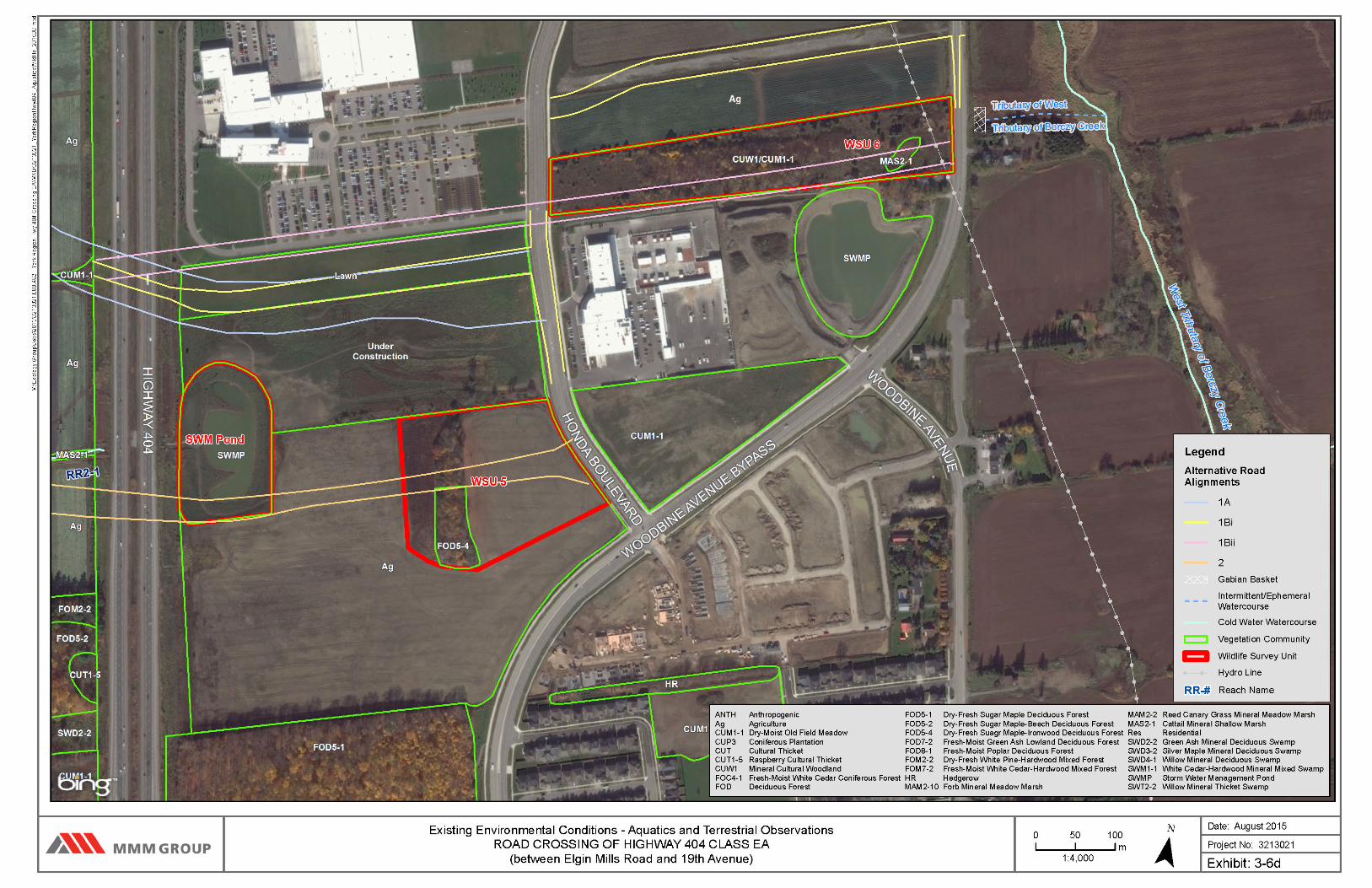
additional property access was granted for WSU 5, 6 and the SWM Pond. Targeted, species specific
surveys were not undertaken; however, Ecologists are trained to look for wildlife in appropriate habitats. All
wildlife sightings and wildlife signs, including browse, track / trails, scat, nests, burrows, tree cavities,
excavated holes and vocalizations were recorded during the field investigations, and habitat conditions
documented. Although PTE was limited both overall and to specific periods for field visits, field surveys of all
natural features within or adjacent to the proposed crossing locations were undertaken at least once. For
areas with no PTE on individual survey dates, surveys were completed from the nearest road.
An initial survey was conducted on June 13, 2013 to assess general wildlife and breeding birds and confirm
and/or update findings from the Phase 1 MESP (TMIG 2012). General wildlife surveys were completed in
combination with breeding bird surveys on June 17, 2015 and July 5, 2015.
Wildlife habitat features west of Highway 404 include: Woodlands 2 and 3 (WSU 1 and 2), and the riparian
corridor along Major Tributary 1-M (WSU 3 and 4); these features are part of the Rouge PSW Complex and
Greenbelt NHS. East of Highway 404, the wildlife habitat features are comprised of: the SWM Pond; a
small isolated patch of forest surrounded by agricultural fields and an active construction zone (WSU 5); a

York Region | Road Crossing of Highway 404 between Elgin Mills Road and 19th Ave Class Environmental Assessment Study
MMM Group Limited | September 2015 |
3-11
patch with a mixture of re-generating thicket, forest and cattail marsh (WSU 6); and a 10 m wide hedgerow
adjacent to the Honda facility (WSU 7).
Breeding bird surveys were undertaken by qualified, experienced staff, using protocols established in the
Ontario Breeding Bird Atlas (OBBA) (Cadman et.al. 2007; Bird Studies Canada 2001). The breeding bird
surveys were completed during appropriate weather conditions (low wind, no precipitation) and timing (two
visits during the breeding bird season, beginning at dawn). The study area was thoroughly surveyed using
wandering transects through or at the perimeter of features, with frequent listening / observation stops at
appropriate locations. All avifauna species and their abundance, location and level of breeding evidence
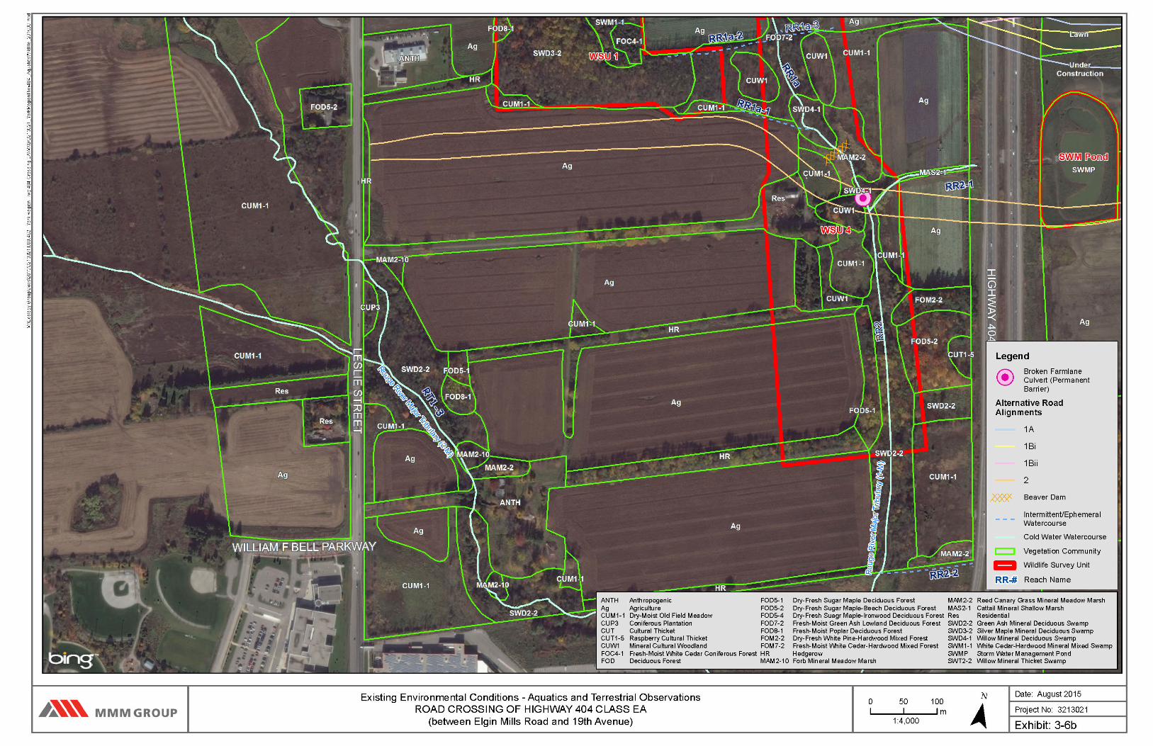
were recorded. Locations of species were noted according to Wildlife Survey Units (WSU 1-7 and SWM
Pond; see Exhibits 3-6a to 3-6e).
Wildlife field investigations also included assessing the various habitats present in relation to their potential
to support Species At Risk (SAR) and/or Species of Conservation Concern (SCC), as discussed further in
Section 3.3.6. For the purposes of this report, the term SAR refers to those species listed under the Species
at Risk Act (SARA) and/or listed on the Species At Risk in Ontario (SARO) List (Ontario Regulation 230/08)
and protected under Ontario’s Endangered Species Act, 2007 (ESA 2007). To further clarify, SAR includes
those species designated as Endangered, Threatened and Special Concern, under federal and provincial
legislation. The term SCC encompasses: both SAR and additional species designated by the Committee
on the Status of Endangered Wildlife in Canada (COSEWIC) and/or species designated by the Committee
on the Status of Species at Risk in Ontario (COSSARO), as well as provincially rare species (MNRF S-
Rank of S1 to S3), MNRF “Area Sensitive” species, and locally / regionally significant species (TRCA rank
of L1 to L3) and MNRF R-ranked species (Varga 2000 & 2002). Specific targeted surveys for SCC were
not undertaken as part of the project scope. Based on background information and existing habitat
characteristics, recommendations for targeted SCC surveys during the Detail design phase are discussed in
Section 6.2.2.3.
The wildlife survey results are presented by area (WSU 1-7 and SWM Pond) in Appendix C, and displayed
in Exhibits 3-6a to 3-6e.
3.3.2 Existing Conditions
Existing environmental designation areas are shown on Exhibit 3-5 and natural environmental features
(both aquatic and terrestrial) are shown on Exhibits 3-6a to 3-6e. In order to streamline the descriptions
of the natural features under existing conditions, this section is written with a focus in the context
of the conceptual corridor alternatives – see Section 5.1, Exhibits 5-2 to 5-4, namely Alternatives 1A,
1Bi and 1Bii (Northerly corridor) and Exhibit 5-5 Alternative 2 (Southerly corridor). The outlines of

York Region | Road Crossing of Highway 404 between Elgin Mills Road and 19th Ave Class Environmental Assessment Study
MMM Group Limited | September 2015 |
3-12
these alignment alternatives are also shown in Exhibits 3-5 and 3-6a to 3-6e for illustrative
purposes.
3.3.2.1 Environmental Designations
There are several environmental designations identified within the study area. A majority of these natural
features are located west of Highway 404, surrounding a broader landscape of predominately agricultural
fields. The natural features include wetlands, forests and riparian corridors around the watercourses. The
area east of Highway 404 is predominately an industrial landscape mixed with residential communities. The
Oak Ridge Moraine is located outside of the study area, north of 19th Avenue. A brief summary of identified
designations is provided in this section.
Rouge River Headwater Provincially Significant Wetland Complex (Rouge PSW Complex) – This wetland complex is associated primarily with headwater tributaries of the Rouge River. The portions of the Rouge River PSW Complex located within the study area are two ‘riverine’ wetland features associated with the two small streams that flow generally north-south through the west portion of the study area. The wetland components are referred to as Rouge PSW Complex Unit #33 and #34 on Exhibit 3-5. Their characteristics are described in Section 3.3.5.
Greenbelt Plan Area – The Greenbelt designation that encompasses the west portion study area is ‘Protected Countryside’. The Protected Countryside contains a “Natural System that provides a continuous and permanent land base necessary to support human and ecological health in the Greenbelt and beyond” (The Greenbelt Plan 2005). The Natural System designated as Protected Countryside within the study area consists of the lands surrounding the tributaries of Rouge River (Major Tributaries 1-M and 2-M) as well as the two Rouge PSW Complexes (Rouge PSW Complex #33 and #34) and Woodlots 2, 3, 8 and 9.
Natural Heritage System – The York Region Official Plan, the City of Markham Official Plan and Town of Richmond Hill Official Plan classify several features within the study area as part of a Natural Heritage System (NHS); these features are ultimately components of the Greenlands System. The components are the key natural heritage features and key hydrologic features. The municipal policies require that their form and functions be protected, and where possible, enhanced. The key features within the study area are: significant habitat of endangered species, threatened species and special concern species; fish habitat; wetlands; significant woodlands; significant wildlife habitat; permanent and intermittent streams; and seepage areas. The purpose of the Greenlands System policies are to maintain and enhance an interconnected system of natural open space, agricultural lands and enhancement areas and linkages that will preserve these areas of significant ecological value. In turn, these policies provide opportunities to improve biodiversity and connectivity of natural features as well as ecological function.
Rouge North Management Plan (2001) – The study area is situated in the western upper reaches of the Rouge North Management Plan area (Rouge Park 2001) and the Middle Reaches Study Area. The Rouge Park North designation is applied to lands in public ownership within the corridor of the Rouge River and its tributaries located within the Rouge Park North Study Area. These lands are managed by the municipality or Conservation Authority in consultation with the Rouge Park Alliance. As such, there should be ongoing consultation with TRCA during detail design to discuss the implications of the Rouge North Management Plan on the detail design.
Conservation Authorities Act (1990) - Portions of the lands in the study area are partially regulated by the TRCA under Ontario Regulation 166/06 – Regulation of Development, Interference with Wetlands and Alterations to Shorelines and Watercourses. The regulation limits are outlined

York Region | Road Crossing of Highway 404 between Elgin Mills Road and 19th Ave Class Environmental Assessment Study
MMM Group Limited | September 2015 |
3-13
on Exhibit 3-5. Generally, the regulation applies to the tributaries and wetland features present within the study area. To ensure that development has regard for natural hazard features and the natural environment, while conforming to watershed development policies, the TRCA is authorized under Section 28 of the Conservation Authorities Act to implement and enforce their own regulation. Under the regulation, no person shall undertake development or permit another person to undertake development in or on the areas within the jurisdiction of a Conservation Authority. A permit to undertake development within the regulated area may be granted by the governing Conservation Authority.
Fisheries Act (Fisheries and Oceans Canada, 1985) – The focus of the Fisheries Act is to protect
the productivity of recreational, commercial and Aboriginal fisheries by focusing protection on real and significant threats to the fisheries and the habitat that supports them. The Act sets clear standards and guidelines for routine projects. This applies to work being conducted in or near waterbodies that support fish that are part of or that support a commercial, recreational or Aboriginal fishery. All work proposed in or near watercourses in the study area should be reviewed in relation to the requirements of the Fisheries Act. Major Tributary (1-M) supports fish direct; Minor Tributaries (1-1 and 2-1) as well as Reach RR1-3 provide contributing habitat.
Endangered Species Act (Ontario Ministry of Natural Resources and Forestry, 2007) –
Species at Risk (SAR) are species designated as Extirpated, Endangered (END), Threatened (THR) or Special Concern (SC) under the provincial Endangered Species Act, 2007 (ESA) and are protected through provisions of the designations. All species listed as SAR have protection from being killed, harmed, or harassed. Species listed as Endangered or Threatened also have habitat protection. This habitat protection is either “regulated” or “general” and is determined by the Committee on the Status for Species At Risk in Ontario (COSSARO) on a species by species basis and is published by the Ministry of Natural Resources and Forestry (MNRF) on their website and in regulations tied to the ESA. Major Tributary (1-M) supports Redside Dace (Clinostoma elongatus), a species listed as Endangered under the Act. Redside Dace are discussed further in Section 3.3.7.
3.3.3 Fisheries and Aquatic Habitat
The study area is located within portions of two catchment areas, one west of Highway 404 draining to
tributaries of the Rouge River, and the other, east Highway 404, draining to tributaries of Berczy Creek. As
outlined in Section 3.3.1, habitat surveys were conducted within as well as approximately 50 m to 100 m
upstream and downstream of the alternative road alignments of the tributaries. Habitat conditions are
described for each of the proposed crossing alternatives. The watercourse naming convention and detailed
reach naming convention for the tributaries of the Rouge River are consistent with that of the North Leslie
MESP (TMIG 2012).
3.3.3.1 Area in the Northerly Conceptual Corridor
The northerly alternative corridor (Alternatives 1A, 1Bi and 1Bii in Exhibits 5-2 to 5-4) crosses two
watercourses identified as reach RR1-3 and Major Tributary 1-M, which are located west of Highway 404 as
shown on Exhibits 3-6a – 3-6e. These alternatives cross Major Tributary 1-M on a slight skewed angle and
Tributary RR1-3 perpendicularly.


York Region | Road Crossing of Highway 404 between Elgin Mills Road and 19th Ave Class Environmental Assessment Study
MMM Group Limited | September 2015 |
3-20
Tributary RR1-3
This tributary of Rouge River consists of a north-south draining field swale that supports ephemeral flow fed
by surface runoff from adjacent farm fields. The crossing reach of RR1-3 is bound by active agricultural
fields on both the east and west, and riparian habitat consists of a 10 - 15 m wide hedgerow with a canopy
of Sugar Maple (Acer saccharum), ash (Fraxinus sp.), Basswood (Tilia sp.), and cultural meadow old field
species. Based on background information, RR1-3 supports an aquatic linkage to Rouge PSW Complex
Unit #32 upstream and through agricultural fields to Rouge PSW Complex #33 (TMIG 2012).
As RR1-3 approaches the north limit of Rouge PSW Complex Unit #34, it veers east along the wetland for
approximately 250 m to its outlet at a farm lane crossing. It flows through a concrete culvert under the farm
road crossing, eventually drains into Major Tributary 1-M approximately 30 m to the east. There is no
channel definition associated with the swale, and no flow was noted during MMM’s visit in June 2013 or
during Beacon’s assessment in May and November of 2011. The swale is an approximately 3 m wide band
of Reed-canary grass and other grasses between the riparian hedgerows.
Based on the general flow characteristics of RR1-3, it does not support direct fish habitat, however it would
be considered indirect habitat such that it contributes allochthonous inputs to fish habitat further
downstream (Major Tributary 1-M). Furthermore, this habitat is occupied by Redside Dace and regulated
under the ESA (2007). The proposed crossing alternatives traverse RR1-3 perpendicularly.
Major Tributary 1-M
The ‘major tributary of Rouge River’ consists of a north-south flowing watercourse that supports permanent
flow through the study area reaches. It originates within wetlands of the Oak Ridges Moraine north of 19th
Avenue and flows southerly into the study area, where it receives flows / allochthonous inputs from several
intermittent / ephemeral tributaries (RR1-3, 1-1, RR1a-2, RR1a-3, RR1a-1, RR2-1) as well as surface runoff
from the surrounding active agricultural fields. It outfalls to Major Tributary 2-M approximately 300 m
upstream of Elgin Mills Road. Habitat mapping completed by MMM in June, 2013, and the descriptions in
the section, encompass the reach south of the culvert crossing at 19th Avenue to the south to a point just
downstream of the concrete culvert that conveys the tributary under the farm lane (UTM 17T 629164E,
4863443N).
Immediately south of 19th Avenue, Major Tributary 1-M exhibits a low gradient channel with a relatively high
width to depth ratio. The wetted width of the channel averages 2 m and morphology is dominated by riffle /
pool / run complexes with depths ranging between 0.1 and 0.3 m. Bed substrate and bank materials
consist mainly of gravel, sand and clay. The banks are vegetated with old field / cultural meadow species
and are relatively low with only minor areas of erosion.

York Region | Road Crossing of Highway 404 between Elgin Mills Road and 19th Ave Class Environmental Assessment Study
MMM Group Limited | September 2015 |
3-21
Instream cover is provided by pools and minor amounts of woody debris; no instream vegetation was noted
within this reach. The overhead canopy consists of Sugar Maple, willow and other deciduous trees, with an
understory consisting of buckthorn and hawthorns. A seasonal barrier resulting from a debris jam of leaf
litter and woody debris is present where a property line fence crosses the watercourse perpendicularly
(UTM 17T 629077E, 4863652N). Fish were noted throughout this reach.
Minor Tributary 1-1 (RR1-1) outfalls to Major Tributary 1-M approximately 130 m upstream of the Alignment
1A crossing, and approximately 150 m upstream of Alignment 1Bi and 1Bii.. Minor Tributary 1-1 is a small
ditch originating from drainage associated with a linear stormwater facility within the Highway 404 right-of-
way (TMIG 2012). Fish were noted in Minor Tributary 1-1.
Downstream of the Minor Tributary 1-1 (RR1-1) outfall, Major Tributary 1-M flows through a Reed Canary
Mineral Meadow Marsh community. Within this reach, the channel exhibits a low gradient channel with a
relatively low width to depth ratio. The wetted width of the channel averages 0.5 m and morphology is
dominated by pool / run complexes with depths ranging between 0.4 and 0.5 m. Substrate consists mainly
of silt, sand and clay with some gravel. The banks are vegetated with Reed Canary Grass and [are] almost
vertical with minor areas of erosion in the form of undercut banks. Instream cover is provided by pools and
overhanging vegetation; no instream vegetation was noted within this reach. The overhead canopy is
sparse, with occasional deciduous trees.
The northerly corridor (namely Alternatives 1A, 1Bi and 1Bii as shown in Exhibits 5-2 to 5-4) would cross
reach of Major Tributary 1-M which is located within active agricultural fields on both the east and west, with
broad bands of riparian habitat on both sides consisting of Dry-Moist Old Field Meadow community with
occasional deciduous trees. During the field survey in June 2013, a beaver dam was present at the
proposed crossing location, measuring approximately 1 m in width with a 0.5 m drop (UTM 17T 629147E,
629147N). As a result of the flow impoundment by the dam, channel characteristics were altered such that
immediately upstream of the dam the wetted width widened to 2 m for a section of the upstream reach.
Although beaver dams are transient in nature, the dam acts as a barrier to fish movement upstream at
present, impounding flow and capturing sediment / downstream moving bedload. No fish were observed
within this reach.
Downstream of the beaver dam, Major Tributary 1-M continues through a Reed Canary Mineral Meadow
Marsh community. The channel characteristics are similar to those of the upstream narrow reach with
respect to dimensions, morphology, substrates, banks and riparian cover. As Major Tributary 1-M flows
through the concrete culvert at a farm road crossing (associated with the RR1-3 outfall as described in this
section), the channel widens at the inlet and outlet (1.5 – 2 m). Substrates are dominated by clay, muck,
sand and silt. The channel exhibits a low gradient and a high width to depth ratio. The banks are vegetated
York Region | Road Crossing of Highway 404 between Elgin Mills Road and 19th Ave Class Environmental Assessment Study
MMM Group Limited | September 2015 |
3-22
with grasses and riparian cover is provided by willow thickets. No fish were observed within this reach and
no barriers to fish movement were noted.
Based on background information, the permanency of the watercourse, and the observation of fish by MMM
in June, 2012, Major Tributary 1-M does support direct fish habitat and as noted, is regulated and managed
by MNRF as occupied habitat for Redside Dace. MNRF emphasized during meetings that the study
reaches are part of a habitat zone extending from Stouffville Road to Major MacKenzie that is considered to
support a “stronghold population” of Redside Dace; these reaches have been identified as a Conservation
Reserve in the Rouge River Fish Management Plan (2011 working draft). MNRF has not provided
information about the distribution of Redside Dace or relative habitat quality within this broader zone.
Tributary of Berczy Creek
A small portion of the tie-in connection in the southwest quadrant of 19th Avenue and Woodbine Avenue
falls within TRCA’s regulated area for the West Tributary of Berczy Creek. It appears that the tributary runs
north along the east ditch line of Woodbine Avenue from where it then crosses into the study area
approximately 200 m north of the tie-in connection. Although the tie-in connection lies within the regulatory
area and presumably supports local hydrologic features, it does not support direct fish habitat within the
study area. Since the tributary lies with the study area, field survey or habitat mapping was completed.
In addition, a small portion of the tie-in connection between the Alternative 1Bii and Woodbine Avenue in
the City of Markham falls within TRCA’s regulated area for a tributary to the West Tributary of Berczy Creek.
Based on aerial mapping, information in the Highway 404 North Secondary Plan Area (Cunningham
Environmental Associates 2010), as well as confirmation from MMM field survey, a small wetland feature
(Cattail Mineral Marsh) is present within the study area along the east edge of the alternative crossing
location. This feature was surveyed to assess potential connectivity with the tributary east of Woodbine
Avenue.
During the field survey in July, 2015, there appeared to be no direct connection with the Cattail Mineral
Marsh and the culvert at Woodbine Avenue. Minor flow was observed to be coming from behind the
property to the south (not associated with the Cattail Mineral Marsh); as access to that property was not
granted, the origin could not be determined. Flow moves in a northeast direction along a 0.45 m wetted
wide, cattail choked channel, with a wetted depth at the time of survey measuring 0.05. Substrates consist
of muck, detritus and sand. However, the flow quickly dissipated approximately 10 m from the south edge
of the property into the surrounding Dry Moist Old Field Meadow community.
At the Woodbine Avenue crossing, the end of a semi-crushed CSP was identified on the west. Standing
water was present in the form of a pool 2 m x 3 m and 0.1 m deep during the June 24 and July 3 surveys.
Substrates are predominately sand and gravel and the water was cloudy; no instream vegetation was

York Region | Road Crossing of Highway 404 between Elgin Mills Road and 19th Ave Class Environmental Assessment Study
MMM Group Limited | September 2015 |
3-23
present. Along the east side of the road, a series of in-tact gabion baskets have been placed parallel to the
road, within the embankment, however a culvert was not evident. There was a pool of water approximately
2 m x 2 m and 0.4 m deep along the face of the gabion baskets, that would appear to reflect the flow path of
this drainage feature. Substrates consist of mainly sand with some muck and organic matter. Abundant
instream vegetation was present consisting of submergent plants and some filamentous algae.
This stagnant pool appears to be connected to a large Cattail Mineral Marsh community which continues to
the east of the crossing. According to mapping and Cunningham Environmental Associates (2010), the
wetland connects to the West Tributary of Berczy Creek. The area beyond the right-of-way was not
assessed by MMM as this was beyond the study area and PTE was not granted. However, Cunningham
Environmental Associates (2010) states that this tributary and the West Tributary of Berczy Creek are
intermittent watercourses that are managed as coldwater and are contributing habitat to Redside Dace
(which are found in main Berczy Creek).
Numerous fish fry, tadpoles, fingernail clams (Sphaeriidae) and bullfrogs (Rana catesbeiana) were
observed within the pool on the east side of Woodbine Avenue during MMM survey on July 3, 2015. It
appears that when the gabion baskets were installed, the culvert was not replaced, so there is no longer a
drainage connection to the west side of Woodbine Avenue. Cunningham Environmental Associates (2010)
also indicated that the wetland feature (identified as the Cattail Mineral Marsh within the parcel of land west
of the Woodbine Avenue) is classified as a Class 2 feature with no permanent water or fish and does not
provide fish habitat. Based on these observations, there is no fish use present within the study area.
However, during rain events, there may be some flow inputs to reaches east of the study area via the
culvert and through the gabions at Woodbine Avenue.
3.3.3.2 Area in the Southerly Conceptual Corridor
The southerly conceptual corridor (Alternative 2 in Exhibit 5-1) crosses Major Tributary 1-M (reaches RR1a
and RR2) located west of Highway 404, refer to Exhibits 3-6a – 3-6e. The alternative road alignment
crosses Major Tributary 1-M on a slight skewed angle.
Reach RR1-a within Major Tributary 1-M
As discussed above, this permanently flowing tributary of the Rouge River flows north-south through the
study area. It receives flows / allochthonous inputs from several intermittent / ephemeral tributaries (RR1a-
3, RR1a-1, RR2-1), as well as runoff from the surrounding active agricultural fields, before converging with
Major Tributary 2-M approximately 300 m upstream of Elgin Mills Road East. Habitat mapping by MMM in
June, 2015, and the descriptions in this section, includes the reach east of Woodlot 3 (RR1-a), southerly, to
100 m downstream of the Alternative 2 crossing location (RR2). Within the entire assessed reach, flow was
turbid.

York Region | Road Crossing of Highway 404 between Elgin Mills Road and 19th Ave Class Environmental Assessment Study
MMM Group Limited | September 2015 |
3-24
As the watercourse flows south along the edge of Woodlot 3 (see Exhibit 3-6b), it receives drainage from a
wetland associated with a Mineral Cultural Woodland community as well as an ephemeral tributary (RR1a-
1). During the June 24, 2015 field survey, standing water measuring 0.2 m deep was observed within this
community. Numerous tadpoles and fish fry were also observed. Substrates are dominated by muck,
organic matter and some silt and instream cover was provided by small woody debris and filamentous
algae.
Along the main reach of RR1-a, the channel exhibits a low gradient and a relatively low width to depth ratio.
The wetted width of the channel averaged 1 m at the time of survey. Morphology is predominantly pools
and runs, with wetted depths ranging between 0.3 and 0.6 m deep at the time of survey. Substrates and
bank materials consist mainly of silt, sand and clay with some gravel. The banks are vegetated with Reed
Canary Grass and are almost vertical with minor areas of erosion. Instream cover is provided by pools and
minor amounts of woody debris. Abundant fish fry were noted through this reach.
The watercourse veers slightly to the east to drain through a Willow Mineral Deciduous Swamp community
where it widens out substantially as a result of a beaver dam (UTM 17T 629314E, 4863137N;
approximately 50 m upstream from the Alternative 2 crossing). It appears the beaver dam has flooded out
the riparian vegetation immediately upstream so that the channel exhibits a high width to depth ratio and
shallow slopping banks consisting of muck and silt. Substrates consist of muck, silt and some gravel.
Instream cover is provided by small woody debris; no instream vegetation was noted. The overhead
canopy was moderate and dominated by willow species. Although beaver dams are transient in nature, the
dam acts as a barrier to fish movement upstream presently, and impounds flow and captures bedload. The
impounding also appears to have widened the natural channel.
Immediately downstream of the beaver dam, the channel narrows substantially and riparian cover becomes
more open. The channel exhibits a tighter width to depth ratio through the Reed Canary Grass Mineral
Meadow Marsh community for approximately 50 m, along the reach located immediately upstream of the
Alternative 2 crossing. The wetted width of the channel averaged 0.75 m at the time of the June 24, 2015
survey. Morphology is predominately runs / pools. Substrates consist of gravel and silt with some muck and
detritus. The wetted depth averaged 0.3 deep with steep banks vegetated with Reed Canary Grass. Minor
erosion in the form of undercut banks is present. Instream cover is provided by submergent grasses, pools
and overhanging vegetation.
Fish fry were observed throughout and there were no barriers to fish movement noted.
Reach RR2 within Major Tributary 1-M
As the channel continues south, a damaged concrete culvert supporting a narrow farm lane has blocked
stream flow and impounds it upstream. The majority of the flow drains around the culvert across the farm
York Region | Road Crossing of Highway 404 between Elgin Mills Road and 19th Ave Class Environmental Assessment Study
MMM Group Limited | September 2015 |
3-25
lane, as described as follows. Alternative 2 crosses Major Tributary 1-M at this location, and is used as the
reach break between RR1-a (terminates) and RR2 (begins). This has resulted in the creation of two
permanent barriers to fish movement upstream, consisting of two drops within the channel each of
approximately 0.5 m in height with a pool separating the two. The left bank exhibits active erosion. The
overhead canopy cover is moderate and consisted of mainly willow species.
Immediately downstream of the collapsed farm lane culvert, RR2 continues as a low gradient channel,
however it exhibits a high width to depth ratio as compared to the reach further upstream of the
Alternative 2 crossing. The wetted width of the channel averaged 2 – 2.5 m at the time of survey.
Morphology is dominated by runs / riffles, with wetted depths ranging between 0.2 and 0.4 m deep.
Substrates consist mainly of coarse materials such as gravel, cobble with occasional boulders, muck and
silt.
The banks are vegetated with Reed Canary Grass, old field meadow species and some scattered trees.
The left bank was steep with areas of erosion noted throughout. The overhead canopy is moderate and
dominated by green ash and silver maple. Approximately 20 m downstream of the collapsed culvert, an
intermediate tributary, Minor Tributary 2-1 (RR2-1), outfalls to Major Tributary 1-M.
This tributary appears to originate from a stormwater management pond outflow channel east of Highway
404 and drains west into the study area. It is confined between agricultural fields to the north and south
and consists of a dense cattail swale. Flowing water was noted within the channel at the time of survey,
and baitfish were noted approximately 5 m from the confluence point with Major Tributary 1-M. Flow was
clear, a unique condition of all of the watercourses during the various field surveys. Downstream of RR2-1,
Major Tributary 1-M exhibited the same general channel characteristics as described upstream of the
confluence point. Baitfish and fish fry were noted throughout the downstream reach, and no other fish
barriers were observed.
3.3.4 Fish Community
As discussed in Section 3.3.1, no fish sampling was conducted by MMM for this Class EA. MNRF staff had
indicated that there was fish community data available from background resources and more specifically
that no sampling was permitted in watercourses identified as occupied Redside Dace habitat (e.g. any
watercourses within the Class EA study area). The North Leslie lands have a long history of anticipated
development, and as such, there have been a series of studies completed as part of the North Leslie
Development Process. The fish community information presented in Table 3-1 and the following is a
summary of species listed in the MESP Phase 1 (TMIG 2012). It is a compilation of older data from
background resources, specifically, electrofishing surveys completed in 1993 by Dillon Consulting at
watercourses along Elgin Mills Road East, and in 1996 and 2003 (data collected by unknown authors) at
York Region | Road Crossing of Highway 404 between Elgin Mills Road and 19th Ave Class Environmental Assessment Study
MMM Group Limited | September 2015 |
3-26
Minor Tributary 2-1 and 2-2 (both west of this Class EA study area), and in Major Tributary 1-M including
Minor Tributary 1-1. As indicated by Beacon (TMIG 2012), Redside Dace was captured in some of these
watercourses (locations not specified) and as such no further electrofishing surveys were conducted at the
request of MNRF.
Included within Table 3-1, are also fish community data identified in the Lands Information of Ontario (LIO)
Database (retrieved by MMM on July 21, 2015). The list of species generated from the database appears
to be a summary of all fish species within the tributary of the Rouge River and presumably in portions
surrounding the study area (e.g. not specific to a particular watercourse). Also included within Table 3-1, is
a list of species identified as present within the West Tributary of Berczy Creek.
Again, it should be noted that the list of species in Table 3-1 represents a compilation of species from all
sampling within all the watercourses noted above, and are not specific to any particular watercourse or the
study area reaches per se.
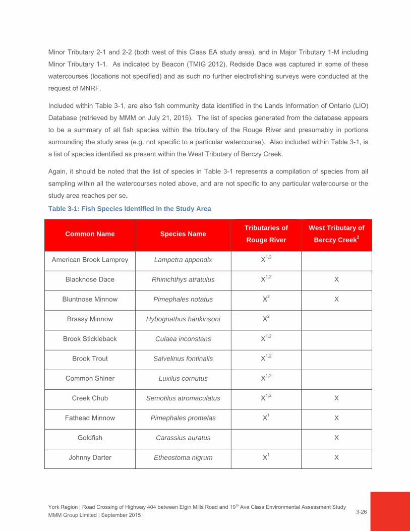
Table 3-1: Fish Species Identified in the Study Area
Common Name Species Name Tributaries of
Rouge River
West Tributary of
Berczy Creek2
American Brook Lamprey Lampetra appendix X1,2
Blacknose Dace Rhinichthys atratulus X1,2 X
Bluntnose Minnow Pimephales notatus X2 X
Brassy Minnow Hybognathus hankinsoni X2
Brook Stickleback Culaea inconstans X1,2
Brook Trout Salvelinus fontinalis X1,2
Common Shiner Luxilus cornutus X1,2
Creek Chub Semotilus atromaculatus X1,2 X
Fathead Minnow Pimephales promelas X1 X
Goldfish Carassius auratus X
Johnny Darter Etheostoma nigrum X1 X

York Region | Road Crossing of Highway 404 between Elgin Mills Road and 19th Ave Class Environmental Assessment Study
MMM Group Limited | September 2015 |
3-27
Common Name Species Name Tributaries of
Rouge River
West Tributary of
Berczy Creek2
Longnose Dace Rhinichthys cataractae X1,2
Mottled Sculpin Cottus bairdii X2
Rainbow Darter Etheostoma caeruleum X1,2
Redbelly Dace Chrosomus eos X1 X
Redside Dace Clinostomus elongatus X1,2 X
Rock Bass Ambloplites rupestris X2
Tadpole Madtom Noturus gyrinus X2
White Sucker Catostomus commersonii X1,2
1 Source: (TMIG 2012) 2 Source: LIO Database (2011)
Most of the fish species identified are associated with cool / warmwater thermal regimes, with the
exception of Brook Trout, American Brook Lamprey and Mottled Sculpin, which are associated with
coldwater habitat conditions. The coldwater species, and some of the coolwater species such as Redside
Dace and Rainbow Darter, are more sensitive to disturbances such as changes to turbidity, temperature
and other water quality and habitat parameters.
During MMM’s field survey in June, 2015, abundant fish fry (species unknown) were noted throughout
Major Tributary 1-M (RR1-a and RR2) and Minor Tributary 2-1 (RR2-1), as well as several baitfish
(including darters). Given these observations, it is assumed that some portions of these reaches support
spawning / rearing habitat for various bait / forage fish, as well as general foraging habitat.
3.3.5 Vegetation and Flora
On the west side of Highway 404, natural vegetation communities are primarily associated with the
tributaries of the Rouge River, and two forested wetlands (Rouge PSW Complex Unit #33 and #34).
These natural features are located within a matrix of agricultural fields with intervening hedgerows. East of
Highway 404, natural vegetation communities are primarily limited to an upland deciduous forest (FOD5-1:
Sugar Maple Deciduous Forest), a small, narrow deciduous forest fragment, and a cultural woodland and
cultural meadow mosaic with a small cattail marsh. The remaining lands are transitioning from a former
agriculture land use to urban development, with some remnant hedgerows. Some early successional

York Region | Road Crossing of Highway 404 between Elgin Mills Road and 19th Ave Class Environmental Assessment Study
MMM Group Limited | September 2015 |
3-28
meadows are also present on lands that are undergoing development (e.g. they have been graded and left
fallow for a few years).
Details of the vegetation species and communities in the study area are presented in the following
sections, and detailed in Appendix C.
Flora Overview
A vascular plant species checklist of the species recorded during MMM’s surveys is provided in
Appendix C, Table 1. In addition, a copy of the species list compiled by Beacon during their investigations
for the North Leslie MESP (TMIG 2012) is also provided in Appendix C (entitled Appendix A-1a-Floral
Inventory). Based on the information gathered through MMM field surveys conducted in 2013, 2014 and
2015, a total of 105 plant species have been identified by MMM within the study area. Four additional
records were identified to genus only.
Of the 105 species recorded by MMM, 40 (38%) are non-native species. Many of these non-native
species are typical of old field and disturbed areas. All of the native species have a provincial ranking of
S4 or S5 (apparently secure (S4) or secure (S5) in Ontario).
Of the two datasets of native species recorded during MMM’s and/or Beacon’s (TMIG 2012) field surveys,
29 are considered locally rare (L1 to L3) in TRCA’s jurisdiction (per TRCA 2003) and/or regionally rare [per
MNRF (Varga 2000 and 2002)]. These species are listed and locations are described in Section 3.3.6.
Vegetation Communities Overview
Vegetation communities on the west side of Highway 404 mapped by Beacon (TMIG 2012) were updated
to reflect some minor changes based on MMM’s field work. Vegetation communities on the east side of
Highway 404 where property access was not available were mapped by MMM based on field
investigations and background information for sites (Cunningham Environmental Associates 2010).
Twenty-one vegetation community types as classified by the ELC system were delineated within the study
area, as shown in Exhibits 3-6a – 3-6e.
None of these community types are provincially rare (Bakowsky 1996). TRCA (2010) ranks nine of the
communities as L5 (generally secure throughout the jurisdiction, including the urban matrix), 11 as L4
(generally secure in the rural matrix, of concern in urban matrix) and one as L+ (exotic). The 21
community types delineated in the study area are listed below followed by the corresponding TRCA L
rank.
CUM1-1 – Dry-Moist Old Field Meadow (L5)
CUP3 – Coniferous Plantation (L5)
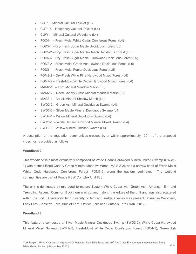
York Region | Road Crossing of Highway 404 between Elgin Mills Road and 19th Ave Class Environmental Assessment Study
MMM Group Limited | September 2015 |
3-29
CUT1 – Mineral Cultural Thicket (L5)
CUT1-5 – Raspberry Cultural Thicket (L4)
CUW1 – Mineral Cultural Woodland (L4)
FOC4-1 – Fresh-Moist White Cedar Coniferous Forest (L4)
FOD5-1 – Dry-Fresh Sugar Maple Deciduous Forest (L5)
FOD5-2 – Dry-Fresh Sugar Maple-Beech Deciduous Forest (L5)
FOD5-4 – Dry-Fresh Sugar Maple – Ironwood Deciduous Forest (L5)
FOD7-2 – Fresh-Moist Green Ash Lowland Deciduous Forest (L5)
FOD8-1 – Fresh-Moist Poplar Deciduous Forest (L5)
FOM2-2 – Dry-Fresh White Pine-Hardwood Mixed Forest (L4)
FOM7-2 – Fresh-Moist White Cedar-Hardwood Mixed Forest (L4)
MAM2-10 – Forb Mineral Meadow Marsh (L5)
MAM2-2 – Reed Canary Grass Mineral Meadow Marsh (L+)
MAS2-1 – Cattail Mineral Shallow Marsh (L4)
SWD2-2 – Green Ash Mineral Deciduous Swamp (L4)
SWD3-2 – Silver Maple Mineral Deciduous Swamp (L4)
SWD4-1 – Willow Mineral Deciduous Swamp (L4)
SWM1-1 – White Cedar-Hardwood Mineral Mixed Swamp (L4)
SWT2-2 – Willow Mineral Thicket Swamp (L4)
A description of the vegetation communities crossed by or within approximately 100 m of the proposed
crossings is provided as follows.
Woodland 2
This woodland is almost exclusively composed of White Cedar-Hardwood Mineral Mixed Swamp (SWM1-
1) with a small Reed Canary Grass Mineral Meadow Marsh (MAM-2-2), and a narrow band of Fresh-Moist
White Cedar-Hardwood Coniferous Forest (FOM7-2) along the eastern perimeter. The wetland
communities are part of Rouge PSW Complex Unit #33.
The unit is dominated by mid-aged to mature Eastern White Cedar with Green Ash, American Elm and
Trembling Aspen. Common Buckthorn was common along the edges of the unit and was also scattered
within the unit. A relatively high diversity of fern and sedge species was present Spinulose Woodfern,
Lady Fern, Sensitive Fern, Bulblet Fern, Ostrich Fern and Clinton’s Fern (TMIG 2012).
Woodland 3
This feature is composed of Silver Maple Mineral Deciduous Swamp (SWD3-2), White Cedar-Hardwood
Mineral Mixed Swamp (SWM1-1), Fresh-Moist White Cedar Coniferous Forest (FOC4-1), Green Ash
York Region | Road Crossing of Highway 404 between Elgin Mills Road and 19th Ave Class Environmental Assessment Study
MMM Group Limited | September 2015 |
3-30
Mineral Deciduous Swamp (SWD2-2), Fresh-Moist Poplar Deciduous Swamp (FOD8-1), Fresh Moist
Green Ash Lowland Deciduous Forest (FOD7-2), and Cultural Woodland (CUW1), and Willow Mineral
Deciduous Swamp (SWD4-1). The wetland communities are part of Rouge PSW Complex Unit #34.
This unit is composed of mid-aged to mature forest with Silver Maple, Bur Oak, Ironwood, American
Beech, Reddish Willow, White Birch and Green Ash. The ground flora contains Scouring Rush, Poison Ivy
and a diversity of ferns and sedges (similar to Woodland 2) (TMIG 2012).
Major Tributary 1-M (RR1) – in the vicinity of the northerly crossing locations; approximately 500 m south
of 19th Avenue
This area is crossed by the northerly conceptual corridor approximately 500 m south of 19th Avenue. This
is approximately 60 m wide vegetation corridor that encompasses the approximately 30 m wide band of
riparian and wetland vegetation along Major Tributary 1-M (RR1). It is composed of Reed Canary Grass
Mineral Meadow Marsh (MAM2-2) adjacent to the watercourse, with Cultural Meadow (CUM1-1) on either
side. There is also a small Willow Mineral Thicket community (SWT2-2) in the southern limit of this
segment.
The Reed Canary Grass Meadow Marsh is dominated by Reed Canary Grass with Canada Anemone,
Field Horsetail, Orange Jewelweed, Purple-stemmed Goldenrod and Spotted Joe-pye Weed. Shrubs and
small trees are scattered throughout and include a diversity of willows (e.g., Peach-leaved Willow, Heart-
leaved Willow, Pussy Willow, Sandbar Willow, Meadow Willow), Trembling Aspen, Common Buckthorn
and Red Osier Dogwood. The adjacent Cultural Meadow is composed of common species typical of
disturbed habitats.
Major Tributary 1-M (RR1a) – in the vicinity of the southerly crossing location; approximately 1 km south
of 19th Avenue
This area is crossed by the southerly crossing concept; approximately 1 km south of 19th Avenue and
includes the zone within approximately 100 m north and 100 m south of the crossing locations. This area
includes Reed Canary Mineral Meadow Marsh (MAM2-2), Cultural Meadow (CUM1-1), Cultural Woodland
(CUW1), and Willow Mineral Deciduous Swamp (SWD4-1).
The Reed Canary Grass Mineral Meadow Marsh community comprises the riparian vegetation along both
sides of Major Tributary 1-M. It is dominated by Reed Canary Grass with frequent Water Smartweed,
Field Horsetail, Spotted Joe-pye Weed, Orange Jewelweed, Canada Anemone, Fringed Loosestrife,
Purple-stemmed Aster, and Small-fruit Bulrush. This unit also has a Narrow-leaved Sedge Mineral
Meadow Marsh (MAM2-5) inclusion that was dominated by Woolly Sedge. There was also one small
York Region | Road Crossing of Highway 404 between Elgin Mills Road and 19th Ave Class Environmental Assessment Study
MMM Group Limited | September 2015 |
3-31
stand of Common Reed (~5m x 5m), an aggressive invasive species, near the south end of this unit on the
west side of the watercourse (UTM 17T 629345E, 4863075N).
The Cultural Meadow on the west side of the watercourse has developed on recently cleared land. There
were several buildings at this location that were removed and the ground was leveled. The vegetation on
this site is composed of common, disturbance tolerant species.
The Cultural Woodland is primarily composed of Black Walnut with White Cedar along the eastern edge.
A few Norway Maple are present upslope close to the abandoned residence. The understory is sparse
with some Green Ash saplings, Red-berried Elderberry and Choke Cherry. The ground flora is primarily
composed of Orange Jewelweed, White Avens, Field Horsetail, Lance-leaf Aster, Thicket Creeper, Tall
Goldenrod and Wild Mock-cucumber. There are also a few large patches of Japanese Knotweed, an
invasive species, near the abandoned house, along the northern edge of the unit and a few patches
scattered throughout.
The Willow Mineral Deciduous Swamp is composed of mid-aged and mature White Willow, Black Walnut,
and Silver Maple, with Green Ash abundant in the sub-canopy. The understory is primarily composed of
Green Ash and Common Buckthorn. The ground flora is primarily composed of Orange Jewelweed, Field
Horsetail, Tall Buttercup, Herb-robert, Enchanter’s Nightshade, Canada Anemone, with Forget-me-not
abundant along the watercourse edge.
Woodland 13
This is a very small remnant woodland located on the east side of Highway 404. Property access was not
permitted during MMM’s field surveys. Field investigations were previously completed in this feature by
Cunningham Environmental Associates (2010) and it was classified as a Dry-Fresh Sugar Maple-Ironwood
Deciduous Forest (FOD5-4). It was described as a “small upland stand of hardwoods dominated by sugar
maple and ironwood. Other woody associated included scattered white pine, white elm, black cherry, and
basswood, with a shrub stratum of choke cherry, common buckthorn and wild red raspberry. The sparse
groundcover contained enchanters nightshade, wild sarsaparilla and blue cohosh” (page 29, Cunningham
Environmental Associates 2010). Since the time of this survey, the northern half of this unit has been
removed for development.
Cultural Woodland / Cultural Meadow / Cattail Shallow Marsh
This unit corresponds with WSU 6, between Honda Boulevard and Woodbine Avenue Bypass. It includes
a Cultural Woodland (CUW1) that is composed of a stand of primarily planted non-native trees and is
dominated by Little-leaf Linden with occasional White Poplar and White Elm. There is also a Cultural

York Region | Road Crossing of Highway 404 between Elgin Mills Road and 19th Ave Class Environmental Assessment Study
MMM Group Limited | September 2015 |
3-32
Meadow (CUM1-1) that includes scattered trees and shrubs of Norway Maple, Green Ash, Manitoba
Maple, Trembling Aspen, Common Buckthorn and Chokecherry. The Cultural Meadow ground flora was
primarily composed of Smooth Brome, Tall Goldenrod, Yellow Bedstraw, Kentucky Bluegrass, Tufted
Vetch, Timothy and Tall Buttercup. There is also a small Cattail Shallow Marsh (MAS2-1) towards the
east side of this unit that is dominated by Broad-leaved Cattail.
3.3.6 Wildlife
Habitat features present within the study area and broader landscape include urban / sub-urban
environments, agricultural fields, semi-natural vegetation features (e.g., cultural meadows, thickets and
hedgerows) and natural vegetation features (e.g., riparian corridor, forested areas); however, the
landscape is dominated by urban / sub-urban and agricultural land uses. Habitats within the study area
show varying levels of human maintenance and history, providing habitat conditions that are more
dynamic in nature, as regenerating areas advance in age, or are periodically managed. The suite of
wildlife species typically found in such habitats is usually ‘opportunistic’, typical of open field habitats and
smaller, more isolated natural / semi-natural forest patches. The portion of the study area west of Highway
404 contains more natural habitat features, while the area east of Highway 404 is more developed (Honda
and Enbridge facilities).
A total of 52 wildlife species were observed directly or identified indirectly through sign (e.g., auditory,
track evidence) during MMM’s field investigations (2013 and 2015), and an additional six species were
observed by Beacon in 2011 (grand total 2011-2015 = 58 species). The observed wildlife species were
made up of 45 birds, four amphibians and nine mammals. These species are listed in Appendix C,
Table 3 and discussed in the subsequent sections.
Two SAR birds were recorded, Barn Swallow (Riparia riparia) and Eastern Wood-Pewee (Contopus
virens), as discussed as follows. All other wildlife species recorded are considered common or secure /
apparently secure (S-Ranks of S5, S5B, S5N, S4, or S4B).
A key Significant Wildlife Habitat feature in WSU 1 is the heronry, which was found to contain 62 Great
Blue Heron nests in 2014 (CEG 2014). The heronry and appropriate buffers are discussed further in this
section, and in Section 6.2.2.5.3. No other Significant Wildlife Habitat features were identified by MNRF or
confirmed in the field, however, potential for at least one other is noted in this section.
Other notable wildlife habitat features include:
Two beaver dams: one located in WSU 3 near the Alternative 1A, 1Bi and 1Bii crossing of Major Tributary 1-M and one 50 m upstream of the Alternative 2 crossing of Major Tributary 1-M. The dam in WSU 3 appeared to be non-active during 2015 field investigations;

York Region | Road Crossing of Highway 404 between Elgin Mills Road and 19th Ave Class Environmental Assessment Study
MMM Group Limited | September 2015 |
3-33
Potential SAR bat roosting and/or maternity colony habitat in WSU 4, consisting of a barn, abandoned house and riparian forest area (although none were observed during the field surveys, it is possible that tree cavities are present). If habitat use by bats was confirmed in accordance with MNRF’s definitions4, such habitat would be considered Significant Wildlife Habitat;
Rock / concrete debris piles and abandoned structures in WSU 4 that provide suitable habitat for Milksnake; however, no potential reptile hibernacula features were observed;
A pair of Red-tailed Hawks (Buteo jamaicensis) seen perched in the same location (northern edge of WSU 4) during the two 2015 field surveys. No stick nests were observed, but it is likely they are nesting nearby; and,
Small cattail marsh in WSU 6 and vernal pools / forested swamp in WSU 1 and 2 that are suitable for amphibian breeding habitat.
Birds
Birds species recorded in the study area are typical and commonly found in forest edge, agricultural,
cultural meadow and urban / semi-urban areas. Most of the recorded bird species are tolerant of urban /
semi-urban disturbance, such as American Robin (Turdus migratorius), Black-capped Chickadee (Poecile
atricapillus), American Goldfinch (Spinus tristis), Cedar Waxwing (Bombycilla cedrorum) and European
Starling (Sturnus vulgaris). Other species observed are associated with wetland, marsh and riparian
habitats, including Red-winged Blackbird (Agelaius phoeniceus), Willow Flycatcher (Agelaius phoeniceus)
and Common Yellowthroat (Geothlypis trichas).
The greatest avian diversity was found in WSU 4 with 26 species; this is expected given the mixture
habitats, including riparian forest and meadow, adjoining woodland (connected with WSU 1), and open /
regenerating areas surrounding the abandoned farmhouse.
Two of the birds recorded are deemed “area sensitive” by the MNRF (2000): White-breasted Nuthatch
(Sitta carolinensis), found in WSU 6, and Savanah Sparrow (Passerculus sandwichensis), found in the
agricultural fields surround WSU 5 and 7.
Two SAR birds, Barn Swallow and Eastern Wood-Pewee, were recorded by both Beacon in 2011 and
MMM in 2013 and 2015. Barn Swallows were seen foraging in agricultural fields throughout the study
area and 13 nests were found in the barn located in WSU 4 (UTM 17T 629297E, 4863016N); this barn is
within approximately 50 m of the Alternative 2 road alignment. Eastern Wood-pewee was detected with a
4 Significant Wildlife Habitat (SWH) is defined as >10 Big Brown Bats or >5 Silver-Haired bats found roosting in a tree cavity or structure. However, if 1 SAR bat was identified in a tree cavity or structure, then most likely that habitat would be classified as SAR habitat and not SWH.
York Region | Road Crossing of Highway 404 between Elgin Mills Road and 19th Ave Class Environmental Assessment Study
MMM Group Limited | September 2015 |
3-34
‘Probable’ level of breeding evidence in the wooded area at the southern edge of WSU 4 and in the largest
woodland (WSU 1).
The study area has a low to reasonable potential for supporting a number of other SAR birds; potential for
SAR is assessed further in the habitat screening as discussed in Section 3.3.6.
Mammals
Six mammal species were recorded by MMM in 2013 and 2015 and additional three species were
recorded by Beacon (TMIG 2012): Beaver (Castor canadensis, non-active dam in 2015), Coyote (Canis
latrans), Eastern Chipmunk (Tamias striatus), Grey Squirrel (Sciurus carolinensis), Meadow Jumping
Mouse (Zapus hudsonius), Woodland Jumping Mouse (Napaeozapus insignis), Raccoon (Procyon lotor),
Red Fox (Vulpes vulpes) and White-tailed Deer (Odocoileus virginianus).
Habitat conditions are likely to support a number of other mammal species commonly found in this region,
Eastern Cottontail (Sylvilagus floridanus), Red Squirrel (Tamiasciurus hudsonicus), Striped Skunk
(Mephitis mephitis), Woodchuck (Marmota monax), and small mammals such as Meadow Vole (Microtus
pennsylvanicus), White-footed Mouse (Peromyscus leucopus) and Deer Mouse (Peromyscus
maniculatus).
None of the recorded mammal species are SCC and all have a provincial S-Rank of 5 (Secure). The study
area has potential to support SAR mammals, including Little Brown Bat (Myotis lucifugus) and Northern
Long-eared Bat (Myotis septentrionalis), as discussed further in Section 3.3.6.
Herpetiles
The woodlands found in the study area (WSU 1 and 2) are part of the Rouge PSW Complex and contain
vernal pools that provide suitable amphibian breeding habitat. The floodplain areas surrounding Major
Tributary 1-M, as well as a small marsh in WSU 6 also have potential to support common amphibian
species. During the amphibian calling surveys undertaken by Beacon (TMIG 2012), three amphibian
species were recorded in the study area: American Toad (Bufo americanus) Western Chorus Frog
(Pseudacris triseriata) and Wood Frog (Rana sylvatica). Northern Leopard Frog (Rana pipiens) was seen
by MMM in WSU 6. Given the habitat conditions, it is likely that two other species commonly found in this
region are present: Green Frog (Lithobates clamitans) and Spring Peeper (Pseudacris crucifer).
No snake or turtle species were recorded by Beacon or MMM during field surveys. However, the study
area and broader landscape habitats provide potential to support common reptile species, including
Eastern Gartersnake (Thamnophis sirtalis sirtalis), Dekay’s Brownsnake (Storeria dekayi) and Red-bellied
Snake (Storeria occipitomaculata).

York Region | Road Crossing of Highway 404 between Elgin Mills Road and 19th Ave Class Environmental Assessment Study
MMM Group Limited | September 2015 |
3-35
One herpetile SAR was confirmed in the study area: Western Chorus Frog (Great Lakes / St. Lawrence -
Canadian Shield population) was heard in reach RR-1 and is designated as Threatened by COSEWIC and
protected under SARA (Schedule 1). In addition, the habitats within the study area and broader landscape
could potentially support several herpetile SAR: Eastern Ribbonsnake (Thamnophis sauritus), Milksnake
(Lampropeltis triangulum), and Snapping Turtle (Chelydra serpentine), as discussed further in
Section 3.3.6.
3.3.7 Designated Natural Features and Species of Conservation Concern
Prior to field surveys, a list of SCC with potential to be present within the study area was generated by
compiling a ‘long list’ of SCC known to be present in the general vicinity based on background resources
(e.g., previous reports from the area, NHIC records, MNRF Regional SAR species lists and MNRF / TRCA
consultation). This long list was then screened in relation to the habitats present in the study area to
exclude those species with no potential to be present. Observations by MMM during 2013, 2014 and 2015
either confirmed presence of these SCC and/or augmented the list. SCC that were not confirmed, but for
which study area habitats provided potential, were also noted.
All SCC found during the field surveys were recorded and are listed in this section.
SCC Confirmed in the Area
Field surveys by MMM in 2013, 2014 and 2015, and Beacon (TMIG 2012) confirmed the presence of 39
SCC within the study area:
Three SAR:
o Barn Swallow (Hirundo rustica) – Designated as Threatened by COSEWIC and COSSARO; protected under SARA and ESA (2007). Nesting confirmed in WSU 4 barn and the “Children’s Aid” Building on Leslie Street adjacent to WSU 1 (2015). Seen foraging over agricultural fields throughout site (observed by MMM in 2013 / 2015).
o Eastern Wood-Pewee (Contopus virens) – Listed as Special Concern by COSEWIC and COSSARO, and listed under the ESA (2007) Probable level of breeding evidence for WSU 1 and 4 (2011 and 2015)
o Western Chorus Frog (Pseudacris triseriata) – The Great Lakes / St. Lawrence - Canadian Shield population of this species is designated as Threatened by COSEWIC and protected under SARA (Schedule 1). Beacon (2012) reported calling in reach RR-1 (north of Alternative 1A, 1Bi and 1Bii crossing of Major Tributary 1-M)
Two bird species are considered ‘Area Sensitive’ by MNRF (2000):
o Savannah Sparrow (Passerculus sandwichensis). Probable level of breeding evidence in agricultural fields within / adjacent to WSU 5 and 7 (2015)
o White-breasted Nuthatch (Sitta carolinensis). Possible level of breeding evidence in WSU 6 (2015)
Six wildlife species are listed as Species of Concern (L1-L3) by the TRCA (regional significance):
York Region | Road Crossing of Highway 404 between Elgin Mills Road and 19th Ave Class Environmental Assessment Study
MMM Group Limited | September 2015 |
3-36
o Great Blue Heron (Ardea Herodias) – L3. Annual monitoring by Beacon has documented growth of the heronry in WSU 1 from 36 active nests in 2011 to 62 active nests in 2014; nesting activity was re-confirmed in 2015 by MMM (no detailed nest counts completed).
o Wild Turkey (Meleagris gallopavo) – L3. Possible level of breeding evidence in WSU 1 (2015).
o Northern Leopard Frog (Lithobates pipiens) – L3. Observed by MMM in suitable breeding habitat in WSU 6.
o Wood Frog (Lithobates sylvaticus) – L2. Recorded by Beacon during amphibian calling surveys in WSU 1 (TMIG 2012).
o Meadow Jumping Mouse (Zapus hudsonius) – L3. Observed by Beacon in WSU 1, 2 and 4 (TMIG 2012).
o Woodland Jumping Mouse (Napaeozapus insignis) – L2. Observed by Beacon in WSU 1, 2 and 4 (TMIG 2012).
23 plants species are listed as Species of Concern (L1-L3) by the TRCA (TRCA 2003):
o Highbush Cranberry (Viburnum opulus var. americanum) – L2. Observed by MMM in the Cultural Woodland (CUW1) community along Reach RR1.
o Wild Leek (Allium triccocum) – L3. Observed by MMM in PSW Unit #33 / Woodland 2.
o Water Smartweed (Persicaria amphibia) – L3. Observed by MMM in the Meadow Marsh (MAM2-2) community along Reach RR1a, upstream of the confluence with Reach RR2-1. Also observed by Beacon (TMIG 2012) in Woodland 8.
o Meadow Willow (Salix petiolaris) – L3. Observed by MMM in the Meadow Marsh (MAM2-2) community along Reach RR1a, between Rouge River Tributary (1-1) and Reach 1-3.
o Beaked Sedge (Carex utriculata) – L3. Observed by Beacon (TMIG 2012) in PSW Unit 33.
o Multi-coloured Blue-flag (Iris versicolor) – listed as L3 by TRCA. Observed by Beacon (TMIG 2012) in PSW Unit 33.
o Michigan Lily (Lilium michiganense) – L3. Observed by Beacon (TMIG 2012) in Woodlands 3, 8, and 9.
o Great Lobelia (Lobelia siphilitica) – L3. Observed by Beacon (TMIG 2012) in Woodland 8 and PSW Unit 33.
o Naked Miterwort (Mitella nuda) – L3. Observed by Beacon (TMIG 2012) in Woodland 3.
o Smaller Forget-me-not (Myosotis laxa) – L3. Observed by Beacon (TMIG 2012) in Woodland 2 and 3.
o Woolly Sweet-cicely (Osmorhiza claytonia) - L3. Observed by Beacon (TMIG 2012) in Woodland 3.
o White Spruce (Picea glauca) – L3. Observed by Beacon (TMIG 2012) in Woodlands 8 and 9.
o Red Pine (Pinus resinosa) – L1. Observed by Beacon (TMIG 2012) in Woodland 8.
o Hairy Solomon’s-seal (Polygonum pubescens) – L3. Observed by Beacon (TMIG 2012) in Woodland 3.
o Old-field Cinquefoil (Potentilla simplex) – L3. Observed by Beacon (TMIG 2012) in Woodland 3.
o Bristly Buttercup (Ranunculus pensylvanicus) – L3 by TRCA and Rare (R7) by Varga (2002). Observed by Beacon (TMIG 2012) in PSW Unit 33.
o Wild Red Current (Ribes triste) – listed as L3 by TRCA. Observed by Beacon (TMIG 2012) in PSW Unit 33.
o Sheep Sorrel (Rumex acetosella ssp. acetosella) – listed as L3 by TRCA. Observed by Beacon (TMIG 2012) in Woodlands 2 and 3.

York Region | Road Crossing of Highway 404 between Elgin Mills Road and 19th Ave Class Environmental Assessment Study
MMM Group Limited | September 2015 |
3-37
o Great Water Dock (Rumex orbiculatus) – listed as L3 by TRCA. Observed by Beacon (TMIG 2012) in PSW Unit 33.
o Hard-stemmed Bulrush (Scirpus acutus) – listed as L3 by TRCA and Rare (R5) by Varga (2002). Observed by Beacon (TMIG 2012) in Woodland 8.
o Wool-grass (Scirpus cyperinus) – L3. Observed by Beacon (TMIG 2012) in Woodlands 2 and 3.
o Purple Trillium (Trillium erectum) – L3. Observed by Beacon (TMIG 2012) in Woodland 3.
o Downy Arrow-wood (Viburnum rafinesquianum) – listed as L3 by TRCA and Rare (R3) by Varga (2002). Observed by Beacon (TMIG 2012) in Woodlands 2 and 9.
Eight plant species are regionally rare (R-Rank) by MNRF (Varga 2000 & 2002) (2 of these plants overlap with the TRCA Species of Concern listed above).
o Old-field Cinquefoil (Potentilla simplex) – R1. Observed by Beacon (TMIG 2012) in Woodland 3.
o Woolly Sedge (Carex pellita) – R8. This species was observed by MMM and dominated a vegetation inclusion within the north extension of the Meadow Marsh (MAM2-2) community along Reach RR1a, upstream of the confluence with Reach RR2-1.
o Silky Dogwood (Cornus amomum ssp. obliqua) - R7. Observed by MMM in the Meadow Marsh (MAM2-2) community along Reach RR1a, between Rouge River Tributary (1-1) and Reach 1-3.
o Virginia Stickseed (Hackelia virginiana) – R5. Observed by MMM in the Cultural Woodland (CUW1) and the Willow Deciduous Swamp (SWD4-1) adjacent to the confluence of RR2 and RR2-1.
o Small-fruited Bulrush (Scirpus microcarpus) – R10. Observed by MMM in the Meadow Marsh (MAM2-2) community along Reach RR1a, upstream of the confluence with Reach RR2-1.
o Black Walnut (Juglans nigra) - R. Observed by MMM in the Cultural Woodland (CUW1) and the Willow Deciduous Swamp (SWD4-1) adjacent to the confluence of RR2 and RR2-1. Appears to have been planted in CUW1.
o Blunt Broom Sedge (Carex tribuloides) – R3. Observed by Beacon in Woodland 3.
o Bristly Buttercup (Ranunculus pensylvanicus) – R7. Observed by Beacon (TMIG 2012) in PSW Unit #33.
Redside Dace
MNRF and TRCA indicated that Major Tributary (1-M) is currently regulated and managed as occupied
habitat for Redside Dace and Minor Tributaries (1-1 and 2-1) are managed as contributing habitat for
Redside Dace. The West Tributary of Berczy Creek, in the eastern portion of the study area, is also
contributing habitat for Redside Dace. Redside Dace is designated as Endangered by the COSEWIC, but
remains listed as Special Concern under the SARA, pending up-listing. Redside Dace is listed as
Endangered under the ESA (2007).
The DFO SAR distribution mapping also shows that all three of these tributaries as supporting potential
habitat for either American Eel (Anguilla rostrata) or Redside Dace. American Eel is designated as
Threatened by COSEWIC, and listed as under consideration by SARA. Through correspondence with
MNRF, it was confirmed that American Eel is not known to occur in these tributaries (SAR screening; pers.
comm. MNRF Aurora Assistant SAR Biologist, April 2013) and the mapped species is therefore Redside

York Region | Road Crossing of Highway 404 between Elgin Mills Road and 19th Ave Class Environmental Assessment Study
MMM Group Limited | September 2015 |
3-38
Dace. As mentioned in Section 3.3.1, no fish sampling could be conducted on any of the watercourses
within the study area.
There are only a few small sections within Major Tributary 1-M that appear to present themselves as ideal
habitat for this species e.g., tight width to depth ratio, low gradient stream with abundant overhanging
vegetation and undercut banks. During MMM field surveys, less than ideal habitat conditions were
recorded at both the alternative road crossings, but in particular at Alterative 2. These conditions include
flooded channel sections (due to the beaver dams), very turbid water (indicating high sediment transport),
permanent barriers to fish movement, and in many sections only gently sloping banks and shallow depths,
apparently reflecting lateral widening. The permanent barrier at the Alternative 2 crossing would prevent
any seasonal movement of Redside Dace upstream between habitat elements.
During an agency meeting with the MMM project team held on November 5, 2013, it was noted by TRCA
staff that substantial research on Redside Dace has been conducted within the Rouge River Tributaries of
the study area. This research was conducted in collaboration with MNRF and TRCA. Information collected
/ analyzed includes distribution, habitat element use and seasonal migration patterns of Redside Dace.
MNRF did not provide these specific data in relation to Redside Dace distribution or relative habitat quality
along the subject reaches to that this information could not be incorporated into the evaluation process for
the alternative alignments. As noted, MNRF did emphasize that the study reaches are part of a habitat zone
extending from Stouffville Road to Major MacKenzie that is considered to support a “stronghold population”
of Redside Dace; these reaches have been identified as a Conservation Reserve in the Rouge River Fish
Management Plan (2011 working draft). However, at this juncture, they have not distinguished relative
habitat quality within this broader zone as input to this project.
SAR with Potential to Occur
A review of background information sources (OBBA, NHIC and MNRF Regional SAR Lists) in combination
with the assessment of the available habitat indicated there is potential for several additional SAR to occur
within the study area or in the vicinity of the study area. None of these species were recorded in the study
area during either MMM’s or Beacon’s field surveys. As noted earlier, the only SAR wildlife species
recorded during field surveys were Barn Swallow, Eastern Wood-Pewee and Western Chorus Frog.
However, given the habitat characteristics present in the study area and occurrences of these species in the
broader landscape, the following SAR have a low to reasonable likelihood of occurring in the study area:
Bobolink – designated as Threatened by COSEWIC and listed as Threatened under the ESA (2007). Unlikely to breed in the study area, but may occur as migrant/visitor. No suitable nesting habitat was observed on-site; no large grassland, pasture or hayfields and most agricultural fields were planted with row or speciality crops. Fields surrounding WSU 5 were planted with wheat (marginally suitable nesting habitat); however, these fields are disturbed by Highway 404 traffic and urban development.

York Region | Road Crossing of Highway 404 between Elgin Mills Road and 19th Ave Class Environmental Assessment Study
MMM Group Limited | September 2015 |
3-39
Eastern Meadowlark – designated as Threatened by COSEWIC and listed as Threatened under the ESA (2007). Unlikely to breed in the study area, but may occur as migrant/visitor. No suitable nesting habitat was observed on-site; no large grassland, pasture or hayfields and most agricultural fields were planted with row or speciality crops. Fields surrounding WSU 5 were planted with wheat (marginally suitable nesting habitat); however, these fields are disturbed by Highway 404 traffic and urban development.
Red-headed woodpecker – designated as Threatened by COSEWIC and listed as Special Concern under the ESA (2007). Unlikely to breed in the study area (no records in OBBA) and more likely ‘migrant/visitor’ use only, but known to inhabit a variety of open woodland and woodland edge habitats, which are present within the study area.
Wood Thrush – designated as Threatened by COSEWIC and listed as Special Concern under the ESA (2007). Reasonable likelihood to breed in the study area. Detected north of the study area by Beacon (TMIG 2012). Known to inhabit mid-aged to mature deciduous forest, which is present within the study area; however, Wood Thrush prefers large, upland forests with a well-developed understory, which is not present in the study area.
Little Brown Bat, Small-Footed Myotis and Northern Long-eared Bat – all listed as Endangered under the ESA (2007); Little Brown Bat and Northern Long-eared Bat designated as Endangered by COSEWIC. Reasonable likelihood of occurring in the project area. Not detected during field surveys; however, targeted acoustic monitoring/exit surveys were not completed. Suitable roosting and/or maternity colony habitat may be present in tree cavities, barns or abandoned buildings (WSU 1 and 4).
Eastern Ribbonsnake – designated as Special Concern by COSEWIC and listed as Special Concern under the ESA (2007) and Schedule 3 of SARA. Reasonable likelihood to occur in the study area; suitable habitat is present in wet grassy areas along the riparian corridor (WSU 3 and 4).
Milksnake – designated as Special Concern by COSEWIC and listed as Special Concern under the ESA (2007) and Schedule 1 of SARA. Reasonable likelihood to occur in the study area; known to inhabit a variety of habitats in rural areas and surrounding old structures (barn, abandoned building and rock / concrete debris piles in WSU 4).
Blanding’s Turtle – designated as Threatened by COSEWIC and listed as Threatened under the ESA (2007) and Schedule 1 of SARA. Unlikely to ‘reside / use habitat in the study area since no slow-flowing rivers or wetland habitat of sufficient size and depth for overwintering habitat are present on-site. But may pass through study area along the riparian corridor (known to travel up to 2 km between habitats).
Snapping Turtle – designated as Special Concern by COSEWIC and listed as Special Concern under the ESA (2007) and Schedule 1 of SARA. Unlikely to ‘reside / use habitat in the study area given absence of generally suitable habitat, however known to travel through or periodically use a variety of wetland and stream habitats. Marginally suitable overwintering habitat is present in the SWM Pond (soft bottom with water greater than 1 m depth); however, this feature is isolated from other natural features by roads, buildings and silt fencing. Therefore, Snapping Turtles may travel along the Rouge River Tributary; however, they are unlikely to nest or overwinter here due to insufficient depth, basking sites and foraging opportunities.
Monarch – designated as Special Concern by COSEWIC and listed as Special Concern under the ESA (2007) and Schedule 1 of SARA. Reasonable likelihood to occur in the study area; Common Milkweed found in the study area (WSU 4 and 6).
Butternut – designated as Endangered by COSEWIC and listed as Endangered under the ESA (2007) and Schedule 1 of SARA. This species was not recorded by MMM or Beacon within the Highway 404 Crossing study area. There is some potential for it to occur in areas removed from the Alternative Alignments where thorough surveys were not completed or where surveys could not be completed due to lack of property access (e.g., in hedgerows along Alternative Alignment 1A, east of Highway 404, although habitat here is marginal).
York Region | Road Crossing of Highway 404 between Elgin Mills Road and 19th Ave Class Environmental Assessment Study
MMM Group Limited | September 2015 |
3-40
3.4 DRAINAGE and FLUVIAL GEOMORPHOLOGY
MMM has obtained relevant drainage-related information, reports, contour map, flood plain mapping and
hydraulic model from the Regional Municipality of York (hereafter referred to as “Region”) and the Toronto
and Region Conservation Authority (TRCA). The list of reports reviewed for the background use in the
drainage assessments of this study are provided in the Drainage and Stormwater Management Report,
which can be found in Appendix F.
Field investigations of the study area and existing drainage features were conducted by MMM Group in
June 2013 and July 2015. Photographic inventory of the site investigations is provided in the Drainage and
Stormwater Management Report, provided in Appendix F.
3.4.1 Existing Land Use, Drainage and Hydrology
The study area lies within the watershed of the Rouge River Tributary. The predominant soil types in the
study area are Tecumseth sandy loam and Milliken loam. Topography is gently sloping toward the south.
There is an existing collapsed culvert in the Rouge River Tributary valley, approximately 1 km south of 19th
Avenue, which was used as farm crossing (i.e. 11221 Leslie Street). The upstream side of the culvert could
not be located and is assumed to be buried. On the downstream side, the culvert measured 750 mm
diameter. Some flow was observed through the culvert but most of the flow was draining from the farm
track.
On the west side of Highway 404, in the Town of Richmond Hill, runoff from the farmland drains overland to
the Rouge River Tributary. On the east side of Highway 404, runoff from the study area drains overland to
the existing SWM Pond L1. Pond L1 was designed in 2008 by 404 North Developers Groups for the 404
North Secondary Plan (OPA 149).
SWMHYMO was used to generate the flow rates. For the Rouge River watershed, the AES storm
distribution is the governing storm event, as per the TRCA guideline. However, the 12-hour SCS storm
distribution was used on the east side of Highway 404 (City of Markham) for designing the existing SWM
Pond L1 and for the stormwater management design of the Rice Commercial Group’s current development
site. Therefore, both the 12-hour AES storm distribution and the 12-hour SCS storm distribution were used
to generate the pre-development flows for the 2-year to 100-year storm events for comparison purpose. The
12-hour SCS storm distribution generated higher flow values, and therefore, the SCS storm distribution
used for the design. This is consistent with the storm distribution used for the SWM Pond L1 and the Rice
Commercial Group’s development site. Table 3-2 provides the pre-development flows based on the SCS
storm distribution.

York Region | Road Crossing of Highway 404 between Elgin Mills Road and 19th Ave Class Environmental Assessment Study
MMM Group Limited | September 2015 |
3-41
Table 3-2: Pre-development Conditions Flows (12-hour SCS Storm Distribution)
Catchment ID / HYD #
Flows (m3/s)
2-year 5-year 10-year 25-year 50-year 100-year
110 0.008 0.013 0.017 0.023 0.027 0.032
120 0.017 0.027 0.036 0.049 0.059 0.070
500 (AddHyd 100+120) 0.021 0.033 0.044 0.060 0.072 0.085
130 0.007 0.010 0.014 0.019 0.022 0.026
140 0.008 0.012 0.016 0.022 0.026 0.030
510 (AddHyd 130+140) 0.014 0.022 0.029 0.040 0.048 0.056
150 0.013 0.020 0.026 0.035 0.041 0.048
160 0.020 0.030 0.040 0.054 0.063 0.074
A1 0.023 0.035 0.045 0.061 0.072 0.085
Catchments 110 to 150 are located on the west side of Highway 404, and Catchments 160 and A1 are
located on the east of Highway 404. Catchment A1 is the roadway area located to the east of Pond L1,
which was included in the Rice Commercial Group’s development report. The summary output files of the
pre-development hydrological modelling are provided in the Drainage and Stormwater Management Report,
provided in Appendix F.
3.4.1.2 Hydraulic Assessment
The HEC-RAS hydraulic model of the Rouge River Tributary was obtained from TRCA. The existing
conditions hydraulic model was revised by adding new cross-sections and editing cross-sections both on
the upstream and downstream sides of the proposed roadway alignment. The cross-sections were obtained
from the latest topographic survey along the proposed roadway alignment of the Rouge River Tributary
crossing.
A comparison of the results between the existing model and the revised existing model shows that the
water levels of the revised existing model at Sections 7101.14, 7101.15 and 7101.16, located upstream of
the farm track along the Rouge River Reach RR1A. The revised existing model is considered as the base
for comparison purpose with the proposed model.
The HEC-RAS cross-section locations and summary output files are provided in the Drainage and
Stormwater Management Report in Appendix F.
York Region | Road Crossing of Highway 404 between Elgin Mills Road and 19th Ave Class Environmental Assessment Study
MMM Group Limited | September 2015 |
3-42
3.4.2 Fluvial Geomorphology
3.4.2.1 Background
As part of the EA Study, an investigation was carried out to assess options and geomorphic impacts
associated with a new crossing over a tributary to the Rouge River (Rouge River East Branch 1-M). The
study area lies within the jurisdiction of the TRCA. The assessment focused on two areas where the
crossing of Rouge River Tributary per the conceptual crossing location in Chapter 5 of the Environmental
Study Report – i.e. approximately 0.5 km south of 19th Avenue and approximately 1 km south of 19th
Avenue. Exhibits 5-2 to 5-5 present the crossing locations of the alternative design concepts.
The meander belt represents the limits in which a river is likely to meander over time. The belt width is an
important tool which can be used to plan for and mitigate the risk of erosion to infrastructure and to provide
sufficient space around watercourses to allow natural geomorphic processes to occur. In the case of the
Rouge River Tributary, a meander belt assessment is required for the Ministry of Natural Resources and
Forestry (MNRF) approval of new watercourse crossings.
Previous meander belt studies completed by others gave a range of meander belt widths from 16 m to
49 m at the northerly crossing location (i.e. Alternatives 1A, 1Bi and 1Bii as shown Exhibits 5-2 to 5-4), and
from 24 m to 59 m at the southerly crossing location (i.e. Alternative 2 as shown in Exhibit 5-5). The
smaller belt widths were determined using a map-based procedure. The larger values were determined
using the empirical model presented in the TRCA Belt Width Delineation Procedure (2004) because it was
determined that the map-based belt width procedure could not be followed due to vegetative cover and
channel modification. Following the TRCA belt width delineation procedure and using various empirical
relationships, MMM also calculated a wide range of meander belt widths at the proposed crossing location.
As well it was noted that these methods are intended for naturally functioning channels that meander
across their floodplains and are less reliable for modified headwater systems. Therefore, the Project Team
sought TRCA input to determine the most suitable methodology in determining meander belt width. The
TRCA requested that MMM prepare a technical memorandum justifying an alternative approach. The
baseline conditions and the meander belt assessment of the Rouge River Tributary are provided in
Appendix F.
3.4.2.2 Site Assessment Summary
In 2013, 2014 and 2015 MMM completed a geomorphological site investigation of the Rouge River
Tributary between 19th Avenue to approximately 1.4 km downstream of 19th Avenue. The site walk
extended to reaches upstream and downstream of the proposed creek crossing locations. Reaches had
been previously delineated on the watercourse in the Master Environmental Servicing Plan (2000 and
2013). In the course of the site assessment reaches RR1 and RR1-A were subdivided into RR1, RR1-A
RR1-B and RR1-C due to differences in channel form and management history. Reach locations are
presented in Figure 1 of the Meander Belt Technical Report in Appendix F.
York Region | Road Crossing of Highway 404 between Elgin Mills Road and 19th Ave Class Environmental Assessment Study
MMM Group Limited | September 2015 |
3-43
The initial site investigation was completed in July of 2013. This included reaches RR1 to the upstream
portion of RR1-C, as permission to enter was not granted in the middle portion of the block. The site
assessment of reaches RR1-C and RR2 and a spot check on RR2-1 (Minor Tributary 2-1) were completed
in December 2014 and July of 2015. During the July 2013 and 2015 site visits, weather conditions were
dry and flows were below bankfull. During the December 2014 site visit the channel was partially frozen
and flows were out of bank in reach RR1-C.
Reaches within the study area are located within a deciduous riparian buffer strip surrounded by actively
managed agricultural fields. There is no distinct valley from 19th Avenue to the failed farm lane crossing at
the RR1-C and RR2 reach break. In this area an extensive floodplain is present on either side of the
channel, but floodplain connectivity varies among reaches. Downstream of the failed farm crossing in
RR2, there is a low valley slope west of the channel and an extensive floodplain east of the channel.
Throughout the study area the channel slope is low to moderate and substrate consists primarily of sand
with some silt, gravel and cobble. All reaches appear to have been partially or wholly modified in the past
and are currently in adjustment.
Reaches characteristics are summarized as follows:
Reach RR1 has a straightened planform and modified cross-section. The reach is Transitional (RGA score = 0.24) and the dominant process is lateral adjustment.
At the time of MMM’s site investigation, reach RR1-A was flooded by beaver dams and there was no formal channel present.
Reach RR1-B has a mildly sinuous planform and a fairly natural cross-section with steep to undercut banks. The reach is Transitional (RGA score = 0.22) and the dominant process is lateral adjustment.
Reach RR1-C consists of stretches which retain a modified cross-section interspersed with shorter sections which have a more natural cross-section. In areas the channel is locally backed up and widened by small debris jams. In the downstream portion of the reach a beaver dam forms a 0.5 m drop, which acts as a grade control and may contribute to the maintenance of the willow mineral deciduous swamp located upstream. The reach is Transitional (RGA score = 0.32) and the dominant process is narrowing with lateral adjustment. The downstream reach break is defined by a collapsed farm crossing culvert. This backs up flow and causes the downstream portion of the reach to act as a sediment sink.
In reach RR2 the collapsed farm crossing culvert forms a drop in bed elevation of approximately 1 m. Downstream of the crossing the channel has a straightened planform and modified cross-section. In areas a more natural bankfull cross-section has recovered. The reach is Transitional (RGA score = 0.21) and the dominant process is lateral adjustment.
A spot check was conducted on RR2-1 (Minor Tributary 2-1) from the confluence to the fence line. The tributary has a modified planform. The channel is poorly defined in the upstream part of the reach. A knickpoint is located approximately 20 m from the confluence. The channel downstream of the knickpoint is well-defined and entrenched.
A summary of bankfull characteristics for reaches assessed on the Rouge River Tributary is given in
Table 3-3.

York Region | Road Crossing of Highway 404 between Elgin Mills Road and 19th Ave Class Environmental Assessment Study
MMM Group Limited | September 2015 |
3-44
Table 3-3: Representative Channel Bankfull Dimensions
Reach Bankfull width (m) Bankfull depth (m)
RR1 2.5 0.5
RR1-A N/A N/A
RR1-B 1.5 0.6
RR1-C 3.0 (modified)
1.8 (adjusted)
0.5 (modified)
0.5 (adjusted)
The longitudinal profile of the channel is influenced by two important grade controls located in reaches
RR1-C and RR2. The first of these is the beaver dam located in reach RR1-C. The break down or
removal of the dam could result in a change in bed elevation and local flow characteristics of the area
upstream. This in turn could affect the willow mineral deciduous swamp located along the channel.
At the collapsed farm crossing which marks the start of reach RR2 there is ongoing erosion and risk
potential headcutting. Under existing conditions the collapsed culvert blocks sediment transport
downstream. A channel has formed over the collapsed crossing which has unvegetated vertical bank that
appear to be actively eroding. Continued erosion and transport of the failed fill material poses a risk of
knickpoint migration over time. Knickpoint migration would cause incision within reach RR1-C and a
release of sediment into reach RR2 and would consequently change the channel profile, cross-section and
geomorphic processes as the system adjusts.
Detailed reach descriptions are included in Appendix B of the Meander Belt Width Technical Report
included in Appendix F of this ESR.
3.4.2.3 Approach to Meander Belt Assessment
A multi-pronged approach was used to estimate the meander belt width. The premise is to obtain a range
of belt width measurements and calculations using both map-based and empirical methods. These were
verified in the field and the range of values has collectively informed a final judgment based on expert
opinion.
The approaches used in the assessment include:
Review of the regulatory floodplain extent to confirm that the meander belt is not confined.
Examination of contemporary satellite imagery, historic aerial photographs from 1946 and 1978 and a historic map from 1878.
Measurement of the amplitude and radius of curvature of suitable reference meanders.
Calculation of a range of empirical relations from the literature.
Site validation.
York Region | Road Crossing of Highway 404 between Elgin Mills Road and 19th Ave Class Environmental Assessment Study
MMM Group Limited | September 2015 |
3-45
Based on the historic images, the channel appears to have been straightened by 1946, which is the oldest
historic aerial photograph available. As such, the map-based procedures outlined in the TRCA belt width
delineation procedure (2004) could not be applied. When there is no historic evidence of the natural
planform on the study reaches or on the adjacent reaches, the TRCA Belt Width Delineation Procedure
(2004) recommends using a reference reach as a surrogate. However, most reaches near the study area
possess modified or partially modified planforms. In the absence of ideal reference reaches, the
characteristics of individual reference meanders measured in multiple reaches inform the minimum
meander belt width.
The empirical relations considered the most appropriate for the system were used to calculate a range of
predicted meander belt widths. However, all empirical relations should be used with caution. All empirical
relations are strongly dependent on the dataset from which they were derived and as such are not
applicable to all watercourses. Few relations have been developed specifically for Southern Ontario
streams or for small headwater channels.
Empirical relations based on channel dimensions were not calculated for reach RR1 because the channel
is too modified to represent either a natural or recovered condition, or for reach RR1-A which lacks a
defined channel. Relations based on channel dimensions were calculated for reach RR1-B because the
channel appears to have a more natural cross-section based on field observations. In reaches RR1-C and
RR2 the relations were calculated for the adjusted bankfull channel rather than the modified (overwidened)
channel.
3.4.2.4 Results of the Meander Belt Assessment
The Rouge River Tributary within the potential crossing areas appears to have been straightened, and as
such standard map-based belt width delineation could not be undertaken. The extent of modification
differs among reaches: reach RR1 has a modified channel cross-section, reach RR1-A is located in a
wetland and lacks a defined channel, reach RR1-B appears to have fairly natural or well-recovered
channel cross-section, and reaches RR1-C and RR2 are modified but contain areas that are well-
recovered.
The northerly crossing (i.e. Alternatives 1A, 1Bi and 1Bii as shown in Exhibits 5-2 to 5-4) is located in RR1-
A, which is a wetland with no defined channel. The meander belt width of RR1-B is used as a reference
for this reach because it appears to have a fairly natural or well-recovered channel cross-section. The
southerly crossing (i.e. Alternative 2 as shown in Exhibit 5-5) is located at the reach break between RR1-C
and RR2. The meander belt width of reach RR1-C can be used to inform the span of the southerly
crossing because the energy potential at that location is associated with the upstream reach rather than
the downstream reach. The meander belt will not migrate upstream, and the amount of discharge passing
below the structure is as upstream. Should the crossing location be moved, the further downstream it is
shifted, the more the larger meander belt width associated with RR2 should be considered.

York Region | Road Crossing of Highway 404 between Elgin Mills Road and 19th Ave Class Environmental Assessment Study
MMM Group Limited | September 2015 |
3-46
Table 3-4: Summary of Meander Belt Assessment
Alternative lines of evidence were used to estimate a meander belt width giving a range of results. These
include visual observation of a historic map, measurement of individual reference meanders and empirical
modelling. A historic map dated 1878 was provided to MMM which indicates that the watercourse was
fairly straight throughout the study area in that year. Based on 2006 maps, the maximum amplitude of
reference meanders measured within the study area and from surrounding reaches was 20.7 m. Of the
reference meanders measured, most had a ratio of radius of curvature to bankfull width (Rc/w) of over 2,
which indicates that they are tight and potentially unstable. As a result, and to account for potential
differences between the reference locations and study reaches, the maximum meander amplitude is
considered only a guide to the minimum potential meander belt width.
A range of empirical models were calculated. The TRCA Procedure 5 model was not a factor in final belt
width recommendation because the channel is modified; the model is based on a regression of meander
belt width and the two year flow, but the two year flow is well out of bank in this watercourse. As well,
there is uncertainty associated with the accuracy of the slope information available for its calculation.
Excluding these values appears to be appropriate based on historic mapping. The map from 1878
indicates that the sinuosity and lateral extent of the channel was limited at that time, and as there has
been little notable change in planform shape in the intervening 137 years. Based on the foregoing, it is
concluded that the actual meander belt widths are less than the values predicted by the TRCA model.
Due to the nature of the Williams (1986) equations reviewed, the relation considered most suitable for this
watercourse, which is a narrow headwater channel, is the equation based on channel cross-sectional
area. As the bankfull channel dimensions are very similar between reaches RR1-B (1.5 m wide, 0.6 m
deep, vertical banks, 0.9 m2 area) and the well-adjusted channel cross-sections in RR1-C (1.6 m wide, 0.5
m deep, vertical banks, 0.8 m2 area), the meander belt widths predicted by this equation are very similar.
The belt widths are adjusted to increase downstream to reflect slight increase in drainage area and
discharge. This also follows the typical pattern in unconfined river systems.
Data source Reference Reach RR1-B RR1-C RR2
Northerly Crossing Southerly Crossing
Regulatory floodplain width (m) 150-200
Not a controlling factor
150-300
Not a controlling factor 38-78
TRCA empirical model + 1 std dev. (m) 42.1* 50.4* 55.5*
Williams (1986) area-based equation + 10% factor of safety (m)
18.5 17.1 18.5
Maximum amplitude of reference meanders (including bankfull width) (m)
20.7
Average Rc/w ratio of reference meanders 3.3 (unstable)
Recommended meander belt width (m) 25 30 35
*Based on available slope information. Detailed survey not available.
York Region | Road Crossing of Highway 404 between Elgin Mills Road and 19th Ave Class Environmental Assessment Study
MMM Group Limited | September 2015 |
3-47
Given these considerations the recommended meander belt widths are informed by the maximum amplitude
of reference meanders, the Williams (1986) area equation, field observations of the channel and floodplain,
and the downstream increase in drainage area. Based on this analysis, the meander belt width is 25 m at the
northerly crossing location (i.e. Alternatives 1A, 1Bi and 1Bii) and 30 m at the southerly crossing location (i.e.
Alternative 2). Should more detailed survey or modelling information become available, the meander belt
widths presented here should be reviewed and revised if necessary at detail design.
3.5 HYDROGEOLOGY
An overview of the hydrogeology conditions was prepared at the onset of the EA Study and is summarized
in a memo in Appendix G. The memo summarized background information such as regional
physiography, site-specific physiography and drainage, regional geology, site specific hydrogeology,
aquifer properties as interpreted from MOECC well records, and site-specific groundwater quality. Other
discussion in the memo includes description of environmentally sensitive features in the study area,
baseline surface water quality, groundwater use, and environmental data base query (Ecolog ERIS).
As per the Toronto and Region Authority (TRCA) (2007), the Project Study Area is within the Rouge River
Watershed, whereby the Rouge River drains into Lake Ontario. There are four major physiographic
regions within the Rouge River Watershed, as per Chapman & Putnam (1984): Oak Ridges Moraine, Peel
Plain, South Slope, and Lake Iroquois Sand Plain.
In terms of site specific physiography, within the study area, the ground surface ranges from a low of 225
meters above mean sea level (m AMSL), where the Rouge River flows beneath Elgin Mills Road, to 245 m
AMSL, or top of a drumlin hill, 500 m west of Highway 404 and 900m north of Elgin Mills Road. A similar
topographic high point (245 m AMSL) is reached at the corner of Leslie Street and Elgin Mills Road.
The ground surface generally slopes from north-northwest to south-southeast, towards Lake Ontario.
There is a local relief in the form of gently sloping drumlin hills, and incised creek valleys, whereby the
Rouge River valley floor is up to five meters below the surrounding table land areas. The topography and
drainage in this area has been modified in order to better suit agricultural practices (channelizing smaller
creeks, drainage and construction of dugout ponds), rural residences, road and highway interchanges, and
newer urban developments.
Extensive site grading has been done in the newer residential and commercial developments along Elgin
Mills Road, as well employment lands, including the Honda Canada Corporate office facility located on
Honda Boulevard, east of Highway 404. Many smaller drainage features have been diverted into storm
sewers and storm water management ponds have been constructed. There is one such storm-water
management pond on the east side of Highway 404 south of the Honda Canada complex.
In terms of regional geology, the study area is located within the central-west portion of the Rouge River
Watershed. The Quaternary Geology of in the vicinity of the project site consists of the following
overburden stratigraphic units overlying bedrock (from oldest to youngest) (TRCA, 2007): Scarborough

York Region | Road Crossing of Highway 404 between Elgin Mills Road and 19th Ave Class Environmental Assessment Study
MMM Group Limited | September 2015 |
3-48
Formation, Sunnybrook Drift, Thorncliffe Formation, Newmarket (Northern) Till, Oak Ridges Moraine
Deposits, Halton Till, Glaciolacustrine Deposits (Glacial Lake Peel) and recent alluvial deposits. It is noted
that many of the overburden stratigraphic units, which are found in the Rouge River watershed, are also
found in the adjacent Don River Watershed, which was evaluated in detail by TRCA (2009). In terms of
site specific physiography, the near surface geology within the site area is interpreted to be composed of:
Halton Till, recent Glaciolacustrine Deposits, Alluvial deposit (along the Rouge River and its tributaries),
and organic deposits, also generally in valley lands and low-lying areas.
Regarding regional hydrogeology, groundwater in the Rouge River Watershed generally flows in a south to
southeast direction towards Lake Ontario; however localized groundwater flow is towards drainage
features, such as creeks and rivers (TRCA, 2007). Hydrogeological studies carried out by the TRCA
(2007) indicate the following overburden aquifers in the Rouge River Watershed (from youngest to oldest):
Shallow Aquifer, Oak Ridges Aquifer (Upper Aquifer), Thorncliffe Aquifer (Middle Aquifer), and
Scarborough Aquifer (Lower Aquifer).
According to the TRCA (2007), localized shallow aquifers occur in deeper pockets of sandy
glaciolacustrine deposits as well as within localized sand lenses in the Halton Till, whereas the regionally
extensive Oak Ridges Moraine Aquifer Complex occurs within the Oak Ridges Moraine deposits and the
Mackinaw Interstadial deposits (Tunnel Channels). According to TRCA (2007), the groundwater in the
unconfined shallow aquifer flows horizontally and is generally controlled by the surface topography
because the Halton Till limits downward infiltration. The Thorncliffe Aquifer is located below the
Newmarket Till within the Thorncliffe Formation and the Scarborough Formation is found below the
Sunnybrook Drift aquitard (TRCA, 2007). TRCA (2007) reports that the Oak Ridges Aquifer, Thorncliffe
Aquifer and the Scarborough Aquifers are all confined by units of low hydraulic conductance, except for
regions where these aquifers outcrop. The Oak Ridges Aquifer outcrops on the Oak Ridges Moraine
whereas the Thorncliffe Aquifer and the Scarborough Aquifer only outcrop in deeply incised creek valleys,
and in the shoreline bluffs in the southern portion of the Rouge River Watershed (TRCA, 2007). The
Scarborough Aquifer has greater thickness in select locations where bedrock valleys are present,
particularly the upper reaches of the Rouge River Watershed, as per TRCA (2007).
In terms of site specific hydrogeology, there are two aquifers near the surface in study area, as follows: ·
Surface Aquifers, and Oak Ridges Moraine Aquifer Complex.
As per Morrison Environmental Limited (2000), most of the surficial soils in the study area are fine-grid
and, as such, groundwater recharge rates are interpreted as low to moderate. The Municipal Infrastructure
Group (2012); however, notes that near-surface overburden deposits are commonly weathered, permitting
low to moderate amounts of groundwater infiltration and flow.
Localized surficial aquifers occur within sand and gravel lenses within the glaciolacustrine sediments or
Halton Till deposits. The Groundwater flow in these aquifers is interpreted to reflect the topographic
gradient of the ground surface, and flow towards localized streams (Morrison Environmental Ltd., 2003).
York Region | Road Crossing of Highway 404 between Elgin Mills Road and 19th Ave Class Environmental Assessment Study
MMM Group Limited | September 2015 |
3-49
This same study reported that localized shallow surficial aquifers may cause difficulties during road or
infrastructure construction; however, this problem can be resolved through trenching and sumping.
The Oak Ridges Moraine Aquifer Complex is the upper confined aquifer present within the study area.
Groundwater in this aquifer is reported by Morrison Environmental Limited (2003) to flow in a south-
southeast direction reflecting the regional topographic slope. They also report that there are above ground
artesian conditions present within this aquifer in select areas within the project site, however, despite these
artesian conditions, there is not a significant increase in the base flow to creeks, indicating that these
artesian conditions are contained. A more significant area of artesian conditions is interpreted to be found
immediately north of 19th Avenue, near Leslie Street. According to Morrison Environmental Limited
(2000), due to the drop in topography from the Oak Ridges Moraine, artesian conditions occur in the Oak
Ridges Moraine Aquifer and the Thorncliffe Aquifer in an area immediately north of 19th Avenue. The
Municipal Group (2012) also interprets areas north of 19th Avenue, as well as an area near Elgin Mills
Road and Leslie Street, where these are below ground confined aquifers under artesian pressure,
however, they are largely beyond the Class EA study area.
3.6 CULTURAL HERITAGE RESOUCES
3.6.1 Built Heritage Resources
A Built Heritage Resources and Cultural Heritage Landscapes Report has been completed and can be
found in Appendix D of the ESR. Of the 21 sites identified with heritage significance, most are located
along the boundaries of the study area; except 11221 Leslie Street where the building of the property is
located approximately 250 m west of Highway 404.
3.6.2 Archaeology
A Stage 1 Archaeological Assessment has been completed and can be found in Appendix E of the ESR.
Findings indicated that the Study Area is in close proximity to areas with archaeological potential. A
Stage 2 Archaeological Assessment should be carried out before construction proceeds.
3.7 MAJOR UTILITIES
The TransCanada Pipeline easement runs east-west approximately 400 m south of 19th Avenue through
the study area and continues easterly and westerly beyond the study area boundary. There is a
TransCanada Pipeline station located approximately 400 m west of Woodbine Avenue and 500 m south of
19th Avenue. There are no other existing utilities through the vacant lands within the study area.
A hydro tower corridor is located on the east side of Woodbine Avenue and crosses to the west side of
Woodbine Avenue approximately 800 m south of 19th Avenue. There are existing hydro poles on Elgin
Mills Road, 19th Avenue, Leslie Street, Woodbine Bypass, Woodbine Avenue and Honda Boulevard.