2. 2. uplift of tibetan plateau and chinese climate difference 2.1 circumfluence system structure...
TRANSCRIPT
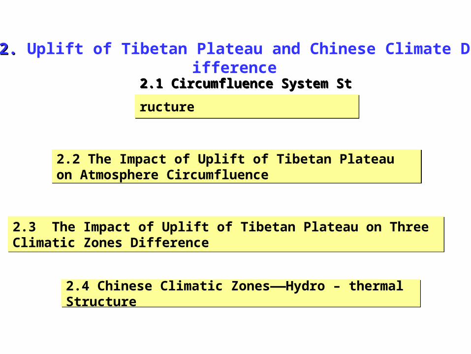
2. 2. Uplift of Tibetan Plateau and Chinese Climate Difference
2.1 Circumfluence System Structure 2.1 Circumfluence System Structure
2.2 The Impact of Uplift of Tibetan Plateau on Atmosphere Circumfluence2.2 The Impact of Uplift of Tibetan Plateau on Atmosphere Circumfluence
2.3 The Impact of Uplift of Tibetan Plateau on Three Climatic Zones Difference2.3 The Impact of Uplift of Tibetan Plateau on Three Climatic Zones Difference
2.4 Chinese Climatic Zones——Hydro – thermal Structure2.4 Chinese Climatic Zones——Hydro – thermal Structure
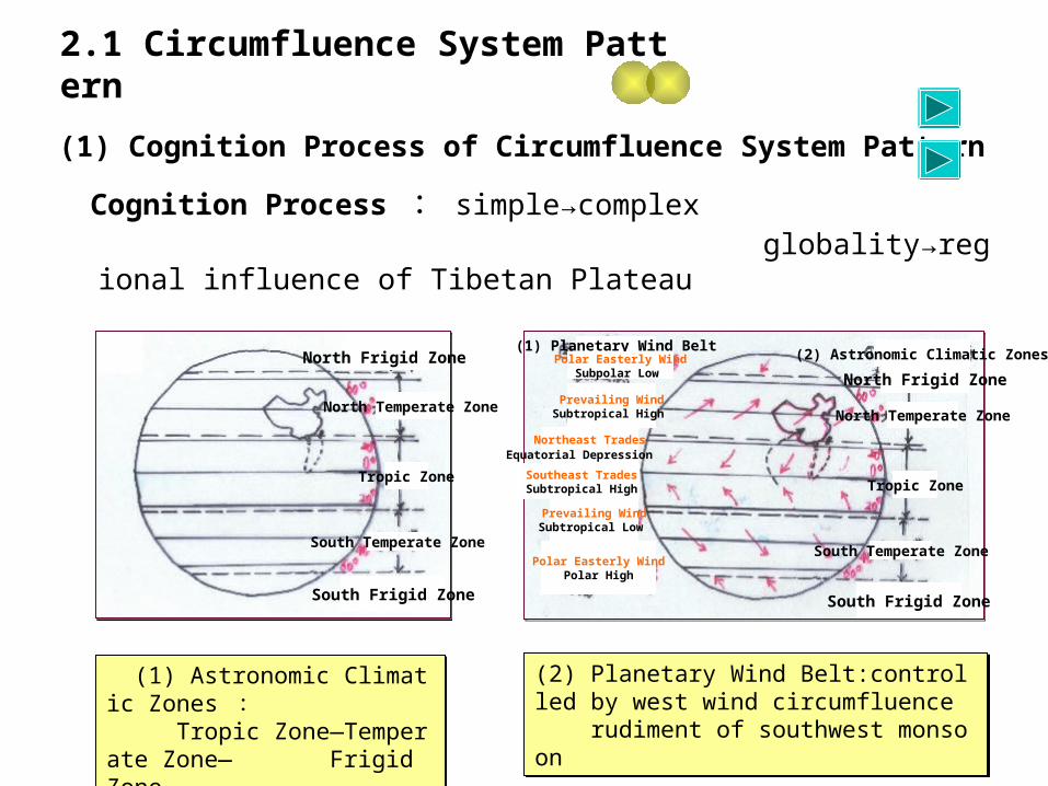
2.1 Circumfluence System Pattern
(1) Cognition Process of Circumfluence System Pattern
Cognition Process : simple→complex globality→regional influence of Tibetan Plateau
(1) Astronomic Climatic Zones : Tropic Zone—Temperate Zone— Frigid Zone
(1) Astronomic Climatic Zones : Tropic Zone—Temperate Zone— Frigid Zone
(2) Planetary Wind Belt:controlled by west wind circumfluence rudiment of southwest monsoon
(2) Planetary Wind Belt:controlled by west wind circumfluence rudiment of southwest monsoon
North Frigid Zone
North Temperate Zone
Tropic Zone
South Temperate Zone
South Frigid Zone
(1) Planetary Wind Belt
North Frigid Zone
North Temperate Zone
Tropic Zone
South Temperate Zone
South Frigid Zone
(2) Astronomic Climatic ZonesPolar Easterly WindSubpolar Low
Prevailing WindSubtropical High
Northeast TradesEquatorial Depression
Southeast TradesSubtropical High
Prevailing WindSubtropical Low
Polar Easterly WindPolar High
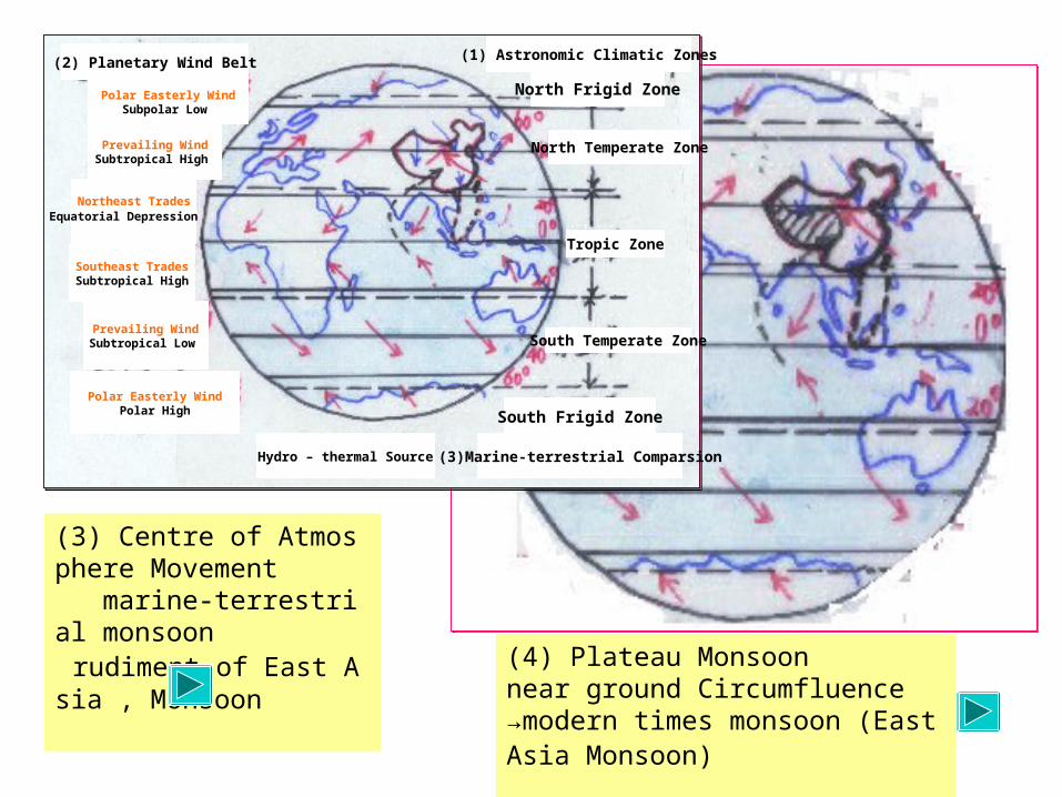
(3) Centre of Atmosphere Movement marine-terrestrial monsoon rudiment of East Asia , Monsoon (4) Plateau Monsoon
near ground Circumfluence →modern times monsoon (East Asia Monsoon)
(2) Planetary Wind Belt
North Frigid Zone
North Temperate Zone
Tropic Zone
South Temperate Zone
South Frigid Zone
(1) Astronomic Climatic Zones
Polar Easterly WindSubpolar Low
Prevailing WindSubtropical High
Northeast TradesEquatorial Depression
Southeast TradesSubtropical High
Prevailing WindSubtropical Low
Polar Easterly WindPolar High
(3)Marine-terrestrial ComparsionHydro – thermal Source
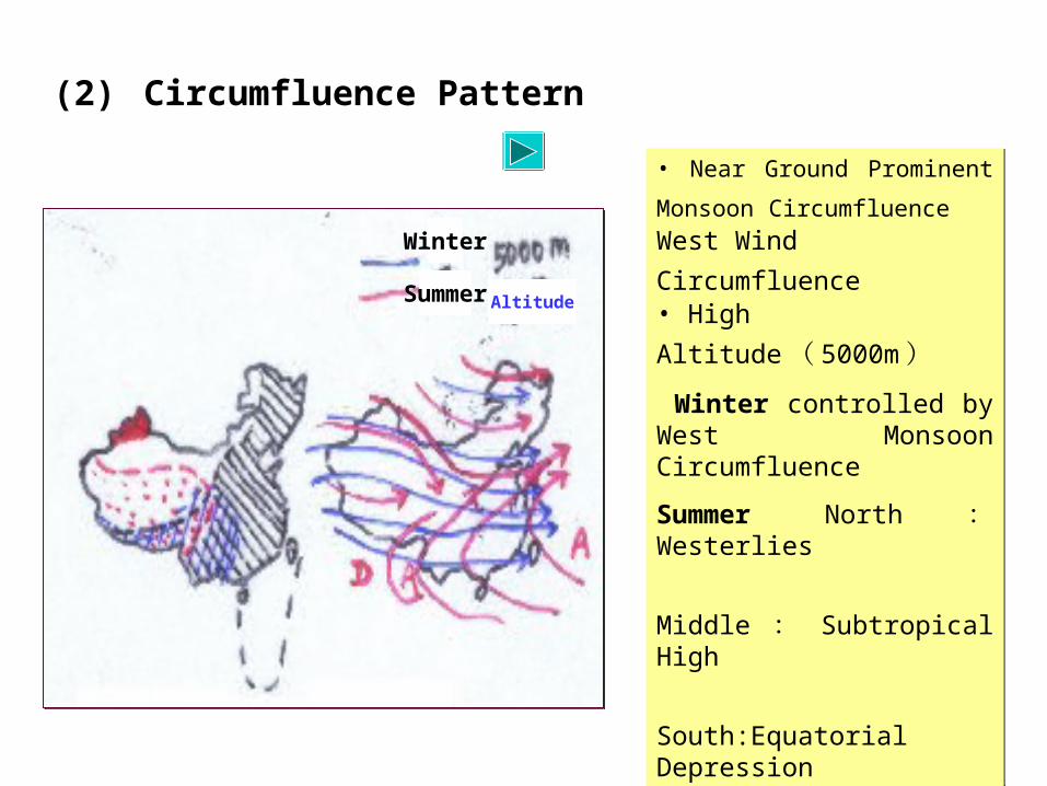
(2) Circumfluence Pattern
• Near Ground Prominent Monsoon
Circumfluence West Wind Circumfluence • High Altitude ( 5000m ) Winter controlled by West Monsoon Circumfluence
Summer North : Westerlies
Middle : Subtropical High
South:Equatorial Depression
• Near Ground Prominent Monsoon
Circumfluence West Wind Circumfluence • High Altitude ( 5000m ) Winter controlled by West Monsoon Circumfluence
Summer North : Westerlies
Middle : Subtropical High
South:Equatorial Depression
Winter
Summer Altitude
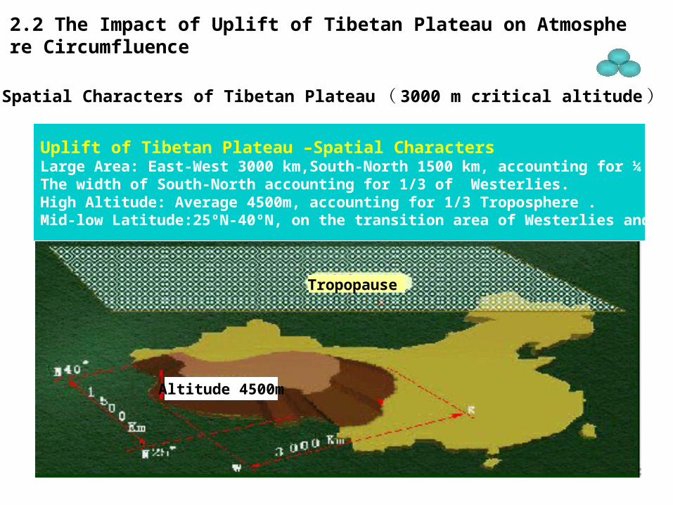
2.2 The Impact of Uplift of Tibetan Plateau on Atmosphere Circumfluence
(1) Spatial Characters of Tibetan Plateau ( 3000 m critical altitude )
Uplift of Tibetan Plateau –Spatial CharactersLarge Area: East-West 3000 km,South-North 1500 km, accounting for ¼ of land area of China,The width of South-North accounting for 1/3 of Westerlies.High Altitude: Average 4500m, accounting for 1/3 Troposphere .Mid-low Latitude:25ºN-40ºN, on the transition area of Westerlies and Subtropical High.
Tropopause
Altitude 4500m
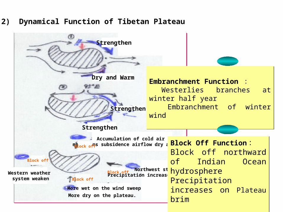
Embranchment Function : Westerlies branches at winter half year Embranchment of winter wind
Embranchment Function : Westerlies branches at winter half year Embranchment of winter wind
(2) Dynamical Function of Tibetan Plateau
Dry and Warm
Strengthen
Strengthen
Strengthen
Accumulation of cold air maintains subsidence airflow dry and cold.Block off
Block off
Block off
Block offWestern weather system weaken
Northwest stretches,Precipitation increases on Plateau brim
More wet on the wind sweep
More dry on the plateau.
Block Off Function :Block off northward of Indian Ocean hydrospherePrecipitation increases on Plateau brim
Block Off Function :Block off northward of Indian Ocean hydrospherePrecipitation increases on Plateau brim
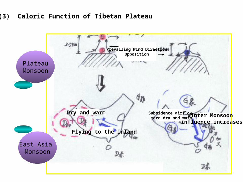
(3) Caloric Function of Tibetan Plateau
PlateauMonsoon
East Asia Monsoon
Prevailing Wind DirectionOpposition
Flying to the inland
Dry and warm Winter Monsoon Influence increases
Subsidence airflow more dry and warm
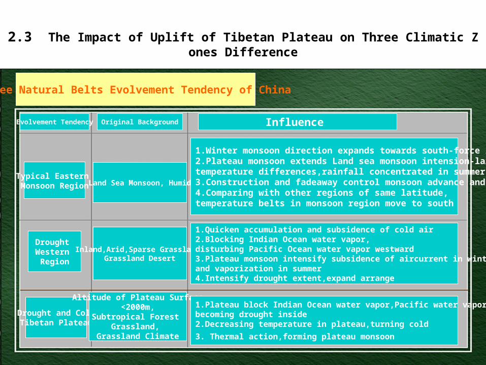
2.3 The Impact of Uplift of Tibetan Plateau on Three Climatic Zones Difference
Three Natural Belts Evolvement Tendency of China
Evolvement Tendency Original Background Influence
Typical Eastern Monsoon Region
Drought Western Region
Drought and ColdTibetan Plateau
Land Sea Monsoon, Humid
Inland,Arid,Sparse Grassland,Grassland Desert
Altitude of Plateau Surface<2000m,
Subtropical Forest Grassland,
Grassland Climate
1.Winter monsoon direction expands towards south-force increasing2.Plateau monsoon extends Land sea monsoon intension-large annual temperature differences,rainfall concentrated in summer3.Construction and fadeaway control monsoon advance and retreat4.Comparing with other regions of same latitude,temperature belts in monsoon region move to south
1.Quicken accumulation and subsidence of cold air2.Blocking Indian Ocean water vapor,disturbing Pacific Ocean water vapor westward3.Plateau monsoon intensify subsidence of aircurrent in winter and vaporization in summer4.Intensify drought extent,expand arrange
1.Plateau block Indian Ocean water vapor,Pacific water vapor,becoming drought inside2.Decreasing temperature in plateau,turning cold
3. Thermal action,forming plateau monsoon
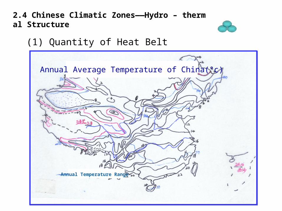
2.4 Chinese Climatic Zones——Hydro – thermal Structure
(1) Quantity of Heat Belt
Annual Average Temperature of China(°c)
Annual Temperature Range
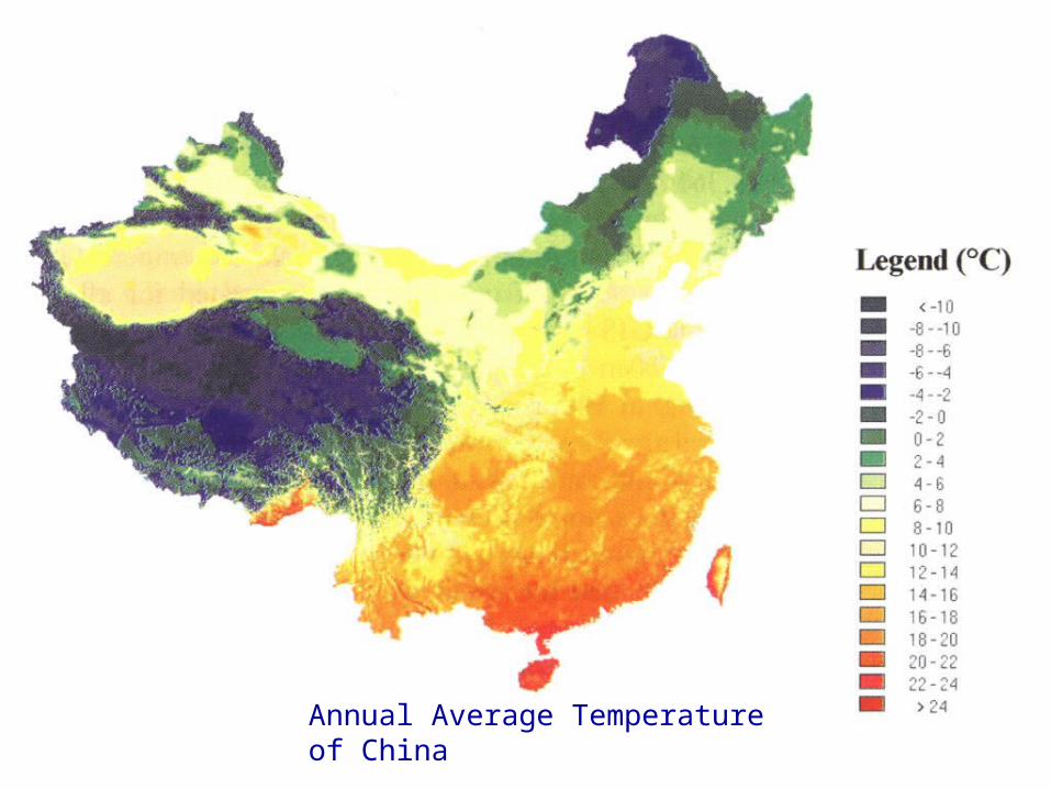
Annual Average Temperature of China
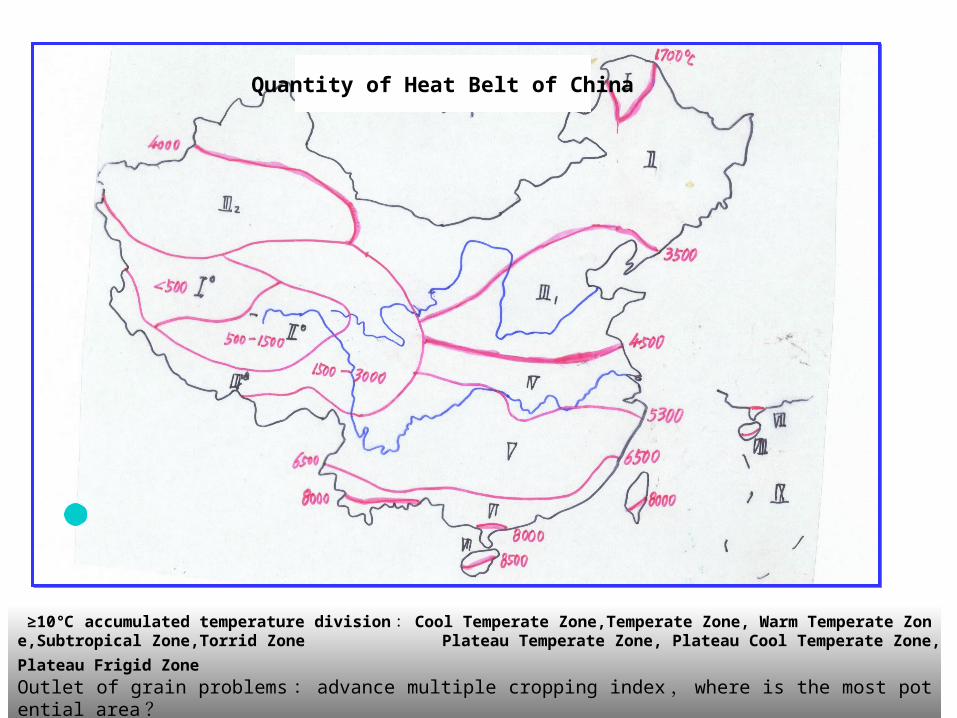
≥10 accumulated temperature division℃ : Cool Temperate Zone,Temperate Zone, Warm Temperate Zone,Subtropical Zone,Torrid
Zone Plateau Temperate Zone, Plateau Cool Temperate Zone,Plateau Frigid Zone Outlet of grain problems : advance multiple cropping index , where is the most potential area ?
Quantity of Heat Belt of China
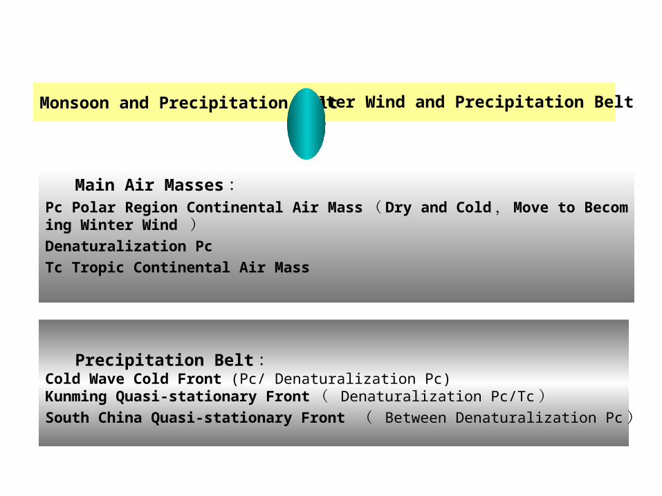
Main Air Masses :Pc Polar Region Continental Air Mass ( Dry and Cold , Move to Becoming Winter Wind )Denaturalization Pc
Tc Tropic Continental Air Mass
Monsoon and Precipitation Belt
Precipitation Belt :Cold Wave Cold Front (Pc/ Denaturalization Pc)Kunming Quasi-stationary Front ( Denaturalization Pc/Tc ) South China Quasi-stationary Front ( Between Denaturalization Pc )
Winter Wind and Precipitation Belt
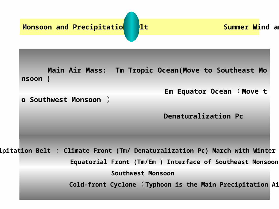
Main Air Mass: Tm Tropic Ocean(Move to Southeast Monsoon )
Em Equator Ocean ( Move to Southwest Monsoon )
Denaturalization Pc
Monsoon and Precipitation Belt Summer Wind and Precipitation Belt
Precipitation Belt : Climate Front (Tm/ Denaturalization Pc) March with Winter Monsoon
Equatorial Front (Tm/Em ) Interface of Southeast Monsoon and
Southwest Monsoon
Cold-front Cyclone ( Typhoon is the Main Precipitation Airflow )

Average of the Whole Country : 629mm Taking drought axis as center to southeast 50-4000mm ( 80 times )to northwest 50-400mm ( 8 times ) Three Important Isolines : 800mm 400mm 250mm
Average of the Whole Country : 629mm Taking drought axis as center to southeast 50-4000mm ( 80 times )to northwest 50-400mm ( 8 times ) Three Important Isolines : 800mm 400mm 250mm
Annual Average Precipitation
To Kexun
Huo Shaoliao
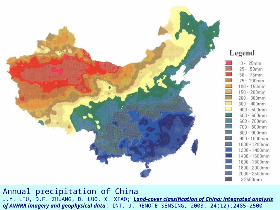
Annual precipitation of ChinaJ.Y. LIU, D.F. ZHUANG, D. LUO, X. XIAO; Land-cover classification of China: integrated analysis of AVHRR imagery and geophysical data; INT. J. REMOTE SENSING, 2003, 24(12):2485-2500
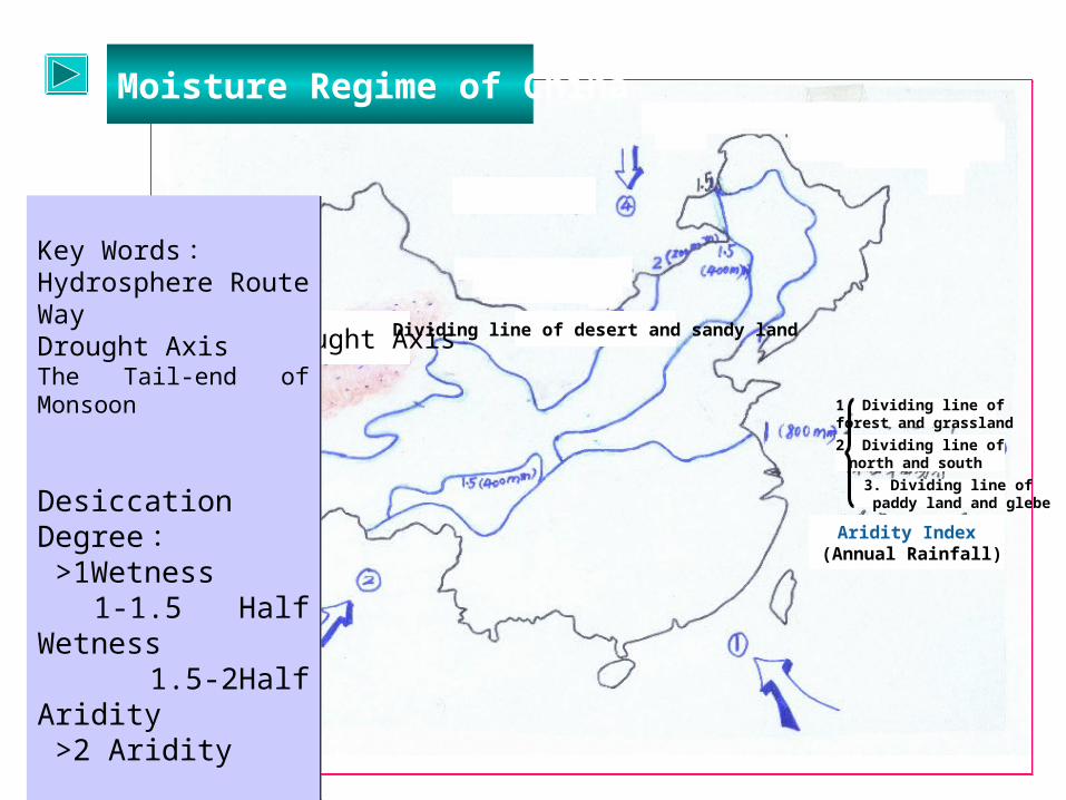
Moisture Regime of China
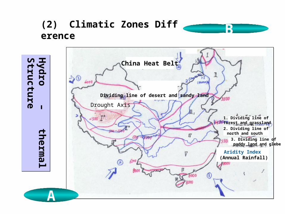
Drought Axis Dividing line of desert and sandy land
Aridity Index (Annual Rainfall)
1. Dividing line of forest and grassland
3. Dividing line of paddy land and glebe
2. Dividing line ofnorth and south
Key Words : Hydrosphere Route WayDrought AxisThe Tail-end of Monsoon
Desiccation Degree : >1Wetness 1-1.5 Half Wetness 1.5-2Half Aridity >2 Aridity
Landscape and Agriculture
Key Words : Hydrosphere Route WayDrought AxisThe Tail-end of Monsoon
Desiccation Degree : >1Wetness 1-1.5 Half Wetness 1.5-2Half Aridity >2 Aridity
Landscape and Agriculture
Hyd
ro – therm
al Stru
cture
Hyd
ro – therm
al Stru
cture
(2) Climatic Zones Difference
A
A B
China Heat Belt
Dividing line of desert and sandy land
Aridity Index (Annual Rainfall)
1. Dividing line of forest and grassland
3. Dividing line of paddy land and glebe
2. Dividing line ofnorth and south
Drought Axis
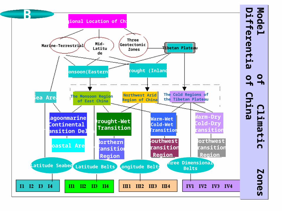
Regional Location of China
Marine-Terrestrial Mid-Latitude
Three Geotectonic
Zones Tibetan Plateau
Sea Area
Monsoon(Eastern) Drought (Inland)
The Monsoon Region of East China
Northwest Arid Region of China
The Cold Regions of the Tibetan Plateau
Lagoonmarine-Continental
Transition Delta
Drought-Wet Transition
Coastal AreaNorthern
Transition Region
Southwest Transition
Region
Northwest Transition
Region
Warm-Wet Cold-Wet Transition
Warm-Dry Cold-Dry Transition
Latitude Seabed Latitude Belts Longitude BeltsThree Dimensional
Belts
Mod
el of Clim
atic Zon
es Differen
tia of Ch
ina
Mod
el of Clim
atic Zon
es Differen
tia of Ch
ina
B
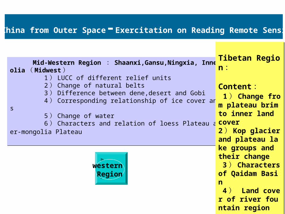
Mid-Western Region : Shaanxi,Gansu,Ningxia, Inner-Mongolia ( Midwest ) 1 ) LUCC of different relief units 2 ) Change of natural belts 3 ) Difference between dene,desert and Gobi 4 ) Corresponding relationship of ice cover and oasis 5 ) Change of water 6 ) Characters and relation of loess Plateau and inner-mongolia Plateau
Mid-Western Region : Shaanxi,Gansu,Ningxia, Inner-Mongolia ( Midwest ) 1 ) LUCC of different relief units 2 ) Change of natural belts 3 ) Difference between dene,desert and Gobi 4 ) Corresponding relationship of ice cover and oasis 5 ) Change of water 6 ) Characters and relation of loess Plateau and inner-mongolia Plateau
01 中国地理 · 第二章
Tibetan Region :
Content : 1 ) Change from plateau brim to inner land cover 2 ) Kop glacier and plateau lake groups and their change 3 ) Characters of Qaidam Basin 4 ) Land cover of river fountain region 5 ) Contrast of 4 plateaus of China
Tibetan Region :
Content : 1 ) Change from plateau brim to inner land cover 2 ) Kop glacier and plateau lake groups and their change 3 ) Characters of Qaidam Basin 4 ) Land cover of river fountain region 5 ) Contrast of 4 plateaus of China
Look at China from Outer Space-Exercitation on Reading Remote Sensing Image
western Region
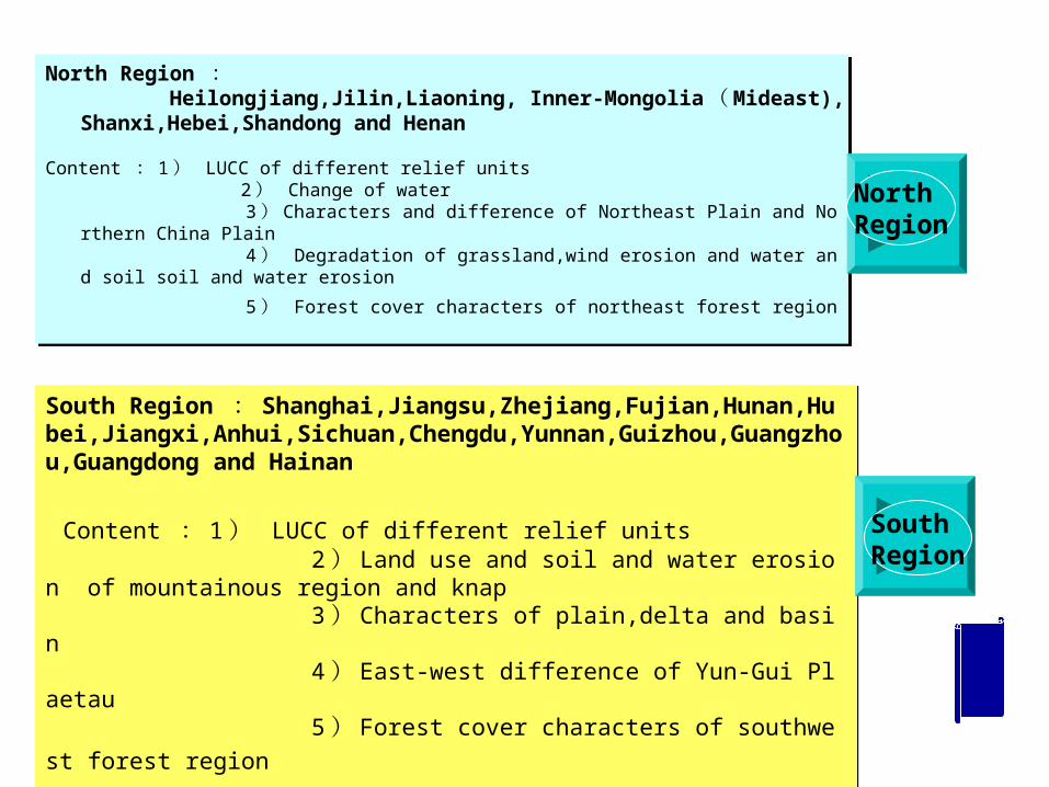
North Region : Heilongjiang,Jilin,Liaoning, Inner-Mongolia ( Mideast),Shanxi,Hebei,S
handong and Henan
Content : 1 ) LUCC of different relief units 2 ) Change of water 3 ) Characters and difference of Northeast Plain and Northern China Plain 4 ) Degradation of grassland,wind erosion and water and soil soil and water erosio
n
5 ) Forest cover characters of northeast forest region
01 中国地理 · 第二章
South Region : Shanghai,Jiangsu,Zhejiang,Fujian,Hunan,Hubei,Jiangxi,Anhui,Sichuan,Chengdu,Yunnan,Guizhou,Guangzhou,Guangdong and Hainan
Content : 1 ) LUCC of different relief units 2 ) Land use and soil and water erosion of mountainous region and knap 3 ) Characters of plain,delta and basin 4 ) East-west difference of Yun-Gui Plaetau
5 ) Forest cover characters of southwest forest region
North Region
South Region