19th meeting - ozcoasts.org.au
TRANSCRIPT

19th Meeting 30th Nov – 2nd Dec, 2010 Sydney
H o s t e d b y : N S W D e p a r t m e n t o f E n v i r o n m e n t , C l i m a t e C h a n g e & Wa t e r
Organisers and Conveners: Kerryn Stephen: NSW Department of Environment, Climate Change & Water (02) 4224-4156; Mob: 0428-261-826
Jaimie Potts: NSW Department of Environment, Climate Change & Water (02) 9995- 5642; (M) 0434350234 Lynda Radke: Geoscience Australia (Canberra) (02) 6249 9237; Mob: 0428 422 970
Attendees: NSW Tim Pritchard NSW Dept. of Environment, Climate Change & Water
Kerryn Stephens NSW Dept. of Environment, Climate Change & Water
Peter Scanes NSW Dept. of Environment, Climate Change & Water
Jaimie Potts NSW Dept. of Environment, Climate Change & Water
Geoff Coade NSW Dept. of Environment, Climate Change & Water
Tony Roper NSW Dept. of Environment, Climate Change & Water
Bob Creese Industry & Investment NSW - Fisheries
Angus Ferguson NSW Dept. of Environment, Climate Change & Water
Renee Gruber NSW Dept. of Environment, Climate Change & Water
Victoria Jeremy Hindell Vic. Department of Sustainability & Environment
Queensland Dawn Couchman Qld Dept of Employment, Economic Development & Innovation
Tasmania Christine Coughanowr Tas. Dept. of Primary Industries, Parks, Water & Envt.
Christine Crawford Tas. Aquaculture and Fisheries Institute
Jeff Ross Tas. Aquaculture and Fisheries Institute
Jan Tilden University of Tasmania
NT Julia Fortune
NT Dept. of Natural Resources, Environment the Arts and Sport (via phone hook-up; 08-8999-3487/0459812751)
WA Catherine Thomson WA Dept. of Water
Vanessa Forbes WA Dept. of Water

Malcolm Robb WA Dept. of Water
Shaun Meredith Swan River Trust
National Lynda Radke Geoscience Australia
Andrew Heap Geoscience Australia
Arnold Dekker CSIRO Land & Water
Chris Rees ICAG
Ian Cresswell CSIRO Wealth from Oceans National Research Flagship
Simon Allen CSIRO Wealth from Oceans National Research Flagship
International Mike Kemp University of Maryland
Tuesday 30th November, 2010 Tuesday 30th Nov, 2010
National Estuaries Network Meeting Level 15 Conference Room, DECCW Offices, 59-61 Goulburn Street
8:20 Meet 8:20 am in front of Meriton Apartments for short walk (5 min) to meeting venue. 8:30 – 9:00 Tea, Coffee and settle in 9:00 – 9:05 9:05 – 9:15
Mike Sharpin, Manager Urban and Coastal Water Strategy Welcome Lynda Radke/Kerryn Stephens & Jaimie Potts: Apologies, introductions & housekeeping
9:15 – 10:30 State/Territory Roundtable Update (Each State/item – up to 15 min; Chair: Lynda Radke) What’s happening with respect to estuary management in Australia - each state and national rep to give brief overview of estuary management in their jurisdiction.
o NSW update (Peter Scanes) o NT update (phone hook-up: Julia Fortune) o SA update (comments on report) o WA update (Malcolm Robb) o TAS update (Christine Coughanowr/Christine Crawford) o Special Item: Coastal Observatory Workshop (CTC 2010) (Tim Pritchard)
10:30 – 11:00 MORNING TEA 11:00 – 1:00 Continue with State Roundtable update
o QLD update (Dawn Couchman) o VIC update (Jeremy Hindell) o ICAG update (Chris Rees) o CSIRO update (Arnold Dekker) o GA update: (Lynda Radke) o Special item: AMSA symposium; Framework for Assessment of River and
Wetland Health (Malcolm Robb) o Next meeting, rationalise mailing list & other general discussion
1:00– 2:00 LUNCH 2:00 – 3:30 Chair: Peter Scanes:
o Workshop objectives (see workshop information) o Existing conceptual models
o National set of models o Gaps in models
3:30 – 4:00 AFTERNOON TEA 4:00 – 5.00 o Workshop continued
5:00 – 6:30 Free time 7 pm – late NEN Dinner
Sumac Restaurant & Bar, Shop 284, The Promenade, Harbourside Shopping Cntr Darling Harbour

National Estuaries Network (NEN) Science Symposium Program: Time Venue Session Chair Speaker Organisation Presentation Title8:15 am Registration 8:50 am Theatre Welcome Dr Kate Wilson NSW DECCW 9:00 am Theatre Keynote Dr Klaus Koop Prof Mike Kemp University of
Maryland Degradation and restoration of coastal ecosystems: A case study of Chesapeake Bay
10:00 am Theatre Prof Michael Keough University of Melbourne
Engineering ecological resilience in the sea
10:20 am Dr Bob Creese I & I NSW Estuarine habitat destruction 10:40 am The Terrace Morning tea 11:10 am Theatre Dr Klaus Koop Mr David Hanslow
NSW DECCW Coastal lake entrances and climate change
11:30 am Theatre Prof Maria Byrne University of Sydney
Impacts of climate change on marine invertebrate life histories
11:50 am Theatre Dr Kerry-Lee Rogers NSW DECCW Assessing the vulnerability of saline coastal wetlands to sea-level rise
12:10 pm Theatre Dr Angus Ferguson NSW DECCW Estuarine ecological response models to predict effects of climate change and eutrophication
12:30 pm The Terrace Lunch 1:30 pm Theatre Mr Tim Pritchard Dr Anthony Roach
NSW DECCW Organic micro-pollutants in our estuaries
1:50 pm Theatre Dr Brendan Kelaher Batemans Bay Marine Park
Importance of top down predation in marine park sanctuary zones
2:10 pm Theatre Dr Emma Johnson UNSW Who is sensitive to what?: assessing and understanding ecological changes in highly disturbed estuaries
2:30 pm Theatre Professor Ian Suthers UNSW Water quality and the unappreciated roles of zooplankton, benthic grazers and mangrove habitat for mussels
2:50 pm The Terrace Afternoon Tea 3:20 pm Theatre Dr Peter Scanes Dr Doug Rotherham I & I NSW Surveys of estuarine fisheries resources in NSW: who, what,
why, where, when and how? 3:40 pm Theatre Dr Marcus Lincoln-Smith Cardno Challenges and needs for Environment Impact Assessment in
estuaries 4:00 pm Theatre Mr. Scott Carter I&I NSW and
NSW DECCW Gaps in science knowledge in an estuarine context: management needs and policy making in NSW.
4:20 pm Theatre Discussion Dr Peter Scanes Questions from floor 5:00 pm Skeleton Room Drinks 6:00 pm Close

Meeting No. 19 Sydney, NSW
30 Nov, 2010
AGENDA PAPER State / Territory: Special Item
19th National Estuary Network Meeting, Sydney NSW: State Summaries
Prepared by: Ian Cresswell Position: Science Director Organisation: CSIRO Wealth from Oceans National Research Flagship, CSIRO Marine and Atmospheric Research A NATIONAL APPROACH TO A MONITORING, EVALUATION & REPORTING (MER)
FRAMEWORK under the NRM Marine and Coastal Committee (MACC) In 2008 the Natural Resources Management Ministerial Council (NRMMC) released a report on Marine Biodiversity Decline in Australia, which, among other things, recommended all jurisdictions “Work towards a nationally consistent marine and coastal biodiversity and fisheries monitoring and reporting framework with baseline / reference sites in and out of Marine Protected Areas”. As a consequence the MACC instructed its R&D working group to develop a national approach to MER as one of its Terms of Reference, and identified this as the highest priority for its work plan. In July 2009 the MACC R&D working group convened a 2 day workshop to scope the need, current activity and potential for a national approach to MER in estuarine, coastal and marine environments. The workshop strongly endorsed a national approach, with identified benefits including: a) More effective management of marine systems that cross jurisdictional boundaries b) Greater alignment between fisheries and conservation, supporting ecosystem based management c) More efficient and effective use of data e.g. for state/territory reporting and for national reports such as SoE d) Potential for widely available data sets that can be used for broader research objectives e) Ability to leverage and learn from work undertaken in other jurisdictions. The workshop further recommended development of a Common Assessment and Reporting Framework and a set of pilot studies to progress meaningful evaluation of the benefits of and pathways to a national approach. Consequently the MACC endorsed the formation of a taskforce reporting to the R&D working group to progress this work. The R&D WG MER taskforce developed a Common Assessment and Reporting Framework to guide development and use of MER applications in a nationally consistent manner, compatible with approaches being adopted in all jurisdictions, which was endorsed by the NRMMC. The taskforce also ran four pilot studies to further develop and demonstrate the efficacy of the national approach.
5

Furthermore MACC has agreed to promote the CARF as best practice management and to apply it to MER programs in marine, coastal and estuarine environments in MACC member departments where there is agreement on the requirement for national and cross-jurisdictional scale reporting, such as in State of the Environment reporting, and ecosystem based management (including alignment with ecosystem based fisheries management). This initiative links closely to the National Plan for Environmental Information (NPEI) which will produce the National Environmental Information System (NEIS). It is anticipated the data generated via the CARF could feed directly into the NEIS and that the MER activity will be integral to the eventual national development and implementation of the NEIS.
Meeting No. 19 Sydney, NSW
30 Nov, 2010
AGENDA PAPER State / Territory: NSW Prepared by: Dr Peter Scanes / Kerryn Stephens Position: Organisation: Department of Environment, Climate Change and Water.
Update – Estuary Management • The Coastal Protection and Other Legislation Amendment Act 2010 has been passed by the
NSW Parliament, the majority of the Act's amendments are expected to commence on 1 January 2011. The Act will amend the Coastal Protection, Local Government and Environmental Planning and Assessment Acts, and three regulations. The primary objective of the Act is to improve the arrangements for managing coastal erosion risks. The Act also improves arrangements for coastal zone management planning, including coastal climate change adaptation and management of estuary health. Specifically, Section 55C (Matters to be dealt with in coastal zone management plans) has been amended and now includes:
A coastal zone management plan must make provision for: e) where the plan relates to an estuary, the management of estuary health and any risks to the
estuary arising from coastal hazards, and f) the impacts from climate change on risks arising from coastal hazards and on estuary health,
as appropriate. • To support the amended Coastal Protection Act, Guidelines for preparing coastal zone
management plans, are being prepared. These statutory Minister's guidelines will specify the requirements for councils preparing coastal zone management plans under the Act. The guidelines will include minimum community consultation requirements and how projected climate change impacts are to be considered when preparing plans. For plans prepared for estuaries, the guidelines will outline how estuary health is to be assessed and how appropriate management actions can be identified to minimise risks to estuary health. DECCW is hoping to release the final version of the guidelines by 1 January 2011. These guidelines will replace the 1990 Coastline Management Manual and the 1992 Estuary Management Manual.
6

Update – Estuary Research
• New projects focussing on improving representations of seagrass growth/survival in existing ecological response models and building links between primary producers and estuarine food webs using stable isotope techniques.
• Finalised report on ecological process indicators. These new indicators how promise in discriminating when “abundance” indicators show no difference.
• Continuing State-wide chlorophyll and turbidity monitoring – 30 estuaries this summer.
• Developed a nutrient assimilation “box-model” for upper-middle Hawkesbury River estuary
• CERAT web development still underway.
• Release of the State of the Catchments Reports (Estuaries) is imminent. The reports provide an initial condition assessment for 100 of the 184 estuaries identified in NSW and a pressure assessment for all 184 estuaries. The technical documentation that supports the reports will also be released.
Meeting No. 19 Sydney, NSW
30 Nov, 2010
AGENDA PAPER State / Territory: Northern Territory Prepared by: Julia Fortune and John Drewry Position: Manager, Scientist Organisation: Department of Natural Resources, Environment, The Arts and Sport
1. Update – Estuary Management Beaches and monitoring • Between June and October 2010 bacterial counts above guideline levels and presence of
nuisance blooms led to beach closures for several of Darwin’s beaches. Investigations into all of the sources of the high bacterial counts are ongoing. Microbiological monitoring of beach waters and four tidal creeks is continuing.
• A bloom of Lyngbya majuscula occurred in Darwin Harbour in May–June 2010, as in other years. Water quality samples and algal samples have been collected in 2010 to help build knowledge of the bloom and water quality associated with it.
• The treatment plant mixing zone areas at several STP outfalls commenced independent monitored by the Aquatic Health Unit at fortnightly intervals from mid to late 2010. Additional monitoring is undertaken by Power and Water Corporation during alternate intervals.
Other monitoring and information • Water quality objectives were declared in July 2010 under the Water Act providing legislative
credence to these objectives as regulatory and monitoring performance benchmarks. Quite an achievement for the group.
• The second set of report cards produced on the health of Darwin Harbour and its catchment will be released in late November or early December.
• The Darwin Harbour Integrated Monitoring and Research Plan is a comprehensive monitoring plan that is being progressed in the Department to assess the on-going health of the Harbour.
7

8
• Monitoring at quarterly intervals at an additional seven estuarine sites has commenced in mid 2010 to improve and expand on monitoring efforts.
• A considerable amount of data from recent years and in 2010 has been analysed and written up as reports. The AHU will soon release four reports on water quality in the Darwin Harbour region.
• A proposal is being developed to further monitor tidal creeks in partnership with Larrakia Sea Rangers.
Water Quality Protection Plan • An integrated decision support system will be developed for Darwin Harbour catchment to
improve understanding of the effect of various processes and potential developments on water quality in the catchment. This will enable completion of the Water Quality Protection Plan under a successful Caring for our Country application. The WQPP will include: a revision of selected water quality objectives; identification of pollutant sources and targets; recommended management measures; processes for ongoing adaptive management and public involvement and reporting. Larrakia people will also be engaged to incorporate Indigenous values in communication products and undertake scientific monitoring.
2. Update – Estuary Research • Plans for research with CDU are being progressed investigating the impact of sewage effluent
on the microbial community in macro-tidal tropical creeks and identifying microbial functional genes at impacted and reference sites
• There is ongoing monitoring and research into flood plume water quality and distribution of water quality indicators in the Elizabeth River estuary. Catchment data are being collected this wet season as well to integrate knowledge of the catchment and estuarine systems.
• Phytoplankton identification has commenced on a monthly monitoring basis in the Elizabeth River estuary.
• Coastal dolphins research in Darwin Harbour and coast of NT: Since February 2008, two semi-enclosed harbours (Darwin Harbour and Port Essington, Cobourg) in the Northern Territory have been regularly surveyed for 3 species of coastal dolphins (Australian snubfin Orcaella heinsohni; Indo-Pacific humpback Sousa chinensis, Indo-Pacific bottlenose Tursiops aduncus) . To date, data suggest that the 3 species occur in low numbers, there are resident populations at both sites and to varying degrees are reliant on coastal, estuary and tidal river habitats. Data analysis and writing-up is currently being undertaken. Monthly surveys of the West Alligator River (the only river in the NT where recreational fishing is banned along with commercial fishing) and the Wildman River in Kakadu National Park is currently being undertaken and follows on from early surveys (2007 to 2008) of the South and East Alligator Rivers. Two species of coastal dolphins (Australian snubfin and Indo-Pacific humpback) are regularly recorded from 30 to 50km upstream in the tidal rivers, expanding on preconceived notions of coastal dolphin habitat. • Collaborative bioindicator pilot project is continuing across Darwin Harbour with a focus on
shellfish and mudcrabs. Accumulation of metals, toxicants and EDC’s in shellfish of cultural significance has continued to be the focus of this work undertaken by AIMS, Charles Darwin University, NRETAS and Larrakia Sea Rangers.
3. Significant Issues for Discussion We would be grateful for feedback and suggestions on: • Suggestions for investigations into all of the sources of the high bacterial counts associated
with beaches and tidal creeks, and lessons learned from previous experience in other states.

• Lessons learned from previous experience completing WQIPs, especially from an estuarine perspective.
• Lack of data/knowledge of estuaries outside Darwin Harbour • Need for habitat mapping • There is a need to develop knowledge and policy associated with large dredging projects.
Meeting No. 19 Sydney, NSW
30 Nov, 2010
AGENDA PAPER State / Territory: South Australia Prepared by: Peter Pfenig Position: Manager, Port River Projects Organisation: EPA Update – Estuary Management EPA is progressing the Adelaide Coastal Water Quality Improvement Plan. Update – Estuary Research EPA has been undertaking event based sampling of coastal discharges and intend to progress a conceptual model of suspended solids and coloured dissolved organic matter and pathogens in the next six months. Prepared by: Martine Kinloch Position: Coast & Marine Program Manager Organisation: KI NRM Board
Update – Estuary Management • On-ground works funded by the KI NRM Board in the Cygnet River catchment .are being
targeted around improving water quality in the Cygnet River, thereby benefiting estuarine and marine ecosystem health downstream. The placement of OGW is being driven through a catchment model for the Cygnet River developed by the EPA in partnership with KI NRM Board.
• A network of flow meters, gauging stations and composite samplers is currently being established both for the Cygnet River and the Island as a whole, as part of a comprehensive water monitoring system on KI. In situ water sampling will also occur.
Update – Estuary Research • Judith Wingate-Giraldo’s PhD research into Black Bream (Linking fish recruitment and habitat
use to ecosystem processes) continues, with fish and water sampling in eight KI estuaries and analysis of otolith chemistry and water quality. This project is funded through an ARC Linkage grant partnering Adelaide University with the KI NRM Board. The focus of research is on estuarine connectivity and ecosystem drivers of recruitment variability in fish populations.
Significant Issues for Discussion 9
• Sources of funding for research and monitoring. • Monitoring plans/frameworks.
Meeting No. 19 Sydney, NSW
30th Nov 2010
AGENDA PAPER State / Territory: Western Australia Prepared by: Malcolm Robb (BM), Vanessa Forbes (EO), Catherine Thomson (EO), Chris Gunby (RM), Kirsty Alexander (EO), Tracy Calvert (EO), Kath Lynch (RM) Position: Branch Manager (BM), Regional Managers (RM), Environmental Officers (EO) Organisation: Department of Water (Perth, Busselton, Albany-WA)
4. Update – Estuary Management
The Water quality improvement plan for the Leschenault Estuary (Bunbury, WA) and Hardy Inlet (Augusta, WA) are nearing completion. The document has been developed in accordance with the Framework for Marine and Estuarine Water Quality Protection. The Department of Water (Water Science Branch) has had particular involvement in the analysis of water quality data and the modelling the delivery of nutrients to the estuaries. 5. Update – Estuary Research Swan-Canning Estuary Oxygenation programs - the Canning River has two oxygenation plants that have operated for the last decade and are an integral part of the long term management of the Kent Street weir pool in the upper Canning. There is a potential for a third plant at Hester Park. Both Hester Park and Nicholson Road Bridge have a record of long term low a dissolved oxygen concentrations. In November 2009 an application of Phoslock was carried from Masons Landing to Hester Park approx 1.5 km stretch. The Bridge St Guildford oxygenation plant was constructed in Sept. 2007. Due to complication it was not fully operational until Feb 2009 and was comprehensively tested until last autumn. The results from 2009 showed that the plant was able to oxygenate the water column up to 3.1 km but this distance may have been limited by the location of the sampling sites. The results for 2010 suggest the plant is able to influence a greater stretch of the river than first expected (greater than 5.0 km). A second site for another plant is currently under construction at Caversham Ave, Caversham. It is 5.1 km upstream from the Bridge St plant and is the same size. There is likely to be a nice over lap if this plant has the same range of influence as the Bridge St. It is hoped to be operational this summer. Sediment investigations - In April 2010 an investigation into whether the oxygenation plant was able to influence sediment/water interface chemistry was undertaken. This was made possible with a collaboration with MERC Inc. Full analysis of this data is not complete but preliminary results are encouraging. Further to these investigations future work will include:
10

11
1) Measurement of oxygen and redox micro profiles in sediment using a ‘benthic lander’ (apparatus used in April 2010 investigation.
2) Aerobic microbial assay measuring carbon utilisation as a way to assess effect of oxygen plant on
sediment microbial community functionality.
South and southwest coast estuaries Estuary condition reporting – the Water Science Branch is working on a variety of reporting tools to communicate to stakeholders on the condition of estuaries. Estuary condition report series – these are community targeted reports, each one focusing on an individual estuary. The reports bring together background and technical information on each estuary to inform and educate local communities of the processes and conditions in the estuary. The first of these reports is on the Hardy Inlet which is near completion; the second is on the Leschenault Estuary. The publication of these will tie in with the release of the WQIP for these systems. ASSETS reporting – The Assessment of Estuary Eutrophic Status (ASSETS) index is being applied to a number of south coast estuaries. This is being trialled for the purpose of comparing eutrophic status of WA estuaries, temporally and spatially. As the ASSETS model has been applied to numerous international sites it is useful for broad comparison and ranking of eutrophic condition. It was also used in the HCVAE study of Walpole-Nornalup Inlet (see below) as an assessment index of eutrophic status in a high conservation value estuarine ecosystem. High Conservation Value Aquatic Ecosystem (HCVAE) - the Water Science Branch has been involved in a HCVAE ‘proof of concept’ study. DEWHA contracted the DoW to trial the 2nd component of the Framework which is to develop and trial a methodology for the assessment and management of a HCVAE. The final draft report has been submitted to DEWHA (now the Department of Sustainability, Environment, Water, Population and Communities). Estuary sandbar openings – river flows in many catchments have been the lowest on record this year. This has put some focus on estuary bar management. There are ongoing issues regarding the Wilson Inlet bar. The bar management of Wilson Inlet falls under the Drainage Act and is in place to manage flooding of agricultural when water levels of the Inlet exceed a pre-determined level. Historically this has led to annual openings. Reduced flows and low water levels led to an ineffective opening in 2006 (inadequate flushing of nutrients, seagrass ‘collapse’, sand build-up in the delta and insufficient ocean exchange). Following a revision of the drainage model in 2006/7, a minimum water level for opening the bar was established. Consequently the bar was left closed in 2007 and has again not been opened this year due to low water levels. There has been a big push from different groups to open the bar (particularly birding groups). We are concentrating on working with the community to monitor and assess the various aspects of the inlet and surrounds which are affected by a non-opening and to test the drainage review model and look at the best outcome in a drying climate. The position and opening of the Hardy Inlet has also been an issue. The Shire proposed the ‘Hardy Inlet bar opening strategy’ to shift the opening to its ‘original’ position closer to the town with the aim of improving water quality and maintaining an opening. The opening over the years has migrated eastwards. Frequent low winter flows have favoured sediment deposition along the coast shifting the opening approximately 1.5 km east of Augusta. There has also been concern that it may close completely. The Shire/community has associated the decline in water quality in the inlet (particularly around Augusta) with the shift in the position of the opening. Our advice to the Shire (through a community and science workshop) was to focus efforts on reducing nutrient inputs from the catchment and septic tanks. The opening was unsuccessful, closing after a few days. The Irwin Inlet was breached but closed after a few weeks due to low river flows. The permanent opening of the Walpole-Nornalup Inlet opening is also being challenged by lowest flows on record for this year. Unlike the rest of the South Coast, the catchments of Stokes Inlet (near Esperance) had above average rainfall and river flow and the estuary opened naturally over winter.

Water quality monitoring – While funding for estuary monitoring is reduced from previous years. Funding has been secured to address priority estuary monitoring for the South and South West Coast. We have applied this to monitor those estuaries for which we have an estuary/catchment management plan or Water Quality Improvement Plan (or are likely to or have some other justification to monitor). This should allow us to report on condition and trends as well as address management plan actions where possible. Macrophyte and macroalgal sampling – The Marine and Freshwater Research Laboratory (Murdoch University) have been mapping the distribution of macrophytes and macroalgae in the Vasse Wonnerup estuary. Excessive macroalgal growth of have been reported in the Leschenault estuary and the Hardy Inlet (most likely a result of nutrient enrichment from fertilized gardens).
Meeting No. 19 Sydney, NSW
30 Nov, 2010
AGENDA PAPER Special Item: Coastal Observing Workshop Coast to Coast Conference 2010
Prepared by: Tim Pritchard Position: Manager Water and Coastal Sciences Organisation: NSW Department of Environment, Climate Change and Water
Background • NEN sponsored a workshop held on 22nd September 2010 as part of the Coast to Coast
Conference in Adelaide: “DO WE NEED AN AUSTRALIAN COASTAL OBSERVATORY?” • Ian Cresswell (CSIRO), Richard Mount (UTas), Tim Pritchard (DECCW) and Arnold Dekker
(CSIRO) organised the workshop which was chaired by Ian Cresswell. Presentations were made by: Roger Proctor (Integrated Marine Observing System - IMOS/AODN), Andy Steven (Terrestrial Ecosystem Research Network - TERN), Warwick McDonald (National Plan for Environmental Information - NPEI), Andrew Heap (OzCoasts/Geoscience Australia), Alicja Mosbauer & Greg Laughlin (Australian National Data Service - ANDS), Colin Creighton (Fisheries Research and Development Corporation - FRDC), Don Hough (Office of the Environmental Monitor, Victoria), and Bruce Harper (Systems Engineering Australia). • A summary of workshop findings and outcomes are provided here for information. Workshop Summary
What is a ‘Coastal Observatory’
‘Coastal’ straddles the area between terrestrial and oceanic environments (GOOS definition) – i.e. focus on coastline with fuzzy seaward and landward boundaries Proposed purpose of an Australian Coastal Observatory:
To capture past, present and future observations of the Australian coast and make them available to assist with addressing environmental, social and economic challenges.
To provide a “data and information commons” that supports multiple reuse of coastal observations.
12

13
‘Observatory’ is an “eye on the coast” i.e. data collection, information systems, analysis and models (not just measurements). It includes products for operational delivery (like BoM) not just data commons (like IMOS). Focus on credible sustained observations. Driven by need to manage peoples use of coastal environmental assets/resources: physical, chemical, biological observations related to ecosystem attributes (e.g. biodiversity, ecology, amenity, landscapes) to inform decisions related to human pressures (e.g. landuses, fisheries, extractive industries, etc.).
Proposed guiding principles and rationale for a ‘Coastal Observatory’
• Maximise returns on investment
o The value of the original investment in data collection is maximised when the data and information is pooled, stored and reused
• Support improved decision making
o Open discovery and access to data and information underpins the democratic process
• Grow our current understanding
o Knowledge of the coast will grow at a greater rate if there is greater access to data and information
• Continual improvement in data quality
o Increasing the spatial, temporal and thematic resolution where ever possible will enhance the value of the data
• Supporting the people in the future
o Many uses for the observations collected today will emerge in the future and are currently unknown
DISCUSSION SUMMARY What are our needs We need clarity on ‘why’ - user pull.
National Committee Coastal and Ocean Engineering. See Engineers Aust web site – research priorities updated in 2000: (http://www.engineersaustralia.org.au/shadomx/apps/fms/fmsdownload.cfm?file_uuid=3879E73E-D46A-D47A-5808-0B2CB81E2194&siteName=ieaust ). The document “At What Price Data?” (NCCOE, 1993) presents arguments for data capture.
OPSAG coastal workshop (& GOOS) will identify ‘phenomena of interest’. Similarly the May 2010 Wind and Wave Symposium may identify gaps

Presented material and discussion highlighted but did nt prioritise a range of issues/needs including:
• Climate Change Adaptation: coastal vulnerability assessments: e.g. shoreline erosion and inundation, security of critical infrastructure, conservation and invasive species as ‘natural’ species distributions change, etc.
• Reporting: SoE, Reporting against Natural Resource Management targets, Environmental Accounts, Carbon Accounts.
• Coastal zone management and Coastal Development: landuse planning for sustainable coastal ecosystems, habitat protection priorities, eutrophication & harmful algal blooms
• Conservation Management: living marine resources, changed species distribution (CAR)
• Natural Resource Management
• Emergency Management
Filling gaps
• Better access to existing data is necessary but not sufficient to meet needs (e.g. very little data on shoreline variability and trends)
• IMOS and TERN make extremely valuable contributions to coastal observing but IMOS excludes bays, estuaries and the coastline and TERN’s Australian Coastal Ecosystem Facility is by necessity limited in scope.
• Need to identify information needs (foundation data sets) that demand national approach – for example
Coastal elevations (D.E.Ms) – eg LidAR Earth observations of land cover, habitats and productivity – eg World View 2 satellite data Inshore wave climate
• Capacity for coastal data collection is limited in States, private sector projects don’t have a driver to deliver legacy data and academic data sets are often equally elusive.
What are our priorities • Consolidate principles and criteria for national coastal observing from which the rationale for National Coastal Observatory may fall out.
• Open access to maximise value of existing data streams and information – need to ensure data capture at end of projects!
• ID key information products
• Avoid regrettable missed opportunities – eg remote sensing
14
15
overpasses
• Seek better understanding of Federal priorities– plus local, regional and State needs
• Seek clarification of the relationships between the various coastal information systems and existing observing initiatives.
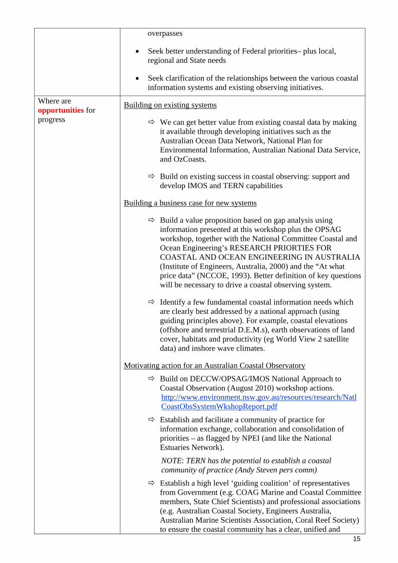
Where are opportunities for progress
Building on existing systems
We can get better value from existing coastal data by making it available through developing initiatives such as the Australian Ocean Data Network, National Plan for Environmental Information, Australian National Data Service, and OzCoasts.
Build on existing success in coastal observing: support and develop IMOS and TERN capabilities
Building a business case for new systems
Build a value proposition based on gap analysis using information presented at this workshop plus the OPSAG workshop, together with the National Committee Coastal and Ocean Engineering’s RESEARCH PRIORTIES FOR COASTAL AND OCEAN ENGINEERING IN AUSTRALIA (Institute of Engineers, Australia, 2000) and the “At what price data” (NCCOE, 1993). Better definition of key questions will be necessary to drive a coastal observing system.
Identify a few fundamental coastal information needs which are clearly best addressed by a national approach (using guiding principles above). For example, coastal elevations (offshore and terrestrial D.E.M.s), earth observations of land cover, habitats and productivity (eg World View 2 satellite data) and inshore wave climates.
Motivating action for an Australian Coastal Observatory
Build on DECCW/OPSAG/IMOS National Approach to Coastal Observation (August 2010) workshop actions. http://www.environment.nsw.gov.au/resources/research/NatlCoastObsSystemWkshopReport.pdf
Establish and facilitate a community of practice for information exchange, collaboration and consolidation of priorities – as flagged by NPEI (and like the National Estuaries Network).
NOTE: TERN has the potential to establish a coastal community of practice (Andy Steven pers comm)
Establish a high level ‘guiding coalition’ of representatives from Government (e.g. COAG Marine and Coastal Committee members, State Chief Scientists) and professional associations (e.g. Australian Coastal Society, Engineers Australia, Australian Marine Scientists Association, Coral Reef Society) to ensure the coastal community has a clear, unified and

influential message to exploit windows of opportunity.
Meeting No. 19 Sydney, NSW
30 Nov, 2010
AGENDA PAPER State / Territory: TASMANIA Prepared by: Christine Coughanowr/ Christine Crawford Position: DEP Director//TAFI/IMAS Estuaries and Coasts Program Organisation: Derwent Estuary Program //TAFI/IMAS, University of Tasmania
6. Update – Estuary Management & Research Statewide: • Coastal Policy still under review – 50 submissions received (largely critical) and Tasmanian
Planning Commission is considering response • Regional land use strategies under development (TPC) • Tasmanian Coastal Works Manual in press (EPA Division/coastal) • Tasmanian sea-level inundation project commissioned (TPC/UTas) • Tasmanian Environmental Flows report completed (DPIPWE/TAFI) • CERF Landscape Logic Project technical reports and fact sheets in draft form – includes
Estuarine Decision Support Tree, estuarine monitoring and trigger values. • Development of IMAS (Institute of Marine Science) at the University of Tasmania to group all
university marine researchers in the one institute (including TAFI), with strong links with CSIRO and AAD.
Southern Tasmania • INFORMD initiative – Developing an integrated, cost-effective program for guiding coastal zone
development and management (CSIRO, UTas, DPIPWE, DEP, TSGA) in progress & developing
Derwent Estuary • Ralphs Bay Canal Estate project knocked back (TPC) • First southern right whale born in Derwent in >150 years • Derwent Estuary Program (DEP) wins 2010 National Riverprize winner • Derwent Conservation Action Plan largely completed (DEP) • Derwent penguin project on-going (DEP) • Rocky reef and seagrass/macrophyte surveys largely completed (DEP, TAFI, UTas) • Ambient and rec water quality monitoring on-going (DEP) • Extended seafood safety surveys and mercury bioaccumulation study (TAFI PhD/Honours
projects) in progress • Nutrient processing/flux study nearly completed (ARC Linkage/TAFI) • Big new C4OC grant to support WQIP and HCVAE recommendations, including groundwater
remediation, WSUD, erosion control at building sites, weed control (rice grass and karamu), spotted handfish actions, estuarine modelling, etc (DEP)
16

17
• Several new initiatives starting (promotion of regional tracks; Derwent catchment water review) • Storm Bay Project - Nutrient and Phytoplankton Data from Storm Bay to Support Sustainable
Resource Planning, FRDC funding (TAFI/CSIRO) Huon – D’Entrecasteaux Channel • Broad scale environmental monitoring program in progress with review of existing data and
objectives within an adaptive management framework also in train (DPIPWE Marine Farming) • Marine debris clean-up campaign underway (SeaNet/Oceanwatch) • Development/deployment of gliders, AUVs and low-cost sensors (CSIRO/TasMAN/Tas ICTC) • Integration of estuarine and regional models (CSIRO) • Project between Birds Tas and the aquaculture industry in the Channel and Huon Coastal
Waters to develop guidelines for marine debris collection to minimise impacts on local and migratory shorebirds.
Pittwater-Orielton (PWOL) • Action plan being developed to prioritise on-ground works and some actions underway (e.g.
fencing saltmarsh, weed control, reveg, community education) (NRM South) • Draft Management Plan for PWOL) Nature reserve out for review • Ecological Character Description for PWOL (Ramsar wetland) nearly finalised
Little Swanport • Final report ‘Water use across a catchment and effects on estuarine
health and productivity’ completed. A book “The Value of Water in a Drying Climate” is in final draft form and currently being reviewed before submission to the publisher.
Moulting Lagoon • Ecological Character Description in progress (NRM South) • Swan Apsley Catchment - developing an integrated stakeholder estuarine monitoring program
for Moulting Lagoon (NRM South/Glamorgan Spring Bay Catchment Northeast Tasmania Tamar Estuary & Esk Rivers Program • Ecological Health Assessment Program continuing (monthly ambient water quality monitoring
at 21 sites) • Conceptual models have been developed (on report card) • First Tamar Estuary report card released August 2010 • Lake Trevallyn algal bloom monitoring program • Tamar catchment sediment model (WasterCAST) completed and report available on-line • Hydrodynamic model completed (supported by LCC) • Sediment source fingerprinting project underway (PhD project/UTas) • Gambusia trapping project continuing • Cataract Gorge eflows 5-year review underway (Hydro Tas) • New project office and regional stormwater officer to be appointed • Several new initiatives starting (seafood safety; Tamar catchment water quality) Georges River/Bay • Volunteer monitoring continuing • Georges River Water Quality Panel report Northwest Tasmania Western Tasmania Macquarie Harbour • Ambient water quality monitoring continuing (@quarterly) (EPA Division)
7. Significant Issues for Discussion
• Development of water management plans with major increases in dams and allocation to irrigation without consideration of estuarine environmental flows.
Meeting No. 19 Sydney, NSW
30 Nov, 2010
AGENDA PAPER State / Territory: Queensland Prepared by: Dawn Couchman Position: Senior Fisheries Scientist (Fisheries Queensland) Organisation: Department of Employment, Economic Development and Innovation
Update – Estuary Management • DataOceans project within Fisheries Queensland. This project will provide an on-line portal for
access to information on Qld fisheries catch and effort data as well as update the coastal wetlands information previously hosted on CHRIS. Malcolm Dunning ([email protected]) is the project manager and StJohn Kettle is the new solutions architect.
• State of the Environment Reporting 2011. Fisheries Qld is providing input to the SOE 2011 Report, including information on fish stocks, habitat and aquaculture.
• Fish habitat management review – recommendations expected on future management approaches by Fisheries Queensland for marine and freshwater habitats
• Moreton Bay mangrove dieback working group progress with data collection protocol, conceptual model for mangrove dieback to be drafted. Initial meeting with DERM to define processes to be included in the diagram.
• State Planning Instruments (SPI) program. DEEDI (Fisheries Qld) has prepared a submission to support the development of a State Planning Policy (SPP) for Fish Habitat. The Qld Department of Infrastructure and Planning (DIP) has undertaken a review and prioritisation process of all SPI / SPP submissions by State agencies, to develop a draft forward program for 2011-2012 for consideration by the Growth Management CEO Committee in mid-November. The CEO Committee endorsed program will then be presented to Cabinet for consideration and approval in March 2011. If approved, work can begin on the development of the Fish Habitat SPP which will provide direction on the following issues relevant to the Sustainable Planning Act 2009:
How planning instruments can protect the values and functions of fish habitats and consequently economic values of fisheries in Qld through strategic consideration of existing and proposed planning impacts on these habitats; and
How particular development can achieve the relevant policy outcomes for protecting fish habitats values and functions.
Contact: Liz Cotterell / John Beumer at DEEDI and Mandie McPherson at DIP.
18
• Gladstone Ports Corporation expansion and dredging for proposed LNG projects – approved by EPBC - funding for offset projects for fish habitats. Approval available for view on EPBC website http://www.environment.gov.au/epbc/notices/gladstone.html. No payment schedule developed at this stage. Offset package components agreed. Separate fishing industry compensation package being developed for loss of fishing ground and catches. Further package for fish habitat enhancement and megafauna impact management in Gladstone Harbour and adjacent areas.

19
• Declared Fish Habitat Area Network : Contact: Kurt Derbyshire The declared Fish Habitat Area Network Strategy
http://www.dpi.qld.gov.au/28_12808.htm is a subset of the Queensland Fisheries Strategy 2009 – 2014. Since release, work is progressing on actions to implement the strategy vision, including targeted communication activities to address damage to declared FHAs from vehicle ‘hooning’ and illegal dumping, structures etc.
Amendment package for declared FHAs for 2010 went through in July. This has finalised re-declaration of declared FHA boundaries to cadastral boundaries and expanded the network to over 1.1M hectares in coastal Queensland.
FHA declaration proposal for Western Cape York at Pine River Bay near Weipa. Currently finalising the second round of consultation with stakeholders.
• National Government Biodiversity Offset Forum – First National offset forum to be held in Melbourne 9 – 10 November 2010. The objectives of the forum are to:
Share experience and information on biodiversity offsetting with other state jurisdictions around Australia and New Zealand
Discuss key principles and essential elements that underpin biodiversity offsetting Identify future risks and opportunities for State and National offsetting schemes. Melissa Dixon from Fisheries Qld is attending and presenting on marine fish
habitats offsets as part of the approach taken by the Qld Government Environmental Offsets Policy (QGEOP) and will also present a case study on the Townsville Port Access Road (TPAR).
TPAR key government initiative to re-route movement of commodities to the port away from urban areas. 7.6km construction corridor 30 m wide resulting in disturbance to 9.2 ha fish habitats (saltmarsh and mangrove communities). Offsets through 530 ha of protected fish habitats and remediation of 30 ha ex-aquaculture farm.
Ecosystem Services for estuaries are valued at $49k per year at 2010 AUD values (based on Costanza M R (1997).This is the current metric used by Fisheries to determine value of offset.
CSIRO Design Principles for biodiversity and enviromental offsets 25 November 2010, Brisbane.
• The saltmarsh identification field guide has been updated and reprinted and is available through the DEEDI website http://www.dpi.qld.gov.au/28_9149.htm [bring a couple copies]
• Commercial fishing management updates: The East Coast Trawl Industry Development Plan 2010 - 2013 has been released
http://www.dpi.qld.gov.au/28_15511.htm for comments. The plan has been jointly developed by industry and Fisheries Queensland.
The draft Reef line and Spanish mackerel industry development plan has also been released for comments http://www.dpi.qld.gov.au/28_16183.htm
• Recreational fishing – New Responsible Crabbing in Qld brochure developed http://www.dpi.qld.gov.au/28_3065.htm
Update – Estuary Research • Climate change project on fish habitat vulnerability – Contact Dawn Couchman & John Beumer
• Funding approved for 2 year Climate Q project for mapping fish habitat (marine plants as surrogate) vulnerability to climate change induced sea level rise. Final approval from steering committee received in early October. Project to run from 1 October 2010 to 30 September 2012. Vulnerability and adaptation matrix completed (attached)
• Instream Structure Inventory (ISI) project progress - Contact Mary Lawrence ISI project 2 for Bowling Green Bay and Shoalwater and Corio Bay Ramsar areas and
declared FHAs has been completed and the final report is with the Queensland Wetland Program for publishing to the WetlandInfo website. This project was the second ISI project undertaken as part of a 5 year plan to progressively audit instream structures in coastal Qld Ramsar sites and declared FHAs.
20
ISI 2 built on ISI project 1 in FNQ (Trinity Inlet & Hinchinbrook declared FHAs) in which the methodology and guidelines for undertaking an audit of instream structures was developed along with a DSS for assessing and prioritising those structures.
A key outcome of the ISI 2 project is the development of response action plans for the identified structures and formation of an interagency working group to facilitate actions to address priority problem structures in the Corio Bay region.
Fisheries Qld has received funding to implement ISI project 3 in the Great Sandy Straits Ramsar area in 2011 – 2012. The work is to be conducted over the 3 sections of Great Sandy Strait (see map): Moon Point to Turkey Island (Section 1); Turkey Island to Tinnanbar (Section 2); and Tinnanbar to Cooloola NP (Section 3). The work will involve aerial, vessel-based and vehicle-based surveys over the western (mainland) and eastern (Fraser Island) foreshores
• A report on the status of seagrass in the GBR lagoon as been completed by Rob Coles et al 2007 Status and Trends of Seagrass Habitats in the Great Barrier Reef World Heritage Area. Unpublished report to the Marine and Tropical Sciences Research Facility. Reef and Rainforest Research Centre Limited, Cairns http://www.rrrc.org.au/publications/unpub_reports.html
• Long term monitoring program continuing for major inshore finfish species targeted by recreational and commercial fishers; see website: http://www.dpi.qld.gov.au/28_10714.htm
• Port of Airlie final report on the impacts of development (Marina construction) on fish habitats. Presentation by Neil Gribble to Port Of Airlie developers at QUT in June. Research funded through offsets for loss of fish habitats.
Significant Issues for Discussion • Links with OzCoasts for final products from Climate Q fish habitat vulnerability project –
possible development of a conceptual model from the vulnerability matrix? • Mangrove dieback conceptual model development and eventual inclusion on OzCoasts
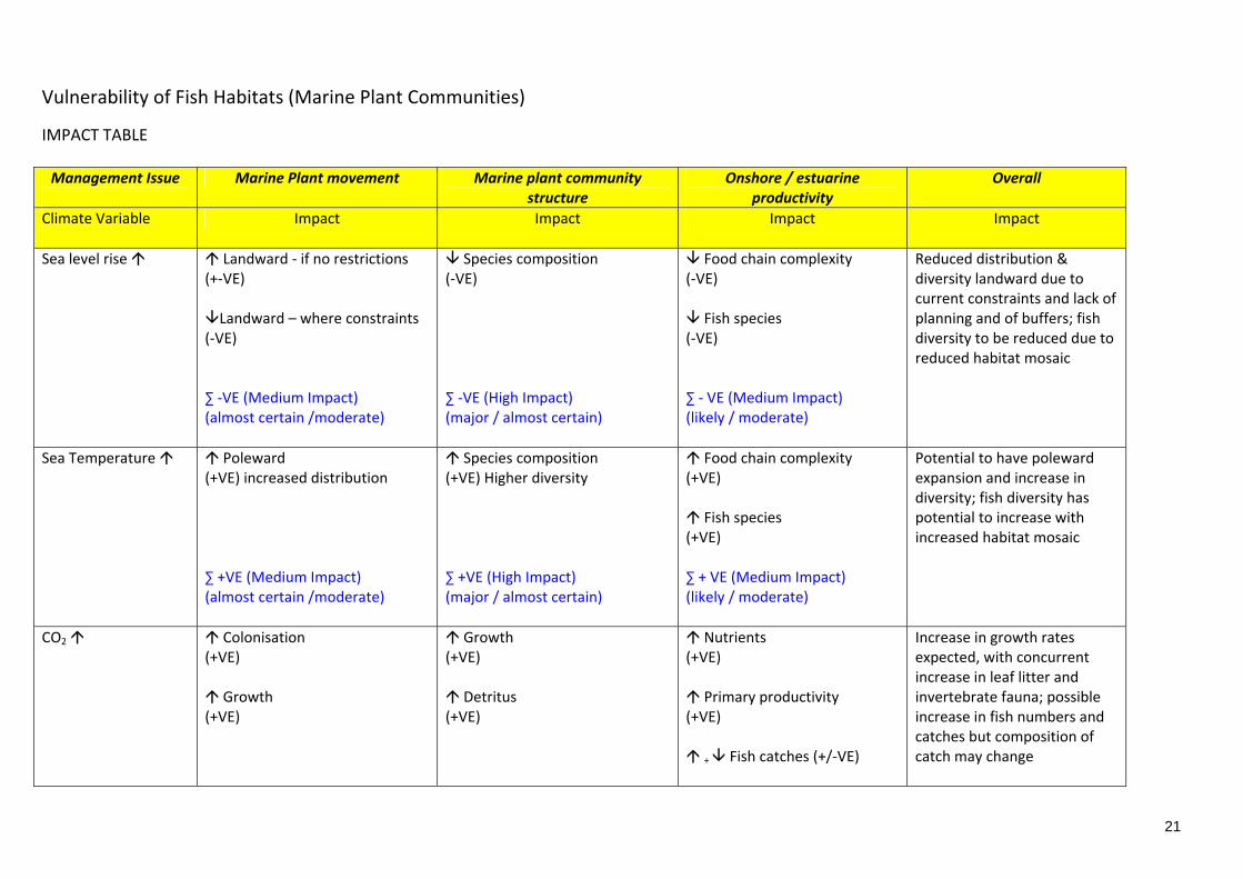
Vulnerability of Fish Habitats (Marine Plant Communities)
IMPACT TABLE
Management Issue
Marine Plant movement Marine plant community structure
Onshore / estuarine productivity
Overall
Climate Variable
Impact Impact Impact Impact
Sea level rise
Landward ‐ if no restrictions (+‐VE) Landward – where constraints
(‐VE) ∑ ‐VE (Medium Impact) (almost certain /moderate)
Species composition (‐VE) ∑ ‐VE (High Impact) (major / almost certain)
Food chain complexity (‐VE) Fish species
(‐VE) ∑ ‐ VE (Medium Impact) (likely / moderate)
Reduced distribution & diversity landward due to current constraints and lack of planning and of buffers; fish diversity to be reduced due to reduced habitat mosaic
Sea Temperature Poleward (+VE) increased distribution ∑ +VE (Medium Impact) (almost certain /moderate)
Species composition (+VE) Higher diversity ∑ +VE (High Impact) (major / almost certain)
Food chain complexity (+VE) Fish species
(+VE) ∑ + VE (Medium Impact) (likely / moderate)
Potential to have poleward expansion and increase in diversity; fish diversity has potential to increase with increased habitat mosaic
CO2
Colonisation (+VE) Growth
(+VE)
Growth (+VE) Detritus
(+VE)
Nutrients (+VE) Primary productivity
(+VE) + Fish catches (+/‐VE)
Increase in growth rates expected, with concurrent increase in leaf litter and invertebrate fauna; possible increase in fish numbers and catches but composition of catch may change
21

Management Issue
Marine Plant movement Marine plant community structure
Onshore / estuarine productivity
Overall
Climate Variable
Impact Impact Impact Impact
∑ +VE (Medium Impact) (likely /moderate)
∑ +VE (Medium Impact) (likely / moderate)
∑ +VE (Medium Impact) (possible / moderate)
Rainfall & Runoff
Colonisation (+VE) ‐ salinity ; water table Mortalities
(‐VE) ‐ inundation ; seed loss ; erosion ∑ ‐/+VE (neutral Impact)
Species composition ‐ landward Species composition ‐
poleward ∑ ‐VE (High Impact) (almost certain / major)
Nutrient flushing (+VE) Primary Production
(+VE) + Fish catches (+/‐VE)
∑ +VE (Medium Impact) (likely / moderate)
High rainfall frequency & lower salinity increases colonisation but countered by high erosion, extended inundation (‘drowning’) and seed loss; nutrient flushing inshore waters increased but timing will influence fish productivity
Overall estimate of risk
Marine plants restricted in certain areas of the coast due to constrictions from built environment or landform features. Reduction in extent of landward marine plant distribution. Potential expansion poleward.
Marine plant community structure will change with mangrove communities most likely benefiting at the expense of saltmarsh communities. Biodiversity to reduce landward but increase poleward.
Increase in primary productivity if marine plants are able to move with sea level rise and increased phytoplankton blooms due to temperature, rainfall & nutrient increases. Catch composition may change to favour detritivores (e.g. mullet) and planktivores (e.g. herring)
Deliberately blank
22

Vulnerability of Fish Habitats (Marine Plant Communities)
ADAPTATION TABLE
Management Issue
Marine Plant movement Marine plant community structure
Onshore / estuarine productivity
Overall
Climate Variable
Adaptation Adaptation Adaptation Adaptation
Sea level rise
Planning for movement Mapping & education
Better planning & mapping areas of current & potential extent – limited by existing landward development ‐VE (High vulnerability) (High impact / Medium adaptive capacity)
Mapping / Education Costs
Research
‐VE (High vulnerability) (High impact / Medium adaptive capacity)
Catch change ‐ different species Markets change
Costs
‐VE (Moderate vulnerability) (Medium impact / Medium adaptive capacity)
Marine plant communities are highly vulnerable to SLR; success of landward movements subject to rate of SLR; mapping & planning time‐consuming and in need of support; changes in fish communities will be reflected in catches and marketing viability
Sea temperature
Planning for movement Mapping & education
Better planning & mapping areas of current & potential extent – limited by existing poleward development ‐VE (Moderate vulnerability) (Medium impact / Medium adaptive capacity)
Mapping / Education Costs
Research
‐VE (High vulnerability) (High impact / Medium adaptive capacity)
Catch change ‐ different species Markets change
Costs
‐VE (Moderate vulnerability) (Medium impact / Medium adaptive capacity)
Marine plant communities are moderately vulnerable to SLR ; success of poleward movements subject to rate of temperature increase; mapping & planning time‐consuming and in need of support; changes in fish communities will be reflected in catches and marketing viability
23

CO2
Enhance natural colonization Growth
(+VE) +VE (No vulnerability)
Enhance diversity by plantings Costs
‐VE (Moderate vulnerability) (Medium impact / Low adaptive capacity)
Fish diversity and catches
+VE (No vulnerability)
Marine plant communities have zero or low vulnerability to CO2 changes; likely to enhance colonisation and growth and lead to increase fish productivity
Rainfall & Runoff
Planning Development in floodplain
+VE (No vulnerability)
Profile tidal slopes to enhance colonisation Costs
‐VE (High vulnerability) (High impact / Low adaptive capacity)
+VE (No vulnerability)
Marine plant communities have little vulnerability to Rainfall and Runoff where proper planning prevents development in floodplains; cost of shaping tidal profiles to enhance colonisation likely to be unacceptable
Overall estimate of vulnerability
High, where constraints are present landward and poleward; high costs of planning; extensive mapping (6,000 km of coastline) commitment
High (costs of intervention strategies)
Moderate (market adjustment & consumer acceptance); promotion of catch changes; training costs; gear cost changes
Deliberately blank
24

25
Vulnerability of Fish Habitats (Marine Plant Communities)
RISK STATEMENT
• The risk to the fishing sectors of losing marine plant habitats will result in changes in fisheries
production and in catch composition
• This level of risk requires an urgent response from senior levels of industry and from Local, State and Federal governments for policy and management
• The risk can be mitigated through provision of retreat areas for marine plant habitats through
strategic planning instruments at Local and State government levels and through fishing sectors adapting catch and marketing strategies for changes in catch composition
Vulnerability of Fish Habitats (Marine Plant Communities)
WAY FORWARD
o Select key sites that are audited in terms of current marine plant distributions and their diversity.
o Selected sites to reflect different coastal areas where low, medium and high levels of development
(i.e. potential barriers).
o Develop several scenarios of SLR and map and audit likely changes in marine plant distributions and diversity.
o Liaise with key stakeholders, e.g. local governments, to ensure that planning instruments consider
future marine plant communities and by definition, future fish communities and catching of these.

Meeting No. 19 Sydney, NSW
30 Nov, 2010
AGENDA PAPER State / Territory: Victoria Prepared by: Jeremy Hindell Position: Principal Research Scientist Organisation: Department of Sustainability and Environment Update – Estuary Management • Victorian Strategy for Healthy Rivers, Estuaries and Wetlands • Fish Kill in Anglesea river estuary – acid sulphate soil issues • Gippsland Lakes Conference • Release of Best Practice Guidelines for Assessing and Managing Acid Sulfate Soils. Available
on www.dse.vic.gov.au/coasts Update – Estuary Research • Centre for Aquatic Pollution Identification and Management (CAPIM) at the University of
Melbourne. It has an estuarine node investigating pollutant effects in estuaries, particularly from endocrine disrupting chemicals (EDCs) and heavy metals. Here is the website link: http://capim.com.au/
• Current ARC Linkage project (Melbourne Uni, DSE, GL&CT, Industry) – flows, salt wedge dynamics and fisheries
• New ARC Linkage project (Monash University, DSE, GL&CT, PV) – “Functional links between estuaries and their catchments: How does land use change affect estuarine ecological and bio-geochemical function?”
• Index of Estuarine Condition (IEC) • Estuarine Entrance Management Support System (EEMSS) • Estuarine Vulnerability to Climate Change – links with Species Distribution • Estuarine and Coastal Environment NARP – Victoria’s role • Fisheries Victoria – flows to support fisheries • Saltmarsh and mangrove review – not yet released
26
Meeting No. 19 Sydney, NSW
30 Nov, 2010
AGENDA PAPER State / Territory: ICAG Prepared by: Chris Rees Position: Manager, Coastal and Marine Branch Organisation: EPA Division, Department of Primary Industries, Parks, Water and
Environment, Tasmania Tasmanian member for ICAG (Intergovernmental Coastal Advisory Group) Update – National Coastal arrangements
• Under the NRM MinCo, Coastal Estuarine and Marine management has for the past 6 years been addressed through the National ICZM Framework (2004) and its Implementation Plan released in 2006. Six priority action areas in the IP include:
o Integration across the catchment-coast-ocean continuum o Land and marine based sources of pollution o Climate Change o Pest plants and animals o Planning for population change o Capacity building
• Specific mention of NEN is made in priority area 1, and issues of immediate interest to NEN are contained in all priority areas.
• ICAG has played a key role in coordinating implementation of the Framework for MACC. ICAG currently reports through MACC (Marine and Coastal Committee) to the NRM Ministerial Council. ICAG also currently acts as the MACC Coastal Environment Group.
• BUT, face to face meetings have not been held since early 2009and the work of the Group has been hampered by a rapid turnover of secretariat and Chair (Currently Steven Oxley)
• All Ministerial Councils are currently under review by COAG, with new arrangements expected to be announced in March 2011. The NRM MinCo is not expected to continue in its current form, and as yet no arrangements have been revealed for the portfolio of environmental management responsibilities. Coastal Estuarine and Marine issues are included in this review.
• Since 2008 the National ICZM Framework and IP have been under review, with lukewarm leadership from DEWHA (now Department of Sustainability, Environment, Water, Population and Communities). The ongoing series of ‘stocktakes’ of progress and reviews of priorities has seen solid early momentum on the IP largely lost, with Climate Change remaining the one major area of focus and activity.
• As a result the ICZM Framework has been largely by-passed with many ECM issues being addressed by bodies other than those recognised in the IP. This is acknowledged by ICAG.
• Meanwhile DCCEE has clearly taken a leadership role in progressing the coastal climate change and sea level rise adaptation agenda, moving the coordination of response away from DEWHA, and also away from the NRM MinCo and under COAG.
27
28
• It is expected now that COAGs Senior Officials Group on Climate Change Adaptation (SOGA) will coordinate work on the development of a national approach to address climate change impacts.
• SOGA will soon provide advice to COAG on a new CC adaptation framework.
• DCCEE’s focus can perhaps be gleaned from the recently released report ‘Developing a National Coastal Adaptation Agenda’, a summary of a national climate change adaptation forum held by DCCEE in Adelaide in early 2010.
In the Introduction, Minister Combet flags:
o Early planned adaptation
o Information, tools and clear policy guidelines
o Collaboration between governments
o Identification of impacts on coastal communities, industries, and environments
• Coastal Climate Change adaptation response has also been focused largely on the built environment and infrastructure and less so on impacts on natural systems.
• The November 2010 MACC meeting endorsed a fresh review of the ICZM Framework to take account of the outcomes of the COAG adaptation work program, but delaying until the new MinCo arrangements are known.
• CfoC continues to focus on national hotspots for coastal funding. Little Climate Change focus.
Current Impasse
• Agreement that a significant adaptation response is needed.
• Resources from DCCEE and through CfoC are required but remain scarce
• The recent Australian Govt. response to House of Reps Report ‘Managing our coastal zone in a changing climate: the time to act is now’ gives some indication of what might unfold over 2011, but we have to wait for detail.
• Waiting on MinCo makeup, and whether ICAG will be replaced with a body of different makeup.
• Waiting on SOGA’s Climate Change adaptation framework
• Waiting!!!!!!!!!!!!
Action
• ICAG is planning a meeting on early Feb 2011 which will develop recommendations on the ICZM framework and other matters for the MACC meeting later in the month.

Meeting No. 19 Sydney, NSW
30 Nov, 2010
AGENDA PAPER State / Territory: CSIRO Report from CSIRO: Nov 2010 General: The Wealth from Oceans Flagship is providing Australia's governments, industries and communities with the scientific knowledge, tools and approaches to make wise decisions about our uses of coastal environments through the ORCA Theme of :Our Resilient Coastal Australia ( See more under http://www.csiro.au/science/managing-coasts.html) Through the Our Resilient Coastal Australia research theme (involving experts from multiple divisions), the Flagship intends to provide the systems to measure and predict the state of our coastal environments ;science to enable marine planners to manage competing pressures that arise in major coastal developments ;leading edge science and technologies to invigorate Australia’s ocean-based industries. The WfO Flagship achieves national impact by working with government, industry and the community to champion integrated catchment-coast-ocean solutions that balance sustainable resource use with ecosystem protection, to ensure Australia’s coasts are productive yet resilient to continuing and future pressures The Flagship brings together a diverse range of CSIRO’s capabilities to comprehensively address the significant challenges and opportunities now facing Australia’s coastal zone by: providing better information on the structure, composition, dynamics and vulnerabilities of our coastal assets ;quantifying links between catchment influences and the impacts on coastal environments ;evaluating the cumulative effects of human impacts on coastal assets and distinguishing these from climate-related pressures and variability ;delivering more effective methods for monitoring and assessing coastal environments; developing methods for valuing coastal environmental assets and derived ecosystem services ;exploring opportunities for new ocean-based industries. Specific presentations at NEN In the area of earth observation developments the coastal water quality assessments by earth observation are maturing into management relevant information products such as water quality compliance monitoring and assessing trends and anomalies over periods of 10 years. In inland, estuarine and coastal lagoon waters the new satellite sensor WorldView-2 is presenting opportunities to map supratidal, intertidal and subtidal habitats (including bathymetry and water quality) at 2 m resolution. WorldView-2 (due to its 8 spectral bands (instead of traditionally 3 or 4 such as SPOT-5, IKONOS , QuickBird, Landsat etc.) is able to estimate chlorophyll and cyanobacterial pigment sin much more detail than ever before. The activity of quantifying links between catchment influences and the impacts on coastal environments is being addressed across the ealth from Oceans Flagship and the Water for A healthy Country Flagship through the project presented at the NEN meeting: Development of a National Framework for Catchment to Coast Modelling Project Goal. To develop a national framework for integrating catchment and receiving water models in Australia. Project Objectives (i)
29
30
To evaluate national and international examples on catchment-to-receiving water modelling in the context of catchment management, water quality and aquatic ecosystem health, (ii) To develop a “roadmap” for investment in integrated catchment-to-coast modelling for Water for a Healthy Country (Healthy Water Ecosystems) and Wealth from Oceans (Our Resilient Coastal Australia) for the next 5 years, including a detailed specification of models to be used and developed; (iii) To provide recommendations on the Australian and global science needs in linked catchment and receiving water models, and (iv) To publish the review and recommendations in a high-impact, international journal such as Water Resources Research. NEN members interested are invited to contact [email protected] for further involvement and interactions. ORCA researchers work closely with management, conservation and other research agencies to achieve conservation and management gains supported by science. Their work will significantly contribute to the national effort aimed at these priorities in the coastal and marine environment. Nationally, the Flagship directly supports:
• Australia's Oceans Policy • the National Cooperative Approach to Integrated Coastal Zone Management • the National Framework for Marine Research and Innovation.
The Flagship works closely with state governments to address regional development and deliver on regional strategies including the:
• Great Barrier Reef Rescue Program • South East Queensland Healthy Waterways strategy • Western Australian regional priorities in Ningaloo Marine Park, the Kimberley and south-
west Australia. • Ningaloo Collaboration Cluster - CSIRO and its partners are creating practical tools to help
manage our precious coastal resources in the face of growing coastal populations, development and tourism
• The INFORMD Project in Tasmania – a project where state-of-the-art integration is demonstrated between in situ data and monitoring systems ; gliders and autonomous UVs, 3-D hydrodynamical models and biogeochemical models and earth observation.
Internationally, the Flagship's research aligns with a number of conventions and treaties that aim to protect coastal and marine assets including the Convention Concerning the Protection of the World Cultural and Natural Heritage (the World Heritage Convention);Convention on Biological Diversity;Convention for the Prevention of Marine Pollution from Land-Based Sources; Ramsar Convention on Wetlands ;Convention on Migratory Species regional bilateral migratory bird agreements: JAMBA (Japan-Australia Migratory Bird Agreement, CAMBA (China-Australia) and ROKAMBA (Republic of Korea-Australia).

Meeting No. 19
Sydney, NSW
30 Nov, 2010
AGENDA PAPER National/ Geoscience Australia Prepared by: Lynda Radke (NEN Coordinator and GA Representative on NEN) Petroleum and Marine Division: Seabed Mapping and Coastal Management Project Climate change module: We have developed a climate change module for the Australian Government Department of Climate Change and Energy Efficiency (DCCEE). The module will provide information and tools to help communicate the risks of sea-level rise and other potential impacts of climate change on coastal areas. It will include elevation data and a modelling portal for access to existing and new elevation data and derived products, including sea level inundation maps for Perth to Mandurah, Adelaide, Melbourne, Sydney, Hunter and Central Coast & Brisbane and Gold Coast. The inundation footprints illustrate three sea level rise scenarios: a low (0.5m), medium (0.8m) and high (1.1m) scenario for a 2100 time period, with values based on IPCC projections (B1 and A1FI scenarios) and more recent science. The DCCEE have recently indicated that they will likely release the maps for all the regions except Adelaide in mid-December. NSW products: We are making good progress with the development of a web-based version of NSW DECCW’s Coastal Eutrophication Risk Assessment Tool (CERAT). It is anticipated that the tool (and the new report cards for NSW estuaries) will be released early in 2011 through the Natural Resource Management module. NSW DCCW’s Lagoon water and sediment data are now available on line. AODN. Discussions are underway to have OzCoasts data discoverable through the AODN. On-TRaCK: Development of a TRACK-sponsored of the Australian Riverscape Classification Service (AURICL) module is now underway. The AURICL classification service is based on an analysis of discrete river segments within the drainage network derived from the hydrologically corrected 9 second DEM . The river segments act as objects with relationships to any number of attribute data tables that describe the physical characteristics of some aspect of the riverscape (eg, geology, ecology). There are approx 370,000 segments in the dataset covering the TRaCK Northern Australia region. Reminder: GA maintains two field spectroradiometers that were purchased by the NLWRA. These instruments can be made available for loan subject to a few provisos. One of these provisos is that the data you collect is incorporated into the National Spectral Library. A preliminary page on the National Spectral Library has been set up (http://www.ozcoasts.org.au/nrm_rpt/library.jsp). The GA contact is Medhavy Thankappan (02-6249-9310; [email protected]). Reminder: The audit purchased 83 Coastal QUICKBIRD scenes (covering ~50,000 km2 of coastal Australia). Chris Auricht has set up a web page to view degraded versions of these images and to provide access to KML files for Google-Earth (http://www.auricht.com/Coasts/index.html and then follow links to the HTML Quickbird results; or use the direct link as follows: http://www.auricht.servebbs.com/maps/quickbird/index.html?basemap=Google+Hybrid&overlay=
31

32
QuickBird). Note: please let GA/Chris know if your security settings prevent you from viewing these images, or else ask your IT people to clear the site from its suspicious status. The complete images are also now available on a 43GB memory stick at a cost of $280 from the GA sales centre. For more information on acquiring the images (or adding your name to the list) follow this link: http://www.ga.gov.au/remote-sensing/get-satellite-imagery-data/ordering/pricing/quick-bird.jsp Geospatial & Earth Monitoring Division: Climate Change Project In collaboration with the Department of Climate Change and Energy Efficiency, Geoscience Australia has developed a national geomorphic classification scheme for the Australian coastal zone. This has been used to develop a nationally consistent coastal geomorphic dataset by collating and re-classifying more than 60 existing coastal data geomorphic datasets. The final product will compliment the Smartline (polyline map) of coastal geomorphology for use in coastal vulnerability assessments. The data is complete and currently being reviewed by the University of Tasmania and is due for release early in 2011. One of the key gaps identified in the above data is between Newcastle to Wollongong. This is currently being filled through a program of detailed mapping utilising a range of datasets and information, including aerial photography. The mapping program aims to fill the gap and develop a generic methodology for use elsewhere. The mapping and field validation will be complete early in the new year to be incorporated in the National Geomorphic Dataset. Following the first pass national coastal vulnerability assessment, Geoscience Australia is conducting some more detailed vulnerability assessments in south west Western Australia at Mandurah, Bunbury and Busselton. These involve impact assessments of future climate sea level and coastal response, specifically looking at the impact of inundation from storm surge. The studies aim to combine the results of the University of Sydney’s Shoreface Translation Model (providing estimates of the potential coastal response to SLR) with detailed hydrodynamic storm surge modelling (utilising both ANUGA and GCOM2) to determine the potential areas of inundation. Contact: Hamish Anderson | [email protected]|02 6249 9774| [email protected]; heading “coastal vulnerability" Geospatial and Earth Monitoring Division: A National Scale Vulnerability Assessment of Seawater Intrusion Project This project is being implemented by Geoscience Australia, the National Centre for Groundwater Research and Training (NCGRT) and State and Territory Water agencies on behalf of the Australian Government’s National Water Commission, and commenced in November 2009. The main objective of this project is to provide a national-scale vulnerability assessment of coastal aquifers currently affected by seawater intrusion and potentially at risk in the future as a consequence of over-extraction and/or sea-level rise due to climate change. Contact: Baskaran Sundaram 02-6249-9842 / [email protected] Geospatial and Earth Monitoring Division: National Earth Observation Group: Science and Strategy Project Spectroradiometer loan service: Jan – Feb 2010 – University of Tasmania campaign in Antarctica led by Dr Arko Lucieer

33
The ASD field spectrometer was used at Casey, Antarctica for collecting spectra of Antarctic coastal moss beds. The fieldwork period was from the 20th January 2010 until the 13th of Feburary 2010. The project aims to map the extent of the moss beds and quantify the changes that are occurring in the mosses, such as drought stress and die‐back. We also used an unmanned aerial vehicle (UAV) for mapping the moss beds. Spectral signatures were recorded for different species and a range of health conditions. The fieldwork was part of a larger Australian Antarctic Science Grant (Arko Lucieer to Steven Sagar – November 2010): March 2010 – Geoscience Australia Aquatic remote Sensing team campaign to Lord Howe Island to collect shallow water benthic substrate spectra. April 2010 – Borrowed by Kathy Murray at the WA Department of Environment and Conservation Contact: Stephen Sagar 02- 6249 9877/ [email protected]