11 soil management and earthworks - department of...
TRANSCRIPT

11.1 Soil and water management
11.2 Excavation and ground
disturbance
11.3 Extraction
11.4 Acid sulfate soils
11.5 Tools and resources
This chapter deals with controlling sediment
(soil and water runoff) as part of building and
construction works, minimising disturbance
from earthworks, extracting materials on
or near the coast, and the importance of
managing the impact of acid sulfate soils (ASS).
Coastal landforms and ecosystems have many functions and values that require protection from the impacts of earthworks and excavation associated with works in the coastal zone. Coastal dunes, for instance, protect houses and other developments from tidal surges and winds, while saltmarshes and seagrass meadows are critical fish nursery areas.
Clearing of vegetation and earthmoving activities can initiate soil erosion and, if not controlled, unwanted sediments could be discharged into wetlands or estuaries. In some areas these sediments might be contaminated toxic (e.g. heavy metals from mines or refineries) or acid sulfate soils, which, if disturbed, can cause water pollution or damage to structures. Even small-scale projects involve soil disturbance and can damage the coastal environment.
To protect the coastal environment, works activities should involve minimal impact on soils, landforms and receiving waters. This is achieved by planning for protection of coastal values, minimising soil disturbance and implementing effective erosion and sediment control measures.
The Soil and water management on building and construction sites, fact sheets (Derwent Estuary Program 2009) provide more technical detail on some of the issues presented in this chapter.
Soil management and ear thworks
Tasmanian Coastal Works Manual 1Soil management and earthworks
Tab photo: Machinery being used to remove pines from dunes. © Leah Page.
11

11.1 Soil and water management
This section provides information to help mitigate the impacts of building and construction site activities on soils, landforms and receiving waters in coastal areas through the use of erosion and sediment control measures.
Erosion is the removal of soil by the flow of wind and water. It occurs naturally, but can be intensified by building and construction activities. When erosion occurs soil particles become suspended in water or air and are transported downstream or downwind, eventually settling out as sediment, sometimes far away from the building or construction site.
Soil erosion on building and construction sites can be a major source of sediment pollution in waterways. Considerably more soil erosion is likely to occur during the construction phase than will occur in the rest of the building’s lifetime. In fact, a single building block can lose four truckloads of soil in one storm. Any sediment that moves off-site typically enters stormwater drains, clogging the stormwater system and transporting attached pollutants, including oils, heavy metals and hydrocarbons, into local waterways. Excessive sediment that enters waterways can kill fish and aquatic plants, silt up streams, and block stormwater pipes, which can lead to increased flooding.
11.1.1 Legislation and approvals
There is a range of legislation that provides for soil management during building and construction in the coastal zone. Appendices 1 and 2 provide details of legislation likely to be relevant. Local councils have the power and responsibility to regulate the building and construction industry.
It is essential to have the approval of the land
manager before undertaking any earthworks. On areas of public land the land manager may be the local council or DPIPWE (Crown Land Services or Parks and Wildlife Service). Because of the high level of disturbance it will also be essential to identify any potential Aboriginal or cultural heritage sites and any significant wildlife or vegetation values. Assessments and approvals may be required.
11.1.2 Appropriate soil and water management for coastal areas
Consider sediment and erosion control at the planning stage, well before any ground disturbance/construction occurs. The alternative – addressing sediment and erosion control as an additional feature after planning and design has been developed – can both limit opportunities for effective soil and water management and increase the cost of the system.
Planning should include identification of the values of the area, including potential threats such as coastal processes, toxic sediments and preparations for erosion and sediment control and rehabilitation.
Avoid works on unstable coastal landforms such as seabeds, mobile dunes (in particular foredunes), cliffs and beaches. If such works cannot be avoided, they must be carefully managed as they can greatly increase erosion, which may lead to loss of infrastructure, danger to the public and loss of wildlife habitat.
Foredunes are especially vulnerable to erosion if the vegetation is removed or the dune is damaged by machinery during construction works. The best way to avoid damage to foredunes during works on the shore is to protect the vegetation that stabilises the sand. Repair damage as soon as possible. Refer to Chapter 6 Coastal landscape management and Chapter 7 Vegetation management.
Tasmanian Coastal Works Manual2 Soil management and earthworks
11.1
Inappropriate excavation can increase the vulnerability of beaches and other soft coastlines to erosion and flooding caused by rising sea levels.
Choose a site and methods that minimise interference
with coastal processes, landforms and ecosystems. Obtain technical advice from a geomorphologist and/or engineer; and check the Geoconservation database, because some coastal landforms have
Tasmanian Coastal Works Manual 3Soil management and earthworks
11.1
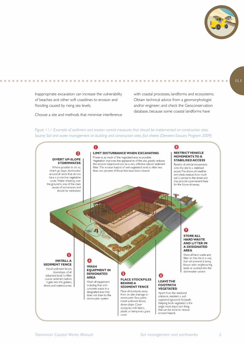
Figure 11.1 Example of sediment and erosion control measures that should be implemented on construction sites. Source: Soil and water management on building and construction sites, fact sheets (Derwent Estuary Program 2009)

important geoheritage values. Available on the internet on Tasmania’s Land Information System (LIST).
Avoid impacts on coastal habitats or ecosystems. Seek specialist advice and identify all natural values, such as threatened species, significant wildlife habitat and important vegetation communities. Obtain specialist advice if working near sensitive wildlife habitat, such as shearwater rookeries or penguin colonies. Also consider providing for wildlife requirements (e.g. when revegetating an area, remember that some shorebirds require bare patches to build their nest in the sand).
It is important to identify and protect cultural heritage values, conducting surveys where necessary. Assessments, surveys and permits may be required from Aboriginal Heritage Tasmania and Heritage Tasmania. Refer to Chapter 5 Cultural heritage management.
Some areas have toxic sediments (e.g. heavy metals from mines or refineries) and acid sulfate soils (ASS), which may cause water pollution or damage to structures if disturbed. Investigate the possibility of the presence of ASS prior to any development. Use the ASS information on the DPIPWE ASS web page or mapping from the LIST (see section 11.5 Tools and resources). Obtain specialist advice about safe methods for disposing of excavated materials that contain toxic materials (e.g. heavy metals) or ASS (See section 11.4).
Machinery, vehicles and vessels used during construction can introduce weeds, pests and diseases and should be cleaned off-site before travel to the work site.
11.1.3 Sediment collection structures
Sediment collection structures are designed to intercept and collect sediment in runoff before it reaches waterways. They should be designed to cope with major rainstorms of the type expected to occur in the area. Install the structures before the development begins.
Sediment collection structures require regular inspection and maintenance. After each significant rainfall event, check for damage or clogging by silt and debris.
Sediment collection structures may include, but are not necessarily limited to, the following:
• Sediment fences are usually constructed of heavy duty geotextile and must be installed parallel to the contours of the site. They can also be placed around stormwater pits.
• Fibre rolls are log-like products consisting of biodegradable fibres. They can be hessian socks filled with mulch or straw, or rolled coir (coconut fibre) placed across drainage lines or installed around stormwater pits to filter sediment from runoff.
• Stormwater pit traps are baskets or trays placed just below the entrance to the stormwater pit to prevent sediment entering the drain.
Refer to the Soil and water management on building and construction sites, fact sheets (Derwent Estuary Program 2009) for more information.
Tasmanian Coastal Works Manual4 Soil management and earthworks
11.1

11.1.4 Soil and Water Management Plans (SWMPs)
Subdivisions or activities that create more than 250m2 of ground disturbance will typically require a Soil and Water Management Plan (SWMP) to be submitted to council with the building or development proposals, prior to any site disturbance. Once approved by council in a building or planning permit, all building and construction works need to be conducted in accordance with the SWMP.
SWMPs are specific site plans or drawings that detail sediment and erosion control measures on building and construction sites. They show the type, location, design, installation and maintenance schedule for all these measures and should be considered as the blueprint for controlling all anticipated erosion and for preventing sediment from leaving a site.
A SWMP can easily be developed by overlaying information on a copy of the engineering site drawings. The plan must detail the site development and all the systems intended to minimise erosion and trap sediment.
If one is required, submit the SWMP to council. Ensure that council approval is given before you start work or you may be in breach of your permit.
Keep a copy of the council-approved SWMP at the site at all times and ensure that all on-ground workers understand the SWMP. Implement, update and maintain the control measures shown in the SWMP.
See Soil and water management on building and construction sites fact sheet 3. Soil and water management plans (Derwent Estuary Program 2009) for further information.
11.2 Excavation and ground disturbance
This section covers excavation and ground disturbance for small-scale activities, such as access management and trench digging and larger scale activities such as the construction of coastal infrastructure. Erosion control structures and soil and water management plans will be required for construction sites. Large-scale activities will require Environmental Management Plans, which will specify measures for minimising impacts on coastal values.
Avoid works on unstable coastal landforms such as seabeds, shoreline mobile dunes (in particular, foredunes), cliffs and beaches. If unavoidable, manage such works carefully. Foredunes are especially vulnerable to erosion if the vegetation is removed or the dune is damaged by machinery during construction works. The best way to avoid damage to foredunes during works on the shore is to protect the vegetation that stabilises the sand. Repair damage as soon as possible.
Particular precautions are required with the use of machinery, particularly large machines such as excavators and bulldozers, on fragile and unstable coastal soils.
Refer to Chapter 15 Shoreline modification for particular information on shoreline protection structures, reclamation and dredging.
Tasmanian Coastal Works Manual 5Soil management and earthworks
11.2

Excavation can be detrimental to coastal values by:
• damagingAboriginalheritage
• damaginghistoricculturalheritage
• damagingsitesofgeoconservationsignificance
• disturbinglandformssuchassaltmarshes,tidalflats,barwaysandrivermouths
• removingthesandsupplyfromdunes,beaches,estuary beds or seabeds
• increasingerosionandsedimentation(locallyornearby)
• destroyingterrestrialormarinevegetation
• destroyingwildlifehabitat(e.g.fishnurseries)ordisruptingbreeding(e.g.shorebirds)
• disturbingbottomsedimentsandreleasingcontaminants(e.g.heavymetals)
• disturbingacidsulfatesoils
• pollutingwater
• producinglargeamountsofspoil,whichmaybecontaminated
• spreadingmarineandterrestrialweeds,pestsand diseases.
Tasmanian Coastal Works Manual6 Soil management and earthworks
11.2
Figure 11.2 Construction of coastal road in southern Tasmania. © Chris Rees

11.2.1 Appropriate ground disturbance methods
Planning earthworks, including identifying values of the area as well as potential threats, is important when selecting appropriate construction equipment and methods that will minimise coastal disturbance.
Before commencing work, ensure all assessments have been done and approvals received, including approval from the land manager. Ensure that all staff and contractors have been briefed on the coastal values that need to be considered within the work area and any restrictions or conditions required to protect them. Provide appropriate supervision to ensure these conditions are met.
Keep ground disturbance to a minimum. Time construction works to minimise the duration of soil exposure (e.g. avoid works when prolonged heavy rain or strong winds are expected) and to allow planting of bare areas during late autumn and winter.
Protect surface water and groundwater quality. Take steps to minimise pollution and changes to the natural drainage patterns of the shore area. Install erosion control structures and implement erosion control strategies. These will significantly reduce the need for and the size and cost of installing sediment collection structures.
Each site is different; sediment and erosion control measures need to be designed on a site-by-site basis.
Minimise ground disturbance as far as is practicable. All earthworks should be kept to a minimum and should be closely linked with the commencement of major works. Thorough and careful planning is the best way to minimise environmental impacts. At the planning stage, consider the following:
• Avoid the need for earthworks, by working with the natural contours of the site. Limit building or
construction on steep inclines. On slopes, choose a subfloor method that will minimise excavation.
• Limit the area of soil disturbance (the excavation envelope) to the minimum required, e.g. the building footprint only.
• Identify suitable sediment and erosion control measures for the excavation envelope.
• Schedule earthworks in phases throughout the project, to reduce erosion potential; rehabilitate exposed areas quickly, to reduce the amount of soil exposed at one time.
• Retain as much stripped topsoil as possible for re-use during landscaping and site rehabilitation.
Before starting site works, the following actions will help to minimise the risk of ground disturbance:
• Identify vegetation, including grass buffers, around the construction site to preserve throughout the development. Mark this as a ‘no go’ area on all work plans, including the Soil and Water Management Plan (if required).
• Install sediment and erosion control measures.
• Ensure the operators of earthmoving equipment are aware of the excavation envelope and where stockpiles will be located.
Once site works have commenced:
• Ensure vegetation buffers are protected.
• Carry out staged excavation and stabilisation (if applicable).
• Maintain sediment and erosion control measures.
• Stabilise soil stockpiles by placing sediment fences around their lower edges, cover with fabric, plastic or vegetation.
See Soil and water management on building and construction sites fact sheet 5. Minimise soil disturbance (Derwent Estuary Program 2009) for further information.
Tasmanian Coastal Works Manual 7Soil management and earthworks
11.2

11.2.2 Precautionswhenusingheavymachineryincoastalareas
On fragile and unstable coastal soils, special precautions are required with the use of machinery, particularly large machines such as excavators and bulldozers.
Ensure the type and size of heavy equipment is appropriate for the site and the works. Use smaller machines wherever possible, to reduce damage to coastal systems. Keep off foredunes and other unstable areas wherever possible.
Use soil roughening techniques to minimise impacts when using heavy machinery (i.e. non-wheeled vehicles) on exposed slopes. Don’t smoothly grade slopes with compacted soils. This will increase runoff, is hard to revegetate and is highly susceptible to soil erosion.
Don’t track heavy machinery across the slope. The track marks will create furrows that water will flow down when it rains.
Use erosion control measures before starting earthworks and protect excavations during construction to prevent collapse of unstable or loose earth or sand.
Ensure operators and other workers follow all occupational health and safety procedures, for their own safety and to protect the environment (refer to the Workplace Standards Tasmania website).
Where oil or other fuels are stored, develop a plan to manage accidental spills.
Stabilise and rehabilitate the site as soon as practicable. Temporary stabilisation methods may be necessary if planting cannot take place within a reasonable time.
Follow the guidelines in the Soil and water management on building and construction sites fact sheet 5. Minimise soil disturbance (Derwent Estuary Program 2009).
11.2.3 Trenchdigging
Trench digging for the installation of pipes and services is often part of construction projects.
Planning is critical, to minimise environmental damage and erosion, and many of the principles described for excavation in coastal areas apply to trenches. In particular, erosion control measures need to be planned for and implemented before works start.
Ensure that trenches will not be exposed to water flows, as this can create serious erosion problems. Schedule works when rain is unlikely and keep trenches open for no more than three days. Minimising the size of the trench through careful planning is the simplest way to reduce erosion and also saves work.
Deposit excavated material up-slope of the trench and install diversion measures to control soil and water flow. Diversion measures such as banks or berms need to be aligned and spaced according to the slope of the land and the potential for erosion due to soil type and rainfall. The diversion measures need to discharge any runoff into a stabilised area or a sedimentation trap and ensure that runoff will not be channelled or funnelled together, which will increase erosion.
Retain the topsoil for rehabilitation. Backfill and rehabilitate trenches as soon as possible. Ensure subsoil is flled in first, then compact soil to 95% standard compaction, add topsoil, level it, and top up as necessary should subsidence occur.
Take care while backfilling to prevent the trench operating as a subsoil drain. The backfill should
Tasmanian Coastal Works Manual8 Soil management and earthworks
11.2

therefore be properly compacted and trench stops installed where gradients are considered steep enough to warrant them.
Dispersive soils and tunnel erosion
Excavation may increase the risk of soil dispersion and can result in tunnel erosion. Tunnel erosion results from the dispersion of clay soils in water (also known as dispersive or sodic soils). These clay soils collapse or disperse to form dissolved slurry when in contact with fresh water. Tunnel erosion usually occurs in the subsoil first, and drains can quickly enlarge and then collapse to form gullies.
Minimise the risk:
• Consider having the subsoil tested by a soil specialist for dispersive or sodic soils.
• Prevent ponding of water wherever possible.
• Always bury exposed subsoils with topsoil and revegetate.
Refer to Soil and water management on building and construction sites fact sheet 9. Protect service trenches and stockpiles (Derwent Estuary Program 2009).
Tasmanian Coastal Works Manual 9Soil management and earthworks
11.2
Figure 11.3 Best practice techniques to minimise erosion when digging trenches. Source: Managing urban stormwater: Soils and construction, vol 2A (Department of Environment and Climate Change 2008a)

11.3 Extraction
This section deals with the extraction of sand and gravel for use as construction materials for buildings and roads. Coastal beaches, dunes and rivers are sometimes used as sources of these materials, but extraction can severely degrade or destroy these ecologically sensitive and dynamic landforms.
Extraction of material from the shoreline, seabed, estuary or riverbed (e.g. sand, shingle, shell) can only be sustained if the natural processes can replace that material. Determining the capacity of natural processes to replenish material requires specialist study and could be expensive.
Extracting sand or gravel from a waterway is only acceptable in rare situations where it benefits the waterway – for instance, where human activities have caused a build-up of sediment that has eroded or changed the course of a stream, or destroyed habitat. For example, at some sites sediments released from old mining operations have formed a sediment slug (a large body of sediment that gradually moves downstream).
Any extraction works should minimise the amount of sediment entering adjoining waterways or coastal waters, and use appropriate sediment traps. Rehabilitation works should be undertaken during and after mining, extraction or exploration activities. These works must be appropriate for the intended future use of the site and, as far as practicable, should be completed before the expiry of the mining lease or exploration permit.
11.3.1 Legislation and approvals for extracting materials
There is a range of legislation that could be triggered by plans for extracting minerals and resources. Refer to Chapter 1 and Appendices 1 and 2 for details of general legislative requirements. In addition to these, the Mineral Resources Development Act 1995 provides for the development of mineral resources consistent with sound economic, environmental and land use management, and applies to all land and minerals in Tasmania.
Mineral exploration is regulated by the Mineral Resources Development Act 1995. Mineral Resources Tasmania (MRT) is responsible for administering the Act. Most mineral exploration work is undertaken with a licence and in accordance with the Mineral exploration code of practice (Bacon 1999).
Mining exploration for economic mineral deposits requires the completion of an Exploration Licence Application Form, from the Registrar of Mines, Mineral Resources Tasmania. MRT officers must be consulted before on-ground exploration activities start. A rehabilitation plan may be required.
Quarrying or mining requires an application for a mining lease. Details of proposed mine and quarry developments (including planned rehabilitation practices) must be provided on an ‘Environmental Impact Information – Mining Form’, from Mineral Resources Tasmania.
Where the annual disturbance is less than 5000m3 for sand or stone and 1000 tonnes for metallic mines, the operation is classified as a Level 1 operation and a council planning permit and environmental approval are required. Above that level, a Development Proposal and Environmental Management Plan is also required by DPIPWE. A comprehensive plan is required by Mineral Resources Tasmania for any
Tasmanian Coastal Works Manual10 Soil management and earthworks
11.3

necessary decontamination or rehabilitation of the site.
Where a quarry is operated by Forestry Tasmania in state forest, exclusively for constructing and maintaining roads, a certified forest practices plan (quarry) is required rather than a mining lease and a planning permit.
Extracting gravel or rock for lawful roadworks within a road reserve does not require a separate extractive industry approval from council or DPIPWE, or a mining lease from MRT.
Removing natural materials from Crown land requires a licence under the Crown Lands Act 1976. Most shorelines are Crown land, some private landholders have title to the high water mark or beyond. Areas below high water mark generally belong to the Crown.
11.4 Acid sulfate soils
This section covers the importance of managing acid sulfate soils in the coastal environment and the implications for coastal works and development. Acid sulfate soils (ASS) are soils that contain iron sulfides. When the iron sulfides are exposed to the air and become oxidised, sulfuric acid is released. Soils in which the sulfides have not been oxidised are often called potential acid sulfate soils (PASS).
Sediments (layers of soil) that are rich in iron sulfides occur naturally, and may underlie other soils. As sea water is a rich source of sulfates, ASS is most likely to be found in areas where marine sediments have accumulated (both recently and in the past when sea levels were higher).
ASS can be exposed to air through lowering of groundwater levels during a drought or through
disturbance by excavation associated with development and land management activities such as water extraction. When ASS are exposed to oxygen, oxidation of the sulfides can occur, generating large amounts of sulfuric acid in the process. Re-wetting of these materials can flush this acid into drains and waterways.
Release of sulfuric acid from the soil can in turn release iron, aluminium and other heavy metals (particularly arsenic) from the soil. Once mobilised in this way, the acid and metals can have a variety of adverse impacts: killing vegetation, seeping into and acidifying groundwater and water bodies, killing fish and other aquatic organisms, and degrading concrete and steel structures to the point of failure.
11.4.1 Legislation and approvals
A range of legislation applies to protecting coastal environments from the impacts of acid sulfate soils. Refer to Appendices 1 and 2 for a summary of the relevant legislation.
Permission to undertake works on any land with ASS or PASS must be given by the relevant landowner or land manager. On areas of public land, the land manager may be the local council or DPIPWE (Crown Land Services or Parks and Wildlife Service).
In areas under the control of the local planning scheme, councils have a responsibility to ensure any application involving ASS is assessed properly, and will advise on the appropriate approvals and whether an ASS management plan is required.
Approvals will also be required if the works are on land managed by other agencies. In some instances, the application may be referred to the Environment Protection Authority (EPA) for assessment.
Tasmanian Coastal Works Manual 11Soil management and earthworks
11.4

11.4.2 Impacts of acid sulfate soils
Acid sulfate soils are found in coastal areas of Tasmania. These soils are generally harmless in a dormant state but, once disturbed, the soil reacts with oxygen in the air to form sulfuric acid.
Acid generated by ASS can corrode infrastructure, in particular concrete and roads. Accelerated corrosion of metals, etching of concrete and exposure of aggregate are typical early signs of attack by acidic water. The acid and heavy metals that may also be released from the soil are harmful to marine ecosystems and pose a threat to humans, livestock, wildlife and vegetation.
As long as the soils remain under the water table, oxidation cannot occur. However, once oxidised, re-wetting the soils following disturbance through excavation or water extraction can produce highly acidic leachate. To improve water quality and minimise impacts, disturbed areas may need expensive rehabilitation and/or treatment. Specialist advice will be required in these situations.
Indicators of ASS impacts include cloudy blue-green water or excessively clear water, iron stains, poor pasture, scalded soil, a yellow soil layer or a dark-grey soil layer.
ASS can be prone to subsidence and foundations or earthworks built on these soils may slowly settle or subside unevenly. Structures may require either extensive piles or the laying of an extensive load-spreading membrane. This increases construction costs.
Any development that disturbs the natural sediments, whether terrestrial, estuarine or subaqueous, has the potential to expose and oxidise ASS.
Risk activities include:
• coastal developments, such as housing, resorts, marinas and canal estates
• coastal reclamation
• infrastructure development such as roads, bridges, pipelines and residential services
• agricultural activities such as field drainage, water extraction and deep cultivation
• marine or estuarine activities such as dredging.
Black ooze
Insomelow-energywaterenvironments,monosulfidicblackooze(MBO)canaccumulate.Thesegel-likesubstancesoftenoccurinfreshwaterdrainsandwatercourses,oronthefloorofshelteredbays,coastallagoonsandestuaries.Changestowaterfloworincreasedboattrafficupstreamcanresultindisturbanceofthesesediments.Oncedisturbed,MBOscanleadtorapiddeoxygenationofthewater,whichwillkillfish.
MBOsarepredictedtooccurinpartsofPittwater,MoultingLagoon,GeorgesBayandMacquarieHarbour;disturbancecouldhavesignificantadverseimpactsontheaquacultureindustry,residentialdevelopments and biodiversity.
Figure 11.4 Monosulfidic black ooze. © Rob Moreton
Tasmanian Coastal Works Manual12 Soil management and earthworks
11.4

11.4.3 Acid sulfate soils in Tasmania
In Tasmania, there are extensive areas of ASS in low-lying areas along the northern and eastern coastlines, extending inland along estuaries and marshlands, and in inland back swamps and floodplains at elevations of less than 20m above mean sea level.
ASS is also found on Flinders and King Islands, and other areas. Maps prepared by DPIPWE, available on the LIST website, indicate possible areas that are likely to contain ASS.
In Tasmania , ASS is most likely to be found in areas of recent and older marine sediments associated with accumulations of organic matter and which have generally remained in a saturated state.
A survey for acid sulfate soils by Mineral Resources Tasmania (Gurung 2001) indicated that about 200km of Tasmania’s coastline could have sediments that contain iron sulfides. The survey found evidence of acid drainage from disturbance of ASS in a number of locations, including intensively farmed areas in
the north-west. More recent work by DPIPWE in 2008–2009 predicted that some 91 000ha of land may have a high risk of encountering potential ASS and a further 616 000ha has a low risk.
To date, the impact of ASS in Tasmania has been limited. This probably reflects the relatively low development pressure that these areas have encountered. This pressure is set to increase in coming years with a growth in coastal development, creation or enlargement of marinas, land reclamation and dredging. However, at least one fish kill in Tasmania has been linked to ASS.
On mainland Australia, massive kills of fish, crustacean and oysters have been attributed to ASS and extensive disturbance and exposure of sulfidic sediments has resulted in millions of dollars’ worth of damage to fisheries and aquaculture, infrastructure, and coastal land – a situation that can be avoided in Tasmania.
11.4.4 Reducing impacts of acid sulfate soils
Small-scale activities will not disturb very large areas of ASS but disturbance of the soils on a small scale, whilst not requiring a management plan, may have an impact on any infrastructure installed and could cause small-scale localised contamination.
Larger-scale projects in ASS areas can easily lead to environmental damage, which may be difficult and expensive to remediate. Thorough investigation is essential before starting works, to identify whether there is a probability of encountering ASS and, on that basis, determine whether the works are appropriate.
If acid sulfate soils can be avoided, by relocating or redesigning the proposed project, then this should always be the first option. Prevention of
Tasmanian Coastal Works Manual 13Soil management and earthworks
11.4
Figure 11.5 Blue-green cloudy water is evidence of acid sulfate soil. © Rob Moreton

acid discharge is better than trying to rehabilitate degraded land and water.
Careful observation of the soil material and any leachate should be maintained in case unexpected ASS materials are encountered.
Workers should be aware of the signs and indicators of ASS and work should cease immediately if such signs are observed, if ASS are encountered or if there is any suspicion that ASS are present and there is no management plan. Then specialist advice should be sought for the production of a management plan.
It is probably not always necessary to relocate small-scale works away from acid sulfate soil areas, but it is important to reduce the amount of disturbance of these sediments and undertake measures to minimise impacts.
• Cover in situ soils with clean fill, to provide adequate depth for foundations or excavations so that ASS layers are not intercepted.
• Minimise disturbance, dig small shallow holes where possible.
• Redesign the earthworks layout.
• Redesign existing drains.
• Minimise groundwater fluctuations.
• Neutralise by incorporating neutralising agents, e.g. lime, into the soil.
• Strategically re-bury PASS in deep voids below the groundwater table, and cover with either water or compacted soil to exclude oxygen.
Indicators of acid sulfate soils
• cloudyblue-greenwater,milkywhitewater,crystalclearwater,oryellowishbrownwater
• ironstainingandreddish-browndepositsincreeksordrains
• poorpastureorswampvegetation
• scaldedsoil
• orangeoryellowsoillayersormottles
• stickygreytobluish-greysoilswithorangestreaks
• gooeyblacksedimentsonbottomofdrains
• rotten-eggsmellfromfreshlyexposedsoils
• fishdeathsanddiseases
• etchingofconcreteandexposureofaggregate–typicalearlysignsofattackbyacidicwater
Tasmanian Coastal Works Manual14 Soil management and earthworks
11.4

11.4.5 Acid sulfate soils management plan
A management plan may be required for large-scale works that may disturb ASS or groundwater. A plan will detail the procedures to minimise and/or neutralise any impacts from the disturbance of ASS. Guidelines for the content of a management plan are presented in the Tasmanian acid sulfate soil management guidelines (DPIPWE 2009a).
Planning should include specialist advice and measures to minimise potential impacts, including problems in areas that might be drained and disposal of dredged material.
Other matters to consider:
Assess the need for supporting structures on subsidence-prone soils.
Identify rehabilitation methods, including the appropriate disposal of any ASS material.
Obtain specialist advice about safe methods for disposing of excavated materials that contain toxic materials or acid sulfate soils.
11.4.6 ClimatechangeandASS
Potential climate change impacts on areas with ASS or PASS include sea level rise and more frequent and severe storm events, leading to inundation and erosion. Increased erosion of coastal dune systems, tidal mud flats and estuary riverbanks could lead to more acid sulfate soils being exposed.
Changes to rainfall and associated river flows may actually lead to lowering marshes and wetlands and decrease the flow of waterways in some areas, which could also result in exposing acid sulfate soils.
With increased stress on coastal systems due to climate change, it is important to minimise disturbance of acid sulfate soils to avoid adding pressure to already stressed ecosystems.
Tasmanian Coastal Works Manual 15Soil management and earthworks
11.4
Figure 11.6 Acid damage to bridge. © Rob Moreton

11.5 Tools and resources
Complete details of all printed publications listed here are provided in a reference list at the end of the Manual. Other tools and resources including websites are collated in Appendix 5.
Aboriginal Heritage Tasmania
Desktop search for Aboriginal heritage sites
www.aboriginalheritage.tas.gov.au
Coastal Values data
Vegetation, species habitat and geomorphic values data for a 100m-wide coastal strip of the northern, southern and north-western Tasmanian NRM Regions. Available on the LIST
www.thelist.tas.gov.au
Indicative mapping of Tasmanian coastal vulnerability toclimatechangeandsealevelrise (Sharples 2006)
Natural Values Atlas
Provides authoritative, comprehensive information on Tasmania’s natural values. Download a free registration form from the website to access
https://www.naturalvaluesatlas.tas.gov.au
PlanningguidelinesfortheTamarEstuaryandforeshore (Watchorn 2000)
Smartline or coastal vulnerability maps
Maps of coastal landform types and their vulnerability to sea level rise can be found under ‘Climate Change’ layers on the LIST and the OzCoasts website. The data is presented as a ‘smart line’ following the coastline, with information on the geology of the coast readily interpreted for particular coastal areas.
www.thelist.tas.gov.au
www.ozcoasts.org.au
Soil and water management on building and constructionsites,factsheets (Derwent Estuary Program 2009)
The fact sheets can be obtained as hard copies in a folder from the Derwent Estuary Program, or local councils in southern Tasmania and are available on both the Derwent Estuary Program and NRM South websites.
www.derwentestuary.org.au
http://www.nrmsouth.org.au/information/view_Publications_15130754/view_Technical_Sheets_Manuals__Reports_15130759/
The factsheets are divided into sediment control measures and erosion control measures. Erosion control measures hold the soil in place and reduce soil removal by rainfall or runoff. Sediment control measures capture the eroded soil from the runoff preventing it from leaving the building or construction site.
Tasmanian Coastal Works Manual16 Soil management and earthworks
11.5

There are 19 fact sheets, each covering different sediment and erosion control measures. Use the fact sheets as needed. Remember: each site is different and sediment and erosion control measures need to be assessed on a site-by-site basis.
1. Soil & Water Management on Large Building & Construction Sites
2. Soil & Water Management on Standard Building & Construction Sites
3. Soil & Water Management Plans
4. Dispersive Soils – High Risk of Tunnel Erosion
5. Minimise Soil Disturbance
6. Preserve Vegetation
7. Divert Up-slope Water
8. Erosion Control Mats & Blankets
9. Protect Service Trenches & Stockpiles
10. Early Roof Drainage Connection
11. Scour Protection – Stormwater Pipe Outfalls & Check Dams
12. Stabilised Site Access
13. Wheel Wash
14. Sediment Fences & Fibre Rolls
15. Protection of Stormwater Pits
16. Manage Concrete, Brick & Tile Cutting
17. Sediment Basins
18. Dust Control
19. Site Revegetation
Transport Tasmania
Roadwork specification R92 – Underground Service Facilities.
www.transport.tas.gov.au
Tasmanian reserve management code of practice (PWS et al. 2003)
Soil conservation and land rehabilitation guidelines
WorkplaceStandardsTasmania
For OH&S procedures
www.wst.tas.gov.au
Extraction
Mineral Resources Tasmania
Exploration Licence Application Form, Environmental Impact Information - Mining Form
Mineral exploration code of practice (4th ed) (Bacon 1999)
Quarry Code of Practice (Department of Primary Industries, Water and Environment, and Department of Infrastructure, Energy and Resources 1999)
www.mrt.tas.gov.au
Tasmanian Coastal Works Manual 17Soil management and earthworks
11.5

Acid sulfate soils
Acidsulfatesoilinformationkit
Collation of resources from around Australia, includes the National Strategy and a booklet on keys to success. Available from the National Acid Sulfate Soil website
http://www.environment.gov.au/archive/coasts/cass/index.html
DPIPWELandConservationBranch
Instructions on how to use the maps on the LIST for ASS
Tasmanian acid sulfate soil management guidelines (DPIPWE 2009a)
Includes guidelines for the development of ASS management plan
Links to pamphlets, poster and more information on ASS are also available here www.dpipwe.tas.gov.au/acidsulfatesoils
Guidelinesforsamplingandanalysisoflowlandacidsulfate soils (ASS) in Queensland (Ahern et al.1998)
http://www.derm.qld.gov.au/land/ass/pdfs/sample_analysis_guide.pdf
Nationalstrategyforthemanagementofcoastalacid sulfate soils (NSW Agriculture 2000)
Prepared by National Working Party on Acid Sulfate Soils
http://www.mincos.gov.au/__data/assets/pdf_file/0003/316065/natass.pdf
TheLIST
Predictive maps of possible acid sulfate soil occurrence
www.thelist.tas.gov.au/
Log onto www.dpipwe.tas.gov.au/acidsulfatesoils and follow the instructions on how to use the LIST database to access ASS predictive mapping.
Tasmanian Coastal Works Manual18 Soil management and earthworks
11.5