0 legend - epa waepa.wa.gov.au/sites/default/files/referral_documentation/part 3.pdf · 2 0 0 0 8 0...
TRANSCRIPT

!(
!(
!(
!(
!(
!(
!(
!(
!(
!(
492000 496000 500000 504000 508000 512000 51600080
4400
080
4800
080
5200
080
5600
080
6000
080
6400
080
6800
080
7200
080
7600
0
Coordinate SystemName: GDA 1994 MGA Zone 50Projection: Transverse MercatorDatum: GDA 1994
Figure: 6.4Project ID: 1645
Drawn: BHDate: 04.11.15Introduced Species
Recorded in theProposal Area A4
K0 2 4
Kilometres
LegendThunderbird Proposal Area
Proposed Disturbance Areas
Introduced Species
!( Cynodon dactylon
!( Malvastrum americanum
!( Stylosanthes hamata
!( Stylosanthes scabra
!( Tridax procumbens
1:150,000Absolute Scale -

490000 500000 51000080
5000
080
6000
080
7000
080
8000
0
Coordinate SystemName: GDA 1994 MGA Zone 50Projection: Transverse MercatorDatum: GDA 1994
Figure: 6.5Project ID: 1645
Drawn: BHDate: 18.11.15Vegetation Communities
Recorded in theProposal Area
A4
K0 2 4
Kilometres
LegendThunderbird Proposal Area
Proposed Disturbance Areas
Vegetation UnitAtCp
BdEcAtApSt
BdEcAtSt
CdTcTc
CgApSt
CgDhHc
CgDhSt
EcAtSt
EtApStCpEo
GpAmStTc
MaMvEtCpCc
1:141,481Absolute Scale -

Sheffield Resources Limited Thunderbird Mineral Sands Project – EPA Referral Supporting Document
November 2015
43
Table 11: Representation of vegetation communities inside Proposal Area and proposed disturbance areas
Vegetation code Total area mapped
(ha)
Area within Proposal Area
(ha / % of mapped)
Area within Proposed Disturbance Areas (ha / % of mapped)
AtCp 625.1 608.0 (97%) 14.0 (2%) BdEcAtApSt 541.2 255.5 (47%) 203 (37%) BdEcAtSt 2,111.2 724.2 (34%) 229 (11%) CdTcTc 1,307.7 333.5 (25%) 3.5 (<1%) CgApSt 1155.4 657.6 (57%) 286.3 (25%) CgDhHc 110.7 107.3 (97%) 3.2 (3%) CgDhSt 2,041.4 912.5 (45%) 216(11%) EcAtSt 4,064.4 1452.4 (36%) 319 (8%) EtApStCpEo 1,759.5 460.2 (26%) 191(11%) GpAmStTc 1,633.5 677.8 (41%) 255.2 (16%) MaMvEtCpCc 352.6 35.8 (10%) 0.5 (<1%) Total 15,702.6 6,224.7 (40%) 1,723 (11%)

Sheffield Resources Limited Thunderbird Mineral Sands Project – EPA Referral Supporting Document
November 2015
44
Table 12: Vegetation units of the Thunderbird area
Vegetation unit mapping code Quadrats Vegetation description Associated species Area Mapped (ha)
AtCp
1 3 4 5 7
16 17 18
Landform: Sandy plain Acacia tumida var. tumida tall shrubland, over Sorghum timorense, Chrysopogon pallidus and Heteropogon contortus tussock grassland. Average species richness = 22.1 ± 5.6 Sample size = 8
Brachychiton diversifolius subsp. diversifolius Corymbia greeniana Dolichandrone heterophylla Eriachne obtusa Erythrophleum chlorostachys Galactia tenuiflora Grevillea refracta subsp. refracta Microstachys chamaelea Terminalia canescens
625.1

Sheffield Resources Limited Thunderbird Mineral Sands Project – EPA Referral Supporting Document
November 2015
45
Vegetation unit mapping code Quadrats Vegetation description Associated species Area Mapped (ha)
BdEcAtApSt
P1-Q03 P1-Q12 P1-Q13
P2-Q18C P2-Q48
Landform: Sandy plain Brachychiton diversifolius subsp. diversifolius and Erythrophleum chlorostachys low, open woodland, over Acacia tumida var. tumida and Acacia platycarpa tall, sparse shrubland, over Sorghum timorense sparse, tussock grassland Average species richness = 32.2 ± 3.8 Sample size = 5
Acacia platycarpa Acacia tumida var. tumida Brachychiton diversifolius subsp. diversifolius Chrysopogon pallidus Corchorus sidoides subsp. vermicularis Corymbia greeniana Dodonaea hispidula var. arida Erythrophleum chlorostachys Microstachys chamaelea Sorghum timorense
541.2
Sheffield Resources Limited Thunderbird Mineral Sands Project – EPA Referral Supporting Document
November 2015
46
Vegetation unit mapping code Quadrats Vegetation description Associated species Area Mapped (ha)
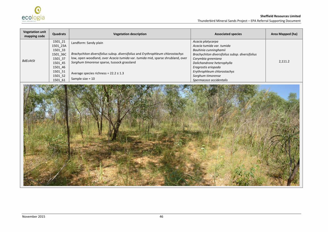
BdEcAtSt
1501_21 1501_23A 1501_33
1501_36C 1501_37 1501_45 1501_46 1501_51 1501_52 1501_61
Landform: Sandy plain Brachychiton diversifolius subsp. diversifolius and Erythrophleum chlorostachys low, open woodland, over Acacia tumida var. tumida mid, sparse shrubland, over Sorghum timorense sparse, tussock grassland Average species richness = 22.2 ± 1.3 Sample size = 10
Acacia platycarpa Acacia tumida var. tumida Bauhinia cunninghamii Brachychiton diversifolius subsp. diversifolius Corymbia greeniana Dolichandrone heterophylla Eragrostis eriopoda Erythrophleum chlorostachys Sorghum timorense Spermacoce occidentalis
2,111.2

Sheffield Resources Limited Thunderbird Mineral Sands Project – EPA Referral Supporting Document
November 2015
47
Vegetation unit mapping code Quadrats Vegetation description Associated species Area Mapped (ha)
CdTcTc
P1-Q09 P1-Q10 P1-Q15 P1-Q18
P1-Q20B P2-Q09
P2-Q22N P2-Q24 P2-Q32 P2-Q69 P2-Q76 P2-Q81 P2-Q82
Landform: Hillslope - midslope or ridgetop Corymbia dendromerinx and Terminalia canescens low, open woodland, over Triodia caelestialis (P3) open hummock grassland Average species richness = 24.9 ± 1.7 Sample size = 12
Corymbia dendromerinx Eriachne obtusa Gomphrena canescens subsp. canescens Grevillea pyramidalis subsp. pyramidalis Indigofera linifolia Sorghum timorense Stemodia lythrifolia Terminalia canescens Triodia caelestialis Wrightia saligna
1,307.7

Sheffield Resources Limited Thunderbird Mineral Sands Project – EPA Referral Supporting Document
November 2015
48
Vegetation unit mapping code Quadrats Vegetation description Associated species Area Mapped (ha)
CgApSt
P2-Q13 P2-Q19S P2-Q36S P2-Q56 P2-Q80
P2-Q82A
Landform: Sandy plain Corymbia greeniana mid, open woodland, over Acacia platycarpa tall, sparse shrubland, over Sorghum timorense open tussock grassland Average species richness = 18.3 ± 2.2 Sample size = 6
Acacia platycarpa Aristida hygrometrica Chrysopogon pallidus Corymbia dendromerinx Corymbia greeniana Erythrophleum chlorostachys Grevillea refracta subsp. refracta Microstachys chamaelea Solanum cunninghamii Sorghum timorense
1,155.4

Sheffield Resources Limited Thunderbird Mineral Sands Project – EPA Referral Supporting Document
November 2015
49
Vegetation unit mapping code Quadrats Vegetation description Associated species Area Mapped (ha)
CgDhHc
8 9
11 13
Landform: Floodplains adjacent to ephemeral waterways Corymbia greeniana low open forest over Dolichandrone heterophylla sparse shrubland, over Heteropogon contortus sparse tussock grassland. Average species richness = 23.8 ± 2.8 Sample size = 4
Acacia colei Acacia drepanocarpa Acacia tumida var. tumida Aristida inaequiglumis Bauhinia cunninghamii Brachychiton diversifolius subsp. diversifolius Chrysopogon pallidus Eriachne obtusa Gomphrena canescens Indigofera linifolia Stylosanthes hamata Triodia schinzii
110.7
Sheffield Resources Limited Thunderbird Mineral Sands Project – EPA Referral Supporting Document
November 2015
50
Vegetation unit mapping code Quadrats Vegetation description Associated species Area Mapped (ha)
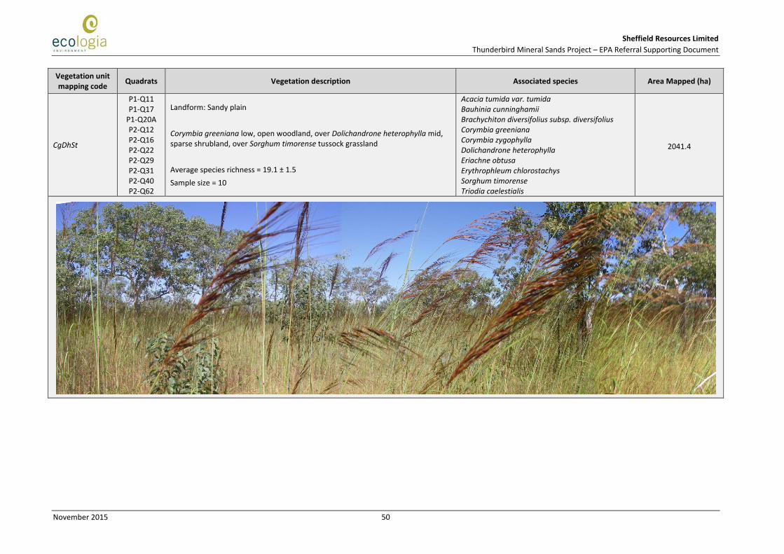
CgDhSt
P1-Q11 P1-Q17
P1-Q20A P2-Q12 P2-Q16 P2-Q22 P2-Q29 P2-Q31 P2-Q40 P2-Q62
Landform: Sandy plain Corymbia greeniana low, open woodland, over Dolichandrone heterophylla mid, sparse shrubland, over Sorghum timorense tussock grassland Average species richness = 19.1 ± 1.5 Sample size = 10
Acacia tumida var. tumida Bauhinia cunninghamii Brachychiton diversifolius subsp. diversifolius Corymbia greeniana Corymbia zygophylla Dolichandrone heterophylla Eriachne obtusa Erythrophleum chlorostachys Sorghum timorense Triodia caelestialis
2041.4

Sheffield Resources Limited Thunderbird Mineral Sands Project – EPA Referral Supporting Document
November 2015
51
Vegetation unit mapping code Quadrats Vegetation description Associated species Area Mapped (ha)
EcAtSt
P1-Q06 P2-Q14 P2-Q15 P2-Q26
P2-Q41C P2-Q49 P2-Q58 P2-Q66 P2-Q70
Landform: Sandy plain Erythrophleum chlorostachys low, open woodland, over Acacia tumida var. tumida mid, sparse shrubland, over Sorghum timorense open tussock grassland Average species richness = 24.1 ± 2.4 Sample size = 10
Acacia tumida var. tumida Aristida hygrometrica Dodonaea hispidula var. arida Erythrophleum chlorostachys Grevillea refracta subsp. refracta Microstachys chamaelea Sorghum timorense Spermacoce occidentalis Terminalia canescens Wrightia saligna
4064.4