botanical.survey of central pilbara uplands
TRANSCRIPT

BOTANICAL.SURVEY OF
CENTRAL PILBARA UPLANDS
Project (N709)
Progress Report 1999
Prepared by: Stephen van Leeuwen
Date: May 1999

PRECIS
BOTANICAL SURVEY OF CENTRAL PILBARA UPLANDS
Proiect N706
The botanical survey of Central Pi/bara upland sites commenced in 1995. During the past four years 80 upland sites have been visited across the Hamersley Range. These sites extend from Pannawonica in the west to Newman in the east, from Wittenoom in the north to Pararburdoo in the south. The upland sites range in elevation from 600 m to the height of Western Australian's highest mountain, Mt Meharry at 1 250 m.
On each of the sampled upland sites one 2.5 ha permanent benchmark quadrat was established. Within this quadrat all plant species present were recorded and voucher specimens collected for unknown taxa. Systematic intensive opportunistic flora sampling was also undertaken outside the quadrat over the entire upland site. A total of 265 person hours was accumulated in sampling upland sites.
A total of 260 identified species have been recorded from these upland sites. These species represent 124 genera in 53 families. The identification of many other taxa remains undetermined. A total of 1 018 specimens represented by over 2 500 vouchers have been collected under the auspices of this project. Many species of conservation, biological and taxonomic significance have been recorded during this project. The majority of the significant species are represented by . disjunctly distributed populations and typically represent new records for the Pilbara Biogeographical Region.
Preliminary, exploratory analyses of the specimen database and GIS atlas developed for this project indicate that elevation, bum history and edaphic (geology) considerations may be influencing the biogeographical patterning of upland species and plant communities across the Hamersley Range. Further investigative research and analysis is however required to verify the fidelity of such selective pressures and to examine the role of other processes (eg. moisture gradient - rainfall) in the distribution of upland flora throughout the Hamersley Range. Further analysis of the specimen database is also required to assess the CAR of the existing conservation reserve system in the project area.

Botanical Survey of Central Pilbara Uplands Project N709 Progress Report
TITLE OF PROJECT:
Botanical Survey of Central Pilbara Uplands
AGENCY:
Western Australian Department of Conservation and Land Management (CALM), CALMScience Division.
CHIEF INVESTIGATOR:
Dr Stephen van Leeuwen Research Scientist CALM Karratha P.O. Box 835 KARRATHA WA 6714 (08) 9143 1628
AIM OF PROJECT:
To comprehensively document the flora of upland sites within the Central Pilbara (Hamersley range) in order to facilitate an evaluation of the distribution of rare, geographically restricted and endangered plant species and to assist with the identification of areas of high floristic richness.
SCOPE:
1. Finalise systematic sampling of permanent quadrats on upland sites.
2. Finalise the compilation of results of all survey data collected during the project.
3. Finalise data entry and analysis of survey results.
4. Provide quantitative descriptions of species composition of each site sampled during the project.
5. Map the distribution of any species of conservation and biological significance reco~ded during the project.
6. Provide an analysis of plant species data collected during the project using multivariate and ordination techniques to determine patterns of species richness, turnover and distribution between upland sites. Include data for edaphic attributes and geological, geographic/terrain and fire history themes in such pattern analyses.
7. Finalise the development and presentation of management recommendations based on data collected during the surveys. Ensure that management recommendations promote the implementation of strategies which minimise deleterious
Stephen van Leeuwen, CALM May 1999 3

Botanical Survey of Central Pilbara Uplands Project N709 Progress Report
perturbations, especially for upland sites of biological and conservation significance.
PROGRESS TOWARDS COMPLETION OF SCOPE ITEMS:
During 1998 significant progress was made towards fulfilment of scope items for this project. Noteworthy achievements include the completion of all fieldwork, the sampling of 80 upland sites and the analysis of soil samples collected for surveyed sites. Progress towards fulfilment of scope items and the original project objectives are outlined below.
Scope 1:
A total of 80 upland sites have been sampled as part of this project (Figure 1 ). These sites cover the geographical extent of the Hamersley Range and represent the array of hilltop plant communities located throughout the project area. Surveyed uplands sites extend from Mt Rica (21 ° 59' 05" S, 116° 37' 30" E) near Pannawonica to Shovelanna Hill (23° 19' 55" S, 120° 01' 17" E) near Newman, an east-west traverse of 375 km. The north-south traverse covers approximately 200 km from Mt Flora (21 ° 46' 06'' S, 116° 59' 49") in the north to a low hill adjacent to Spearhole Creek (23° 28' 20" S, 119° 18' 1 O" E) in the south.
Surveyed uplands range in elevation from 600 m for Mt Rica to 1 250 m for Mt Meharry (22° 58' 55" S, 118° 35' 00" E). Forty five of the surveyed uplands had an elevation greater than 1 000 m. All major upland areas (> 1 000 m elevation) within the Hamersely Range were sampled. Twenty of the surveyed sites were within the Karijini National Park while 11 were on pastoral leases. The remainder were on vacant Crown land or other lease areas administered by the Crown.
On each of the sampled uplands a permanent benchmark quadrat was established within which all plant taxa were recorded. Wherever possible this quadrat is positioned to include the upland summit and adjacent areas incorporating 2.5 ha. Quadrats this size in the Pilbara captures approximately 95% of the plants species present within a given community (van Leeuwen and Start, unpublished data). To ensure uniformity in sampling effort across all sites quadrats were searched systematically for flora over a one person hour period. In addition to the systematic sampling, random opportunistic sampling was also undertaken over the entire upland site. This was achieved by walking over the site and opportunistically collecting and recording all plant species encountered. A minimum of two hours random opportunistic sampling was undertaken at each upland site. A total of 265 person hours were amassed sampling upland sites.
Soil samples were obtained from all surveyed upland sites. The samples, which comprised 1 kg of material, were an amalgamation of four sub-samples collected from the top 10 cm of soil in each corner of the 2.5 ha quadrat. Information gathered from the soil samples will provide an additional data set to help interpret patterns of species
Stephen van Leeuwen, CALM May 1999 4

• MtE!vire
•
·. • MtRica · 22
•
• •
•
• Mt Wall
-23
0 25
Kilometres
1 7
• • Mt Flora
•
117 I
•
50
• Mt Pyrton
•
• •
• Mt BrockmartV
\
• Mt Margaret
· 1· " ...
•
1 8
118 I
Mt Barricade
KARIJINI •
NATIONAL PARK •
•
~ Snowy Mountain
•
•
•
1 9
411.
'?A.tv •
t Robinson G /2 •
F er:-, , • •
I •
119
Figure 1 Location of the 80 surveyed upland sites within the Hamersley Range project area.
• Surveyed Uplands
• Uplands greater than 1 000 m.
•
Newman
•
120
120 I
22
23

Botanical Survey of Central Pilbara Uplands Project N709 Progress Report
composition and turnover between upland sites throughout the project area.
In summary the survey protocol employed to sample upland sites throughout the project area included the:
• establishment of a 50 x 50 m permanently marked quadrat on the summit of each upland site;
• sampling of all plants within the quadrat for a duration of one person hour;
• opportunistic sampling of the flora on fringing slopes and screes outside the quad rat over a minimum of two person hours;
• taking of a quadrat photograph from a fixed, marked point for future reference purposes; and
• the collection of a 1 kg soil sample.
Scope 2:
Processing, incorporation and databasing of plant specimens into the Pilbara Regional Herbarium is progressing. Duplicate specimens are also being forwarded to the Western Australian Herbarium and, in the case of specimens of taxonomic interest, vouchers will be forwarded to appropriate taxonomists at Eastern States and overseas institutions.
A total of 1 018 specimens represented by over 2 500 vouchers have been collected during this project from the 80 sampled upland sites. As many of the specimens represent poorly known, taxonomically troublesome and confounding species complexes (eg. Sida, Corchorus, Triodia, Senna) considerable effort is still required to provide identifications for many specimens. Assistance with specimen identification is being obtained from colleagues at the WA Herbarium and specialist taxonomists from Eastern States and overseas herbaria.
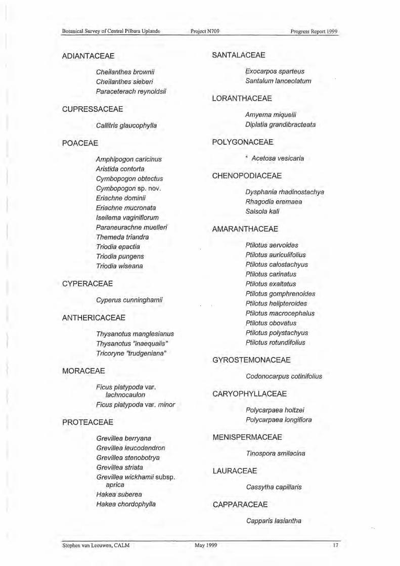
To data identifications have been confirmed for 260 species representing 124 genera in 53 families (Appendix 1 ). Several of the identified specimens represent poorly known, rare or disjunctly distributed taxa. The most floristically rich families are the Asteraceae, Goodeniaceae, Mimosaceae and Myrtaceae with in excess of 15 species. The most floristically rich genera were Acacia, Eremophila, Eucalyptus and Senna. The dominance of these families and genera are likely to change through the continued identification of numerous undetermined specimens, although their relative floristic importance will probably remain unaltered as they generally represent important constituents of the flora of arid inland Australia.
In addition to the 260 identified taxa an additional 133 taxa have only been provisionally identified. Several of these specimens are of conservation, biological or taxonomic significance and many represent rare, disjunctly distributed or novel taxon. For example, two Eucalyptus specimens possibly represent novel taxa not previously described in the scientific literature.
Stephen van Leeuwen, CALM May 1999 6

Botanical Survey of Central Pilbara Uplands Project N709 Progress Report
During the 1997-98 field sampling program several of the upland sites surveyed during previous trips were again sampled. This repeatedmeasures sampling regime was initiated to verify if the project's sampling protocol, which consisted of only a single visit to each upland site, was sufficient to comprehensively document an upland site's flora. Seven upland sites were sampled on two occasions while another two have been sampled on four occasions. Interrogation of floristic richness values obtained during sampling sessions indicated no significant difference in species numbers between sampling sessions for both the seven uplands sampled on two occasions (t7 = 0.28, P > 0.05) or the two uplands sampled on four occasions (X\= 2.37, P > 0.05).
All 80 soil samples have been analysed by the Chemistry Centre of Western Australia using standard analytic techniques. The chemical and physical attributes of the soil samples are presented in Appendix 2.
Scope 3:
Development of the specimen database for the project is ongoing and is continually being augmented as additional vouchers are incorporated into the Pilbara Regional Herbarium. The provision of determinations and confirmation of identifications from specialist taxonomists is also assisting with the development and refinement of this specimen database. To date the specimen database contains over 4 500 site records.
The development of the GIS atlas for the project has progressed considerably. The capture of fundamental themes related to relief, hydrology, infrastructure, land tenure and vegetation have been completed. The capture of special project orientated themes such as geology, in particular iron ore geology, have also been completed. Considerable work is still required however to capture project orientated themes related to burn history and the spatial variation in bioclimatic gradients across the project area. With the assistance of the Department of Land Administration, burn history records for the project area are being compiled for the past five years using NOAA remotely sensed imagery. It is anticipated that this data will be used to develop a wildfire threat analysis map which will delineate the probability of a 5° latitude-longitude grid square being burnt within the project area. Preliminary analysis of the data used to generate this GIS theme and the interrogation of the subsequent isopyric map implies that the risk of fire ignition and thus fire frequency is greatest along the northern escarpment of the Hamersley Range and attenuates promptly with progression south. There also appears to be an east-west gradient in the isopyric map with the risk-of-ignition greatest in the western portion of the Range. No trend between risk-of-ignition and elevation has been detected although data analysis is not yet complete.
Similarly, with the assistance of the Water and Rivers Commission and the Bureau of Meteorology, themes related to annual rainfall and average temperature are also being developed for the project area. It is anticipated that the isohyet map for the project area will show an
Stephen van Leeuwen, CALM May 1999 7

l Botanical Survey of Central Pilbara Uplands Project N709 Progress Report
appreciable north west to south east gradient in rainfall. Previous interpretations of annual rainfall undertaken by the Waters and Rivers Commission indicate that rainfall throughout the project area varies from an average of 350 mm annually - in the vicinity of Mt Margaret (21 ° 58' 24" S, 117° 50' 13" E), at the northern edge of the escarpment, to about 250 mm in the vicinity of Snowy Mountain (23° 24' 13" S, 118° 03' 53" E), on the southern edge of the project area. The Waters and Rivers Commission's isohyet data is too coarse to detect any relationship between elevation and rainfall across the project area.
Reliable, representative data on annual , average temperature across the project area is very limited with only five synoptic weather stations present (Newman, Pannawonica, Paraburdoo, Tom Price, Wittenoom). However, it is anticipated that noticeable gradients in temperature will be detected on isotherm maps, especially as a function of elevation and longitudinal gradients. The development of the temperature theme for the GIS atlas will be enhanced through the use BIOCLIM, a software package which will facilitate the determination of annual mean temperature estimates for each sampled upland site.
Scope 4:
Preliminary work has commenced _on the compilation of quantitative descriptions for the floristic composition and richness of the surveyed upland sites. Superficial, exploratory analyses of the data supports the proposition that edaphic considerations have a considerable impact on species distribution and the floristic composition of upland sites throughout the project area. These edaphic considerations are intrinsically the product of the geological setting with the most pronounced differences in floristic composition being apparent between the Proterozoic Brockman Iron Formation of the Hamersley geological group and the Archaean Bunjinah and Mount Jape Volcanics Formation of the Fortescue geological group.
The databasing of vegetation descriptions for sampled uplands is nearing completion. Exploratory analysis of this data indicates that most uplands (85%) are comprised of a Shrub Mallee or Open Shrub Mallee community over Low/Dwarf Scrub over Mid-Dense Hummock Grasses. This community type was particularly common on upland sites with an elevation above 1 000 m. In many of the sites below this elevation the mallee community was replaced by an Open Low Woodland overstorey. No attempt has been made to associate heterogeneity in vegetation community complexity with gradients in annual rainfall, annual temperature and burn history across the project area.
One environmental weed species, Ruby Dock (Acetosa vesicaria) , was recorded on several of the upland sites visited . This species has unfortunately become common in the Pilbara favouring disturbed sites associated with mining operations, particularly waste rock dumps and associated screes and batters. The species appears to be invading
Stephen van Leeuwen, CALM May 1999 8

Botanical Survey of Central Pilbara Uplands Project N709 Progress Report
some upland sites as a consequence of its wind dispersed seed and the inherent nature of upland sites which often comprise rock scree slopes.
Scope 5:
A database of plant species of conservation, taxonomic and biological significance has been developed for the GIS atlas. This database will be used to devise maps portraying the distribution of conservation and biologicallysignificant upland flora · across the project area. The database will contain distributional data collected during this project in conjunction with data obtained from records held by the Western Australian Herbarium and from the databases of resource companies and their consultants with interests in the project area.
At present, populations of significant upland flora have been recorded for the following species identified within the project area:
Acacia sp. West Angelas (M. E. Trudgen 16163) This recently recognised taxon, which superficially resembles Acacia hamersleyensis, has been collected from two upland sites during this project. There are four other populations known in the project area. All populations with the exception of one at Dales Gorge are on upland sites.
Brachychiton acuminatus This species is listed as a Priority Four taxon on CALM's Priority Flora list. The species is endemic to the Pilbara Biogeographical Region extending from the Burrup Peninsula through the Chichester Range to the Hamersley Range. The species has been recorded from twelve upland sites during this project.
Brachychiton gregorii This taxon has an extensive distribution throughout arid central Australia from Shark Bay and Norseman in Western Australia through the Great Victoria and Gibson Desert into north-eastern South Australia and the central Northern Territory. During this project the species has been recorded on ten upland sites. These sites represent disjunct outlying populations removed from the species main distribution.
Cryptandra monticola This Hamersley Range endemic is known from approximately 35 populations throughout the Hamersley Range. During this survey the species has been recorded from 20 upland sites.
Dampiera sp. Mt Bruce (M. E. Trudgen 1334) This undescribed taxon is listed as Priority Two on CALM's Priority Flora List. The taxon is endemic to the Hamersley Range where it is known from 16 populations. Ten of these populations were located during the course of this project.
Dampiera sp. Mt Meharry (M. E. Trudgen 1178) This undescribed taxon is listed as Priority Two on CALM's Priority Flora List. The taxon is endemic to the Hamersley Range where it is known from 18 populations. Sixteen of these populations were located during the course of this project.
Stephen van Leeuwen, CALM May 1999 9

Botanical Survey of Central Pi Ibara Uplands Project N709 Progress Report
Daviesia eremaea This species is on CALM's Priority Three rare flora list. The species has a distribution in the central sandy deserts of Western Australia and the Northern Territory where it principally grows in red sandy swales between dunes. Prior to the collection of this species from two uplands in the Hamersley Range as part of this project, the most westerly known population was in the Little Sandy Desert south of Rudall River. The two Hamersley Range populations are over 230 km removed from this desert population.
Eremophila "magnifica" This undescribed taxon, which may consist of two distinct subspecies, is endemic to the Hamersley Range. The taxon is listed on CALM's Priority Flora List as a Priority Three taxon. Prior to the commencement of this survey the taxon was known from 12 populations. An additional eight populations have been documented during this project.
Eucalyptus ewartiana This mallee has a distribution predominantly throughout the northern wheatbelt to Great Victoria Desert regions in southern Western Australia. Disjunct outlying populations were known from a few uplands within the Hamersley Range, namely Mt Newman, Mt Robinson and Mt Meharry. During this project the species has been recorded from ten upland sites, seven of which are new localities.
Eucalyptus pilbarensis This species is endemic to the Pilbara Biogeographical Region being almost entirely restricted to the Hamersley Range. The species is listed on CALM's Priority Flora List as a Priority Four taxon. Prior to this project the species was known from 13 populations. During this project the species has been recorded from ten new localities.
Hibbertia glaberrima This species is listed as a Priority Two taxon on CALM's Priority Flora list. The species was only known from Mt Bruce in Western Australia, although the species is also known from numerous populations in the MacDonnell Ranges, Northern Territory. During this project populations of H. glaberrima were located at 25 additional upland localities in the Hamersley Range.
Lamarchea sulcata This species was recorded from two upland sites during this project. These records represent the first two populations of this species in the Hamersley Range.
Melaleuca leiocarpa This species is common in spinifex and mallee communities of the Murchison and Coolgardie Biogeographical Regions of Western Australia. The record of this species on Mt Wall, obtained during this project, is the only collection from the Hamersley Range. This Mt Wall population is a disjunct outlier which is 180 km north of the next nearest population on Mt Augustus.
Stephen van Leeuwen, CALM May 1999 10

J
Botanical Survey of Central Pilbara Uplands Project N709 Progress Report
Newcastel/ia cephalantha This species is distributed throughout the Eremaean Botanical Province of Western Australia extending from Telfer to south of Wiluna and from Kumarina east to the Northern Territory border. The species is also found in the Northern Territory, Queensland and South Australia. This species has been recorded from eight upland sites during this project. These records represent the first for this taxon in the Hamersley Range and Pilbara Biogeographical Region . The populations located during this survey represent disjunct outliers which are approximately 180 km north west of the next nearest population. .
Newcastel/ia spodiotricha This species is found in arid regions of Western Australia, Northern Territory, Queensland and South Australia. Within Western Australia its distribution extends from the Edgar Range to Mugg an Rockhole (Warburton Range) near the Northern Territory border. The species has been recorded from one upland site during this project which is the first record on the taxon in the Hamersley Range and Pilbara Biogeographical Region. This population is a disjunct outlier located approximately 250 km west of the next nearest population in the Little Sandy Desert.
O/earia plucheacea This species is endemic to Western Australia occurring in the Gascoyne and Murchison Biogeographical Regions. This species is known from approximately eight populations throughout the two regions. The collection of this species from two upland sites during this project represents the first records of this taxon in the Hamersley Range and Pilbara Biogeographical Region. These disjunct outlying populations are about 220 km north east of the next nearest population on Mt Augustus.
Paraceterach reynoldsii Five new populations of this species have been located during this project. Until the commencement of this project no specimens of this Central Australian taxon were housed in the W. A. Herbarium, although it was reported in the literature as occurring in Western Australia.
Pimelea forrestiana This species has a distribution which until recently was centred on the Gascoyne and Murchison Biogeographical Regions, although the Type collection was made from Mt Pyrton in the Hamersley Range by John Forrest in 1869. Recent collections have confirmed that the species does occur in the Hamersley Range, although these records are infrequent. During this project the species has been recorded from 29 upland sites, including the Type locality.
Pimelea microcephala This species has a widespread distribution across Australia occurring in all mainland states. In Western Australia the species occurs from the North West Cape to the Nullarbor where it is usually found growing in shrublands on sand. One population
Stephen van Leeuwen, CALM May 1999 II

Botanical Survey of Central Pi Ibara Uplands Project N709 Progress Report
has previously been recorded in the Hamersley Range. During this project another population was located north of Mt Robinson.
Prostanthera campbel/i This species is endemic to Western Australia extending from the Ashburton to Avon-Wheatbelt Biogeographical Regions. Two populations were recorded from upland sites during this project. These populations represent the first records of this species in the Hamersley Range and Pilbara Biogeographical Region. The populations are disjunct outliers being approximately 220 km north east of the next nearest population on Mt Augustus.
Stenanthemum petraeum This recently described species has a distribution throughout central Western Australia from Mt Augustus eastwards to Warburton. The species is also known from the Petermann Range in the Northern Territory. This species has been recorded from four upland sites during this project. Prior to the commencement of this project this species had been collected on only one occasion in the Hamersley Range.
Taplinia saxatilis This woody herb is known from several populations throughout the Gascoyne and Murchison Biogeographical Regions. Prior to the collection of this species during this project from three Hamersley Range upland sites the most northern population for this species was on Mt Augustus.
Thryptomene wittweri This species is gazetted as Declared Rare Flora. The species has a peculiar distribution occurring on three hilltops throughout the Eremaean Botanical Province of Western Australia. The species is also known from Palm Valley in the Northern Territory. During this project the species was recorded on Mt Meharry, a previously known locality.
Thysanotus manglesianus This fringed lily is common in the transitional rainfall zone between the South-west and Eremaean Botanical Provinces. It has a range which extends from Meekatharra to Balladonia and is usually found growing in sandy soils. Three populations were located on upland sites during this project. The next nearest known population is on Mt Augustus, some 220 km further south.
Thysanotus 'inaequalis' This undescribed fringed lily is very poorly known but appears to have a distribution throughout the Murchison and Coolgardie Biogeographical Regions of Western Australia. The taxon has also been collected in South Australia. The nearest known population to the six located during this project is at Meekatharra, 400 km south of the Hamersley Range.
'Pi/bara trudgenii' ms This novel taxon is distributed through the Hamersley Range and Barlee Range in the Pilbara and Gascoyne Biogeographical Region, respectively. Prior to the commencement of this project this species was known from three localities. Two new populations were located during this project.
Stephen van Leeuwen, CALM May 1999 12

Botanical Survey of Central Pilbara Uplands Project N709 Progress Report
Many of the taxa not yet positively identified may also be of conservation, biological and taxonomic significance. This is particularly true for many of the unidentified specimens from the Goodeniaceae, Tiliaceae and Malvaceae and taxa of Eucalyptus and Eremophila. Many of these unidentified specimens may represent novel taxa which will require identification by specialist taxonomists before an assessment of their conservation . status can be made. Ongoing identification and specimen processing will clarify these problems.
Scope 6:
A comprehensive analyses of the specimen database, to clarify patterns of species distribution, turnover and richness throughout the project area, has not been attempted. Only superficial, preliminary analyses have been undertaken on the specimen databases. These analyses attempted to associate species richness with the location (latitude, longitude, elevation) of sampled upland sites. The results suggested the absence of a relationship between species richness and progression across the project area from west to east. Similarly, no association was detected in species richness along the northwest to southeast orientation of the Hamersley Range. However, a significant association (F6 , 78 = 4. 71, P < 0.001) was detected in species richness with progression across the project area from north to south. Upland sites towards the south of the Hamersley Range tended to have greater species richness than those to the north. This difference was most apparent between upland sites occurring south of 23° S and those north of 22° S. A possible explanation for this association may be related to burn history as subjectively, fires appear to be a more frequent event along the northern escarpment of the Range as a consequence of thunderstorm activity and orographic influences.
This detected association may also be attributed to the influence of elevation as upland sites north of 22° S had an average elevation of 780 m whereas sites south of 23° Shad an average elevation of 980 m. Support for this elevation proposition is also provided by the detection of a significant correlation between species richness and upland site elevation (r79 = 0.29, P < 0.01 ). Support was also forthcoming through comparisons of species richness between upland sites greater than and less than 1 000 m in elevation. The species richness of the higher elevation sites was significantly greater than those upland sites below an elevation of 1 000 m (t77 = 2.61, P < 0.01 ).
Exploratory investigation of soil analysis results indicate a strong clustering (cophenetic correlation, r = 0.85) of sites across the project area into four associations based on soil chemistry (Figure 2). The primary division in the dendrogram depicting this clustering can be attributed to significant differences in geological considerations between sites located on the Proterozoic Brockman Iron Formation and the Archaean Bunjinah and Mount Jape Volcanics Formations. Explanations for subsequent lower order divisions along the Proterozoic Brockman Iron Formation branch of the dendrogram are not as explicit,
Stephen van Leeuwen, CALM May 1999 13

Botanical Survey of Central Pilbara Uplands Project N709 Progress Report
however, tentatively these clusters may be attributed to differences in the mineralogy (ore type) of the Brockman Iron formation .
Scope 7:
-
0.10
Proterozoic Brockman Iron Formation
Archaean Bunjinah & Mount Jope Volcanics Formation
0. 19 Coefficient
0.29
Figure 2 Clustering dendrogram of similarities in soil chemical properties between 80 Hamersley range upland sites. The clustering undertaken used the Bray-Curtis association measure and the UPGMA fusion method (~ = 0.0).
Distributional data for flora species of biological and conservation significance is already being utilised for routine management and operational procedures within the Karijini National Park. Species distributional data has been incorporated onto Wildfire Threat Analysis maps for the National Park and areas immediately adjacent, especially in the proposed Mulgalands Natural Resources Management Area around Mt Robinson and Giles Point. The species distributional data has also been incorporated into operational plans, such as the Master Burn Plan for Karijini National Park. This plan details the strategic development of aerial buffers within the national park for the control and suppression of wildfires.
The specimen database developed during this project has been used to help justify the case for incorporating a significant parcel of vacant Crown land, adjacent to Karijini National Park into the conservation estate. The data has been used to highlight how the inclusion of floristically rich uplands (eg. Mt Robinson) will significantly augment the comprehensiveness of the reserve system in the project area.
Data collected during this project has also been used to assist with the environmental assessments on a number of resource developments in the project area, namely the Environmental Review and Management Plan for Robe Rive Iron Associate's West Angelas development and the
Stephen van Leeuwen, CALM May 1999 14

Botanical Survey of Central Pilbara Uplands Project N709 Progress Report
Public Environmental Review for BHP Iron Ore's Mining Area C proposal.
No formal proposals for reserve gazettal have been developed as part of this project, although the data has been used to strengthen the arguments for maintenance and the protection of existing proposals.
PLANNED ACTIVITIES TOWARDS COMPLETION OF SCOPE ITEMS:
The primary focus of work for the remainder of 1999 will be the identification of outstanding specimens, continued development of the specimen database together with the GIS atlas and the comprehensive analysis of these databases to detect biogeographical patterns in species distribution, composition and richness across the project area. At the completion of these tasks it will be possible to assess the CAR of the existing and proposed reserve system in the project area, identify possible threatening processes impinging on upland flora and make recommendations for future management and reserve acquisitions which promote the conservation of the botanical values of hilltops throughout the Hamersley Range.
* * * * * * * * * *
Stephen van Leeuwen, CALM May 1999 15

Botanical Survey of Central Pi Ibara Uplands Project N709
APPENDIX ONE
Appendix One
Vascular Plant Species
Botanical Survey of Central Pilbara Uplands
March 1999
This list of vascular plants includes all identified specimens collected
during the 1995 to 1998 field programs and subsequently identified
before 1 April 1999. Taxa are listed alphabetically in the order of
genus and species in their respective families. The family sequence
follows approximately the classification presented in Green (1985)
"Census of the Vascular Plants of Western Australia". Nomenclature
generally follows Green op. cit. and that employed by the Western
Australian Herbarium, apart from a few exceptions where recent
taxonomic revisions have suggested alternative treatments.
* Introduced species.
Stephen van Leeuwen, CALM May 1999
Progress Report
16
Botanical Survey of Central Pi Ibara Uplands
ADIANTACEAE
Cheilanthes brownii
Cheilanthes sieberi
Paraceterach reynoldsii
CUPRESSACEAE
Callitris glaucophylla
POACEAE
Amphipogon caricinus
Aristida contorta
Cymbopogon obtectus
Cymbopogon sp. nov.
Eriachne dominii
Eriachne mucronata
/sei/ema vaginiflorum
Paraneurachne muel/eri
Themeda triandra
Triodia epactia
Triodia pungens
Triodia wiseana
CYPERACEAE
Cyperus cunninghamii
ANTHERICACEAE
Thysanotus manglesianus
Thysanotus "inaequalis"
Tricoryne "trudgeniana"
MORACEAE
Ficus platypoda var. /achnocau/on
Ficus p/atypoda var. minor
PROTEACEAE
Grevil/ea berryana
Grevil/ea leucodendron
Grevil/ea stenobotrya
Grevillea striata
Grevil/ea wickhamii subsp. aprica
Hakea suberea
Hakea chordophyl/a
Stephen van Leeuwen, CALM
Project N709 Progress Report 1999
SANTALACEAE
Exocarpos sparteus
Santa/um /anceolatum
LORANTHACEAE
Amyema miquelii
Diplatia grandibracteata
POLYGONACEAE
* Acetosa vesicaria
CHENOPODIACEAE
Dysphania rhadinostachya
Rhagodia eremaea
Sa/so/a ka/i
AMARANTHACEAE
Ptilotus aervoides
Ptilotus auriculifo/ius
Ptilotus ca/ostachyus
Ptilotus carinatus
Ptilotus exa/tatus
Ptilotus gomphrenoides
Ptilotus he/ipteroides
Ptilotus macrocephalus
Ptilotus obovatus
Ptilotus polystachyus
Ptilotus rotundifolius
GYROSTEMONACEAE
Codonocarpus cotinifolius
CARYOPHYLLACEAE
Polycarpaea holtzei
Polycarpaea /ongiflora
MENISPERMACEAE
Tinospora smilacina
LAURACEAE
Cassytha capillaris
CAPPARACEAE
Capparis /asiantha
May 1999 17

Botanical Survey of Central Pilbara Uplands
Capparis spinosa
Capparis umbonata
C/eome viscosa
BRASSICACEAE
Lepidium platypetalum
Lepidium oxytrichum
PITTOSPORACEAE
Pittosporum phyl/iraeoides
SURIANACEAE
Stylobasium spathu/atum
MIMOSACEAE
Acacia acradenia
Acacia adoxa
Acacia aneura
Acacia arida
Acacia atkinsiana
Acacia. ayersiana
Acacia bivenosa
Acacia aff. catenulata
Acacia coriacea subsp. seriophyl/a
Acacia coriacea subsp pendens
Acacia cow/eana
Acacia dictyophleba
Acacia hamers/eyensis
Acacia hilliana
Acacia inaequilatera
Acacia kempeana
Acacia maitlandii
Acacia marramamba
Acacia monticola
Acacia pachyacra
Acacia pruinocarpa
Acacia pyrifolia
Acacia rhodoph/oia
Acacia spondylophyl/a
Acacia stowardii
Acacia aff. subtessarogona
Acacia synchronicia
Acacia tenuissima
Acacia tetragonophyl/a
Acacia validinervia
Stephen van Leeuwen, CALM
Project N709 Progress Report 1999
Acacia sp. West Angelas (M. E. Trudgen 16163)
CAESALPINIACEAE
Petalostylis labicheoides
Senna form taxon artemisioides
Senna cardiosperma
Senna ferraria
Senna form taxon g/utinosa
Senna form taxon he/msii
Senna form taxon luerssenii
Senna notabilis
Senna form taxon oligophyl/a
Senna p/eurocarpa var. augustifolia
Senna form taxon pruinosa
Senna form taxon sturtii
PAPILIONACEAE
Daviesia eremaea
Gastro/obium grandif/orum
Glycine tabacina
Gompho/obium po/yzygum
fndigofera "fractif/exa"
lndigofera colutea
/ndigofera georgei
fndigofera monophylla
lsotropis atropurpurea
Mirbe/ia viminalis
Rhynchosia minima
Swainsona maccullochiana
ZYGOPHYLLACEAE
Tribulus platypterus
Tribu/us astrocarpus
Tribu/us suberosus
POLYGALACEAE
Polyga/a chinensis
EUPHORBIACEAE
Euphorbia boophthona
Phyllanthus maderspatensis
CELASTRACEAE
Maytenus aff. cunninghamii
May 1999 18

Botanical Survey of Central Pilbara Uplands
SAPINDACEAE
Alectryon oleifolius
Atalaya hemiglauca
Dodonaea coriacea
Dodonaea lanceolata
Dodonaea peteolaris
Dodonaea viscosa subsp. angustissima
Dodonaea viscosa subsp .. mucronata
Dodonaea viscosa subsp. spatulata
RHAMNACEAE
Cryptandra monticola
Stenanthemum petraeum
Ventilago viminalis
TILIACEAE
Corchorus crozophorifolius
Corchorus laniflorus
Corchorus sidoides
Triumfetta appendiculata
Triumfetta chaetocarpa
Triumfetta clementii
Triumfetta leptacantha
Triumfetta micrantha
Triumfetta propinqua
MALVACEAE
Abutilon lepidum
Gossypium robinsonii
Hibiscus coati
Hibiscus goldsworthii
Hibiscus aff. haynaldii
Hibiscus leptocladus
Malvastrum americanum
Sida fibulifera
Sida "golden calys"
STERCULIACEAE
Brachychiton acuminatus
Brachychiton gregorii
Keraudrenia integrifolia
Keraudrenia nephrosperma
Rulingia rotundifolia
Waltheria indica
Waltheria virgata
Stephen van Leeuwen, CALM
Project N709 Progress Report 1999
DILLENIACEAE
Hibbertia glaberrima
VIOLACEAE
Hybanthus aurantiacus
THYMELAEACEAE
Pimelea forrestiana
Pimelea microcephala
MYRTACEAE
Calytrix carinata
Corymbia deserticola
Corymbia ferriticola
Corymbia terminalis
Corymbia aff. terminalis
Corymbia hamersleyana
Eucalyptus ewartiana
Eucalyptus gamophyl/a
Eucalyptus kingsmillii
Eucalyptus leucophloia
Eucalyptus pilbarensis
Eucalyptus rupullulans
Eucalyptus trivalvis
Eucalyptus "xerothermica"
Melaleuca leiocarpa
Thryptomene wittweri
HALORAGACEAE
Haloragis gossei
ARALIACEAE
Astrotricha hamptonii
APIACEAE
Daucus glochidiatus ·
Trachymene oleracea
Trachymene "pilbara"
OLEACEAE
Jasminum didymum subsp. lineare
ASCLEPIADACEAE
May 1999
Marsdenia australis
Rhyncharrhea linearis
19

Botanical Survey of Central Pilbara Uplands
Sarcostemma viminale subsp. austra/e
CONVOLVULACEAE
Eva/vu/us a/sinoides
Jpomoea aff. pes-caprae
Porana commixta
BORAGINACEAE
Halgania gustafsenii
Heliotropium heteranthum
Trichodesma zeylanicum
VERBENACEAE
C/erodendrum floribundum
CHLOANTHACEAE
Newcastelia cephalantha
Newcastelia spodiotricha
Spartothamnella teucriiflora
LAMIACEAE
Plectranthus intraterraneus
Prostanthera albiflora
Prostanthera campbe/Jii
SOLANACEAE
Nicotiana benthamii
Nicotiana occidentalis
So/anum centra/e
So/anum ferosissimum
Solanum horridum
Solanum lanceo/atum
Solanum Jasiophyllum
Solanum sturtianum
ACANTHACEAE
Rostel/ularia adscendens subsp. adscendens
Rostellularia adscendens subsp. clementii
MYOPORACEAE
Eremophila cuneifolia
Eremophila exilifolia
Eremophi/a forrestii
Eremophila fraseri
Stephen van Leeuwen, CALM
Project N709 Progress Report 1999
Eremophila /atrobei
Eremophi/a /ongifolia
Eremophi/a "magnifica" subsp. "magnifica"
Eremophila "magnifica" subsp. "ve/utina"
RUBIACEAE
Hedyotis crouchiania
Psydrax latfolia
Psydrax suaveolens
Pomax aff. umbel/ata
CUCURBITACEAE
Mukia maderaspatana
LOBELIACEAE
Lobelia heterophylla
GOODENIACEAE
Brunonia australis
Dampiera candicans
Dampiera sp. Mt Bruce (M. E. Trudgen 1334)
Dampiera sp. Mt Meharry (M. E. Trudgen 1178)
Goodenia cusackiana
Goodenia heterochila
Goodenia prostrata
Goodenia stobbsiana
Goodenia trichophyl/a
Goodenia triodiophyl/a
Scaevo/a acaciodes
Scaevo/a browniana
Scaevola parvifolia subsp pilbarae
Velleia connata
ASTERACEAE
* Bidens pilosa
Ca/ocepha/us sp. Wittenoom (A. S. George 1082)
Ca/otis eremaea
Calotis hispidu/a
Calotis mu/tica/us
Chrysocephalum pterochaetum
Chrysocephalum semica/vum
Chrysogonum trichodesmoides
May 1999 20

Botanical Survey of Central Pilbara Uplands
O/earia plucheacea
O/earia sturtii
O/earia xerophila
"Pilbara trudgenii"
Pterocau/on serru/atum var. velutinum
Pterocau/on sphaeranthoides
Rhodanthe he/ichysoides
Stephen van Leeuwen, CALM
Project N709
May 1999
Progress Report 1999
Senecio magnificus
Sigesbeckia orientalis
Streptoglossa bubakii
Taplinia saxati/is
Vittadinia virgata
Wedelia sp. Hamersley (A. S. Western 8444)
21

Botanical Survey of Central Pilbara Uplands Project N709 Progress Report
APPENDIX TWO
Chemical and physical attributes of the soils from 80 upland sites in the Hamersley Range project area.
EC pH pH Org C N P Site (1 :5) (H,0) (CaCI,) (W/B) (total) (total)
No. mS/m % % mg/kg
2
3
4
5
6
7
8
9
10
11
12
13
14
15
16
17
18
19
20
21
22
23
24
25
26
27
28
29
30
31
32
33
34
35
36
37
38
39
40
2
2
12
2
2
2
2
2
2
2
16
2
2
5
2
2
3
4
6.3 5.1
5.6 4.4
6.3 5.2
6.0 5.3
6.4 5.3
5.4 4.2
6.4 5.3
6.0 4.7
6.3 5.1
5.8 4.7
5.9 4.9
6.1
6.1
4.8
4.8
5.8 4.6
6.2 4.8
7 5.8
6.5 5.3
5.7 5.1
5.4 4.3
5.6 4.6
6.6 5.5
6.3 5.1
5.7 4.5
5.9 4.7
5.4 4.4
6.1 5
6.2 4.8
6 4.8
6 4.8
5.3 4.2
5.6 4.4
6.1 5.3
6.1 5
6.5 5.5
6.3 5
6.9 5.9
5.2 4.2
6.1 5
5.9 4.7
6 4.9
Stephen van Leeuwen, CALM
1.06 0.071 437
1.22 0.079 365
0.60 0.037 297
1.73 0.103 442
2.50 0.149 458
2.17 0.123 385
1.02 0.049 482
1.47 0.083 788
0.84 0.041 458
1.99 0.117 437
1.54 0.084 405
1.35 0.081 340
0.27 0.033 300
0.31 0.031 277
0.54 0.051 304
0.7 0.068 187
0.81 0.075 189
1.51 0.133 280
0.86 0.075 382
1.37 0.087 313
0.79 0.061 306
0.64 0.054 381
0.54 0.041 354
0.58 0.042 315
0.55 0.046 297
1.55 0.098 500
0.78 0.05 432
0.7 0.051 420
0.83 0.071 442
0.9 0.064 382
1.27 0.081 407
1.96 0.125 416
1.35 0.116 312
1.12 0.101 406
0.8 0.067 262
1.31 0.13 215
2.12 0.155 294
1.05 0.093 387
1.12 0.096 382
1.96 0.163 476
P Ca1 Mg Na K Al Mn Sand Silt Clay (HCO,) (exch) (exch) (exch) (exch) (exch) (exch)
mg/kg me¾ me¾ me% me¾ me¾ me¾ % % %
6
6
9
7
6
4
11
4.46' 1.08' 0.04' 0.32' 0. 75' 0.19' 65.5 18.5 16.0
1.73' 0.44' 0.02' 0.24' 0.03' 0.13' 60.0 24.0 16.0
4.42' 2.64' 0.02' 0.49' 0.02' 0.24' 65.0 17.5 17.5
8.06' 1.93" 0.17' 0.34' 0.04' 0.15' 63.5 22.0 14.5
8.80' 1.81' 0.03' 0.25' 1.26' 0.12' 55.5 28.0 16.5
1.15' 0.46' <0.02 0.26' 0.02' 0.13' 69.5 17.0 13.5
6.68' 1.47' <0.02 0.29' 0.10• 0.19' 57.0 22.0 21.0
20 5.21' 1.89' 0.03' 0.48' 0.03' 0.15' 65.5 20.5 14.0
7 4.78' 0.96' <0 .02 0.18' 0.32' 0.33' 53.5 30.0 16.5
8
6
4
6
4
4
4
4
7
7
5
4
8
6
5
3
4
7
7
5
4
4
3
4
7
7
2
3
5
3
5
6.86' 1.20' 0.02• 0.38' 0.08' 0.17' 74.0 10.5 15.5
5.36' 0.82' <0 .02 0.22• <0.02 0.03' 55.0 25.5 19.0
3.46' 2.80' 0.03' 0.29' <0.02 0.03' 55.0 25.5 19.0
1.51' 0.71' 0.22' <0.02 0.05' 0.08' 82.5 8.5 9
1.25' 0.49' 0.17' 0.02" 0.13' 0.08' 81 .5 9.5 9
3.13' 1.01' 0.26' 0.02' 0.08' 0.04' 72 15.5 12.5
7.66' 5.02' 0.50' 0.04' 53 22.5 24.5
4.64' 2.26' 0.55" 0.02' 67.5 16.5 16
6.88' 2.80' 0.49' 0.05' 0.03' 0.36' 57 17 26
O_j9• 0.11 ' 0.12' 0.02' 0.80' 0.05' 78.5 13.5 8
3.48' 0.76' 0.22' 0.03' 0.24' 0.07' 72 13.5 14.5
4.28' 1.21' 0.34' 0.02' 73 13 14
2.99' 0.81' 0.26' <0 .02 0.04' 0.02' 81 .5 10.5 8
2.19' 0.64' 0.24' <0 .02 0.16' 0.09' 70.5 12.5 17
1.58' 0.71' 0.24' 0.02' 0.15' 0.07' 75 12 13
0.61' 0.24' 0.15' 0.02' 0.41' 0.04' 80 11 .5 8.5
5.34' 1.60' 0.25' 0.05' 0.05' 0.10• 68 16.5 15.5
2.90' 1.04' 0.16' <0.02 0.17' 0.05' 78.5 12 9.5
2.88' 1.11' 0.21' <0.02 0.08' 0.06' 66 17.5 16.5
1.91' 0.60' 0.22' 0.02' 0.18' 0.03' 74 16 10
0.86' 0.33' 0.12' <0.02 0.79' 0.08' 70.5 15 14.5
2.49' 0.76' 0.23' <0.02 0.48' 0.14' 65 17 18
9. 75• 1. 72' 0.28' 0.09' 0.02' 0.06' 65.5 15 19.5
5.83' 2.24' 0.54' 0.04' 0.05' 0.09' 58.5 19 22.5
7.54' 0.94" 0.34' 0.03' 0.02• 0.05' 62 17.5 20.5
4.33' 2.50' 0.48' 0.03' 0.03' 0.06' 68 15.5 16.5
8.29' 3.48' 1.11' 0.07' 50 28.5 21.5
2.58' 0.96' 0.35' 0.03' 0.39' 0.24' 70 11.5 18.5
4.84' 1.12' o.3o' <0.02 o.o3' 0.1 o• 69 14 11
3.33' 0.93' 0.21 • 0.02' 0.14' 0.08' 69 12.5 18.5
5.66' 0.91' 0.28' 0.02' 0.23' 0.04' 66 26.5 7.5
May 1999 22

Botanical Survey of Central Pilbara Uplands
EC pH pH Org C N P Site (1 :5) (H,O) (CaCl2) (W/8) (total) (total)
No. mS/m % % mg/kg
41
42
43
44
45
46
47
48
49
50
51
52
53
54
55
56
57
58
59
60
61
62
63
64
65
66
67
68
69
70
71
72
73
74
75
76
77
78
79
80
2
3
2
2
19
4
5
3
2
4
4
2
2
2
2
2
22
2
5.8 4.5
6.5 5.3
5.8 4.5
5.8
5.8
5.5
4.5
4.6
4.3
5.4 4.3
5.1 4.1
5.9 4.8
7 6.2
6.5 5.4
5.6 4.4
5
5
4.9
5.7
5.3
4.9
4
4
4.4
4.8
4.4
4
5.5 4.4
6.3 5
5.7 4.4
5.7 4.5
5.4 4.2
5
5.1
5.6
5.6
4
4.2
4.4
4.8
5.6 4.4
6.3 5.3
6.3
5.4
6.1
6.3
6.1
5
4.3
4.9
5.1
4.7
6.2 5.1
6.2 5
6.3
4.8
5
4.3
6.2 5
5.9 4.7
1.09 0.084 437
0.9 0.078 385
0.61 0.055 182
0.79 0.071 186
0.88 0.071 362
0.75 0.06 311
0.93 0.071 278
1.9 0.085 289
1.75 0.086 360
1.66 0.134 458
1.28 0.093 339
0.7 0.068 522
0.58 0.059 358
2.04 0.086 285
3.4 0.141 369
2.6 0.13 307
1.54 0.097 338
1.69 0.091 305
0.8 0.067 215
0.61 0.072 256
0.36 0.041 216
0.42 0.049 269
0.49 0.05 303
0.86 0.061 434
2.5 0.11 373
0.77 0.064 261
1.49 0.084 299
0.55 0.049 320
1.02 0.112 333
1 .01 0.084 350
1.4 0.11 372
0.78 0.06 424
1.17 0.085 386
0.95 0.067 412
1.91 0.146 386
1.35 0.094 390
1.34 0.086 362
1.44 0.093 405
1.39 0.092 380
1.3 0.083 496
Project N709 Progress Report
APPENDIX TWO
P Ca1 Mg Na K Al Mn Sand Silt Clay (HCO,) (exch) (exch) (exch) (exch) (exch) (exch)
mg/kg me% me% me% me% me% me% % % %
6
3
2
1.68' 0.57' 0.18' <0 .02 0.29' 0.06' 72 13 15
5.38' 1.48' 0.29' <0.02 0.02' 0.07' 69.5 14.5 16
1.10' 0.29' 0.24' <0.02 0.20' 0.09' 88 4 8
<2 2.61' 0.57' 0.30' 0.02' 0.16' 0.08' 80.5 6 13.5
4 2.20' 0.54' 0.24' <0 .02 0.20• 0.06' 73.5 12 14.5
5
4
2
3
9
7
18
3
2
8
4
6
3
2
4
3
3
4
8
6
4
9
1.11' 0.40' 0.14' 0.02' 0.61' 0.06' 71.5 16.5 12
0.92' 0.41' 0.14' <0,02 0.61' 0.05' 69.5 16,5 14
1.55' 0.54' 0.24' 0.03' 0.44' 0.09' 75.5 8.5 16
3.06' 0.99' 0.33' 0.03' 0.08' 0.09' 68 14.5 17.5
7.65' 1_70• o.80' 0_03• 63 18.5 18.5
4.64' 0.86' 0.35" <0.02 73.5 13 13.5
1.85' 0.56' 0.31' 0.02' 0.24' 0.12' 72 13 15
0.31' 0.09' 0.14' <0.02 1.09' 0.03' 75 13 12
0.77' 0.33' 0.26' 0.04' 0.84' 0.10' 75.5 8.5 16
5. 72• 1.28' 0.41 • 0.1 s• 0.20• 0.06' , 65.5 13 21.5
4.64' 2.18' 0.43' 0.06' 0.08' 0.21' 59.5 15 25.5
4.74' 1.12' 0.37' 0.10' 0.22' 0.08'
1.23' 0.51' 0.26' 0.02' 0.75' 0.05'
68
74
1.13' 0.53' 0.19' <0.02 0.27' 0.07' 77
13.5 18.5
9 17
10 13
2.54' 0.86' 0.40' 0.02' 0.03' 0.07' 78.5 9.5 12
1.17' 0.63' 0.22' 0.04' 0.17' 0.09' 78 10.5 11 .5
1.51' 0.57' 0.29' 0.02' 0.16' 0.10' 78 10.5 11 .5
0.82' 0.38' 0.17' <0.02 0.45' 0.09' 77 11 12
0.68' 0.35' 0.17' 0.03' 0.79' 0.04' 72 10.5 17.5
1.62' o.52' o.36' o.o7' o.56' 0.1 o• 73.5 11 .5 16
1.48' 0.42' 0.19' 0.02' 0.34' 0.11• 79.5 10 10.5
3.60' o.96' 0.43' o.o4' 0.08' 0.1 9' 74 g 17
10 1.36' 0.64' 0.26' <0.02 0.21' 0.07' 72.5 11.5 16
10 6.20' 1.52' 0.49' 0.02• 0.03' 0.08' 63.5 23 13.5
6
8
4.78' 1.56' 0.32' 0.02' 0.04' 0.06' 66.5 19 14.5
3.75' o.68' 0.28• 0.02• 0_42• 0.23' 68 15 17
10 4.12• 1.12• 0.23' 0.02• 0.06• 0.08' 70 14.5 15.5
4 6.64' 1.43• 0.35' 0.04' 0.03' 0.10' 68 17.5 14.5
10 4.98' 1.77' 0.26' o.o3' 0.16' 0.08' 63.5 20 16.5
6
7
8
11
10.14' 2.12• 0.42• 0.02• o.o4' 0.15' 57 24.5 18.5
7.34' 2.09' 0.30' 0.02' 0_04• 0.11' 61 .5 23 15.5
8.22' 1.59' 0.30' <0 .02 0.03' 0.09' 62.5 20 17.5
4.82• 1.01• o.31' 0.12• o.34' 0.11• 59.5 18.5 22
8 6.40' 2.02' 0.27' 0.13' 0.05' 0.11' 63.5 21 15.5
10 4.13' 1.07' 0_27• <0.02 0.26' 0.09' 68 19.5 12.5
Note: Methods used in determination of exchangeable cations: a extracted in 1 M NH4CI, pH 7.0. b extracted in 0.1 M BaCI2_
Stephen van Leeuwen, CALM May 1999 23