written statement by dr. kathryn d. sullivan...
TRANSCRIPT
1
WRITTEN STATEMENT BY DR. KATHRYN D. SULLIVAN
ASSISTANT SECRETARY OF COMMERCE FOR ENVIRONMENTAL OBSERVATION AND PREDICTION AND
DEPUTY ADMINISTRATOR NATIONAL OCEANIC AND ATMOSPHERIC ADMINISTRATION
U.S. DEPARTMENT OF COMMERCE HEARING TITLED
FROM NPOESS TO JPSS: AN UPDATE ON THE NATION’S RESTRUCTURED POLAR WEATHER SATELLITE PROGRAM
BEFORE THE SUBCOMMITTEE ON INVESTIGATIONS AND OVERSIGHT
AND SUBCOMMITTEE ON ENERGY AND ENVIRONMENT
COMMITTEE ON SCIENCE AND TECHNOLOGY U.S. HOUSE OF REPRESENTATIVES
September 23, 2011
Good morning Chairman Broun and Chairman Harris, Ranking Member Edwards and Ranking Member Miller, and Members of the Subcommittees. My name is Dr. Kathryn D. Sullivan. I am the Assistant Secretary for Environmental Observation and Prediction for the Department of Commerce’s National Oceanic and Atmospheric Administration (NOAA). Thank you for the opportunity to join David Powner from the Government Accountability Office (GAO), and Chris Scolese from the National Aeronautics and Space Administration (NASA) at today’s hearing. Satellites and NOAA’s Mission NOAA’s ability to succeed in its mission to provide science, service, and stewardship to the Nation is fundamentally dependent upon information derived from NOAA’s fleet of operational satellites. NOAA maintains two types of environmental satellites, polar-orbiting and geostationary satellites. These are part of NOAA’s integrated observing system, which includes satellites, radars, surface automated weather stations, weather balloons, sounders, buoys, instrumented aircraft, and other sensors, along with the data management infrastructure needed to maintain this system. This integrated system is the foundation upon which NOAA works towards achieving our four main goals – a weather-ready Nation, climate adaptation and mitigation, healthy oceans, and resilient coastal communities and ecosystems. Overview of NOAA’s Satellite Mandate The Nation relies on NOAA’s satellites and information as a key part of the global observing network. NOAA satellites and information services are a critical component of the observing, modeling, and computing resources needed to produce weather forecasts, watches, and warnings. NOAA satellites and the observations they gather are key national infrastructure that help protect lives and property and add immense value to the national economy. Uninterrupted flow of data from NOAA satellites is required to support two Department of Commerce Primary Mission

2
Essential Functions,1
which have been approved by the National Continuity Coordinator, thus making NOAA satellites not just NOAA priorities but also national priorities. NOAA is investing now to ensure that the Nation can continue to rely on these critical observations in the future. These observations and the derived products and services allow the Nation to prepare effectively for and deal with severe weather and other environmental phenomena. NOAA has been successfully developing, acquiring and managing its satellites and their operations for over 50 years. We have adapted to meet new challenges and have learned from past setbacks. We are poised to successfully meet our mission because we have an excellent team in place with strengths in program management and the development and implementation of successful end-to-end systems and a strong partnership with NASA. NASA is a world leader in satellite development and acquisition.
NOAA’s two major satellite programs each play critical roles in providing environmental information to the Nation. The two systems provide complementary observational data required to support the Nation’s forecasting and environmental monitoring capabilities. NOAA’s Geostationary Operational Environmental Satellite’s (GOES) are used for short-term weather forecasting and severe storm tracking. These are the satellites that continuously watch over the Western Hemisphere providing images of severe weather events such as Hurricane Irene and Tropical Storm Lee that are seen by millions of Americans everyday in their local or national media outlets. GOES-P (now called GOES-15), the last of the current GOES series, was launched in early 2010. NOAA is currently acquiring its next generation geostationary satellites, the GOES-R series. GOES-R is currently scheduled for launch in 2015 to provide uninterrupted geostationary satellite coverage over the Western Hemisphere before the end of GOES-15’s projected life. NOAA’s Polar-orbiting Operational Environmental Satellite (POES) series provides surface and atmospheric information over the entire Earth. Placed in the afternoon orbit, POES are crucial for NOAA’s long-term weather predictions and climate monitoring and modeling. The last NOAA POES was launched in early 2009. NOAA is developing its next generation polar-orbiting satellites - the Joint Polar Satellite System (JPSS) - to provide continuity of polar-orbiting observations, as well as planned improvements over the 1980’s POES technology. The decision to pursue the instrument improvements for JPSS was based on demonstrated benefits to NOAA’s weather forecasting mission from operational use of data from NASA’s research and development Earth Observing System (EOS) satellites Aqua, Terra, and Aura and the European Organisation for the Exploitation of Meteorological Satellites (EUMETSAT) Metop series of satellites. Following the launch of NASA’s Aqua and Terra satellites, NOAA worked to successfully incorporate their data into its numerical weather prediction models and
1 PMEF DOC-2: Collect and provide the Nation with critical intelligence data, imagery, and other essential information for predictive environmental and atmospheric modeling systems and space-based distress alert systems by operating NOAA-controlled satellites, communications equipment, and associated systems. PMEF DOC-3: Provide the Nation with environmental forecasts, warnings, data, and expertise critical to public safety, disaster preparedness, all-hazards response and recovery, the national transportation system, safe navigation, and the protection of the Nation’s critical infrastructure and natural resources.

3
will continue to do so until their end-of-lives. The improvements to model output and forecast skill were so impactful that NOAA made the decision to develop its next generation polar-orbiting satellites to transition these improvements onto NOAA’s operational platform. The first of these instruments will be flown on NASA’s National Polar-orbiting Operational Environmental Satellite System (NPOESS) Preparatory Project (NPP) mission, which will continue critical EOS global change measurements and reduce risk on JPSS. JPSS and the DoD counterpart – the Defense Weather Satellite System (DWSS) are the successor programs to the former NPOESS Program. The NPOESS Program was dissolved in early 2010 because it had an ineffective program management structure and it experienced developmental challenges resulting in delays in acquisition schedules and cost overruns, which resulted in significant slips in the launch date of the NPP satellite as well as the first NPOESS satellite. In February 2010, the Administration announced its decision to restructure the NPOESS program into the separate defense and civil polar-orbiting satellite programs, DWSS and JPSS, respectively. The announcement also reflected the decision to use NPP data in NOAA’s operational weather models. NPP is expected to provide a bridge from NOAA POES to JPSS. NPP is currently scheduled for launch next month, October 2011. Importance of Polar-orbiting Satellites to the Nation The year 2011 has already established itself in the record books as a historic year for weather-related disasters.
• The states in the southern United States, from Arizona through Florida, are currently experiencing record-breaking drought and are facing tremendous vulnerability to wildland fires.
• The states along the East Coast, from North Carolina to Vermont, are recovering from the effects of Hurricane/Tropical Storm Irene and Tropical Storm Lee.
• Communities in Missouri (Joplin) and Alabama (Tuscaloosa) are still coping with the aftermath of the spring tornados.
• States along the Mississippi basin, from Illinois to Louisiana, experienced record breaking floods in March and April, from a combination of heavy precipitation and the melting of a higher-than-normal snowpack.
• At the same time, Minnesota experienced significant flooding along the Red River.
In all of these instances, NOAA provided accurate forecasts and warnings to emergency managers and affected populations that these extreme weather events would occur, and that they should make preparations to minimize the impact of these pending events on lives and property. NOAA’s environmental predictive capabilities, which support accurate forecasts and warnings, are underpinned by four foundational pillars – observations, computer models, research, and our people. Polar-orbiting satellites, including NOAA polar-orbiting satellites, NASA Earth Observing System, and NOAA instruments that fly on European weather satellites, provide over 80 percent of the observational data for the numerical weather prediction models. The output from these models supports the 3- to 7-day weather forecasts on which Americans, businesses, and industry have come to rely. Retrospective analyses of what the weather forecast would have been for the February 6, 2010

4
“Snowmageddon” storms without the NOAA polar-orbiting satellite data in the afternoon orbit has crystallized for us just how important these data are to protecting lives, property, and critical infrastructure from these severe weather events. NOAA’s forecast skill is the combined result of advances in computing capability, improved modeling and data assimilation methods, and full and timely access to data from the observing system.
At 5 days before the event, NOAA issued a forecast to the public, state, and local governments that a major snow storm would occur with predictions of snowfall between 15-18 inches. While the actual snowfall was 15-22 inches, if NOAA had not had access to polar-orbiting satellite data in the afternoon orbit, the forecast would have been for 7-10 inches of snow, an under-forecast
of the snowfall by at least 10 inches. The impact would have been much more severe and widespread: many more aircraft and airline passengers would have been stranded; an increased amount of ground commerce would have been halted with no mitigation plans; populations, municipalities, and state governments would have been unprepared for the paralyzing snow-depth. In addition to providing the foundational data needed to support accurate weather forecasting in the near-term, data and information from JPSS are important for predictions from 2 weeks to about 3 years. Weather forecasts and longer-term predictions are critical for smart and efficient planning in many sectors of the economy. In fact, a recent study concluded that the aggregate dollar amount of variation in U.S. economic activity associated with weather variability could be 3.4%, or $485 billion per year of the 2008 gross domestic product.2
Some of these sectors include:
Aviation: Polar-orbiting satellites’ value to commercial and general aviation comes from providing atmospheric profiles of temperature, moisture, and pressure to forecast models, in the use of satellite images in data-sparse areas, through volcanic ash advisories, and by the relay of distress signals from emergency beacons. Emergency preparedness: Advance warning of extreme events in the critical planning period 3 days and beyond would be significantly diminished without polar-orbiting satellite data in the
2 Lazo, J.K., Lawson, M., Larsen, P.H., and Waldman, D.M., U.S. Economic Sensitivity to Weather Variability. Bulletin of the American Meteorological Society, June 2011, pp. 709-720
5
afternoon orbit. Sounding data in forecast models provide products for severe weather, drought, and flood forecasting. High-resolution imagery can detect fires or other hazards when polar-orbiting satellites provide images of opportunity in data-sparse areas. Polar-orbiting satellite data are also important for longer term predictions for example with the climate outlook that alerted the upper Missouri River and central Mississippi River basins in January that the spring flood potential was very high, allowing decision-makers to begin flood preparations and recovery effort planning. Agriculture: JPSS will provide continuity of critical data for monitoring vegetation conditions in drought and flood areas. JPSS vegetative products will be a great improvement over current capabilities. This will allow the U.S. Department of Agriculture (USDA), NWS, and global agricultural communities to better assess and predict changes in crop yields. This in turn will have a considerable economic and humanitarian impact through improved food security, reduction of agricultural market volatility, and more effective hunger relief efforts. Energy: Reliable and accurate predictions from shorter to longer time horizons, which rely on polar-orbiting satellite data are useful to urban planners working energy efficiency plans including solar and renewable, and to the entire energy industry. Marine Operations (shipping, fishing, and recreational boating): Polar-orbiting satellites are valuable in providing atmospheric profiles of temperature, moisture, and pressure to the forecast models in order to identify areas of warm sea surface temperature. These areas are key indicators of regions of possible tropical cyclone development. Polar-orbiting satellite images of opportunity are valuable in support of commercial shipping and recreational boating that occurs in open ocean areas and northern ports, where geostationary imagery may not be available. Polar-orbiting satellite data are also important for short-term and longer-term global forecasts and predictions that affect marine operations and activities. An example of this short-term climate outlook is the 18- to 24-month look at the phases of El Niño (or La Niña) and how it will affect precipitation and temperature patterns over the United States for upcoming seasons, or how they will likely affect the various fisheries. National Security and Defense: Military users rely on data from both the DoD’s and NOAA’s operational polar-orbiting weather satellites to provide decision dominance for 24/7 operations. Timely high resolution satellite imagery over foreign data sparse areas assists in "go/no-go" decisions for helicopter, drone, and other counter-terrorist operations. Military weather models derived from polar orbiting satellite data also guide deliberate planning for army and naval maneuver, flight routing and attack profiles, humanitarian operations and troop deployments. The Nation is at risk of having degraded weather forecasts and other important services because of a projected gap in access to critical NOAA polar-orbiting data. This projected gap is due to the lack of adequate, timely, and stable appropriated funds to develop and launch the JPSS satellite by mid-2016, before NPP has reached the end of its projected life. NOAA and NASA have concluded that the lack of adequate funds is the major challenge to achieving JPSS mission success as envisioned by the Administration’s February 2010 decision. The FY 2011 Yearlong Continuing Resolution (P.L. 112-10) did not provide the JPSS Program with the $1.060 billion requested in the FY 2011 President’s Budget. This has resulted in a

6
much greater risk of experiencing a data gap when the NPP satellite reaches the end of its projected life in mid-2016. Currently, the launch date of JPSS-1 is the first quarter of FY 2017 provided we receive full funding of the President’s FY 2012 Budget Request. Appendix A provides a comparison of the launch schedules based on the Administration’s February 2010 decision and the launch schedule as a result of the FY 2011 enacted amounts. Accomplishments since the inception of the JPSS Program Since the Administration’s announcement of JPSS in February 2010, NOAA, in collaboration with NASA, has made considerable progress transitioning to the JPSS program. It has established the necessary workforce and organizational structure, and instituted proper program management to achieve the civil mission success requirements that had eluded the previous NPOESS program. Following the decision to restructure the NPOESS program, NOAA continues to work towards implementing a successful program leveraging the efforts completed during the NPOESS era. To achieve this, NOAA has focused on the following three areas. Transition of JPSS Elements • NOAA and NASA have strategically maximized FY2011 resources towards the launch of the
NPP mission scheduled for the end of October. NPP is expected to be the bridge between NASA’s current EOS satellites and NOAA’s current aging polar-orbiting satellites and NOAA’s future polar-orbiting satellite system, JPSS, and will serve as a test for the application of the products and services from the technologically advanced instruments.
• NOAA and NASA have successfully transitioned all JPSS-relevant contracts for instrument development from the NPOESS contract to NASA management, which allows for proper Government oversight of the work to ensure it meets NOAA and NASA standards.
• NOAA and NASA successfully transitioned the full NPOESS ground system contract while making significant progress to meet the milestones required in preparation for the launch of NPP. The final phase of ground system testing was completed in August 2011, and NPP arrived safely in California only a few weeks ago where it is scheduled for launch in October. The ground system supports operations, data processing, and data distribution for both JPSS and DWSS, as well as other satellites.
Workforce and Organizational Structure • NOAA and NASA have fully staffed the JPSS Program Office with competent and
experienced staff, leveraging the expertise contained in the former NPOESS Integrated Program Office to implement a smooth transition.
Program Management • Alignment with a proven development and acquisition center: NOAA has aligned the JPSS
program with NASA, a proven developer of spaceflight systems. Time and again, this partnership has proven to be successful at acquiring and operating environmental satellites. The JPSS program has already benefited tremendously from this partnership with the ability to reach into technical and management expertise at NASA Headquarters Joint Agency Satellite Division (JASD) and the NASA Goddard Space Flight Center (GSFC). The roles,

7
responsibilities, and authorities of the JPSS Program are being documented in a Management Control Plan, which adopts proven NASA program and project management processes and procedures.
• Operational processes: The JPSS Program has also strengthened its connection with the NOAA offices that will provide the long-term operational support of the JPSS satellites, data processing and distribution, and long-term data archive. For example, NOAA Office of Satellite and Product Operations (OSPO) will command and control NPP and JPSS satellites and will develop operational products for distribution to users. The NOAA Center for Satellite Applications and Research (STAR) will provide long term monitoring of product quality and control, and NOAA’s National Data Centers will provide for long-term archiving and access to users
• Budget Baseline: NOAA is completing the JPSS program baseline. The Program estimate, which was used as the basis for the FY2011 and FY2012 budget requests, is being reconciled with an Independent Cost Estimate, which is underway now. Once completed, NOAA will have a program baseline with the level of cost confidence recommended by the NPOESS Independent Review Team and as outlined in the Administration’s February 2010 restructure of the NPOESS program.
• User requirements: NOAA has formally established requirements for the JPSS Program. These requirements map to the requirements that were established for the afternoon orbit of the NPOESS system. NOAA has drafted the terms of reference for a Users Working Group which will provide a formal mechanism for the user community to engage with the JPSS program on a regular basis to ensure their requirements are being addressed. In addition, NOAA is working to establish a Proving Ground effort that will test and implement data and products from the new instruments so that maximum utility can be gained from the JPSS system beginning on Day 1.
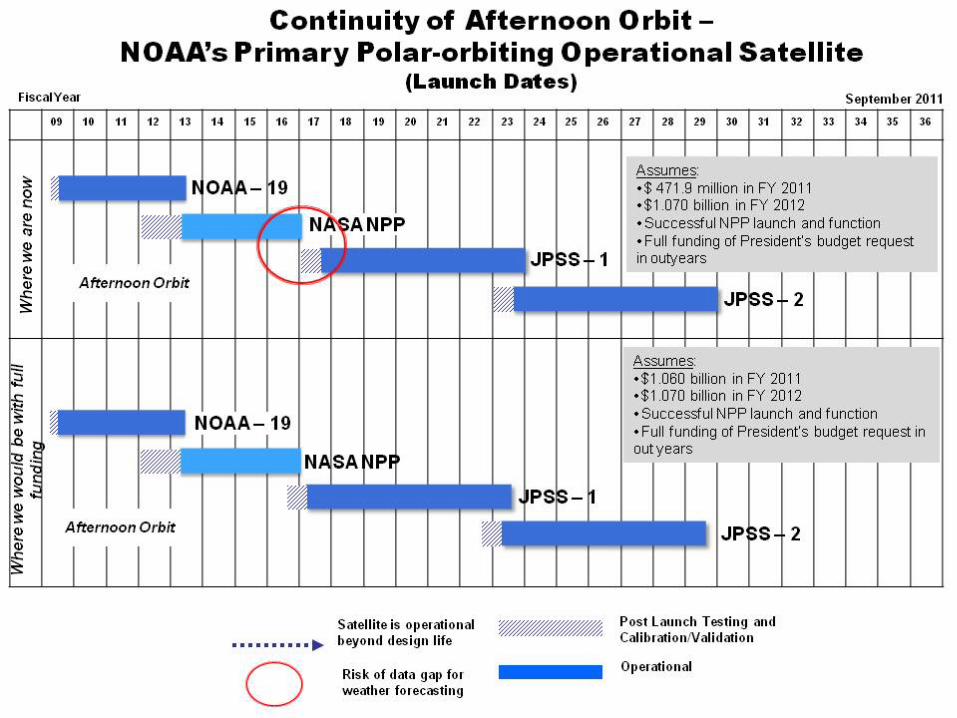
Status of the JPSS Program The FY 2011 Yearlong Continuing Resolution Appropriations Act did not provide the necessary increases over the FY 2010 enacted levels to support planned JPSS development. In response, the Department worked with NOAA and our Appropriations Committees to reallocate additional resources from within the Department to JPSS in FY 2011, however, the total funding available remains far less than required. This has significantly slowed progress of developing JPSS-1 and this funding situation leaves the JPSS Program vulnerable to cost, technical, and schedule challenges. Despite the lack of sufficient FY 2011 funding, NOAA and NASA professionals have made progress in JPSS program development. Status of the Space Segment – JPSS-1 Spacecraft In June 2010, NOAA directed NASA to contract with the developer of the NPP spacecraft bus to develop a near-duplicate of the NPP spacecraft bus as the JPSS-1 spacecraft bus. This decision was made to meet the planned 2014 launch of the JPSS-1 satellite, and minimize the chances of a gap in observations. However, due to lack of sufficient FY 2011 appropriated funds coupled with allocation of funds late in the fiscal year, the launch of JPSS-1 is now estimated to occur in the first quarter of FY 2017, resulting in near-certainty of a gap in observations after the end-of-life of NPP.
8
To operate with the available FY 2011 funding, NASA has had to slow work on the development of the JPSS-1 spacecraft bus to the minimum required to maintain contract viability. If the FY 2012 appropriations are not at the level of the President’s Budget and not appropriated by the end of the first quarter of FY 2012, additional launch delays in spacecraft bus development, and subsequently the JPSS-1 launch, will likely occur. Status of the Space Segment - Instruments The following instruments have been built, tested, and integrated onto the NASA NPP satellite for launch in October 2011: • Visible/Infrared Imager/Radiometer Suite (VIIRS) • Cross-track Infrared Sounder (CrIS) • Advanced Technology Microwave Sounder (ATMS) • Cloud and Earth Radiant Energy System (CERES) • Ozone Mapping and Profiler Suite (OMPS) Nadir, and OMPS-Limb These NPP instruments will provide more advanced data and capabilities than are currently available on the NOAA POES satellites. In some instances, NPP will provide new capabilities not currently available from NOAA POES. NOAA will continue to use the environmental data from NASA’s research and development Earth Observing System (EOS) Aqua and Terra satellites in its operational weather forecasting capabilities as long as these systems remain viable. The JPSS Program of Record as announced and budgeted for in the February 2010 decision will carry the instruments to meet the requirements as envisioned for the afternoon orbit of the NPOESS system including: VIIRS, CrIS, ATMS, OMPS-Nadir on JPSS-1, OMPS-Nadir and Limb on JPSS-2, TSIS, CERES, Advanced Data Collection System (A-DCS), Satellite-assisted Search and Rescue (SARSAT).3
Appendix B provides a summary of the measurements and applications from these instruments, and Appendix C provides the status of instrument development. Other data being leveraged include: • Microwave imaging data from the Japan Aerospace Exploration Agency (JAXA) Advanced
Microwave Scanning Radiometer (AMSR) instrument, which will fly on the JAXA Global Change Observation Mission (GCOM) missions. NOAA has completed negotiations with JAXA to acquire data from the first GCOM satellite (GCOM-W1) which is scheduled for launch in 2012. These measurements will partially fulfill requirements that would have been provided by the technically-challenging Microwave Imager Sounder previously planned for the NPOESS program.
3 For the JPSS-1 satellite, NOAA is exploring an alternate platform to carry the A-DCS, SARSAT, and TSIS instruments which will not fit on the JPSS-1 spacecraft bus. Currently, NOAA and NASA plan to conduct a full and open competition for the JPSS-2 spacecraft bus.
9
• NOAA will use data from DoD DWSS sensors as available. The Space Environment Monitor, expected to fly on the DoD DWSS satellite, is critical to meet the operational needs of the NOAA Space Weather Prediction Center.
Status of the Ground Segment The JPSS ground system consists of the antennas and support infrastructure that will: • communicate with NPP, and future polar orbiting satellites, JPSS and DWSS, • retrieve data from the satellites, • provide for the command and control center, • process data for use by the NWS and other operational users, and • support product quality assurance and long term data archive.
Due to the need to support NPP operations once it launches, NOAA applied a significant portion of its FY 2011 funds towards developing and fielding the ground system network in support of the October 2011 NPP launch. This will facilitate NOAA’s operational use of the NPP data for weather forecasting. The ground system built in preparation for NPP also serves as the precursor system for JPSS. When JPSS-1 launches in FY 2017, the time between gathering data on the satellite and delivering it to the National Weather Service will improve from approximately 120 minutes to 80 minutes. When JPSS-2 launches, our current plan is to reduce the latency further to approximately 30 minutes. NOAA and NASA have just successfully completed an end-to-end test of the ground system in advance of the NPP launch. The ground system currently deployed for NPP serves as the basis for the JPSS ground system. A series of improvements and updates are planned that will allow the ground system to support legacy satellites as well as JPSS, Defense Meteorological Satellite Program (DoD DMSP), Metop (EUMETSAT) and GCOM (JAXA) satellites. All of which will provide data to the Nation’s numerical weather models through the ground system. There may be a period of time when NOAA and DoD will operate legacy satellites that are ending their useful life, while at the same time operating the JPSS satellites. NOAA’s data processing systems will support ingest and data processing from these legacy systems (i.e., POES, DoD Defense Meteorological Satellite Program), and future systems – NPP and JPSS satellites. By having access to data from legacy and JPSS systems at the same time, NOAA will be able to support calibration and validation of the new NPP/JPSS data in a measured and deliberate manner. The period of overlap will allow NOAA to work with its users to allow for a smooth transition from the legacy to the future systems without affecting operational weather forecasting activities. Challenges: NOAA-identified Risks to JPSS Program Success Before I close, I would like to discuss some of the risks to JPSS program success that the NOAA-NASA technical and executive team has identified.
10
1. Lack of adequate, stable, and timely funding for the JPSS Program As discussed above, the lack of adequate, stable, and timely funding is a major impediment to JPSS program success. Despite the FY2011 situation, NOAA has worked to preserve the instrument suite in the February 2010 program of record and maintain the diverse set of observations and services at the expense of launch date delays. However, if the FY 2012 appropriations fall short of the President’s budget request, NOAA will need to reevaluate its core requirements and weigh those against any additional launch delays. These discussions and decisions will need to take into account the impacts of the diverse users of NOAA’s satellite data. Prior to the February 2010 restructuring of the NPOESS program, an independent review team concluded that the NPOESS program was inadequately funded and did not have the reserves necessary to address development challenges as they arose. The Administration presented budget requests in FY 2011 and FY 2012 that provided the funding required for a successful JPSS program, a program of known complexity. With the lack of appropriated funds, the JPSS program is rapidly reverting to the management posture of the NPOESS program in which programmatic decisions are based on available funds instead of meeting user requirements and achieving the scope and goals of the program. With current FY 2011 funding, NOAA is facing a near 100 percent chance of a data gap in the U.S. civilian polar orbit, on which both civilian and military users rely. This data gap would likely begin when the NPP satellite has reached the end of its projected life. 2. Risk of a gap in critical observations and impacts to users As the Nation’s polar-orbiting satellites near their end-of-life, NOAA is working with users to understand how to incorporate the next-generation observations and develop mitigation plans should a gap in observations become realized due to a failed NPP launch, early on-orbit failure of NPP, or continued delays to JPSS-1 and beyond. The risk of a gap is not only a concern, but also jeopardizes the very principle of NOAA as an operational agency. Because budget constraints resulted in a near-term focus of resources on NPP and JPSS-1, NOAA has been unable to define JPSS-2 and any subsequent satellites. Without satellites ready on the ground, ready for launch in the event of a launch or on-orbit failure, NOAA would no longer be able to consider this system operational in that the program would continually carry the significant risk of a gap in observations. NOAA is working with partner agencies, domestic and international, to determine what, if any, mitigation options are possible. These options include the potential use of data from foreign weather satellites; however, the potential use of data from foreign satellites would not mitigate the impacts of any loss in coverage of NOAA’s polar-orbiting satellites in the afternoon orbit. 3. Reduced credibility of the U.S. as a leader in world-wide meteorological satellite
data and services Many domestic and international organizations and agencies have come to rely on the U.S. to provide continuous coverage in the afternoon polar orbit. Emergency manager organizations in
11
the U.S. have the ability and infrastructure to receive timely, accurate weather forecasts and warnings to influence their decision-making. International weather agencies such as EUMETSAT have official agreements with NOAA to provide open access to each respective agency’s data. Should the U.S. suffer a gap in civil operational polar-orbiting satellite observations, there will be a ripple effect to multiple agencies and entities that depend on uninterrupted data from NOAA. This could have negative consequences in the long-term for the U.S. as we work toward the implementation of a global environmental observational network that leverages assets around the world and provides for increased cost efficiencies in space-based observations. Conclusion Providing operational earth and solar observations are imperative to helping protect life and property. NOAA is poised to continue and accelerate the activities in order to meet this mission and provide critically important observations, including through its core satellite programs and partnering with domestic and international entities. NOAA can achieve improvements in its forecast mission by strengthening four foundational pillars - improved satellite and in-situ observations; computing capacity; coupled atmosphere, ocean, land models, research and science advancements; and our people. NOAA believes that we can revolutionize the forecast process across the entire spectrum from relatively small-scale, short range applications to long-range weather and climate predictions. Although nothing can eliminate the physical threat that severe weather and natural hazards pose, NOAA has demonstrated success in better predicting these severe weather events, reducing their impact, and helping vulnerable communities become more resilient to their devastating effects – and will work to continuously improve its natural hazards products and services to the Nation. The foundation of these improvements is uninterrupted, continuous and sustained polar-orbiting satellite data that NPP and JPSS will provide. The advanced observational capabilities that the NPP satellite will demonstrate, and that are planned for the JPSS satellites, will provide significantly improved data that will benefit all users. This NPP and JPSS data will be vital inputs to forecast models, which provide the accurate forecast products critical to emergency managers’ preparations for severe weather events. We will also continue to evaluate polar-orbiting imagery wherever possible to support missions in data sparse areas. NPP will also continue critical global change measurements, which NASA initiated with its EOS, and further our understanding of climate and global change to enable informed decisions to mitigate and adapt to regional environmental changes. The largest risk to achieving success of the JPSS program of record remains the lack of adequate, stable, and timely funding. In conclusion, NOAA thanks the Committee for its continued interest and involvement in the success of NOAA’s satellite programs. I would be happy to answer any questions you may have.

Appendix B List of JPSS Instruments in the February 1, 2010 Program of Record
Instrument Function Contractor Source of Funding
Visible/Infrared Imager/Radiometer Suite (VIIRS)
Collects visible and infrared data to monitor atmospheric and surface environmental phenomena such as clouds, sea surface temperature, snow and ice
Raytheon El Segundo, CA
JPSS Program funds instrument development, integration onto spacecraft bus, and launch
Cross Track Infrared Sounder (CrIS)
Teams with ATMS to provide characterization of the Earth’s atmosphere (temperature, moisture, and pressure)
ITT Corporation (ITT) Fort Wayne, IN
JPSS Program funds instrument development, integration onto spacecraft bus, and launch
Advanced Technology Microwave Sounder (ATMS)
Teams with CrIS to provide characterization of the Earth’s atmosphere (temperature, moisture, and pressure)
Northrop Grumman Electronic Systems (NGES) Baltimore, MD
JPSS Program funds instrument development, integration onto spacecraft bus, and launch
Clouds and the Earth’s Radiation Energy System (CERES)
Provides data on incoming and outgoing radiant energy
Northrop Grumman Aerospace Systems (NGAS) El Segundo, CA
NOAA Climate Sensor Program funds instrument development. JPSS program funds integration onto spacecraft bus, and launch
Ozone Mapping and Profiler Suite (OMPS) Nadir and Limb
Provides data on amount of Ozone in the atmosphere, compliance with Montreal Accords
Ball Aerospace Boulder, CO
OMPS-Nadir instrument development, integration, and launch funded by JPSS Program
OMPS-Limb instrument development funded by NOAA Climate Sensor Program. JPSS program funds integration onto spacecraft bus, and launch
Total and Solar Spectral Irradiance Sensor (TSIS)
Provides data on the amount of energy emitted by the Sun
Laboratory for Atmospheric and Space Physics (LASP) Boulder, CO
TSIS instrument development funded by NOAA Climate Sensor Program. JPSS program funds integration onto spacecraft bus, and launch
Advanced Data Collection System (ADCS)
Monitors data from unmanned sites (buoys, etc.)
French Space Agency (CNES) France
CNES funds instrument development and provides it to NOAA. JPSS Program funds integration onto spacecraft bus, and launch
Search and Rescue Satellite-Aided Tracking (SARSAT)
Relays distress signals from mariners, aviators, and persons in distress
Canadian Department of Defence (DND) Canada
CNES and DND funds instrument development and provides it to NOAA. JPSS Program funds integration onto spacecraft bus, and launch

French Space Agency (CNES) France
Microwave imaging and sounding
Passive-microwave radiometer which measures precipitation rate, cloud water, water vapor, sea surface winds, sea surface temperature, ice, snow, and soil moisture.
To be procured by Japan Aerospace Exploration Agency (JAXA) Japan
JAXA funds instrument development, integration and launch. NOAA leverages data from JPSS program ground system.
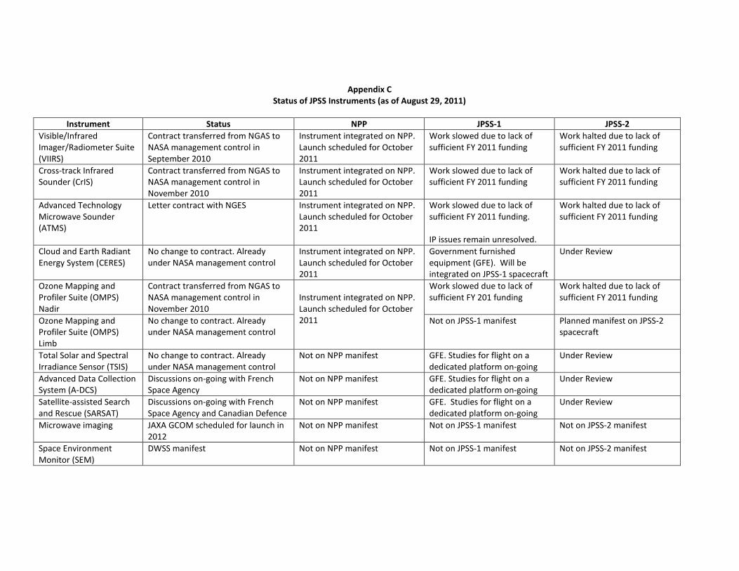
Appendix C Status of JPSS Instruments (as of August 29, 2011)
Instrument Status NPP JPSS-1 JPSS-2
Visible/Infrared Imager/Radiometer Suite (VIIRS)
Contract transferred from NGAS to NASA management control in September 2010
Instrument integrated on NPP. Launch scheduled for October 2011
Work slowed due to lack of sufficient FY 2011 funding
Work halted due to lack of sufficient FY 2011 funding
Cross-track Infrared Sounder (CrIS)
Contract transferred from NGAS to NASA management control in November 2010
Instrument integrated on NPP. Launch scheduled for October 2011
Work slowed due to lack of sufficient FY 2011 funding
Work halted due to lack of sufficient FY 2011 funding
Advanced Technology Microwave Sounder (ATMS)
Letter contract with NGES Instrument integrated on NPP. Launch scheduled for October 2011
Work slowed due to lack of sufficient FY 2011 funding. IP issues remain unresolved.
Work halted due to lack of sufficient FY 2011 funding
Cloud and Earth Radiant Energy System (CERES)
No change to contract. Already under NASA management control
Instrument integrated on NPP. Launch scheduled for October 2011
Government furnished equipment (GFE). Will be integrated on JPSS-1 spacecraft
Under Review
Ozone Mapping and Profiler Suite (OMPS) Nadir
Contract transferred from NGAS to NASA management control in November 2010
Instrument integrated on NPP. Launch scheduled for October 2011
Work slowed due to lack of sufficient FY 201 funding
Work halted due to lack of sufficient FY 2011 funding
Ozone Mapping and Profiler Suite (OMPS) Limb
No change to contract. Already under NASA management control
Not on JPSS-1 manifest Planned manifest on JPSS-2 spacecraft
Total Solar and Spectral Irradiance Sensor (TSIS)
No change to contract. Already under NASA management control
Not on NPP manifest GFE. Studies for flight on a dedicated platform on-going
Under Review
Advanced Data Collection System (A-DCS)
Discussions on-going with French Space Agency
Not on NPP manifest GFE. Studies for flight on a dedicated platform on-going
Under Review
Satellite-assisted Search and Rescue (SARSAT)
Discussions on-going with French Space Agency and Canadian Defence
Not on NPP manifest GFE. Studies for flight on a dedicated platform on-going
Under Review
Microwave imaging JAXA GCOM scheduled for launch in 2012
Not on NPP manifest Not on JPSS-1 manifest Not on JPSS-2 manifest
Space Environment Monitor (SEM)
DWSS manifest Not on NPP manifest Not on JPSS-1 manifest Not on JPSS-2 manifest