wotan’s throne just before sunrise - photograph …€™s throne just before sunrise ... place to...
TRANSCRIPT

Autumn color on the North Rim of the Grand Canyon is a great reason to visit Arizona in late September. Photographers are always looking for new ways to capture brilliant yellow foli-age on forests of quaking aspen found on high Southwest deserts. Panoramic Grand Canyon vistas can be photographed from new angles under a variety of lighting conditions. On the North Rim, you can find dramatic overlooks above spectacular displays of geology that are visited by very few people. On any given day, you may be the only person to visit that spot with a camera.
North Rim of theGrand Canyon
andKatherine’s
exploration ofGlacier Bay
National Parkin Southeastern
Alaska
Wot
an’s
Thro
ne ju
st b
efor
e su
nris
e
™
120October 2011
Where, when, and howto discover the best
photography in America
Published since 1989
The North Rim of the Grand Canyon is a thousand feet higher than the South Rim. Aspens grow above 7,500 feet and thrive on the North Rim. The North Rim’s entrance is two-hundred-and-twenty road miles north of the South Rim. Each year, the North Rim has less than ten percent of the number of visitors that flock to the South Rim. The North Rim’s visitor facilities are open from mid-May through mid-October. The road to the North Rim is closed by winter snow. If you are looking for a little solitude, some quiet photo explorations and plenty of autumn color, add the North Rim to your photo trip calendar.Eighty miles south of Kanab, Utah, and eighty miles west of Page, Arizona, State Highway 67, the only paved route to the North Rim, leaves Highway 89A at Jacobs Lake, Arizona, and stretches 45 miles south to the Grand Canyon at the end of the road. When you arrive at the North Rim, the Grand Canyon Lodge at Bright Angel Point blocks your view of the canyon.
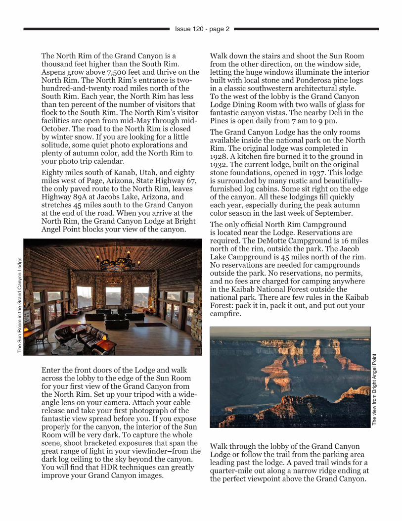
Enter the front doors of the Lodge and walk across the lobby to the edge of the Sun Room for your first view of the Grand Canyon from the North Rim. Set up your tripod with a wide-angle lens on your camera. Attach your cable release and take your first photograph of the fantastic view spread before you. If you expose properly for the canyon, the interior of the Sun Room will be very dark. To capture the whole scene, shoot bracketed exposures that span the great range of light in your viewfinder–from the dark log ceiling to the sky beyond the canyon. You will find that HDR techniques can greatly improve your Grand Canyon images.
Walk down the stairs and shoot the Sun Room from the other direction, on the window side, letting the huge windows illuminate the interior built with local stone and Ponderosa pine logs in a classic southwestern architectural style. To the west of the lobby is the Grand Canyon Lodge Dining Room with two walls of glass for fantastic canyon vistas. The nearby Deli in the Pines is open daily from 7 am to 9 pm.The Grand Canyon Lodge has the only rooms available inside the national park on the North Rim. The original lodge was completed in 1928. A kitchen fire burned it to the ground in 1932. The current lodge, built on the original stone foundations, opened in 1937. This lodge is surrounded by many rustic and beautifully-furnished log cabins. Some sit right on the edge of the canyon. All these lodgings fill quickly each year, especially during the peak autumn color season in the last week of September.The only official North Rim Campground is located near the Lodge. Reservations are required. The DeMotte Campground is 16 miles north of the rim, outside the park. The Jacob Lake Campground is 45 miles north of the rim. No reservations are needed for campgrounds outside the park. No reservations, no permits, and no fees are charged for camping anywhere in the Kaibab National Forest outside the national park. There are few rules in the Kaibab Forest: pack it in, pack it out, and put out your campfire.
Walk through the lobby of the Grand Canyon Lodge or follow the trail from the parking area leading past the lodge. A paved trail winds for a quarter-mile out along a narrow ridge ending at the perfect viewpoint above the Grand Canyon.
The
Sun
Roo
m in
the
Gra
nd C
anyo
n Lo
dge
The
view
from
Brig
ht A
ngel
Poi
nt
Issue 120 - page 2

The canyon is ten miles wide at this point, and the Colorado River is nine miles off in the distance. You can’t see the river from this spot. You will see many red stone spires, buttes, bluffs, and deeply fluted cliffs stretching off into the distance–all lit from the East at sunrise and from the West at sunset, the best times of day to arrive with your camera. From 9 AM to 5 PM, this entire view is backlit. It’s a struggle to cut through the blue haze and create a worthwhile photograph. Unless the sky over the canyon is filled with dramatic clouds, you may want to use normal to short telephoto lenses and crop off the horizon to eliminate washed-out skies in your photographs. Hard-edged graduated neutral density filters will darken a distant sky and retain highlights in distant clouds. The horizon line, above the distant South Rim, is straight and level. Set your lens at f22 and use your depth-of-field preview button while lining up any graduated filter with the horizon. For this trip, I used HDR techniques to avoid washed-out skies and enhance shadow details in backlit foregrounds.Plan a North Rim trip in late August or early September when clouds blow in from the Gulf of Mexico ahead of monsoon rains. This is when you’ll find dramatic skies for your infrared photography from Bright Angel Point.For my autumn color trip, I packed a cable release to shoot multiple bracketed exposures for HDR. Depending on the lighting range of my subjects, I shot three, five, or seven exposures of many subjects, bracketed in one-stop increments. When I don’t get the effect I want with HDR, I always have a good range of bracketed exposures to choose from later.Along the ridge trail to Bright Angel Point are several viewpoints above narrow side canyons dropping thousands of feet into Roaring Springs Canyon on the east side of the trail and into the canyon called The Transept on the west side of the trail. Do not climb over the railings.There are several overlooks directly below the Lodge that hang out over the abyss. Made of steel pipes bolted into holes drilled into the canyon walls and reached by metal stairways, these platforms offer photographers a solid place to set up a tripod and watch California condors soaring along the rim in the warm updrafts rising from the depths of the canyon.
A hidden observation room below the Sun Room offers photographers a clear view across the canyon on a rainy day. The trail that leads to the covered observation room continues along the canyon rim to the North Rim Campground. The Transept Trail winds along the rim through Ponderosa and spruce forest with openings for views of the canyon below. It’s a three-mile round trip hike from the Lodge to the campground and back.
After shooting a sunset and a sunrise from the Bright Angel Point Trail, you will be ready to start exploring the North Rim for more tripod locations. There are fewer choices here than on the South Rim.
North Kaibab TrailTwo miles north of the lodge is a parking area at the North Kaibab Trailhead. This is the only trail that will take you from the North Rim to the bottom of the canyon. It’s a 14-mile (one-way) hike and a 5,850-foot elevation drop, down to the Colorado River. From there, you have a choice of two trails to the top of the South Rim–the South Kaibab Trail to Yaki Point or the Bright Angel Trail to Grand Canyon Village.Most North Rim visitors bypass the North Kaibab Trail. If you want to experience a short hike down this trail, park in the trailhead lot or along the road nearby. Take your camera and a bottle of water. Walk a short distance down the trail and try to capture morning light through the forest along the trail. Read the cautions on the trailhead sign and walk only as far as you feel comfortable. It’s a steep hike back up. If a pack of mules and riders approach you on the trail, stop, step to the inside of the trail, and wait
Anot
her v
iew
from
Brig
ht A
ngel
Poi
nt
Issue 120 - page 3

for instructions from the wrangler. Mules have the right-of-way. They stir up dust that adds to the atmosphere of this trail. (below)
Mule rides into the canyon can be booked in the lobby of the Grand Canyon Lodge. None of the North Rim mule rides descend as far as the bottom of the canyon. The all-day ride turns around at Roaring Springs, near Bright Angel Creek. To reach Phantom Ranch by mule, sign up for a South Rim mule ride.
Widforss TrailThe Widforss Trailhead is a half-mile west of the pavement of Route 67. The marked turnoff is just north of the North Kaibab Trail and just south of the Cape Royal Road junction. There is a restroom at the trailhead parking lot and trail guides with a map are available in a box. This trail climbs to an overlook on the far side of The Transept, the canyon just west of Bright Angel Point. You can drive to Bright Angel Point, but you have to walk to Widforss Point (above).
It’s a five-mile hike each way. The view from the point is spectacular. It’s difficult to be out there at sunrise or sunset without hiking in or out in the dark. So I only walked halfway, along the rim trail for the best views down The Transept, a steep and narrow side canyon that drops into Bright Angel Canyon. In the distance to the south is a tall spire atop Oza Butte. Aspen, firs, and Ponderosa pines line the rim. Many twisted piñon pines grow up through cracks in the edge of the limestone on the rim. Their twisted shapes make great foregrounds for canyon compositions.At a point where the trail leaves the rim and cuts through the woods, down the middle of the ridge to Widforss Point, I turned around and headed back to the trailhead–a five-mile round trip hike that took me three hours.
Point SublimeThe road to the Widforss Trailhead continues westward to Point Sublime. One mile beyond the Widforss trail is a marked left turn onto a 17-mile rough and narrow dirt road that leads to Point Sublime, extending far out into the Grand Canyon on the west end of the North Rim. This overlook was named by geologist Clarence E. Dutton, who described the scene in 1881 as “by far the most sublime of all earthly spectacles.” Framed by Scorpion Ridge to the west and the tips of stone temples to the east, the Colorado River can be seen far in the distance. Be ready for the panoramic possibilities by shooting multiple vertical images with a telephoto to stitch together or by just relying on an extreme wide-angle lens.You may see no other people out there on Point Sublime because of the rough dirt road. The view makes the journey worth the effort. You will not want to drive to Point Sublime in the dark. If your plans include an overnight stay to photograph a sunrise and a sunset, you will need a backcountry camping permit (good for two nights). Stop at the Backcountry Information Center near the lodge to obtain a permit and to check on the condition of the road.Out on Point Sublime, you will be as far from the bright lights of civilization as you can go. On a clear, cloudless, moonless night, you can see the Milky Way and every other star standing out sharply and clearly. It’s a great spot for some astrophotography.
Issue 120 - page 4

The Cape Royal RoadThree miles north of the lodge at Bright Angel Point, a marked side road heads east toward Cape Royal. This paved road, a twenty-mile tour that can fill a whole day, follows the eastern rim of the Walhalla Plateau, a southeastern extension of the Kaibab Plateau.Five miles from Highway 67, the Point Imperial Road bears left and splits off from the Cape Royal road to follow Bright Angel Creek for about a mile to its source on the edge of the Kaibab Plateau. Here the creek begins a steep, six-thousand-foot drop down the massive Bright Angel Canyon to the Phantom Ranch on the Colorado River in the depths of the Grand Canyon. Steep hillsides above the stream were covered with bright yellow aspen during my recent visit the last week of September. Quaking aspen are the first large trees to grow after a forest fire. They create shade where ponderosa pines can grow and mature (below). Aspen at higher elevations seem to reach their peak color earlier than those along Highway 67.
At 8,803 feet, Point Imperial is the highest viewpoint inside the park on either side of the canyon–a great location for sunrise photography. Rim trails head north and south from Point Imperial. At this high elevation, start with short hikes to avoid overexertion.A short flight of stairs leads down from the east end of the parking lot to a small railed-in platform for panoramic views of the Vermillion Cliffs, visible to the north, and the Painted Desert to the east. The Little Colorado River Canyon lies to the southeast and Navajo Mountain lies to the northeast. Just below the viewpoint, Nankoweap Canyon descends eastward toward the Colorado River.
Arrive before the sun rises and you will have time to find the best viewpoint looking south. It includes the pointed spire of Mount Hayden rising in your composition’s foreground (below). The first few moments of morning sunlight illuminates the top of Mount Hayden and every other spire and ridgeline all the way to the South Rim. In case you miss the sunrise here, the west side of Mount Hayden lights up nicely in the evening. Good foregrounds will improve your photographs of the Grand Canyon. It’s not all grand vistas filled with distant spires, buttes, and mesas.
Drive back down to the junction and continue south on the Cape Royal Road to Roosevelt Point, the best overlook above Nankoweap Canyon. (below).
I like to arrive out on these overlooks before first light in the morning. I set my alarm clock to wake me extra early for some of the long drives out to photograph sunrises at distant
Issue 120 - page 5

overlooks. In October, you’ll need an ice scraper for your windshield. I drive slowly on winding mountain roads. Each morning on the North Rim I had to brake in the dark for deer, squirrels, and bobcats.I often eat breakfast while I’m waiting for the sun to rise. For these types of trips, I pack a bag of granola and a few of those small juice box/milk cartons that don’t require refrigeration. Lunch is usually trail mix and an orange. After photographing a sunset, it’s time to relax and enjoy a slow drive back to the lodge for dinner. Just after sunset, the local birds seem to enjoy sitting on warm pavement. I drive slowly and give them a chance to move out of the way.
Cape Final TrailA four-mile roundtrip hike leads to a breathtaking overlook above the Venus Temple and the Jupiter Temple (below). Too far to walk in the dark, the Cape Final overlook is a perfect location for a half-day photo session or an overnight wilderness camp-out.
Cape Final Trail climbs gradually from the trailhead parking lot on the east side of the paved road, through a pine forest. The first mile is a gradual climb eastward to the ridgeline and then it’s mostly downhill to the canyon rim where the trail bears south to pass several open viewpoints. A small sign points the way to the top of the rock pile on Cape Final. It’s a short scramble through broken limestone blocks to a spectacular viewpoint above a deep canyon where Unkar Creek flows toward the Colorado to form the Unkar Delta, just below the Desert View Tower on the South Rim. A long red ridgeline stretches north and south, far below
the cape. Dawn colors had faded, but I was able to capture the range of mid-morning light I saw by using HDR techniques.Near the overlook are several backcountry campsites (for which a permit is required) within a few feet of a several-thousand-foot drop. Sweet dreams campers.
Walhalla GladeAnother mile farther down the road, a short walk into the woods near the Walhalla Overlook will take you to the site of a pueblo where people lived nine hundred years ago. Original foundation stones (below) outline nine rooms that were used for living quarters and storage
rooms. Walls were stacked stones, and poles cut in the forest supported the roof. This site was a summer home for farmers who cultivated the Unkar Delta down on the river. Over 100 farm sites have been discovered on the Walhalla Peninsula. This area is lower and warmer than most of the North Rim, so winters here are milder. Farms on the Walhalla Plateau probably supplemented the limited number of small plots on the Colorado River below.My 10 mm wide-angle lens and bracketed exposures were just what I needed to capture the size and shape of the pueblo and control the range of light streaming through the trees and across the stones. A box at the trailhead is filled with guides to the history of the area.A short distance farther down the road is a wide turnout on the left with a great view of Angels Window. There are several good spots here for a vertical image, framing the full height of a weathered red limestone formation with a large opening near the top, the Angels Window.
Issue 120 - page 6

Cape Royal (7,865’)At the end of the Cape Royal Drive is a very large parking lot with two restrooms and two trailheads. Near the end of the paved road is the start of an easy, paved half-mile (round-trip) trail
leading out to the tip of Cape Royal, probably the highlight of the North Rim and my favorite sunrise and sunset location in this park.From several spots along the trail to Cape Royal, you can frame the distant Colorado River in Angels Window (above). Farther down the trail, you can walk out onto the flat top of the Angels Window (if you are not afraid of heights). In the distance, you can see the tall stone tower at Desert View on the South Rim.At the end of the trail is my favorite location for sunrise photography. I’ve taken a lot of photographs here and I’ve decided that my favorite tripod spot is just to the right of the large visitor’s sign describing what they are looking at. A 20 mm lens at that location fills my viewfinder with a horizontal composition including the full length of the formation called Wotan’s Throne (below).
From this spot, morning light illuminates the sheer vertical wall at the near end, the eastern end of the Throne and includes a large, well-shaped juniper in the near corner of the frame.A few photographers can usually be found here later in the day at sunset. I prefer a different tripod spot for shooting sunsets at a nearby spot called the Wedding Site. Back at the far end of the large parking area at Cape Royal is another marked trailhead leading to a picnic area near the rim. In the picnic area is a sign pointing to the Wedding Site. From this spot is an excellent panoramic view of the entire north side of the formation called Wotan’s Throne, one of the most recognizable freestanding formations in the Grand Canyon (below).
If you shoot from this viewpoint, pick the best spot for your tripod well before sunset. I pack a paperback mystery novel in my camera bag to read while waiting for the best light. As the sun dropped in the west, the light got better and better, and more photographers arrived. There are only a few good clear openings along this stretch of the rim. Arrive early to claim your spot. At the end of a hot summer day, dusty haze on the western horizon can turn very red, giving you the perfect light for this image. I wait at least 15 minutes after a sunset in case there is some alpenglow to capture.
Kaibab National ForestArizona State Highway 67 passes some grand meadows along the road to the North Rim of the Grand Canyon. Many are lined with quaking aspen groves. They are usually painted a bright yellow during the last week of September. A few aspen groves are within walking distance of the road. A telephoto is useful for the others. If you are looking for large aspen groves that are easily
Issue 120 - page 7

accessible, drive the Kaibab National Forest roads to the north of the park boundary to find hundreds of miles of well-graded, unpaved logging roads called Forest Development Roads or FDRs. They are not shown on the free maps given visitors at the Park entry point. Kaibab Forest road maps are available at the Visitor Center near the Lodge and at the North Rim General Store on Route 67.
Drive some of these FDR roads and you will find beautiful campsites in aspen groves along streams and near the canyon rim. Backpack in and set up a tent or drive your motor home a few miles off the pavement of Route 67 and you’ll find many places to camp. Kaibab National Forest campsites are free and no permits are required.Few visitors to the North Rim discover the remote canyon viewpoints along the rim located just outside the national park boundary. Some of these spots are spectacular. You’ll need a good map to find them. Pick up a Kaibab National Forest road map at the North Rim General Store (across the road from the Kaibab Lodge). Drive one mile south and turn east at the junction of Highway 67 and Forest Road 610. This well-graded gravel road will take you to five overlooks above the Saddle Mountain Wilderness for panoramic views of the wandering route of the Colorado River. Drive one mile and continue straight through the first junction following Forest Road 611, marked on the road signs, to the East Rim Viewpoint where a paved trail leads a half-mile to a view, across North Canyon, of a long ridge far below the rim called the Cocks Comb. From this viewpoint, you look directly into the rising sun. If you are
staying at the Kaibab Lodge, this is the closest sunrise spot with less than a 15-minute drive. If you plan to camp, find your spot in the woods as close to the overlook as you like.My favorite sunrise location outside the park is at Marble Overlook, just across North Canyon. Drive thirty minutes back down FDR Road 611, and then south on 610 to 219, which heads north again, through five miles of aspen forest, to the end of the road (left). Park anywhere in the trees, along the edge of the forest, and your view is across acres and acres of open meadow that rolls over the edge like an infinity pool. Orange lichen patterns cover most of the rocks on this meadow.Far below Marble Overlook is a different view of the Cocks Comb and North Canyon. This overlook faces north at an elevation of 8900 feet. These viewpoints are outside the national park where there are few rules. Just put out your campfires! There are no safety rails on the edge of these overlooks. You may be the only person at any of these overlooks and you probably won’t see more than a few cars on the roads.Rustic cabins and a good restaurant are available at Kaibab Lodge, six miles north of the park entrance. Across the road are the North Rim General Store and a gas station. Jacobs Lake has all these same services. It’s forty-five miles north of the park entrance.
West Side RoadTwo miles south of Kaibab Lodge is a junction on Route 67 where FDR 22 heads west. This is called the West Side Road, a wide and smooth, well graded gravel road that heads northwest almost in a straight line toward Fredonia, Arizona. The last 15 miles are paved before reaching Highway 89A. Heading off this road are many numbered side roads heading to viewpoints on the North Rim that are located outside the Grand Canyon National Park. A dozen of these overlooks are marked on the Kaibab Forest road map. If you leave the paved roads, you need a good map. Many of the unpaved roads in this area are rough, steep, and require good ground clearance and sometimes four-wheel-drive. Without a good map, you could get lost out there. The Kaibab Forest road map describes the condition of each road with thin lines, thick lines, and dotted lines in various colors.
Issue 120 - page 8

Crazy Jug OverlookI drove 24 miles northwest on FDR 22, also called the West Side Road, to the marked junction with FDR 427. I turned and drove south for another 12 miles to the edge of the North Rim at a spot called Crazy Jug, a location recommended by a park ranger.I had to slow for some potholes and washboard stretches in the graded gravel road. I just followed the well-marked road signs pointing the way at several junctions. There is an easy turn around area near the overlook at the end of the road and a short trail down to an overlook a thousand feet above an immense circular valley called Tapeats Amphitheater. At the end of the trail is an overlook just above the Crazy Jug, a tall white stone circular tower with a bowl in the top. Move a bit closer to the edge and you can frame it with the twisted remains of two dead piñon pines. This is a good late afternoon location. It’s a long drive back to the North Rim lodges in the dark.The drive out to the Crazy Jug Overlook took a half-day. There were no other visitors at the overlook and very few tire tracks on that late October afternoon. I enjoyed a cool breeze and solitude on the overlook.If North Rim lighting conditions are perfect and spectacular images spread out in all directions, consider shooting multiple exposures to stitch together later into panoramic images. My Acratech ball head can be used in an inverted position for shooting panoramic images. Instead of leveling a tripod by adjusting the legs, you can use the Acratech ball head’s built-in bubble to quickly level just the head.
This keeps your 180˚ panoramic exposures level with the horizon. To mark my panoramic exposures to be easily found later during my editing sessions, I shoot my left hand in the frame before the first exposure and my right hand in the frame after my last exposure.When you enter the national park at the North Rim, you will be given a free map of the area. If you plan to hike some North Rim trails, you need a better map with the names of peaks, mesas, and canyons. To caption your photographs when you get home, buy a copy of the Trails Illustrated map by National Geographic. If you will be driving national forest roads to overlooks outside the boundaries of the national park, you need a copy of the Forest Service map of the Kaibab National Forest. These maps are sold at the Visitor Center near the Lodge and at the North Rim General Store on Highway 67. No services are available beyond the paved roads on the North Rim or in the Kaibab National Forest.To discover another dramatic North Rim overlook on a remote downstream section of the Colorado River, add a side trip to Toroweap on the North Rim, a favorite of landscape photographers but rarely visited by tourists. Early morning light is best for photographing at Toroweap Overlook, located in an isolated region of northwestern Arizona along the North Rim of the Grand Canyon. For detailed directions to Toroweap, see newsletter #61, page 5. Do not drive the unpaved road to Toroweap in the dark. Come prepared to sleep in your car or stay in one of the nearby campsites beneath large, overhanging sandstone ledges. You need a four-wheel-drive vehicle for a trip to Toroweap.
Issue 120 - page 9

When researching and photographing new locations for newsletters, it works best for me to travel alone. Katherine usually stays home to take care of business. Recently, Katherine got a chance to take her first trip to Alaska. She signed up for an Inside Passage and Glacier Bay cruise, borrowed my camera and laptop, and set off to write her own Photograph America Newsletter article.
Here is Katherine’s report:
With Bob’s tight travel schedule and with my own interest in Alaska and Glacier Bay, I researched the possibilities of exploring Alaska’s Inside Passage and Glacier Bay and of writing an article for Photograph America Newsletter. Glacier Bay is one of Alaska’s most spectacular attractions and is accessible only
by boat or plane. A number of cruise lines, such as Princess Cruises, Holland America, and Norwegian, tour Alaska’s Inside Passage and include Glacier Bay in their itineraries.I wanted to experience boarding the ship in San Francisco and sailing out through the Golden
Gate, so I arranged passage on the Sea Princess of the Princess Cruise Line, the only cruise line that embarks from San Francisco. A cruise of the Inside Passage of Alaska offers photographic discoveries of landscapes and wildlife that can be extraordinary, particularly in Glacier Bay National Park and Preserve. The crew of the Inside Passage cruise was committed to maximizing the landscape and wildlife photo opportunities for passengers who are photographers. It was easy to avoid all the diversions, entertainments or group events
that were not my cup of tea. As a photographer, exploring and photographing from a cruise ship may not be your favorite way of traveling.There are many excursions available at each port. Flights, bus tours, kayak tours, and up-close glacier explorations by small boats can be reserved in advance.In 1879, John Muir traveled to Glacier Bay in hopes of proving his theory that Yosemite Valley had been formed from glacier activity. In 1980, Glacier Bay National Park and Preserve was created by an act of Congress. The spectacular landscape and waterway of Glacier Bay is 50 air miles west of Juneau, Alaska’s state capital, and is explored and photographed by scheduled ferry, by tour boat service, by cruise ship, or by charter services.Air connections can be made to Glacier Bay from Juneau, Skagway, or Haines. Alaska Airlines provides regular jet service from Juneau to the town of Gustavus, near the mouth of Glacier Bay. The town of Gustavus has a grocery store and gift shop, a gas station and taxi service. A ten-mile road, the only land route to Glacier Bay National Park, connects Gustavus to the park ranger station at Bartlett Cove.
Glacier BayNationalPark andPreserve,Alaska
Sea
Prin
cess
leav
ing
San
Fran
cisc
o Ba
y
Gla
cier
Bay
, Ala
ska
Issue 120 - page 10

For other options than a cruise, fly into Juneau and use the ferry, an airline or one of the tour boat services to reach the town of Gustavus, where you can find a good choice of lodgings. Make your lodging reservations at Glacier Bay Park Lodge near the Bartlett Cove docks or at one of the hotels in the town of Gustavus.
The Alaska Marine Highway Service (the ferry) offers twice-weekly summer service from Juneau to Gustavus. The ferry service has no cabins with sleeping quarters. Riders can pitch a tent or spread out sleeping bags on the deck. Arrive with your own vehicle on the ferry or rent a car to drive the ten miles to the park. Glacier Bay Lodge, the only accommodations inside the park, offers 56 rooms, all with private bath and/or shower. Also located at the lodge are a restaurant and a National Park Service Visitor Center. The lodge is open from mid-May to mid-September. There are 16 full-service inns and lodges in and around Gustavus, ranging from basic rental cabins to luxury fishing lodges.Glacier Bay National Park and Preserve protects over three million acres of forest, thousand-foot-deep fjords, inlets and shoreline, surrounded by snow-capped mountain peaks and nine tidewater glaciers. Small tour boats can get you close enough to see small showers of ice and snow tumbling into the bay–signaling that calving is about to happen. Morning and afternoon light brings out the deep textures of the ice flows and warms up the color of the sky, contrasting with the deep blue colors of the 300-foot walls of slowly moving ice.Cruise ships provide an all-day tour of Glacier Bay, typically starting from the west and traveling in a clockwise direction. My
cabin was on the port side of the ship, which provided some of the best views. When I wasn’t photographing glaciers from the deck or my cabin, I was watching for spray from humpbacks. I used a 24-120 mm zoom lens to frame the wide scenes and capture close-up details of breaching humpbacks. Park naturalists on the cruise ship pointed out mountain goats on steep cliffs, and brown bears, the grizzly, can be spotted along the shore of Glacier Bay. Moose are often seen around Gustavus, Bartlett Cove, and the lower bay.Smaller, concessionaire-operated tour boats depart daily during summer months from Glacier Bay National Park in Bartlett Cove and offer tours for whale watching, photography, and wildlife viewing. These seven-hour tours explore 130 miles through Glacier Bay. Naturalists from the Park visitor center are on board with running commentary on geology, history, and wildlife.
Everyone on board was on the lookout for orcas and whales. I saw small porpoise, and larger Dall’s Porpoise in black and white, looking somewhat like killer whales. Minke Whales, a smaller, baleen whale are the same size but do not produce a visible spout and do not raise their tails when they dive, like the humpbacks.Humpback Whales are most often sighted near the entrance to Glacier Bay. Water vapor hanging in the air is an indicator that a whale is about to surface. Sea lions can be seen clustered tightly on the rocky shorelines of small islands in Glacier Bay. Tufted and horned puffins nest here alongside cormorants and kittiwakes. Bald eagles can be spotted at any time. A few eagles were perched on floating ice, near salmon spawning streams.
Mar
gerie
Gla
cier
at t
he n
orth
end
of G
laci
er B
ay
orca
on
Gla
cier
Bay
Issue 120 - page 11

Glacier Bay photography explorations by small tour boat travel parallel to the shore, usually counter-clockwise from the Visitor Center at Bartlett Cove. Wildlife activity can be spotted along the shoreline and out on the bay. Reid Inlet, near the far end, on the west side of the bay, has the most seal activity. The day I was there, Reid Glacier was actively calving with accompanying loud booming sounds.The most photographed glaciers here are Margerie and the Grand Pacific Glacier, at the far northern end of Glacier Bay. I was pleased with my photograph of Margerie Glacier, taken during the middle of the day under cloudy and drizzly conditions.Along the Inside Passage of Alaska, the Sea Princess stopped at Juneau, Skagway, Ketchican and Victoria, British Columbia. A good selection of shore excursions was available at all of these ports.I toured the Mendenhall Glacier from Juneau, Misty Fjords from Ketchikan, and, when the ship docked in Victoria, B.C., the Butchart Gardens. We cruised back under the Golden Gate Bridge to San Francisco where I disembarked to find Bob for my ride home.
head
ing
hom
e un
der t
he G
olde
n G
ate
In K
etch
ikan
Har
bor
Have a great trip and send us an email.
My life-long career in photography began at San Jose State University in 1957. After college, I enlisted in the U.S. Army Signal Corps, serving as a photographer and darkroom technician. In Germany, my skills and expe-rience with equipment and lab work were developed and polished. I took the opportunity to photograph the beauty of nature in the Black Forest. Returning to California in 1965, I produced industrial and military training films for Raytheon Electronics and began showing my color nature prints. From 1969 through 1981, my photography was exhibited and sold in West Coast galleries. During the early 1980’s, I taught color darkroom workshops, then expanded to include field trips. Former customers, who had purchased my framed photographs, wanted to learn photography. My Pacific Image Photography Workshops offered adventures to the Pacific Coast, the Southwest deserts, national parks, Hawaii, New England, Canada, En-gland, and the South Pacific. The workshops evolved into writing and sharing my adventures with others. Photograph America Newsletter provides information on where, when, and how to discover the best nature photography in North America.
Photograph America Newsletteris published quarterly (four issues/year)by Robert Hitchmanassisted by technical associate/wife, KatherinePost Office Box 86, Novato, CA 94948-00861-415-898-9677
www.photographamerica.com
All contents of this newslettercopyright © 1989-2016 Robert Hitchman
Please don’t make copies for your friends.This is a violation of Federal copyright laws.This newsletter survives on subscriptions.