workshop proceedings - graham sustainability...
TRANSCRIPT
Great Lakes
SWAT Modeling
WorkshopMarch 18-19, 2014
University of Michigan
Joseph DePinto, LimnoTech
Margaret Kalcic, U-M Water Center
Rapporteurs
WORKSHOP PROCEEDINGS
2
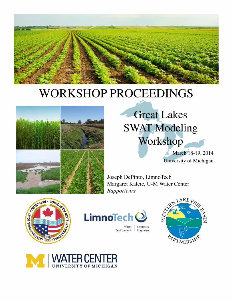
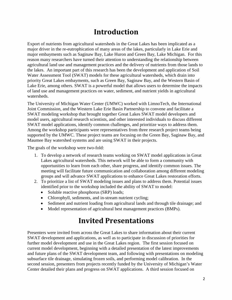
Introduction Export of nutrients from agricultural watersheds in the Great Lakes has been implicated as a major driver in the re-eutrophication of many areas of the lakes, particularly in Lake Erie and major embayments such as Saginaw Bay, Lake Huron and Green Bay, Lake Michigan. For this reason many researchers have turned their attention to understanding the relationship between agricultural land use and management practices and the delivery of nutrients from those lands to the lakes. An important part of this research has been the development and application of Soil Water Assessment Tool (SWAT) models for these agricultural watersheds, which drain into priority Great Lakes embayments, such as Green Bay, Saginaw Bay, and the Western Basin of Lake Erie, among others. SWAT is a powerful model that allows users to determine the impacts of land use and management practices on water, sediment, and nutrient yields in agricultural watersheds.
The University of Michigan Water Center (UMWC) worked with LimnoTech, the International Joint Commission, and the Western Lake Erie Basin Partnership to convene and facilitate a SWAT modeling workshop that brought together Great Lakes SWAT model developers and model users, agricultural research scientists, and other interested individuals to discuss different SWAT model applications, identify common challenges, and prioritize ways to address them. Among the workshop participants were representatives from three research project teams being supported by the UMWC. These project teams are focusing on the Green Bay, Saginaw Bay, and Maumee Bay watershed systems and are using SWAT in their projects.
The goals of the workshop were two-fold:
1. To develop a network of research teams working on SWAT model applications in Great Lakes agricultural watersheds. This network will be able to form a community with opportunities to learn from each other, share progress, and identify common issues. The meeting will facilitate future communication and collaboration among different modeling groups and will advance SWAT applications to enhance Great Lakes restoration efforts.
2. To prioritize a list of SWAT modeling issues and plans to address them. Potential issues identified prior to the workshop included the ability of SWAT to model: • Soluble reactive phosphorus (SRP) loads; • Chlorophyll, sediments, and in-stream nutrient cycling; • Sediment and nutrient loading from agricultural lands and through tile drainage; and • Model representation of agricultural best management practices (BMPs).
Invited Presentations Presenters were invited from across the Great Lakes to share information about their current SWAT development and applications, as well as to participate in discussion of priorities for further model development and use in the Great Lakes region. The first session focused on current model development, beginning with a detailed presentation of the latest improvements and future plans of the SWAT development team, and following with presentations on modeling subsurface tile drainage, simulating frozen soils, and performing model calibration. In the second session, presenters from projects recently funded by the University of Michigan’s Water Center detailed their plans and progress on SWAT applications. A third session focused on
3
further applications of SWAT and included a focus on the challenges of linking models as well as agricultural BMPs. Afterward, common issues and challenges were discussed in preparation for the breakout sessions that followed.
SWAT Model Use and Development
CURRENT STATE OF SWAT AND FUTURE DEVELOPMENTS
Jeff Arnold, USDA-Agricultural Research Service
Jeff Arnold, well known for his original role in development of the SWAT model (Arnold et al., 1998) and his continued leadership in its ongoing development, provided an overview of the latest model development and conveyed a vision of future SWAT tools and collaborations. Recent model improvements included more realistic sediment transport through stream channels, more advanced treatment of soil phosphorus, nitrate and soluble phosphorus transport through tile drainage and surface inlet risers, and the addition of perennial crops and plant competition. These improvements in prediction of nutrient leaching through tile drainage came in part from researchers working in the Great Lakes, and will be particularly relevant to ongoing efforts to predict the effect of land management on soluble phosphorus loading. Arnold also highlighted a number of tools that aid in model setup, use, and calibration, and emphasized the importance of using “soft” data to judge model performance alongside “hard” data traditionally used in model calibration.
Model components currently under development included a landscape routing approach for hydrologic linkage of hill-slopes and valleys, version control for improving efficiency and parallelization of the model, and a new modular structure that aids in code development and maintenance. Within this new module structure the developers have created three versions of SWAT with varying levels of complexity and corresponding computational efficiency, which he referred to as a “three tiered approach.” “SWAT HRU” is what SWAT users are familiar with, while “SWAT Lite” has simplified water, nutrient, and sediment balance, as well as simplified management operations, and “Export Coefficient / Delivery Ratio” produces existing data and model outputs.
Arnold’s vision for the near future centered on increasing the widespread usability of SWAT through web-based decision support tools. The Hydrologic and Water Quality System (HAWQS) project under development is a web-based SWAT model of national scale that will include two possible scales of analysis: the fine-scale National Hydrography Dataset Plus (NHD Plus) stream network for use with SWAT-Lite, and a setup with predefined watersheds at the 12-digit hydrologic unit code (HUC) scale with the full SWAT model. Progress is underway for models with NHD Plus to 12- and 8-digit HUC subwatersheds for Upper Mississippi River Basin. Arnold’s vision for collaboration in the Great Lakes is for a common Great Lakes Decision Support System using the three tiered approach now included in the modular version of SWAT.
4
TILE DRAINAGE IN SWAT
Jane Frankenberger, Purdue University
Jane Frankenberger shared her insights on the latest development in SWAT’s subsurface tile drainage routine and its prediction of drain flow and nitrate loading in intensively tile-drained croplands. She presented measured data on surface and drain flow hydrographs, showing that timing of drain flow behaves more like surface flow than baseflow. She explained the tile drainage routine in SWAT 2012 in depth, which is somewhat based on DRAINMOD drainage routines. She commented on many model parameters, suggesting that SCS curve number may be reduced to simulate greater infiltration common in tile-drained soils and that roughness of the soil surface should be used as a user-defined parameter. One challenge she highlighted was the depth to impermeable layer dictating the permeability of that layer, and suggested the parameter be split into two parameters. Another challenge was simulating flow and phosphorus loading to tiles through macropores. Her remarks on tile drainage concluded with presentation of the fairly new best management practice (BMP) “drainage water management.”
The remainder of the presentation focused on simulating BMPs in the Upper Maumee Watershed to inform watershed management planning in that region. They incorporated data for point source discharges, as well as the presence of existing BMPs (data obtained through NRCS and not publicly available) in their model configuration. One interesting finding was that no-tillage, while commonly implemented in the watershed, had little influence on nutrient and sediment loading in the watershed. On the other hand, conservation cover had high effectiveness but limited implementation. This is one situation where using a model to estimate watershed-scale effectiveness of BMPs may help in prioritization of future BMP implementation.
DEVELOPMENT OF A CANADIAN VERSION OF SWAT TO EXAMINE WATER QUANTITY AND QUALITY
EFFECTS OF AGRICULTURAL BMPS
Wanhong Yang, University of Guelph
Wanhong Yang presented on a number of model improvements and applications related to snow and frozen soil algorithms, BMPs, and integration of SWAT with economic modeling. Model development has taken place in a Canadian version of SWAT (CanSWAT) and is not yet available in the SWAT model. To more realistically simulate snowpack in northern climates, Yang’s group has added a snow redistribution module controlled by climate, topography, and land cover. They also improved simulation of soil erosion and nutrient runoff during thawing conditions, and evaluated the CanSWAT model on a heavily-monitored watershed. Yang then explained the need for calibrating parameters related to runoff, soil erosion, and nutrients, to simulate conventional and conservation tillage under frozen soil conditions. He also shared details on an interface that integrates hydrologic and economic models. Last, he presented simulations of existing and proposed Water and Sediment Control Basins (WASCoBs) in a SWAT configuration of the Gully Creek Watershed in Ontario, which drains to Lake Huron.
5
SWAT CALIBRATION: WHAT ARE WE MISSING?
Rem Confesor, Heidelberg University
Rem Confesor presented results from a simultaneous multi-objective auto-calibration approach for a SWAT configuration of the Sandusky watershed draining to the Central Lake Erie basin. Calibration occurred at a gaging station where daily flows and concentrations of nutrients and sediments have been measured for the period 2003-2011. Comparison of two models, one with 719 hydrologic response units (HRUs) and the other with 4350 HRUs, showed that each model was most sensitive to different parameters. He ranked each parameter according to model sensitivity for flow, sediment, total phosphorus, soluble reactive phosphorus (SRP), and nitrate, and created an average ranking for each parameter. Confesor performed optimization in the programming language R, using the non-dominated sorted genetic algorithm (NSGA-II) to minimize the Root Mean Squared Error of flow, sediment, and nutrients in a Linux-based parallel computing environment. He tested the outcome of this multi-objective optimization against a conventional, single-objective optimization, which follows the order of calibrating for flow, sediment, and finally nutrients. A notable finding was that in some cases suitable calibration to measured streamflow can prohibit successful calibration to nutrients or sediments. He combined this ensemble of calibrations to estimate uncertainty of model predictions of sediment and SRP loading from BMP scenarios for different tillage and fertilizer application methods.
Applications in Water Center-Supported Research
DEVELOPMENT AND APPLICATION OF SWAT MODELS TO SUPPORT THE SAGINAW BAY OPTIMIZATION
DECISION MODEL
Joe DePinto, LimnoTech
Joe DePinto presented the project plan and progress to date for the Saginaw Bay Optimization Decision Model (ODM) UMWC funded project being led by Saginaw Valley State University , which is “a suite of data, models and decision tools that help set realistic goals and support strategic conservation decisions for farmers, based on ecological benefits in watershed rivers and near-shore ecosystems.” The ODM will consider river and near-shore ecosystems, algal and fish communities, and socioeconomic factors such as crop yields and beach closures. Through stakeholder workshops the team will also develop an idealized ODM, which cannot be realized given available time and resources and data, but may be used to prioritize future data collection and modeling efforts. The realized ODM will be tested in three primarily agricultural watersheds, the Kawkawlin, Pigeon, and Pinnebog, which drain directly to Saginaw Bay of Lake Huron. A linked model framework will include fine-scale SWAT models for the three watersheds that simulate nutrient and sediment loading, which drives a Saginaw Bay linked hydrodynamic-nutrient-lower food web model (SAGEM2) and an assessment of in-stream fish communities. Outcomes include evaluation of existing agricultural management and spatial optimization of potential BMPs.
6
DePinto also summarized LimnoTech’s SWAT work in the Tiffin River watershed, which is a part of the Maumee watershed draining to Lake Erie. They have added a new routine for ephemeral gully erosion to SWAT (LimnoTech, 2013), and determined that these gullies can contribute to a large proportion of soil erosion and associated phosphorus export from some HRUs. They also targeted placement of several BMPs for total phosphorus reduction at the watershed outlet. DePinto identified a number of SWAT challenges, including transport of SRP through tile drains and unrealistic in-stream phosphorus cycling from phytoplankton growth.
DEVELOPMENT AND APPLICATION OF SWAT MODELS IN THE FOX-WOLF BASIN OF GREEN BAY
Paul Baumgart, University of Wisconsin-Green Bay
Paul Baumgart presented the project plan for the Fox-Wolf Basin, which drains to Lake Michigan’s Green Bay. The project aims to expand the Total Maximum Daily Load (TMDL) approach for nutrient and sediment loading to Green Bay, to assess the impacts of BMPs and climate change in the watershed, and to engage resource managers to improve and better defend mitigation strategies. Baumgart showed the calibration and validation of the SWAT configuration for the Lower Fox River, whose watershed has 50% agricultural land managed for dairy production and requires major phosphorus and sediment reductions. To better validate the model, five monitoring stations with continuous flow and daily sediment and phosphorus loads were added to the watershed for 2004-2008. They used this calibrated configuration to test agricultural BMP scenarios, including conservation tillage, phosphorus fertilizer management, filter strips, rotational grazing, cover cropping, incorporation of manure, and conversation to perennial switchgrass.
Baumgart then shared work on the Upper Fox and Wolf River sub-basins, which utilized a SWAT model with many unique modifications to its source code: the SCS Curve Number (CN) was dynamically dependent on soil hydrologic group and tillage operations; division of the Residue C-factor for biomass into above-ground living biomass and remaining crop residues so that no-tillage would continue to provide soil erosion benefits over conventional tillage in the growing season; and a number of further modifications to the Modified Universal Soil Loss Equation (MUSLE). He also commented on the uniform soil particle size distribution from agricultural land, which may influence sediment routing through reservoirs, and he called for possible research and model development in this area.
WATERSHED-SCALE ASSESSMENT OF STACKED DRAINAGE PRACTICES IN THE WESTERN LAKE ERIE
BASIN TO IMPROVE WATER QUALITY
Scott Sowa, The Nature Conservancy Matt Herbert, The Nature Conservancy Sheila Christopher, University of Notre Dame Jeff Arnold, USDA-Agricultural Research Service
Four members of this team presented on the goals, preliminary work, and future plans for implementing drainage water management and two-stage ditches in SWAT and evaluating their impact on water quality. The project utilizes an existing SWAT configuration created for the Western Lake Erie Basin (WLEB) Conservation Effects Assessment Project (CEAP). They provided an overview of the WLEB CEAP SWAT modeling efforts, including linking SWAT
7
outputs to biological endpoints through downscaling to the NHD Plus level and development of online decision tools for tracking and targeting BMPs. They showed the influence of “regional calibration” on model effectiveness, in which they calibrated the model at multiple gaging stations in the basin.
They provided an overview of project tasks that require building conceptual models of two-stage ditch and drainage water management and generating algorithms for implementation in SWAT. The conceptual model of the two-stage ditch included ditch geometry, nitrogen and phosphorus uptake rates, and duration of flooding, with outcomes measured by streamflow and nutrient and sediment loading. Measured two-stage ditch data support a positive correlation between in-stream nitrate and denitrification rates, while such a relationship for in-stream phosphorus reduction is less established; and so they anticipate using turbidity reduction rates to calculate total phosphorus and soluble reactive phosphorous uptake. The conceptual framework for drainage water management involved geometry of tile drains and the timing of opening and closing tiles, with an expectation that these systems may impact streamflow, nutrient loading, and crop yields. Using SWAT to estimate water quality benefits of innovative BMPs and working with the WLEB CEAP Large Advisory Panel increase the exposure of this work and may lead to adoption of these practices.
Further Great Lakes SWAT Applications
SWAT MODELING FOR NUTRIENT LOADING UNDER BMP AND CLIMATE SCENARIOS IN LAKE ERIE
WATERSHEDS
Nate Bosch, Grace College Margaret Kalcic, University of Michigan Water Center
Nate Bosch summarized the approach and results from an ecological forecasting project where models were used to forecast Lake Erie hypoxia under future land use and climate. Calibration and validation of six Lake Erie watersheds using SWAT 2005 revealed difficulties in simulating urbanized watersheds and the importance of measured data frequency and duration. BMP scenarios for random placement of filter strips, cover crops, and continuous no-tillage of corn and soybeans revealed that implementation at “feasible” rates provided minimal improvement in phosphorus loading to Lake Erie. When combined with future climate scenarios, in which winter and summer temperatures shifted by 2-7°C and spring and fall precipitation shifted by -7 to 29%, even greater BMP implementation may be needed to improve phosphorus loading.
Margaret Kalcic presented challenges in SWAT modeling for a follow-up study of climate impacts on Lake Erie water quality using SWAT 2012. Integration of future climate data into SWAT required decisions about the spatial scale of climate inputs, and correct use of climate predictions as they have lower spatial heterogeneity than measured data. Setting up the model for integration of land use change required a 0% threshold for HRU definition, with the added challenge of handling new combinations of land use and soil within a sub-basin.
8
WATERSHED MODELED LOADS AS INPUTS FOR LAKE MODELS
Luis Leon, Environment Canada
Luis Leon presented SWAT work on Canadian watersheds draining to Lake Ontario, where SWAT nutrient and sediment loading estimation are being used as inputs to near-shore lake models. He compared methods of nutrient load estimation used for model calibration for use with sparse water quality data sets. Simulated flows and phosphorus loading had greatest uncertainty during spring snow-melt, and so the research team decided to use the CanSWAT model with improved snow and frozen soil algorithms. Land-use change scenarios where a portion of cropland was converted to urban and forestland decreased nutrient and sediment loading in Duffins Creek. Work is underway to integrate SWAT model loading into the near-shore lake model.
MAUMEE WATERSHED SWAT MODEL: IMPACTS OF CLIMATE CHANGE, BMPS, AND HUMAN DECISIONS
Jay Martin, Ohio State University
Jay Martin presented work from an interdisciplinary team of researchers working with SWAT in the Maumee watershed of Lake Erie. Model calibration and validation occurred in three fifteen year periods at the Waterville gage, and validated at multiple gages within the watershed. They compared the performance of different watershed models at upstream gages, and found that HSPF performed better than SWAT, but they decided to continue using SWAT for its other benefits, including crop management options. Projected climate data from a mix of 36 Global Climate Models (GCM) under Representative Concentration Pathways (RCP) 2.6 and 8.5 were downscaled to 1/8 degree resolution for the period 1950-2099, and future climate predictions were split into three 30-year time periods. Implementing climate change in SWAT also involved modification of annual atmospheric CO2 levels. The mix of climate models showed greater increase in both summer and winter temperatures throughout the century and in the more extreme RCP scenario 8.5, from 2°C to 6°C. Projected precipitation saw increases of 40-60% in the spring and decreases in the summer, and Maumee River discharge was projected to increase over the century.
Martin identified several challenges in integrating human decisions into SWAT modeling efforts. An issue of spatial resolution, where model scale exceeds farm management scale, creates a mismatch between model inputs and farmer decisions. If farm parcels were used as SWAT HRUs the number of HRUs would rise to nearly fifty times the number of HRUs in the current model configuration. Another limitation was the need to simplify the highly variable cropping schedules and farm management practices for SWAT.
Summary of Common Issues and Challenges During the presentations several issues and challenges for SWAT modeling of Great Lakes agricultural watersheds were raised. A summary of those issues/challenges is presented here:
9
• Several new model features have been or are being developed by the Texas &M ARS team for new versions of SWAT: including a landscape routing approach for hydrologic linkage of hill-slopes and valleys, version control for improving efficiency and parallelization of the model, more complex and realistic channel sediment routing, improved soil P and N routines, routines for plant competition, and real-time soil moisture for irrigation scheduling;
• There is a need to better simulate the relative flow through tile drains versus surface runoff and the nutrient concentrations in those respective pathways; flow through macropores in soils is part of the challenge here;
• Representation of hydrology and nutrient runoff of frozen-ground snow-melt periods; • There is a need to better understand the scale dependency of SWAT calibration; • There is a need to include ephemeral gully erosion as a separate water, sediment, and nutrient
transport pathway from the land because of its different land runoff characteristics and because BMPs may have different benefits for ephemeral gully transport versus sheet and rill transport;
• There is a need to better understand the relative causes of increased SRP export from Great Lakes agricultural watersheds and to better represent it in SWAT;
• Several applications of SWAT have produced unrealistic simulations of stream primary production and associated nutrient cycling and transport through the stream network;
• Routing nutrients and sediments through reservoirs is often difficult to simulate, because of, among other things, the lack of a particle size distribution capability;
• There is a need to improve SWAT’s representation several BMPs, including the use of two-stage drainage ditches; and
• There is a need to develop better, more resolved input and model calibration data sets for our SWAT model applications, including such data as crop rotation schedules and climate for input and more spatial resolution in stream data for calibration.
Also, during discussions on day one, there was recognition that there were several SWAT applications for the Maumee Watershed, and it would be desirable to understand and reconcile the differences among these applications. This became a subject of one of the breakout sessions for day two.
Breakout Sessions on Common Challenges Five breakout sessions gave the opportunity for workshop participants to discuss common challenges in SWAT modeling approaches, identify key model development and research gaps, and provide recommendations to SWAT users and developers for future work. Session topics were proposed by the workshop organizers based on recommendations from SWAT users prior to the workshop, and then revised based on participant input during discussion of common issues and challenges. We summarize each group’s discussion of the current SWAT approach to dealing with the issue, remaining challenges, and recommendations for further SWAT development and data collection.
10
Phosphorus Fate and Transport The breakout session on phosphorus fate and transport focused on soluble reactive phosphorus (SRP) transport within SWAT and particularly through tile drainage systems. There was considerable uncertainty about how SWAT currently models SRP in the HRU, tile drains, and stream network. The conversation began with discussion about SWAT’s current approach and how it differs from the science about SRP. The group recommended a number of clarifications and potential improvements for model developers, as well as suggestions for SWAT users for effective use of and regarding limitations of phosphorus loading.
CURRENT APPROACH
In the SWAT model, phosphorus is present in the soil prior to simulation, and is added to the soil through fertilizer application. Soluble phosphorus and sediment-attached phosphorus from the top 10 mm of soil can travel in surface runoff. Soluble phosphorus loading is guided by flow rate and a P soil partitioning coefficient. Sediment-attached phosphorus loading combines both organic and mineral phosphorus from the field and depends on sediment yield and a sediment P enrichment ratio. Once it reaches the main channel, the three forms of phosphorus are reduced to two, soluble and organic phosphorus. Soluble phosphorus transport through tile drainage is a recent addition to the SWAT model and was presented by Jeff Arnold earlier in the workshop.
CHALLENGES
A major challenge for this group was nomenclature, and specifically understanding how SWAT phosphorus outputs relate to soil science. In particular, the use of “soluble phosphorus” for both total phosphorus transported in surface runoff and inorganic phosphorus transported in the stream was confusing. In addition, the group agreed that what SWAT refers to as “soluble phosphorus” is not the same mix of compounds isolated in a laboratory and referred to as “soluble reactive phosphorus” (SRP). However, policies in Lake Erie are focused on SRP, and so SWAT modelers need to be explicit about what they refer to as “SRP” and what limitations it may have. The breakout group did not know the new routine for soluble phosphorus transport through tile drainage, but commented that macropore prevalence is an important factor and should be considered in guiding preferential flow to the tiles.
RECOMMENDATIONS
Some recommendations were specifically for SWAT developers. The breakout group recommended further SWAT development to re-label all forms of phosphorus in the model such that they follow soil science nomenclature (Haygarth and Sharpley, 2000), and also clearly explain these terms in documentation and possibly the SWAT Check program. In addition, some thought that SWAT Check should report a range of dissolved phosphorus that is acceptable, which the user could use along with local knowledge as a “soft data” evaluation. The group thought an explicit output of SRP would be policy-relevant and helpful for modelers in the Great Lakes region. In addition, the group though it would be timely to update documentation to include the latest phosphorus transport in tile drainage routine. Some suggested the model should allow for differing phosphorus sorption indices at the HRU level. Finally, an explicit output for phosphorus concentration in addition to existing load outputs would be helpful.
11
In addition to SWAT development needs, the group provided many recommendations related to further field research and data collection required to improve modeling efforts. Data collection could improve understanding of phosphorus partitioning between total phosphorus and SRP, which could be used in the model to estimate SRP loading from total phosphorus. Some suggested that a linear or Freundlich isotherm could be used to represent equilibrium phosphorus soil sorption. In-field measurement of flow and nutrient transport through tile drains based on drain spacing, depth, and other drivers could improve tile drainage subroutines. In particular, the subroutine for phosphorus transport through tile drains could be better estimated from measurement of phosphorus transport to tile drains based on prevalence of soil macropores. Monitoring to quantify the water quality impact of non-agricultural phosphorus sources, such as combined sewer overflows and septic failures, could be used to improve those model routines. In addition, SWAT users could more readily use point-source discharge data if they had easy access to reported phosphorus loads from National Pollutant Discharge Elimination System (NPDES) permits. Finally, some suggested setting up a monitoring network for biological endpoints.
Model Comparison The breakout session on model comparison focused specifically on SWAT applications in the Maumee Watershed. Participants began by describing their individual applications including the questions they were addressing and their SWAT setups. The group spent the remaining time discussing a potential model comparison effort that would increase the efficiency of watershed modeling in the Maumee Basin, and over the long term, improve the results and land use/practice recommendations based on these models by developing a common SWAT framework that can be used to examine Great Lakes watersheds.
CURRENT APPROACH
Multiple SWAT model applications in the Maumee Watershed have been developed by research teams across the region, creating a unique opportunity for comparison. These model applications are being used to support BMPs, to predict the system’s response to these BMPs, and to forecast the effect of climate change on the watershed’s response. Learning from differences and similarities among the various SWAT model configurations provides an opportunity to advance the performance of the SWAT model and, thereby, better select options to improve Great Lakes water quality using a triple bottom line (environmental, social, and economic) decision process. The entire breakout session involved discussing how to undertake this model comparison effort and to begin to develop a proposal for that effort.
CHALLENGES
Inherent complexities present in the SWAT model, including choice of parameter values, calibration objective functions, scale of watershed discretization, and quality of input datasets may result in many differences in these independent Maumee SWAT model configurations and applications and may lead to uncertainties and differences in simulation outputs. This leads to an important knowledge gap in how differences in the SWAT model configurations impact simulation results and the subsequent recommendations based on these results, even though the
12
end goal of a modeling exercise may be similar for all groups (e.g. reducing nutrient losses from agricultural fields). Without addressing this knowledge gap, questions and inconsistencies among recommendations based on SWAT models may exist and these recommendations will continue to be limited by unknown uncertainties due to configuration, model version, and model parameterization differences.
RECOMMENDATIONS
The recommendation of this breakout group was to move toward a long-term goal to increase the efficiency of watershed modeling and improve the results and land use/practice recommendations based on these models by developing a common SWAT framework that can be used to examine Great Lakes watersheds. The short-term objective of this group was to develop a proposal to determine how the assumptions, configuration, process formulation, and parameterization in SWAT models in the Maumee Watershed lead to differences and uncertainties in results. Understanding these variations and their sensitivity to the many model components will lead to more robust management recommendations, and will identify best practices in developing and using SWAT models to analyze Great Lakes issues.
In-Stream Nutrient and Sediment Transport The breakout session on instream nutrient and transport focused on difficulties associated with accurately capturing in-stream nutrient and sediment dynamics in SWAT. Participants discussed issues related to accounting for particle sizes, modeling channel dynamics, and routing sediments and nutrients, especially phosphorus, through the stream network. The group’s primary recommendation was to develop a better phosphorus transport module for use in SWAT.
CURRENT APPROACH
The current approach in SWAT is to model in-stream sediment transport is to use a velocity power function applied to the sediment mass without distinction of variation in particle size distribution as a function of flow. Some work is ongoing at Texas A&M to incorporate particle assize distribution, but it has not been fully tested or incorporated into the SWAT release version yet.
The nutrient and algal components in-stream transport in SWAT is currently handled by an old EPA-supported model – QUAL2E. Currently the nutrient transport is decoupled from the sediment transport.
CHALLENGES
The main challenge here is forcing a watershed calibration by adjusting the in-stream transport process parameterization to something that is not realistic in the context of the relative importance of overland delivery to the stream versus in-stream loss processes. Also, the lack of coupling between phosphorus and sediments in the streams is a conceptual problem and can lead to unrealistic outputs. Also, transport and fate of nutrients and sediments in impoundments/reservoirs is not simulated well in SWAT, which potentially leads to incorrect emphasis on certain processes relative to others.
13
RECOMMENDATIONS
The overall recommendation of this group was to consider development of a program to upgrade the in-stream transport and transformations of both nutrients and sediments. The watershed model HSPF (also an EPA supported model) has good in-stream dynamics and perhaps it in-stream algorithms can be ported into SWAT.
Agricultural BMPs and Issues of Scale The breakout session on agricultural BMPs combined discussion of BMP implementation in SWAT with consideration about the initial scale of model configuration. The ability to simulate existing BMPs and design BMP scenarios depend upon decisions made in the sizing and location of subbasins and HRU definition and thresholds. In particular, the group hoped to see an option for HRU delineation by farm field boundaries included in future ArcSWAT versions. Finer-scale HRUs would, however, substantially increase the computational time required for model configuration and subsequent model runs. Along with the issue of spatial scale, the group discussed performance and use of individual BMPs in SWAT, and made suggestions for BMP validation.
CHALLENGES WITH THE CURRENT APPROACH
Currently, initial steps taken in creation of a SWAT model configuration pose limitations on what that model configuration can be used for in the future. This is especially true for BMPs, which are commonly implemented at the field- or subbasin-scale. In many cases, the purpose of the SWAT model configuration must be clearly known prior to beginning model setup as it will guide formation of subbasins and HRUs. This limits the transferability of a given model configuration to another application.
Subbasin outlets and location of streams are defined during watershed delineation, in the first steps of model setup. Stream thresholds define the stream length and number of subbasins automatically created by the ArcSWAT tool. If a modeler will need stream-level outputs at a certain location, the model should be created with this in mind. Subbasin outlets can be manually added and removed, and there is an option to add outlets by a table. If a user plans to add reservoirs, wetlands, or point sources, or requires model output at a particular point in the stream, subbasin outlets should be manually adjusted at this early stage to correspond to these locations. While these points can be determined for existing reservoirs and point sources, this places a limitation on scenario analysis for possible future placement of wetlands and reservoirs as a modeler may need to know these potential locations at the time of model configuration.
There are also a number of considerations relating to delineation of HRUs and thresholds used in HRU definition. In HRU delineation, the modeler provides soil data, land use data, and slope class ranges. Each of these data sources may require decisions based on purpose of modeling efforts. In addition, thresholds applied during HRU definition can result in significant portions of land that is not inside an HRU, and it is then unclear how to incorporate management on those lands into the model. In reality many BMPs, such as tillage, fertilizer application methods, and filter strips, are implemented on a given farm field. Ideally, model configurations used to test BMPs would permit the modeler to input BMP information at the farm scale. Unfortunately, no
14
option exists in the ArcSWAT interface to delineate HRUs based on farm field boundaries. Some researchers have used post-processing to gather farm-level outputs, or tricked the model to permit farm-level inputs. A simpler approach would be to permit the user to provide an HRU boundary layer at the time of HRU definition. However, computational time for model configurations by parcels or field boundaries may be prohibitive for medium-to-large watersheds.
Further discussion focused on BMP options, performance, and validation in the SWAT model. Some suggested inclusion of additional BMPs not yet modeled, and difficulty transferring model development of new BMPs to other SWAT users. Others discussed uncertainty around setting the many coefficients and processes required for BMPs to function, and encouraged development of regional coefficients based on measured field data. A standardized way to model BMPs could improve trust of model results, particularly for regulatory or policy-making purposes, such as trading of nutrient credits.
RECOMMENDATIONS
The group’s top priority was for the SWAT developers to add an option in the HRU delineation step to define HRUs by an input polygon, such as parcel of farm field boundaries. Use of a simpler model with improved computational efficiency, such as SWAT Lite, would pair well with the field boundary approach. Of second importance was quantitative and qualitative data sharing to help in setting parameters and improving BMP performance in SWAT. Third, the group desired to see SWAT BMP implementation regularized. Another recommendation was literature review on setting BMP coefficients in different regions with edge-of-field data. In addition, the SWAT BMP manual could be updated including suggested BMP coefficients and new BMP methods being developed. The new modular code may allow for easier uploading of new BMP modules and storage of code and data files in one place. A cloud or server may also be dedicated to storage of new BMP modules, which would be reviewed by a steering committee to provide quality control. A website for SWAT developers could also support their interactions and archival of code and datasets. Finally, the group suggested creation of a “BMP Check” program—similar to SWAT Check—that would summarize BMP performance in a SWAT configuration and suggest reasonable ranges. Multiple existing databases with BMP data were suggested for inclusion in the BMP Check program, including databases developed by Katie Merriman (Merriman et al. 2009) and Margaret Gitau (Gitau et al. 2005), and unpublished databases developed by Jeff Arnold and the Minnesota Agricultural BMP Assessment & Tracking Tool.
Challenges in Linking Models Participants in the linking models breakout session focused primarily on challenges associated with linking SWAT models with climate models, but also with lake and ecosystem models. A common interest among participants was using climate models to inform SWAT inputs such as temperature and precipitation, in order to understand how future climatic conditions could impact sediment and nutrient transport from agricultural lands, as well as stream habitat. To increase efficiencies and enhance technology and knowledge transfer, several members of the discussion session expressed interest in the development of a depositary for climate scenario
15
datasets, preformatted for SWAT, and a common base model for climate change applications and questions. Participants identified a better understanding of uncertainties in climate and SWAT models as an important research need.
CURRENT APPROACH
There is currently much interest in linking (unidirectional transfer of output from one to input to another) or coupling (bi-directional exchange of simulation output because of important feedbacks) watershed models to other models such as climate, lake water quality, or ecosystem/community models. There are example of linkages between SWAT and climate models (e.g., Ohio State and University of Michigan NSF Water Sustainability and Climate Projects), lake models (e.g., Maumee SWAT – WLEEM model), and ecosystem models (e.g., SWAT – watershed stream network fish productivity).
CHALLENGES
Some of the challenges in linking SWAT with other models include:
• Properly incorporating variability of CO2; • Properly matching temporal and spatial scales of the linked/coupled models; • Limitations in dealing with water temperature and its effects on biology; • Differences between SWAT description of phosphorus dynamics and fractions between
linked/coupled models; • Effects of climate driven storms on SWAT landscape representation; and • Linking/coupling models that have very different run times for a year (e.g., SWAT can run
20-30 years in the same clock time it would take WLEEM to run one year).
RECOMMENDATIONS
The overall recommendation by this group was to continue the sorts of model linking/coupling efforts currently being attempted and to share approaches and successes/failures with the rest of the community.
Conclusions This workshop provided an important first step in getting Great Lakes SWAT modelers to work together by sharing project approaches and findings through a developing network. It also identified common challenges/issues with SWAT modeling in the Great Lakes, and developed recommendations for addressing those challenges. Also, many of those challeges/issues are relevant to modeling agricultural watersheds outside the Great Lakes Basin. The workshop therefore achieved its overall goal of improving the application of SWAT to support better understanding and management of the impacts of agricultural watersheds on the Great Lakes environment.
16
References Arnold J. G., R. Srinivasan, R. S. Muttiah, J. R. Williams. 1998. Large-area hydrologic modeling
and assessment: Part I. Model development. Journal of American Water Resources Association, 34:73-89.
Gitau, M. W., W. J. Gburek, A. R. Jarrett. 2005. A tool for estimating best management practice effectiveness for phosphorus pollution control. Journal of Soil and Water Conservation, 60(1):1-10.
Haygarth, P. M. and A. N. Sharpley. 2000. Terminology for Phosphorus Transfer. Journal of Environmental Quality, 29(1): 10-15, doi:10.2134/jeq2000.00472425002900010002x
LimnoTech. 2013. Tiffin River Great Lakes Tributary Modeling Program Development and Application of the Tiffin River Watershed Soil and Water Assessment Tool (TRSWAT). Technical Report prepared for U.S. Army Corps of Engineers – Buffalo District under contract to Ecology & Environment, Inc. 151 pp.
Merriman, K., M. Gitau, and I. Chaubey. 2009. A tool for estimating Best Management Practice effectiveness in Arkansas. Applied Engineering in Agriculture. 25(2): 199-213

Appendix-1
Appendices
Appendix-1
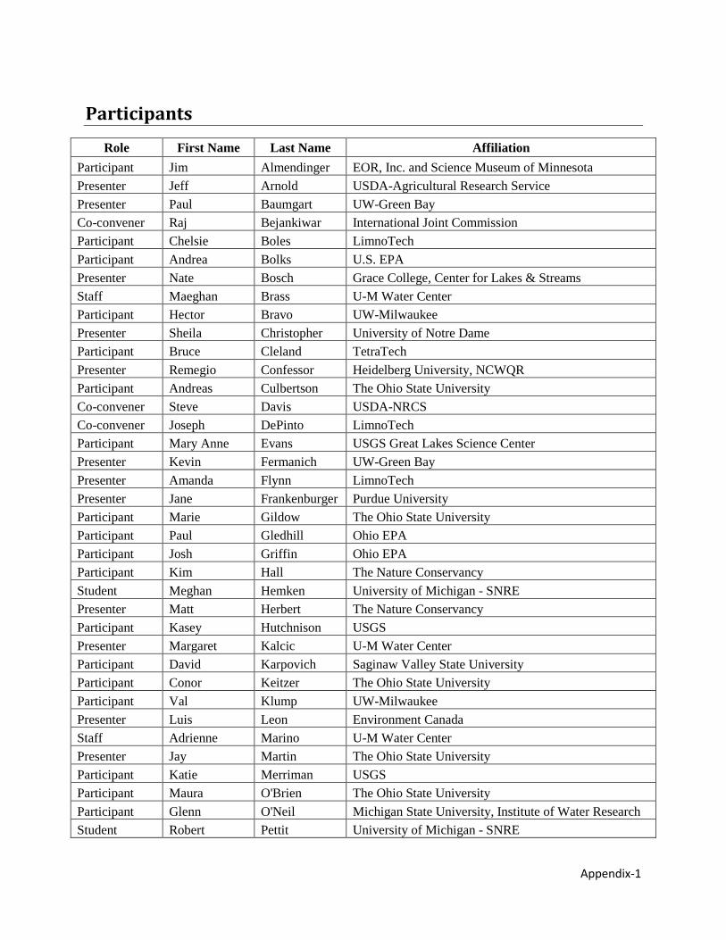
Participants
Role First Name Last Name Affiliation Participant Jim Almendinger EOR, Inc. and Science Museum of Minnesota Presenter Jeff Arnold USDA-Agricultural Research Service Presenter Paul Baumgart UW-Green Bay Co-convener Raj Bejankiwar International Joint Commission Participant Chelsie Boles LimnoTech Participant Andrea Bolks U.S. EPA Presenter Nate Bosch Grace College, Center for Lakes & Streams Staff Maeghan Brass U-M Water Center Participant Hector Bravo UW-Milwaukee Presenter Sheila Christopher University of Notre Dame Participant Bruce Cleland TetraTech Presenter Remegio Confessor Heidelberg University, NCWQR Participant Andreas Culbertson The Ohio State University Co-convener Steve Davis USDA-NRCS Co-convener Joseph DePinto LimnoTech Participant Mary Anne Evans USGS Great Lakes Science Center Presenter Kevin Fermanich UW-Green Bay Presenter Amanda Flynn LimnoTech Presenter Jane Frankenburger Purdue University Participant Marie Gildow The Ohio State University Participant Paul Gledhill Ohio EPA Participant Josh Griffin Ohio EPA Participant Kim Hall The Nature Conservancy Student Meghan Hemken University of Michigan - SNRE Presenter Matt Herbert The Nature Conservancy Participant Kasey Hutchnison USGS Presenter Margaret Kalcic U-M Water Center Participant David Karpovich Saginaw Valley State University Participant Conor Keitzer The Ohio State University Participant Val Klump UW-Milwaukee Presenter Luis Leon Environment Canada Staff Adrienne Marino U-M Water Center Presenter Jay Martin The Ohio State University Participant Katie Merriman USGS Participant Maura O'Brien The Ohio State University Participant Glenn O'Neil Michigan State University, Institute of Water Research Student Robert Pettit University of Michigan - SNRE
Appendix-2
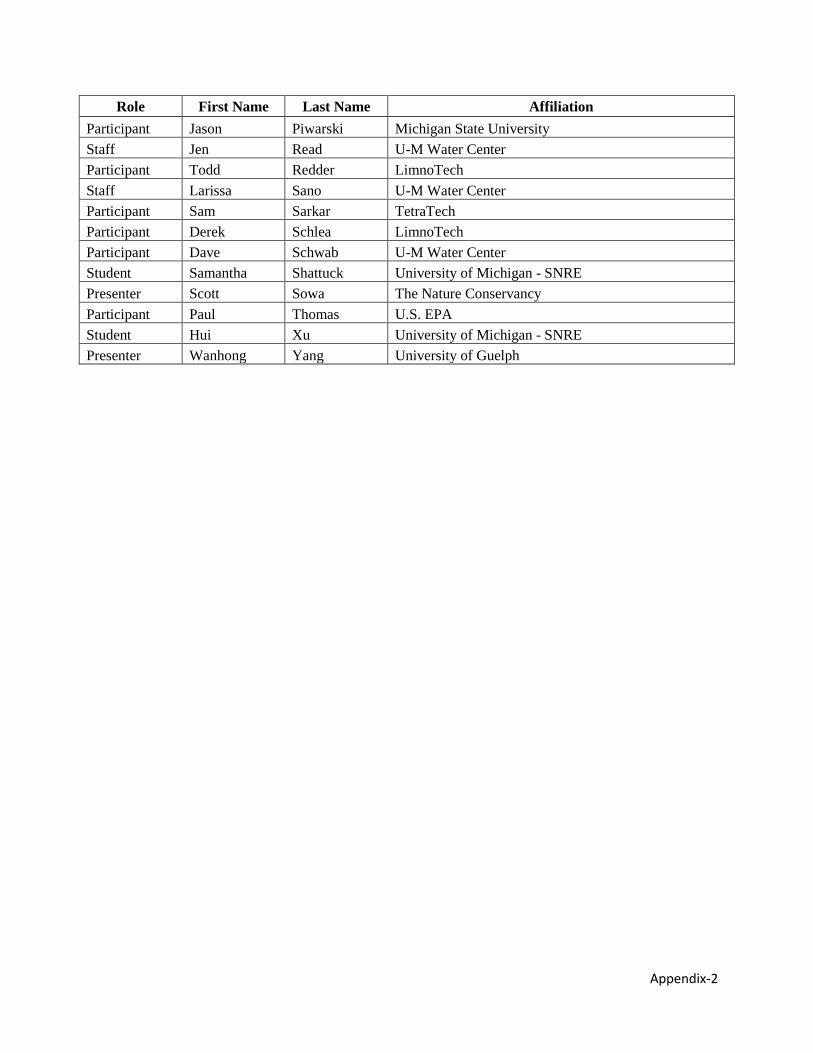
Role First Name Last Name Affiliation Participant Jason Piwarski Michigan State University Staff Jen Read U-M Water Center Participant Todd Redder LimnoTech Staff Larissa Sano U-M Water Center Participant Sam Sarkar TetraTech Participant Derek Schlea LimnoTech Participant Dave Schwab U-M Water Center Student Samantha Shattuck University of Michigan - SNRE Presenter Scott Sowa The Nature Conservancy Participant Paul Thomas U.S. EPA Student Hui Xu University of Michigan - SNRE Presenter Wanhong Yang University of Guelph
Appendix-3
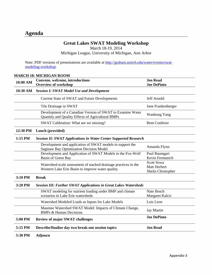
Agenda
Great Lakes SWAT Modeling Workshop March 18-19, 2014
Michigan League, University of Michigan, Ann Arbor
Note: PDF versions of presentations are available at http://graham.umich.edu/water/events/swat-modeling-workshop.
MARCH 18: MICHIGAN ROOM
10:00 AM Convene, welcome, introductions Overview of workshop
Jen Read Joe DePinto
10:30 AM Session I: SWAT Model Use and Development
Current State of SWAT and Future Developments Jeff Arnold
Tile Drainage in SWAT Jane Frankenberger
Development of a Canadian Version of SWAT to Examine Water Quantity and Quality Effects of Agricultural BMPs Wanhong Yang
SWAT Calibration: What are we missing? Rem Confesor
12:30 PM Lunch (provided)
1:15 PM Session II: SWAT Applications in Water Center Supported Research
Development and application of SWAT models to support the Saginaw Bay Optimization Decision Model Amanda Flynn
Development and Application of SWAT Models in the Fox-Wolf Basin of Green Bay
Paul Baumgart Kevin Fermanich
Watershed-scale assessment of stacked drainage practices in the Western Lake Erie Basin to improve water quality.
Scott Sowa Matt Herbert Sheila Christopher
3:10 PM Break
3:20 PM Session III: Further SWAT Applications in Great Lakes Watersheds
SWAT modeling for nutrient loading under BMP and climate scenarios in Lake Erie watersheds
Nate Bosch Margaret Kalcic
Watershed Modeled Loads as Inputs for Lake Models Luis Leon
Maumee Watershed SWAT Model: Impacts of Climate Change, BMPs & Human Decisions Jay Martin
5:00 PM Review of major SWAT challenges Joe DePinto
5:15 PM Describe/finalize day two break-out session topics Jen Read
5:30 PM Adjourn
Appendix-4
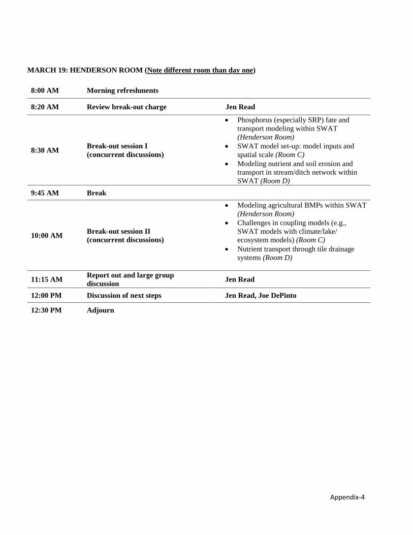
MARCH 19: HENDERSON ROOM (Note different room than day one)
8:00 AM Morning refreshments
8:20 AM Review break-out charge Jen Read
8:30 AM Break-out session I (concurrent discussions)
• Phosphorus (especially SRP) fate and transport modeling within SWAT (Henderson Room)
• SWAT model set-up: model inputs and spatial scale (Room C)
• Modeling nutrient and soil erosion and transport in stream/ditch network within SWAT (Room D)
9:45 AM Break
10:00 AM Break-out session II (concurrent discussions)
• Modeling agricultural BMPs within SWAT (Henderson Room)
• Challenges in coupling models (e.g., SWAT models with climate/lake/ ecosystem models) (Room C)
• Nutrient transport through tile drainage systems (Room D)
11:15 AM Report out and large group discussion Jen Read
12:00 PM Discussion of next steps Jen Read, Joe DePinto
12:30 PM Adjourn
Appendix-5
Great Lakes SWAT Modeling Workshop Recommendations The following is a master list of recommendations, improvements, and research needs identified during the five breakout discussion sessions during the Great Lakes SWAT modeling workshop. Breakout sessions included:
1. Phosphorus fate and transport modeling within SWAT, including nutrient transport through tile drainage systems
2. Comparing models: model outputs, set-up, and inputs 3. Modeling nutrient and soil erosion and transport in stream/ditch network within SWAT 4. Modeling agricultural BMPs within SWAT, including considerations of spatial scale 5. Challenges in linking/coupling SWAT models with other models (e.g., climate, lake,
ecosystem models) Recommendations for SWAT developers
Related to nutrient (especially phosphorus) and sediment dynamics • Re-label P forms in SWAT documentation and model output so they are
consistent with soil science and surface water science understanding of P. o There are three forms of P on the land, and then lumped into two in the
reach, and so some terms have multiple definitions. Sed P, Org P, Min P at HRU (edge-of-field) and Org P and Min P at reach (in and out, settling out) (Min P = Sol P + Sed P).
o Nomenclature is confusing, and we also need to refine the model to include more P forms.
o For more, see P. M. Haygarth and A. N. Sharpley. 2000. Terminology for Phosphorus Transfer. Journal of Environmental Quality, 29:1(10-15). doi:10.2134/jeq2000.00472425002900010002x.
• Add an SRP model output. Policies are SRP focused. Modelers are currently using a “work around” comparing mineral P to SRP, but the community needs SRP to be modeled explicitly.
o One way SWAT could deal with SRP/dissolved P is put in a constant partitioning factor as a calibration parameter. However, this probably changes as you move across the landscape, so this may not be a good approach.
• Include nutrient concentrations in output files, just like sediment concentrations are included.
• Permit the model to have different P sorption indices for different HRUs o Katie Merriman may have some field data that can be used to calibrate
these parameters if they were to exist. • Develop a better stream/ditch phosphorus transport model to replace QUAL-2E
o The HSPF model captures in-stream dynamics well – could it interface with SWAT?
Appendix-6
o A simple option for nutrient transport may be to link organics to sediments in channel (Paul Baumgart)
• Add LimnoTech’s new routine for ephemeral gully erosion to SWAT. Related to HRUs:
• Add field-level setup as an option in the ArcSWAT interface. Field-scale HRUs would be advantageous because management files can match specific field management.
• Develop guidance for best practices related to dividing fields. • Develop an option to use a simpler SWAT model that can go down to a very
detailed scale for a large basin. Each HRU would have one soil (critical or majority?) and average slope.
Related to “SWAT Check:” • Make changes to SWAT check to clear up confusion about P partitioning,
specifically including definitions of the P pools (“mineral” and “organic” and what these include).
• Include dissolved P in tile in SWAT check as a “soft data” check. • Consider including other nutrients (N forms) in SWAT check as well, if they are
not already included • Add BMPs to SWAT check
Related to BMPs: • Update the SWAT BMP manual so that new BMP ideas and methods can be
included. o This would allow storage of modular code and data files in one place,
making it easier for to build a master file of these so they don't need to be reinvented by various users.
o Store on the cloud or a server. o Create a steering committee to provide quality control and to approve and
upload files for everyone to access. o Provide an interface that allows users to search and select files they need,
rather than recreating each time. • Standardize how BMPs are implemented in SWAT. • Improve simulation of a variety of landscape depressions, including contributing
and non-contributing perennial ponds and upland depressions. Related to data sharing and accessibility:
• Create a website specifically for developers. Features may include: o User group for blogging and making sure everyone's up to speed about
what people are doing around the world o Archived code and datasets – developers can grab, use and test their
versions o Newest version of code
• Develop a SWAT database that: o Allows people to upload their data, coefficients, data, and metadata on a
tillage implement or management system. Some of that data comes with
Appendix-7
model (e.g. tillage), but as we recode, all the files will be that way (e.g. subsurface drain file with all management spacings and depths of all different subsurface tile management)
o Includes a master file that you can add to, users pick from, point to which one they need.
o Includes some way to allow users and developers to get their data into the master databases.
o Includes appropriate metadata (follows specific metadata standards) o Is more description oriented, with background explanation.
Related to climate data: • Include explicit handling of water temperature, including a better coupling of
stream and groundwater temperature. • Create a depository of climate scenario data, pre-formatted for SWAT
Recommendations for SWAT users
Related to nutrient (especially) phosphorus and sediment dynamics: • Determine reasonable bounds for P partition ratios to use as a “soft data” check.
o Perhaps this could be minimum, maximum, and mean values within rivers/streams from the literature.
o You can tweak and customize the proposed parameter for SRP partitioning to make sure your model falls in a reasonable range of SRP loading.
o A modeler could also use meta-analysis to determine where on the continuum they feel their particular watershed should fall.
• Determine if utilizing SWAT to target and prioritize for mineral P, rather than SRP, makes sense. Perhaps chemists could run experiments to determine total dissolved P, which includes organic and inorganic P.
• Use Heidelberg data on SRP and TP to determine reasonable partitioning and for calibrations. Compare mineral P (SWAT output) with SRP (measured data) as well as TP from SWAT outputs and measured data.
• Develop application to predict ecosystem habitat changes, e.g., deposition hot spots.
Related to HRU thresholds: • Consider how scaling is dependent on the questions you are asking with your
modeling. With conservation tillage or crop rotation - you can have a larger threshold. However, structural BMPs occur at a smaller scale, so you may need a smaller threshold.
• Consider computational time. Scaling matters for issues of computational time but also making sense of massive output.
• Define HRU resolution (threshold) based on the level of decision-making for land decisions. That gets to what you need for your BMPs, or land use change.
Related to BMPs:
Appendix-8
• Compile data from BMPs tested around the country. Existing databases include these developed by Katie Merriman1 and Margaret Gitau2, and the Minnesota e Agriculture BMP Assessment & Tracking Tool.
• Publish a literature review describing how BMP coefficients are set. Related to data sharing:
• Assess BMP performance using edge-of-field data. • Share edge-of-field monitoring data in a centralized location so all users may
access it. • Share “hard” and “soft” data.
Related to climate data: • Develop a common base model for climate change applications/questions
Research needs
Related to nutrient (especially) phosphorus and sediment dynamics: • P partitioning in general, and specifically partitioning between TP and SRP. • Research to consider whether a linear isotherm or a Freundlich (which has saturation
if you add too much SRP to the soil) is more suitable for a dynamic P sorption index. • Understanding tile drainage – flow and nutrient transport. Studies are needed to
understand tile drainage dynamics based on drain spacing, depth, gradient, and drivers.
o How much dissolved P (and all forms of P?) is entering into the tiles; o Macropore prevalence (knowledge model gap)
• Better understanding of different sources of phosphorus, e.g., combined sewer overflows, septic systems, tile drains. (Septic is source of N. What about septic failures? Has anyone evaluated this quantitatively?)
• Are there easier ways to access existing data, e.g., reported P from NPDES permit data?
• Test and validate sediment routing modules. Related to BMPs:
• Improved understanding of coefficients for BMP effectiveness and how they apply under various conditions
• How accurate are the various BMP coefficients for the Great Lakes region? Are they the best available? How are they set?
• What are the effects of various BMPs on P? How do different BMPs compare? (e.g., tillage vs converting to forage may increase vs. converting to wetlands - how much P retention, sink or source? Bounding predictions, idea of variance)
Related to climate change:
1 Merriman, K., M. Gitau, and I. Chaubey. 2009. A tool for estimating Best Management Practice effectiveness in Arkansas. Applied Engineering in Agriculture. 25(2): 199-213 2 Gitau, M. W., W. J. Gburek, A. R. Jarrett. 2005. A tool for estimating best management practice effectiveness for phosphorus pollution control. J. Soil Water Conserv. 60(1):1-10.
Appendix-9
• What are key interactions between climate change (storms) and geomorphology and how can they be modeled?
• Better understanding of uncertainties both in SWAT and climate models. • What are the different approaches for scaling to unmodeled areas, and how do the
different approaches affect the outputs? Related to ensemble modeling efforts:
• Evaluate how different models in the same watershed (e.g., the Maumee) compare using a three-phase approach o Phase I: Take the models as they are and run based on the parameters such as
increased precipitation, land use change, BMPs, etc.; output would be a report and recommendations for model tweaks and adjustments.
o Phase II: Run models with tweaks and adjustments and compare them o Possible phase III: super model; maybe a web-based one so it can be more widely
used Monitoring needs
• More repeated sampling at fixed stations (fish gage network?) for biological endpoints. Model accuracy would be improved.
• Increase edge-of-field monitoring efforts