wisconsin department of transportation (wisdot) stand
TRANSCRIPT

1 of 5
Wisconsin Department of Transportation (WisDOT) Stand-alone Signals and ITS Program
FY17 Project Application Form GENERAL INSTRUCTIONS
APPLICATIONS DUE: FEBRUARY 16, 2016
Please upload applications to the SharePoint site under your Region (https://wisdot.sharepoint.com/sites/dtsd/bto/its-sig/2017/SitePages/Home.aspx).
Each Region requesting funds from the Stand-alone Signals and ITS Program must submit the following information: Stand-alone Signals and ITS Program Region Ranking Spreadsheet (one per Region) Completed Stand-alone Signals and ITS Program FY17 Project Application Forms (one for each project request) Any supporting materials deemed necessary by the Region FY17 Project Application Form: Each FY17 Project Application Form shall be completed entirely to be considered: Box 1 Fill in those areas that are applicable to your project. Provide a project name to be used consistently when referring to the
proposed project. For ‘Name of Road/Intersection,’ use From-To (South-North or West-East) format for a road segment such as “6th St.-9th St.” A proposed project may involve multiple improvement locations; if this is the case, indicate the corridor or the general area of the proposed project. More specific information should be provided in the project description.
Box 2 Identify and describe area of improvement needed. Box 3 Describe the project in as much detail as possible. A good, detailed, description explaining how the project will
address the identified need(s) is essential for application review and evaluation. Box 4 If your project will be constructed in phases throughout multiple years, then provide the project costs in the
appropriate year and describe each in your proposed improvement statement. List major construction items and associated estimates such as new traffic signal installation, intersection channelization. Project expense is considered during the evaluation of the projects. Therefore, ALL COSTS (including design, utilities and R/E) should be provided regardless of whether Program funds will be used for all elements of the project.
Box 5 Complete the various questions as they relate to the proposed project. This information will help determine need and may help with ranking of projects among regions.
Box 6 Provide contact information for application sponsor’s primary contact person. Application must be signed by the regional operations chief to commit funds and certify as to the answers provided in the application.
Supporting Materials: Each completed application shall include the following, if applicable:
Map of location General Sketch of Project Proposal or site photo(s). An adequate sketch is the minimum requirement. Preliminary plan
layout sheets or study reports should be provided if available. Warrant Documentation, required only for proposals to install new traffic signals (example worksheet available
upon request. Ref: Manual on Uniform Traffic Control Devices [MUTCD], Part IV, Sec C). Completed Traffic Control Signal Approval Request form DT1199 (Required for all proposals to install new
traffic signals on the State Trunk Highway System, including Connecting Highways and ramp terminals). Systems Engineering Analysis. A SEA may need to be completed for certain types of projects funded by this
Program. Submittal Instructions & General Questions:
Questions on application process and Program contact: David Karnes
[email protected] Bureau of Traffic Operations
433 W. St. Paul Ave, Suite 300, Milwaukee, WI 53203 (414) 220-6804
Submit the application and materials to:
Upload all application materials to the SharePoint site under your Region
(https://wisdot.sharepoint.com/sites/dtsd/bto/its-sig/2017/SitePages/Home.aspx).

2 of 5
Wisconsin Department of Transportation (WisDOT) Stand-alone Signals and ITS Program
FY17 Project Application Form 1. Project Description
PROJECT NAME Replace Existing Signals
FILE NAME (AA_BBBB_FY17 Standalone Program App_CCC.docx)* 04_Replace Existing Signals_FY17 Standalone Program App_20160211.Docx
*File should be named consistently with the following nomenclature: AA=Project Regional Rank; BBBB=Project Name; CCC=Date.
NAME OF ROAD/INTERSECTION
Various HWY NO.
Various COUNTY
MIL, OZA, WAU CITY/TOWN
Various REGION
SE Region
2. Identification of Needs Identify which area for improvement the need falls under:
1. New Signal Installation Procurement and installation of controllers, bases and signals 2. Signal Replacement Replacement of signals including geometric improvements and upgrades for FY17 construction 3. Signal Rehabilitation Upgrade, install or replace detection, controllers, battery backup, etc.
4. Signal Retrofit Procure and install monotubes, procure and install flashing yellow arrows, safety improvements not requiring major construction and adaptive signal systems.
5. Signal Retiming Data collection, evaluation, prepare signal timing plan, develop and implement corridor coordination plan to support 3 and 5 year timing schedule
6. LED Signal Replacement* Procure and install all materials for annual LED signal 7 year replacement cycle
7. Intersection Communication Design-build and integrate fiber optic links between existing fiber infrastructure and signal systems, or procure and install cellular Ethernet modems
8. ITS Device Lifecycle Replacement Upgrade, install or replace detection, controllers, battery backup, etc. 9. Software Upgrade, install or replace software
10. ITS Device Installation Upgrade backbone fiber network equipment and switches, replace ramp meter LED’s, update non standard CCTV’s
Other
*Anticipated improvements are understood for LED Signal Replacement projects. Therefore, it is only necessary to respond to the Project Description (3a) and Existing Conditions (3b) questions in section 3. 3. Proposed Improvements 3a. Project Description
In some detail, describe the proposed project and how it will address the identified need. If the project includes multiple proposed improvement locations, identify the locations. These intersections have aging facilities with maintenance challenges, potentially resulting in operational consequences. The proposed project will replace all existing traffic signal equipment based on current standards/practices. A cell modem may also be installed at the intersections to provide remote communication. The design includes 6 intersections. S40-1072 STH 100 & National Ave, S40-1073 STH 100 & Oklahoma, S40-1088 STH 100 & Lincoln, S40-1104 STH 100 & Cleveland, S45-0412 STH 33 & CTH O (Mill St), and S67-0457 STH 16 NB Ramps & STH 67

3 of 5
3b. Existing Conditions
Describe the existing conditions of the existing infrastructure. For example, type and age of current infrastructure; what is its current condition?
The intersections’ last full reconstruction date is listed below.
Signal Number
Reconstruction date
S40-1073 1982
S40-1072 1999
S40-1104 1999
S40-1088 1999
S45-0412 1990
S67-0457 1992
3c. Project Performance Goals and Objectives
Describe the proposed project performance goals and objectives. How will project success be determined?
This project has the following performance goals and objectives:
Goal – Reduce the effort required for maintenance due to old intersection equipment. Objective – Eliminate 80% of maintenance tickets for failing infrastructure at these signalized
intersections.
Goal – Increase remote communication to signals in the SE Region. Objective – Install and achieve remote communication to signals.
3d. Mobility Improvements
In some detail, describe the anticipated mobility improvements of the proposed project and how they will be measured (i.e. detection will be used to determine before and after peak hour delay).
Although there is not a direct mobility benefit expected, the remote communication will lead to better monitoring of the intersection, allow modifying the signal operations remotely, and address minor maintenance concerns.
3e. Operations and Maintenance Impacts
In some detail, describe how this project will efficiently use or reduce operations and maintenance funds.
Maintenance needs will be reduced with the replacement of aged signal equipment. Signal operations and maintenance will also be improved with the enhanced monitoring due to the remote communication. This communication will assist in responses to concerns and complaints. The communication will provide the ability to collect intersection performance measures.

4 of 5
3f. Energy and Environmental Impacts In some detail, describe the anticipated energy and environmental impacts of the proposed project.
Although there is not a direct environmental benefit expected, the remote communication will lead to better operational monitoring. This will reduce the number of trips to each intersection for minor timing revisions.
3g. Safety Improvements
In some detail, describe the anticipated safety improvements of the proposed project.
Monotube arms will allow a head per lane and enhance the visibility of the traffic signal. Head-per-lane indications are expected to reduce both angle and rear end collisions.
3h. Additional Justification
Provide additional detail that should be considered during the evaluation of this project. This may include the consequences of what would happen should the project not be implemented. The design for these signal replacements will be under one contract. The construction will be divided into two projects.
4. Project Cost
Estimate project costs in today’s dollars: FY17 FY18 FY19 FY20*
Design: $225,000
Real Estate: (Note: real estate acquisition funds are NOT included in this appropriation, other funding sources need to be identified in the space below)
Construction Items (Include Construction Engineering and Contingencies):
(Note: up to 50% of the geometric improvements needed can be funded by this appropriation )
Let construction $1,400,000
Installation via procurement contracts $400,000
State furnished materials $200,000 $100,000
Other Costs:
**TOTAL COST = $225,000 $1,600,000 $500,000 * The program does not extend passed FY18, however for planning purposes please include potential projects for FY20 which could be funded through a reauthorization of this program or an alternate funding source. ** The project sponsors will be responsible for any project costs in excess of the approved appropriation funding amount. Appropriation funds must be encumbered during the FY identified.

5 of 5
5. Additional Project Information Is this specific project addressed through PDS within the next 6 years? YES NO
Performance measures: does this project help with achieving WisDOT’s performance goals? Refer to http://dotnet/mapss/index.htm Mobility: Delivering transportation choices that result in efficient trips and no
unexpected delays. Accountability: The continuous effort to use public dollars in the most efficient
and cost-effective way. Preservation: Protecting, maintaining and operating Wisconsin's transportation
system efficiently by making sound investments that preserve and extend the life of our infrastructure, while protecting our natural environment.
Safety: Moving toward minimizing the number of deaths, injuries and crashes on our roadways.
Service: High quality and accurate products and services delivered in a timely fashion by a professional and proactive workforce.
Select all that apply:
Mobility
Accountability
Preservation
Safety
Service
Is this project listed as a strategic objective in the State Traffic Operations Program Plan (STOPP)? Refer to \\Mad00fph\n4public\BHO\meeting-minutes\bto\stopp\
YES NO If yes, what section of the STOPP? Electrical & Communication System (6)
Timeline
Steps in process Months (MM/YY – MM/YY)
Anticipated Quarter of
Encumbrance
Anticipated Required Resources (Reg PDS, Reg OPS (eng, electricians), consultant contract, electrical contractors, etc.)
1. Design 07/16‐06/17 Q3 Consultant Contract
2. Real Estate Acquisition
3. Procurement
4. Construction
5. Other
6. Contact Information and Signature
PRIMARY CONTACT NAME Elizabeth Lloyd-Weis
TITLE Signal Operations Engineer - Lead
REGION SE Region EMAIL ADDRESS [email protected]
TELEPHONE 262-521-4404
SIGNATURE OF OPERATIONS SUPERVISOR
John A Haug
DATE 2-9-16
SIGNATURE OF OPERATIONS CHIEF
David Nguyen
DATE 2/11/16
REVISED DRAFT 10/31/2015

OZAUKEE COUNTY
STH 33 & CTH O (Mill St)


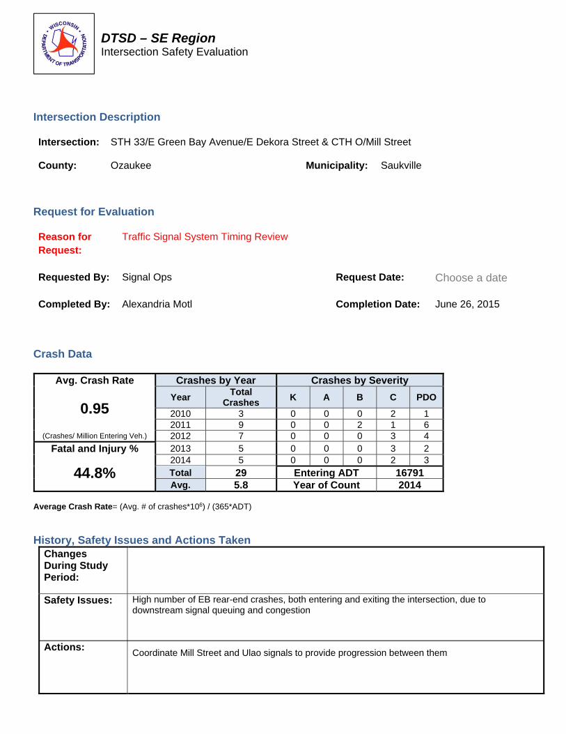
DTSD – SE Region Intersection Safety Evaluation
Intersection Description Intersection: STH 33/E Green Bay Avenue/E Dekora Street & CTH O/Mill Street
County: Ozaukee Municipality: Saukville
Request for Evaluation Reason for Request:
Traffic Signal System Timing Review
Requested By:
Signal Ops Request Date: Choose a date
Completed By:
Alexandria Motl Completion Date: June 26, 2015
Crash Data
Avg. Crash Rate Crashes by Year Crashes by Severity
0.95 Year
Total Crashes
K A B C PDO
2010 3 0 0 0 2 1 2011 9 0 0 2 1 6
(Crashes/ Million Entering Veh.) 2012 7 0 0 0 3 4
Fatal and Injury % 2013 5 0 0 0 3 2
44.8% 2014 5 0 0 0 2 3 Total 29 Entering ADT 16791 Avg. 5.8 Year of Count 2014
Average Crash Rate= (Avg. # of crashes*106) / (365*ADT)
History, Safety Issues and Actions Taken Changes During Study Period:
Safety Issues: Actions:
High number of EB rear-end crashes, both entering and exiting the intersection, due to downstream signal queuing and congestion Coordinate Mill Street and Ulao signals to provide progression between them

DTSD – SE Region Intersection Safety Evaluation
STH 33/E Green Bay Avenue/E Dekora Street & CTH O/Mill Street
Ozaukee County 2010-2014
LEGEND
Signal/Sign Post Bicycle Right Angle Out of Control (S) = SNOW-ICE K = FATAL
Tree/Utility Pole Pedestrian Left Turn Rear-End (W) = WET A = INCAPACITATING
Non-Fixed Object Non-Contact Vehicle Right Turn Head-On (F) = FOG-MIST B = NON-INCAP.
Fixed Object Backing Vehicle Sideswipe-Same Overtake (DUI) = ALCOHOL C = POS. INJURY
Parked Vehicle Moving Vehicle Sideswipe-Opp. Overturn OR DRUG USE BLANK = PDO
3/11/10 C (W) 5/26/10 C 1/6/11 9/25/12 10/18/14 11/26/14 C
8/26/10
4/4/11 B 11/11/12 C (W) 12/28/12 7/4/13
4/4/11 C 4/15/11 (W) 8/23/12 C 6/1/13 C 10/20/13 C 3/14/14 9/22/14 C
5/26/11 12/2/11 1/3/12
6/24/11 B
11/25/11
12/8/11 7/7/12
6/30/12 C
2/8/13 C (W)
10/31/13 (W)
8/22/14

WAUKESHA COUNTY
STH 16 NB Ramp & STH 67


DTSD – SE Region Intersection Safety Evaluation
Intersection Description
Intersection: STH 16 NB & STH 67
County: Waukesha Municipality: Town of Oconomowoc
Request for Evaluation
Reason for Request:
Click here to enter text. 5% list (include year), redesign, etc.
Requested By: Stephanie Sward Request Date: January 6, 2016
Completed By: Mike Borck Completion Date: January 8, 2016
Crash Data
Avg. Crash Rate Crashes by Year Crashes by Severity
.65 Year
Total Crashes
K A B C PDO
2010 2 2 2011 10 1 1 3 5
(Crashes/ Million Entering Veh.) 2012 6 2 1 3
Fatal and Injury % 2013 4 1 3
42%
2014 4 4 Total 26 0 3 3 5 15 Avg. 5.2 ADT 21,844
Pre 2015 2 Year of Count 2013 Average Crash Rate= (Avg. # of crashes*106) / (365*ADT) Preliminary 2015 crashes not included in calculations HSM spreadsheet: N:\SPO\Operations\Safety\Intersection, Segment & Project Files\SER Signals.xlsx (Add crash and volume statistics)
History, Safety Issues and Actions Taken Changes During Study Period:
Safety Issues:
Actions:

DTSD – SE Region Intersection Safety Evaluation
STH 16 NB & STH 67
Waukesha County January 2010- Pre. 2015
LEGEND
Signal/Sign Post Bicycle Right Angle Out of Control (S) = SNOW-ICE K = FATAL
Tree/Utility Pole Pedestrian Left Turn Rear-End (W) = WET
A = INCAPACITATING
Non-Fixed Object Non-Contact Vehicle Right Turn Head-On (F) = FOG-MIST
B = NON-INCAP.
Fixed Object Backing Vehicle Sideswipe-Same Overtake (DUI) = ALCOHOL
C = POS. INJURY
Parked Vehicle Moving Vehicle Sideswipe-Opp. Overturn OR DRUG USE
BLANK = PDO
7/9/2010, A
STH 16
STH 67 NB
1/3/2011, (S)
2/18/2011, B 7/21/2012, B 8/4/2012, B (W) 9/29/2013, C 11/8/2014
3/19/2011 7/11/2011, A, (W) 11/12/2011 5/7/2015, C
5/1/2011, C 8/23/2011 6/6/2012
7/24/2011, C
5/2/2013, (W), (DUI)
2/19/2013, (W)
12/10/2013, (W)
10/3/2011 8/4/2012, (W) 4/5/2014 6/7/2014 2/24/2015, C
6/27/2011, C, (W)
10/26/2010, A, Swerved to miss car from south
12/17/2012
5/12/2012, C
9/9/2014

MILWAUKEE COUNTY
STH 100 & Lincoln AveSTH 100 & Cleveland Ave STH 100 & National Ave STH 100 & Oklahoma Ave


DTSD – SE Region Intersection Safety Evaluation
Intersection Description Intersection: STH 100/S. 108th Street and Lincoln Avenue
County: Milwaukee Municipality: West Allis
Request for Evaluation Reason for Request:
Signal Review
Requested By:
Signal Ops Request Date: December 28, 2015
Completed By:
Brian Weinfurt Completion Date: January 14, 2016
Crash Data
Avg. Crash Rate Crashes by Year Crashes by Severity
.83 Year
Total Crashes
K A B C PDO
2010 12 2 1 9 2011 26 1 8 17
(Crashes/ Million Entering Veh.) 2012 23 2 6 15
Fatal and Injury % 2013 25 5 8 12
42%
2014 28 4 13 11 Total 114 13 35 64 Avg. 22.8 ADT 52156
Pre 2015 12 Year of Count 2012 Average Crash Rate= (Avg. # of crashes*106) / (365*ADT) Preliminary 2015 crashes not included in calculations HSM spreadsheet: N:\SPO\Operations\Safety\Intersection, Segment & Project Files\SER Signals.xlsx (Add crash and volume statistics)
History, Safety Issues and Actions Taken Changes During Study Period:
Safety Issues:
Actions:

DTSD – SE Region Intersection Safety Evaluation
STH 100/S. 108th Street and Lincoln Avenue
Milwaukee County January 2010 to Pre-2015
LEGEND
Signal/Sign Post Bicycle Right Angle Out of Control (S) = SNOW-ICE K = FATAL
Tree/Utility Pole Pedestrian Left Turn Rear-End (W) = WET A = INCAPACITATING
Non-Fixed Object Non-Contact Vehicle Right Turn Head-On (F) = FOG-MIST B = NON-INCAP.
Fixed Object Backing Vehicle Sideswipe-Same Overtake (DUI) = ALCOHOL C = POS. INJURY
Parked Vehicle Moving Vehicle Sideswipe-Opp. Overturn OR DRUG USE BLANK = PDO
3/2/10 3/15/10 1/17/11, (S) 1/20/11, C 7/12/11 7/18/11 11/14/11, (W) 11/29/11 5/24/12 6/6/12, C 10/14/12, (W) 12/21/12, C 1/11/13, (W) 1/26/13 1/26/13 5/13/13, B 7/26/13, B, (W) 2/11/14 3/3/14 6/24/14 8/12/14, C 8/26/14 8/27/14, C 11/3/14, C 11/15/14, C 11/27/14, C 12/10/14
5/29/10 12/21/10, (W) 1/22/11 4/15/11, (W) 5/20/11 7/13/11 8/5/11 9/16/11, C, (W) 10/15/11, C 2/20/12, C 5/15/12 6/3/12 9/10/12 11/6/12, (W) 8/17/12, C 10/17/12, (W) 3/5/13, (S) 3/11/13, B, (S) 5/16/13, C 7/3/13 10/3/13, C 11/8/13 4/26/14 2/16/15, B 4/30/15 10/8/15, C
1/25/11, (W) 3/30/10 3/29/13 5/16/14 6/10/14, C 11/5/14
2/25/10, (S) 1/11/11, C, (S) 9/28/13, C, (W) 8/4/14, C 10/28/14, C
7/22/11, (W) 7/22/13, C 10/4/13, C, (W) 11/21/14 6/2/15
8/8/11 10/13/11, (W) 11/16/11, C 11/28/11 1/8/12, C 10/12/12 1/8/13, C
12/14/11, C, (W) 2/24/12 5/30/12 1/29/13, C, (W) 4/6/13, (W) 7/23/13 8/29/13, B 2/15/14, C 3/14/14, C 6/15/14, C 9/4/14 10/13/14, B, (W) 7/10/15 10/29/15, C (W)
12/18/10, B 9/24/12 7/12/13, C 9/3/13, B 10/6/15
5/12/12 1/29/10
7/17/11
4/15/12, (W) 4/3/13 9/22/13 4/26/15
10/24/11, C 10/26/10, (W)
2/10/12 1/10/14, (S) 5/23/14
8/10/12 12/17/13, (W)
8/7/12, B
7/28/10, B 8/16/11, C
9/7/12, C 4/27/15, B
9/6/10 5/5/11 8/18/11, B 10/12/14, C
4/24/12, B 4/25/14, B. (W) 3/3/15, (S) 5/1/15, (W) 11/16/15, B
1/20/10, C
4/10/14, C 6/6/14, B

MH
MH
MH
AG
MH
WV
WV
MH
MH
MH
MH
MH
MH
WV
GV
GV
MH
WVW
V
WV
WV
WV
WV
WV
WV
WV
WV
GV
15’
B
B
*
*
****
* *
* *
*
B
B
B
B
B
MH
MH
MH
MH
MH
MH
MH
MH
MH
MH
MH
MH
MH
15’
MH
SB1
SB2
SB3
SB4
SB5
SB6
SB7
SB8
SB9
SB10
SB11
SB12
PB1
PB2
PB6
PB7
PB8
PB9PB10
PB12
PB13
PB14
PB15
PB16
PB18
PB19
PB20
PB21
PB22PB23
PB26
2-3"
4-3"2-3"
2-3"2-3"
2-3"
2-3"
2-3"
2-3"2-3"
2-3"
2-3"
2-3"
2-3"
2-3"
YR G5
YR Y G G8
YR Y G G6
YR
G
7
A
Y RYGG 4
Y RYGG 2
Y RG 1
YR
G
3
B
Y
R
Y
G
G
14
Y
R
Y
G
G
16
Y
R
Y
G
G
10
Y
R
Y
G
G
12
Y
R
G
9
Y
R
G
15
D
C
22
19
18
21 24
17
20
23
PB11
PB24
SB13
SB14
PB4
PB5
2-3"
FTMS FOC
FTMS FOC
RIGHT SIGNAL
275’ TO NEAR
21
51
52
11 12
71
72
3 TURNS
6’X32’
3 TURNS
6’X20’3 TURNS
6’X25’2 TURNS EACH
2 - 6’X20’
3
TU
RN
S
6’X
30’
41 42
43 44
462
TU
RN
S
EA
CH
2 - 6’X
20’
N/
A
TU
RN
S
EA
CH
4 - 6’X
20’
Y
R
G
11
Y
R
G
13
*
V2
V3
V1
V4
A
A
C C
BB
STH 100 (S. 108TH STREET)
STH 100 (S. 108TH STREET)
W.
CL
EV
EL
AN
D
AV
EN
UE
W.
CL
EV
EL
AN
D
AV
EN
UE
OTHERWISE NOTED
NONMETALLIC CONDUIT 2", UNLESS
PEDESTAL BASE
SIGNAL HEAD, TRAFFIC SIGNAL STANDARD,
LUMINAIRE, TRAFFIC POLE, TRANSFORMER BASE
LUMINAIRE UNDER PERMIT TO LOCAL MUNICIPALITY
LEGEND
PUSH BUTTON
EVP DESIGNATOR
EVP DETECTOR HEAD
CONTROL CABINET
TRAFFIC SIGNAL HEAD
SIGNAL HEAD NUMBER
BB
PULL BOX, 24" X 36"
(XX)
TRANSFORMER BASE
SIGNAL HEAD, TRAFFIC SIGNAL POLE,
PUSH BUTTON
PEDESTRIAN HEAD WITH
LEGEND (CON’T)
RED CIRCULAR INDICATOR
YELLOW CIRCULAR INDICATOR
GREEN CIRCULAR INDICATOR
YELLOW ARROW
GREEN ARROW
NOTE:
G
Y
G
Y
R
CB1
TO AVOID CONFLICT WITH EXISTING UTILITY FACILITIES.
THE ENGINEER MAY ADJUST THE LOCATIONS OF ITEMS UNDER THIS CONTRACT
PROJECT WHICH ARE NOT SHOWN.
APPROXIMATE. THERE MAY BE OTHER UTILITY INSTALLATIONS WITHIN THE
THE LOCATIONS OF EXISTING AND PROPOSED UTILITY INSTALLATIONS ARE
2.
1.
CONSTRUCTION NOTES:
Date By Date By
CENTRAL OFFICE
Rev.
No.
R E V I S I O N
REGION
APPROVAL RECOMMENDED APPROVED
TRAFFIC CONTROL SIGNAL
TS-2
ECONOLITECONTROLLER TYPE:
CABINET TYPE:
SIGNAL NO.
WISCONSIN DEPARTMENT OF TRANSPORTATION
APPROVAL RECOMMENDED
2/4/64 Date
APPROVED
2/16/65 Date WAYNE N. VOLK
REGION TRAFFIC ENGINEER
STATE TRAFFIC ENGINEER
PAGE 1 OF3
REGION CONTACT: JUSTIN EFFINGER
DESIGNED BY:
REVISED BY: FORWARD 45
MILWAUKEE COUNTY
CITY OF WEST ALLIS
W. CLEVELAND AVENUE
STH 100 (S. 108TH STREET) &
HARVEY SHEBESTA
14
VX
VIDEO DETECTION AREA
VIDEO DETECTION CAMERAGRAYSHADE REPRESENTS EXISTING
ALL LENSES ARE 12 INCH
LIMIT=40 MPH
POSTED SPEED
LIMIT=40 MPH
POSTED SPEED
LIMIT
=25
MP
H
PO
ST
ED
SP
EE
D
LIMIT
=25
MP
H
PO
ST
ED
SP
EE
D
(COUNTDOWN TIMER)
WALK/DON’T WALK INDICATOR 16"
FO I/C
DATE OF INITIAL INSTALLATION9-3-65
INSTALLED INTERCONNECT CABLE8-7-67
ALSO RECABLED
INSTALLED NEW CABINET & CONTROLLER, 9-24-78
SIGNALS NB, SB
ADDED PED SIGNALS EB, WB; LEFT TURN 12-17-81
INSTALLED NEW CABINET AND CONTROLLER1-19-82
INSTALLED LEFT TURN SIGNALS9-8-82
REVISED SEQUENCE OF OPERATION5-23-88
RECONSTRUCT PORTIONS OF INTERSECTION SIGNAL5-11-99
FOR ALL APPROACHESEMERGENCY VEHICLE PREEMPTION INSTALLED4-6-00
LOOPS 11 & 51 ON CALL AND EXTEND7-20-04
R/W
R/W
R/
W
R/
W
R/W
R/W
R/
W
R/
W
ADAPTIVE CONTROL.
UPDATE DETECTION AND CABINET. ADD INSYNC
610
620
630
110
310 820 810
510
230
220
210
710430420
410
TO SB2 & SB8
TRANSFORMER BASES SECTION HEADS, ADD HEADS 11 & 14 TO 3 TO SB2 & SB8, CHANGEADD 5-SECTION HEADS 8-29-05
FIELD REVIEW
11-13-07
EVP SEQUENCE
CONTROLLER; UPDATED REPLACE CABINET AND 10-7-13
DETECTION
ADDED WB VIDEO02-14
WISDOT/CADDS SHEET 42
EHWY: COUNTY:
J:\projects\d2_signals_com\S1104_N.dgnFILE NAME : 18-NOV-2015 09:08 40:1PLOT SCALE : PLOT DATE : PLOT BY : dotcmv
2
PROJECT NO:1060-33-97 STH 100 MILWAUKEE
PLOT NAME : $FILE$
2
TRAFFIC SIGNAL PLAN SHEET
2/19/2014 3/6/2014
S40-1104

WV
WV
WV
*
*
MH
MH
MH
MH
MH
MH
*
VL
V
WV
MH
PB25
PB3
PB17
FTMS FOC
45
61
(S1072) 21
RIGHT SIGNAL
275’ TO NEAR
RIG
HT
SIG
NA
L
218’ T
O
NE
AR
3
TU
RN
S
6’X
20’
TRAFFIC CONTROL SIGNAL
SIGNAL NO.
PAGE 2 OF3DESIGNED BY:
REGION CONTACT: JUSTIN EFFINGER
REVISED BY: FORWARD 45
MILWAUKEE COUNTY
CITY OF WEST ALLIS
W. CLEVELAND AVENUE
STH 100 (S. 108TH STREET) &
A
A
B B
C C
STH 100 (S. 108TH STREET)
W.
CL
EV
EL
AN
D
AV
EN
UE
W.
CL
EV
EL
AN
D
AV
EN
UE
LIMIT=40 MPH
POSTED SPEED
LIMIT
=25
MP
H
PO
ST
ED
SP
EE
D
LIMIT
=25
MP
H
PO
ST
ED
SP
EE
D
FTMS FOC
R/W
R/W
R/
W
R/
W
R/
W
WISDOT/CADDS SHEET 42
EHWY: COUNTY:
J:\projects\d2_signals_com\S1104_N.dgnFILE NAME : 18-NOV-2015 09:08 40:1PLOT SCALE : PLOT DATE : PLOT BY : dotcmv
2
PROJECT NO:1060-33-97 STH 100 MILWAUKEE
PLOT NAME : $FILE$
2
TRAFFIC SIGNAL PLAN SHEET
S40-1104

FLA
S
HNUMBERS
HEAD
01
02
03
04
05
06
07
08
02P
04P
06P
08P
OLE
OLF
OLG
OLHNONE
TYPE OF PRE-EMPT
RAILROAD
EMERGENCY VEHICLE
LIFT BRIDGE
TOMAR
HARDWIRE
OTHER
QUEUE DETECTOR
TYPE OF LIGHTING
IN TRAFFIC SIGNAL CABINET
IN SEPARATE DOT LIGHTING CABINET
BY OTHER AGENCY
TYPE OF COORDINATION
NONE
TBC
TRAFFIC RESPONSIVE
XADAPTIVE
NONE
RADIO
-SIGNAL SYSTEM #: SS-
S-CONTROLLER NO:
*LOCATION OF MASTER
CLOSED LOOP
FIBER OPTIC (ETHERNET) X
00 14
X
X
X
TYPE OF INTERCONNECT/COMMUNICATION
TWISTED PAIR*
FIBER OPTIC*
RING 1
RING 2
BARRIER
N
EMERGENCY VEHICLE PREEMPTION SEQUENCE
A B
MOVEMENT
PHASE
C D
EMERGENCY VEHICLE
DETECTOR
-
R
-
-
-
R
R
R
13,14,15,16
21,22
17,18
23,24
19,20
9,10,11,12
14,16
2+6 6+2 4+8 8+4
CONTROLLER SHALL RETURN TO PHASES 4+8.
AFTER PREEMPTION SEQUENCE 4+8 OR 8+4,
OPTICOM
CONTROLLER SHALL RETURN TO PHASES 2+6.
AFTER PREEMPTION SEQUENCE 2+6 OR 2+6,
01
02 04
05
PHASE PHASE PHASE
NUMBER LOCKING
DUAL
ENTRY
CONTROLLER LOGIC
RECALL
1
2
3
4
5
6
7
8
W / 0/
6
6
8
8
2
2
4
4
PHASE
ACTIVE
X
X
X
X
X
X
07
08
03
06
MIN
MIN
X
X
DETECTOR INPUT
PLAN LOOP DETECTOR #(S)
CALLED PHASE
CALL OPTION
DELAY TIME
EXTEND TIME
USE ADDED INITIAL
CROSS SWITCH PHASE
EXTEND OPTION
DETECTOR INPUTDETECTOR INPUT
PLAN LOOP DETECTOR #(S)
CALLED PHASE
CALL OPTION
DELAY TIME
EXTEND TIME
USE ADDED INITIAL
CROSS SWITCH PHASE
EXTEND OPTION
DETECTOR LOGIC
2,4
5,6,7,8
10,12
6,8
1,2,3,4
MILWAUKEE COUNTY
02/14 3 3
SIGNAL NO.
DATE
CONTROLLER TYPE:
CABINET TYPE: TS2
PAGE NO. OF
ECONOLITE
CITY OF WEST ALLIS
S40-1104
STH 100 (S. 108TH STREET) &
W. CLEVELAND AVENUE
820
710
620
510
420
310
220
X
810
630
X
610
430
410
230
X
210
X X X X X
X
X X X X
X X
110
1 2 3 4 5 6 7 8
2 2 4 4 6 6 8
X X X X X X X X
X X X X X X X
X X
3 1 7 5 9 131511DETECTOR INPUT
4 2 8 6 10 141612DETECTOR INPUT
PLAN LOOP DETECTOR #(S)
6
61
X
X
4
46
X
X
X
4
X
X
1
X
X
7
X
X
5
X
X
4
45
X
X
X
X
2
X
X
4
21
X
6
4
2
X
CALLED PHASE
CALL OPTION
DELAY TIME
EXTEND TIME
USE ADDED INITIAL
CROSS SWITCH PHASE
PLAN LOOP DETECTOR #(S)
CALLED PHASE
CALL OPTION
DELAY TIME
EXTEND TIME
USE ADDED INITIAL
CROSS SWITCH PHASE
EXTEND OPTION
EXTEND OPTION
11/12
42/44
41/43 51/52 71/72
WISDOT/CADDS SHEET 42
EHWY: COUNTY:
J:\projects\d2_signals_com\S1104_N.dgnFILE NAME : 18-NOV-2015 09:08 40:1PLOT SCALE : PLOT DATE : PLOT BY : dotcmv
2
PROJECT NO:1060-33-97 STH 100 MILWAUKEE
PLOT NAME : $FILE$
2
SEQUENCE OF OPERATIONS SHEET

DTSD – SE Region Intersection Safety Evaluation
Intersection Description Intersection: STH 100 & Cleveland Ave
County: Milwaukee Municipality: West Allis
Request for Evaluation Reason for Request:
Signal Review
Requested By:
Signal Ops Request Date: December 28, 2015
Completed By:
Brian Weinfurt Completion Date: January 13, 2016
Crash Data
Avg. Crash Rate Crashes by Year Crashes by Severity
1.36 Year
Total Crashes
K A B C PDO
2010 26 4 6 16 2011 26 6 20
(Crashes/ Million Entering Veh.) 2012 22 1 7 14
Fatal and Injury % 2013 30 1 9 20
33%
2014 16 6 10 Total 120 6 34 80 Avg. 24 ADT 48171
Pre 2015 16 Year of Count 2012 Average Crash Rate= (Avg. # of crashes*106) / (365*ADT) Preliminary 2015 crashes not included in calculations HSM spreadsheet: N:\SPO\Operations\Safety\Intersection, Segment & Project Files\SER Signals.xlsx (Add crash and volume statistics)
History, Safety Issues and Actions Taken Changes During Study Period:
Safety Issues:
Actions:

DTSD – SE Region Intersection Safety Evaluation
STH 100 & Cleveland Ave
Milwaukee County Jan 2010 to Pre- 2015
LEGEND
Signal/Sign Post Bicycle Right Angle Out of Control (S) = SNOW-ICE K = FATAL
Tree/Utility Pole Pedestrian Left Turn Rear-End (W) = WET A = INCAPACITATING
Non-Fixed Object Non-Contact Vehicle Right Turn Head-On (F) = FOG-MIST B = NON-INCAP.
Fixed Object Backing Vehicle Sideswipe-Same Overtake (DUI) = ALCOHOL C = POS. INJURY
Parked Vehicle Moving Vehicle Sideswipe-Opp. Overturn OR DRUG USE BLANK = PDO
12/20/10, B, (S) 1/10/11, (W), (DUI) 9/9/12, (W)
7/16/10 2/1/14 (S)
5/1/10 11/16/10, C 11/24/10, B 3/17/11, C 5/24/12, C 9/17/12, C, (W) 11/27/12, C 12/12/12, C 4/9/13, C 5/2/13, C, (W) 10/4/13, (W) 10/15/13, C, (W) 6/16/14 1/22/15, C 2/2/15, (S) 3/11/15, B
9/22/10, B 2/19/11, C 12/2/13, C 6/24/14, C 1/21/15, (W)
7/14/10, C 9/27/11, (W) 11/17/15, (W)
4/3/10, (W) 5/25/11, C, (W) 7/29/11 8/14/11 12/21/11, C 1/17/12, (S) 4/27/12 7/20/12 12/14/12 12/21/12 1/11/13 2/8/13, C, (S) 4/19/13 5/15/13, C 6/21/13, C 7/22/13 8/5/13 8/16/13 11/17/15
4/22/10, C 4/28/10 5/27/11 9/6/11 10/28/11 2/10/12, (S) 11/27/12 12/23/12, (W), (DUI) 2/4/13, (S) 7/8/13 10/28/14 4/17/15, C 7/7/15 11/1/15
12/14/10, C 3/24/11, (W) 6/15/14, C 6/30/14, C 8/4/15
4/21/10 3/28/11 6/30/11 1/24/12, C
6/22/10 6/8/11 9/26/11, (W)
5/24/10 7/23/12 9/5/12 10/25/13, B
5/18/10, (DUI) 5/30/10 8/7/11, C 12/28/11 8/6/12, C 2/7/13, (S) 4/5/13 12/13/13, (S) 6/30/14, C
2/10/10, C, (W) 2/18/10, B 12/20/10, C 1/27/11, (S) 5/18/11, C 4/8/13 6/26/14 8/17/14 10/8/14, C
12/30/10, (W) 1/5/12 12/24/12 8/30/13
7/20/09 6/9/10 3/1/13 7/1/13 10/8/13 9/22/14
1/7/10, (S) 12/10/12 1/5/15, (S)
9/3/10, (W) 6/25/11 5/29/13 5/30/13 1/10/14, (S)
9/28/10 9/4/15
12/13/10
2/14/11, (W) 6/14/11
12/13/11
1/7/12, B
11/20/12, C 12/22/13, (S) 4/17/15
1/6/13, (S) 8/15/15
2/20/13 3/1/13, C 3/26/13, C 5/10/14, C 6/2/14 1/17/15
1/21/14 6/20/14, (W)
10/6/15, C


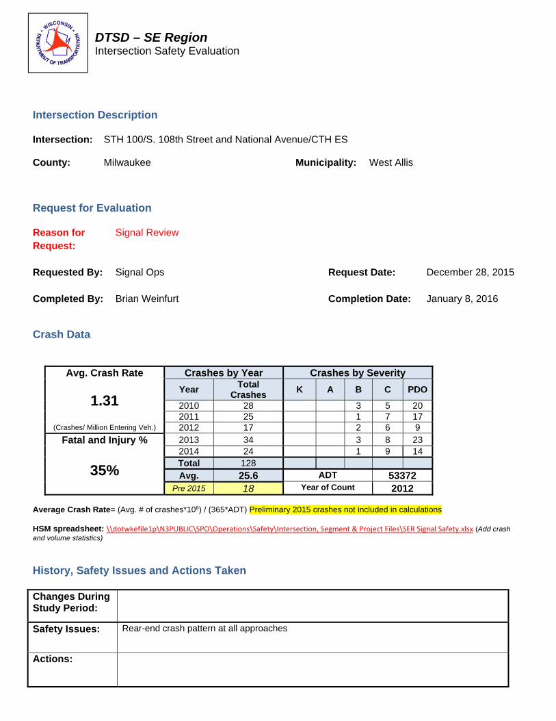
DTSD – SE Region Intersection Safety Evaluation
Intersection Description Intersection: STH 100/S. 108th Street and National Avenue/CTH ES
County: Milwaukee Municipality: West Allis
Request for Evaluation Reason for Request:
Signal Review
Requested By:
Signal Ops Request Date: December 28, 2015
Completed By: Brian Weinfurt Completion Date: January 8, 2016
Crash Data
Avg. Crash Rate Crashes by Year Crashes by Severity
1.31 Year
Total Crashes
K A B C PDO
2010 28 3 5 20 2011 25 1 7 17
(Crashes/ Million Entering Veh.) 2012 17 2 6 9
Fatal and Injury % 2013 34 3 8 23
35%
2014 24 1 9 14 Total 128 Avg. 25.6 ADT 53372
Pre 2015 18 Year of Count 2012 Average Crash Rate= (Avg. # of crashes*106) / (365*ADT) Preliminary 2015 crashes not included in calculations HSM spreadsheet: \\dotwkefile1p\N3PUBLIC\SPO\Operations\Safety\Intersection, Segment & Project Files\SER Signal Safety.xlsx (Add crash and volume statistics)
History, Safety Issues and Actions Taken Changes During Study Period:
Safety Issues: Rear-end crash pattern at all approaches
Actions:

DTSD – SE Region Intersection Safety Evaluation
STH 100/S. 108th Street and National Avenue/CTH ES
Milwaukee County 2010 to Pre-2015
LEGEND
Signal/Sign Post Bicycle Right Angle Out of Control (S) = SNOW-ICE K = FATAL
Tree/Utility Pole Pedestrian Left Turn Rear-End (W) = WET A = INCAPACITATING
Non-Fixed Object Non-Contact Vehicle Right Turn Head-On (F) = FOG-MIST B = NON-INCAP.
Fixed Object Backing Vehicle Sideswipe-Same Overtake (DUI) = ALCOHOL C = POS. INJURY
Parked Vehicle Moving Vehicle Sideswipe-Opp. Overturn OR DRUG USE BLANK = PDO
8/31/12 1/28/13, C 3/11/14, C, (W)
6/8/10, C, (W) 7/1/11 10/27/11 2/1/13 10/10/13 11/2/13
9/8/10 12/20/10 2/26/11, (W) 7/28/11, C 10/17/11 4/7/12, C 8/2/12, C 5/15/13, C 6/5/13, B, (W) 6/24/13 3/31/14 1/4/14 6/5/14 7/3/14, C 8/8/14 8/12/14, C 3/10/15
3/1/11
3/25/12 8/16/12, (W)
3/29/10 11/11/10, C 1/25/11, (W) 11/1/11 12/17/13, C, (W) 1/23/14 9/8/14 12/11/14 2/24/15 10/15/15
10/27/10, C 5/13/14, B 5/31/14 7/28/14 9/29/14, C 5/23/15
4/15/10 7/27/10 9/20/10 11/22/10, (W) 4/22/11, (W) 9/9/11, C 10/6/11, C 6/11/12 9/22/12, C, (W) 11/6/12, C, (W) 12/22/12, (W) 1/29/13, C (W) 5/19/13, C 6/27/13, (W) 7/27/13 9/23/13 11/13/13 12/18/14 1/31/15, C 4/20/15, (W) 7/25/15
4/27/12 10/1/13
6/24/11
2/24/10, C, (S) 10/5/10 3/11/12 4/17/13, (W) 6/22/13 5/5/15, (W)
3/6/10, B 9/7/10 3/7/12, C, (W) 11/16/12, B 1/30/14, C, (S)
3/28/10, B 5/8/10, C 5/6/10 5/9/14 6/12/15, C
5/24/10 11/15/11
6/10/10, B 2/12/11, (W) 8/12/13 3/16/14 2/21/15 10/10/15
3/3/11
7/9/11, B
11/4/11, C 9/25/12, C 10/13/12 11/11/12, B, (W) 11/17/13, B, (W) 4/24/14, C 6/13/14, C 1/31/15
2/4/10 2/9/10, (S) (2) 3/1/10 4/24/10, (W) 4/30/10 5/17/10 11/18/10 11/29/10, (W) 1/27/11, (S) 2/26/11, C, (S) 6/12/11, C 10/20/11, C, (W) 10/20/11 12/14/11, (W) 12/21/11, (W) 12/30/11, (W) 7/18/12 1/31/13, (W) 2/23/13, (W) 3/7/13 3/12/13 6/14/13, C 8/31/13 9/21/13 9/21/13 10/5/13, C 10/28/13, C 10/28/13 12/23/13 12/24/13, B, (W) 1/18/14, C, (W) 3/8/14, (W) 6/9/14, C 6/18/14 1/12/15, C 1/26/15 2/10/15 5/20/15, C 7/18/15 7/29/15
5/23/13. B
11/16/13, (W)


DTSD – SE Region Intersection Safety Evaluation
Intersection Description
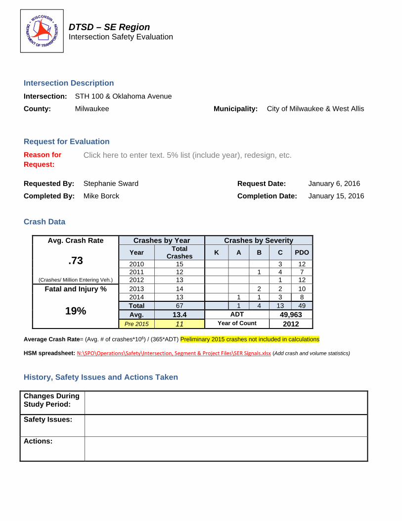
Intersection: STH 100 & Oklahoma Avenue
County: Milwaukee Municipality: City of Milwaukee & West Allis
Request for Evaluation
Reason for Request:
Click here to enter text. 5% list (include year), redesign, etc.
Requested By: Stephanie Sward Request Date: January 6, 2016
Completed By: Mike Borck Completion Date: January 15, 2016
Crash Data
Avg. Crash Rate Crashes by Year Crashes by Severity
.73 Year
Total Crashes
K A B C PDO
2010 15 3 12 2011 12 1 4 7
(Crashes/ Million Entering Veh.) 2012 13 1 12
Fatal and Injury % 2013 14 2 2 10
19%
2014 13 1 1 3 8 Total 67 1 4 13 49 Avg. 13.4 ADT 49,963
Pre 2015 11 Year of Count 2012 Average Crash Rate= (Avg. # of crashes*106) / (365*ADT) Preliminary 2015 crashes not included in calculations HSM spreadsheet: N:\SPO\Operations\Safety\Intersection, Segment & Project Files\SER Signals.xlsx (Add crash and volume statistics)
History, Safety Issues and Actions Taken Changes During Study Period:
Safety Issues:
Actions:

DTSD – SE Region Intersection Safety Evaluation
STH 100 & Oklahoma Avenue
Milwaukee County January 2010-Pre 2015
LEGEND
Signal/Sign Post Bicycle Right Angle Out of Control (S) = SNOW-ICE K = FATAL
Tree/Utility Pole Pedestrian Left Turn Rear-End (W) = WET
A = INCAPACITATING
Non-Fixed Object Non-Contact Vehicle Right Turn Head-On (F) = FOG-MIST
B = NON-INCAP.
Fixed Object Backing Vehicle Sideswipe-Same Overtake (DUI) = ALCOHOL
C = POS. INJURY
Parked Vehicle Moving Vehicle Sideswipe-Opp. Overturn OR DRUG USE
BLANK = PDO
1/7/2010, (S)
STH 100
1/7/2010, (S) 6/28/2011 7/9/2013, C 8/17/2013 3/4/2014, (S)
2/11/2010 12/20/10 12/6/2011 12/10/2012 12/17/2012 9/3/2013 12/11/2013, (W)
3/11/2010, C 5/31/2010 10/8/2010 6/9/2011, C 11/17/2011 3/4/2015
5/24/2010, C 6/6/2010, (W) 6/24/2010 6/26/2011, C 8/23/2011 9/13/2011, C 6/17/2012 9/2/2012 1/31/2012, (S) 3/19/2013 5/3/2013, (W) 7/16/2013 8/26/2013, B 6/5/2014, C 11/11/2014, (W) 3/19/2015 8/29/2015, (W)
9/16/2010
11/14/2010, (W)
12/11/2010, (W)
12/12/2010, (S) 10/23/2015, (W)
12/19/2010, C 2/21/2011, (S) 9/26/2011, (W) 12/14/2011, C, (W) 6/27/2012, C 10/4/2012 5/18/2013 11/26/2013, (W) 12/2/2013 1/25/2014, (S) 2/14/2014 5/14/2014, C 6/3/2014, A 8/21/2014, (W) 10/4/2014, C 101/10/2014 3/14/2015 4/16/2015, C 5/5/2015
2/5/2011, (W), B
4/5/2011
3/24/2012 10/22/2012 11/1/2012 2/26/2013
3/24/2012 7/22/2012 8/28/2013, B 1/14/2014, B
11/6/2012,
3/23/2013, C 1/25/2014
3/28/2014
5/2/2015, C
6/5/2015
7/16/2015, B, (W)
7/17/2015
Oklahoma Avenue