winchester-1 summary ep - nopsema · erp emergency response plan ... winchester-1 drill site, ......
TRANSCRIPT

WIN1-2000-SUM-0001 ‘uncontrolled when printed’
WINCHESTER-1 (WA-323-P) DRILLING PROGRAM
ENVIRONMENT PLAN SUMMARY
WIN1-2000-SUM-0001
Rev Date Reason for issue Author Checked Approved
0 22/03/2013 To NOPSEMA for public disclosure O Glade-Wright P Raitt A Gill

WIN1-2000-SUM-0001 ‘uncontrolled when printed’
TABLE OF CONTENTS
ABBREVIATIONS & ACRONYMS ................................................................................................. 1
1 INTRODUCTION ................................................................................................................... 2
2 PROJECT LOCATION .......................................................................................................... 2
3 DESCRIPTION OF THE ACTION .......................................................................................... 4
4 DESCRIPTION OF EXISTING ENVIRONMENT .................................................................... 5
4.1 Physical Environment ............................................................................................................................. 5
4.2 Biological Environment ........................................................................................................................... 5
4.3 Cultural Environment .............................................................................................................................. 7
4.4 Socio-economic Environment ................................................................................................................ 7
5 ENVIRONMENTAL HAZARDS AND CONTROLS ................................................................ 8
6 MANAGEMENT APPROACH.............................................................................................. 14
7 STAKEHOLDER CONSULTATION ..................................................................................... 14
8 CONTACT DETAILS ........................................................................................................... 15
9 REFERENCES .................................................................................................................... 16
LIST OF FIGURES
Figure 1 Winchester-1 location map ............................................................................................................... 3
LIST OF TABLES
Table 1 Distances to key features in the region .......................................................................................... 4
Table 2 Hazards and Controls ..................................................................................................................... 9

WIN1-2000-SUM-0001 ‘uncontrolled when printed’ Page 1 of 16
ABBREVIATIONS & ACRONYMS
AHTS Anchor Handling and Tug Vessel
ALARP As Low As Reasonably Practicable
AMSA Australian Maritime Safety Authority (Cth)
APASA Asia-Pacific Applied Science Associates
APPEA Australian Petroleum Production and Exploration Association
AQIS Australian Quarantine Inspection Service (Cth)
AS Australian Standard
BOP Blowout Preventer
CAMBA China-Australia Migratory Birds Agreement 1974
DEC Department of Environment and Conservation (WA)
DEWHA Department of Environment, Water, Heritage and the Arts (Cth)
DoF Department of Fisheries (WA)
DSEWPC Department of Sustainability, Environment, Water, Population and Communities (Cth)
EHS Environment Health & Safety
EHSMS Environment Health & Safety Management System
EP Environment Plan
EPBC Act Environment Protection and Biodiversity Conservation Act 1999
ERP Emergency Response Plan
FPSO Floating Production Storage and Offloading Unit
GDA Geodetic Datum of Australia
HTHP High Temperature-High Pressure
IAPP International Air Pollution Prevention
ISO International Standards Organisation
JAMBA Japan-Australia Migratory Birds Agreement 1974
MARPOL International Convention for the Prevention of Pollution from Ships
MODU Mobile Offshore Drilling Unit
MSDS Material Safety Data Sheet
NOPSEMA National Offshore Petroleum Safety and Environmental Management Authority
NWS North West Shelf
OPGGS Offshore Petroleum and Greenhouse Gas Storage
OSCP Oil Spill Contingency Plan
OWS Oily Water Separator
PMP Preventative Maintenance Program
PSZ Petroleum Safety Zone
ROC Retention on Cuttings
ROV Remotely Operated Vehicle
SBM Synthetic-Based Mud
SOPEP Ship Oil Pollution Emergency Plan
STP Sewage Treatment Plant
VSP Vertical Seismic Profiling
WA Western Australia

WIN1-2000-SUM-0001 ‘uncontrolled when printed’ Page 2 of 16
1 INTRODUCTION
Santos Offshore Pty Ltd (Santos), a fully owned subsidiary of Santos Ltd, is proposing to drill
the Winchester-1 gas exploration well located in exploration permit WA-323-P on Western
Australia’s North West Shelf (NWS), approximately 135 km northwest of Dampier (Figure 1).
Santos is the nominated operator of the permit (75% interest) on behalf of its Joint Venture
Partner, Octanex N.L. (as Winchester Resources N.L.) who has the remaining 25% interest.
The drilling of this well follows the success of the Winchester 3D Seismic Survey undertaken in
October 2011.
The drilling will be conducted in accordance with all applicable legislation and regulations and
specifically to meet the requirements of the Offshore Petroleum and Greenhouse Gas Storage
Act 2006 and its regulations.
In accordance with Regulation 4(1) of the Offshore Petroleum and Greenhouse Gas Storage
(Environment) Regulations 2009 (OPGGS (Environment) Regulations), the Environment Plan
(EP) applies to a defined “Petroleum activity”. For the Winchester-1 drilling program this is
defined as:
From the time that the MODU initiates jack-up at location of the well in permit area
WA-323-P until completion of the proposed drilling and demobilisation from the
well location.
2 Project Location
The proposed Winchester-1 well is located in a water depth of approximately 80 m at (GDA 94,
AMG Zone 50):
Degrees UTM
20° 00’ 37.81” S latitude 7,786,780 N
115° 38’ 29.291” E longitude 357,890 E
The location of the proposed well is shown in Figure 1. Distances from the proposed
Winchester-1 drill site to key features in the region are listed in Table 1.

WINCHESTER-1 ENVIRONMENT PLAN
WIN1-2000-SUM-0001 ‘uncontrolled when printed’ Page 3 of 16
Figure 1 Winchester-1 location map

WINCHESTER-1 ENVIRONMENT PLAN
WIN1-2000-SUM-0001 ‘uncontrolled when printed’ Page 4 of 16
Table 1 Distances to key features in the region
Locality Distance
Environmental features
Montebello Islands (nearest island) 41 km to the south
Varanus Island 71 km to the south
Barrow Island 76 km to the south-southwest
Dampier Archipelago 107 km to the southeast
Marine conservation parks (closest boundary)
Montebello Islands Marine Park (WA) 35 km to the south
Barrow Island Marine Management Area (WA) 60 km to the south
Muiron Islands Marine Management Area (WA) 218 km southwest
Ningaloo Marine Park (Commonwealth and WA waters) 237 km southwest
Coastal towns
Dampier 135 km to the southeast
Karratha 149 km to the southeast
Onslow 189 km south-southwest
Exmouth 266 km to the southwest
3 Description of the Action
Santos has contracted the Ensco 109 jack-up Mobile Offshore Drilling Unit (MODU) to drill the
Winchester-1 well.
One or more AHTS (Anchor Handling, Tug and Supply) vessels will tow the MODU to the
Winchester-1 drill site, where it will mechanically jack down its’ legs to the seabed, raising its hull
clear of the water (by about 15m) in order to drill. Personnel will access the MODU via helicopter
that will be based in Karratha.
The MODU will be primarily supported by two AHTS vessels for the duration of the drilling
campaign. The support vessels will fulfil the following functions:
• Tow the rig to and from location;
• Supply fresh water, food, fuel, and bulk drilling fluid materials and drilling equipment;
• Monitor the petroleum safety zone around the MODU and intercept errant vessels; and
• Assist in emergency response functions.

WINCHESTER-1 ENVIRONMENT PLAN
WIN1-2000-SUM-0001 ‘uncontrolled when printed’ Page 5 of 16
Drilling will commence in early April and is expected to take approximately 80 days. Well
evaluation, including vertical seismic profiling (VSP) and wireline logging will be undertaken, prior
to the well being plugged and abandoned.
4 Description of Existing Environment
The physical, biological and socio-economic environment in and around the project area and the
Northwest Shelf (NWS) region in general are described in the following sections.
4.1 Physical Environment
The proposed Winchester-1 project area lies within the NWS Bioregion and occurs entirely on the
continental shelf. The physical environment of the area is summarised as:
• Sea surface temperatures vary seasonally within the monthly-averaged limits of 24°C
(winter and early spring) to 27°C (summer) (APASA 2012).
• Annual rainfall is typically low and highly variable, with most rainfall occurring during the
summer period (the wet season, January to July), usually associated with either monsoonal
thunderstorms or tropical cyclones.
• The winter wind (June-August) condition is characterised by moderate to strong east-
northeast to southeast winds. April-May and September are the transitional periods when
winds are lighter and more variable.
• Ocean currents on the NWS are dominated by the southward-flowing warm surface
Indonesian Throughflow, which flows from the tropics to the waters of southwest Western
Australia.
4.2 Biological Environment
Benthic Environment
Given the depth of water and nature of the seabed, few significant benthic resources are expected
to be located in the project area.
The depth of water limits the occurrence of most algae, seagrass, corals and some fish and reptile
species, while the absence of hard substrates prevents coralline red algae and many forms of
sessile fauna from colonising the seabed. Sandy substrates of the NWS support a low density of
benthic communities of bryozoans, molluscs and echinoids, with sponge communities found only in
areas containing hard substrates (DEWHA, 2008).
Pelagic Environment
The NWS supports a diverse assemblage of fish, particularly in shallow water near the mainland
and around islands. Most fish have tropical distributions and are well distributed throughout the
Indo-West Pacific region.

WINCHESTER-1 ENVIRONMENT PLAN
WIN1-2000-SUM-0001 ‘uncontrolled when printed’ Page 6 of 16
Five species of marine turtles may occur within the project area according to the EPBC Act
Protected Matters Search Tool (PMST). Four of these species, the green, hawksbill, flatback, and
loggerhead turtles (from the family Cheloniidae) are known to have major breeding rookeries along
the Pilbara coast.
The Dampier Archipelago, the Montebello Island group and the Lowendal Islands have been
identified as regionally significant rookeries for the hawksbill, green and flatback turtles and to a
lesser extent the loggerhead turtle. The green turtle is common around Barrow Island, while
identified rookeries for the flatback turtle include Barrow Island and more north-easterly beaches
including those at Cape Thouin (Prince, 1993; 1994; Pendoley, 1997).
According to the EPBC Act PMST, 11 whale and dolphin species (cetaceans) may use the habitat
within a 5 km radius of the project area, some being seasonal visitors while others occur at low
densities all year round. Of these species, two are listed threatened; the humpback and blue
whales.
The humpback whale (Megaptera novaeangliae) is the most commonly sighted whale in the region
and is listed as a vulnerable and migratory species under the EPBC Act 1999. Humpback whales
migrate annually from their warm water breeding areas around the Kimberley coast of Western
Australia (between 15-20˚ latitude) to their summer colder feeding waters (Antarctic), south of 56˚S
latitude (Bannister et al., 1996; Jenner et al., 2001). Humpback whales are not known to feed while
in the region (DSEWPC, 2011).
The peak migratory periods for humpback whales around the Dampier Archipelago are July and
August for the northbound leg and August/September for the southbound leg (outside the drilling
period of April – June). The migratory path is the continental shelf of Australia (Jenner et al., 2001).
The project area is located on the estimated northern edge of the northern and southern migration
paths.
Blue whales (Balaenoptera musculus) have widespread migration patterns that are not known to
follow particular coastlines or oceanographic features (Bannister et al., 1996). They are an oceanic
species that migrate between warm water breeding grounds and cold water feeding grounds
(between 20 and 70˚S latitude in the southern hemisphere). The project area does not include any
known blue whale feeding, breeding or resting areas and there is no literature indicating sightings
of blue whales around the project area.
Thirteen species of sea snakes may occur in and around the project area according to the EPBC
Act PMST. None of these species are listed as threatened and they are generally widespread
throughout the waters of the NWS in offshore and near-shore habitats.
Seabirds and shorebirds may transit the area on occasion but the deep waters and distance to
emergent land make it unlikely that the project area comprises important habitat to birds.

WINCHESTER-1 ENVIRONMENT PLAN
WIN1-2000-SUM-0001 ‘uncontrolled when printed’ Page 7 of 16
One threatened seabird species is listed as likely to occur in and around the project area according
to the EPBC Act PMST, this being the southern giant-petrel (Macronectes giganteus), which is a
migratory species listed as endangered under the EPBC Act 1999.
Many migratory shorebirds that occur in the region are trans-equatorial. Some of these are
protected with agreements between Australia and Japan (JAMBA) and Australia and China
(CAMBA). A total of 47 bird species protected by these agreements have been reported in the
NWS. However, many species are unlikely to occur as far out to sea as the Winchester-1 project
area.
4.3 Cultural Environment
The water depth of the project area means it is highly unlikely that Aboriginal or non-Aboriginal
archaeological sites (i.e., evidence of past occupation) occur. The National Heritage List, which
includes Indigenous places of outstanding heritage value, does not list any sites in or around the
project area.
The Australian National Shipwreck Database (DSEWPC, 2012) lists 51 shipwrecks registered as
occurring within the Dampier region but none within the project area. The Western Australian
Shipwrecks Database (WA Museum, 2012) also indicates that there are no listed shipwrecks in the
project area and a detailed site survey commissioned as part of this campaign has confirmed that
the project area is free of wrecks.
4.4 Socio-economic Environment
Fisheries
The project area is in the vicinity of the following Commonwealth and State managed fisheries:
• North West Slope Trawl;
• Western Tuna and Billfish;
• Western Skipjack Tuna;
• Southern Bluefin Tuna;
• Pilbara Trap Managed Fishery;
• Onslow Prawn Managed Fishery; and
• Mackerel Managed Fishery.
In addition, commercial pearling occurs in areas of the NWS and there are leases within the
Montebello Islands Marine Management Area.
Petroleum Exploration and Production
The NWS is Australia’s most prolific oil and gas production area, largely responsible for Western
Australia accounting for 77% of the country’s oil and condensate production and 55% of the
country’s gas production in 2010 (APPEA, 2011). The Echo/Yodel development is the closest

WINCHESTER-1 ENVIRONMENT PLAN
WIN1-2000-SUM-0001 ‘uncontrolled when printed’ Page 8 of 16
petroleum production infrastructure to the proposed Winchester-1 well (located about 30 km to the
north-northeast).
Shipping
The ports of northwest Australia (Onslow, Dampier, Cape Lambert, Port Hedland and Broome)
handle large tonnages of iron ore and petroleum exports, resulting in very busy shipping routes
through the area.
The Maritime Standards Division of AMSA has informed Santos that the location of the Winchester-
1 project area is approximately 5nm west of the Dampier Shipping Fairway. Significant vessel
traffic uses this fairway travelling to or from the Port of Dampier, however the traffic is concentrated
in this area and Project activities are not anticipated to impact on the traffic using the fairway.
Recreational Fishing and Tourism
Recreational fisheries are managed by DoF. The DoF (2011) states that recreational fishing occurs
mostly in State waters adjacent to populated coastal areas. The DEC (2007) reports that the areas
of highest recreational fishing activity in the Montebello/Barrow Island Marine Conservation
Reserves are off the north-eastern end of Trimouille Island and in the waters south of the
Montebello group.
Commonwealth Marine Reserves
Winchester-1 is located within the northeast corner of the newly established Montebello
Commonwealth Marine Reserve. The reserve covers an area of 3,413 m2 and has the following
conservation values:
• Foraging areas adjacent to important breeding areas for migratory seabirds.
• Foraging areas for vulnerable and migratory whale shark.
• Foraging areas and adjacent to important nesting sites for marine turtles.
• Includes part of the migratory pathway of the protected humpback whale.
• Examples of seafloor habitats and communities of the NWS Province provincial bioregions
as well as the Pilbara (Offshore) meso-scale bioregion.
• Contains an ancient coastline (a unique seafloor feature that provides areas of enhanced
biological productivity).
The Multiple Use zoning scheme for the Montebello Commonwealth Marine Reserve allows for
mining (including exploration, development and other activities), with mining considered to include
oil and gas exploration and production. This means that drilling is an allowable activity under the
zoning scheme when it is undertaken in accordance with relevant legislation.
5 Environmental Hazards and Controls
Environmental risk assessment refers to a process where hazards associated with an activity are
assessed for their impact on the environment (physical, biological, and socio-economic) at a

WINCHESTER-1 ENVIRONMENT PLAN
WIN1-2000-SUM-0001 ‘uncontrolled when printed’ Page 9 of 16
defined location and specified period of time. Regulations 13(3) and 13(3A) in the OPGGS
(Environment) Regulations require that the environmental impacts and risks must be included in an
EP and evaluated.
The environmental risk assessment process applied to the Winchester-1 campaign is based on the
Santos EHS Management Standard 09 “Hazard Identification, Risk Assessment and Control”,
which describes the Santos standard and process with respect to risk assessment for all Santos
activities. The methodology described in EHSMS09 is based upon the risk management process
described in AS/NZ ISO 31000. The following table summarises the key environmental hazards
and their associated controls.
Table 2 Hazards and Controls
Environmental Hazard Controls
Physical Presence
Seabed disturbance
• AHTS vessels will not use anchors but thrusters to maintain location.
• A MODU move/positioning procedure will be in place and complied with.
• Materials handling and transfer procedures in place to minimise the risk of dropped objects.
• Post-drilling ROV survey will be conducted to identify dropped objects for retrieval.
Underwater Noise • VSP will comply with the DSEWPC EPBC Act Policy Statement 2.1 (2008) Part A.
• VSP will only last for several hours.
• The Australian Guidelines for Whale and Dolphin Watching (2005) for sea-faring activities
will be implemented for the AHTS vessels. Management, as related to noise includes:
o Caution zone (300 m either side of whales and 150 m either side of dolphins)
– vessels must operate at no wake speed in this zone.
o No approach zone (100 m either side of whales and 50 m either side of
dolphins) – vessels should not enter this zone and should not wait in front of
the direction of travel or an animal or pod.
• Cetacean observations will be recorded on DSEWPC cetacean sighting proformas and
returned to DSEWPC.
Light Emissions • Flaring will not be undertaken.
• Minimal lighting will be pointed down towards the water.
• Vessel lighting will be managed in accordance with maritime safety standards.
Collisions with
Cetaceans
• The Australian Guidelines for Whale and Dolphin Watching (2005) for sea-faring activities
will be implemented:
o Caution zone (300 m either side of whales and 150 m either side of dolphins)
– vessels must operate at no wake speed in this zone.
o No approach zone (100 m either side of whales and 50 m either side of
dolphins) – vessels should not enter this zone and should not wait in front of
the direction of travel or an animal or pod.
• Cetacean observations will be recorded on DSEWPC cetacean sighting proformas and
returned to DSEWPC.
WINCHESTER-1 ENVIRONMENT PLAN
WIN1-2000-SUM-0001 ‘uncontrolled when printed’ Page 10 of 16
Environmental Hazard Controls
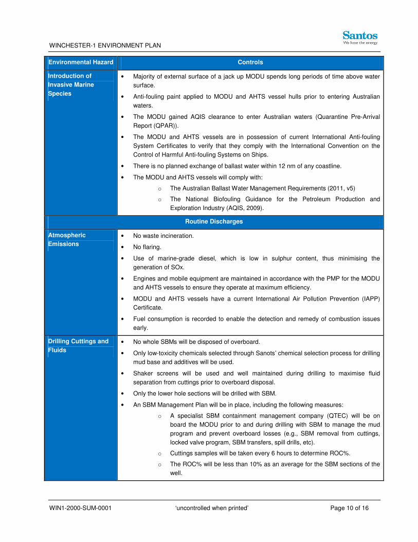
Introduction of
Invasive Marine
Species
• Majority of external surface of a jack up MODU spends long periods of time above water
surface.
• Anti-fouling paint applied to MODU and AHTS vessel hulls prior to entering Australian
waters.
• The MODU gained AQIS clearance to enter Australian waters (Quarantine Pre-Arrival
Report (QPAR)).
• The MODU and AHTS vessels are in possession of current International Anti-fouling
System Certificates to verify that they comply with the International Convention on the
Control of Harmful Anti-fouling Systems on Ships.
• There is no planned exchange of ballast water within 12 nm of any coastline.
• The MODU and AHTS vessels will comply with:
o The Australian Ballast Water Management Requirements (2011, v5)
o The National Biofouling Guidance for the Petroleum Production and
Exploration Industry (AQIS, 2009).
Routine Discharges
Atmospheric
Emissions
• No waste incineration.
• No flaring.
• Use of marine-grade diesel, which is low in sulphur content, thus minimising the
generation of SOx.
• Engines and mobile equipment are maintained in accordance with the PMP for the MODU
and AHTS vessels to ensure they operate at maximum efficiency.
• MODU and AHTS vessels have a current International Air Pollution Prevention (IAPP)
Certificate.
• Fuel consumption is recorded to enable the detection and remedy of combustion issues
early.
Drilling Cuttings and
Fluids
• No whole SBMs will be disposed of overboard.
• Only low-toxicity chemicals selected through Sanots’ chemical selection process for drilling
mud base and additives will be used.
• Shaker screens will be used and well maintained during drilling to maximise fluid
separation from cuttings prior to overboard disposal.
• Only the lower hole sections will be drilled with SBM.
• An SBM Management Plan will be in place, including the following measures:
o A specialist SBM containment management company (QTEC) will be on
board the MODU prior to and during drilling with SBM to manage the mud
program and prevent overboard losses (e.g., SBM removal from cuttings,
locked valve program, SBM transfers, spill drills, etc).
o Cuttings samples will be taken every 6 hours to determine ROC%.
o The ROC% will be less than 10% as an average for the SBM sections of the
well.

WINCHESTER-1 ENVIRONMENT PLAN
WIN1-2000-SUM-0001 ‘uncontrolled when printed’ Page 11 of 16
Environmental Hazard Controls
Cement • No bulk batch discharge of mixed cement will take place.
• Only the required volume of cement is mixed during each cement operation in accordance
with the cementing program. During conductor cementing operations, further mixing of
cement is ceased once cement returns are noted at the seabed through ROV inspection.
• The volume of cement mixed will be accurately calculated to ensure only that which is
necessary for drilling is mixed to minimise volume to be disposed.
Cooling Water • Cooling water is released at height to facilitate oxygenation and cooling.
• The open-loop cooling water system is segregated from contact with hydrocarbons to limit
potential cross-contamination of discharge streams.
Desalination Brine
Water
• Brine water is released at height to facilitate oxygenation and cooling.
• Reverse osmosis plant is maintained in accordance with the preventative maintenance
program (PMP) so that it is running within the expected operational range.
Sewage and Grey
Water
• MARPOL-approved sewage treatment plant (STP) fitted to MODU and AHTS vessels.
• MODU and AHTS vessels will have in place valid Statement of Compliance for Sewage
Pollution Prevention certificates.
• STP maintained in accordance with the PMP.
Putrescible Waste • Galley macerator in place on MODU and support vessels.
• The galley macerator will macerate food scraps to a diameter of less than 25 mm before
being disposed of overboard, in compliance with MARPOL Annexes IV and V.
• Putrescible food waste is managed under Ensco’s Asia and Pacific Rim Business Unit
Environmental Plan (GU-APR-SHE-022, 2009) and the Waste Management Procedure
(PR-APR-EXEC-002, 2005).
• The macerator is maintained in accordance with the PMP (or replaced when blades are
blunt or the motor is non-functional).
Deck Drainage and
Bilge Water
• Deck coaming/kick-plating in place.
• Equipment, hydrocarbon and chemical storage areas are bunded (e.g., engine room,
refuelling area, sack room).
• Drains routed to oily waste tank.
• Bilges drain via an oily water separator (OWS) set to prevent discharge of water greater
than 15 ppm.
• The MODU and AHTS vessels have current and valid International Oil Pollution
Prevention Certificates.
• Any temporary equipment with the potential for spill of chemicals or fuels will be located
within temporary bunding so that spills are contained for subsequent treatment or disposal
of the fluids.
• Chemicals are stored in bunded areas.
• Deck drainage and the OWS is managed under Ensco’s Asia and Pacific Rim Business
Unit Environmental Plan (GU-APR-SHE-022, 2009).
• SOPEP kits will be stored in various locations around the vessel and will be maintained
WINCHESTER-1 ENVIRONMENT PLAN
WIN1-2000-SUM-0001 ‘uncontrolled when printed’ Page 12 of 16
Environmental Hazard Controls
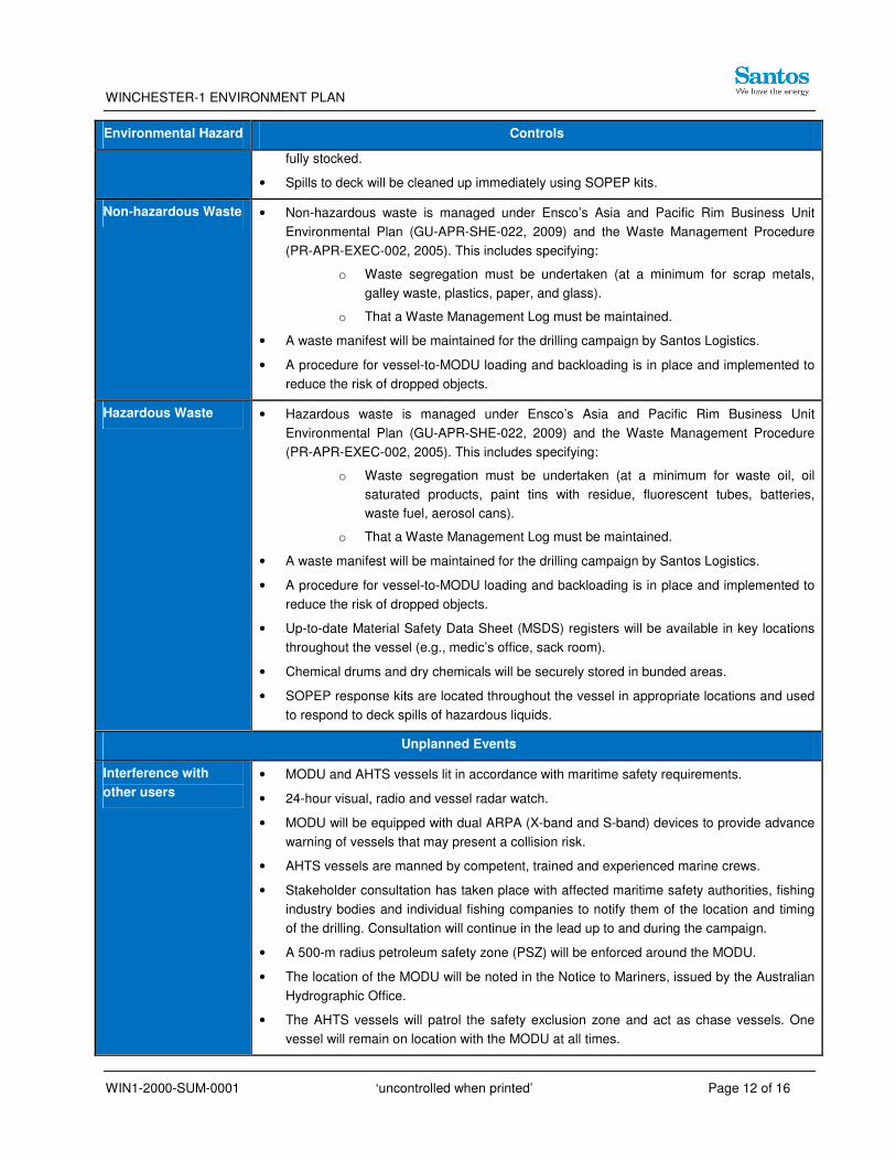
fully stocked.
• Spills to deck will be cleaned up immediately using SOPEP kits.
Non-hazardous Waste • Non-hazardous waste is managed under Ensco’s Asia and Pacific Rim Business Unit
Environmental Plan (GU-APR-SHE-022, 2009) and the Waste Management Procedure
(PR-APR-EXEC-002, 2005). This includes specifying:
o Waste segregation must be undertaken (at a minimum for scrap metals,
galley waste, plastics, paper, and glass).
o That a Waste Management Log must be maintained.
• A waste manifest will be maintained for the drilling campaign by Santos Logistics.
• A procedure for vessel-to-MODU loading and backloading is in place and implemented to
reduce the risk of dropped objects.
Hazardous Waste • Hazardous waste is managed under Ensco’s Asia and Pacific Rim Business Unit
Environmental Plan (GU-APR-SHE-022, 2009) and the Waste Management Procedure
(PR-APR-EXEC-002, 2005). This includes specifying:
o Waste segregation must be undertaken (at a minimum for waste oil, oil
saturated products, paint tins with residue, fluorescent tubes, batteries,
waste fuel, aerosol cans).
o That a Waste Management Log must be maintained.
• A waste manifest will be maintained for the drilling campaign by Santos Logistics.
• A procedure for vessel-to-MODU loading and backloading is in place and implemented to
reduce the risk of dropped objects.
• Up-to-date Material Safety Data Sheet (MSDS) registers will be available in key locations
throughout the vessel (e.g., medic’s office, sack room).
• Chemical drums and dry chemicals will be securely stored in bunded areas.
• SOPEP response kits are located throughout the vessel in appropriate locations and used
to respond to deck spills of hazardous liquids.
Unplanned Events
Interference with
other users
• MODU and AHTS vessels lit in accordance with maritime safety requirements.
• 24-hour visual, radio and vessel radar watch.
• MODU will be equipped with dual ARPA (X-band and S-band) devices to provide advance
warning of vessels that may present a collision risk.
• AHTS vessels are manned by competent, trained and experienced marine crews.
• Stakeholder consultation has taken place with affected maritime safety authorities, fishing
industry bodies and individual fishing companies to notify them of the location and timing
of the drilling. Consultation will continue in the lead up to and during the campaign.
• A 500-m radius petroleum safety zone (PSZ) will be enforced around the MODU.
• The location of the MODU will be noted in the Notice to Mariners, issued by the Australian
Hydrographic Office.
• The AHTS vessels will patrol the safety exclusion zone and act as chase vessels. One
vessel will remain on location with the MODU at all times.
WINCHESTER-1 ENVIRONMENT PLAN
WIN1-2000-SUM-0001 ‘uncontrolled when printed’ Page 13 of 16
Environmental Hazard Controls
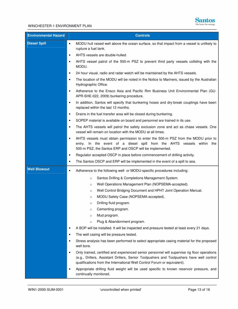
Diesel Spill • MODU hull raised well above the ocean surface, so that impact from a vessel is unlikely to
rupture a fuel tank.
• AHTS vessels are double-hulled.
• AHTS vessel patrol of the 500-m PSZ to prevent third party vessels colliding with the
MODU.
• 24 hour visual, radio and radar watch will be maintained by the AHTS vessels.
• The location of the MODU will be noted in the Notice to Mariners, issued by the Australian
Hydrographic Office.
• Adherence to the Ensco Asia and Pacific Rim Business Unit Environmental Plan (GU-
APR-SHE-022, 2009) bunkering procedure.
• In addition, Santos will specify that bunkering hoses and dry-break couplings have been
replaced within the last 12 months.
• Drains in the fuel transfer area will be closed during bunkering.
• SOPEP material is available on board and personnel are trained in its use.
• The AHTS vessels will patrol the safety exclusion zone and act as chase vessels. One
vessel will remain on location with the MODU at all times.
• AHTS vessels must obtain permission to enter the 500-m PSZ from the MODU prior to
entry. In the event of a diesel spill from the AHTS vessels within the
500-m PSZ, the Santos ERP and OSCP will be implemented.
• Regulator accepted OSCP in place before commencement of drilling activity.
• The Santos OSCP and ERP will be implemented in the event of a spill to sea.
Well Blowout • Adherence to the following well- or MODU-specific procedures including:
o Santos Drilling & Completions Management System.
o Well Operations Management Plan (NOPSEMA-accepted).
o Well Control Bridging Document and HPHT Joint Operation Manual.
o MODU Safety Case (NOPSEMA-accepted).
o Drilling fluid program.
o Cementing program.
o Mud program.
o Plug & Abandonment program.
• A BOP will be installed. It will be inspected and pressure tested at least every 21 days.
• The well casing will be pressure tested.
• Stress analysis has been performed to select appropriate casing material for the proposed
well bore.
• Only trained, certified and experienced senior personnel will supervise rig floor operations
(e.g., Drillers, Assistant Drillers, Senior Toolpushers and Toolpushers have well control
qualifications from the International Well Control Forum or equivalent).
• Appropriate drilling fluid weight will be used specific to known reservoir pressure, and
continually monitored.

WINCHESTER-1 ENVIRONMENT PLAN
WIN1-2000-SUM-0001 ‘uncontrolled when printed’ Page 14 of 16
Environmental Hazard Controls
• Well control training and drill ‘kick’ response training is undertaken by relevant drill crew in
line with the Ensco training matrix prior to entering the reservoir.
• Regulator accepted OSCP in place before commencement of drilling activity.
• The Santos OSCP, ERP and Well Kill Plan will be implemented immediately in the unlikely
event of a blowout.
6 Management Approach
The Winchester-1 campaign will be managed in compliance with the EP accepted by NOPSEMA in
accordance with the OPGGS (Environment) Regulations.
The objective of the EP is to ensure that the potential adverse impacts on the environment
associated with the activity during both routine and non-routine operations are identified, will be
reduced to ALARP and will be of an acceptable level. This includes the definition of risk controls
that are in place to manage each of the identified risks.
The EP defines environmental performance objectives and environmental performance standards
that are used as a basis for managing environmental risks identified through the risk assessment
process. Specific measurement criteria have been determined which are used to demonstrate that
these performance objectives and standards are achieved.
An implementation strategy is described within the EP. The implementation strategy provides a
summary of the Santos systems, practices and procedures in place to manage the environmental
risk associated with its activities to ALARP. It also sets out strategies to ensure that the specific
environmental objectives and standards for Winchester-1 drilling as outlined in the EP are
established and monitored, in accordance with Regulation 14 of the OPGGS (Environment)
Regulations.
7 Stakeholder Consultation
Santos has been actively involved in stakeholder engagement for NWS activities since the
development of its Mutineer Exeter FPSO production facility in 2005. The Mutineer Exeter
development initiated the long-term relationship between Santos and relevant stakeholders such as
commercial and recreational fisheries, conservation organisations, recreational organisations, non-
government organisations and government agencies.
Santos EHSMS07 (Consultation and Communication) was used to develop the stakeholder
consultation strategy. The Santos guideline defines a stakeholder as:
Any affected persons, interested persons or organisations that are impacted by, or can
impact a project.

WINCHESTER-1 ENVIRONMENT PLAN
WIN1-2000-SUM-0001 ‘uncontrolled when printed’ Page 15 of 16
Stakeholder identification for the Winchester-1 drilling program builds on that undertaken for recent
Santos activities in the region (e.g., Winchester seismic survey, Fletcher-Finucane development)
as well as recent activities undertaken by operators on Santos’ behalf (Winchester-1 site survey
undertaken by Fugro).
All identified stakeholders were sent information flyers and/or consulted (emails, phone calls,
meetings) as part of the EP process. Stakeholders included:
• Federal government regulatory/referral authorities;
• State government regulatory/referral authorities;
• Commercial fisheries and representatives;
• Conservation agencies;
• Industry stakeholders; and
• Oil spill response support agencies.
8 Contact Details
The Santos environmental contact for this drilling activity is;
Petrina Raitt
Senior Environmental Advisor
Phone: 08-9363 9062
Mobile: 0458 887 791
Email: [email protected]
Additional information regarding Santos can be obtained from its website at: www.santos.com

WINCHESTER-1 ENVIRONMENT PLAN
WIN1-2000-SUM-0001 ‘uncontrolled when printed’ Page 16 of 16
9 References
APASA. 2012. Quantitative oil spill modelling study for Winchester-1 exploration well, Carnarvon
Basin. Prepared for Santos Ltd and Aventus Consulting by Asia-Pacific ASA Pty Ltd.
APPEA. 2011. Key Statistics 2011. Australian Petroleum Production and Exploration Association.
Canberra.
Bannister, J.L., Kemper, C.M. and Warneke, R.M. 1996. The Action Plan for Australian Cetaceans.
Australian Nature Conservation Agency.
BBG. 2001. Environmental Review Norfolk Well Area. Unpublished report prepared for Ecos
Consulting (Aust) by Bowman Bishaw Gorham.
DEC 2007. Management Plan for the Montebello/Barrow Islands Marine Conservation Reserves
2007 – 2017. Management Plan No. 55. Department of Environment and Conservation.
DEWHA. 2008. The North-West Marine Bioregional Plan: Bioregional Profile. Department of
Environment, Water, Heritage and the Arts. Canberra.
DoF. 2011. State of the Fisheries and Aquatic Resources Report 2010/11. A WWW document
accessed in 2012 at http://www.fish.wa.gov.au/docs/sof/
index.php?0206. Department of Fisheries. Perth.
DSEWPC. 2011. Species Report Card – Cetaceans. Supporting the draft Marine Bioregional Plan
for the North-west Marine Region. Department of Sustainability, Environment, Water, Population
and Communities. Canberra.
DSEWPC. 2012. The Australian National Shipwreck Database. A WWW database accessed in
2012 at http://www.environment.gov.au/heritage/shipwrecks/
protected-zones.html. Department of Sustainability, Environment, Water, Population and
Communities. Canberra.
Jenner, K.C.S., Jenner, M-N.M, and McCabe, K.A. 2001. Geographical and Temporal Movements
of Humpback Whales in Western Australian Waters. In APPEA Journal 2001 (41):749-765.
Pendoley, K. 1997. Sea Turtles and Management of Marine Seismic Programs Western Australia.
PESA Journal 1997. No. 25. pp 8-15.
Prince, R. I. T. 1993. Western Australian Marine Turtle Conservation Project: An Outline of Scope
and an Invitation to Participate. In Marine Turtle Newsletter. No. 60. pp 8-14.
Prince, R. I. T. 1994. The Flatback Turtle (Natator depressus) in Western Australia: New
Information from the Western Australian Marine Turtle Project. From Proceedings of the
Australian Marine Turtle Conservation Workshop. Sea World Nara Resort, Gold Coast.
November 1990.