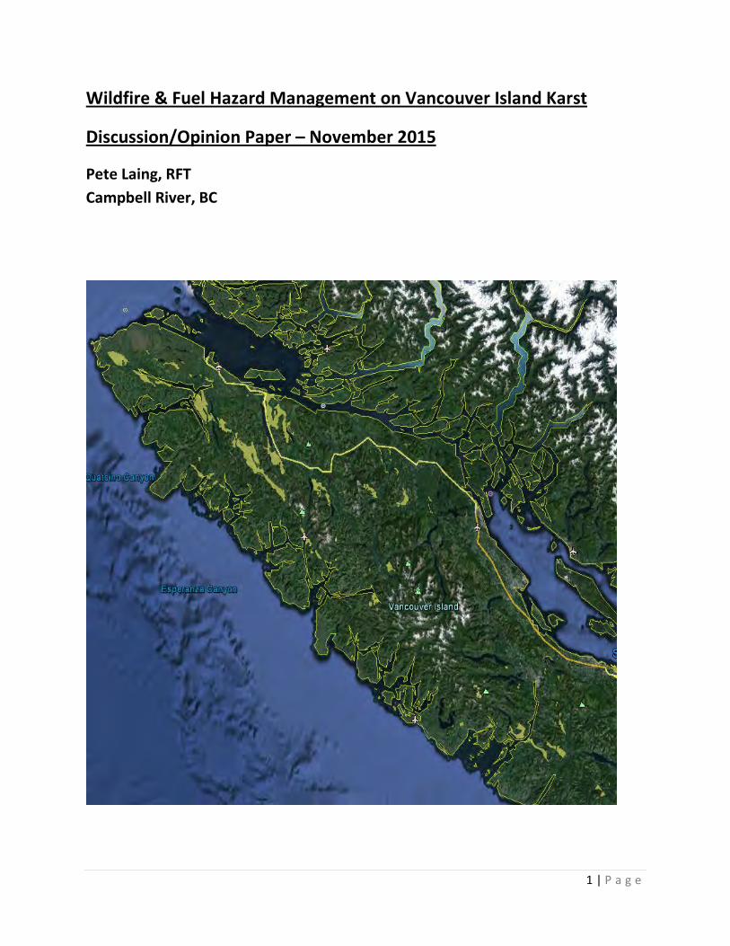
wildfire & fuel hazard management on vancouver island ... · pdf file1 | page wildfire...
TRANSCRIPT
1 | P a g e
Wildfire & Fuel Hazard Management on Vancouver Island Karst
Discussion/Opinion Paper – November 2015
Pete Laing, RFT Campbell River, BC
2 | P a g e
Preface
The intent of the paper is to examine wildfire and fuel hazard management on karst, specifically on Vancouver Island, with focus towards the north island. Most karst on Vancouver Island is sensitive to surface fire when compared to karst in other regions of BC, due to thin organic soil layers. Currently there is limited guidance specifically related to karst and fire, whether it is wild or prescribed. The best management practice (BMP) guidance that does exist may need to be examined for effectiveness. For all intensive purpose this is primarily a discussion paper, designed to raise situational awareness. This paper is forward looking, while using past situational examples to illustrate what we are learning; and to identify areas where consideration or improvements may exist.
There has been a great deal of research completed on karst globally and a limited amount in coastal areas of the Pacific Northwest. Although much is understood about the geomorphology and ‘mechanics’ of how karst systems work, much more research is required before a complete understanding of how a fire disturbance may impact any given karst system and associated ecosystems. The paper therefore uses broadly accepted science and anecdotal observations to form the terms of reference; while understanding that specific cause and effect circumstances associated with fire on karst and the associated ecosystems may be some time away. This should not be a barrier to developing best practice techniques that exceed those currently being used based on a growing body of knowledge and observed landscape changes. This paper does not attempt to describe karst in anything but the broadest of terms. Karst is complicated. Rudimentary reference materials are included at the end of the paper for those wanting to gain a deeper understanding of karst systems and their management in British Columbia.
This paper represents the opinion of the author alone.

3 | P a g e
Table of Contents
1. Terms of Reference page 5
2. Overview page 6
3. Karst and Fire Overview page 7
What is karst? page 7
What is Epikarst? page 7
Karst, Forestry and Fire page 8
Photos of fires on karst and non-karst terrain page 10
4. Karst and Fire Management page 15
The Karst Inventory Standards and Vulnerability Assessment Procedures for British Columbia page 15 BMP for Burning on/near Karst page 18
Fire Behaviour Associated with Karst page 21
Fuel Hazard Management on Karst page 22
5. Wildfire Management on Karst page 25
Karst Fires on North Vancouver Island page 27
Abbreviated Wildfire Case Studies page 29
V90171 – 2007 page 30
V81242 – 2009 page 32
V91235 – 2009 page 34
V90985 – 2010 page 36
4 | P a g e
V90295 – 2014 page 38
Case Study Summary page 42
6. Wildfire Management Discussion Points page 42
Dispatch Maps page 42
Worker Safety page 43
Danger Tree Assessment page 45
Heavy Equipment Use page 48
Retardant and Suppressant Use page 48
Fire Analysis Strategy page 50
Fire Management Plans page 51
Education page 51
7. Summary page 53
8. Reference Materials page 54
Kinman Creek. V90295. November 4, 2014
5 | P a g e
1. Terms of Reference
• Karst is a unique, non-renewable resource with significant biological, hydrological, mineralogical, scientific, cultural, recreational, and economic values – Karst Management Handbook for British Columbia. Page 6
• Generally speaking, high intensity fire that occurs on thinly-soiled epikarst could have impacts on subterranean components of karst systems and will certainly have impacts on the surface that may not be preferred on Vancouver Island
• Generally speaking, undisturbed karst systems are becoming rare on Vancouver Island outside of protected areas. Therefore, good due diligence, best practice adherence and scrutiny are required to ensure wildfire, prescribed fire and fuel hazard are being managed appropriately on karst terrain
6 | P a g e
2. Overview
The impetus for this discussion paper is rooted in the potential unwanted effects of surface fire on karst systems. Fire disturbance on karst and the associated ecosystems is not well understood, but consensus and anecdotal observation seem to indicate this outcome is not desired on Vancouver Island.
This paper is broken into three distinctive parts;
• An overview of karst and how fire relates to karst on Vancouver Island • An overview of fire hazard assessment and abatement as it pertains to karst
on Vancouver Island • An overview of wildfire management as it pertains to karst on Vancouver
Island
This paper presents information that may be more relevant to industry professionals in certain parts and likewise for British Columbia Wildfire Service (BCWS) personnel in others. However, there are strong linkages between the two. Nothing is exclusive to one group or the other. The actions of each are intertwined and have potential impact on the other. Considerations and discussion points are dispersed throughout the paper where questions and potential improvements arise. The consideration and discussion points are designed to encourage dialogue amongst a wide range of interested people.
Currently the best practice guidance available for the use of open fire and unwanted wildfires on karst is derived from the Karst Management Handbook for British Columbia. The guidance contained in the handbook as it pertains to wildfire on karst is limited. Examining these best practices for effectiveness is worthy of discussion. BCWS and working professionals need to be situationally aware of the potential risk to karst systems and associated ecosystems their actions may cause and how best to mitigate these potential impacts. Other guidance in the handbook that is of specific interest to fire management personnel is the worker safety appendix. Supervisors need to be aware of the
7 | P a g e
specific safety risks associated with karst when engaged in fire control actions and ensure workers are properly briefed prior to work activity.
Continuous improvement in how we manage fire on karst is a requirement in the world of professional reliance to maintain credibility and has always been a pillar of wildfire management in British Columbia. Negative feedback in the media and with the public when larger fires occur on karst creates poor profile imagery of the ministry and industry alike. Demonstrating due diligence through continuous improvement, commitment to preventing fire and managing fire safely and efficiently when it occurs; while mitigating any potential negative impacts, should be a high priority to all involved given the sensitivity associated with karst. None of this is to suggest that this is not currently occurring; only that we need to examine any potential improvements that may be available.
3. Karst and Fire Overview
What is Karst? Karst is a distinctive topography/terrain feature that develops as a result of the dissolving action of water on soluble bedrock (usually limestone, dolomite, marble and, to a lesser extent, gypsum), which produces a landscape characterized by fluted and pitted rock surfaces, vertical shafts, sinkholes, sinking streams, springs, subsurface drainage systems, and caves. The unique features and three-dimensional nature of karst landscapes result from a complex interplay between geology, climate, topography, hydrology, and biological factors over long time scales. – Karst Management Handbook for British Columbia What is Epikarst? The upper surface of karst, consisting of a network of intersecting fissures and cavities that collect and transport surface water and nutrients underground; epikarst depth can range from a few centimeters to tens of meters. – Karst Management Handbook for British Columbia
8 | P a g e
Karst, Fire & Forestry on Vancouver Island The following overview is not exhaustive. Its only purpose is to provide a little context and baseline information for readers that may not have knowledge of basic linkages between karst, fire and forestry on Vancouver Island. One of the attributes associated with karst is the highly porous nature of the landscape. This allows for rapid passage of rainwater through various openings in the bedrock surface into subterranean drainage channels associated with any particular karst system. This quick cycling of rainwater and the increased pH associated with shallow soils over limestone supports productive tree growth in the Pacific Northwest. Another observed attribute of karst on Vancouver Island are shallow organic soil layers. Non-organic soils are generally not present or present in smaller quantities on epikarst (especially steep heavily altered epikarst) due to the permeable nature of the landscape. This results in fine soil particles being flushed through the cracks and fractures in the epikarst to the underlying drainage system which limits buildup of finer-textured mineral soils. Presumably, when any soluble compounds or liquids are introduced to surface epikarst they will be flushed into or though the karst system, often in short time frames and with limited filtration. When the chemical and physical composition of the organic soils atop epikarst is altered by fire any fine particulate ash will likely be flushed into or through the associated epikarst drainage system when rains occur. It is not uncommon for most organic soils to be completely consumed when intense ground fire occurs on epikarst. This leaves the epikarst exposed to the atmosphere with a lack of soil for reforestation. What soils that are left after an intense surface fire are susceptible to erosion. Anecdotal evidence suggests that even when most all organic soil layers have been consumed by fire that natural regeneration will occur. As well, areas where small amounts of organic and non-organic matter are retained in the irregular epikarst surface appear to provide enough nutrient and medium to support small tree plugs until roots can access deeper fissures in the epikarst. This represents further evidence to the highly productive capacity of karst. When limestone is scorched by high intensity fire it produces quicklime (calcium oxide). When introduced to rainwater hydrated lime (slaked lime; Ca(OH)2) is produced which is
9 | P a g e
a nutrient that has a benefit to any trees that can be quickly re-established and to tree growth in general. However, anecdotal evidence also suggests that this regeneration may be slower growing than in adjacent karst areas that weren’t impacted by fire. Likely, the bigger the area impacted by fire the longer this regeneration may take to have effect in areas furthest from existing tree line and/or where no soil for replanting exists. The rebuilding of the soil to original levels would result from surrounding tree stands and regeneration depositing organic materiel through litter fall until the new stand reaches maturity at which time equilibrium in soil levels may be achieved. The time to rebuild organic soils to pre-fire levels is unknown. The subterranean impacts on the karst ecosystem from a fire disturbance on the surface, (and any actions to suppress a fire) are not well understood because these cannot be directly observed, except occasionally where there are shallow accessible caves. Generally, many aspects of fire cycle and regime are not particularly well understood in the temperate rain forest on Vancouver Island. It is fair to say there may be variation between differing stand configurations, tree species and the climatic differences associated with geographic areas. Certainly fire cycle intervals are much longer than those associated with the interior of British Columbia. Coastal temperate rain forest is not described as a fire dependent ecosystem, although fire does have micro landscape ecosystem influences. Fire on the landscape is a natural phenomenon and it is reasonable to expect that lightning caused fires have historically occurred on karst landscapes on Vancouver Island during the Holocene. However, these historical fires in standing timber would have likely had lower fire intensities than in conventional slash due to lower fuel loading levels on the ground and the lower temperatures and higher relative humidity associated with standing old growth timber. Another key difference between present day slash fires and historic lightning fires is that the trees would still be in place on the lightning fire (as opposed to a harvested area where the trees have been removed). Regardless of tree mortality levels, the biomass associated with these trees would still be present and available; likely in a mostly vertical arrangement, eventually shifting to horizontal over time with a regenerated stand in place.
10 | P a g e
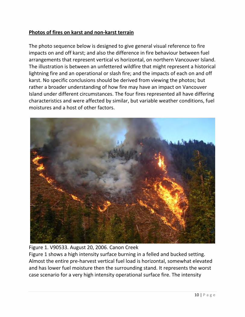
Photos of fires on karst and non-karst terrain The photo sequence below is designed to give general visual reference to fire impacts on and off karst; and also the difference in fire behaviour between fuel arrangements that represent vertical vs horizontal, on northern Vancouver Island. The illustration is between an unfettered wildfire that might represent a historical lightning fire and an operational or slash fire; and the impacts of each on and off karst. No specific conclusions should be derived from viewing the photos; but rather a broader understanding of how fire may have an impact on Vancouver Island under different circumstances. The four fires represented all have differing characteristics and were affected by similar, but variable weather conditions, fuel moistures and a host of other factors.
Figure 1. V90533. August 20, 2006. Canon Creek Figure 1 shows a high intensity surface burning in a felled and bucked setting. Almost the entire pre-harvest vertical fuel load is horizontal, somewhat elevated and has lower fuel moisture then the surrounding stand. It represents the worst case scenario for a very high intensity operational surface fire. The intensity
11 | P a g e
represented in the photo is of higher intensity than what would be experienced in a cutblock where harvesting has been completed.
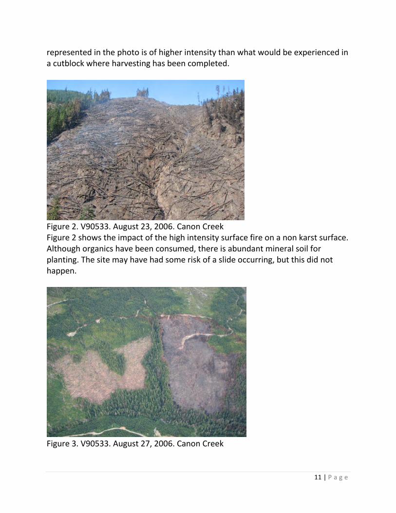
Figure 2. V90533. August 23, 2006. Canon Creek Figure 2 shows the impact of the high intensity surface fire on a non karst surface. Although organics have been consumed, there is abundant mineral soil for planting. The site may have had some risk of a slide occurring, but this did not happen.
Figure 3. V90533. August 27, 2006. Canon Creek
12 | P a g e
Figure 3 shows a site overview and effects of fire suppression actions. This fire was of short duration. Road and retardant drops across the top of fire were effective. Moderating terrain and excellent access allowed quick deployment of ground resources and prevented further upslope movement of the fire. A large retention old growth management area and established regeneration along one flank; a deep gully with riparian management zone along the other flank and Canon Creek with riparian management zone along the bottom, ameliorated fire behaviour until crews could extinguish the perimeter. Sprinkler deployment and favourable winds played a role in stopping the fire from spotting into adjoining cutblock with felled and bucked timber.
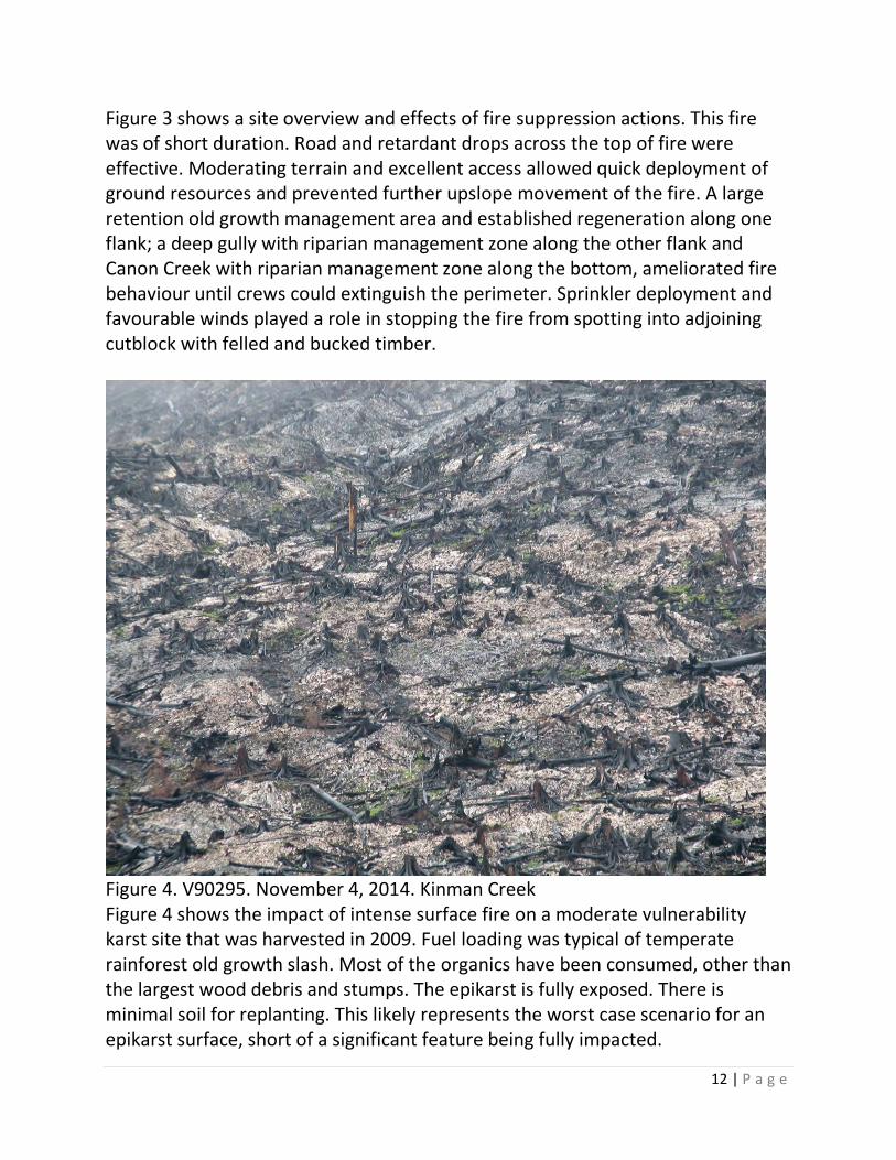
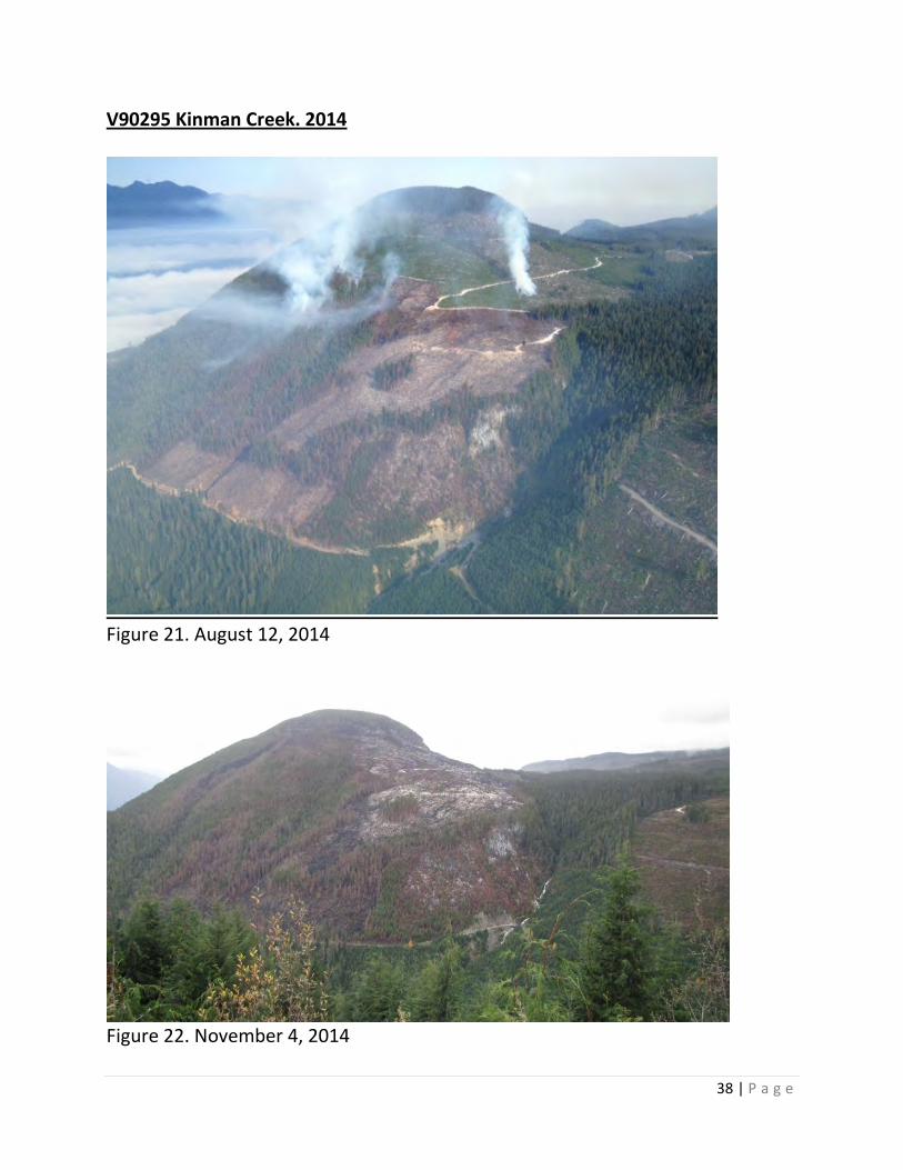
Figure 4. V90295. November 4, 2014. Kinman Creek Figure 4 shows the impact of intense surface fire on a moderate vulnerability karst site that was harvested in 2009. Fuel loading was typical of temperate rainforest old growth slash. Most of the organics have been consumed, other than the largest wood debris and stumps. The epikarst is fully exposed. There is minimal soil for replanting. This likely represents the worst case scenario for an epikarst surface, short of a significant feature being fully impacted.
13 | P a g e
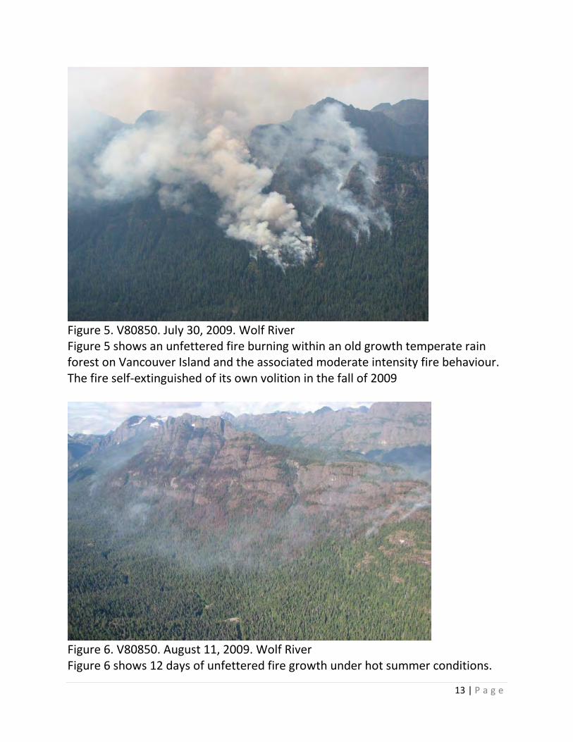
Figure 5. V80850. July 30, 2009. Wolf River Figure 5 shows an unfettered fire burning within an old growth temperate rain forest on Vancouver Island and the associated moderate intensity fire behaviour. The fire self-extinguished of its own volition in the fall of 2009
Figure 6. V80850. August 11, 2009. Wolf River Figure 6 shows 12 days of unfettered fire growth under hot summer conditions.
14 | P a g e
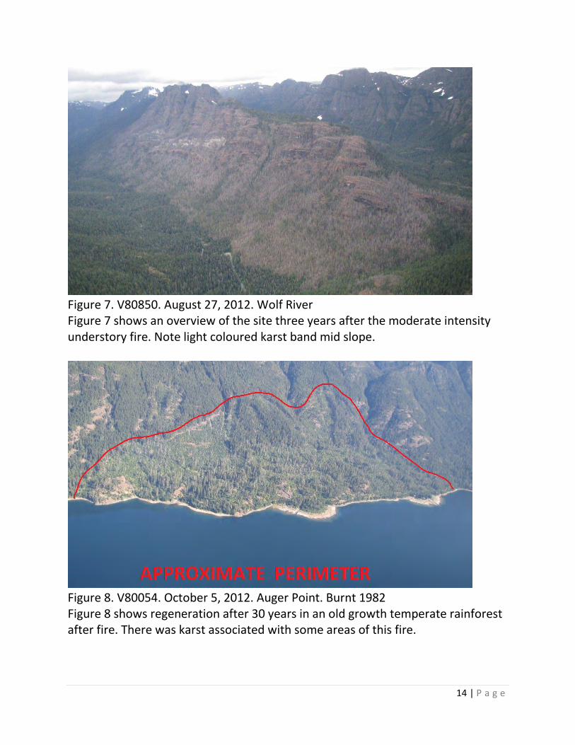
Figure 7. V80850. August 27, 2012. Wolf River Figure 7 shows an overview of the site three years after the moderate intensity understory fire. Note light coloured karst band mid slope.
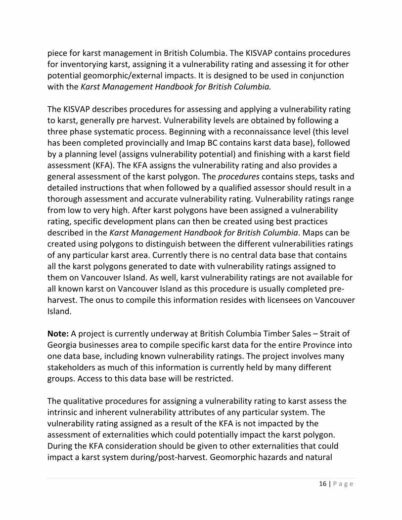
Figure 8. V80054. October 5, 2012. Auger Point. Burnt 1982 Figure 8 shows regeneration after 30 years in an old growth temperate rainforest after fire. There was karst associated with some areas of this fire.

15 | P a g e
Although not currently applied, the use of anthropogenic prescribed (and un-prescribed in the early 20th century) broadcast fire in the past on karst was widely accepted (Post 1980’s + - the prescribed fire practice moved to pile and burn). Generally, it is now understood that this type of fire use on karst was likely not often a good prescription for silviculture purposes; or because of the potentially negative effects on the karst itself. Impacts from prescribed broadcast fire use in the past have been studied, but impacts on the subterranean components of karst systems are not well known, although anecdotal observations exist. Tree regeneration where it occurs, while positive, is not the only indictor that no damage or negative results occurred. In the absence of baseline studies that describe what biota was in place prior to these historical broadcast slash fires over karst terrain, scientifically understanding how any specific karst ecosystem may have been impacted is problematic. It is understood that karst ecosystems are very complex. Flora or fauna associated exclusively with karst ecosystems may not be very adaptive due to the slow development of karst ecosystems and historically low disturbance rate associated with most karst ecosystems on Vancouver Island. Therefore, a cautionary approach is imperative when considering fuel hazard management/practices and wildfire management/practices on karst terrain. 4. Karst and Fire Management Karst Management in British Columbia is guided by two documents. Both are useful when considering how fire might affect, and best be managed, on karst terrain.
• The Karst Inventory Standards and Vulnerability Assessment Procedures for British Columbia (KISVAP)
• Karst Management Handbook for British Columbia (Handbook) The Karst Inventory Standards and Vulnerability Assessment Procedures for British Columbia An important document to consider when discussing wildfire management and fuel hazard management practice is the KISVAP. This document is a key guidance
16 | P a g e
piece for karst management in British Columbia. The KISVAP contains procedures for inventorying karst, assigning it a vulnerability rating and assessing it for other potential geomorphic/external impacts. It is designed to be used in conjunction with the Karst Management Handbook for British Columbia. The KISVAP describes procedures for assessing and applying a vulnerability rating to karst, generally pre harvest. Vulnerability levels are obtained by following a three phase systematic process. Beginning with a reconnaissance level (this level has been completed provincially and Imap BC contains karst data base), followed by a planning level (assigns vulnerability potential) and finishing with a karst field assessment (KFA). The KFA assigns the vulnerability rating and also provides a general assessment of the karst polygon. The procedures contains steps, tasks and detailed instructions that when followed by a qualified assessor should result in a thorough assessment and accurate vulnerability rating. Vulnerability ratings range from low to very high. After karst polygons have been assigned a vulnerability rating, specific development plans can then be created using best practices described in the Karst Management Handbook for British Columbia. Maps can be created using polygons to distinguish between the different vulnerabilities ratings of any particular karst area. Currently there is no central data base that contains all the karst polygons generated to date with vulnerability ratings assigned to them on Vancouver Island. As well, karst vulnerability ratings are not available for all known karst on Vancouver Island as this procedure is usually completed pre-harvest. The onus to compile this information resides with licensees on Vancouver Island. Note: A project is currently underway at British Columbia Timber Sales – Strait of Georgia businesses area to compile specific karst data for the entire Province into one data base, including known vulnerability ratings. The project involves many stakeholders as much of this information is currently held by many different groups. Access to this data base will be restricted. The qualitative procedures for assigning a vulnerability rating to karst assess the intrinsic and inherent vulnerability attributes of any particular system. The vulnerability rating assigned as a result of the KFA is not impacted by the assessment of externalities which could potentially impact the karst polygon. During the KFA consideration should be given to other externalities that could impact a karst system during/post-harvest. Geomorphic hazards and natural
17 | P a g e
disturbances as they might relate to a geomorphic event is an example. Fire/burned areas are referenced in the procedures, but only from the perspective of; has a fire occurred and what might be the possible implications to the karst in question from a landslide or soil erosion. The procedures require that burned areas are recorded, the potential consequences assessed and determining if further investigation/assessment is required by a qualified person. All assessments and recommendations by qualified people should be noted in the KFA. Fire as it pertains to karst is addressed twice in the KISVAP;
• 3.3.6 Task 6 – Identification of geomorphic hazards. Page 25. This step occurs at the planning level. There is also a reference to Appendix B which defines the extent to which fire/burn areas need to be considered in respect to geomorphic hazard during this step, which is noted as ‘extent and intensity’
• 4.3.14 Geomorphic hazards. This step occurs during the KFA. Once again fire/burned area are considered for potential consequences to the karst, primarily from a geomorphic hazard stand point. Outcomes of the KFA may require further assessment of a geomorphic hazard by a qualified person.
When assessing for fires on any given karst polygon it is important to consider on and off site fire disturbances, as the potential impacts could originate from areas up or downslope of the karst polygon being assessed. When a wildfire disturbance does occur on a karst polygon with an existing vulnerability rating, if further activity is planned, the polygon should be re-assessed to determine if the vulnerability rating has changed. Not unlike a geomorphic event, fire can originate from manmade and natural causes. Fire can also have micro landscape impact as we have seen on North Vancouver Island karst. Certain sites will have higher fire risk attributes based on aspect, slope steepness, fuel loading, fuel composition, public access, adjoining cutblocks and other criteria. Fires that occur post-harvest can have geomorphic impacts on karst. Consideration of fire risk and the potential impact a fire could have on karst during the KFA would show good due diligence and could lead to more efficient
18 | P a g e
layout/design and also factor into hazard assessments, broader fuel management plan considerations and fire risk mitigation. Any karst polygon with a vulnerability rating of moderate or higher has the potential for significant disturbance if a broadcasting fire occurs on a recently harvested area, including soil loss and erosion. Most of Vancouver Island karst is above moderate vulnerability (80-90% + -). Vulnerability ratings and significant karst feature location information is essential when developing fuel hazard and wildfire management plans. Due to sensitivity associated with specific significant karst features this information should be treated with confidentiality and not necessarily captured on documents where these locations could be divulged to the general public. For consideration: Fire and fire risk to karst is not applicable to the vulnerability rating. However, it should be considered in the geomorphic assessment aspects of the KFA. Recognizing and considering fire risk and implications of intense surface fire to any specific karst polygon and the broader landscape prior to harvesting is good practice. Early recognition in identifying and managing fire risk to karst terrain through fuel hazard assessments or broader fuel management plans can lead to operational efficiency gains and reduce impacts to karst from prescribed fire and wildfire should it occur. Best Management Practices for Prescribed Burning on/near Karst After a vulnerability rating has been assigned to a karst polygon the BMPs located in the Karst Management Handbook for British Columbia pertaining to prescribed burning should be adhered to. Best practices in the Handbook as they pertain to wildfire and karst are meager. Other areas of best practice in the Handbook should be reviewed with an eye to wildfire, although this was not the original intent. Specifically, retention and road deactivation. Best practice for retention of timber was originally designed to reduce the potential impacts of harvesting on a specific karst feature or very high vulnerability karst terrain. Retention also has a direct relationship to fire. The high intensity burning and fast spread rates associated with slash fires will decrease when they burn into larger areas of retained timber along a cutblock boundary.
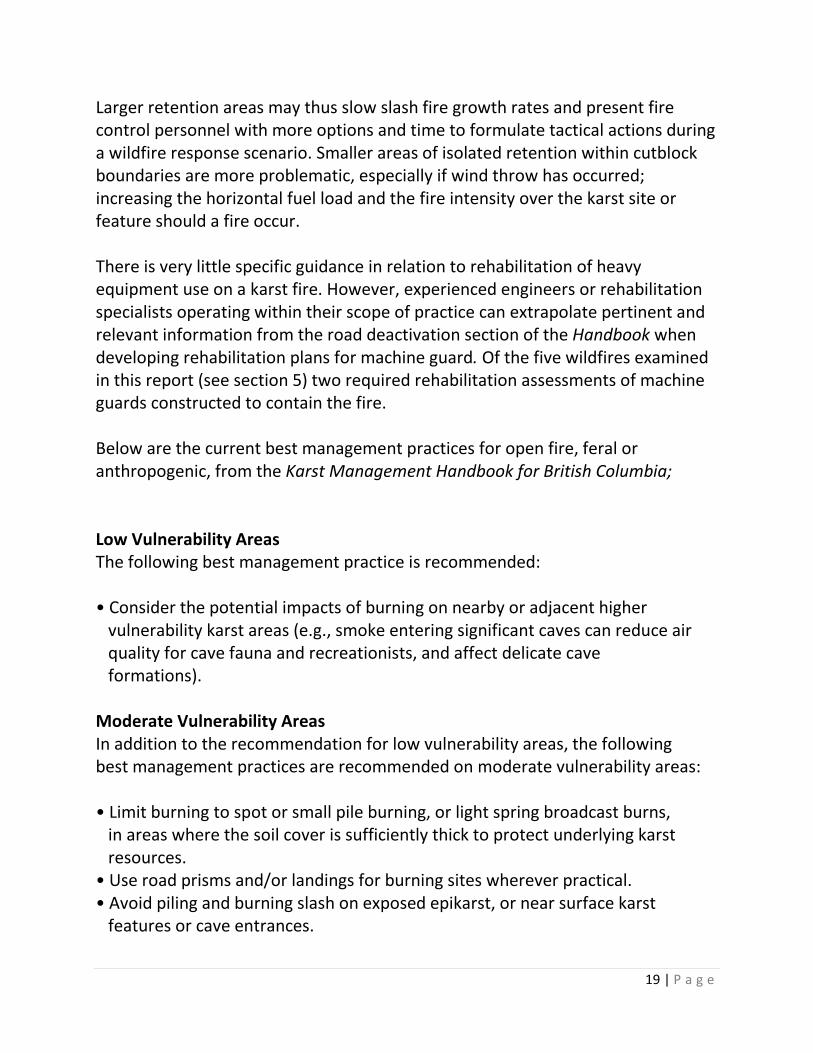
19 | P a g e
Larger retention areas may thus slow slash fire growth rates and present fire control personnel with more options and time to formulate tactical actions during a wildfire response scenario. Smaller areas of isolated retention within cutblock boundaries are more problematic, especially if wind throw has occurred; increasing the horizontal fuel load and the fire intensity over the karst site or feature should a fire occur. There is very little specific guidance in relation to rehabilitation of heavy equipment use on a karst fire. However, experienced engineers or rehabilitation specialists operating within their scope of practice can extrapolate pertinent and relevant information from the road deactivation section of the Handbook when developing rehabilitation plans for machine guard. Of the five wildfires examined in this report (see section 5) two required rehabilitation assessments of machine guards constructed to contain the fire. Below are the current best management practices for open fire, feral or anthropogenic, from the Karst Management Handbook for British Columbia; Low Vulnerability Areas The following best management practice is recommended: • Consider the potential impacts of burning on nearby or adjacent higher vulnerability karst areas (e.g., smoke entering significant caves can reduce air quality for cave fauna and recreationists, and affect delicate cave formations). Moderate Vulnerability Areas In addition to the recommendation for low vulnerability areas, the following best management practices are recommended on moderate vulnerability areas: • Limit burning to spot or small pile burning, or light spring broadcast burns, in areas where the soil cover is sufficiently thick to protect underlying karst resources. • Use road prisms and/or landings for burning sites wherever practical. • Avoid piling and burning slash on exposed epikarst, or near surface karst features or cave entrances.
20 | P a g e
• Avoid the use of chemical fire retardants/suppressants. • As an alternative to burning, consider accumulating and leaving slash in small piles; locate these piles away from exposed epikarst, surface karst features, and cave entrances. High Vulnerability Areas In addition to the recommendations for low and moderate vulnerability areas, the following best management practice is recommended on high vulnerability areas: • Broadcast burning should not occur on high vulnerability areas. For Consideration: Examine open fire best management practices in the Karst Management Handbook for British Columbia for implementation and effectiveness. Consider updating (or include reference) to better reflect contemporary fuel hazard best management practices as it relates to karst and assess aspects of fire control operations for inclusion (or reference) . Other considerations: For professionals engaged in fuel hazard management and prescribed fire on or near karst, beyond BMPs as noted in the Handbook;
• Consider block design in relation to potential fire behaviour and sensitive karst. While it is understood certain sites will present few alternatives due to the physics associated with old growth wood harvesting; if design and site plan can efficiently incorporate fuel hazard management best practices and mitigate potential fuel hazards and fire risk post-harvest it should be considered
• If practical, consider alternate harvesting methodology around significant karst features that may improve resistance to unwanted fire and reduce fuel loading close to the feature.
• Consider leaving fuel dispersed if burning piles is inefficient or raises concerns about underlying epikarst. Unburnt piles, even small ones can contribute to fire spread rates and create control difficulties during fire season if ignition occurs
• Consider; larger retention areas around significant karst features may provide more protection from the effects of unwanted fire. Note: the handbook BMPs recommend minimum one and two tree length reserves around all significant surface karst features
21 | P a g e
• Consider restricting access (gate) to sites with significant karst features and vulnerable karst post-harvest to limit potential of anthropogenic ignition
Fire Behaviour Associated with Karst Fire behaviour forecasting is a challenging speciality within the sphere of fire management for both silviculture use (fuel hazard abatement and other prescriptions) and wildfire management. Accurate fire behaviour forecasting requires an in depth scientific understanding of many environmental variables (program inputs) and experience to intuitively temper and adjust criteria when software modeling lacks sufficient input capacity to formulate the model accurately. It is truly a marriage of science and art. During the summer of 2014 a fire (V90295) occurred on karst in the Kinman Creek drainage on northern Vancouver Island. Observations from some fire management personnel on site indicate that fire behaviour prediction modeling in the slash, regeneration (heavy slash subcomponent) and standing timber over karst areas was under predicting fire spread rates and behaviour. These anecdotal observations deserve further consideration and study given what we know about karst. Fire behaviour modeling is only as accurate as the inputs. Upon further discussions a potential theory for these increased spread rates/intensities was realized. ‘Does the porous nature of karst terrain lead to more rapid draining and higher fuel drying rates compared to other stratum(s) that have better moisture retaining characteristics?’ Intuitively this would seem to make sense, but research will be needed to confirm this hypothesis. If fire weather indices, were higher over karst areas on fire V90295 (than in surrounding terrain types and the weather station data being used) it may provide an explanation for these observed fire spread rates and intensities. Regardless, it would be prudent for fire line supervisors to exercise appropriate caution (as always) and act accordingly to this anecdotal information. As with most slash fires burning in temperate rain forest on Vancouver Island, slower spread rates and less intensity were associated with Fire V90295 in the tree line (beyond shade line) and in the established regeneration, compared to recently harvested areas with high fuel loading.
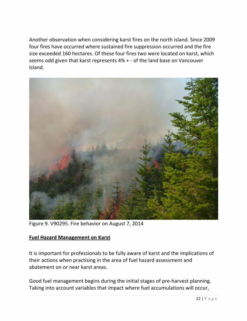
22 | P a g e
Another observation when considering karst fires on the north island. Since 2009 four fires have occurred where sustained fire suppression occurred and the fire size exceeded 160 hectares. Of these four fires two were located on karst, which seems odd given that karst represents 4% + - of the land base on Vancouver Island.
Figure 9. V90295. Fire behavior on August 7, 2014 Fuel Hazard Management on Karst It is important for professionals to be fully aware of karst and the implications of their actions when practising in the area of fuel hazard assessment and abatement on or near karst areas. Good fuel management begins during the initial stages of pre-harvest planning. Taking into account variables that impact where fuel accumulations will occur,
23 | P a g e
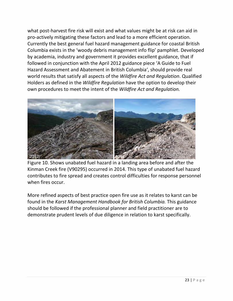
what post-harvest fire risk will exist and what values might be at risk can aid in pro-actively mitigating these factors and lead to a more efficient operation. Currently the best general fuel hazard management guidance for coastal British Columbia exists in the ‘woody debris management info flip’ pamphlet. Developed by academia, industry and government it provides excellent guidance, that if followed in conjunction with the April 2012 guidance piece ‘A Guide to Fuel Hazard Assessment and Abatement in British Columbia‘, should provide real world results that satisfy all aspects of the Wildfire Act and Regulation. Qualified Holders as defined in the Wildfire Regulation have the option to develop their own procedures to meet the intent of the Wildfire Act and Regulation.
Figure 10. Shows unabated fuel hazard in a landing area before and after the Kinman Creek fire (V90295) occurred in 2014. This type of unabated fuel hazard contributes to fire spread and creates control difficulties for response personnel when fires occur. More refined aspects of best practice open fire use as it relates to karst can be found in the Karst Management Handbook for British Columbia. This guidance should be followed if the professional planner and field practitioner are to demonstrate prudent levels of due diligence in relation to karst specifically.
24 | P a g e
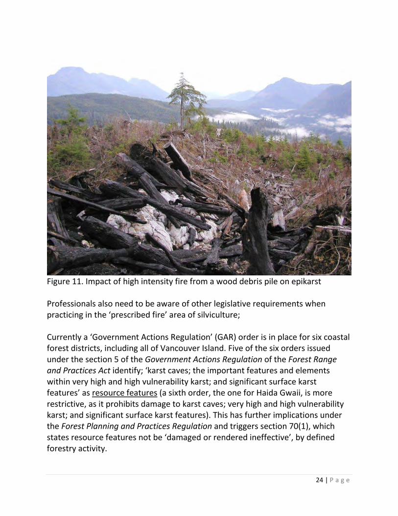
Figure 11. Impact of high intensity fire from a wood debris pile on epikarst Professionals also need to be aware of other legislative requirements when practicing in the ‘prescribed fire’ area of silviculture; Currently a ‘Government Actions Regulation’ (GAR) order is in place for six coastal forest districts, including all of Vancouver Island. Five of the six orders issued under the section 5 of the Government Actions Regulation of the Forest Range and Practices Act identify; ‘karst caves; the important features and elements within very high and high vulnerability karst; and significant surface karst features’ as resource features (a sixth order, the one for Haida Gwaii, is more restrictive, as it prohibits damage to karst caves; very high and high vulnerability karst; and significant surface karst features). This has further implications under the Forest Planning and Practices Regulation and triggers section 70(1), which states resource features not be ‘damaged or rendered ineffective’, by defined forestry activity.
25 | P a g e
Currently licensees on Vancouver Island are burning under the Resource Management Burn Plan (RMBP)/Category 4 or Category 3 administrative/legal processes. Both are subject to the GAR order(s) as it pertains to prescribed fire damaging or rendering ineffective any identified karst resource features. Under category 4/ RMBP, broadcasting fire outside of piled debris is acceptable given ameliorated burning conditions experienced during the fall on Vancouver Island. However, this outcome may not be desired in a karst sensitive site. Professionals engaged in prescribed fire practice should understand the GAR orders and the Forest Planning and Practices Regulation s.70(1) implications. Professionals engaged in planning and prescribed open fire use on or near karst need to ensure that adequate planning ensues prior to harvesting that ensures fuel loads are managed appropriately and a wide variety of other criteria is assessed. Various site plan factors, ongoing fire risk factors, prevention planning and abatement strategy are some considerations and are part of a good hazard assessment or fuel management plan. Good planning and adherence to best practice can aid fire response personnel immensely if a fire does occur during the fire season. Taking note of karst in the hazard assessment or broader fuel management plan and documenting special treatments/actions to manage all aspects of fuel hazard, risk and values in relation to karst and fire use is good practice and demonstrates due diligence. As well, longer term development plans in karst polygons should be assessed for broader landscape changes that could raise fire risk considerations. For example, if 6 separate cutblocks are planned for a karst area within a fairly tight geographic area and over a relatively short time period, the hazard assessment may evaluate what the fire risk for the entire area is, not just an individual cutblock. As we have seen, fires occurring in one cutblock can easily expand into others. Specifically, a fire occurring in a cutblock with a low vulnerability rating can easily spread into an adjoining cut block with a higher vulnerability rating and/or potentially impact significant karst sites or features located in a retention area far removed from the point of ignition.
26 | P a g e
5. Wildfire Management on Karst The Mandate of the British Columbia Wildfire Service (BCWS) as stated in the Strategic Plan reads as follows; Deliver effective wildfire management and emergency response support on behalf of the government of British Columbia to protect life and values at risk and to encourage sustainable, healthy and resilient ecosystems. Two bullets from the BCWS mission statement read as follow;
• Provide for the safety of our workers and the public • Deliver effective, innovative and cost efficient wildfire management services
Continuous improvement and examining how BCWS approaches wildfire management in karst terrain on Vancouver Island is incumbent on the organisation to ensure utilization of the safest and most effective methods practical; as our knowledge, understanding and experience in regards to wildfire management on karst terrain grow. As mentioned earlier, our understanding of how a fire disturbance impacts karst ecosystems, especially their subterranean components, is not well understood. While at the same time consensus suggest that broadcasting fire in most circumstances, and certainly under hot summer conditions, is not a good outcome for a variety of reasons. Safety risks to response personnel, high suppression costs, regeneration mortality, merchantable timber loss and potential impacts to karst ecosystems are some obvious reasons. Our lack of understanding on the potential impacts to karst systems due to high intensity surface fire obligates BCWS (and other land users) to use the best science and practice available in the prevention and management of wildfires when they occur on karst. A cautionary approach until the ramifications of open fire on karst are better understood should be an imperative moving forward. The intent of this document in relation to wildfire management on karst is to ensure situational awareness and stimulate discussion to ensure BCWS is using all available resources and information to ensure fire prioritization, on-site tactical
27 | P a g e
decisions and rehabilitation plans take into account karst when fires occur on this terrain type. Nothing in the discussion or considerations as it relates to this paper should ever increase risk to worker safety in order to protect any specific karst value, but rather better inform the risk assessment using our best knowledge and common sense, while increasing situational awareness in regards to safety as it pertains to the karst environment. As well, it is understood that tactical/strategic decisions made by the on-site Incident Commander (IC) and remotely located Regional Wildfire Co-ordination Officer (RWCO) take into account a wide range of values and variables that are often dynamic. This most often occurs in time compressed situations. Karst is just one of these values. Physical landscape realities often leave few options for on-site resources engaged in fire control actions and wildfire is unpredictable. There is no intent in this document to use hindsight 20/20 to question decisions, but rather to better inform future decisions though consideration and discussion moving forward. Karst Fires on North Vancouver Island 2007 -2014
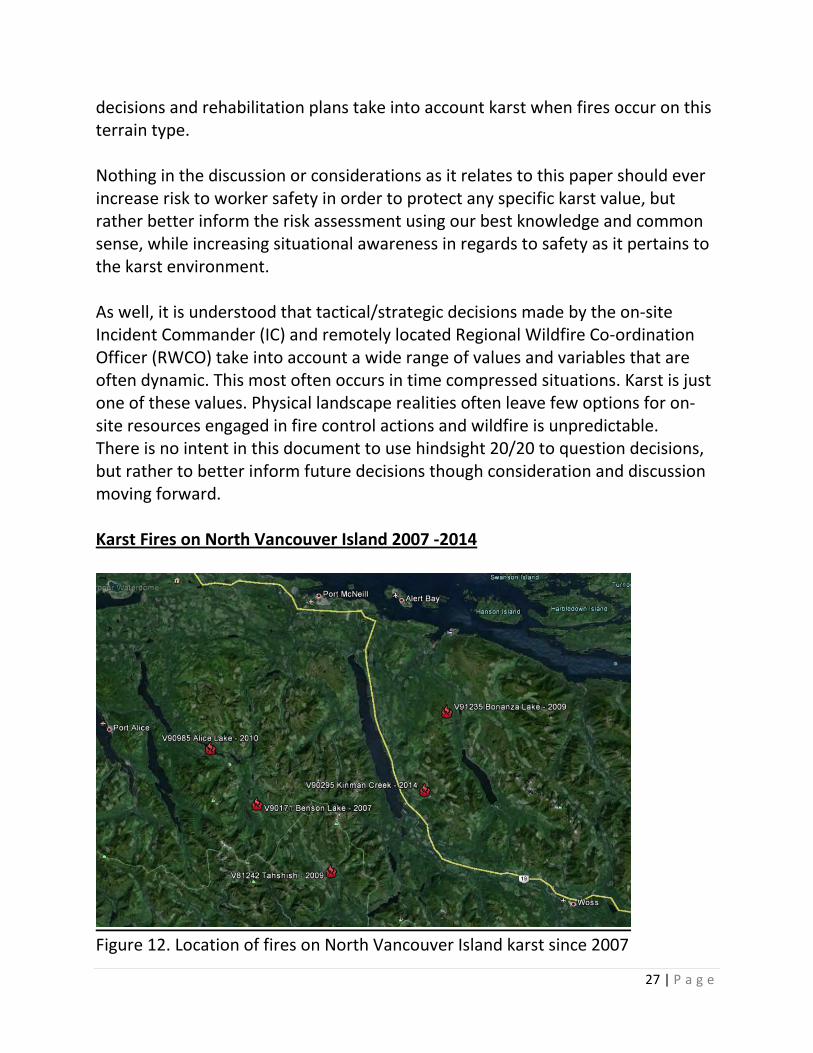
Figure 12. Location of fires on North Vancouver Island karst since 2007
28 | P a g e
This paper describes recent fire events but does not evaluate historic fire on karst. Many anthropogenic and lightning caused fires have occurred on karst on North Vancouver Island over the years. This paper singles out the last five wildfires that have occurred on North Vancouver Island karst and highlights some of the operational aspects and other environmental data. It examines the requirement for, and effectiveness of resources, and whether other potential considerations exist in relation to karst for the onsite IC, the RWCO and other BCWS personnel when engaged in wildfire management on karst terrain. In summary the paper also examines several areas of the BCWS structure to see if any improvements might be realized. Two of the karst fires being assessed in this paper were large fires by North Vancouver Island standards, given the fire response and suppression action. Part of the reason these fires became large was due to an altered fuel complex (logging slash) that supports an intensive fire regime in the short range. Historically (15 + years ago), the general landscape on North Vancouver Island, represented in this discussion by fuel type changes between old growth standing timber and harvested areas, allowed BCWS and industry personnel opportunities to contain intense slash fires as they burned into leave strips or old growth cutblock boundaries. Generally speaking, old growth areas are being harvested and replanted on North Vancouver Island. Fuel loading associated with old growth North West Pacific temperate rainforest and the slash that occurs in this timber type when harvested is relatively high when measured in tonnes per hectare (historically the Pacific Northwest has more biomass per hectare than anywhere else on the planet). When the regeneration becomes free to grow (5-8 years + -) the adjoining old growth forest is often harvested. As well, historical old growth leave strips have essentially all been harvested, or are being harvested. Old growth standing timber is a fuel complex that is much less volatile than slash or young regeneration. Fuel loads associated with second growth harvesting are greatly reduced in comparison (providing good utilization has occurred) as is the volatility of the fire behaviour when it occurs. Second growth stands that are approaching culmination age offer a similar change in fuel type and opportunity for wildfire containment. Generally speaking, this would be more common on southern Vancouver Island. Well established regeneration across all of Vancouver
29 | P a g e
Island can also represent a fuel type change and opportunity for slash fire containment. Contemporary leave strips and retention areas are often not large enough to ameliorate fire intensity enough for fire management personnel to exploit the opportunity that larger leave strips or surrounding forest may have afforded in the past. As the biota has been gradually altered over large areas these landscape changes are changing the way BCWS personnel might approach any given fire in the TFL’s associated with North Vancouver Island and is part of the impetus for this paper. It is a landscape reality and constitutes a situation all response personnel need to be aware of and the short term challenges this may present from a wildfire management perspective on karst, and off. Abbreviated wildfire case study The five fires chosen show an improving trend within BCWS to recognize karst as a unique and valuable non-renewable resource. BCWS is drawing upon lessons learned while fighting fire on karst and working to incorporate this knowledge into ongoing wildfire management operations when they occur on karst. To say the case studies of the following fires are abbreviated is a gross overstatement. Only criteria as they may pertain to karst specifically have been noted, and not exhaustively.
30 | P a g e
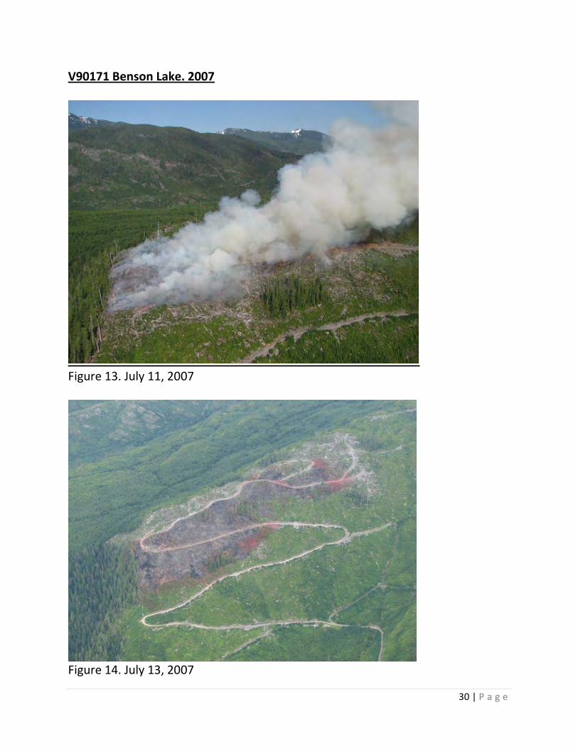
V90171 Benson Lake. 2007
Figure 13. July 11, 2007
Figure 14. July 13, 2007
31 | P a g e
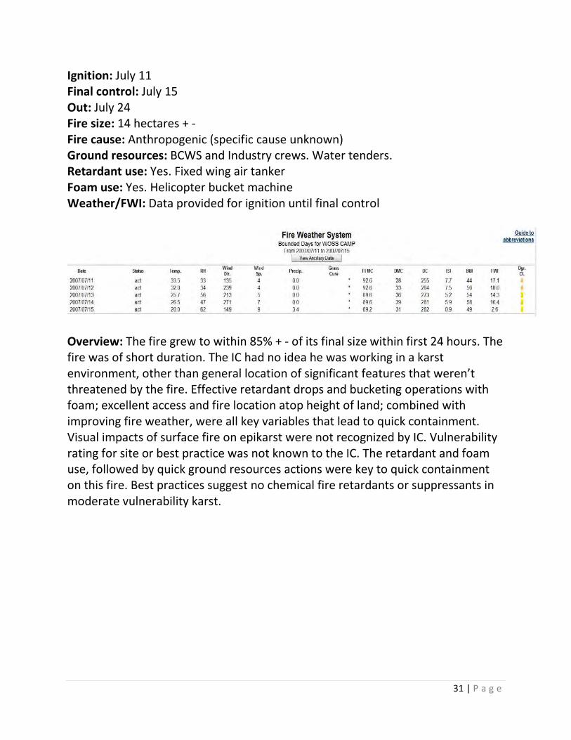
Ignition: July 11 Final control: July 15 Out: July 24 Fire size: 14 hectares + - Fire cause: Anthropogenic (specific cause unknown) Ground resources: BCWS and Industry crews. Water tenders. Retardant use: Yes. Fixed wing air tanker Foam use: Yes. Helicopter bucket machine Weather/FWI: Data provided for ignition until final control
Overview: The fire grew to within 85% + - of its final size within first 24 hours. The fire was of short duration. The IC had no idea he was working in a karst environment, other than general location of significant features that weren’t threatened by the fire. Effective retardant drops and bucketing operations with foam; excellent access and fire location atop height of land; combined with improving fire weather, were all key variables that lead to quick containment. Visual impacts of surface fire on epikarst were not recognized by IC. Vulnerability rating for site or best practice was not known to the IC. The retardant and foam use, followed by quick ground resources actions were key to quick containment on this fire. Best practices suggest no chemical fire retardants or suppressants in moderate vulnerability karst.
32 | P a g e
V81242 Tahshish. 2009
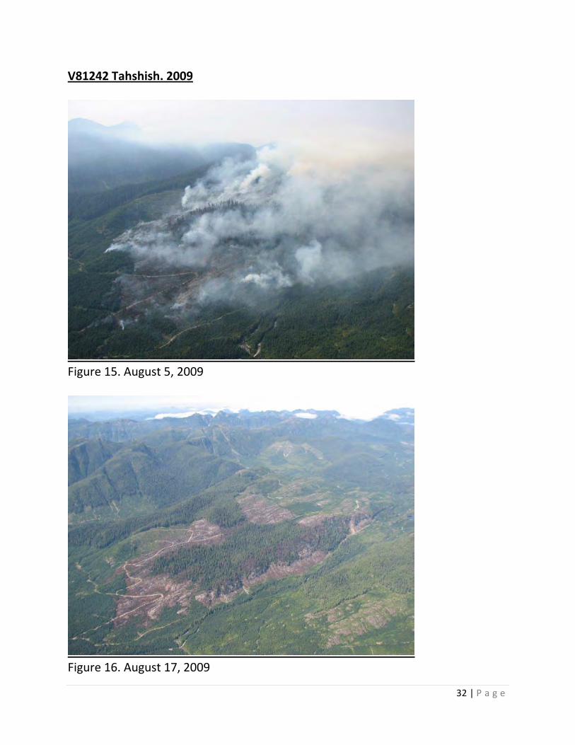
Figure 15. August 5, 2009
Figure 16. August 17, 2009
33 | P a g e
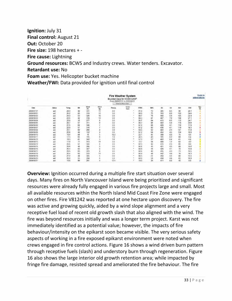
Ignition: July 31 Final control: August 21 Out: October 20 Fire size: 198 hectares + - Fire cause: Lightning Ground resources: BCWS and Industry crews. Water tenders. Excavator. Retardant use: No Foam use: Yes. Helicopter bucket machine Weather/FWI: Data provided for ignition until final control
Overview: Ignition occurred during a multiple fire start situation over several days. Many fires on North Vancouver Island were being prioritized and significant resources were already fully engaged in various fire projects large and small. Most all available resources within the North Island Mid Coast Fire Zone were engaged on other fires. Fire V81242 was reported at one hectare upon discovery. The fire was active and growing quickly, aided by a wind slope alignment and a very receptive fuel load of recent old growth slash that also aligned with the wind. The fire was beyond resources initially and was a longer term project. Karst was not immediately identified as a potential value; however, the impacts of fire behaviour/intensity on the epikarst soon became visible. The very serious safety aspects of working in a fire exposed epikarst environment were noted when crews engaged in fire control actions. Figure 16 shows a wind driven burn pattern through receptive fuels (slash) and understory burn through regeneration. Figure 16 also shows the large interior old growth retention area; while impacted by fringe fire damage, resisted spread and ameliorated the fire behaviour. The fire
34 | P a g e
essentially burnt around the retention area through the more volatile and receptive slash fuel types, while the retention self-extinguished. Fire suppression efforts were perimeter focused on this incident due to elevated safety risk associated with working in exposed karst. Early on a machine guard was quickly abandoned due to potential rehab concerns vs minimal containment benefit. This fire raised the profile and situational awareness of BCWS personnel to the impacts of intense surface fire on karst and especially the safety hazards associated with working in and around exposed epikarst. V91235 Bonanza Lake. 2009
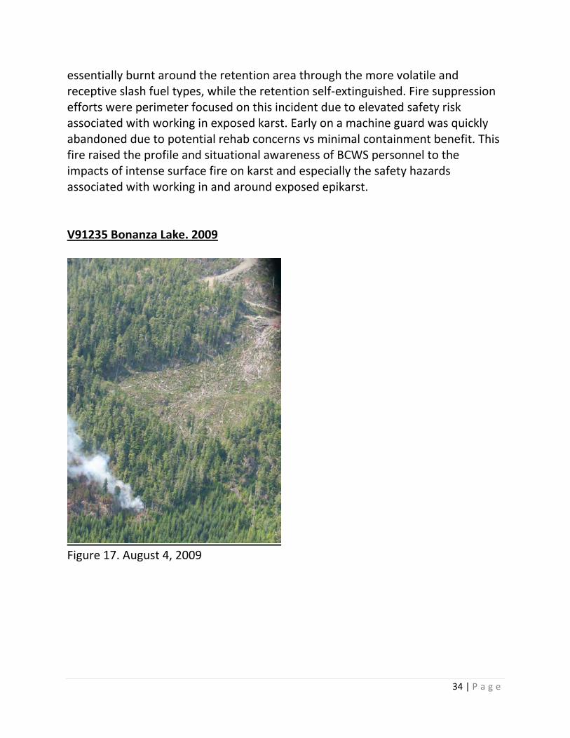
Figure 17. August 4, 2009
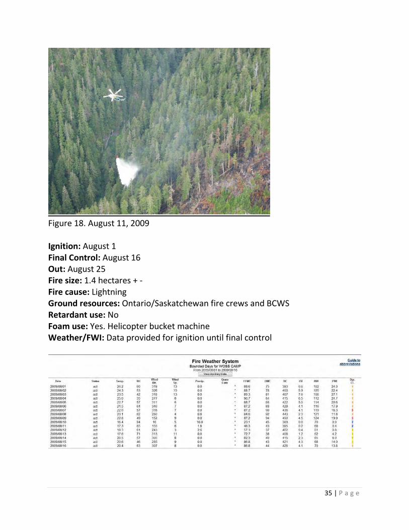
35 | P a g e
Figure 18. August 11, 2009 Ignition: August 1 Final Control: August 16 Out: August 25 Fire size: 1.4 hectares + - Fire cause: Lightning Ground resources: Ontario/Saskatchewan fire crews and BCWS Retardant use: No Foam use: Yes. Helicopter bucket machine Weather/FWI: Data provided for ignition until final control
36 | P a g e
Overview: This fire occurred under the same circumstances as fire V81242. Lack of resources led to a delayed response. Fire spread was ameliorated by old growth and regeneration until a response was mustered and containment actions prevented spread into a more volatile fuel type (recent slash). No knowledge that the site contained karst was apparent or known to fire overhead personnel. The work site, as it pertains directly to the fire, was known to be very steep. V90985 Alice Lake. 2010
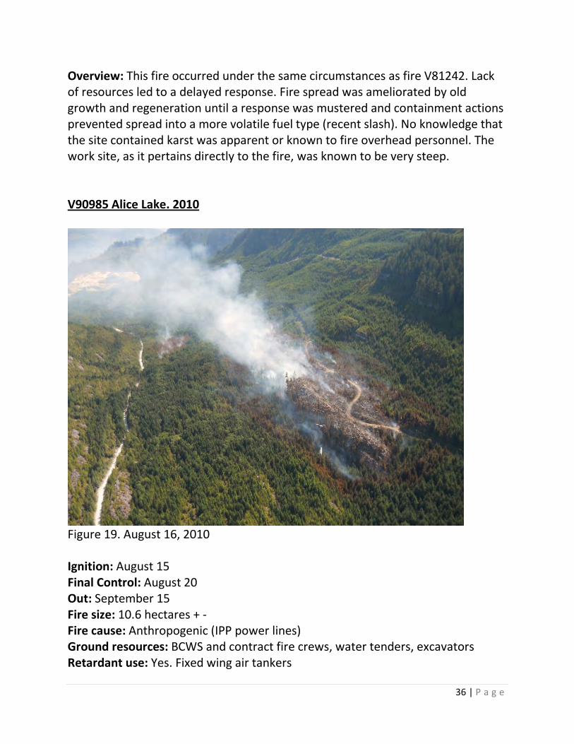
Figure 19. August 16, 2010 Ignition: August 15 Final Control: August 20 Out: September 15 Fire size: 10.6 hectares + - Fire cause: Anthropogenic (IPP power lines) Ground resources: BCWS and contract fire crews, water tenders, excavators Retardant use: Yes. Fixed wing air tankers

37 | P a g e
Foam use: Yes. Helicopter bucket machine Weather/FWI: Data provided for ignition until final control Bounded weather for Artlish weather station unavailable
Overview: This was a short duration fire. The site was recognized as having karst attributes early on and the Fire Analysis Strategy (FAS) recognized karst as a value and noted caution around using heavy equipment. Heavy equipment was used to put machine guard around parts of the fire (Figure 19). The rehabilitation report indicates 1.2 kilometers of guard was constructed. The machine guard was not effective and likely not required. Retardant use along flanks and tail of fire was effective. The fire breeched retardant line at the head. Helicopter bucketing (foam) was also used effectively to support retardant lines and ground resources. The fire did spot 250 + - meters. High localized winds were associated with this fire. Rehabilitation of machine guard was minimal as shallow soils restricted amount of material (soil) available for haul back. Less haul back/disturbance was deemed preferable, when weighed against further potential damage to the epikarst equipment might cause during a rehabilitation operation.
Figure 20. V90985. Machine guard on epikarst
38 | P a g e
V90295 Kinman Creek. 2014
Figure 21. August 12, 2014
Figure 22. November 4, 2014
39 | P a g e
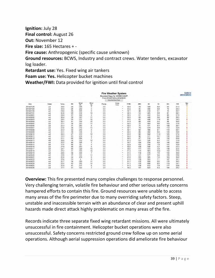
Ignition: July 28 Final control: August 26 Out: November 12 Fire size: 165 Hectares + - Fire cause: Anthropogenic (specific cause unknown) Ground resources: BCWS, Industry and contract crews. Water tenders, excavator log loader. Retardant use: Yes. Fixed wing air tankers Foam use: Yes. Helicopter bucket machines Weather/FWI: Data provided for ignition until final control
Overview: This fire presented many complex challenges to response personnel. Very challenging terrain, volatile fire behaviour and other serious safety concerns hampered efforts to contain this fire. Ground resources were unable to access many areas of the fire perimeter due to many overriding safety factors. Steep, unstable and inaccessible terrain with an abundance of clear and present uphill hazards made direct attack highly problematic on many areas of the fire. Records indicate three separate fixed wing retardant missions. All were ultimately unsuccessful in fire containment. Helicopter bucket operations were also unsuccessful. Safety concerns restricted ground crew follow up on some aerial operations. Although aerial suppression operations did ameliorate fire behaviour

40 | P a g e
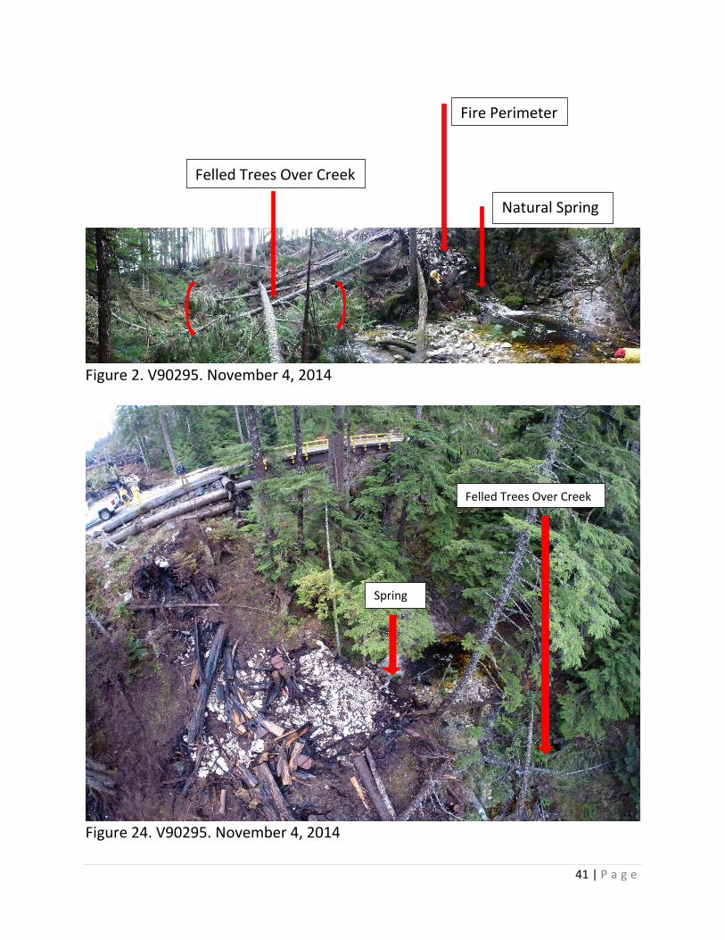
in the slash and regeneration, it was ultimately not a factor in the ‘final control’ of the fire, but rather may have contributed to a reduced final fire size. Communications regarding the karst aspects of the site were generally good. Initial response personnel understood the site had karst through good communications with Industry personnel and the FAS identified karst, and significant karst features, as being a value at risk. Figures 23 and 24 below provide an overview of a natural karst spring. It was a pump site for suppression activities on fire V90295 in 2014. The fire burned through retention and quite close to the natural spring/pump site. Danger tree assessment indicated that trees needed to be felled, presumably due mostly to fire damaged roots, ensuring fire crew safety. The photos raise several questions for consideration.
• When did response personal learn about the location of the natural spring and how was it prioritized in terms of a value?
• Could, or should, the FAS contain more detailed information in regards to karst?
• Should the site have been assessed in a rehabilitation plan? • How has the natural spring and other karst features downstream been
impacted by the felled trees? Or is this just a riparian/creek rehabilitation question?
• Do the felled trees completely covering the creek just downstream of the spring require rehab and if so to what extent?
• If rehab is required from an environmental stand point, does the benefit of clean up outweigh the risk to worker safety involved in an operation of this nature?
• Would a larger retention strip along the creek edge have provided more time for fire fighters to secure their anchor point at the creek before trees had to be felled?
• How should the natural spring be valued and prioritized
41 | P a g e
Figure 2. V90295. November 4, 2014
Figure 24. V90295. November 4, 2014
Felled Trees Over Creek
Spring
Fire Perimeter
Natural Spring
Felled Trees Over Creek

42 | P a g e
For Consideration: More lead time in the recognition of feature locations that are under threat and an understanding of their value is a discussion point. If feature location and value are understood by the IC, potential tactics can be formulated into the broader strategy and the resource prioritized appropriately. This fire raises another observation pertaining to a retention patch adjacent to the natural spring feature and danger tree assessment on karst. As work on this fire progressed some interesting observations were noted and are explored in more detail under the danger tree assessment discussion points (page 45). This fire did present three interesting perspectives from a fire behavior stand point;
• Unfettered upslope/cross slope fire spread in old growth temperate rainforest
• Upslope/cross slope fire spread in coastal slash and regeneration, with limited suppression options but some implementation
• The visual impacts of intense surface fire on two adjacent substrates of igneous rock and karst
Case Study Summary The aforementioned brief case studies provide context and experience for a closer look at some specific areas within BCWS for potential improvements to the practise of wildfire management on Karst. These areas are considered further in the following discussion points. 6. Wildfire Management Discussion Points Dispatch Maps Currently, fires are entered and plotted into the dispatch map system when reported through the dispatch centre. This allows fire location and a wide variety of other information (layers) to be viewed with network access. The Information derived from the dispatch map is one factor a RWCO considers when prioritizing fire response actions. Having a layer added that represents general karst locations
43 | P a g e
would inform the RWCO and others to the potential for a fire on or near karst. This information could help to better inform the RWCO’s decisions. All things being equal, the knowledge of karst terrain could potentially impact prioritization decisions and resources deployed. Initially, vulnerability ratings and specific feature locations shouldn’t be required to aid an RWCO decision and are not suggested for dispatch maps. Any vulnerability above moderate is at high risk for high intensity surface fire (80-90% + - of Vancouver Island karst is above moderate vulnerability). Both Kinman Creek (V90295) and Tahshish (V81242) fires were assessed at moderate vulnerability. This information should be located within the Fire Management Plan and Fire Management Maps should be referenced for all wildfires. Worker Safety
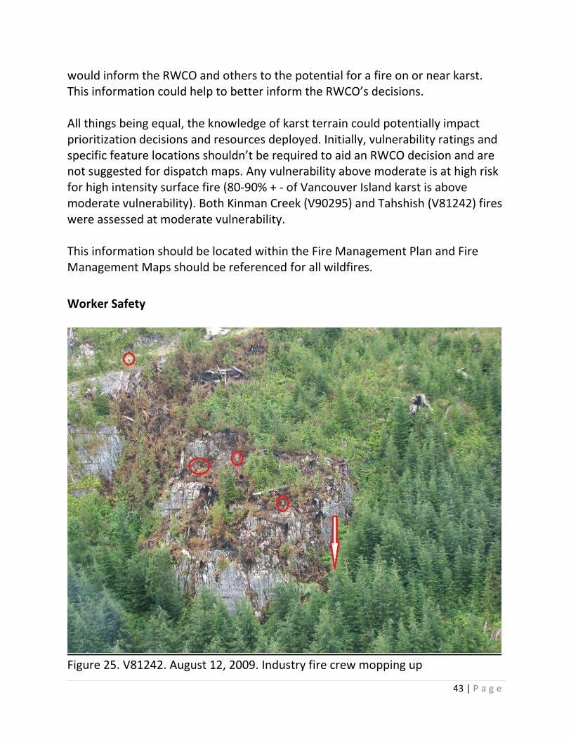
Figure 25. V81242. August 12, 2009. Industry fire crew mopping up
44 | P a g e
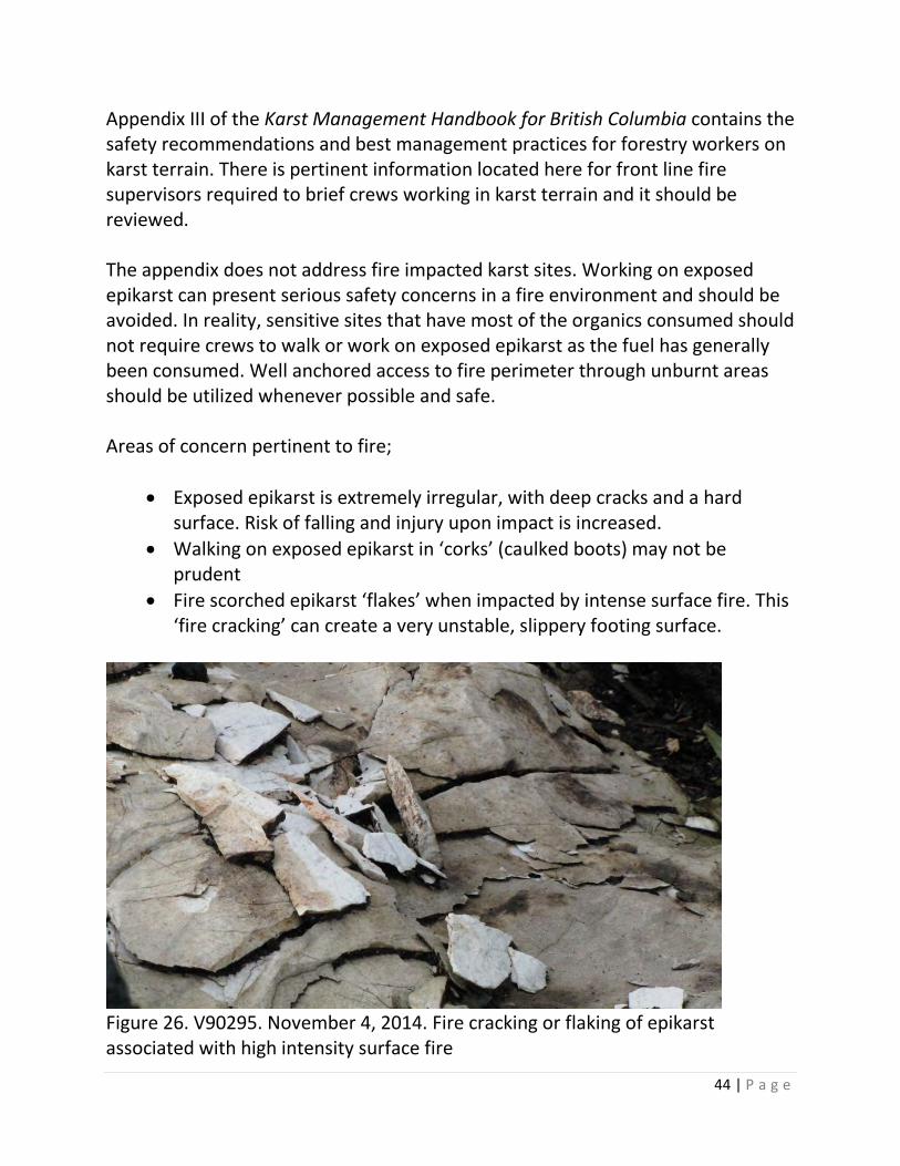
Appendix III of the Karst Management Handbook for British Columbia contains the safety recommendations and best management practices for forestry workers on karst terrain. There is pertinent information located here for front line fire supervisors required to brief crews working in karst terrain and it should be reviewed. The appendix does not address fire impacted karst sites. Working on exposed epikarst can present serious safety concerns in a fire environment and should be avoided. In reality, sensitive sites that have most of the organics consumed should not require crews to walk or work on exposed epikarst as the fuel has generally been consumed. Well anchored access to fire perimeter through unburnt areas should be utilized whenever possible and safe. Areas of concern pertinent to fire;
• Exposed epikarst is extremely irregular, with deep cracks and a hard surface. Risk of falling and injury upon impact is increased.
• Walking on exposed epikarst in ‘corks’ (caulked boots) may not be prudent
• Fire scorched epikarst ‘flakes’ when impacted by intense surface fire. This ‘fire cracking’ can create a very unstable, slippery footing surface.
Figure 26. V90295. November 4, 2014. Fire cracking or flaking of epikarst associated with high intensity surface fire
45 | P a g e
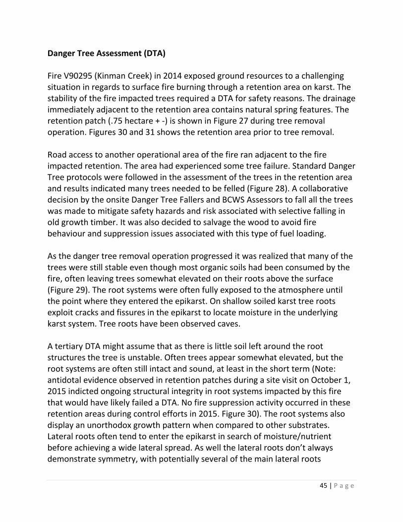
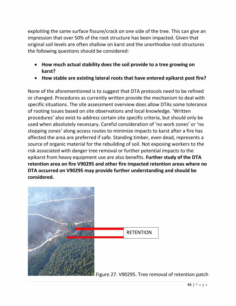
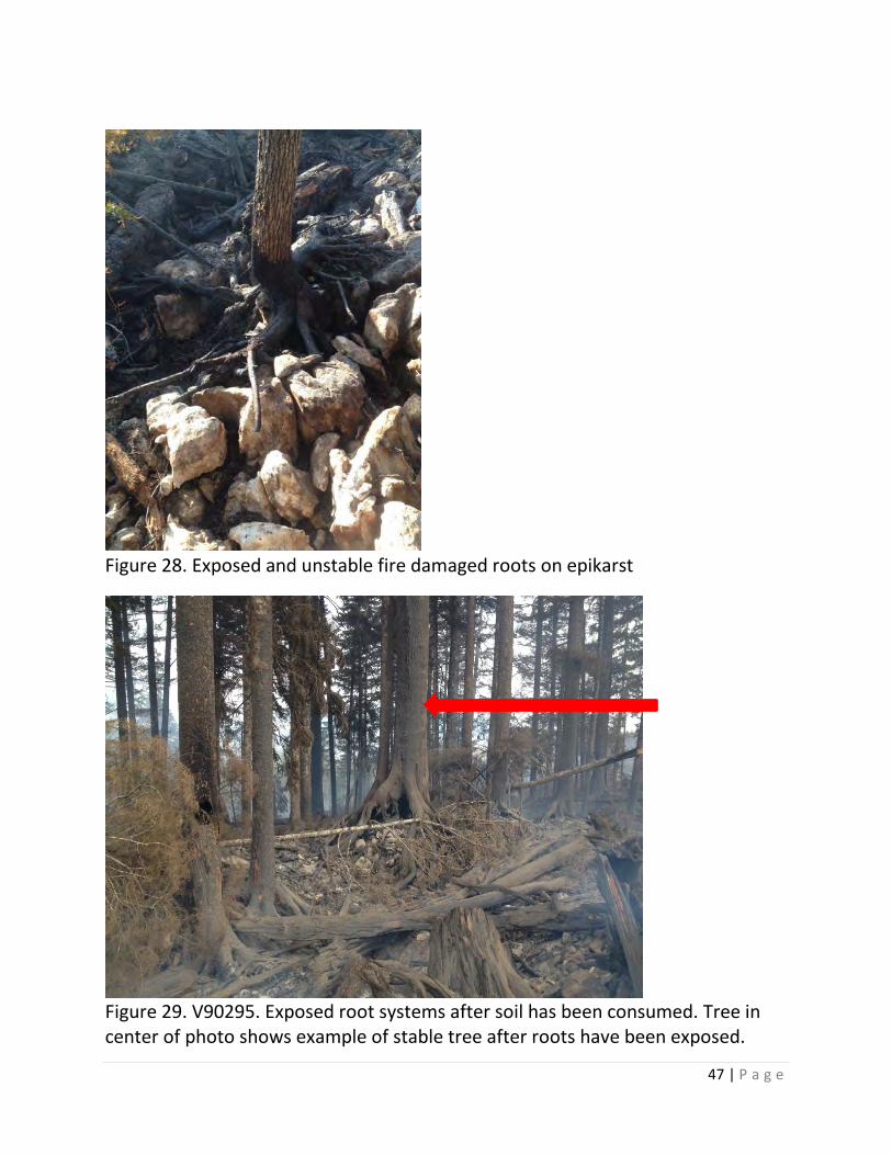
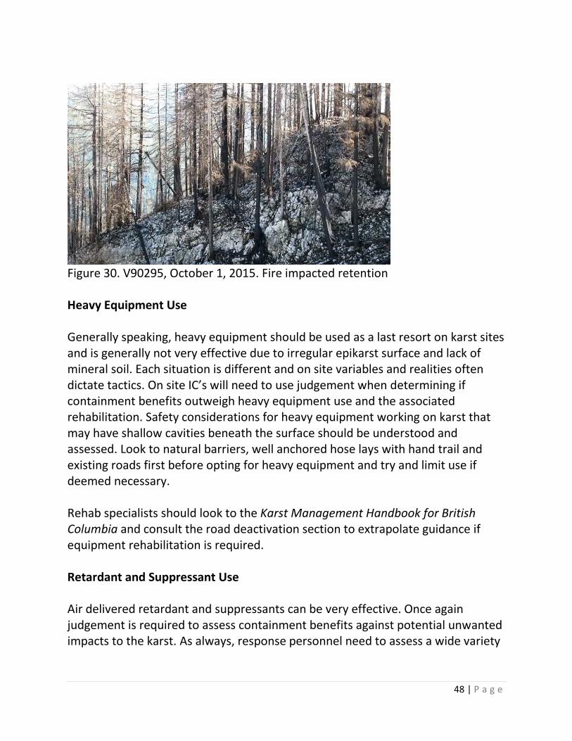
Danger Tree Assessment (DTA) Fire V90295 (Kinman Creek) in 2014 exposed ground resources to a challenging situation in regards to surface fire burning through a retention area on karst. The stability of the fire impacted trees required a DTA for safety reasons. The drainage immediately adjacent to the retention area contains natural spring features. The retention patch (.75 hectare + -) is shown in Figure 27 during tree removal operation. Figures 30 and 31 shows the retention area prior to tree removal. Road access to another operational area of the fire ran adjacent to the fire impacted retention. The area had experienced some tree failure. Standard Danger Tree protocols were followed in the assessment of the trees in the retention area and results indicated many trees needed to be felled (Figure 28). A collaborative decision by the onsite Danger Tree Fallers and BCWS Assessors to fall all the trees was made to mitigate safety hazards and risk associated with selective falling in old growth timber. It was also decided to salvage the wood to avoid fire behaviour and suppression issues associated with this type of fuel loading. As the danger tree removal operation progressed it was realized that many of the trees were still stable even though most organic soils had been consumed by the fire, often leaving trees somewhat elevated on their roots above the surface (Figure 29). The root systems were often fully exposed to the atmosphere until the point where they entered the epikarst. On shallow soiled karst tree roots exploit cracks and fissures in the epikarst to locate moisture in the underlying karst system. Tree roots have been observed caves. A tertiary DTA might assume that as there is little soil left around the root structures the tree is unstable. Often trees appear somewhat elevated, but the root systems are often still intact and sound, at least in the short term (Note: antidotal evidence observed in retention patches during a site visit on October 1, 2015 indicted ongoing structural integrity in root systems impacted by this fire that would have likely failed a DTA. No fire suppression activity occurred in these retention areas during control efforts in 2015. Figure 30). The root systems also display an unorthodox growth pattern when compared to other substrates. Lateral roots often tend to enter the epikarst in search of moisture/nutrient before achieving a wide lateral spread. As well the lateral roots don’t always demonstrate symmetry, with potentially several of the main lateral roots
46 | P a g e
exploiting the same surface fissure/crack on one side of the tree. This can give an impression that over 50% of the root structure has been impacted. Given that original soil levels are often shallow on karst and the unorthodox root structures the following questions should be considered:
• How much actual stability does the soil provide to a tree growing on karst?
• How stable are existing lateral roots that have entered epikarst post fire? None of the aforementioned is to suggest that DTA protocols need to be refined or changed. Procedures as currently written provide the mechanism to deal with specific situations. The site assessment overview does allow DTAs some tolerance of rooting issues based on site observations and local knowledge. ‘Written procedures’ also exist to address certain site specific criteria, but should only be used when absolutely necessary. Careful consideration of ‘no work zones’ or ‘no stopping zones’ along access routes to minimize impacts to karst after a fire has affected the area are preferred if safe. Standing timber, even dead, represents a source of organic material for the rebuilding of soil. Not exposing workers to the risk associated with danger tree removal or further potential impacts to the epikarst from heavy equipment use are also benefits. Further study of the DTA retention area on fire V90295 and other fire impacted retention areas where no DTA occurred on V90295 may provide further understanding and should be considered.
Figure 27. V90295. Tree removal of retention patch
RETENTION
47 | P a g e
Figure 28. Exposed and unstable fire damaged roots on epikarst
Figure 29. V90295. Exposed root systems after soil has been consumed. Tree in center of photo shows example of stable tree after roots have been exposed.
48 | P a g e
Figure 30. V90295, October 1, 2015. Fire impacted retention Heavy Equipment Use Generally speaking, heavy equipment should be used as a last resort on karst sites and is generally not very effective due to irregular epikarst surface and lack of mineral soil. Each situation is different and on site variables and realities often dictate tactics. On site IC’s will need to use judgement when determining if containment benefits outweigh heavy equipment use and the associated rehabilitation. Safety considerations for heavy equipment working on karst that may have shallow cavities beneath the surface should be understood and assessed. Look to natural barriers, well anchored hose lays with hand trail and existing roads first before opting for heavy equipment and try and limit use if deemed necessary. Rehab specialists should look to the Karst Management Handbook for British Columbia and consult the road deactivation section to extrapolate guidance if equipment rehabilitation is required. Retardant and Suppressant Use Air delivered retardant and suppressants can be very effective. Once again judgement is required to assess containment benefits against potential unwanted impacts to the karst. As always, response personnel need to assess a wide variety
49 | P a g e
of criteria and be able to rationalize their decisions, whether retardant is used or not. It is understood that the decision to not use retardant is a difficult one. Although not preferred, it may be prudent to use long term retardant on moderate or high vulnerability karst if the chances of containment success are greatly increased and any further fire spread is stopped, or reduced, before other resource features/values and larger areas of the karst system are potentially impacted by unwanted fire. In vulnerable karst terrain the ability of ground resources to follow up on retardant drops and the increased chances of success need to be carefully considered. If benefit cannot be realized with some confidence, retardant use should likely be avoided. If available, 802 Fire Boss aircraft on floats could deliver straight water and would be a good option.
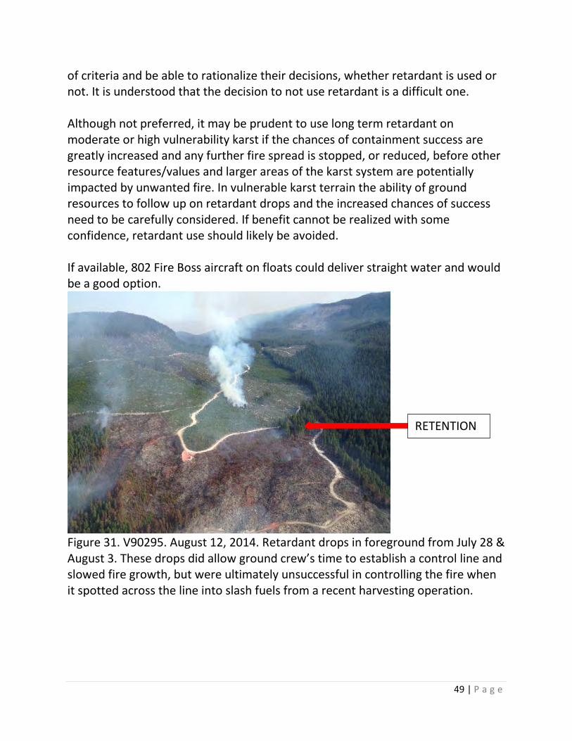
Figure 31. V90295. August 12, 2014. Retardant drops in foreground from July 28 & August 3. These drops did allow ground crew’s time to establish a control line and slowed fire growth, but were ultimately unsuccessful in controlling the fire when it spotted across the line into slash fuels from a recent harvesting operation.
RETENTION
50 | P a g e
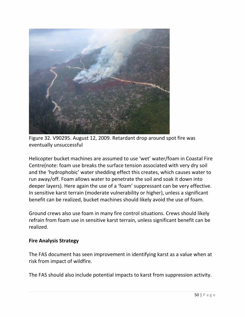
Figure 32. V90295. August 12, 2009. Retardant drop around spot fire was eventually unsuccessful Helicopter bucket machines are assumed to use ‘wet’ water/foam in Coastal Fire Centre(note: foam use breaks the surface tension associated with very dry soil and the ‘hydrophobic’ water shedding effect this creates, which causes water to run away/off. Foam allows water to penetrate the soil and soak it down into deeper layers). Here again the use of a ‘foam’ suppressant can be very effective. In sensitive karst terrain (moderate vulnerability or higher), unless a significant benefit can be realized, bucket machines should likely avoid the use of foam. Ground crews also use foam in many fire control situations. Crews should likely refrain from foam use in sensitive karst terrain, unless significant benefit can be realized. Fire Analysis Strategy The FAS document has seen improvement in identifying karst as a value when at risk from impact of wildfire. The FAS should also include potential impacts to karst from suppression activity.
51 | P a g e
A further improvement might consider the exact location of surrounding features and sensitive karst that could be severely impacted by surface fire. While this information should be treated with sensitivity, having this intelligence well ahead of the curve could allow for better informed fire control actions. Identifying the karst vulnerability rating on the FAS might provide a more detailed insight for authorities involved in the decision making process. Another consideration for the FAS and more broadly is; how should karst be valued and prioritized? The description of karst from the Handbook and as noted in the terms of reference for this paper; and the sensitivity to intense surface fire of Vancouver Island karst, indicate it could (should?) receive a heavy weighting in terms of a resource value. While improvements in the FAS document have been realized and continue in relation to karst, it is important to ensure the ground resources engaged in fire suppression have a good understanding of the FAS in regards to karst. In particular the identified values, how they are prioritized and what the potential impacts of suppression activity may be on identified karst. Timber, water and regeneration values are more widely understood by BCWS field personnel, while karst values are not. Fire Management Plans Fire Management Plans (FMP) for Resource Districts should identify karst, and karst as a resource feature when applicable. Links to more detailed information should be included. Maps associated with FMP’s should look to include available karst vulnerability polygons if possible. FMP’s should indicate how karst should be valued and prioritized in terms of a non-renewable resource feature. These maps should be referenced by BCWS personnel when a fire occurs in the Resource District. Education Senior and experienced BCWS personnel are continuing to better understand fire in all its facets as it pertains to karst; especially when/where they have had exposure to the intermingling of fire and karst. It is important for experienced staff to transfer this knowledge to others at all levels within the organisation. An
52 | P a g e
in-depth knowledge of karst is not required. However, an understanding that karst sites can be very sensitive to intense surface fire and the assorted implications is. Formal broad training is not required for all BCWS staff. If karst is a prevalent feature locally it should be addressed in training with staff at this level.
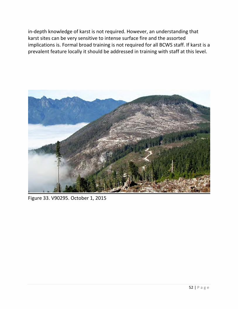
Figure 33. V90295. October 1, 2015

53 | P a g e
7. Summary This paper was written to raise awareness around potentially beneficial actions that could reduce the negative impacts of how fire might impact karst and associated ecosystems, while raising efficiency and safety associated with a multitude of operational scenarios. It does not require or ask for any action, other than an individual’s consideration on how business is conducted in regards to fuel hazard and wildfire management on karst. Hopefully it provides fodder for conversation that perhaps leads to more effective practice(s) and a better understanding of karst and fire on Vancouver Island. This discussion paper represents the opinion of the author alone and should not be affiliated with any association/corporation/agency/individual; be it private, public or governmental that the author has a relationship with. Many people contributed to this paper by providing technical expertise and editing assistance. I thank you all for honest and critical feedback.
Figure 34. V90295. November 4, 2014.
54 | P a g e
8. Reference Materials Karst Management Handbook for British Columbia http://www.for.gov.bc.ca/hfp/publications/00189/Karst-Mgmt-Handbook-web.pdf The Karst Inventory Standards and Vulnerability Assessment Procedure for British Columbia http://www.for.gov.bc.ca/hts/risc/pubs/earthsci/karst_v2/karst_risc.pdf Forest Practices Branch; Karst and Caves http://www.for.gov.bc.ca/hfp/values/features/karst/index.htm FORREX Publication – Karst Chapter http://www.for.gov.bc.ca/hfd/pubs/Docs/Lmh/Lmh66/Lmh66_ch11.pdf Forest Practices Board – Management of Karst Resources on Northern Vancouver Island http://www.bcfpb.ca/reports-publications/reports/management-karst-resource-features-northern-vancouver-island Forest Practices Board – Protecting Karst in Coastal BC http://www.bcfpb.ca/reports-publications/reports/protecting-karst-coastal-bc Wildfire Management Branch – Hazard Assessment and Abatement Information http://bcwildfire.ca/Industry_Stakeholders/industry/
Impacts of primary deforestation upon limestone slopes in northern Vancouver Island, British Columbia. Harding 1987 and Harding and Ford 1993. http://www.cancaver.ca/conserv/ford.htm
https://books.google.ca/books?id=whgNDVXFiqYC&pg=PT861&lpg=PT861&dq=harding+1987,+karst&source=bl&ots=WndF6mXeG9&sig=4QQAXccd9U9y6Vj-X_cQMKDKjBc&hl=en&sa=X&ei=8tPcVLrjC8OpogT_uoDwBw&ved=0CB4Q6AEwAQ#v=onepage&q=harding%201987%2C%20karst&f=false
http://link.springer.com/article/10.1007/BF00775297#