white horse beach management plan draft of september 1, 2015
DESCRIPTION
This is a draft of the plan discussed at the September 30, 2015 meeting. It is subject ot change/TRANSCRIPT

PREPARED BY:
Environmental Consulting & Restoration, LLC P.O. Box 1319
Plymouth, MA 02362 (617) 529-3792
WHITE HORSE BEACH DRAFT MANAGEMENT PLAN
SUBMITTED TO:
Town of Plymouth
September 2015

TABLE OF CONTENTS
SECTIONS PAGE
1.0 Introduction 1
2.0 Description of White Horse Beach 3
3.0 Protected Resource Areas 5
4.0 Beach Use and Management 12
5.0 Beach and Dune Maintenace and Restoration Program 16
6.0 Public Education and Outreach 20
7.0 Recommendations 21
8.0 References 24
FIGURES
ATTACHMENTS

DRAFT White Horse Beach Management Plan Page 1 Plymouth, Massachusetts July 2015
Introduction
This Management Plan for White Horse Beach, Plymouth, Massachusetts is proposed as a guidance
document for the management of White Horse Beach activities and to provide reference for the ongoing
restoration and maintenance of wetland resource areas protected by the state Wetland Protection Act
(MGL c. 131 § 40) and the Plymouth Wetlands By-Laws (§196). This Management Plan is organized as
follows:
Section 1 – Goals of the Management Plan;
Section 2 – Description of White Horse Beach: a brief geological history, the history of development
and use, the current management of White Horse Beach, and a description of Town property limits;
Section 3 – Protected Resource Areas: a summary of applicable regulations and a description of
the wetland resource areas;
Section 4 – Beach Use and Management: a description of public beach access points, recreational
activities management and an emergency action plan;
Section 5 – Beach and Dune Maintenance and Restoration: background on the importance of the
program and a description of measures to maintain and restore the beach front as well as the dune
system at White Horse Beach;
Section 6 – Public Education and Outreach: a discussion on ways the public will be informed of the
management efforts outlined in this plan to be undertaken by the Town of Plymouth;
Section 7 – Recommendations: measures to improve the coastal resource areas of White Horse
Beach.
Section 8 – References.

DRAFT White Horse Beach Management Plan Page 2 Plymouth, Massachusetts July 2015
1.1 Goals of the Management Plan
Serve as a reference document for use by managers of White Horse Beach
Provide a summary of White Horse Beach including geologic formation, historical development and
use, and current management
Describe the property limits of White Horse Beach
Describe the statutes and regulations applicable to White Horse Beach and to the protection of its
natural resources
Provide a management program that is consistent with federal, state, and local laws and
regulations
Provide a management program that allows for safe recreational use of the beach and outlines
actions to take in the event of an emergency
Describe beach and dune maintenance and restoration activities to protect natural resources
Outline public education and outreach efforts

DRAFT White Horse Beach Management Plan Page 3 Plymouth, Massachusetts July 2015
2.0 DESCRIPTION OF WHITE HORSE BEACH
2.1 Geological History
White Horse Beach is narrow, low-lying strip of beach approximately 1.35 miles long made up of coastal
beach, coastal dunes, and coastal banks on the outer portion of Cape Cod Bay and extends parallel to
the trend of the coast. It was formed and currently is shaped by coastal processes.
The area of White Horse Beach was formed as a result of the last glacial period, shaped by erosion of
glacial headlands and shallow glacial deposits. The beach is currently reshaped by storm overwash and
wind transport of sand.
The major geologic events which influence the development of the soils in Plymouth County are; the
formation of basement rock during the late Precambrian (Proterozoic) and Paleozoic era, the Pleistocene
glaciation, and post glacial Holocene deposition.
2.2 History of Development and Use
The area of White Horse Beach began developing rapidly at the beginning of the 20th century as
transportation routes sprouted up through the Pine Hills. Assessor records show that the first two
cottages on White Horse Beach were built in 1910. White Horse Beach was established as a public
beach in 1917. Through the 1930’s, 27 cottages were developed along White Horse Beach and by the
1950’s the beach community had grown significantly to over 100 cottages. Today there are over 150
residential homes between White Horse Beach and Taylor Avenue.
2.3 Current Management of White Horse Beach
The current management of the White Horse Beach is maintained by the Town of Plymouth Department
of Public Works, the Marine and Environmental Affairs Departments, and the Recreation Department.
Due to limited resources, management at the White Horse Beach has been very limited. Only about 560
feet of White Horse Beach is supervised by the Recreation Department and consists of 4 on duty life
guards that cover two stations between the south end of the seawall and the condominiums to the south.
There are four marine buoys that mark a “no-boating” area off of White Horse Beach. Other management
consists of response to complaints and periodic inspections as well as trash removal during the summer
season.
2.4 Town Property Limits
According to the Plymouth Assessors Maps, the Town of Plymouth owns the majority of the beach, but
does exclude a small section included with Map 46 Parcels 88F, 88G, and 88H, which are privately
owned and hold rights to the land up to the mean high tide line (see Attachment 6 for the assessors

DRAFT White Horse Beach Management Plan Page 4 Plymouth, Massachusetts July 2015
property cards and more information). The Town has also recently purchased property on Taylor Avenue
near Bartlett Brook, which consists of two lots (Map 45B Lot 24 and Map 45B lot 25). The town also owns
another piece of property, Map 46 Parcel 3, which is planned as a bathhouse facility. See Figure 11 for
the assessor’s maps and Attachment 6 for these property cards.
This beach management plan addresses the Beach, Primary Dune Area, and Taylor Avenue. For the
purposes of this plan, the Beach and Primary Dune Area include the public land to the north of Taylor
Avenue, between White Horse Beach Road and the boat ramp at Boat House Lane, extending to the
extreme low water of Cape Cod Bay. See Attachment 2 for site photographs.

DRAFT White Horse Beach Management Plan Page 5 Plymouth, Massachusetts July 2015
3.0 PROTECTED RESOURCE AREAS
3.1 Summary of Applicable Environmental Laws, Regulations, Orders and Guidelines
The following is a list of the most significant environmental laws, regulations, orders and guidelines applicable to White Horse Beach, organized according to the agency responsible for oversight. Local Town of Plymouth Conservation Commission
Massachusetts Wetlands Protection Act – MGL Chapter 131 §40 and 310 CMR 10.00
Town of Plymouth – Wetlands Protection Bylaw, Chapter 196
Town of Plymouth Parks and Forestry Division/Department of Marine and Environmental Affairs Town of Plymouth Bylaws – Beaches and Parks, Chapter 30 Beach General Rules and Regulations
State
Department of Environmental Protection Wetlands & Waterways Protection Program
Massachusetts Wetlands Protection Act – MGL Chapter 131 §40 and 210 CMR 10.00 (overview and appeal authority of local Conservation Commission decisions)
Executive Office of Energy and Environmental Affairs
Massachusetts Environmental Policy Act (MEPA) Coastal Zone Management Act Executive Order Number 181 Barrier Beaches
Federal Federal Emergency Management Agency (FEMA) Coastal Barriers Resources Act (CBRA) Coastal Barrier Improvement Act (CBIA) U.S. Environmental Protection Agency (EPA)/U.S. Army Corps of Engineers Clean Water Act, Section 404
Town of Plymouth: Conservation Commission
The Plymouth Conservation Commission is a 7 member board appointed by the Board of Selectmen.
The Conservation Commission is the regulatory body responsible for implementation of both the
Massachusetts Wetlands Protection Act (MGL Chapter 131 §40 and 310 CMR 10.00) and the Town of
Plymouth Wetlands Bylaws Chapter 196.
Wetlands Protection Act
The coastal portion of the Wetlands Protection Act (MGL Chapter 131 §40 and 310 CMR 10.00) is the
principal regulation governing the protection of the wetlands resource areas at White Horse Beach.

DRAFT White Horse Beach Management Plan Page 6 Plymouth, Massachusetts July 2015
The Wetland Protection Act (WPA) was implemented in 1978 to define and clarify that process by
establishing standard definitions and uniform procedures by which conservation commissions and the
Department may carry out their responsibilities under M.G.L. c. 131, § 40. The purpose of the MA WPA is
to contribute to the following interest:
- Protection of public and private water supply
- Protection of ground water supply
- Flood control
- Storm damage prevention
- Prevention of pollution
- Protection of land containing shellfish
- Protection of fisheries
- Protection of wildlife habitat
The Wetlands Protection Act has been promulgated by the State but is enforced by the local
Conservation Commission in order to protect these interests.
White Horse Beach consists of the following protected coastal wetland resource areas (moving from the
ocean landward):
- Land Under the Ocean
- Land Containing Shellfish
- Coastal Beaches
- Coastal Dunes
- Barrier Beaches
- Coastal Banks
- Land Subject to Coastal Storm Flowage
A full description of these resource areas and their applicability to White Horse Beach is provided in
Section 3.2.
Other protected wetland resource areas exist in close proximity to WHB and are associated with Bartlett
Pond and Bartlett Brook. These resource areas, however, are considered to be outside the limits of WHB
and are not discussed in this Management Plan.
Town of Plymouth Wetlands Bylaws, Chapter 196
The Town of Plymouth has enacted its own wetland law through a local general bylaw passage entitled
Chapter 196 the wetland by-law. The wetland bylaw contains the similar wetland resource areas
previously identified under the MA Wetland Protection Act. However, the bylaw includes additional, more
stringent requirements, including the protection of endangered plant species, agricultural and aquaculture
values, and aesthetic and recreational values.

DRAFT White Horse Beach Management Plan Page 7 Plymouth, Massachusetts July 2015
Town of Plymouth: Parks and Forestry Division/Department of Marine and Environmental Affairs
Plymouth’s Parks and Forestry Division and Department of Marine and Environmental Affairs provide
services that protect and enhance the town’s area of land, sea, and waterways. These departments are
responsible for the overall management of White Horse Beach and ensure that users of the beach comply
with all appropriate rules and regulations including:
- Town of Plymouth Bylaws, Beaches and Parks, Chapter 30
- Town of Plymouth Bylaws. Harbor, Chapter 81
- Town Of Plymouth General Shellfish Regulations
Since these departments are responsible for the oversight of White Horse Beach, it is also pertinent they
enforce other environmental statutes and regulations including the MA Wetlands Protection Act, the Town
of Plymouth Wetlands Protection bylaw, the MA Fisheries and Wildlife statues, and the federal Clean
Water Act.
Town of Plymouth Bylaws – Beaches and Parks, Chapter 30
The Town of Plymouth has enacted its own beaches and parks law through a local general bylaw
passage entitled Chapter 30 Beaches and Parks. This section of the Plymouth bylaw address beach
stickers, domestic animals, sand dunes, littering, open fires, glass containers, etc. See Attachment 1 for
Chapter 30 of the Plymouth Bylaw.
Town of Plymouth Bylaws – Harbor, Chapter 81
The Town of Plymouth has enacted its harbor law through a local general bylaw passage entitled Chapter
81 Harbor. These rules and regulations apply to boating activities for all areas of the harbor and municipal
waterways and specifically address pollution, floats, pier and ramp access, regulations of the
Harbormaster, etc.
Town of Plymouth General Shellfish Regulations
In December 2009 the Plymouth Board of Selectmen approved the General Shellfish Regulations, which
became effective as of January 1, 2010. These regulations are enforced by the Harbormaster and
address permits, harvestable species, digging areas, fishing schedule, equipment, violations, etc. This is
relevant to White Horse Beach because a portions is mapped by Mass GIS as a suitable shellfish area.
Environmental Consulting & Restoration, LLC performed a shellfish survey as part of this report, please
see Attachment 4 for more information. The shellfish survey revealed that White Horse Beach has very
limited shellfish resources.
Other Pertinent Local Bylaws, Rules or Regulations
Other pertinent Plymouth bylaws includes Chapter 18 Alcoholic Beverages, Chapter 23 Animals, Chapter
51 Disorderly Conduct, Chapter 71 Graffiti and Litter, Chapter 120 Noise, and Chapter 162 Streets and
Sidewalks. General beach rules are also currently posted on signage at White Horse Beach addressing

DRAFT White Horse Beach Management Plan Page 8 Plymouth, Massachusetts July 2015
fires, domestic animals, metal detectors, fishing, camping, littering, etc.
State: Department of Environmental Protection (DEP) – Wetlands Protection Program
Massachusetts DEP Wetland Protection Program includes educational outreach, monitoring &
assessment, guidance, policies, and rules & regulations to protect the interests discussed in section 3.
Massachusetts DEP holds the authority to rule on any appeal of local Conservation Commission
decisions to include those of White Horse Beach. The appeal of any wetland permit is required to follow
the procedures set forth in the Massachusetts WPA 210 CMR 10.05(j).
State: Executive Office of Energy and Environmental Affairs
The Executive Office of Energy and Environmental Affairs (EEA) is a state agency that aims to preserve
open space and species habitat, enforce pollution laws to protect public health and natural resources,
manage fish and wildlife, and provide opportunities for outdoor recreation at parks and beaches. The EEA
enforces the Massachusetts Environmental Policy Act (MEPA) and the Coastal Zone Management Act,
both of which apply to to White Horse Beach.
Massachusetts Environmental Policy Act (MEPA)
The Massachusetts Environmental Policy Act (MEPA) is the state program in the Executive Office of
Energy and Environmental Affairs that oversees the Massachusetts Environmental Policy Act. This office
reviews submissions, either Environmental Notification Forms or, for large and/or complex projects,
Environmental Impact Reports. This program seldom applies to projects at White Horse Beach, since
most permitting of activities at White Horse Beach is handled at the local level.
Coastal Zone Management Act
The Massachusetts Coastal Zone Management (MCZM) office implements the federal Coastal Zone
Management Act in Massachusetts. Projects requiring federal funding, or federal permitting that also
exceed certain MEPA thresholds, must obtain a Coastal Zone Management Federal Consistency
Certification and demonstrate that the project is consistent with the policies of this state agency. Since
federal permits and/or funding are seldom required for projects on White Horse Beach, there usually isn’t
the need to apply for MCZM consistency.
Executive Order Number 181 Barrier Beaches
Executive Order Number 181 was issued on August 8, 1980 by Governor Edward J. King and recognizes
the importance of barrier beaches to help minimize storm damage and flooding. This Order address
appropriate allocation of funds for barrier beaches, apply specific requirements for development on barrier
beaches, etc. Since portions of White Horse Beach are mapped as Barrier Beaches, this Order applies.
Federal: FEMA - Coastal Barrier Resources and Improvement Acts
In 1990 the Coastal Barrier Improvement Act was passed by Congress to reauthorize the Coastal Barrier
Resources Act, and for other purposes. The Act was implemented to discourage the development on

DRAFT White Horse Beach Management Plan Page 9 Plymouth, Massachusetts July 2015
coastal barriers and prevent the loss of natural resources. Certain areas along the Atlantic and Gulf
Coasts, the Great Lakes, Puerto Rico, and U.S. Virgin Islands are now part of the Coastal Barrier
Resource System (CBRS) and ineligible for most new Federal expenditures and financial assistance.
Federal: EPA/Army Corps of Engineers – Clean Water Act
Section 404 of the Clean Water Act provides the Army Corps of Engineers with authority for the protection
of the nation’s wetlands. Section 404 jurisdiction at White Horse Beach applies to all beach areas below
the high tide water line. Since most permitted activities on White Horse Beach occur above this line, Army
Corps Section 404 permits are almost never required on White Horse Beach.
3.2 Wetland Resource Areas
White Horse Beach is considered a resource area with respect to the Massachusetts Wetland Protection
Act. These wetland resource areas include land under the ocean, coastal beach, coastal dunes, coastal
banks, land containing shellfish, and land subject to coastal storm flowage. Other protected wetland
resource areas exist in close proximity to WHB and are associated with Bartlett Pond and Bartlett Brook.
These resource areas, however, are considered to be outside the limits of WHB and are not discussed in
this Management Plan.
Land Under the Ocean
Defined in 310 CMR 10.25 - land extending from the mean low water line seaward to the boundary of the
municipality's jurisdiction and includes land under estuaries.
Land under the ocean along White Horse Beach extends the entire limits of the beach from the northern-
most section to the southern-most section to the offshore municipal limits. The vast land under the ocean
resource of White Horse Beach is significant to the interests of storm damage protection as well as
wildlife habitat (e.g., shellfish and shorebird habitat).
Coastal Beach
Defined in 310 CMR 10.27 - unconsolidated sediment subject to wave, tidal and coastal storm action
which forms the gently sloping shore of a body of salt water and includes tidal flats. Coastal beaches
extend from the mean low water line landward to the dune line, coastal bankline or the seaward edge of
existing human-made structures, when these structures replace one of the above lines, whichever is
closest to the ocean.
The majority of White Horse Beach consists of a coastal beach, which is protected by the Act. The White
Horse coastal beach is significant to the interests of storm damage protection and wildlife habitat.
Coastal Dunes
Defined in 310 CMR 10.28 - any natural hill, mound or ridge of sediment landward of a coastal beach

DRAFT White Horse Beach Management Plan Page 10 Plymouth, Massachusetts July 2015
deposited by wind action or storm overwash. Coastal dune also means sediment deposited by artificial
means and serving the purpose of storm damage prevention or flood control.
Coastal dunes are located within the southern-most portion of White Horse Beach between the access
point near the seawall and the southern-most limits of the beach. This dune system stand approximately
10 feet high and has suffered significant damage from both natural and human caused damage. Coastal
dunes on White Horse Beach are significant to the interests of storm damage protection as well as wildlife
habitat, coastal vegetation, etc.
Barrier Beaches
Defined in 310 CMR 10.29(2) Barrier Beaches are narrow low-lying strips of land generally consisting of
coastal beaches and coastal dunes extending roughly parallel to the trend of the coast. It is separated
from the mainland by a narrow body of fresh, brackish or saline water or a marsh system. A barrier beach
may be joined to the mainland at one or both ends.
There are two sections of White Horse Beach that are mapped as barrier beaches by MassGIS. One area
near Bartlett Brook that is separated from the mainland by Bartlett Pond. Another area to the south is also
mapped as a barrier beach separated from the mainland by a smaller, unnamed body of water.
Coastal Banks
Defined in 310 CMR 10.30 the Coastal Bank is the seaward face or side of any elevated landform, other
than a coastal dune, which lies at the landward edge of a coastal beach, land subject to tidal action, or
other wetland.
To the north of the coastal dune system on White Horse Beach are both man-made (revetment or
seawall) and naturally formed coastal banks that have been armored. The portion of seawall stands
approximately 8 feet tall. Further north, the naturally occurring coastal banks that are armored, stand
approximately 25 feet tall, separating the coastal beach from the elevated upland. These man-made and
naturally occurring banks are both protected by the Act and the local By-law.
Land Containing Shellfish
Defined in 310 CMR 10.34 Land Containing Shellfish means land under the ocean, tidal flats, rocky
intertidal shores, salt marshes and land under salt ponds when any such land contains shellfish.
According to Mass GIS there are shellfish resources on portions of White Horse Beach, within the
surrounding land under the ocean, and tidal flats, which are protected by the Act.
Land Subject to Coastal Storm Flowage
Defined in 310 CMR 10.04 Land Subject to Coastal Storm Flowage is subject to any inundation caused

DRAFT White Horse Beach Management Plan Page 11 Plymouth, Massachusetts July 2015
by coastal storms up to and including that caused by the 100-year storm, surge of record or storm of
record, whichever is greater.
The entire limits of White Horse Beach fall within land subject to flooding according to the FEMA Flood
Maps. White Horse Beach is located within FEMA Flood Zone VE el 16, which is a velocity zone. The
flood zone extends beyond the limits, landward of White Horse in certain areas.

DRAFT White Horse Beach Management Plan Page 12 Plymouth, Massachusetts July 2015
4.0 BEACH USE AND MANAGEMENT
4.1 Beach Access
The majority of beach goers at White Horse Beach are pedestrians accessing the beach from Taylor
Avenue. The beach does not allow for off-road vehicle access and very rarely caters to boat access. For
these reasons, the public access points for pedestrians should be the focus of improvement. Adequate
public access is important to White Horse Beach in order to protect the natural resources, keep
beachgoers safe, and protect the privacy of nearby homeowners in the area. Currently, the three public
access points being used most often by pedestrians are located:
1. Off Taylor Ave, across from Hilltop Ave
2. Off Taylor Ave, along Bartlett Brook
3. Off Taylor Ave, at the corner of White Horse Beach Road
These three access points allow for pedestrians to enter multiple areas of White Horse Beach quite
easily. See Figure 12 for a map of these access points. However, the access point at Hilltop Avenue
receives the most pedestrian traffic by far, which causes an overcrowding effect along the beach,
between Hilltop Avenue and the nearby residences. With limited parking available on and near the three
main access points, the overcrowding effect is a significant issue. In addition to previous parking
proposals prepared by the Town of Plymouth, it would be beneficial to increase signage to these access
points through roadway signs, mapping, etc. Crosswalks at all access points are also recommended as
many of the current crosswalks have proved ineffective for pedestrians in this area. In addition to
implementing the recommendations of the previous parking proposals, ECR recommends the following:
Pedestrian Signage—including signs at access point and crosswalks
Crosswalk maintenance—crosswalks need to be maintained with possible seasonal painting in
appropriate locations to direct beachgoers to the specified access points
Increase the number of access points—other possible areas for public access should be
identified to relieve overcrowding in areas of White Horse Beach
Boardwalks—this is a technique to help protect natural resources and make access points more
identifiable and useable such as elevated wooden boardwalks, roll out boardwalks, etc.
Regular maintenance of access points—maintain a specified width of access to accommodate
pedestrians, beach maintenance equipment, and emergency vehicles
4.2 Recreational Activities Management
White Horse Beach is a popular place for local residents as well as visitors from out of town to gather and
enjoy Plymouth’s beautiful coast line. Beachgoers take part in activities that include swimming,
sunbathing, walking, beach games, etc. Only a small portion of the beach is supervised by lifeguards

DRAFT White Horse Beach Management Plan Page 13 Plymouth, Massachusetts July 2015
during the summer. Swimmers are advised by signage to swim at their own risk. White Horse Beach
lacks an adequate number of lifeguards and has limited regular supervision by the town. This has been a
noticeable issue on weekends and holidays when an increased number of beachgoers are present and
issues such as unpermitted bonfires and public consumption of alcohol/drugs has become a problem. It is
strongly recommended that a regularly scheduled means of supervision is implemented such as:
- Increased number of lifeguards
- Increased patrols by Plymouth Police Department and/or Plymouth Fire Department
- Scheduled inspections by Department of Marine and Environmental Affairs
The July 4th holiday weekend has been the most evident issue in the past with Plymouth Police and Fire
Departments taking management of the beach to ensure public safety.
Recreational activities at White Horse Beach also tend to migrate into protected resource areas,
specifically the coastal dunes. Beachgoers have been observed using the coastal dune as unauthorized
restroom and a place to publicly consume alcohol/drugs. There is signage at the beach that prohibits
beachgoers from entering the dune, but it has been proven ineffective. This is a difficult area to manage
because of its ease of accessibility. Wooden fencing has been installed previously to deter people from
entering the dune, however it was vandalized rather quickly (used as fire wood). It is recommended that
increased supervision is implemented to protect this resource area. Fencing may also be an effective
strategy if constructed out of appropriate material.
It is also strongly recommended that some type of restroom service is implemented at White Horse
Beach. Currently there are no public restrooms at White Horse Beach, which is a major cause for
pedestrians venturing into the dune systems. A plan for the construction of a bath house on Taylor
Avenue is underway, however construction has not begun. The Town of Plymouth has purchased the
property referenced as Map 46 Lot 3 and intends to use this site as a bath house. This bath house would
alleviate restroom issues for a portion of the beach, but not the entire beach. It is recommended that
portable restrooms are installed along the beach and waste removal services are scheduled to coincide
with beach supervision.
These suggestions that include lifeguarding, signage, fencing, restrooms, etc. will help to improve White
Horse Beach, but as reported by the public, the most concerning issue is the lack of enforcement. There
are rules and regulations in place for use of Town of Plymouth Beaches, however many beachgoers are
reportedly non-compliant with the current regulations. An increased and maintained effort for
enforcement by the Town of Plymouth is recommended to maintain White Horse Beach and help mitigate
one of the major concerns of nearby residents.
4.3 Emergency Action Plan
It is essential to have several emergency action plans for a beach as large as White Horse Beach and

DRAFT White Horse Beach Management Plan Page 14 Plymouth, Massachusetts July 2015
one that attracts so many beachgoers. Emergency conditions can threaten public safety, health and
welfare of the community, and the natural resources at White Horse Beach. Such conditions include:
- Shark Sightings
- Coastal Storms (northeasters, tropical storms, hurricanes, etc.)
- Health Emergency Conditions
The Town of Plymouth has Standard Operating Procedures (SOP) in place for shark sightings and shark
attacks that addresses sightings, response, communication, etc. It is important that specific precautions
and procedures are in place for White Horse Beach. White Horse Beach has installed signage to warn
beachgoers of the presence of Great White sharks in the area and has set up a flag system as addressed
in the SOP to alert beach goers of confirmed or unconfirmed sightings. Sharks are an unavoidable issue
that requires preparation to prevent any type of harm to humans; Plymouth’s SOP that are in place can
be effective as long as all appropriate personnel are informed as well as the public. It is recommended
that current signage at White Horse Beach be updated to include information about the warning systems
in place.
Coastal storms in New England can take a tremendous toll on resource areas as well as cause threats to
beachgoers. Coastal storms generally consist of high onshore winds, elevated tides, and storm driven
waves that can produce storm surge and overwash. While these storms are unavoidable, a plan to keep
the public safe under these circumstances must be implemented to include stipulations such as beach
closures, maintenance of roadways and access ways after storms, debris cleanup, etc. It is also important
to take measures prior to the storm which includes removing objects and debris that could act as
projectiles, filling beach access ways with sediments to control overwash damage, taking photos of pre-
storm conditions, etc.
There may be instances when health emergency conditions exist including excessive debris and wrack
on the beach, buildups of seaweed and infestations of flies, uncontrolled fires, etc. In these situations it is
imperative that the appropriate officials be notified. This may lead to emergency cleanups, treatment of
insect infestations, or intervention by the Plymouth Fire Department.
Emergency Access
Currently, emergency access to White Horse Beach is possible by pedestrian travel, off-road vehicle,
motorboat and helicopter rescue coordinated through the Town, Fire Department, and Coast Guard. Four
wheel drive emergency access is possible through the public access way at the corner of Taylor Avenue
and White Horse Beach Road, and near Bartlett Brook, which provide access to the area of beach north
of Bartlett Brook. Four wheel drive emergency access for the area south of Bartlett Brook is possible at
the public boat ramp on the south end of the beach and the access point near Hilltop Avenue.

DRAFT White Horse Beach Management Plan Page 15 Plymouth, Massachusetts July 2015
Beach Closure
White Horse Beach will require closures under certain circumstance to support public safety and protect
natural resource areas. Closures will more than likely be due to emergency situations discussed in
section 4.3. The most appropriate way to control beach closures is through signage located at all access
points of White Horse Beach as well as some type of barrier to block these entrances. It is recommended
that some type of removable barrier is installed at all access points, such as a rope or chain to signify
beach closure with associated signage.
4.4 Parking
The area of White Horse Beach is a densely populated area and home to a number of year round
residents and even more summer residents. During the summer months, especially weekends and
holidays, parking can be a burdening issue for local residents and beachgoers. A parking report was
completed in 2013 that details the issues of parking at White Horse Beach and offers up solutions to the
problem. The White Horse Beach Parking Report has been included as an attachment to this
management plan, see Attachment 7. It is recommended that one or more of the solutions outlined in the
parking report be implemented to help with seasonal parking at White Horse Beach.

DRAFT White Horse Beach Management Plan Page 16 Plymouth, Massachusetts July 2015
5.0 BEACH AND DUNE MAINTENACE AND RESTORATION PROGRAM
White Horse Beach is made up of several different resource areas which require maintenance and
restoration to preserve these areas. There is a great deal of opportunity for natural resource management
initiatives at White Horse Beach focusing on the coastal dunes and coastal beach. Current management
of these areas has been limited. Current management of the coastal dunes has focused on controlling
erosion from foot traffic through the placement of signs and fencing. The coastal beach management has
been concentrated on alleviating litter through the use of trash barrels placed between the mean high
water and coastal dunes, however this has not eliminated the problem.
5.1 Coastal Dune Maintenance and Restoration
The coastal dunes have received the most abuse from storm damage and human foot traffic. There
should be a focus on attempting to restore this resource area as it provides a buffer to help with storm
damage prevention and flood control. There are three essential elements that play roles in the
maintenance of coastal dunes: wind, sand, and vegetation. The sand is carried landward by the wind until
it reaches an obstacle such as beach grass or fencing. Dune maintenance relies on creating obstacles to
trap the sand at White Horse Beach. Beach grass planting is a popular method, which not only helps
catch sand to build the dune, but also helps to stabilize the dune because of its deep root system. Woody
shrubs will also help in a similar way. Issues arise with this strategy when human foot traffic is
uncontrollable; a strategy to prevent beachgoers from entering the dune area must be formed in
conjunction with this type of maintenance plan. A fence is present between Taylor Avenue and the rear
side of the dune system in an attempt to minimize foot traffic. This fence has deteriorated in a number of
places and it is recommended that it be replaced in order to increase the odds of successfully restoring
the dune system.
Sand fencing can also act as an obstacle for sand to help maintain and rebuild the dune system at White
Horse Beach. Sand fencing can also act as a barrier to human foot traffic at the same time and is often
used in conjunction with dune grass and woody shrubs. As wooden sand fencing has proved ineffective
at White Horse Beach in the past due to vandalism, other materials should be considered. When
designing sand fence projects it is important to consider location, placement, spacing, etc. Alternative
means of fencing could be investigated such as posts with cables, planting rows of woody shrubs such as
Bayberry, Beach Plum, etc. Ongoing discussions with the Plymouth Natural Resources Department is
recommended.
In order to mitigate against storm impacts that have eroded the face of the coastal dune, dune
nourishment is possible to replace the lost sand. Dune nourishment would consist of finding a borrow
sand source such as dredge spoils, sand pit, etc. and comparing this sediment with the existing native
sand within the dune. Sieve analyses could be conducted to compare the sand sources and if

DRAFT White Horse Beach Management Plan Page 17 Plymouth, Massachusetts July 2015
compatible, the borrow sands could be deposited on the beach and graded against the eroded dune face
in order to restore the dune profile. Upon replacement or nourishment of the dune profile, the surface
could be planted with American Beach Grass to promote stability or left exposed as a sacrificial dune face
for anticipated storm impacts. The loss of the sand from the dune helps to nourish the coastal beach so
loss of dune sands is not a complete loss, but rather, part of the natural process.
Nature finds ways to stabilize the dunes, most effectively through vegetation. As previously described,
American Beach Grass (Ammophila breviligulata) has proven to be effective strategy for strengthening
and holding dunes together. Beach grass rhizomes are fast-growing allowing it to establish quickly and
has a very dense root system that penetrates the dune as deep as 8 feet. This helps to stabilize the dune,
as well as rebuild the dune by catching sand blown by wind. The dune systems at White Horse Beach
would most certainly benefit from beach grass plantings. It is recommended that a beach grass planting
project be developed to include plantings over the course of several years or even conducted as an
annual task. The Massachusetts Office of Coastal Zone Management has created online resources as
part of their “CZ-Tips” program to encourage beach grass plantings and sets out procedures for planting
beach grass.
The majority of the vegetation within the coastal dune consists of native coastal plant species that are
typically found in New England dune environments. ECR has cataloged the existing vegetation within the
coastal dune as documented in Attachment 3. Of concern is the growth of non-native invasive plant
species such as Oriental Bittersweet and Autumn Olive within the coastal dune closest to Taylor Avenue.
Oriental Bittersweet and Autumn Olive are non-native invasive plant species as listed by the
Massachusetts Invasive Plant Advisory Group (MIPAG). MIPAG defines invasive plants as "non-native
species that have spread into native or minimally managed plant systems in Massachusetts, causing
economic or environmental harm by developing self-sustaining populations and becoming dominant
and/or disruptive to those systems." MIPAG was charged by the Massachusetts Executive Office of
Environmental Affairs to provide recommendations to the Commonwealth regarding which plants are
invasive and what steps should be taken to manage these species. The question one might ask is "Why
manage non-native invasive plant species?" The answer is that non-native invasive plant species are
recognized as one of the greatest threats to the integrity of natural communities and also as direct threats
to the survival of many indigenous species. In relating this to White Horse Beach, the management of
these non-native plant species is key to the health of the coastal dune and surrounding natural
environment.
5.2 Coastal Beach Maintenance and Restoration
The coastal beach receives the most human foot traffic and recreation use on White Horse Beach. This
areas spans between the mean high water and the coastal dune and coastal bank. One of the major
issues ECR observed at the coastal beach is litter and unleashed dogs. In an effort to counter litter, trash
barrels need to be made more accessible to all beachgoers. The first strategy would be to increase the

DRAFT White Horse Beach Management Plan Page 18 Plymouth, Massachusetts July 2015
number of trash barrels available and use signage to promote the use of these barrels. The trash also
needs to be collected on a regular basis to prevent an overflow; a schedule should be assigned to
appropriate officials. Another solution is installing solar powered trash compactors; this will be more
encouraging for people to use them, while also extending the time between the collections of trash.
Recycling barrels may also help to limit the amount of refuse for disposal.
Another strategy to curb the extensive litter and debris found at White Horse Beach is to schedule
community clean up days. These types of days should be scheduled on a regular basis and often times
work simultaneously to promote the importance of a clean beach when scheduled on heavy traffic beach
days such as weekends or holidays. This type of program can be simple and involve half of a day to
gather litter, rake the beach, and other maintenance.
White Horse Beach does allow dogs year round, but also requires that dogs be leashed at all times. This
has become an issue and a disturbance for many beachgoers. Unleashed dogs can find their way onto
private property, can defecate without it being picked up, and be a general nuisance to others enjoying
the beach. Rules are in place for dogs on Town of Plymouth beaches and it is recommended that these
rules for dogs be enforced by the Town of Plymouth during enforcement activities.
Another major issued faced at the White Horse Beach is a loss of beach area, which could be the result
of sea level rise, increased coastal storms, etc. Beach nourishment is a possible solution to improving
the coastal beach by adding to the existing beach sediment. Beach nourishment would follow the same
protocol as dune nourishment previously described. Beach nourishment can be a very effective way to
rebuild areas of an eroded beach by adding compatible beach sediment. Due to the size and
considerable length of White Horse Beach, a large scale beach nourishment effort would likely come from
an off-shore mining with associated hydraulic dredging to deposit new sediment onto the beach, which
would then be mechanically spread over the beach to increase the beach elevation and width. It is
unlikely that a sand source such as a gravel pit with trucks transporting the sediment to the beach would
be possible at the White Horse Beach due to location and dense abutting residential neighborhoods.
Beach raking or grooming is another possible activity to improve the coastal beach. Beach raking is
intended to clean or remove debris, excess seaweed, etc. from the beach and could be conducted by
hand or by a rake-type machine. Proper permits from the Plymouth Conservation Commission would be
necessary prior to the start of beach raking activities. Beach raking would need to follow specific protocol
to ensure the protection of the coastal beach such as avoidance of beach vegetation, avoidance of beach
sand removal, protection of shorebird habitat, etc.
If beach and dune activities are pursued, ongoing monitoring and reporting is necessary. A beach and
dune profile should be established in order to create a baseline and database for the studying of the
beach and dune. Dune profiles should be surveyed annually and compared against previous profiles in

DRAFT White Horse Beach Management Plan Page 19 Plymouth, Massachusetts July 2015
order to maintain the goals and objectives of the improvement program. The profiles should start from
the back dune facing Taylor Avenue and extend to the toe of the coastal dune/beginning of the coastal
beach. Beach profiles should start at the toe of the coastal dune or edge of seawalls and extend to the
low tide line.

DRAFT White Horse Beach Management Plan Page 20 Plymouth, Massachusetts July 2015
6.0 PUBLIC EDUCATION AND OUTREACH
Public education and outreach is a great way to implement new management strategies by reaching out
to the general public and guests of White Horse Beach. The idea of this type of outreach is to educate
users on the importance of White Horse Beach and the value it adds to the natural world as well as our
human lives. Reaching out to the community to become active participants in the protection and
management of White Horse Beach will ensure the future enjoyment of the beach for all.
Along with educating people about the importance of White Horse Beach, outreach can also be used to
“re-identify” the beach. Based on discussions with the residents of Plymouth, it was evident that White
Horse Beach has a reputation for being a “party” beach instead of a neighborhood family friendly
environment. Educational and outreach programs can position White Horse Beach as a family friendly
beach to encourage the revival of a positive reputation.
Public education and outreach could consist of activities such as:
Informative signage at the beach
“Beach Day” for Plymouth public schools
Community Clean Up
Partnering with existing outreach programs (Library, Chamber of Commerce, Destination
Plymouth, Museums)
Pamphlets
Website
Questionaires/surveys
Advertising (newspapers, magazines, radio, television, etc.)
Community Events (recreational, entertainment)
As part of the processes of developing this management plan, public meetings were held to gather insight
from the local residents. Public meetings brought discussion about issues that the people living in the
area are facing on a regular basis with respect to White Horse Beach. The first meeting was held on June
23, 2015 and included local residents, officials from Plymouth’s Department of Marine and Environmental
Affairs, and Environmental Consulting & Restoration, LLC. Public discussion topics included natural
resource protection, signage, Taylor Avenue, beach access, enforcement, marketing, etc. One of the
most supported discussions on the June 23rd meeting was enforcement; local residents expressed their
concern about issues they are facing on a regular basis that are in conflict with current regulations that
are not being enforced in the area. Please see Attachment 8 for the meeting minutes from June 23rd.

DRAFT White Horse Beach Management Plan Page 21 Plymouth, Massachusetts July 2015
7.0 RECOMMENDATIONS
As a result of ECR’s involvement with preparing the White Horse Beach Management Plan, ECR offers
the following recommendations towards managing and improving the resources of White Horse Beach:
1. Permitting – Prior to new management activities at White Horse Beach, proper permits are
necessary. Any new structures or activities within the coastal resource areas of White Horse
Beach require approval by the local, state, and federal permitting agencies. The submittal of an
application detailing the proposed improvement activities to the Plymouth Conservation
Commission is the first step in this process.
2. Enforcement—Regularly scheduled supervision must be implemented by Plymouth Police
Department, Plymouth Fire Department, Plymouth Department of Marine and Environmental
Affairs, and all other appropriate departments. Many of the issues at White Horse Beach stem
from a lack of enforcement of the current rules and regulations.
3. Signage – The placement of signage, both regulatory and informational, is necessary to maintain
and improve White Horse Beach. Signage is recommended to identify:
Usable public access points along Taylor Avenue
Location of trash disposal areas
Location of public restroom facilities
Rules of beach use should be posted at access points
4. Coastal Dune Nourishment – The eroded face of the coastal dune should be nourished to restore
and protect the profile of the coastal dune. Upon nourishment, stabilization such as planting of
American Beach Grass and the protection against human encroachment through fencing,
signage, etc. is necessary. In order to promote success of a dune nourishment project close
attention must be paid to the following:
Location—the most successful dune nourishment projects occur in areas with dry beach
at high tide after the new dune sediments are added to the site. In areas where there is
no beach during high tide, dune nourishment is typically short-lived; it is recommended
that beach nourishment is considered in these areas.
Sediment—new dune sediment must be compatible with existing sediment on site in
terms of size, shape, color, texture, etc.
Volume of material—this will be determined by performing profile surveys to establish
existing versus desired dune profiles. The volume of material is also based on responses
to major storm events.
Erosion Control—the two most successful options include vegetation and sand fencing.

DRAFT White Horse Beach Management Plan Page 22 Plymouth, Massachusetts July 2015
Native, salt-tolerant vegetation with extensive root systems will help hold the dune
together as well as collect windblown sand. Sand fencing will also help collect sand and
form a limited barrier for beachgoers to enter the dune.
Dune Slope—to prevent unstable dunes the ideal slope is less than 3:1 (base:height).
When determining the best possible slope it is important to consider location, sediment,
volume of material, etc.
Equipment—a plan must be in place to bring the new sediment to the dune. Access
points for heavy equipment need to be identified to prevent destruction to the current
conditions on site.
5. Coastal Beach Maintenance – The expanded use of trash disposal areas will help to maintain the
beach and reduce the amount of beach littering. The establishment of public restrooms will
improve the quality of the beach and reduce foot traffic onto abutting areas such as
encroachment into the coastal dune. It is recommended that specific beach maintenance includes
the following:
Public access ways must be maintained and options to improve these access ways
should be explored to include permanent or semi-permanent boardwalks.
Trash disposal areas installed every 200 feet over the length of the beach during the
summer months.
Signage installed to notify beach goers of trash disposal areas, access points, rules of
the beach, “off limit” zones (i.e. dunes), etc.
Access and signage to the future bathhouse/restrooms off Taylor Avenue.
Regularly scheduled cleanup to include litter removal from the beach, dunes, access
points, and Taylor Avenue. These cleanups scheduled during the summer months can
primarily be done by hand and should be conducted 4 to 7 days per week.
6. Removal of Non-Native Invasive Plant Species – The removal of non-native invasive plant
species is paramount before the natural plant community is severely degraded. The removal of
non-native invasive plants would require supervision and coordination with a qualified botanist,
licensed pesticide applicator, and work crew. The non-native invasive plants would need to be
flagged in the field by the overviewing botanist prior to removal activities. The plants would then
be flush cut and the stumps immediately painted with herbicide (Rodeo herbicide with the active
ingredient glyphosate) using a foam paint brush, which prevents application of herbicide to non-
target species. Where possible, smaller shrubs and vines will be hand pulled, collected, and
disposed of. All removed plants should be collected and disposed of at a facility familiar with the
disposal of non-native invasive plants. The initial removal event would be the most extensive with
ongoing monitoring and annual maintenance removal events as necessary.

DRAFT White Horse Beach Management Plan Page 23 Plymouth, Massachusetts July 2015
For more information, please refer to the Figures and Attachment sections included with this report.

DRAFT White Horse Beach Management Plan Page 24 Plymouth, Massachusetts July 2015
8.0 REFERENCES
Duxbury Beach Reservation, Inc. (2003). Duxbury Beach Management and Habitat Conservation Plan.
Retrieved from http://www.town.duxbury.ma.us.
Energy and Environmental Affairs (2015). CZ-Tip – 10 Ways to Enjoy and Protect Massachusetts
Beaches. Retrieved from http://www.mass.gov/eea/agencies/czm/program-
areas/communications/cz-tips/cz-tip-beaches.html.
Haney, R., Kouloheras, L., Malkoski, V., Mahala, J., Unger, Y. (2007). Beach Nourishment MassDEP’s
Guide to Best Management Practices for Projects in Massachusetts. Retrieved from
http://www.mass.gov/eea/docs/dep/water/resources/a-thru-m/bchbod.pdf.
Hayes, N. W., Cristofori, N. (2009). Ecological Evaluation of Natural Resources Swift Beach, Wareham,
MA. Retrieved from http://www.wareham.ma.us.
Massachusetts Office of Coastal Zone Management (2013). StormSmart Properties Fact Sheet 1:
Artificial Dunes and Dune Nourishment. Retrieved from
http://www.mass.gov/eea/docs/czm/stormsmart/properties/ssp-factsheet-1-dunes.pdf.
Town of Manomet (2014). Manomet Village Center Master Plan Update June, 2014. Retrieved from
http://www.plymouth-ma.gov.
Turenne, J. Plymouth County Soil Survey: General Geology of Plymouth County. Retrieved from
http://nesoil.com/plymouth/geology.htm.
White Horse Beach Parking Committee (2013). White Horse Beach Parking Committee Final Report.
Retrieved from http://www.plymouth-ma.gov.
Woods Hole Group (2003). Long Range Natural Resource Management Plan for Sandy Neck Barrier
Beach. Retrieved from http://www.town.barnstable.ma.us.

FIGURES Figure 1: USGS Site Locus Map
MassGIS scanned the USGS topographic quadrangles to create a digital database that can provide images of the paper maps.
Figure 2: Priority of Rare Species, Estimated Habitat of Rare Wildlife & Certified Vernal Pool Map White Horse Beach is not within a mapped habitat
The Priority Habitats of Rare Species datalayer contains polygons representing the geographic extent of Habitat of state-listed rare species in Massachusetts based on observations documented within the last 25 years in the database of the Natural Heritage & Endangered Species Program (NHESP). The Estimated Habitats of Rare Wildlife datalayer contains polygons that are a subset of the Priority Habitats of Rare Species. They are based on occurrences of rare wetland wildlife observed within the last 25 years and documented in the NHESP database. The Certified Vernal Pool datalayer contains points for all vernal pools that have been certified by the Natural Heritage and Endangered Species Program (NHESP) according to the Guidelines for the Certification of Vernal Pool Habitat (MA Division of Fisheries & Wildlife, 2009).
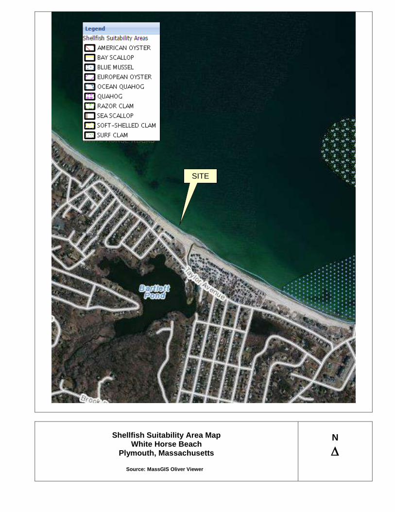
Figure 3: FEMA Map White Horse Beach is located within Land Subject to Coastal Storm Flowage Figure 4: Shellfish Suitability Map The southern portion of White Horse Beach is mapped as Blue Mussell suitability.
The remaining areas are not located within a Shellfish Suitability Area The polygons delineate areas that are believed to be suitable for shellfish
based on the expertise of the Massachusetts Division of Marine Fisheries (MarineFisheries) and local Shellfish Constables, input from commercial fishermen, and information contained in maps and studies of shellfish in Massachusetts.
Figure 5: Shellfish Growing Area Map The White Horse Beach is a prohibited area for shellfish growing.
The Designated Shellfish Growing Area (DSGA) datalayer was compiled by the Department of Fish and Game's (DFG) Division of Marine Fisheries (DMF). Three hundred four growing areas in Massachusetts have been designated by DMF's Shellfish Project.
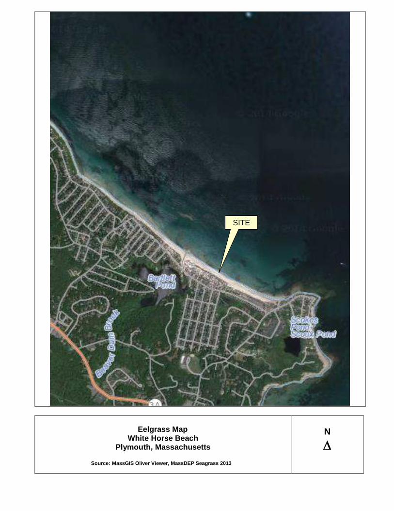
Figure 6: Eelgrass Map The White Horse Beach does not contain mapped Eelgrass.
This map contains features mapped in the fifth phase of the MassDEP Eelgrass Mapping Project. Phase 5 was conducted in 2012 and focused on re-mapping a portion of the Massachusetts Bay and Cape Cod Bay coastline running from the New Hampshire border through the North Shore, Boston Harbor, South Shore and the northern coastline of Cape Cod to Provincetown.

Figure 7: Lobster Harvest 1997 Map The White Horse Beach is within a 500,001 to 1,000,000 pound lobster harvest area.
This map is made up of a datalayer consisting of 25 distinct "statistical reporting areas" covering a large portion of the Gulf of Maine and south, including the territorial waters of the Commonwealth of Massachusetts.
Figure 8: Barrier Beach Map
Portions of White Horse Beach are mapped as Barrier Beaches.
The barrier beach map is made up of a data layer that was compiled by the Resource Mapping Project staff at the University of Massachusetts, Amherst for the Massachusetts Coastal Zone Management Program.
Figure 9: MassDEP Wetlands Map The White Horse Beach is mapped as Coastal Beach, Barrier Beach and Coastal
Dune.
The MassDEP Wetlands Map is made up of a data layer interpreted from 1:12,000 scale, stereo color-infrared (CIR) photography by staff at UMASS Amherst.
Figure 10: ECR GPS Wetland Delineation Map The ECR GPS Wetland Delineation Map delineates the limit of the Coastal
Beach/Coastal Dune interface as mapped in the field by GPS mapping. Figure 11: Town of Plymouth Assessors Maps Figure 12: Public Access Points Map

FIGURE 1

USGS SITE LOCUS MAP
White Horse Beach Plymouth, Massachusetts
Source: MassGIS Oliver Viewer
N
SITE

FIGURE 2

Priority Habitats of Rare Species, Estimated Habitat of Rare Wildlife
& Certified Vernal Pools Map White Horse Beach
Plymouth, Massachusetts
Source: MassGIS Oliver Viewer
N
SITE

FIGURE 3

FEMA MAP
White Horse Beach Plymouth, Massachusetts
Source: FEMA Map 25023C0391J 07/17/2012
N
SITE

FIGURE 4
Shellfish Suitability Area Map White Horse Beach
Plymouth, Massachusetts
Source: MassGIS Oliver Viewer
N
SITE

FIGURE 5

Shellfish Growing Area Map
White Horse Beach Plymouth, Massachusetts
Source: MassGIS Oliver Viewer
N
SITE

FIGURE 6
Eelgrass Map
White Horse Beach Plymouth, Massachusetts
Source: MassGIS Oliver Viewer, MassDEP Seagrass 2013
N
SITE

FIGURE 7

Lobster Harvest Zones
White Horse Beach Plymouth, Massachusetts
Source: MassGIS Oliver Viewer, Lobster Harvest Zones 1997 Overlay
N
SITE

FIGURE 8

Barrier Beach Map
White Horse Beach Plymouth, Massachusetts
Source: MassGIS Oliver Viewer, Barrier Beaches Overlay
N
SITE

FIGURE 9

DEP Wetland Map White Horse Beach
Plymouth, Massachusetts
Source: MassGIS Oliver Viewer, DEP Wetland 12K Overlay
N
SITE

FIGURE 10

ECR GPS Wetland Delineation Map White Horse Beach
Plymouth, MA
Delineated on April 29, 2015
N
∆

FIGURE 11


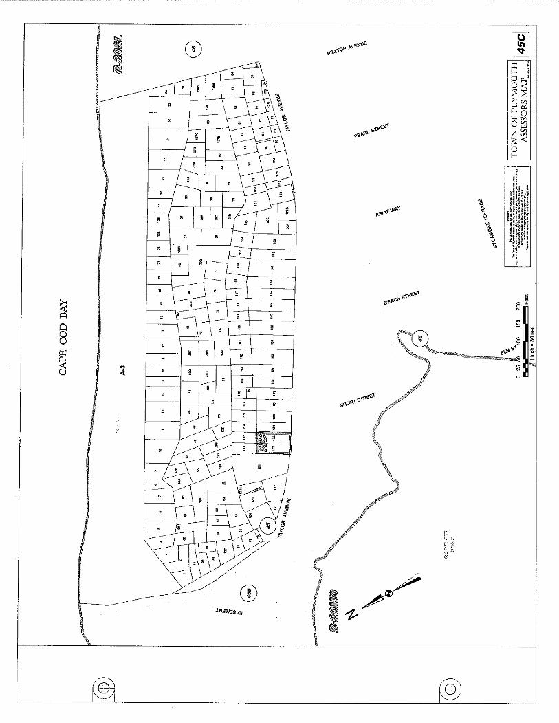


FIGURE 12

Public Access Points White Horse Beach
Plymouth, MA
Source: Google Maps
N
∆

ATTACHMENTS
Attachment 1: Beaches and Parks, Chapter 30 Attachment 2: Site Photograph Pages Attachment 3: Wetland Evaluation Memo with Photograph Pages Attachment 4: Shellfish Survey Attachment 5: American Beach Grass document with planting tips Attachment 6: Plymouth Assessors Property Record Cards for parcels 88F, 88G & 88H Attachment 7: White Horse Beach Parking Committee Final Report Attachment 8: June 23, 2015 Meeting Minutes

ATTACHMENT 1

3001
Chapter 30
BEACHES BEACHES AND PARKS [Amended 5-20-2006 ATM by Art. 33]
§ 30-1. Beach stickers required.
§ 30-2. Motorcycles, minibikes and all-terrain vehicles prohibited; horses restricted.
§ 30-3. Domestic animals.
§ 30-4. Sand dunes and grassy areas.
§ 30-5. Garbage and rubbish.
§ 30-6. Restricted area.
§ 30-7. Parking on private property.
§ 30-8. Speed limit.
§ 30-9. Type of allowed vehicles.
§ 30-10. Camping.
§ 30-11. Glass containers.
§ 30-12. Use of grills and hibachis.
§ 30-13. Open fires.
§ 30-14. Liability.
§ 30-15. Stuck vehicles.
§ 30-16. Riding on outside of vehicle.
§ 30-17. Limitation on number of vehicles.
§ 30-18. Right-of-way to be open.
§ 30-19. Firearms.
§ 30-20. Closing hours.
§ 30-21. Blocking traffic.
§ 30-22. Violations and penalties.
§ 30-23. Parallel parking in certain areas.
§ 30-24. Swimming and bathing. [HISTORY: Adopted by the Annual Town Meeting of the Town of Plymouth 4-16-1974 by Art. 58 as Art. 8 of the 1974 Bylaws. Amendments noted where applicable.]
GENERAL REFERENCES Alcoholic beverages -- See Ch. 18. Animals -- See Ch. 23.

3002
PLYMOUTH CODE § 30-1 Disorderly conduct -- See Ch. 51. Harbor -- See Ch. 81. Noise -- See Ch. 120. Ponds -- See Ch. 134. Solid waste -- See Ch. 157. Vehicles and traffic -- See Ch. 185. § 30-1. Beach stickers required. No persons except property owners, taxpayers and residents of Plymouth and their guests shall be allowed with vehicles on Plymouth Beach north of Manter's Point. All vehicles shall have proper Plymouth Beach stickers. § 30-2. Motorcycles, minibikes and all-terrain vehicles prohibited; horses restricted. No motorcycles, minibikes or minicars or all-terrain vehicles shall be allowed on any public beach. No horses shall be allowed on any public beach between Memorial Day and Labor Day. § 30-3. Domestic animals. [Amended 1-9-1978 STM by Art. 9] All domestic animals on public beaches shall be under control at all times. Dogs are to be leashed in accordance with Chapter 23, Animals, § 23-4A. § 30-4. Sand dunes and grassy areas. [Amended 1-9-1978 STM by Art. 9] No person shall walk or drive any vehicle or wagon or ride a horse on the sand dunes or grassy areas or over any other type of vegetation on all public beaches. Driving is to be on designated trails only. § 30-5. Garbage and rubbish. All persons on any public beach, except owners and occupants of cottages located in Plymouth, must deposit garbage and rubbish in barrels which shall be provided along the beach. Owners and occupants of cottages located in Plymouth shall provide otherwise for the proper disposal of their own garbage and rubbish. § 30-6. Restricted area. [Amended 4-7-1984 ATM by Art. 29] No vehicle shall be allowed to pass on the east side of Plymouth Beach south of the crossover between Memorial Day and Labor Day, except in the case of an emergency or the established rights of Plymouth fishermen.

3003
BEACHES § 30-7 § 30-7. Parking on private property. No vehicles shall be parked on private property on any Plymouth Beach without the consent of that property owner. § 30-8. Speed limit. [Amended 4-7-1986 ATM by Art. 22] No vehicle shall exceed a speed of 10 miles per hour while driving on any portion of any public beach. § 30-9. Type of allowed vehicles. [Amended 1-9-1978 STM by Art. 9] All vehicles driven on Plymouth Beach north of Manter's Point shall be four-wheel-drive vehicles. § 30-10. Camping. [Amended 1-9-1978 STM by Art. 9] Camping on all public beaches shall be restricted to Plymouth residents and Plymouth taxpayers and their guests, but only by a special permit issued by the Park Division. § 30-11. Glass containers. Glass containers of any kind are prohibited from all public beaches. § 30-12. Use of grills and hibachis. All cooking fires from grills, hibachis, etc., shall be properly extinguished. No hot coals shall be left on any public beach. § 30-13. Open fires. No open fires will be allowed on any public beach without a permit from the Fire Department. § 30-14. Liability. All persons using the beach do so at their own risk. § 30-15. Stuck vehicles. [Added 1-9-1978 STM by Art. 9]
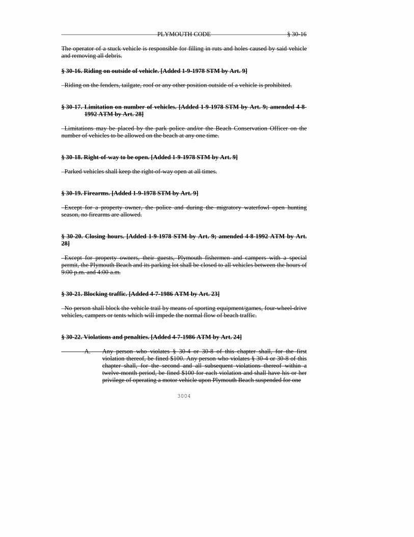
3004
PLYMOUTH CODE § 30-16 The operator of a stuck vehicle is responsible for filling in ruts and holes caused by said vehicle and removing all debris. § 30-16. Riding on outside of vehicle. [Added 1-9-1978 STM by Art. 9] Riding on the fenders, tailgate, roof or any other position outside of a vehicle is prohibited. § 30-17. Limitation on number of vehicles. [Added 1-9-1978 STM by Art. 9; amended 4-8-
1992 ATM by Art. 28] Limitations may be placed by the park police and/or the Beach Conservation Officer on the number of vehicles to be allowed on the beach at any one time. § 30-18. Right-of-way to be open. [Added 1-9-1978 STM by Art. 9] Parked vehicles shall keep the right-of-way open at all times. § 30-19. Firearms. [Added 1-9-1978 STM by Art. 9] Except for a property owner, the police and during the migratory waterfowl open hunting season, no firearms are allowed. § 30-20. Closing hours. [Added 1-9-1978 STM by Art. 9; amended 4-8-1992 ATM by Art. 28] Except for property owners, their guests, Plymouth fishermen and campers with a special permit, the Plymouth Beach and its parking lot shall be closed to all vehicles between the hours of 9:00 p.m. and 4:00 a.m. § 30-21. Blocking traffic. [Added 4-7-1986 ATM by Art. 23] No person shall block the vehicle trail by means of sporting equipment/games, four-wheel-drive vehicles, campers or tents which will impede the normal flow of beach traffic. § 30-22. Violations and penalties. [Added 4-7-1986 ATM by Art. 24] A. Any person who violates § 30-4 or 30-8 of this chapter shall, for the first
violation thereof, be fined $100. Any person who violates § 30-4 or 30-8 of this chapter shall, for the second and all subsequent violations thereof within a twelve-month period, be fined $100 for each violation and shall have his or her privilege of operating a motor vehicle upon Plymouth Beach suspended for one

3005
BEACHES § 30-22 year. B. The owner of any vehicle operated in violation of either § 30-4 or 30-8, whether
said vehicle was operated at the time of said violation by the owner thereof or by another person acting under the authority of or with the consent of the owner thereof, shall be given written notice of every violation of § 30-4 or 30-8 involving said owner's vehicle. The privilege of said owner to have any vehicle of his or hers operated on Plymouth Beach shall be suspended, canceled, revoked or declared forfeited for one year whenever said vehicle shall have been operated in violation of either § 30-4 or 30-8 for a second time within a period of 12 consecutive months.
C. Any person who operates a motor vehicle on Plymouth Beach without an
effective permit for said vehicle or after his or her personal privilege to operate a vehicle on Plymouth Beach has been suspended, canceled, revoked or forfeited, without renewal thereof, shall be subject to arrest for trespass pursuant to MGL c. 266, § 120, as amended.
§ 30-23. Parallel parking in certain areas. [Added 4-5-1989 ATM by Art. 27] All vehicles adjacent to the snow fence, vegetated areas or dune areas must parallel park no less than 15 feet from the frontal dune, unless the area is otherwise designated. § 30-24. Swimming and bathing. [Added 4-22-1991 ATM by Art. 24] A. No person shall bathe or swim in the waters of Plymouth Beach, White Horse
Beach or any coastal waters adjacent thereto or any ponds which are under the jurisdiction of the Town of Plymouth during such time as the lifeguard on duty at said beach determines conditions to be hazardous to the health, safety and welfare of swimmers and bathers. Upon posting of warning signs by the lifeguard on duty or oral notice from the lifeguard that conditions are deemed hazardous, all persons shall exit the water until it is determined that the hazardous condition has abated.
B. Violations of this section shall be punishable by a fine of $50 for each offense. C. This section may be enforced by means of a complaint or noncriminal disposition
under MGL c. 40, § 21D by any police officer of the town. § 30-1. Beach stickers required. Only taxpayers and residents of Plymouth and their guests with proper beach stickers shall be allowed with vehicles on Plymouth Beach north of Manter's Point. All vehicles entering public parks shall have proper stickers or pay the daily entry fee set by the Board of Selectmen.

3006
PLYMOUTH CODE § 30-2 § 30-2. Motorcycles, minibikes and all-terrain vehicles prohibited; horses restricted. No motorcycles, minibikes or minicars or all-terrain vehicles shall be allowed on any public beach or in any park at any time except on designated travelways set by the Park Department. No horses shall be allowed on any public beach or in any public park picnic area between Memorial Day and Labor Day. § 30-3. Domestic animals. All domestic animals on public beaches or parks shall be under control at all times. Dogs are to be leashed and their waste removed and disposed of in accordance with Chapter 23, Dog Control § 23-4 and § 23-14 § 30-4. Sand dunes and grassy areas. Walking or driving is restricted to designated trails and or roads only. No person shall walk, drive any vehicle or ride a horse on the sand dunes or grassy areas or over any other type of vegetation on all public beaches. § 30-5. Dumping and Littering Dumping (the deposit or leaving of household or commercial trash) is prohibited. Littering (the leaving of all other trash except in designated Town receptacles) is also prohibited. Penalty Littering $50 Dumping First Offense $100 Subsequent Offence’s $500 § 30-6. Restricted area. No vehicle shall be allowed to pass on the east side of Plymouth Beach south of the crossover between Memorial Day and Labor Day, except in the case of an emergency or the established rights of Plymouth fishermen. No vehicles are allowed to drive along White Horse Beach except in the case of an emergency or the established rights of Plymouth fishermen or at designated boat launch areas. § 30-7. Parking on private property.
Comment [LFG1]: In my opinion, the deleted section is simply an editorial comment, and not part of the bylaw. Accordingly, I recommend deleting all similar references in the bylaw.
Comment [LFG2]: In my opinion, the penalty provision listed in this section is superfluous given the penalties listed in Section 30-22(a) and (b).

3007
BEACHES AND PARKS § 30-22 No vehicles, other than those owned by the property owner, shall be parked on private property on any Plymouth Beach or parked without the written consent of that property owner. § 30-8. Speed limit. No vehicle shall exceed a speed of 10 miles per hour while driving on any portion of any public beach or park. § 30-9. Type of allowed vehicles. All vehicles driven on Plymouth Beach north of Manter's Point shall be four-wheel-drive vehicles. § 30-10. Overnight Camping. Overnight camping within any Town beach or park is prohibited without a permit issued by the Parks Division, based on policies approved by the Board of Selectmen. Overnight camping on Plymouth Long Beach shall be restricted to Plymouth residents and Plymouth taxpayers and their guests, but only by a permit issued by the Parks Division based on policies approved by the Board of Selectmen. § 30-11. Glass containers. Glass containers of any kind are prohibited from all public beaches and parks. § 30-12. Use of grills and hibachis. Cooking fires contained in grills, hibachis and similar devices is permitted, but only in designated park and beach areas, based on policies approved by Board of Selectmen. All coals must be properly extinguished and may not be left on any public beach or park. § 30-13. Open fires. No open fires (fires not contained in grills, hibachis or similar devices) will be allowed on any public beach or park without permits from both the Park Division and Plymouth Fire Department. § 30-14. Liability. All persons using the public beaches and parks do so at their own risk. § 30-15. Stuck vehicles. The operator of a stuck vehicle is responsible for filling in ruts and holes caused by said vehicle and for removing all related debris from any beach or park.
Comment [LFG3]: See Comment 3
3008
PLYMOUTH CODE § 30-16 § 30-16. Riding on outside of vehicle. Riding on the fenders, tailgate, roof or any other unenclosed exterior portion of any vehicle is prohibited. § 30-17. Limitation on number and parking of vehicles. Limitations may be placed by the Director of Public Works, the Police Chief or the Environmental Technician and their designees on the number of vehicles allowed on any beach or park at any one time or on the location of allowed parking. § 30-18. Right-of-way to be open. Parked vehicles shall keep the pedestrian and vehicular rights-of-way open at all times § 30-19. Hunting and Firearms. No hunting or firearms are allowed within any park or beach except for properly licensed hunters on Town beaches during the migratory waterfowl open hunting season. § 30-20. Closing hours. Town beaches and parks are open from dawn to dusk. Exceptions may be made by policies approved by the Board of Selectmen. Except for private property owners on Plymouth Beach their guests, or fishermen who are residents or taxpayers of Plymouth or overnight campers with the required permit, Plymouth Beach and its parking lot shall be closed to all vehicles between the hours of 9:00 p.m. and 4:00 a.m. § 30-21. Blocking traffic. No person shall block any road or any pedestrian or vehicular trail by means of sporting equipment/games, four-wheel-drive vehicles, campers or other vehicles, or tents which would impede the normal flow of beach or park traffic. § 30-22. Violations and penalties. Unless otherwise specifically provided herein, any person who violates any provision of this chapter shall be subject to the following penalties: First offense $25.00 Second offense $50.00 Third and subsequent $100.00
A. Any person who violates § 30-4 or 30-8 of this chapter shall, for the first violation thereof, be fined $100. Any person who violates § 30-4 or 30-8

3009
BEACHES AND PARKS § 30-22 of this chapter shall, for the second and all subsequent violations thereof
within a twelve-month period, be fined $100 for each violation and shall have his or her privilege of operating a motor vehicle in beaches and parks suspended for one year.
B. In addition to the forgoing 1. The owner of any vehicle operated in violation of either § 30-4 or 30-8,
whether said vehicle was operated at the time of said violation by the owner thereof or by another person acting under the authority of or with the consent of the owner thereof, shall be given written notice of every violation of § 30-4 or 30-8 involving said owner's vehicle. The privilege of said owner to have any vehicle of his or hers operated on beaches and in parks shall be suspended, canceled, revoked or declared forfeited for one year whenever said vehicle shall have been operated in violation of either § 30-4 or 30-8 for a second time within a period of 12 consecutive months.
2. Any person who operates a motor vehicle on beaches or in parks
without an current effective permit for said vehicle or after his or her personal privilege to operate a vehicle on Plymouth Beach has been suspended, canceled, revoked or forfeited, without renewal thereof, shall be subject to arrest for trespass pursuant to MGL c. 266, § 120, as amended.
§ 30-23. Parallel parking in certain areas. All vehicles adjacent to the snow fence, vegetated areas or dune areas must parallel park no less than 15 feet from the frontal dune, unless the area is otherwise designated. § 30-24. Swimming and bathing. A. No person shall bathe or swim in the waters of Plymouth Beach, White
Horse Beach or any coastal waters adjacent thereto or any ponds which are under the jurisdiction of the Town of Plymouth during such time as the lifeguard on duty at said beach determines conditions to be hazardous to the health, safety and welfare of swimmers and bathers. Upon posting of warning signs by the lifeguard on duty or oral notice from the lifeguard that conditions are deemed hazardous, all persons shall exit the water until it is determined that the hazardous condition has abated.
B. Violations of this section shall be punishable by a fine of $50 for each
offense.
A. This section may be enforced by means of a complaint or noncriminal disposition under MGL c. 40, § 21D by any police officer of the town.

ATTACHMENT 2

White Horse Beach Site Photographs
Photograph #1 – View of the beach leading to the dune where users travel into the dune for use as a restroom. Trash is
overflowing the barrel, which is reduced now that Town trash barrels are available.
Photograph #2 – View of the storm impacts causing significant loss of dune.

White Horse Beach Site Photographs
Photograph #3 – Aerial view of the dune system with numerous pathways.
Photograph #4 – Aerial view northwest across the coastal beach. The beach in this section is bordered by a manmade
stone revetment.

ATTACHMENT 3

P.O. Box 1319, Plymouth, Massachusetts 02362 617-529-3792 | www.ecrholmes.com
WETLAND EVALUATION MEMO
TO: Town of Plymouth
FROM: Brad Holmes
DATE: June 10, 2015
RE: White Horse Beach Coastal Dune System ECR performed an analysis of the Coastal Dune system at White Horse Beach on June 10, 2015 to document the existing vegetation. The dune is divided into two sections, which are the front dune facing the ocean and the back dune facing the Taylor Avenue. Please note the following: BACK DUNE Back Dune is vegetated with the following plant species:
Red Cedar (Juniperus virginiana) Black Cherry (Prunus serotina) Bayberry (Myrica pennsylvanica) Poison Ivy (Toxicodendron radicans) Rugosa Rose (Rosa rugosa) American Beach Grass (Ammophila breviligulata) Beach Heather (Hudsonia tomentosa) Beach Pea (Lathyrus japonicas) Seaside Goldenrod (Solidago sempervirens) Crab Apple (Malus spp.) Oriental Bittersweet (Celastrus orbiculatus) Autumn Olive (Elaeagnus umbellate)
The dominant plant species in the Back Dune are Poison Ivy, Bayberry, Rugosa Rose, and Red Cedar. There are minor amounts of non-native invasive plants such as Oriential Bittersweet and Autumn Olive within the Back Dune closer to Taylor Avenue. The removal of non-native invasive plants is recommended. FRONT DUNE Front Dune is vegetated with the following plant species:
American Beachgrass (Ammophila breviligulata) Seaside Goldenrod (Solidago sempervirens) Bayberry (Myrica pennsylvanica) Dusty Miller (Artemisia stelleriana) Beach Pea (Lathyrus japonicas) Poison Ivy (Toxicodendron radicans)
The dominant plant species in the Front Dune are American Beach and Bayberry. For more information, please refer to the photograph pages included with this memo.

White Horse Coastal Dune Site Photographs
Photograph #1 – View across the back dune with Taylor Avenue on the right. Notice Bayberry and Poison Ivy growth
leading to Black Cherry and Red Cedar closer to Taylor Avenue.
Photograph #2 – Another view of the back dune with Taylor Avenue on the left.
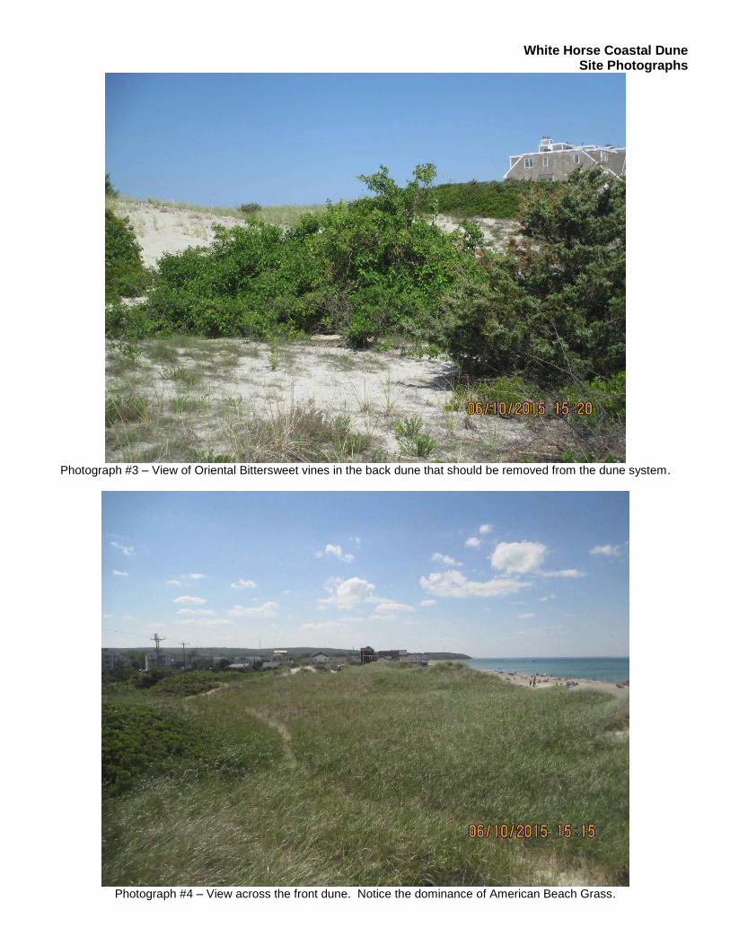
White Horse Coastal Dune Site Photographs
Photograph #3 – View of Oriental Bittersweet vines in the back dune that should be removed from the dune system.
Photograph #4 – View across the front dune. Notice the dominance of American Beach Grass.

White Horse Coastal Dune Site Photographs
Photograph #5 – View of the front dune edge that has eroded due to storm impacts. Dune nourishment and American
Beach Grass planting could restore the dune face.
Photograph #6 – Another view of the front dune edge that has eroded due to storm impacts.

ATTACHMENT 4

P.O. Box 1319, Plymouth, Massachusetts 02362 617-529-3792 | www.ecrholmes.com
Phase 1 Shel lf ish Survey
TO: Town of Plymouth
FROM: Brad Holmes
DATE: May 15, 2015
RE: White Horse Beach – Shellfish Survey
Environmental Consulting and Restoration, LLC performed the first phase of a shellfish survey on May 12,
2015 at White Horse Beach in Manomet (the Site). The purpose of this first phase was to observe shellfish
populations from the Mean Low Water line landward. The weather on May 12th was partly cloudy, warm
(approximately 75 degrees) with wind. During the first phase the following observations were made:
Low tide was at 12:56 pm and -0.02 meters.
No evidence of any shellfish were found (live specimen, siphon holes, etc.)
Less than 10 surf clam shells were found washed ashore
Sand is consistently granular and well drained throughout the beach from Mean Low Water
landward
Looking at MassGIS the southern portion of White Horse Beach contains suitable habitat for Blue
Mussels
Looking at MassGIS this is a prohibited area for growing shellfish
Based on the results of the first phase of the shellfish survey at White Horse Beach on May 12th ECR
concludes that there are no shellfish populating the area from Mean Low Water landward. ECR will conduct
phase two of the shellfish survey at the next extreme low tide.
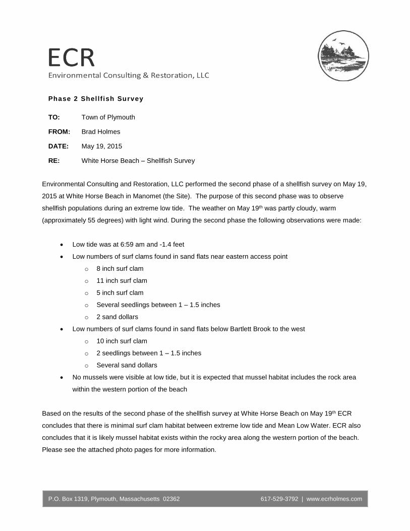
P.O. Box 1319, Plymouth, Massachusetts 02362 617-529-3792 | www.ecrholmes.com
Phase 2 Shel lf ish Survey
TO: Town of Plymouth
FROM: Brad Holmes
DATE: May 19, 2015
RE: White Horse Beach – Shellfish Survey
Environmental Consulting and Restoration, LLC performed the second phase of a shellfish survey on May 19,
2015 at White Horse Beach in Manomet (the Site). The purpose of this second phase was to observe
shellfish populations during an extreme low tide. The weather on May 19th was partly cloudy, warm
(approximately 55 degrees) with light wind. During the second phase the following observations were made:
Low tide was at 6:59 am and -1.4 feet
Low numbers of surf clams found in sand flats near eastern access point
o 8 inch surf clam
o 11 inch surf clam
o 5 inch surf clam
o Several seedlings between 1 – 1.5 inches
o 2 sand dollars
Low numbers of surf clams found in sand flats below Bartlett Brook to the west
o 10 inch surf clam
o 2 seedlings between 1 – 1.5 inches
o Several sand dollars
No mussels were visible at low tide, but it is expected that mussel habitat includes the rock area
within the western portion of the beach
Based on the results of the second phase of the shellfish survey at White Horse Beach on May 19th ECR
concludes that there is minimal surf clam habitat between extreme low tide and Mean Low Water. ECR also
concludes that it is likely mussel habitat exists within the rocky area along the western portion of the beach.
Please see the attached photo pages for more information.

Shellfish Survey, White Horse Beach, Manomet Site Photographs
Photograph #1 – View west down White Horse Beach during an extreme low tide event. Low tide on May 19th was -1.4
feet.
Photograph #2 – View of a surf clam found within the sand flats on the eastern portion of White Horse Beach

Shellfish Survey, White Horse Beach, Manomet Site Photographs
Photograph #3 – An example of one of several seedlings between 1 and 1.5 inches found in the sand flats.
Photograph #4—View of another surf clam found in the sand flats during the extreme low tide on May 19, 2015.

ATTACHMENT 5

Planting Guide
New York
AmericanBeach Grass
IntroductionMaritime beach communities are found above the mean high tide line.Wind erosion and storm waves shape these communities. Plants thatgrow there need to be tolerant of dry and salty conditions and of theconstant burial by shifting sand. The most common plant speciesfound in the maritime beach is American beachgrass (Ammophilabreviligulata). American beachgrass is able to live in this very hot andsalty environment characterized by coarse sand, little organic matterand almost no water. American beachgrass does not only grow on dunesby the ocean, it can be found on beaches along the bays, harbors, andat the base of bluffs along Long Island Sound. Given its dense rootstructure and ability to grow through accreting sand, Americanbeachgrass helps in the formation of dunes. Dunes play a very importantrole in protecting the coast, by buffering incoming waves. AlthoughAmerican beachgrass is adapted to life in a tough environment, it can notwithstand people walking on it. Once the American beachgrass starts todie off, the stability of the dune is threatened. Dunes are also affected bynatural forces such as storms and floods. Planting American beachgrasscan restore damaged dune systems.
American BeachgrassCharacteristics
American beachgrass has a range that extendsfrom New England to North Carolina. It hasthe ability to continue to grow even as natureburies it with sand. As the grass capturessand that winds blow across it, dunesare built. The grass responds to beingburied by sending up a new rhizome(underground stem). From the new rhizome,a new shoot forms. The rhizomes alsohelp the plant spread horizontally upto 6'-10' annually. American beachgrassgrows up to 2'-3' tall. The plant doesproduce a seedhead and seeds, but muchof the spreading is through the rhizomes.Seedlings have a tough time gettingestablished in a hot, dry environment.
New York’s Sea GrantExtension Program
provides Equal Programand Equal Employment
Opportunities inassociation with CornellCooperative Extension,
U.S. Department ofAgriculture and U.S.
Department ofCommerce and
cooperating CountyCooperative Extension
Associations.
Americanbeachgrassgrows to2’-3’ tall
and
CornellCooperativeExtension of
Suffolk County
MarineProgram

AmericanBeach GrassPlanting TipsAmerican beachgrass comes in more than one variety. The varietyrecommended by the United States Department of AgricultureNatural Resources Conservation Service for our area is called “Cape.”Some Long Island nurseries are propagating beach grass from ourLong Island dunes. Some groups feel it is better to use beachgrassfrom this local source. The United States Department of AgricultureNatural Resources Conservation Service offers this advice:
1. Plant strips of beachgrass parallel to the coastline.It is easily done by hand. The row closest to the oceanshould be at least 100' above the mean high tide line.Along the ocean, if space permits, plant a 40'-50' widestrip, but no less than 20', and 10 rows deep. Thispermits the planting to trap blowing sand, and to builda dune.
2. American beachgrass can be planted from October 15thto March 31st in the Mid-Atlantic, as long as the sandis not frozen.
3. Plants and roots must be kept moist before and duringplanting. Try using wet burlap. On most sites, therecommended plant spacing within a row is 18". Whereerosion is severe, decrease the spacing to 12" apart.
4. Plant two 18"-24" stems in a hole, approximately 7"-9" deep.5. Stagger the rows. An 18' by 18' spacing requires 38,000 culms
or stems per acre, or 889 culms per 1,000 square feet.6. Compact the sand firmly around the plants.7. Beachgrass should be fertilized. Broadcast fertilizer over
the planting at a rate equivalent to 1.4 pounds per 1,000square feet. Fertilizer should be applied 30 days afterthe planting date, but not before April 1st.
8. Protect your new planting from foot/vehicle traffic byplacing snow fencing around it.
Plan
ting
Gui
de
Americanbeachgrass is easily
planted by hand.
and
CornellCooperativeExtension of
Suffolk County
Marine Program
New York
ObtainingHelp
It’s a good idea to obtainsome professional advicebefore implementing abeach grass planting.Good sources of help are:
Cornell CooperativeExtension ofSuffolk CountyMarine Program,3690 Cedar Beach Rd.,Southold NY 11971516-852-8660
New York Sea GrantExtension Program,3059 Sound Ave.,Riverhead, NY 11901516-727-3910
USDA Natural ResourcesConservation Service,Riverhead County Ctr.,Room N-210,Riverhead, NY 11901516-727-2315
These three organizationscan also help you locatesources of Americanbeachgrass plants.
Step 1 Step 2 Step 3

ATTACHMENT 6


ATTACHMENT 7

1
WWHHIITTEE HHOORRSSEE BBEEAACCHH PPAARRKKIINNGG CCOOMMMMIITTTTEEEE FINAL REPORT
TTOOWWNN OOFF PPLLYYMMOOUUTTHH
SSEEPPTTEEMMBBEERR 22001133

WHITE HORSE BEACH PARKING COMMITTEE FINAL REPORT
2
TABLE OF CONTENTS
Introduction ..................................................................................... 3 White Horse Beach Parking Committee .............................. 3 Committee Charge ............................................................... 4 Acknowledgments ............................................................... 5
Executive Summary ......................................................................... 6 Existing Conditions Study area ........................................................................... 7 Demographics & Growth Patterns ...................................... 8
Estimated Parking Demand .............................................. 12 Brainstorming of Issues and Prioritization .................................... 17 Problem Summary and Goals Statement ....................................... 18 Public Involvement……………………………………………… 19 Information from other agencies ................................................... 20
Police and Fire .................................................................. 20 Department of Public Works ............................................ 21 Park Plymouth .................................................................. 21
Destination Plymouth & Chamber of Commerce.......................... 21 Information from other communities ............................................ 22 Ideas for Solutions and Prioritization ............................................ 25 Implementation Strategies ............................................................. 26 Appendices ................................................................................... 31

WHITE HORSE BEACH PARKING COMMITTEE FINAL REPORT
3
INTRODUCTION
In the Fall of 2012, the Board of Selectmen initiated the process of reviewing the seasonal parking situation at White Horse Beach. The Selectmen created a short-term Committee consisting of nine members as follows: 1 Natural Resources & Coastal Beaches Committee designee 1 East White Horse Beach Representative 1 Manomet Height Association Representative 1 Sands of White Horse Beach Association Representative 1 Ocean Point Condominium Representative 1 White Horse Beach Representative 1 Manomet Village Steering Committee Representative 1 Priscilla Beach Association Representative 1 Member at Large The White Horse Beach neighborhood consists of many associations each stakeholder group was represented on the committee.
THE WHITE HORSE BEACH PARKING GUIDING TEAM Dawn Dillon (Chair) ......................................... ……………East White Horse Beach Association
Christine Bostek (Vice-Chair). ..………….……………Sands at White Horse Beach Association
Peg O’Hearn .................................................................................. Manomet Heights Association
John Vacha ............................................................................... …White Horse Beach Association
Cheryl Damiano ................................................................................................... Member at Large
Linda Evans ............................................... Manomet Village Steering Committee Representative
Tim Bennett ......................................................................................... Priscilla Beach Association
Jan Zabriskie ........................................................................................ Ocean Point Condominium
Peter Denehy ......................................................... Natural Resources Beach Committee Designee

WHITE HORSE BEACH PARKING COMMITTEE FINAL REPORT
4
COMMITTEE CHARGE
General Mission: The Town of Plymouth recognizes the requests of White Horse Beach residents to assist in adequately controlling parking in the White Horse Beach area, particularly in the summer months. Problems of inadequate residential parking, competing visitor parking, and parking in areas that are causing concerns and frustrations are escalating. The White Horse Beach Parking Committee shall research parking plans in coastal areas with cluster development, and shall develop possible strategies to mitigate or improve the seasonal parking situation. Objectives: The White Horse Beach Parking Committee shall put together a proposal for the White Horse Beach area in and around Taylor Avenue that will provide parking for taxpayers in the area, visitors to the area, and residents of the area. The proposal shall include an assessment, a plan for implementation, a timeline, enforcement procedures, administrative procedures, any staffing needs and a projected revenues/expenditure pro forma budget, as well as other ancillary details. The proposal will consider the development, management, and operation of on and off-street parking, as well as any structured parking (public lots or private lots), directional in informational signage, transit services (i.e. shuttle), and other parking needs that will balance residential and visitor needs. Logistics: Deadline for recommendation set for July or August of 2013 (keeping in mind that if there are
town meeting requests, those deadlines should also be accommodated) Study other towns that have successfully implemented successful parking programs in similar
areas – successful designed as balancing residential and visitor needs Establish a report of recommendations to present to the Board of Selectmen, including an
implementation plan and schedule The Selectmen may periodically ask the Committee to provide an update on their progress at a
Selectmen’s meeting The Committee shall do outreach to as many residents in the area as possible, including one
public hearing. Report required to the Town Clerk 30 days before Annual Town Meeting

WHITE HORSE BEACH PARKING COMMITTEE FINAL REPORT
5
ACKNOWLEDGEMENTS The White Horse Beach Parking Committee would like to thank everyone who supported and continue to encourage our effort; this document is better for their input. The Committee is grateful to the following for providing staff support for the committee:
Elizabeth Sullivan, Special Assistant to the Town Manager Valerie Massard, AICP, Senior Planner
Thank you to the following individuals who also gave their time to meet with the Committee as guest speakers providing technical expertise and suggestions:
Lee Hartmann, AICP, Director of Planning & Development
Denis Hanks, Executive Director Plymouth Chamber of Commerce Paul Cripps, Executive Director Destination Plymouth John Burke, Director Park Plymouth Jonathan Beder, Director of Public Works Michael Botieri, Chief of Police Sid Kashi, PE, Town Engineer

WHITE HORSE BEACH PARKING COMMITTEE FINAL REPORT
6
EXECUTIVE SUMMARY
In order to study the problems of inadequate residential parking, competing visitor parking, and parking in this area the Board of Selectmen created the short-term White Horse Beach Parking Committee. Under the required charge, the Committee held bi-monthly open public sessions meeting a total 14 times over the last seven months. All meetings were posted and open to the public and included a public brainstorming session as well as public forum with the Manomet Village Steering Committee, held on July 25, 2013. This Plan and recommendations are intended to serve as a foundation for the future policy setting for parking in the White Horse Beach study area. Recommended strategies include short, mid and long-term parking improvements and programs. The Plan was prepared with staff support using previous studies, residents, public input, and the technical expertise of many guest speakers. Early on the Committee held a brainstorming session, which was well attended by many citizens of Plymouth and including residents of the White Horse Beach neighborhood. Through this session, the Committee set their priorities and goals, which helped to guide the Committee and will continue to serve as principles for the future management of parking in the area. Key strategic and operational issues are identified that must be addressed in order to mitigate the parking conditions for residents, citizens of Plymouth and tourists. White Horse Beach is a public beach with no designated public parking. Through this process the Committee struggled at times because there is a lack of vision for this public natural resource. Implementation of any kind will require policy makers to develop a vision for White Horse Beach, engage stakeholders in both the White Horse beach neighborhood as well as residents throughout Plymouth, and finally generate a consensus on potential strategies for this area. The White Horse Beach parking Report is intended to act as a guide for public policy decisions and investments for the area studied. These recommended improvements must in all cases support the approved Taylor Avenue Reconstruction Plan initiatives and be consistent with the Committee’s goals which serve as guiding principles for future decision-making.
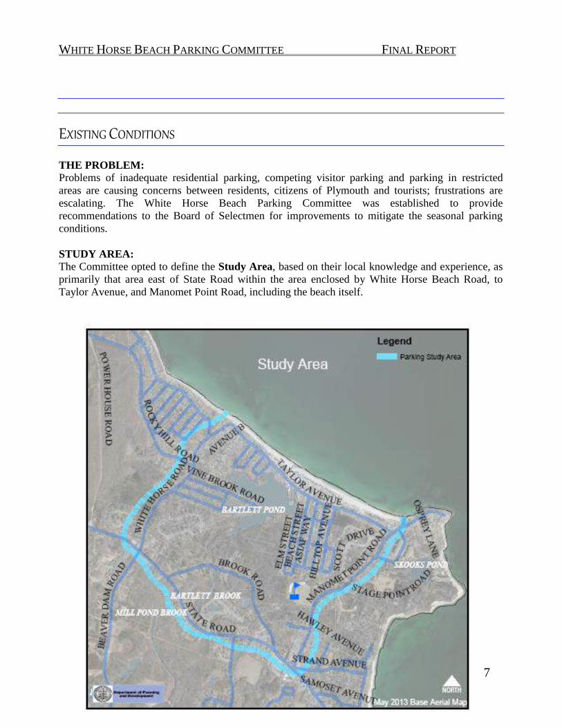
WHITE HORSE BEACH PARKING COMMITTEE FINAL REPORT
7
EXISTING CONDITIONS THE PROBLEM: Problems of inadequate residential parking, competing visitor parking and parking in restricted areas are causing concerns between residents, citizens of Plymouth and tourists; frustrations are escalating. The White Horse Beach Parking Committee was established to provide recommendations to the Board of Selectmen for improvements to mitigate the seasonal parking conditions. STUDY AREA: The Committee opted to define the Study Area, based on their local knowledge and experience, as primarily that area east of State Road within the area enclosed by White Horse Beach Road, to Taylor Avenue, and Manomet Point Road, including the beach itself.

WHITE HORSE BEACH PARKING COMMITTEE FINAL REPORT
8
ORIGINS OF WHITE HORSE BEACH White Horse Beach has always been a sandy coastline, widening out west of Manomet Point in a beach-level setting where access from land is not obstructed by coastal bluffs. A colored decade map using year-built data from the Assessor records was generated on the Town’s GIS system, below, to provide a perspective on
the development trends in the Study Area through 1950. While used for recreation, there was no substantial development of beach colonies or recreational beachfront until the early to mid-1900s. Brief History of Settlement in the study area. The following is based upon the Public Archaeology Lab’s Town of Plymouth Narrative History Comprehensive Survey, Phase IV, 1997, with some added information by the Planning Office1.
Archaeological evidence suggests that Wampanoag tribes lived near the coast during warm months, planting corn, beans, and squash, and fishing from the ocean and streams. The Wampanoag were part of a larger confederation of Native Americans who lived throughout southeastern Massachusetts. A network of trails connected the Plymouth-area residents to communities north, west and south. Just prior to the permanent settlement by the English, the Wampanoag people endured three epidemics, which destroyed the local population, in some cases wiping out entire villages.
The Pilgrims arrived in 1620 on the Mayflower, settling in Plymouth at the mouth of spring-fed Town Brook, where it empties into the ocean at Plymouth Harbor, initiating the European settlement of the area. The existing paths running north and south along the coast were still present and used by travelers heading from Sandwich to Plymouth (Old Sandwich Road). Robert Bartlett, a passenger on the Mayflower, was one of the first to build a house on what is now Brook Road in 1660, although this house was badly damaged in a fire in the late 1990s. For most of its history, Manomet has been relatively isolated from the rest of Plymouth due to the physical barrier created by the Pine Hills.
Farmers began building houses in Manomet south of the Pine Hills in the seventeenth century and by 1739, the area had enough families to support its own church, the Second Church of Plymouth Congregational. The original burial ground for this church, White Horse Cemetery, still exists, but the original church building was replaced in 1826 with a new building. In the late 1700s, fishermen and shipbuilders began moving to the coastal area at the base of Plymouth Beach near Eel River. David Manter was one of the first fisherman to locate on the point, and he was followed by other seamen, carpenters, and farmers. Travel to Plymouth was by method of boat, or over the Pine Hills walking, horseback or horse and carriage. By the end of the 1700s, Assessor’s records show two
developed parcels in or near the study area.
1 Town of Plymouth Narrative History Comprehensive Survey, Phase IV, 1997.
Photo credit: Plimoth Plantation.

WHITE HORSE BEACH PARKING COMMITTEE FINAL REPORT
9
Excerpt 1903 map Mapsofantiquity.com
The development of Wellingsley [the area situated by Wellingsley Brook north of Manomet] and Manomet to the south was facilitated by the construction of rail lines in the late nineteenth century. The Old Colony Railroad first linked Plymouth and Boston in 1845, and the development of the coastal areas of Plymouth was spurred by the construction in 1889 of an electric streetcar which traveled from Kingston through Plymouth Center and along Sandwich Street, Warren Avenue, and Rocky Hill Road to the Manomet Shore. Using Assessor’s records, approximately 50 developed parcels were scattered in all of Manomet Village at the turn of the century, and there were 4 developed parcels in the study area.
By 1910, the first two beach cottages on White Horse Beach are developed, according to Assessor records. Other cottages located to the north of Bartlett Pond but not on the beach are also springing up, and a few developed parcels are shown near Fisherman’s Landing at the
end of White Horse Beach. There are also two developed parcels on the south edge of Bartlett Pond.
Development in the area accelerated rapidly at the turn of the twentieth century when transportation routes were extended
through the Pine Hills. These included the State Road, the State Highway, and the electric rail line. The new roads and electric rail helped transform Manomet into a summer resort community. Developers built large homes and hotels on Manomet Bluffs and Manomet Point, while smaller-scale cottages were built in the area around White Horse Beach.
White Horse Beach was itself established as a public beach in 1917 with the transfer of land to the town. The adjacent Priscilla Beach was developed ten years later, on a portion of the old Taylor Farm. The trolley lines were abandoned in the 1920s. By 1920, two more cottages on White Horse Beach are shown.
In the 1930s and 1940s, Priscilla Beach was an attractive destination for famous actors who often performed at the Priscilla Beach Theater and stayed in surrounding homes.
The White Horse Beach sand cottage community expanded in the 1930s, when there were 27 beach cottages, through the 1950s to over 100 cottages on White Horse Beach and its dunes. In that same time period, north of Bartlett Brook, 14 developed parcels exist within the dunes in 1920, increasing by four beach cottages by 1950, although roughly 200 parcels in and around Priscilla Beach (but not on the physical beach) have been built. By 1950, nine parcels are developed on the hill on the west side of White Horse Beach, and a handful of developed parcels have grown up around the original homes on the south end of Bartlett Pond.

WHITE HORSE BEACH PARKING COMMITTEE FINAL REPORT
10
Credit Boston Globe House in Scituate http://www.blizzardof78.org/south-shore.php
In 1960, Priscilla Beach development is scattered infill near existing pockets of previously developed land. Many of the formerly undeveloped land on the south of Bartlett Pond (opposite White Horse Beach) have been developed, and the stretch of the west side of Taylor Avenue from what is now Hilltop Avenue towards Fisherman’s Landing is developed. The east side of Bartlett
Pond and other parts of its shore are becoming settled. By the 1970s another twenty-two beach cottages are added to White Horse Beach, and a new subdivision is built on the north end of Bartlett
Pond, with additional development near what is now the Manomet Elementary School (constructed in 1960). The Blizzard of 1978 caused some significant damage to White Horse Beach2, and homes were reconstructed, as they have been from time to time due to fire or storm damage. In the 1980s and 1990s, residential development is primarily closer to State road and around the elementary school, although a handful of beach homes and residences are built near the south end of Bartlett
Pond. Another subdivision is built between the White Horse Cemetery and Bartlett Pond. In the 2000s, previously undeveloped beach and older neighborhood lots are developed as infill, and home conversions to year-round homes are more common, as there is little land available for new construction.
2 Blizzard of ’78 Coastal Storm Damage Study, Prepared by the New England Division of the USACE, February 1979.

WHITE HORSE BEACH PARKING COMMITTEE FINAL REPORT
11

WHITE HORSE BEACH PARKING COMMITTEE FINAL REPORT
12

WHITE HORSE BEACH PARKING COMMITTEE FINAL REPORT
13
ESTIMATED PARKING DEMAND ASSESSMENT
Off-Season Parking
After examining the study area in the field and using aerial views, an estimated 110 cottages located on the beach and dunes do not have parking spaces visibly associated with the residence. An aerial inspection found that the rest of the dwellings within the study area appear to have on-site driveway parking or are adjacent to private or public parking lots that front on Taylor Avenue.3
In 1976, regional policy projected future growing demands on public beaches, directing planners to design satellite parking off the Route 3 interchange. In response to an inquiry by a local resident in 1976 regarding parking in the White Horse Beach Area, the Selectmen asked the Parking and Traffic Study Committee to examine parking needs in the study area, with input from the Planning Director, Town Engineer and Chief of Police at that time4. Two undeveloped privately owned parcels in the area were identified, as possible sites with a yield of roughly 100 parking spaces if acquired for such purposes however, this did not proceed. Board of Selectmen acted to create on-street parking as a result of that study.
See Map on following page.
3 It has not yet been determined why the beach residents who lack frontage/parking do not park on the beach next to their dwellings, or when the ability to park on the beach next to their dwellings was eliminated. 4 White Horse Beach: Use, Traffic and Parking, consisting of compiled memorandums and data, dated October 18, 1976 by Planning Board Staff, received by the Selectmen November 2, 1976.

WHITE HORSE BEACH PARKING COMMITTEE FINAL REPORT
14

WHITE HORSE BEACH PARKING COMMITTEE FINAL REPORT
15
Not much has changed since the on street parking was created. According to a GIS Map created by Planning Staff (using the Board of Selectmen Traffic Rules and Orders, with input from DPW Engineering staff), the available public on-street parking, after accounting for driveways, crosswalks, hydrant buffers and intersection buffers required under the Traffic Rules and Orders, parking for a size of 10’x18’ on a portion of Taylor Avenue is 68 spaces and Hilltop Avenue is 31 spaces. The Town also has an off-street parking lot on Taylor Avenue that can accommodate roughly 25 vehicles. The Selectmen also created room for approximately 9 recognized spaces near Fisherman’s Landing. In total,
133 public available parking spaces were created.5 Taylor Avenue reconstruction plans will result in an estimated 69 on-street parking spaces, or a net increase of 1 space, to 134.
Broadly, we know from the Census and Assessor information that approximately 50% of the homes in the study area are owner-occupied year-round residences. Current zoning requires that a new single family dwelling to have two parking spaces (such as in a driveway or garage). This translates to 220 private parking spaces which would have to be created on the properties of these private beach cottages if they were built under today’s requirements. Looking at off-season use, there is a demand for 110 spaces for seasonal residential use to support the private residents in the study area, assuming no use of the rental or second-homes year-round. The public parking already available satisfies that number, not accounting for the informal parking arrangements already in existence in the area.
5Additional on-street parking was also created in the Priscilla Beach vicinity around the same time, which for discussion purposes is considered too far from the public beach for inclusion.

WHITE HORSE BEACH PARKING COMMITTEE FINAL REPORT
16
Seasonal Parking
The Police, Committee and guidance from the Board of Selectmen indicate that summer weekends are the most high-demand parking times for the study area. Estimates for seasonal parking demands are based on the following:
In 2012, the seasonal population of Plymouth, as estimated by the Town Clerk, was 85,191.6 The Town Planning Office estimates that the year-round population of Plymouth in 2012 was 56,794, so tourism represents a rough percentage increase in population of about 50% annually.
The year-round population of the Study Area, based on the 2010 US Census, is 1719 people. Using the estimated increase in population during peak season above and applying it to the area of this study an estimated increase of 860 seasonal users can be expected in the Study Area. For the purposes of this study we know there are private residences in the study area as well. is a rough estimate. We estimate that the private residences on the dunes and beach area that are seasonal users have a demand of approximately 86 seasonal parking spaces to serve the demand of these residents.
Using the Census data, we can estimate, again based on the seasonal tourism increase town-
wide, 860 visiting population seasonally for the Study Area. Using an estimate of 2 visitors per vehicle, or 375 visitor parking spaces represent the highest demand. Statements from the Committee members and Police indicate that the 4th of July weekend is this high-demand event. Applying the 80-20 Pareto principal for planning purposes, 80% of the time only 20% of these spaces reflect demand for a typical summer weekend – or 86 visitor spaces.
The two seasonal users taken together thus leave the area with an estimated shortfall of 151 parking spaces. In comparison, the Manomet Elementary School has roughly 55 parking spaces. A commercial parking lot of approximately the same scale was used by Planning Staff to estimate land area for 225 spaces, which is about 1.75 to 2 acres accounting for travel and turning lanes within a parking lot, which adjusts for safety, liability, or other events which may occur in or around the parking lot.
6 Selectmen’s vote of seasonal population, December 11, 2012.

WHITE HORSE BEACH PARKING COMMITTEE FINAL REPORT
17
Assessment Summary Off-season demand: As noted previously, 25 years ago the Town Selectmen created 118 additional on-street parking spaces in the Study Area. To this day this additional parking remains adequate for the off-season demand. Seasonal demand: Appears to be between 150 - 200 parking spaces. Almost all of the nearby land has been developed now, with the exception of one large private undeveloped parcel which may be developed in the future.
Seasonal Parking Space Demand Estimates Estimated Parking Space Estimated Gap in Available Demand On-Street Parking Spaces
Off-Season only spaces 110 0 (23 extra*) Summer Season: Estimated added Seasonal Private Residence spaces 76 -53 Estimated added Average Seasonal Weekend visitor spaces 75 -75 Total Average Added Seasonal Demand (weekend) Spaces 151 -128 Estimated Peak Demand (4th July) 561 -428 (110 year-rounder + 76 seasonal residence + 375 visitor spaces)
*Existing on-street parking is 133 spaces
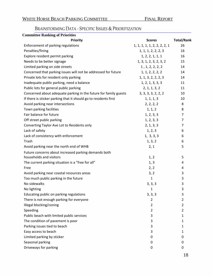
WHITE HORSE BEACH PARKING COMMITTEE FINAL REPORT
18
BRAINSTORMING DATA - SPECIFIC ISSUES & PRIORITIZATION Committee Ranking of Priorities
Priority Scores Total/Rank
Enforcement of parking regulations 1, 1, 1, 1, 1, 2, 2, 2, 2, 1 26
Penalties/fining 1, 1, 1, 2, 2, 2, 3 16
Explore resident permit parking 1, 2, 2, 1, 1, 1 16
Needs to be better signage 1, 3, 1, 2, 3, 2, 3, 2 15
Limited parking on side streets 1 , 1, 2, 2, 2, 2 14
Concerned that parking issues will not be addressed for future 1, 1, 2, 2, 2, 2 14
Private lots for resident only parking 1, 1, 3, 2, 2, 2, 3 14
Inadequate public parking, need a balance 1, 2, 1, 3, 3, 3 11
Public lots for general public parking 2, 1, 1, 3, 2 11
Concerned about adequate parking in the future for family guests 3, 3, 3, 3, 2, 2, 2 10
If there is sticker parking that it should go to residents first 1, 1, 1, 3 10
Avoid parking near intersections 2, 2, 2, 2 8
Town parking facilities 1, 1, 2 8
Fair balance for future 1, 2, 3, 3 7
Off street public parking 1, 2, 3, 3 7
Converting Taylor Ave Lot to Residents only 2, 1, 3, 3 7
Lack of safety 1, 2, 3 6
Lack of consistency with enforcement 1, 3, 3, 3 6
Trash 1, 3, 2 6
Avoid parking near the north end of WHB 2, 1 5
Future concerns about increased parking demands both households and visitors 1, 2 5
The current parking situation is a "free for all" 1, 3 4
Free 2, 2 4
Avoid parking near coastal resources areas 3, 2 3
Too much public parking in the future 1 3
No sidewalks 3, 3, 3 3
No lighting 1 3
Educating public on parking regulations 3, 3, 3 3
There is not enough parking for everyone 2 2
Illegal blocking/coning 2 2
Speeding 2 2
Public beach with limited public services 3 1
The condition of pavement is poor 3 1
Parking issues tied to beach 3 1
Easy access to beach 3 1
Limited parking by sticker 0 0
Seasonal parking 0 0
Driveways for parking 0 0

WHITE HORSE BEACH PARKING COMMITTEE FINAL REPORT
19
68
6768
23 28
Grouped Priority Rankings
Priority Parking for Residents & Guests
"Fair Balance" between Resident and Public Parking
Lack of Enforcement/Legal Signage
Safety Concerns
Other
GOALS STATEMENT
BASED ON THE RANKED PRIORITIES THE COMMITTEE CREATED THE FOLLOWING GOALS: 1. Provide a balanced approach, with an emphasis on area residents that improves parking at White Horse Beach for residents and visitors.
2. Improved enforcement and education of parking rules and regulations. 3. Enhance safety for pedestrians bicycle and vehicles associated with parking and traffic circulation.

WHITE HORSE BEACH PARKING COMMITTEE FINAL REPORT
20
PUBLIC INVOLVEMENT FORUM The White Horse Beach Parking Committee held 14 bi-monthly regularly scheduled public meetings. One of these meetings was a brainstorming session where the Committee generated goals. The priorities and goals were set based on both the Committee and stakeholder input received during the brainstorming session. In addition, in coordination with the Manomet Village Steering Committee the Committee held one public forum. On July 25, 2013 the White Horse Beach Parking Committee presented their draft findings and solicited public input on the various parking ideas researched by the Committee to date. The meeting was be hosted by the Manomet Village Steering Committee. Immediately following the presentation, the Committee was available for questions. The Forum was well attended and many residents from the White Horse Beach area offered public comment. Feedback ranged from leaving things “status quo”, to opposition of some of the recommended strategies, and further, offering additional alternatives for the area. The Manomet Village Steering Committee recorded in their minutes that the meeting was attended by more than 102 individuals and many of them took the time to stand up and express their opinions on the findings and proposals presented at the meeting. At the end of the public forum portion of the meeting the Chair of the Manomet Village Steering Committee asked the public to participate in an ad hoc straw poll. The five questions and results were as follows:
1) Improved Legal Signage and Enforcement – Majority in Favor 2) Increased Parking Violation Fines – Majority in Favor 3) Parking along Dunes – Majority Opposed 4) Satellite Parking – appeared to be a 50/50 split 5) A Permit Parking Program – Majority Opposed
A full record of the Manomet Village Steering Committee Minutes are included in the appendix. Other Concepts suggested which were not included in the Committees research included: Off Road Beach Parking – drive on beach parking, this is done presently Long Beach Setting up a revolving fund for White Horse Beach Consultant funding for Parking Study The White Horse Beach Parking and Manomet Village Steering Committees organized the educational event to provide residents with an opportunity to hear and make public comment on the parking concepts suggested by the Committee. The meeting was public and all interested residents/citizens were encouraged to attend and offer comments.

WHITE HORSE BEACH PARKING COMMITTEE FINAL REPORT
21
INFORMATION FROM OTHER AGENCIES POLICE CHIEF - SUMMARY The Police Department enforces signage authorized by the Board of Selectmen, including signage on private roads with plans approved by the Selectmen. The Parking and Traffic Task Force Committee, which includes a Police Captain, representatives Department of Public Works and Board of Selectmen, reviews signage, marking complaints and suggestions. Recommendations to the Selectmen go through this committee. Examples of infrastructure and signage that are less successful include speed bumps (or speed “humps,” which are wider). Examples of successful ideas include those already used in regulations enforced
by the Police Department. The Committee asked about municipal stickered parking, and the Chief cautioned the committee against creating a situation that could lead to unintended consequences. Chief Botieri noted that Park Plymouth is a private corporation that enforces parking downtown within a specific area, they generate the revenue and the town collects a percentage. The Chief recommends that the Committee look at whether higher fines for parking violations might be a reasonable approach. A vehicle many not park in front of a driveway and must be ten (10) feet from a fire hydrant. The Police can help in situations that are not in regulations, depending on the situation, but will only tow a vehicle if there is an issue with public safety. Chief Botieri stressed that if people are calling the Police and feel that they are not adequately responsive, to let him know. There is someone assigned year-round to Manomet, however, the number one priority is response to 911 calls. The business line is for non-emergency calls such as parking. Chief Botieri then made a point to provide the non-emergency line to the Committee and everyone in attendance. TOWN ENGINEER, DEPARTMENT OF PUBLIC WORKS - SUMMARY Mr. Sid Kashi, Town Engineer, gave an overview of the proposed Taylor Avenue reconstruction project – a locally administered project which will be funded by that State. The first outreach meeting on this project was in 2005 when a notice was sent to all White Horse Beach residents. The Taylor Avenue reconstruction project is part of Transportation Improvement Program (TIP). Mr. Kashi stated that presently, the Town is waiting to get a commitment letter from the State on the funding to do the improvements. A criterion of state is to have local support from Board of Selectmen, residents and the community, and further that the project accommodates pedestrians and bicyclists. The Samoset Street and Obery Street projects are examples of TIP-funded projects in Plymouth. The Committee asked whether there may be an opportunity within (or in front of) the Town-owned dunes to create parking in a small area along Taylor Avenue. A Bond Bill for the Taylor Avenue Project is earmarked, and the plans are at 75% design. There are some aspects, such as new utilities or work outside of the road layout, which the state will not pay for. State design guidelines must be met for state funding. Sid commented that the Town does not fund any road projects, Chapter 90 does, and legislators need to bond the project. Sid suggested the Committee send a letter of support to the Secretary of Transportation. Once funding is secured, the project will go to the regional planning agency, Old Colony Planning Council. At the request of the Parking Committee, a discussion was held between DPW Director Jonathan Beder and Sid Kashi. Mr. Beder authorized the angled parking concept offered by the Committee for consideration to be added to the 100% design plans for possible angled parking at White Horse Beach along Taylor Avenue by the public beach entrance, allowing it to be constructed with or before the Taylor Avenue reconstruction. A follow up report was received from Fay, Spofford and Thorndyke, the firm charged with the design on behalf

WHITE HORSE BEACH PARKING COMMITTEE FINAL REPORT
22
TOWN ENGINEER, DEPARTMENT OF PUBLIC WORKS - SUMMARY of the Town, showing a conceptual plan and summarizing a series of permitting challenges that would have to be overcome in order to implement the concept. If the Town prepared the area as a gravel pad, there would be minimal construction costs, but permitting could be expensive and time-consuming. The feasibility of permitting parking along the dunes would need to be explored further. The Taylor Ave Transportation Improvement Project/TIP may be in future 2018-2020 TIP. PARK PLYMOUTH - SUMMARY John Burke, Park Plymouth explained that the Town needs to have a vision for the White Horse Beach as far as, who we are hoping to attract to the area - for example, tourists? Plymouth residents only? Residents of White Horse beach only? If the general public or all Plymouth residents are sought then there will need to be vastly more public parking accommodations that could be costly and necessitate charging or raising fees on parking/beach access. Mr. Burke stated that a resident’s only parking program is more exclusive and more
involved with regard to program enforcement, signage/striping and administration. According to Mr. Burke, any resident parking program would need to take into account the parking demand for private homes in the area, rentals and visitors. John indicated that if a residential parking program in a beach area was desired, we may want to look at other coastal communities that are doing this already such as Newburyport, MA or Newport, RI. He stated that any expansion of Park Plymouth's defined Downtown, Waterfront and North Plymouth parking district would require authorization from the PGDC Board of Directors as well as the Plymouth Board of Selectmen. PLYMOUTH AREA CHAMBER OF COMMERCE & DESTINATION PLYMOUTH - SUMMARY Denis Hanks, Executive Director for Plymouth Area Chamber of Commerce gave an overview of Chamber activities for tourism. Mr. Hanks stated that the Chamber advertises Plymouth on Jet Blue airlines and the public Beaches of Plymouth are included on the video. Paul Cripps of Destination Plymouth stated that Plymouth is a worldwide destination and is marketed that way. He stated that he receives guidance from the Town as far as what gets promoted. Beaches are a huge website hit. Mr. Cripps also stated other than Boston, Plymouth and Plymouth County were highest for occupancy by percentage in the state of MA. Mr. Cripps further stated said Plymouth is a fabulous place to market especially with the population swell in the summer months, further stating that the number one industry in Plymouth is tourism.

WHITE HORSE BEACH PARKING COMMITTEE FINAL REPORT
23
INFORMATION FROM OTHER COMMUNITIES
Assessment of Existing Plymouth Beach Data
Beach:
Resident/Beach Sticker
Required:
Public Parking:
(fee) Sanitary Facilities:
Bath House:
Food Concession: Lifeguards:
Handicap Access:
White Horse Beach
no(Taylor Ave lot only, limited
enforcement) yes (free) no no
yes (ice cream truck) yes no
Plymouth Beach yes($15-$40) yes ($10-
$15)) yes no yes yes no Long Beach, Plymouth, MA yes no no no no no no
Nelson Park, Plymouth, MA
Resident Parking (20
spots) yes/(free) yes no yes no yes
Scusset Beach yes yes ($7) yes yes yes yes Fresh Pond, Plymouth, MA yes
yes ($10-$15) yes no no yes
Hedges Pond, Plymouth, MA yes
yes ($10-$15) yes yes no yes
Morton Park, Plymouth, MA yes
yes ($10-$25)
closed July 3-4 yes no no yes
Stephen's Field no yes (free) no no no no
White Horse Beach is the only beach where Residents compete for Public Parking

WHITE HORSE BEACH PARKING COMMITTEE FINAL REPORT
24
Assessment of other Coastal Massachusetts Communities Beach Data
Beach:
Resident/Beach Sticker
Required:
Public Parking:
(fee) Sanitary Facilities:
Bath House:
Food Concession: Lifeguards:
Handicap Access:
Duxbury Beach, MA yes yes (fee) yes yes yes yes Rocky Nook, Kingston, MA
Private, Res only no no no no no
Gray's Beach, Kingston, MA no yes yes no yes yes Burke's Beach, Marshfield, MA yes ($30)
yes ($10-$20) portable no no yes
Brant Rock, Marshfield, MA yes ($30)
yes ($10-$15) yes no no yes
Green Harbor, Marshfield, MA yes ($30) no portable no no yes Rexhame Beach, Marshfield, MA yes ($30)
yes($10-$15) yes yes yes
Niles Beach, Gloucester, MA yes ($20) no portable no no yes Plum Cove, Gloucester, MA
yes ($20), limited no no no no yes
Front Beach, Gloucester, MA yes metered yes no no yes
Long Beach, Gloucester/Rockport, MA yes ($25)
private lots no no no yes
Cape Hedge Beach, Rockport, MA yes ($25) no no no no no Pavillion Beach, Gloucester, MA no street no no no no
Nantasket Beach, Hull
yes ($14, residential on-
street) yes (fee) yes no yes yes
Gray’s Beach in Kingston is the most similar to White Horse Beach, and residents experience the same parking issues

WHITE HORSE BEACH PARKING COMMITTEE FINAL REPORT
25
Assessment of other Coastal Communities Area Research
Beach:
Resident/Beach Sticker
Required: Public
Parking: (fee) Sanitary Facilities:
Bath House:
Food Concession: Lifeguards:
Handicap Access:
Chapoquoit Beach, W. Falmouth, MA yes no portable no
yes (ice cream truck) yes
Megansett Beach, W. Falmouth, MA yes no portable no
yes (ice cream truck) yes
Wood Neck Beach yes no portable no yes (ice
cream truck) yes
Bristol Beach yes no portable no yes (ice
cream truck) yes
Wellfleet, MA yes
yes (3-day, week/seasonal,
$45-$250) portable no yes yes
Ogunuit, ME yes (year-round
res. only) yes ($25) yes yes yes yes
Overwhelming majority of coastal beaches have resident parking stickers and public parking lots, providing a fair balance between
Residents and Visitors

WHITE HORSE BEACH PARKING COMMITTEE FINAL REPORT
26
IDEAS FOR SOLUTIONS & PRIORITIZATION During the course of our Committee meetings, we worked diligently to complete the charge we were given – to come up with proposed solutions to the ongoing parking issues in the White Horse Beach area – particularly in the summer months when there is not enough parking to accommodate both residents and visitors. A multitude of ideas along with healthy debate came out of these meetings.
With the help, experience and guidance of Town employees and officials we were able to narrow down the list of ideas based on geography, zoning and the simple fact that there is a limited amount of parking inventory available in the area. Using these resources we broke down the alternatives into three groups; immediate, mid-term and long-term based on the
possible timing of implementing each idea. We did not define the ranges themselves, since some ideas would be easier to implement than others. This may or may not be accurate due to unforeseen complications (zoning/by-laws). What follows is a list of the alternative strategies as well as the Pros and Cons, analysis and project outcomes that were researched during our public meetings and with input from residents.

27
RECOMMENDATIONS/ POSSIBLE STRATEGIES In order to address key strategic issues associated with the seasonal parking conditions at White Horse Beach the White Horse Beach Parking Committee recommends the Town of Plymouth, through the Board of Selectmen, pursue implementation of the following strategies: Immediate Proposals/Strategies 1) Improve Legal Signage for Parking and Public Beach Access via Town DPW
Pros:
Increased public safety and awareness Improves street access for emergency vehicles Avoids any confusion on locations of legal on street parking
Cons:
Does not increase available parking
2) Amend Traffic Rules and Orders 7 document to allow parking on Taylor Ave between Short & Hilltop, as created in 1976.8
Pros:
Legalizes parking where people have been parking for at least the past 30+ years
Will be allowed as part of the Taylor Ave Reconstruction Project. Cons:
Does not increase additional parking Does not prioritize parking for residents
3) Outreach and Education regarding public parking in the area via print and
online media Pros:
7 White Horse Beach: Use, Traffic and Parking, consisting of compiled memorandums and data, dated October 18, 1976 by Planning Board Staff, received by the Selectmen November 2, 1976. 8 Per Traffic Rules and Orders document page 24.

WHITE HORSE BEACH PARKING COMMITTEE FINAL REPORT
WINTER 2012/SUMMER 2013 28
Increased public safety and awareness Improved public awareness that efforts to are being made to engage
with the community and avoid confusion Cons:
Does not increase available parking 4) Increased and consistent enforcement of parking regulations via public
safety officials Pros:
In conjunction with improved legal signage, it will provide a fair and balanced “playing field” for public parking
Could provide additional revenue to the Town Cons:
Strict enforcement may create conflict with residents Does not increase available parking
5) Initiate By-Law change to increase parking fines in the White Horse Beach
Area – recommend the fine be not less than $50 for parking violations – current $15 violation is less expensive than day parking at all the beaches the Committee reviewed
Pros:
Deterrent to illegal parking Increased public safety Potential for increased revenue
Cons:
May cause conflict with residents Does not increase available parking By-Law change could fall into a Mid to Long Term Strategy
6) Allow seasonal ocean-side parallel parking within the roadway layout, on the
shoulder adjacent to where the future parking is proposed as part of the Taylor

WHITE HORSE BEACH PARKING COMMITTEE FINAL REPORT
WINTER 2012/SUMMER 2013 29
Avenue Reconstruction Project9 Pros:
Additional parking created In line with future plans for the area Fronts town property Little to no cost to initiate
Cons:
Parking along dunes prior to the reconstruction project would be subject to permitting by the Conservation Commission.
No sidewalk – potential safety issue Opposition from Residents/Abutters
7) Offer Seasonal Public parking at Manomet Elementary School or outreach
to locally owned business lots Pros:
Additional “Satellite” parking created Walking distance to the Public Beach entrance Revenue generation from parking fees10 Use of Gatra bus Potential for a shuttle service
Cons:
If existing on-street parking is still “free,” no incentive to pay/park
farther away Currently no signage Potential for increased vandalism and litter Ongoing maintenance of the parking area Security & liability
Mid-Term and Long-Term Proposals/Strategies 1) Explore additional seasonal public parking at the Public Beach entrance by
creating sand/gravel/paved angled parking adjacent to Taylor Avenue
9 At the time of this report the Taylor Ave Reconstruction Project Plan was 75% complete – parking layout pages are attached in Appendix 10 Staffing costs and projected revenue included in Appendix

WHITE HORSE BEACH PARKING COMMITTEE FINAL REPORT
WINTER 2012/SUMMER 2013 30
Pros: May provide additional parking but not in line with what we believe
are Town goals Lower cost if sand/gravel Angled parking could create additional parking if feasible
Cons:
Environmental permitting may be an issue May prove too costly Potential for lack of support by the State and/or abutters/residents Subject to permitting from the conservation Commission and MA
DEP.
2) Organize Parking by implementing existing seasonal “Beach Sticker”
Parking program along Taylor Ave between Short & Hilltop
Pros: Generates revenue for the town Organizes parking for residents closer to their properties Legalizes parking where people have been parking for at least the past
30 years Parking in this area will be allowed as part of the Taylor Ave
Reconstruction Project. Beach sticker parking is currently enabled at the Taylor Ave Lot Note: Parking in this area is directly where there is lack of off-street
parking for property owners
Cons: Beach sticker parking could force non-resident parking further up the
side streets May lead to expanding Resident Parking to side streets Opposition from Residents
3) Permit changes to area zoning to allow privately owned parking lots – Must
be proportional to the size of the area
Pros: Provides additional parking

WHITE HORSE BEACH PARKING COMMITTEE FINAL REPORT
WINTER 2012/SUMMER 2013 31
Could be zoned for day parking or long term lease parking if close to the Public Beach entrance
There appear to be unbuildable lots in the area that could be used. Cons:
May encourage conversion of yards or demolition of homes for the construction of parking lots
Note: The ability to do this should be regulated and proportional to the size of the area without changing the residential/beach community “feel” of the area.
4) Town purchase of real estate, as it becomes available, in the area to be used
for public parking – Must be proportional to the size of the area. Pros:
Coordinated effort by Town staff Actively being done in other areas already.
Cons:
Funding availability Note: the ability to do this should be regulated and proportional to
the size of the area without changing the residential “feel” of the
area.
5) Explore expanding the jurisdiction of Park Plymouth to White Horse Beach Pros:
Park Plymouth has been successful downtown Enforcement should be seasonal only Frees up Public Safety officials from non-emergency enforcement Prioritizes Plymouth Resident parking Revenue generation Spaces and a pay station can be designated for visitor parking closer
to the Public Beach entrance (potentially eliminating cutting through private property and walking through the dunes).
Cons:
Costs of public parking/traffic study Sticker parking adds costs to residents

WHITE HORSE BEACH PARKING COMMITTEE FINAL REPORT
WINTER 2012/SUMMER 2013 32
“Guest”/Rental parking logistics
Opposition from Abutters and/or Residents
WHITE HORSE BEACH PARKING COMMITTEE FINAL REPORT
WINTER 2012/SUMMER 2013 33
APPENDICES
1. Traffic Rules & Orders – general prohibitions and street restrictions parking sections, pages 9, 10, 14, 19, 24, 25, 26, 27, 28
2. Taylor Ave Reconstruction PowerPoint by Town Engineer, includes
parking layout design 3. Proposed Taylor Avenue Reconstruction Plans over 2008 Aerial Photo 4. Additional Parking Overlays – drafted by Committee 5. Memorandum 3/26/13 - Taylor Avenue Reconstruction Project, Overview
of Permitting for Additional Parking 6. Satellite Parking – Staffing costs and projected revenue table 7. Manomet Village Steering Committee Public Forum meeting minutes

WHITE HORSE BEACH PARKING COMMITTEE FINAL REPORT
WINTER 2012/SUMMER 2013 34

WHITE HORSE BEACH PARKING COMMITTEE FINAL REPORT
WINTER 2012/SUMMER 2013 35

WHITE HORSE BEACH PARKING COMMITTEE FINAL REPORT
WINTER 2012/SUMMER 2013 36

WHITE HORSE BEACH PARKING COMMITTEE FINAL REPORT
WINTER 2012/SUMMER 2013 37

WHITE HORSE BEACH PARKING COMMITTEE FINAL REPORT
WINTER 2012/SUMMER 2013 38

WHITE HORSE BEACH PARKING COMMITTEE FINAL REPORT
WINTER 2012/SUMMER 2013 39

WHITE HORSE BEACH PARKING COMMITTEE FINAL REPORT
WINTER 2012/SUMMER 2013 40

WHITE HORSE BEACH PARKING COMMITTEE FINAL REPORT
WINTER 2012/SUMMER 2013 41
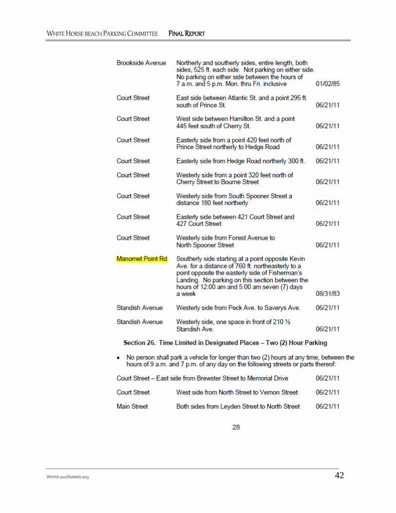
WHITE HORSE BEACH PARKING COMMITTEE FINAL REPORT
WINTER 2012/SUMMER 2013 42

WHITE HORSE BEACH PARKING COMMITTEE FINAL REPORT
WINTER 2012/SUMMER 2013 43

WHITE HORSE BEACH PARKING COMMITTEE FINAL REPORT
WINTER 2012/SUMMER 2013 44

WHITE HORSE BEACH PARKING COMMITTEE FINAL REPORT
WINTER 2012/SUMMER 2013 45

WHITE HORSE BEACH PARKING COMMITTEE FINAL REPORT
WINTER 2012/SUMMER 2013 46

WHITE HORSE BEACH PARKING COMMITTEE FINAL REPORT
WINTER 2012/SUMMER 2013 47

WHITE HORSE BEACH PARKING COMMITTEE FINAL REPORT
WINTER 2012/SUMMER 2013 48

WHITE HORSE BEACH PARKING COMMITTEE FINAL REPORT
WINTER 2012/SUMMER 2013 49

WHITE HORSE BEACH PARKING COMMITTEE FINAL REPORT
WINTER 2012/SUMMER 2013 50

WHITE HORSE BEACH PARKING COMMITTEE FINAL REPORT
WINTER 2012/SUMMER 2013 51

WHITE HORSE BEACH PARKING COMMITTEE FINAL REPORT
WINTER 2012/SUMMER 2013 52

WHITE HORSE BEACH PARKING COMMITTEE FINAL REPORT
WINTER 2012/SUMMER 2013 53

WHITE HORSE BEACH PARKING COMMITTEE FINAL REPORT
WINTER 2012/SUMMER 2013 54

WHITE HORSE BEACH PARKING COMMITTEE FINAL REPORT
WINTER 2012/SUMMER 2013 55
-
Proposed Taylor Avenue Reconstruction Plans Over 2008 Aerial Photo

WHITE HORSE BEACH PARKING COMMITTEE FINAL REPORT
WINTER 2012/SUMMER 2013 56
“No Parking” Areas (highlighted in red) Per Current Traffic Rules & Orders

WHITE HORSE BEACH PARKING COMMITTEE FINAL REPORT
WINTER 2012/SUMMER 2013 57
“No Parking” Areas (highlighted in red) Per Current Traffic Rules & Orders

WHITE HORSE BEACH PARKING COMMITTEE FINAL REPORT
WINTER 2012/SUMMER 2013 58
Potential Parking Spots (Currently prohibited by Plymouth Traffic Rules & Orders)

WHITE HORSE BEACH PARKING COMMITTEE FINAL REPORT
WINTER 2012/SUMMER 2013 59
Potential Parking Spots (Currently prohibited by Plymouth Traffic Rules & Orders)

WHITE HORSE BEACH PARKING COMMITTEE FINAL REPORT
WINTER 2012/SUMMER 2013 60
Potential Parking Spots (Currently prohibited by Plymouth Traffic Rules & Orders)
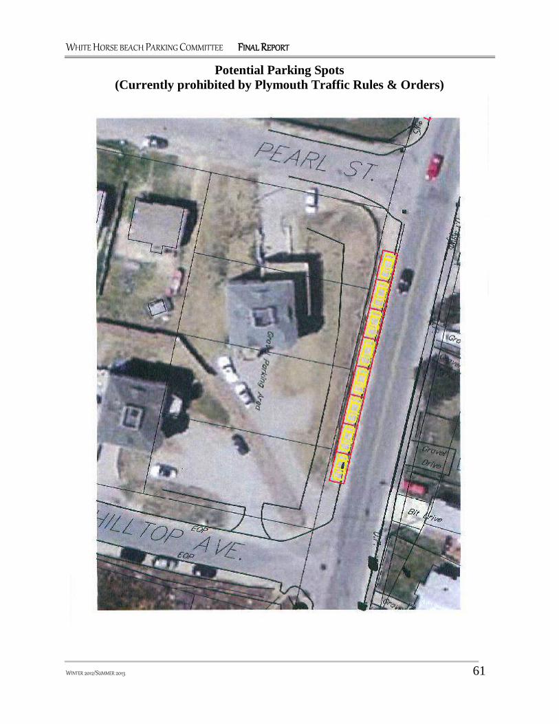
WHITE HORSE BEACH PARKING COMMITTEE FINAL REPORT
WINTER 2012/SUMMER 2013 61
Potential Parking Spots (Currently prohibited by Plymouth Traffic Rules & Orders)

WHITE HORSE BEACH PARKING COMMITTEE FINAL REPORT
WINTER 2012/SUMMER 2013 62

WHITE HORSE BEACH PARKING COMMITTEE FINAL REPORT
WINTER 2012/SUMMER 2013 63

WHITE HORSE BEACH PARKING COMMITTEE FINAL REPORT
WINTER 2012/SUMMER 2013 64
“Satellite Parking”
Manomet Elementary School
Staffing Costs & Projected Revenue
Staff: Qty: Hrly
Rate: # hrs: # wks: Total Salary:
Parking Attendant 1 $ 9.00 56 12 $ 6,048
Supervisor 1 $ 12.44 14 12 $ 2,090
Total Staffing Salary: $ 8,138* *Staffing numbers provided by Recreation Director
Revenue: #
spots: Fee: Days
: #
wks: Daily Revenue Weekly
Revenue Seasonal Revenue
M-F Parking 55 $ 10
5
12 $ 550 $ 2,750 $ 33,000
Weekend Parking 55
$ 15
2
12 $ 825 $ 1,650 $ 19,800
Total Seasonal Revenue $ 52,800
Net Profit to Town: $ 44,662*
*Revenue could go into a ‘revolving fund’ for neighborhood

WHITE HORSE BEACH PARKING COMMITTEE FINAL REPORT
WINTER 2012/SUMMER 2013 65

WHITE HORSE BEACH PARKING COMMITTEE FINAL REPORT
WINTER 2012/SUMMER 2013 66

WHITE HORSE BEACH PARKING COMMITTEE FINAL REPORT
WINTER 2012/SUMMER 2013 67

ATTACHMENT 8

White Horse Beach Public Meeting
Plymouth Public Library
June 23, 2015
RE: Meeting Minutes
Attendance
Present from Town of Plymouth
o David Gould, Director of Marine and Environmental Affairs
o Nathan Cristofori, Natural Resources Warden
Present from Environmental Consulting & Restoration, LLC
o Brad Holmes, Manager, Professional Wetland Scientist
o Cameron Larson, Wetland Scientist
Members of Public Present
Opening Remarks by David Gould
Overview of White Horse Beach Management Plan as of June 23, 2015 by Brad Holmes
Public Discussion
Public vs Private property—important to note that this plan is for public property only
Beach signage
o Trash and litter signs that include fines
o Dog signs (must be leashed, pick up feces, etc.)
o Beach access signs
o Alcohol
o Allowed and disallowed activities
o Signs must be visible and include penalties/fines
o Post for new signs on beach have been installed as of the day of this meeting
Taylor Street/Adjacent streets
o Crosswalks and signs have been ineffective because of location
Re-paint sidewalks in appropriate locations
Visible signs
o Suggestion to consult with the Traffic Steering Committee
o Fence along road and dune should be replaced
o Public vs private parking
o Automobile speeding issues
Natural Resource Protection
o Coastal dune restoration
Sand fencing has been torn down multiple times in the past
Beach grass planting

Sand nourishment
Signs to keep off dunes
Restore dunes along the entire beach
o Restoration of resource areas near Bartlett Brook
o Regular Beach Maintenance
Enforcement—issue that was brought up most frequently
o Need to find ways to enforce current regulations
o Signage
o Regular beach patrol
Plymouth Police
Plymouth Fire
Natural Resource Wardens
Focus patrol on weekends
o Enforcement cameras
Parking/Beach Access
o Refer to 2013 Parking Plan
o Parking permits
Source of revenue
Prevent unauthorized parking
o Limit access to only Plymouth residents
o Entrance fee for beach/beach sticker
Miscellaneous
o Marketing
“Re-market” as a family beach, not a party beach
Limit marketing all together
o Bartlett Brook backs up in winter with sand
o Comments about problems coming from out-of-town beach goers
Moving Forward
Keep meetings organized
Plan is to try to meet one more time this summer
Important for summer residents to be present