weather satellites: planning for the geostationary ... · management division b-275996 march 13,...
TRANSCRIPT
United States General Accounting Office
GAO Report to the Chairman, Subcommitteeon Energy and Environment, Committeeon Science, House of Representatives
March 1997 WEATHERSATELLITES
Planning for theGeostationary SatelliteProgram Needs MoreAttention
GAO/AIMD-97-37


GAO United States
General Accounting Office
Washington, D.C. 20548
Accounting and Information
Management Division
B-275996
March 13, 1997
The Honorable Ken CalvertChairmanSubcommittee on Energy and EnvironmentCommittee on ScienceHouse of Representatives
Dear Mr. Chairman:
This report responds to your predecessor’s request that we review the National Oceanic andAtmospheric Administration’s (NOAA) management of the Geostationary OperationalEnvironmental Satellite (GOES) Program. Specifically, we were asked to assess (1) the agency’sstrategy for procuring satellites in the GOES continuation series, (2) what steps the agencyshould be taking now to prepare for the next generation series of satellites, and (3) whether thepotential exists for improving the system and reducing costs in the long term. The reportrecommends that the NOAA Administrator take certain steps to improve the agency’s planningfor future systems.
We are sending copies of this report to the Ranking Minority Member of your Subcommittee;the Chairmen and Ranking Minority Members of the House Committee on Science; the SenateCommittee on Commerce, Science, and Transportation; the House and Senate Committees onAppropriations; the House Committee on Government Reform and Oversight; and the SenateCommittee on Governmental Affairs. We are also sending copies to the Secretary of Commerceand the Administrator of NOAA. Copies will also be made available to others upon request.
If you have any questions concerning this report, please call me at (202) 512-6240. Other majorcontributors are listed in appendix II.
Sincerely yours,
Jack L. Brock, Jr.Director, Defense Information and Financial Management Systems
Executive Summary
Purpose The National Oceanic and Atmospheric Administration (NOAA) is in theprocess of planning the procurement of new Geostationary OperationalEnvironmental Satellites (GOES) to replace the current series of satellites,which will begin to reach the end of their useful lives in approximately2002. NOAA plans to buy a continuation series of two to four satellites thatwill be very similar to the current series in their capabilities andoperations to fill the potential gap in satellite coverage that could occurbeginning in 2002. Beyond the potential gap in coverage, NOAA has not yetdecided whether to continue procuring the same type of satellites orconsider new designs for a next generation system.
In fiscal year 1998, NOAA plans to spend over $240 million for developmentand operations costs associated with the GOES system. Given that the NOAA
budget is expected to be constrained in the coming years, the Chairman ofthe House Committee on Science, Subcommittee on Energy andEnvironment, requested that GAO assess (1) the agency’s strategy forprocuring continuation series satellites, (2) what steps the agency shouldbe taking now to prepare for the next generation series of satellites, and(3) whether the potential exists for improving the system and reducingcosts in the long term.
Background The GOES system, which has been operational since 1975, plays a criticalrole in weather forecasting. The continuous availability of GOES data is vitalto the success of the National Weather Service’s (NWS) approximately$4.5 billion systems modernization program. GOES satellites are uniquelypositioned to observe the development of hazardous weather, such ashurricanes and severe thunderstorms, and track their movement andintensity so that major losses of property and life can be reduced oravoided. GOES satellites have two primary meteorological instruments: animager and a sounder. The imager collects digital images of portions of theearth’s surface from radiation that is sensed at five different wavelengths.The sounder is mechanically similar but sensitive to a broader range ofspectral wavelengths, which allows it to measure natural variables, such astemperature and humidity, at different levels of the atmosphere. NOAA’soperational strategy calls for two GOES satellites to be active at alltimes—one satellite to observe the Atlantic Ocean and eastern half of theUnited States, and the other to observe the Pacific Ocean and the westernpart of the country. Two GOES satellites are currently in orbit—GOES-8covering the east and GOES-9 in the west. These satellites were launched in1994 and 1995, respectively.
GAO/AIMD-97-37 Weather SatellitesPage 2

Executive Summary
Even though satellites in the GOES series have been operational for over 20years, only one major design change has been implemented. The firstgeneration design, used on GOES-1 through GOES-7, was developedexperimentally by the National Aeronautics and Space Administration(NASA) and subsequently came to be relied upon for the operationalsystem. The second generation, called GOES-Next, represents a completeredesign of the spacecraft and its instruments that allows for thecollection of substantially more and better weather data. The GOES-Nextseries includes the two currently operational satellites, GOES-8 and GOES-9,plus three additional spacecraft that are in different stages of production.Development of this second generation experienced severe technicalproblems, cost overruns, and schedule delays. For example, NOAA’sestimate of the overall development cost for GOES-Next grew from$640 million in 1986 to $2.0 billion in 1996. Also, a nearly 5-year scheduleslip in the launch of the first GOES-Next satellite left NOAA at one point inreal danger of temporarily losing geostationary satellite data coverage,although no gap in coverage ever actually occurred. GAO reported in 1991that design complexity, inadequate management of the program by NOAA
and NASA (NOAA’s agent for the procurement), and poor contractorperformance all contributed to the cost, schedule, and technical problemsexperienced by GOES-Next.1 Although some technical problems remain, thefirst two of these satellites are now producing useful, high quality weatherdata daily.
Results in Brief Based on the best available analysis, the potential for a gap ingeostationary satellite coverage will be significant in the early years of thenext century if procurement of new satellites does not begin soon. Toprevent this problem, NOAA plans to competitively procure two to fourcontinuation series spacecraft that will carry the same meteorologicalinstruments as the current spacecraft and incorporate modest technicalimprovements. The satellites are planned for launch beginning in 2002.Given the importance of maintaining continuous geostationary weathercoverage, NOAA’s plans are reasonable. However, there are inherentdifficulties in determining exactly when and how many of the continuationseries spacecraft will be needed. Despite these difficulties, GAO identifiedseveral specific shortcomings in NOAA’s spacecraft planning process that, ifremedied, could improve planning in the future. They include unclearpolicies for replacing partially failed satellites and backing up launches.
1Weather Satellites: Action Needed to Resolve Status of the U.S. Geostationary Satellite Program(GAO/NSIAD-91-252, July 1991), p. 3.
GAO/AIMD-97-37 Weather SatellitesPage 3

Executive Summary
Also, NOAA has no formal program underway to develop a new spacecraftseries to follow the continuation series. Based on the President’s fiscalyear 1998 budget, NOAA does not plan to begin a follow-on GOES programuntil fiscal year 2003 at the earliest. Given that the opportunity now existsto consider alternatives for a follow-on system, current usage of GOES databy weather forecasters suggests that a reexamination of the GOES satellitearchitecture is warranted. Although requirements have not been formallyupdated since the GOES-Next satellite series was developed, usage of GOES
data has continued to evolve. The current satellite design hosts twometeorological instruments that are devoted to a range of capabilities,some of which are increasing in importance to weather forecasters andothers of which remain largely experimental. Before a decision can bemade about what kind of follow-on satellite system to build, an updatedanalysis of user needs must be completed.
Several new approaches and technologies for geostationary satellitemeteorology have been suggested in recent years by government,academic, and industry experts. Some of these options may offer thepotential for reducing system costs and improving performance in the longterm. Examples include moving to an architecture of smaller satellites aswell as incorporating various spacecraft and instrument technologies thatwere not available for the previous spacecraft generation. However,identifying and evaluating the full range of options will require thoroughengineering analysis. In addition, past NOAA experience shows thatdeveloping new technologies is done most efficiently as a separate line ofeffort, outside of the operational satellite program. Such an effort wouldbenefit from greater collaboration with NASA, whose expertise and supporthave, in the past, significantly contributed to the development of NOAA’sweather satellite systems.
The longer that NOAA continues without actively considering other optionsfor a future system, the more it risks having to procure additionalcontinuation series satellites, because the availability date for a fullydeveloped new satellite system will slip farther into the future. Thepotential advantages of advanced technologies and small satelliteconstellations as well as questions about changing user requirementssuggest that alternatives to the present architecture should be seriouslyconsidered.
GAO/AIMD-97-37 Weather SatellitesPage 4

Executive Summary
Principal Findings
Issues in NOAA’s Planningto Ensure ContinuousGOES Coverage
Based on the best available analysis, the potential for a gap ingeostationary satellite weather coverage will be significant in the earlyyears of the next century if procurement of new satellites does not beginsoon. Although three satellites in the current series are still in productionand scheduled for launch over the next 5 years, designing and producingan entirely new spacecraft would take much longer—approximately 10years, according to aerospace experts. Accordingly, NOAA plans to procurea continuation series of at least two spacecraft that will carry the samemeteorological instruments as the current spacecraft and incorporate onlylimited technical improvements. NOAA expects this approach to allow fordevelopment of the continuation series satellites within 5 years.
Calculating the quantity and need dates for the continuation seriessatellites is a complex process involving factors that cannot be preciselydefined. Although NOAA has determined that it will need the firstcontinuation series satellite in 2002, the actual date that a replacementsatellite is launched may be different. A major risk for any satelliteprogram is the chance that a spacecraft launch will fail, necessitating thatfuture planned launches be moved up to try to compensate for the lostspacecraft. Unexpected component failures on operationalsatellites—such as GOES-8 and GOES-9 have recently experienced—can alsoadvance the need dates for future satellites. Conversely, a string ofsuccessful launches and robust, long-lived satellites can significantly delaythe need for new satellites. Once a change in needs is identified,scheduling a new launch may be constrained by the unavailability offlight-ready replacement spacecraft, launch vehicles and facilities, orfunding to support a launch. Given these risks and uncertainties, NOAA’sprocurement strategy, which calls for two continuation series spacecraftto be built but includes separate options to build two additionalspacecraft, provides a reasonable degree of flexibility to cope withunexpected schedule changes.
We identified several shortcomings in NOAA’s spacecraft planning processthat, if remedied, could lead to better planning in the future. First, the needfor the continuation series arose because planning for a follow-on serieshas been repeatedly deferred since it was first attempted in 1989. Second,NOAA’s official policy for replacing satellites that experience partial failuresis unclear, increasing the uncertainty about when replacements will be
GAO/AIMD-97-37 Weather SatellitesPage 5

Executive Summary
needed. Third, NOAA does not have a consistent policy for providingbackup in the event of a launch failure. Timely initiation of follow-onplanning combined with clearer, more consistent policies for replacingpartially failed spacecraft and backing up launches would provide betterassurance of meeting future needs with minimal risk.
NOAA Is Unprepared toDevelop a Next GenerationGOES System
In addition to procuring satellites to prevent a gap in coverage, NOAA needsto begin planning for a follow-on program of GOES satellites if it is to avoidcontinuing to procure additional continuation series satellites in thefuture. Although several preliminary efforts have been made to study thefeasibility of making incremental enhancements to the currentmeteorological instrument designs, NOAA has no formal program underwayto develop a follow-on series. Based on the President’s fiscal year 1998budget, NOAA does not plan to begin a follow-on GOES program until fiscalyear 2003 at the earliest.
Current usage of GOES data by weather forecasters suggests that areexamination of the GOES satellite architecture is warranted. Althoughrequirements have not been formally updated since the GOES-Next satelliteseries was developed, usage of GOES data has continued to evolve. Thecurrent satellite design hosts two meteorological instruments that aredevoted to a range of capabilities, some of which are increasing inimportance to weather forecasters and others of which remain largelyexperimental. According to NOAA, limited experience with GOES-Next datamakes it difficult to precisely determine which capabilities will be of mostvalue to users in the future. Before a decision can be made about whatkind of follow-on satellite system to build, an updated analysis of userneeds must be completed.
Once user needs are determined and requirements established, a full rangeof potential architectural solutions needs to be identified and evaluated.Several new approaches and technologies for geostationary satellitemeteorology have been suggested in recent years by government,academic, and industry experts. Some of these options may offer thepotential for reducing system costs and improving performance in the longterm. Examples include moving to an architecture of smaller satellites aswell as incorporating various spacecraft and instrument technologies thatwere not available for the previous spacecraft generation. NOAA officialsinvolved in GOES acquisition and development agree that these optionsneed to be considered, given that the follow-on GOES program will besubject to cost constraints.
GAO/AIMD-97-37 Weather SatellitesPage 6

Executive Summary
Identifying and evaluating options will require thorough engineeringanalysis. In addition, past NOAA experience shows that developing newtechnologies is done most efficiently as a separate line of effort, outside ofthe operational satellite program. Such an effort would benefit fromgreater collaboration with NASA, whose expertise and support have, in thepast, significantly contributed to the development of NOAA’s weathersatellite systems.
Matters forCongressionalConsideration
Given that options may exist for NOAA to develop a significantly improvedfollow-on GOES system, the Congress may wish to closely examine thecosts and benefits of different approaches for the timing, funding, andscope of the follow-on program. Further, the Congress may also wish toexamine NASA’s potential role in working with NOAA to support the needs ofgeostationary weather satellites within NASA’s advanced spacecrafttechnology programs.
Recommendations GAO recommends that the NOAA Administrator ensure that the NationalEnvironmental Satellite, Data, and Information Service (NESDIS) clarifiescertain of its GOES planning policies. Further, GAO recommends that theAdministrator prepare a formal analysis of the costs and benefits ofseveral alternatives for the timing, funding, and scope of the follow-onprogram. This analysis should be provided to the Congress for its use inconsidering options for the future of the GOES program. Details of ourrecommendations are included in chapters 2 and 3.
Agency Commentsand Our Evaluation
GAO requested comments on a draft of this report from the Secretary ofCommerce. The Secretary provided written comments, which arediscussed in chapters 2 and 3 and are reprinted in appendix I. TheSecretary concurred with GAO’s recommendation that certain of its GOES
planning policies be clarified. However, the Secretary did not concur withGAO’s recommendations that the NOAA Administrator reconsider theagency’s decision to defer the follow-on program and prepare a formalanalysis of options for such a program. The draft that GAO provided toCommerce was based on its fiscal year 1997 budget, which showed that aGOES follow-on program would begin in 2000. However, the fiscal year 1998budget request, released since then, shows no follow-on programbeginning through 2002. In discussions with GAO, NOAA officials confirmedthat a follow-on program is currently not planned until 2003 at the earliest.
GAO/AIMD-97-37 Weather SatellitesPage 7

Executive Summary
As stated in the report, GAO believes that continued deferral of thefollow-on program is risky because it forgoes the opportunity to identifyand develop a potentially more effective and economical architecture.Furthermore, the longer that NOAA continues without actively consideringother options for a future system, the more it risks having to procureadditional continuation series satellites, because the availability date for afully developed new satellite system will slip farther into the future.
GAO/AIMD-97-37 Weather SatellitesPage 8

GAO/AIMD-97-37 Weather SatellitesPage 9

Contents
Executive Summary 2
Chapter 1 Introduction
12Background 12GOES Satellite Development History 14GOES-Next Development Problems 17Objectives, Scope, and Methodology 18
Chapter 2 Issues in NOAA’sPlanning to EnsureContinuous GOESCoverage
21NOAA’s Strategy for Procuring the Continuation Series 22Difficulties in Determining When and How Many Continuation
Series Satellites Will Be Needed24
Shortcomings in NOAA’s Planning Process 27Conclusions 30Recommendations 30Agency Comments and Our Evaluation 30
Chapter 3 NOAA Is Unpreparedto Develop a NextGeneration GOESSystem
31NOAA Has Studied Only Incremental Enhancements to the
Current Architecture32
Uses of GOES Data Are Evolving 33An Alternative Architecture Could Improve System Flexibility
and Reduce Some Costs36
Advanced Technology Could Improve Performance 37Choosing a Follow-on Design Approach Will Require Thorough
Engineering Analysis39
Collaborating With NASA Could Help NOAA Develop NewSatellite Capabilities
40
Conclusions 43Matters for Congressional Consideration 43Recommendations 43Agency Comments and Our Evaluation 44
Appendixes Appendix I: Comments From the Department of Commerce 46Appendix II: Major Contributors to This Report 55
Related GAO Products 56
Figures Figure 1.1: GOES Satellite Coverage 13
GAO/AIMD-97-37 Weather SatellitesPage 10

Contents
Figure 1.2: GOES 4-7 Satellite Design 15Figure 1.3: GOES-Next Satellite Design 16Figure 2.1: Planned GOES Launch Schedule 25
Abbreviations
ATS Applications Technology SatelliteAVHRR Advanced Very High Resolution RadiometerGAO General Accounting OfficeGATES Geostationary Advanced Technology Environmental
SystemGOES Geostationary Operational Environmental SatelliteGPS Global Positioning SystemGPS/MET Global Positioning System/MeteorologyMIT Massachusetts Institute of TechnologyNASA National Aeronautics and Space AdministrationNESDIS National Environmental Satellite, Data, and Information
ServiceNOAA National Oceanic and Atmospheric AdministrationNWS National Weather ServiceOSIP Operational Satellite Improvement ProgramTIROS Television and Infrared Observational Satellite
GAO/AIMD-97-37 Weather SatellitesPage 11
Chapter 1
Introduction
Background The GOES satellite system, which has been operational since 1975, plays acritical role in weather forecasting. The continuous availability of GOES
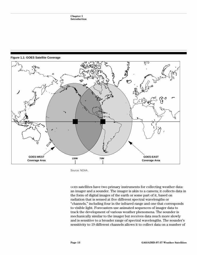
data is vital to the success of NWS’ approximately $4.5 billion systemsmodernization program. GOES is one of two weather satellite systemsoperated by NOAA; the other is a system of polar-orbiting satellites.1 Unlikethe polar satellites, geostationary weather satellites are placed into aspecial orbit that allows them to continuously maintain the same view ofthe earth’s surface.2 Thus, they are uniquely positioned to observe thedevelopment of hazardous weather, such as hurricanes and severethunderstorms, and track their movement and intensity so that majorlosses of property and life can be reduced or avoided. Further, the uniqueability of geostationary satellites to provide broad, continuously updatedcoverage of atmospheric conditions over land as well as oceans is veryimportant to NOAA’s weather forecasting operations.3
NOAA’s operating strategy calls for two GOES satellites to be active at alltimes—one satellite to observe the Atlantic Ocean and the eastern half ofthe U.S., and the other to observe the Pacific Ocean and the western partof the country. Figure 1.1 shows the coverage provided by two GOES
satellites.
1Polar satellites are launched on a roughly north-south trajectory that takes them over the polarregions of the earth. As the earth turns beneath them, polar satellites observe a different portion of theearth’s surface during each orbit. Thus they can provide observations of the weather over any givenlocation, such as the United States, only infrequently.
2Geostationary orbits are located approximately 22,300 miles out in space. In contrast, polar satellitesorbit at an altitude of about 500 miles.
3GOES satellites carry out other secondary missions as well, such as monitoring conditions in thespace environment around the earth, relaying data from remote surface-based instruments to NOAA’scommand and data acquisition stations, and relaying distress signals from aircraft or marine vessels tosearch and rescue ground stations.
GAO/AIMD-97-37 Weather SatellitesPage 12
Chapter 1
Introduction
Figure 1.1: GOES Satellite Coverage
GOES-EAST Coverage Area
GOES-WEST Coverage Area
135°W 75°W
Source: NOAA.
GOES satellites have two primary instruments for collecting weather data:an imager and a sounder. The imager is akin to a camera; it collects data inthe form of digital images of the earth or some part of it, based onradiation that is sensed at five different spectral wavelengths or“channels,” including four in the infrared range and one that correspondsto visible light. Forecasters use animated sequences of imager data totrack the development of various weather phenomena. The sounder ismechanically similar to the imager but receives data much more slowlyand is sensitive to a broader range of spectral wavelengths. The sounder’ssensitivity to 19 different channels allows it to collect data on a number of
GAO/AIMD-97-37 Weather SatellitesPage 13

Chapter 1
Introduction
natural variables, such as temperature and humidity, and attribute thosemeasurements to specific levels of the earth’s atmosphere. The data fromboth the imager and sounder are relayed to a ground station at WallopsIsland, Virginia, which processes the data to make them usable by weatherforecasters. Then the data are retransmitted back up to the GOES satellites,which broadcast them to the weather forecasting community.
NOAA has never been directly responsible for the design and developmentof any of its meteorological satellites. Instead, the agency has relied onNASA’s expertise in spacecraft design and development. After NOAA definesuser requirements for its satellite systems, it turns them over to NASA tocontract with industry to design and develop satellites that meet NOAA’sneeds. NASA launches and tests the satellites, which are subsequentlyturned over to NOAA to operate. Beginning in the 1970s, NASA had a formalongoing program, called the Operational Satellite Improvement Program(OSIP), to develop and demonstrate experimental versions of advancedmeteorological satellites and instruments. Successful designs from the OSIP
program were often incorporated into NOAA’s operational satellite systems.OSIP was terminated in 1981 due to budgetary constraints at NASA.However, NASA continues to act as the procurement agent for NOAA’sweather satellites.
GOES SatelliteDevelopment History
Even though GOES satellites have been operational for over 20 years, onlyone major design change has been implemented. The first generationdesign was developed and operated experimentally by NASA in the 1960sand early 1970s and subsequently became the basis for the firstoperational satellites, GOES-1 through GOES-7. Figure 1.2 is an illustration ofthe first generation design. This series of satellites was “spin-stabilized,”meaning that the satellites slowly spun while in orbit to maintain a stableposition with respect to the earth. While these satellites operatedeffectively, they had technical limitations that NOAA wished to eventuallyovercome. The imager and the sounder on these satellites4 shared thesame telescopic viewing apparatus and could not collect data at the sametime. Further, because the satellite was spinning, it had to collect data veryslowly, capturing one narrow band of data each time that its field-of-viewswung past the earth.5 A complete set of sounding data, for example, took2 to 3 hours to collect.
4A sounder was first added to the existing satellite design as an experiment on GOES-4. Sounders haveflown on all subsequent GOES satellites.
5At a geostationary orbit, the earth would fill only 23 degrees (6 percent) of the satellite’s 360 degreerotational view.
GAO/AIMD-97-37 Weather SatellitesPage 14

Chapter 1
Introduction
Figure 1.2: GOES 4-7 Satellite Design
Source: NASA.
Legend:
EPS - Electrical Power SystemHEPAD - High Energy Proton and Alpha DetectorUHF - Ultra High FrequencyVAS - Visible and Infrared Spin Scan Radiometer (VISSR) Atmospheric Sounder
In 1982, the National Weather Service (NWS) within NOAA sponsored areview of what new technologies were available and what additionalmissions could be performed by a new generation of geostationarysatellites. The review was supported by NOAA’s National EnvironmentalSatellite, Data and Information Service (NESDIS) as well as by NASA’sGoddard Space Flight Center and industry representatives. Based on inputfrom these sources, requirements for a new generation spacecraft weredeveloped.
GAO/AIMD-97-37 Weather SatellitesPage 15
Chapter 1
Introduction
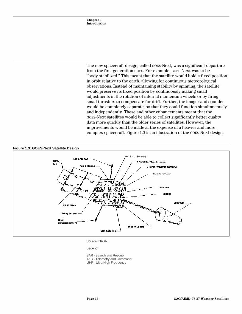
The new spacecraft design, called GOES-Next, was a significant departurefrom the first generation GOES. For example, GOES-Next was to be“body-stabilized.” This meant that the satellite would hold a fixed positionin orbit relative to the earth, allowing for continuous meteorologicalobservations. Instead of maintaining stability by spinning, the satellitewould preserve its fixed position by continuously making smalladjustments in the rotation of internal momentum wheels or by firingsmall thrusters to compensate for drift. Further, the imager and sounderwould be completely separate, so that they could function simultaneouslyand independently. These and other enhancements meant that theGOES-Next satellites would be able to collect significantly better qualitydata more quickly than the older series of satellites. However, theimprovements would be made at the expense of a heavier and morecomplex spacecraft. Figure 1.3 is an illustration of the GOES-Next design.
Figure 1.3: GOES-Next Satellite Design
Source: NASA.
Legend:
SAR - Search and RescueT&C - Telemetry and CommandUHF - Ultra High Frequency
GAO/AIMD-97-37 Weather SatellitesPage 16

Chapter 1
Introduction
GOES-NextDevelopmentProblems
Although GOES-Next represented a complete redesign of NOAA’sgeostationary satellite system, satellite industry observers told us that thetechnical risks involved in developing GOES-Next appeared in the early1980s to be manageable. Polar-orbiting meteorological spacecraft hadalready evolved from spin-stabilized to body-stabilized designs, and theGOES-Next builder, Ford Aerospace,6 had already built a body-stabilizedgeostationary meteorological satellite for India. Furthermore, theinstrument manufacturer, ITT Corporation, had proposed designs thatwere closely based on successful imagers and sounders it was building forNOAA’s polar-orbiting satellites. On this basis, NOAA did not authorize andNASA did not require engineering analysis prior to GOES-Next developmentwork.
Despite the spacecraft and instrument design heritage, the GOES-Nextprogram experienced severe technical problems, massive cost overruns,and dangerous schedule delays. Technical issues that had seemedstraightforward when the spacecraft design was being conceptualizedproved to be substantially more difficult to implement. For example, theoriginal design did not sufficiently take into consideration the harshness ofgeostationary orbit, which is subject to large daily temperature variationsthat can stress and warp ordinary materials. Accordingly, the scan mirrorson the instruments had to be completely redesigned using other materials.It was also discovered that it would be very difficult to establish the finepointing necessary to meet requirements for accurately mapping thesatellite’s detailed images to their exact position on earth.7
These and other problems led to an increase of over 200 percent in NOAA’sestimate of the overall development cost of the GOES-next program—from$640 million in 1986 to $2.0 billion in 1996. Also, the first launch of aGOES-next satellite, which had been planned for July 1989, did not occuruntil April 1994. This nearly 5-year schedule slip left NOAA in real danger oftemporarily losing geostationary satellite data coverage. Fortunately, dueto the exceptional robustness of the last remaining first-generationsatellite, GOES-7, as well as the use of a borrowed European satellite, NOAA
was able to avoid a gap in coverage. GAO reported in 1991 that designcomplexity, inadequate management of the program by NASA and NOAA, andpoor contractor performance all contributed to the cost, schedule, and
6Now called Space Systems/Loral.
7The process of establishing the satellite’s exact position and maintaining it through a series of imagescontinues to pose problems for NOAA even as the GOES-Next satellites have become operational.
GAO/AIMD-97-37 Weather SatellitesPage 17

Chapter 1
Introduction
technical problems experienced by the GOES-next program.8 Althoughsome technical problems remain, the first two of these satellites, GOES-8and GOES-9, are now producing useful, high quality weather data daily.
The GOES-Next contract with Space Systems/Loral is for five spacecraft,designated GOES-I through GOES-M.9 Once the first two in the series, GOES-Iand GOES-J, were successfully launched and placed in orbit, they wereredesignated GOES-8 and GOES-9 respectively. The other three spacecraft inthe GOES-Next series, GOES-K, GOES-L, and GOES-M, are in various stages ofproduction. The GOES-K spacecraft has been completed and is scheduledfor launch in April 1997. If GOES-8 and GOES-9 are still operational then,GOES-K will be stored at a central location in orbit and activated wheneither of its two predecessors fails. GOES-M and GOES-L are planned to belaunched in 2000 and 2002, respectively. GOES-M, which has a strongerframe than the other satellites in the series, will be launched ahead ofGOES-L in order to accommodate a new and heavier secondary instrumentfor measuring the space environment, called the Solar X-ray Imager.
Objectives, Scope,and Methodology
In February 1996, the House Committee on Science, Subcommittee onEnergy and Environment, requested that we review NOAA’s management ofthe GOES Program. On the basis of subsequent discussions withsubcommittee staff, our specific objectives were to assess: (1) the agency’sstrategy for procuring continuation series satellites, (2) what steps theagency should be taking now to prepare for the next generation series ofsatellites, and (3) whether the potential exists for improving the systemand reducing costs in the long term.
To meet our objectives, we reviewed NOAA and NASA documents regardingGOES historical background, current status, mission operations, spacecraftand instrument improvements, ground systems, future procurementstrategies, and proposed technology infusion. We reviewed NASA
documents regarding the GOES Project and proposed technology infusion.We reviewed NOAA cost and budget documents and NASA ProgramOperating Plans. In addition to discussing these issues with agencyofficials from NOAA and NASA, we met with a broad range of representativesfrom academia and industry. Staff also attended a 3-day conference on
8Weather Satellites: Action Needed to Resolve Status of the U.S. Geostationary Satellite Program(GAO/NSIAD-91-252), July 24, 1991, p. 3.
9Weather satellites are given an alphabetic designation until they are launched; they are then assigneda number in the series.
GAO/AIMD-97-37 Weather SatellitesPage 18

Chapter 1
Introduction
“GOES-8 and Beyond,” sponsored by the International Society for OpticalEngineering.
Specifically, with regard to the continuation series procurement strategy,we obtained and analyzed information from NOAA and NASA satelliteacquisition officials. We discussed our analysis and obtained additionalinformation from industry representatives of:
• Hughes Space and Communications Company, El Segundo, California;• Lockheed Martin Corporation, Sunnyvale, California; and• Space Systems/Loral, Palo Alto, California.
Regarding what steps the agency should be taking now to prepare for thenext generation series of satellites, we obtained information fromresearchers and other officials at a range of NOAA and NASA facilities,including:
• NOAA System Acquisition Office, Silver Spring, Maryland;• NOAA NESDIS GOES Program Office, Suitland, Maryland;• NOAA NESDIS Cooperative Institute for Meteorological Satellite Studies,
Madison, Wisconsin;• NOAA NESDIS Cooperative Institute for Research in the Atmosphere, Ft.
Collins, Colorado;• NOAA NWS Headquarters, Silver Spring, Maryland;• NOAA NWS Weather Forecast Offices in Sullivan, Wisconsin; Denver,
Colorado; and Pueblo, Colorado;• NOAA Forecast Systems Laboratory, Boulder, Colorado;• NWS Cooperative Program for Operational Meteorology, Education, and
Training, Boulder, Colorado; and• NASA GOES Project Office, Goddard Space Flight Center, Greenbelt,
Maryland.
Regarding the potential for improving the GOES system while reducingcosts in the long run, we began by obtaining information from NOAA andNASA officials at the sites listed above. We analyzed this information andsought additional input from representatives of industry and academia,including:
• Aerospace Corporation, El Segundo, California;• Applied Physics Laboratory, Johns Hopkins University, Laurel, Maryland;• Ball Aerospace & Technologies Corporation, Boulder, Colorado;• Hughes Space and Communications Company, El Segundo, California;
GAO/AIMD-97-37 Weather SatellitesPage 19

Chapter 1
Introduction
• Lockheed Martin Corporation, Sunnyvale, California;• MITRE Corporation, McLean, Virginia;• National Research Council, Washington, D.C.;• Northrop Grumman Corporation, Baltimore, Maryland;• Space Systems/Loral, Palo Alto, California;• TRW Space and Electronics Group, Redondo Beach, California; and• University Corporation for Atmospheric Research, Boulder, Colorado.
We were unable to perform a detailed audit of the cost of the continuationseries and next generation satellites because cost information wasunavailable. A budget figure of $2.2 billion for a program to build fourspacecraft had been estimated within NOAA for the fiscal year 1997 budget.However, during our audit, NOAA restructured the program and itsprocurement strategy on two different occasions, each of which resultedin different cost estimates. At the time we concluded our review, NOAA’sSystem Acquisition Office, which will manage the continuation seriesprocurement, did not have an official estimate for the overall cost of theprogram.
We conducted our review from March 1996 through February 1997, inaccordance with generally accepted government auditing standards. Werequested written comments on a draft of this report from the Secretary ofCommerce. The Secretary provided us with written comments that arediscussed in chapters 2 and 3 and are reprinted in appendix I.
GAO/AIMD-97-37 Weather SatellitesPage 20

Chapter 2
Issues in NOAA’s Planning to EnsureContinuous GOES Coverage
Based on the best available analysis, the potential for a gap ingeostationary satellite weather coverage will be significant in the earlyyears of the next century if procurement of new satellites does not beginsoon. Although three satellites in the current series are still in productionand scheduled for launch over the next 5 years, designing and producingan entirely new spacecraft would take much longer—approximately 10years, according to aerospace experts. Accordingly, NOAA plans to procureat least two “continuation series”1 spacecraft that will carry the samemeteorological instruments as the current spacecraft and incorporate onlylimited technical improvements. NOAA expects this approach to allow fordevelopment of the new spacecraft within 5 years.
Calculating the quantity and need dates for the continuation series is acomplex process involving factors that cannot be precisely defined.Although NOAA has determined that it will need the first continuation seriessatellite in 2002, the actual date that a replacement satellite is launchedmay be different. According to NOAA officials, a major risk for any satelliteprogram is the chance that a spacecraft launch will fail, necessitating thatfuture planned launches be moved up to try to compensate for the lostspacecraft. Unexpected component failures on operationalsatellites—such as GOES-8 and GOES-9 have recently experienced—can alsoadvance the need dates for future satellites. Conversely, a string ofsuccessful launches and robust, long-lived satellites can significantly delaythe need for new satellites. Once a change in needs is identified,scheduling a new launch may be constrained by the unavailability offlight-ready replacement spacecraft, launch vehicles and facilities, orfunding to support a launch. Given these risks and uncertainties, NOAA’sprocurement strategy, which calls for two continuation series spacecraftto be built but includes separate options to build two additionalspacecraft, provides a reasonable degree of flexibility to cope withunexpected schedule changes.
We identified several shortcomings in NOAA’s spacecraft planning processthat, if remedied, could lead to better planning in the future. First, the needfor the continuation series arose because planning for a follow-on serieshas been repeatedly deferred since it was first attempted in 1989. Second,NOAA’s official policy for replacing satellites that experience partial failuresis unclear, increasing the uncertainty about when replacements will be
1NOAA does not have an official name for this series of satellites. During our audit, NOAA officialsoriginally referred to the series as “clones.” Later, after revising their procurement strategy, theyreferred to them as “gap fillers.” In comments on a draft of the report, the Department of Commerceobjected to the use of the term “gap fillers.” Accordingly, we have adopted the phrase “continuationseries” for our final report.
GAO/AIMD-97-37 Weather SatellitesPage 21

Chapter 2
Issues in NOAA’s Planning to Ensure
Continuous GOES Coverage
needed. Third, NOAA does not have a consistent policy for providingbackup in the event of a launch failure. More consistent policies forreplacing partially failed spacecraft and backing up launches wouldprovide better assurance of meeting future needs with minimal risk.
NOAA’s Strategy forProcuring theContinuation Series
In order to procure continuation series spacecraft quickly, NOAA plans tominimize design changes from the current series. The same meteorologicalinstruments as the current series will be used, and the spacecraft itself(called the spacecraft “bus”) will be very similar. According to governmentand industry officials, limiting the amount of new design work shouldmake an accelerated procurement feasible. NOAA, working through NASA, itsprocurement agent, has already negotiated a contract with the instrumentmanufacturer, ITT Corporation, to deliver up to four additional sets ofGOES imagers and sounders to be flown on the continuation seriessatellites. NOAA and NASA also plan to soon issue a Request for Proposalsfor two to four spacecraft busses and expect several manufacturers tosubmit bids. In most cases, bids are likely to be based on modifiedversions of standard spacecraft busses that manufacturers have developedto satisfy commercial needs for geostationary communications satellites.NOAA and NASA plan to negotiate a firm fixed-price contract with the winnerof the spacecraft bus competition.
Although the instruments on the continuation series spacecraft will beidentical to those currently in use, the spacecraft busses will not. Thecurrent spacecraft bus, which was designed by Space Systems/Loral in themid 1980s, has never been able to fully meet NOAA’s original GOES-Nextspecifications for spacecraft pointing. Designing the spacecraft to pointvery precisely at the earth and maintain that precise orientation isimportant because it allows the data collected by the instruments,especially the imager, to be mapped very accurately to their exact locationon the surface of the earth. Because the GOES-Next spacecraft has beenunable to achieve the originally required precision, extra work routinelyneeds to be done by spacecraft operators to correct for errors in mappingGOES data to its proper position over the earth’s surface. According to NASA
and NOAA officials, improvements in pointing accuracy made incommercial spacecraft busses since the time that the GOES-Next designwas finalized will better meet original GOES-Next specifications and areexpected to be incorporated into the continuation series spacecraft.
Other, relatively minor improvements are expected in the spacecraftbusses as well. For example, an improved power system, based on more
GAO/AIMD-97-37 Weather SatellitesPage 22

Chapter 2
Issues in NOAA’s Planning to Ensure
Continuous GOES Coverage
recent battery technology, should reduce certain brief observation gapsthat occur periodically with the current design.
NOAA considered several other approaches before arriving at its currentprocurement strategy. Originally, NOAA intended to procure four or fiveadditional “clones” of the current spacecraft from Loral on a sole-sourcebasis. The clones would have been largely identical to the currentspacecraft, using new parts only in cases where original parts were nolonger available. However NASA and NOAA officials jointly concluded thatthe government would not be justified in avoiding a competitiveprocurement, and this strategy was dropped. NOAA then considered buyingjust one or two clones from Loral, to be followed by a competitiveprocurement for a continuation series. In September 1996, we reportedthat significant cost savings were not expected from the sole-source cloneprocurement and that requirements for a follow-on system had not beendetermined.2 Because of concerns raised by ourselves and others, NOAA
eventually also abandoned this second strategy.
NOAA’s current strategy has advantages over earlier approaches thatinvolved buying clones of the GOES-Next spacecraft. As discussed above,procuring a new spacecraft bus will allow NOAA to take advantage oftechnical improvements that have already been developed for commercialcustomers, such as greater pointing accuracy and a more capable powersubsystem. In addition, use of a competitively awarded, firm fixed-pricecontract can be expected to help control or reduce costs.
While moving to a fully competitive procurement approach for thecontinuation series, NOAA is also planning to reserve the option to obtainan additional satellite in the current series in the event that one is neededbefore the first satellite in the continuation series can be completed. To dothis, NOAA and NASA are negotiating a “warranty option” as an extension tothe current contract with Space Systems/Loral. Under this arrangement,NASA will contract with Loral to procure necessary long-lead time parts sothat it is ready to build an extra spacecraft of the current type, if such aspacecraft is needed due to (1) the premature failure of either GOES-8 orGOES-9, which were designed to last 5 years each, or (2) a launch failure ofthe GOES-K spacecraft in April 1997. Should either of these occur, NOAA
plans to advance the launches of GOES-L and GOES-M and subsequentlylaunch the warranty spacecraft to ensure continuity until the firstcontinuation series spacecraft is available. NOAA and NASA will determine
2NOAA Satellites (GAO/AIMD-96-141R, September 13, 1996).
GAO/AIMD-97-37 Weather SatellitesPage 23
Chapter 2
Issues in NOAA’s Planning to Ensure
Continuous GOES Coverage
by mid-1998 whether to exercise this warranty option and completeconstruction of the additional spacecraft.
NOAA does not yet know what the continuation series will cost. A budgetfigure of $2.2 billion for a program to build four spacecraft had beenestimated within NOAA for the fiscal year 1997 budget. However, asdiscussed above, NOAA restructured the program and its procurementstrategy on two different occasions, each of which resulted in differentcost estimates. At the time we concluded our review, NOAA’s SystemAcquisition Office, which will manage the continuation seriesprocurement, did not have an official estimate for the overall cost of theprogram.
Difficulties inDetermining Whenand How ManyContinuation SeriesSatellites Will BeNeeded
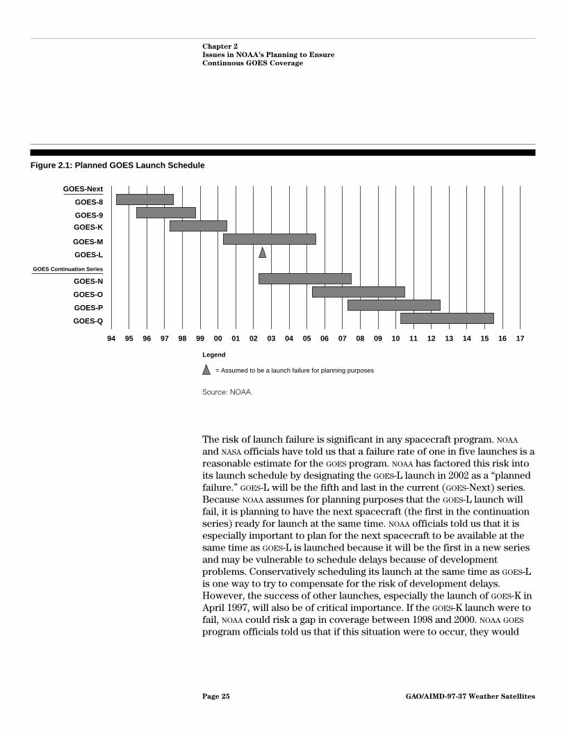
Calculating the quantity and need dates for the continuation seriessatellites is a complex process involving factors that cannot be preciselydefined. Although NOAA has determined that it will need the first one in2002, the actual date that a replacement satellite is launched may bedifferent. Figure 2.1 shows NOAA’s planned GOES launch schedule. A majorrisk for any satellite program is the chance that a spacecraft launch willfail, necessitating that future planned launches be moved up to try tocompensate for the lost spacecraft. Unexpected component failures onoperational satellites—such as GOES-8 and GOES-9 have recentlyexperienced—can also advance the need dates for future satellites.Conversely, a string of successful launches and robust, long-lived satellitescan significantly delay the need for new satellites. Once a change in needsis identified, scheduling a new launch may be constrained by theunavailability of flight-ready replacement spacecraft, launch vehicles andfacilities, or funding to support a launch. Given these risks anduncertainties, NOAA’s procurement strategy, which calls for two spacecraftto be built but includes separate options to build two additionalspacecraft, provides a reasonable degree of flexibility to cope withunexpected schedule changes.
GAO/AIMD-97-37 Weather SatellitesPage 24
Chapter 2
Issues in NOAA’s Planning to Ensure
Continuous GOES Coverage
Figure 2.1: Planned GOES Launch Schedule
94 95 96 97 98 99 00 01 02 03 04 05 06 07 08 09 10 11 12 13 14 15 16 17
GOES-L
GOES-Next
GOES-8
GOES-9
GOES-K
GOES Continuation Series
GOES-O
GOES-N
GOES-M
GOES-Q
GOES-P
Legend
= Assumed to be a launch failure for planning purposes
Source: NOAA.
The risk of launch failure is significant in any spacecraft program. NOAA
and NASA officials have told us that a failure rate of one in five launches is areasonable estimate for the GOES program. NOAA has factored this risk intoits launch schedule by designating the GOES-L launch in 2002 as a “plannedfailure.” GOES-L will be the fifth and last in the current (GOES-Next) series.Because NOAA assumes for planning purposes that the GOES-L launch willfail, it is planning to have the next spacecraft (the first in the continuationseries) ready for launch at the same time. NOAA officials told us that it isespecially important to plan for the next spacecraft to be available at thesame time as GOES-L is launched because it will be the first in a new seriesand may be vulnerable to schedule delays because of developmentproblems. Conservatively scheduling its launch at the same time as GOES-Lis one way to try to compensate for the risk of development delays.However, the success of other launches, especially the launch of GOES-K inApril 1997, will also be of critical importance. If the GOES-K launch were tofail, NOAA could risk a gap in coverage between 1998 and 2000. NOAA GOES
program officials told us that if this situation were to occur, they would
GAO/AIMD-97-37 Weather SatellitesPage 25

Chapter 2
Issues in NOAA’s Planning to Ensure
Continuous GOES Coverage
attempt to move up the GOES-L or GOES-M launches to reduce the length ofthe coverage gap.
Unexpected component failures are another source of risk to the launchschedule. GOES-8 and GOES-9, for example, are now expected to operate foronly 3 years, due to several technical problems that were unforeseen whenthey were launched. The two satellites were launched in April 1994 andMay 1995, respectively, and had been designed to last 5 years each. Themost serious of the technical problems is a tendency of the motorwindings within the satellites’ meteorological instruments to break due tothermal stress.3 Each of the satellite’s two instruments has a primary and abackup motor winding. If both windings fail, the instrument cannotoperate. The 3-year lifetime for GOES-8 and GOES-9 was determined in mid1996 after one winding (out of a total of four) had already failed on eachspacecraft. If the revised predictions for the lifetimes of GOES-8 and GOES-9are accurate, NOAA runs the risk of having only one operational satellite(GOES-K, assuming it is successfully launched in April 1997) between 1998and 2000. As described above for launch failures, if this situation were tooccur, NOAA officials would attempt to move up the GOES-L or GOES-Mlaunches to reduce the length of the coverage gap. They would also likelyexercise the warranty option on the GOES-Next contract to ensurecontinuity until the first continuation series satellite were available.
Although it is possible to move up scheduled launches, NOAA officials saythat it is difficult to do so for several reasons. First, the spacecraft itselfmust be ready for launch at the earlier date, which may not be practical ifintegration and ground testing have not been completed well in advance ofthe previously anticipated launch date. Second, only a limited number ofcommercial launch opportunities (usually six) are available each year forthe Atlas launch vehicle that GOES spacecraft are designed to use.4 Most, ifnot all, of those launch opportunities are reserved far in advance. In orderto move a launch forward, NOAA officials need to be able to find anotherscheduled launch that can be deferred and replaced by the GOES
spacecraft. Third, it may be difficult to move a launch forward from onefiscal year to another because funding may not be available to support alaunch. NOAA officials told us that a GOES launch costs approximately
3Other technical problems have arisen as well. Some of GOES-8’s electronic components have beendamaged by electrostatic discharge, prompting the installation of additional shielding on the rest of theGOES-Next spacecraft. GOES-8 also experienced a failure within its attitude stabilization system,which is being compensated for through redundant components.
4NOAA’s policy is to use commercial launch services wherever possible.
GAO/AIMD-97-37 Weather SatellitesPage 26

Chapter 2
Issues in NOAA’s Planning to Ensure
Continuous GOES Coverage
$25 million (not including the cost of the Atlas IIA launch vehicle itself,which is approximately $80 to 90 million).
Because of the many uncertainties in its planned launch schedule, NOAA
has not made a final determination of how many satellites in thecontinuation series it will procure. The possibility of exercising thewarranty option on the current GOES-Next contract, in addition to thechance that the existing satellites will last longer than 3 years and thatnone of the planned launches will fail, are all factors that could delay theneed date for the first continuation series spacecraft, either singly or incombination. Conversely, NOAA’s current predictions for satellite lifetimesand launch failures could hold true, in which case the first continuationseries spacecraft would be needed in 2002.
The number of continuation series satellites needed also depends on whenthe potential for a coverage gap ends. The potential gap will end wheneverthe first of a new, follow-on series of satellites is available for deployment.As stated earlier, government and industry aerospace experts agree that ittakes approximately 10 years to develop a new spacecraft system. If workwere begun in 1998, the first spacecraft in a new GOES series would,therefore, be ready in about 2008 and could be launched as the GOES-Qspacecraft. (See figure 2.1.) Under this scenario, three continuation seriessatellites would be needed (GOES-N, -O, and -P). If satellites in the currentseries last longer than NOAA expects, or the expected launch failure doesnot occur, NOAA’s schedule could easily slip one or two years for the laterlaunches. In that situation, only two continuation series satellites might beneeded.
NOAA’s planned continuation series contract will be for two spacecraft withtwo separate options for one additional spacecraft each. Thus, as few astwo or as many as four spacecraft may be procured through this contract.Given the uncertainties in the launch schedule, NOAA’s flexibleprocurement strategy is reasonable.
Shortcomings inNOAA’s PlanningProcess
We identified several shortcomings in NOAA’s spacecraft planning processthat, if remedied, could lead to better planning in the future. First, the needfor the continuation series exists now only because planning for afollow-on series has been repeatedly deferred since it was first attemptedin 1989. Second, NOAA’s official policy for replacing satellites thatexperience partial failures is unclear, increasing the uncertainty aboutwhen replacements will be needed. Third, NOAA does not have a consistent
GAO/AIMD-97-37 Weather SatellitesPage 27

Chapter 2
Issues in NOAA’s Planning to Ensure
Continuous GOES Coverage
policy for providing backup in the event of a launch failure. Timelyinitiation of follow-on planning combined with clearer, more consistentpolicies for replacing partially failed spacecraft and backing up launcheswould provide better assurance of meeting future needs with minimal risk.
Follow-on Planning HasBeen Deferred
NOAA officials have recognized for many years that a follow-on program toGOES-Next would have to be started early in order to avoid facing apotential gap in coverage. In 1989, NOAA commissioned a working group toidentify requirements for a follow-on system. A list of requirements wasdeveloped and turned over to NASA in May 1989 for an assessment ofarchitectural options for a follow-on GOES program. Specifically, NOAA
asked that NASA examine options for modifying the GOES-Next system toimprove efficiency, reduce costs, and satisfy the new requirements. Inresponse, NASA examined a range of three architectural options andpresented its results in October 1990. NASA’s final report indicated that thestudy had been very limited, both by resources5 and by the restriction ofonly looking at modifications to the GOES-Next architecture. NASA
recommended that a more thorough study be conducted and thatdevelopment work be immediately begun on the more challengingtechnical features of its design options. However, no further resourceswere committed to this line of effort.
Since 1990, NOAA officials involved in the GOES program have made severalattempts to initiate a follow-on program but have not received agencyapproval to move forward. An internal presentation delivered inMarch 1993 proposed studying a number of alternative approaches to thecurrent GOES architecture, including flying low-cost weather cameras assecondary payloads on non-NOAA geostationary satellites. The presentationstressed the need to begin a formal study phase in fiscal year 1996 in orderto have sufficient time to develop and implement a new architecture by2008. Another presentation made in April 1995 also urged that engineeringstudies be conducted early in order to meet tight time frames. Both the1993 and 1995 presentations assumed that several additional spacecraft inthe GOES-Next series would be procured before the first follow-on satellitewould be ready in 2008. Program officials told us that, faced with budgetconstraints, NOAA did not act on any of the recommendations of thesestudies.
5NOAA and NASA estimates for the cost of a thorough study ranged from $3 to $6 million; however,NASA received only $1.56 million to conduct the study.
GAO/AIMD-97-37 Weather SatellitesPage 28

Chapter 2
Issues in NOAA’s Planning to Ensure
Continuous GOES Coverage
Satellite ReplacementPolicy Is Unclear
NOAA’s official policy for replacing partially failed satellites is unclear. Thestated policy has been to launch and activate a replacement satellite ifeither of the two primary meteorological instruments (the imager or thesounder) fails on either of the two operational spacecraft. However,according to NASA and NOAA officials, it is not certain that a replacementwould actually be launched in the event of a sounder failure, since sounderdata is less critical than imager data. (Use of sounder data is discussed atgreater length in chapter 3.) Also, no official criteria exist for launching areplacement satellite if other partial failures were to occur. For instance, adetector failure in a satellite’s imager could reduce the number of channelsthat it uses to collect data. Such a reduction may or may not be cause toreplace the satellite. NOAA officials told us that they prefer to exercisejudgement on a case-by-case basis as specific failures occur. However, thelack of explicit criteria for replacement makes it more difficult to forecasthow soon new satellites are most likely to be needed.
Launch Backup Policy IsArbitrary
As discussed above, all spacecraft programs have to address the risk oflaunch failure. However, NOAA’s approach of designating certain launchesas “planned failures” and providing backup spacecraft for only thoselaunches is arbitrary, because NOAA does not know in advance whichlaunches will actually fail. In other words, the risk of a launch failure is nogreater for the “planned failure” than for any of the other launches, whichdo not have specifically designated backups. Although NOAA’s approach iseffective in putting an extra spacecraft into the production stream tocompensate for a launch failure, it is ineffective in providing backup foreach launch. An alternative approach would be to schedule each launch tobe backed up by the next spacecraft in the production stream. Such anapproach would not require procurement of any additional spacecraft orlaunch vehicles and would enhance NOAA’s ability to compensate forlaunch failures by planning to have spacecraft always available for backuplaunches.
According to NOAA satellite acquisition officials, the GOES programoriginally included the concept of maintaining an on-orbit spare inaddition to the two operational satellites. The spare would be maintainedin a central position and then moved either east or west to replace the firstoperational satellite that failed. As soon as possible after the on-orbit sparewas activated, a new spare would be launched. If both GOES-8 and GOES-9are still operating in April 1997 when GOES-K is launched, it will be put intoon-orbit storage in the central location for up to 2 years. However, asidefrom this particular case, NOAA has not decided to move to this method of
GAO/AIMD-97-37 Weather SatellitesPage 29

Chapter 2
Issues in NOAA’s Planning to Ensure
Continuous GOES Coverage
backup. Among aerospace experts, on-orbit storage of satellites iscontroversial. Although the practice can reduce the risk of a break insatellite coverage, other risks are incurred in the process of storing aspacecraft in orbit that could reduce its capabilities once it is activated.For example, a satellite stored in orbit would be susceptible to thepossibility of radiation damage that it would not face if it were stored onthe ground. In our opinion, further analysis of this strategy is necessarybefore it is adopted on an ongoing basis.
Conclusions Given the importance of maintaining continuous geostationary weathercoverage, NOAA’s decision to immediately begin procuring two to fourcontinuation series spacecraft through a competitively bid, firmfixed-price contract is reasonable. The planned procurement has beendesigned to be flexible enough to deal with the uncertainties ofdetermining exactly how many satellites to buy and when they need to beavailable. However, the continuation series became necessary because afollow-on program had been repeatedly deferred since 1989. Such aprogram must be initiated soon if the number of continuation seriessatellites is to be kept to a minimum. Clarifying official policies forreplacing partially failed spacecraft and backing up planned launchescould improve program planning for the future.
Recommendations We recommend that the NOAA Administrator ensure that the NationalEnvironmental Satellite, Data, and Information Service (NESDIS)(1) clarifies official criteria for activating replacement spacecraft in theevent of a failure of an operational GOES satellite or any of its instrumentsor subsystems and (2) reexamines the agency’s strategy for anticipatingpossible launch failures and considers scheduling backups for all futurelaunches.
Agency Commentsand Our Evaluation
The Secretary of Commerce concurred with the recommendations thatappear in this chapter but objected to our use of the term “gap filler” torefer to the GOES-N, O, P, and Q satellites in the draft report. Accordingly,we have used the term “continuation series” to refer to these satellites inthe final report.
GAO/AIMD-97-37 Weather SatellitesPage 30

Chapter 3
NOAA Is Unprepared to Develop a NextGeneration GOES System
In addition to procuring satellites to prevent a gap in coverage, NOAA needsto begin planning for a follow-on program of GOES satellites if it is to avoidcontinuing to procure additional continuation series spacecraft in thefuture. Although several preliminary efforts have been made to study thefeasibility of making incremental enhancements to the currentmeteorological instrument designs, NOAA has no formal program underwayto develop a follow-on series. Based on the President’s fiscal year 1998budget, NOAA does not plan to begin a follow-on GOES program until fiscalyear 2003 at the earliest.
Current usage of GOES data by weather forecasters suggests that areexamination of the GOES satellite architecture is warranted. Althoughrequirements have not been formally updated since the GOES-Next satelliteseries was developed, usage of GOES data has continued to evolve. Thecurrent satellite design hosts two meteorological instruments that aredevoted to a range of capabilities, some of which are increasing inimportance to weather forecasters and others of which remain largelyexperimental. According to NOAA, limited experience with GOES-Next datamakes it difficult to precisely determine which capabilities will be of mostvalue to users in the future. Before a decision can be made about whatkind of follow-on satellite system to build, an updated analysis of userneeds is necessary.
Once user needs are determined and requirements established, a full rangeof potential architectural solutions needs to be identified and evaluated.Several new approaches and technologies for geostationary satellitemeteorology have been suggested in recent years by government,academic, and industry experts. Some of these options may offer thepotential for reducing system costs and improving performance in thelong-term. Examples include moving to an architecture of smallersatellites as well as incorporating various spacecraft and instrumenttechnologies that were not available for the previous spacecraftgeneration. NOAA officials involved in GOES acquisition and developmentagree that these options need to be considered, given that the follow-onGOES program will be subject to cost constraints.
Identifying and evaluating options will require thorough engineeringanalysis. In addition, past NOAA experience shows that developing newtechnologies is done most efficiently as a separate line of effort, outside ofthe operational satellite program. Such an effort would benefit fromgreater collaboration with NASA, whose expertise and support have, in thepast, significantly contributed to the development of NOAA’s weather
GAO/AIMD-97-37 Weather SatellitesPage 31

Chapter 3
NOAA Is Unprepared to Develop a Next
Generation GOES System
satellite systems. NOAA and NASA are both likely to find it difficult to fundextensive engineering analysis or technology demonstration projects.
NOAA Has StudiedOnly IncrementalEnhancements to theCurrent Architecture
Based on the President’s fiscal year 1998 budget, NOAA does not plan tobegin a follow-on GOES program until fiscal year 2003 at the earliest.Agency officials told us that, lacking a formal follow-on program, NOAA’sprimary ongoing efforts related to future planning for the GOES system aredescribed in the GOES I-M Product Assurance Plan. Most of the planaddresses efforts to assess and improve the utilization of data from thecurrent GOES satellites in order to maximize the return on the investmentmade in developing GOES-Next. The plan also discusses goals and potentialcapabilities for a follow-on system, concentrating on proposedincremental improvements to the current system, including enhancementsto both the imager and sounder. The plan also suggests the need foradditional instruments. However, none of these possible improvementshas yet been funded for production.
In accordance with the plan, NOAA funded some research at theMassachusetts Institute of Technology’s (MIT) Lincoln Laboratory and atITT, the current manufacturer of the imager and sounder, to test potentialincremental enhancements to both instruments. One possibleenhancement would change the way the GOES sounder processes theradiance signal it receives from the earth, allowing that signal to bedivided into a much greater number of discrete spectral bands. The largernumber of bands would allow extrapolation of more information about thetemperature, humidity, and pressure of the atmosphere over a given spoton the earth’s surface. The device that would do this spectral separation,called an interferometer, was originally designed and demonstrated onaircraft flights in the mid 1980s. Although NOAA spent several milliondollars for engineering studies of the interferometer at MIT LincolnLaboratory and at ITT, it recently decided not to continue development ofthe device.
The second potential enhancement would change the configuration of theimager to speed up its operation. However, a faster imager would producea larger data stream than the current space-to-ground communicationssystem can handle. Because it would necessitate changes in other systems,this enhancement has also not been approved by NOAA.
The GOES I-M Assurance Plan also suggests the possible need for two newinstruments, a lightning mapper and a microwave sounder, in the
GAO/AIMD-97-37 Weather SatellitesPage 32
Chapter 3
NOAA Is Unprepared to Develop a Next
Generation GOES System
next-generation system. The lightning mapper could improve severeweather monitoring, while the microwave sounder would allow sounderdata to be collected through cloud cover, which the current soundercannot do. No engineering analysis has yet been done on the lightningmapper. NOAA commissioned a preliminary engineering study of themicrowave sounder from MIT’s Lincoln Laboratory, which is due inMarch 1997.
Uses of GOES DataAre Evolving
NOAA is not yet in a position to make decisions about what kind offollow-on satellite system to build because its future needs are not yet wellunderstood. NOAA has not conducted a formal revision or update of userrequirements since 1989. However, recent positive experience with GOES-8and GOES-9 has led to increasing demands for imager data. Data from theGOES sounders, on the other hand, is in less demand because it has seenlittle operational use. Changing the follow-on GOES architecture tofacilitate greater collection of imager data and deemphasize sounder datamight better serve user needs.
Official User RequirementsHave Not Been Updated
Current GOES user requirements were established in 1983 and have notbeen formally revised since 1989. In 1994, just after the launch of the firstof the GOES-next satellites, a NWS draft document identified potentialrequirements for a next-generation GOES system. However, this documentwas never finalized because NOAA officials wanted to wait for the chance toevaluate the utility of the enhanced data from GOES-next satellites beforespecifying requirements for future systems. To this end, an assessmentgroup was formed and a strategy for evaluating GOES-next data wasdeveloped. Although assessment results for the first year have now beencollected from users, NWS officials estimate that it will take from 2 to 3more years to complete the study because of delays in the implementationof the NWS’ new Advanced Weather Interactive Processing System, whichis needed by forecasters to properly display GOES-next data, and becausemany forecasters have not yet been trained in how to make best use of theenhanced data.1
NOAA has undertaken several other activities that could help in definingrequirements for a follow-on series. For example, in developing the GOES
I-M Product Assurance Plan, NOAA researchers suggested possible needsfor future spacecraft capabilities. Also, a 2-day conference held in 1994
1For a further discussion of the Advanced Weather Interactive Processing System, see WeatherForecasting: NWS Has Not Demonstrated That New Processing System Will Improve MissionEffectiveness (GAO/AIMD-96-29), February 29, 1996.
GAO/AIMD-97-37 Weather SatellitesPage 33

Chapter 3
NOAA Is Unprepared to Develop a Next
Generation GOES System
invited experts from NOAA’s research and operations community toconsider future requirements for GOES. However, because NOAA has neithergiven formal programmatic endorsement to establishing future GOES
requirements nor set aside resources to conduct this activity, requirementsfor the follow-on series remain undefined.
Requirements for Imagerand Sounder Data AppearTo Be Changing
Although the full range of GOES-Next capabilities is still not available to alllocal weather forecasters, many have access to at least some enhancedGOES-Next products, processed from data collected by the imager. Severalsignificant new uses of GOES imager data have already been developed. Forexample, imager data have been used in combination with Doppler radardata to enhance winter snowstorm forecasting in the Great Lakes region,allowing local forecast offices to closely monitor the development,orientation, and movement of “lake effect” snow bands, formed whenrelatively cold air sweeps across the warmer Great Lakes. Forecastershave also discovered that combining data from two of the imager’sinfrared channels allows them to detect fog at night, a new capability thathad not been planned when the imager was designed. This capability hashelped forecasters in the West give advance warning to airports of thelikelihood of early morning fog that could affect the startup of flightoperations.
According to NOAA and NASA officials, many forecasters would also like tosee an increased availability of “rapid scan” images of severe weatheractivity, such as thunderstorms and hurricanes. Rapid scan images arecollected at short time intervals—every few minutes—so that a rapidlyevolving storm can be carefully monitored and its direction and severitypredicted. Since accurate prediction of severe weather is a critical activityfor the NWS, there is high demand for rapid scan data when severe weatherdevelops. However, GOES imagers cannot simultaneously produce rapidlyupdated imagery of storm activity within the continental United States andalso collect a full set of data from the rest of the western hemisphere,which is important for routine weather forecasting. The conflictingdemands for close-up (or “mesoscale”) views of severe storms and broad(or “synoptic”) views of hemispheric weather patterns are difficult toresolve. As a result, NOAA researchers see a coming need for significantlymore data than the current GOES-Next imager can produce.
In contrast, usage of GOES-Next sounder data has not progressed as rapidlyand remains largely experimental. Although sounder data from polarsatellites is routinely used in preparing near-term weather forecasts,
GAO/AIMD-97-37 Weather SatellitesPage 34

Chapter 3
NOAA Is Unprepared to Develop a Next
Generation GOES System
geostationary sounder data were never used on a daily basis in thenumerical prediction models that provide the basic guidance to NWS
forecasters until very recently.2 The sounder on GOES-4 through GOES-7 wasvery slow and could not be used at the same time as the imager. As aresult, sounder data were used only for special experiments. With theadvent of GOES-8 in 1994, continuous geostationary sounder data has beenavailable for the first time. However, as stated above, these data areavailable mainly to researchers. Most weather forecasters have had nodirect exposure to GOES sounder data.
NOAA researchers are investigating a number of promising uses for GOES
sounder data. For example, studies performed at the University ofWisconsin have shown that precipitation forecasts and hurricane landfallpredictions can be improved by using temperature and moisture data fromthe sounder in conjunction with the imager data that is traditionally usedfor such predictions. Although key NOAA officials believe sounder data willgrow in importance in the future, the degree of added value that thesounder could contribute to NWS’ prediction models has been difficult todetermine. Some researchers believe the data could significantly improveforecasts, while others believe the improvement would be only marginal.Meteorologists at the National Centers for Environmental Prediction,which run the prediction models that guide NWS forecasters, had beenhesitant to put the sounder data into operational use until they completedtheir own evaluations. However, they now plan to begin incorporatingGOES sounder data into their standard prediction models by the middle of1997.
Given that experience with this data has been limited, it is difficult todetermine how valuable sounder data may be in the future. In contrast, thewell-defined utility of imager data for critical forecasting activities and theneed for additional imager data suggest that the mix of instruments to beflown on future GOES satellites should be re-examined. An architecture thatwould facilitate a greater collection of imager data and deemphasizesounder data might better serve user needs. A formal update of userrequirements is needed before the potential advantages of alternativearchitectures can be fully assessed.
2Beginning in February 1997, measurements of precipitable water from the GOES sounder have beenincluded in the input to the numerical prediction models.
GAO/AIMD-97-37 Weather SatellitesPage 35

Chapter 3
NOAA Is Unprepared to Develop a Next
Generation GOES System
An AlternativeArchitecture CouldImprove SystemFlexibility and ReduceSome Costs
According to GOES program officials, current GOES satellites are moreexpensive to launch and operate than the earlier generation of satellites.When NOAA developed the current generation, it moved from a relativelysmall and easy to operate spacecraft to one that is larger and much morecomplex. The newer satellites require a more expensive launch vehiclebecause they are larger and heavier than the first generation satellites.Furthermore, more extensive ground support is required to keep thespacecraft operating. These factors contribute to increased costs.
Aerospace experts in industry and academia have identified a variety ofoptions for attempting to reduce the costs of weather satellite systemssuch as GOES. For example, a number of studies have been done ofalternative architectures based on smaller satellites carrying fewerinstruments, which would have the potential to reduce launch andproduction costs. In the case of GOES, an architecture based on smallersatellites carrying one critical meteorological instrument instead of twocould be considered. According to a recent study supported by NASA andthe Department of Defense, cost reduction occurs predominantly,although not entirely, in small spacecraft, which tend to be inherentlysimpler and cost less than large spacecraft.3 Further, a smaller spacecraftwould not need as large a launch vehicle as the current GOES system uses.Currently, GOES satellites are launched on Atlas IIA vehicles, which cost$80 to $90 million each. Smaller satellites could be designed to use Deltavehicles, for example, which currently cost $45 to $50 million apiece, orperhaps an even smaller vehicle. While the actual cost of launching asmaller GOES satellite 10 or more years from now cannot be determined, itis likely to continue to be cheaper than the launch cost for a large satellite.
A recent study by the Applied Physics Laboratory of Johns HopkinsUniversity shows that a small spacecraft architecture can increase theflexibility of the system to respond to failures and, in doing so, potentiallyreduce costs relative to an architecture based on larger satellites. Forexample, in the GOES system, failure of an instrument or a criticalsubsystem on one of the current spacecraft would likely necessitate thelaunch of a replacement, even though the original spacecraft might stillretain some capabilities. If a smaller satellite architecture were used, inwhich each spacecraft would have only one primary meteorologicalinstrument, the failure of an instrument would not affect the operations ofthe instruments flying on other spacecraft. Similarly, the failure of acritical subsystem, such as the communications or power subsystems,
3James R. Wertz and Wiley J. Larson, eds., Reducing Space Mission Cost (Microcosm Press, Torrance,CA: 1996), p. 10.
GAO/AIMD-97-37 Weather SatellitesPage 36
Chapter 3
NOAA Is Unprepared to Develop a Next
Generation GOES System
would only affect one instrument instead of two. Thus the overallrobustness of the system would be enhanced.
Based on discussions with NOAA, NASA, and academic experts, it appearsthat a smaller satellite architecture could also provide greater flexibility inthe deployment of meteorological instruments. Currently, imagers andsounders are always deployed in pairs (one set per satellite) so that anoperational constellation of a pair of instruments in both the east and westlocations can be maintained. Flying the instruments on separate spacecraftwould allow greater flexibility to position individual instruments in orbitallocations where they are most needed and to change the locations ofspecific instruments in the event of a spacecraft failure or otheremergency. It could also allow deployment of differing numbers ofimagers and sounders to meet changing user needs.
Making a decision about this or any other alternative architecture is not asimple task. Clearly, there are drawbacks to the small satellite architectureas well as advantages. Using such an architecture could requiresignificantly more spacecraft launches, for example, even though thelaunch vehicles used would be smaller. The increased launch workloadwould have to be manageable by available launch facilities and groundcrews. Ground operations, though possibly simplified for each spacecraft,would have to handle a larger total number of spacecraft. Also, thesecondary instruments currently flown on GOES satellites would have to beaccounted for, either within the new architecture or on other satellitesystems. In reaching a decision on an architecture for a follow-on system,NOAA will need to carefully weigh these factors against the potentialbenefits of moving to small satellites.
Advanced TechnologyCould ImprovePerformance
Technological advances have been made in recent years that stronglysuggest that more efficient and effective instruments and spacecraft couldbe designed today to replace the current GOES series, which was designedin the early 1980s and uses 1970s technology in its meteorologicalinstruments.
While the planned continuation series satellites will incorporate someimprovements to the design of the spacecraft bus to improve pointing andpower management, further improvements could be made with a newspacecraft design. In a recent evaluation of the state of spacecrafttechnology, the National Research Council identified a number of newtechnologies that could contribute to smaller spacecraft that are cheaper
GAO/AIMD-97-37 Weather SatellitesPage 37

Chapter 3
NOAA Is Unprepared to Develop a Next
Generation GOES System
to build and operate. For example, greater operational autonomy could bebuilt into the spacecraft’s control systems, allowing them to carry out orbitdetermination and station-keeping with less intensive involvement ofground controllers. High-density computers and memory devicescombined with advanced software techniques could enable extensiveon-board data processing and screening, reducing the amount of data to betransmitted to earth. Such data processing advances could be of criticalimportance in compensating for the increased data volumes that wouldlikely be produced by more advanced meteorological instruments.4
According to NASA and aerospace industry experts, significant advanceshave been made in sensor technology, which, if incorporated, could resultin faster meteorological instruments that could produce significantlyhigher resolution data. Specifically, technological advances now allow forplacing a much larger array of more sensitive optoelectronic detectorsinside the instruments, thus producing higher resolution data morequickly. In 1996, NASA’s Goddard Space Flight Center proposed developingand flying an experimental satellite to be called the GeostationaryAdvanced Technology Environmental System (GATES) that woulddemonstrate this technology, known as focal plane arrays. Other proposalsfor advanced geostationary weather imagers have also been made inrecent years, based on focal plane array technology. For example, theMITRE Corporation prepared a report in 1993 that assessed thedevelopment of an advanced focal plane array imager that could fly as asecondary payload on a commercial communications satellite. MITREconcluded in its study that such an imager would be feasible and wouldoffer improved resolution and radiometric performance.5 MIT’s LincolnLaboratory also completed a conceptual design study of an advancedimager. The study found that it would be feasible to exploit advancedtechnologies, such as focal plane arrays, to resolve the conflict inforecasters’ need for simultaneous close-up and broad views.
A focused effort would be needed to develop focal plane array technologyfor possible use in the GOES system. According to an analysis by theAerospace Corporation, although focal plane arrays are now consideredthe state of the art in infrared sensor technology, they are generallydesigned for highly specialized purposes and can be expensive to produce.6
4National Research Council, Aeronautics and Space Engineering Board, Technology For SmallSpacecraft (National Academy Press, Washington, DC: 1994).
5A.S Cherdak, et al., Imaging From Nondedicated Satellites (The MITRE Corporation, McLean, VA:1993), p. 6-1.
6The Aerospace Corporation, Infrared Systems and Technology: Executive Summary (undated).
GAO/AIMD-97-37 Weather SatellitesPage 38

Chapter 3
NOAA Is Unprepared to Develop a Next
Generation GOES System
A necessary enabling technology for focal plane array sensors is activecooling, which has advanced to the point that it is being considered for usein operational systems, according to aerospace experts. However, furtherdevelopment and testing is still needed to demonstrate that active coolerscan remain reliable over long lifetimes.
As another example, work underway by the University Corporation forAtmospheric Research shows that small, low earth orbiting satellitesequipped with special receivers can use Global Positioning System (GPS)signals to measure temperature and humidity in the atmosphere.Preliminary results indicate that this system, called GPS/MET (Meteorology),may provide superior vertical resolution in the lower atmospherecompared to the GOES sounder. Further development and expansion of thissystem could reduce the need for potentially expensive improvements tothe GOES sounder to improve its accuracy.
NOAA officials involved in GOES acquisition and development agree that newapproaches and technologies need to be considered, given that thefollow-on GOES program will be subject to cost constraints. In publicpresentations, NOAA officials have stressed the importance of looking atnew ways of doing the GOES mission, including flying smaller GOES
satellites or constellations of small satellites carrying differentinstruments. However, NOAA has not yet conducted any in-depth analysis ofalternative approaches.
Choosing a Follow-onDesign Approach WillRequire ThoroughEngineering Analysis
If revised user requirements suggest that a new GOES architecture may beneeded, thorough engineering analysis of a range of design options willthen be necessary. Past experience in developing NASA spacecraft, such asthe Hubble Space Telescope and the Gamma Ray Observatory, shows aclear correlation between the amount of resources focused on the earlyphases of a project, which include concept definition and engineeringtrade studies, and the ability of that project to meet its cost and schedulecommitments.
NASA has a standard project model that it generally uses for planningspacecraft development. The NASA model calls for a six-phase life cycle,the first three phases of which are all dedicated to ensuring that theproposed project is well defined, feasible, and will likely meetrequirements. The first phase, called the Pre-Phase A or Advanced Studiesphase, is intended to produce a broad spectrum of ideas and alternativesfrom which new projects can be selected. Possible system architectures
GAO/AIMD-97-37 Weather SatellitesPage 39

Chapter 3
NOAA Is Unprepared to Develop a Next
Generation GOES System
are defined in this phase, and initial cost, schedule, and risk estimates aredeveloped. The second phase, Phase A or Preliminary Analysis,determines the feasibility and desirability of a suggested new system bydemonstrating that a credible, feasible design exists after consideringalternative design concepts by conducting feasibility and risk studies. Thethird phase, Phase B or Definition, aims to define the project in enoughdetail to establish an initial baseline capable of meeting mission needs.During this phase, system functional and performance requirements alongwith architectures and designs become firm as engineers conduct tradestudies of design options for the various systems and subsystems thatmake up the spacecraft. These trade studies are conducted iteratively in aneffort to seek out cost-effective designs.
According to NASA, it is generally accepted that cost overruns in the laterdevelopment phases of a spacecraft project are caused by inadequateattention to the early phases of mission design. This principle was borneout in the GOES-Next development experience, which suffered an over 200percent cost increase7 and serious schedule slippages. Becausedevelopment risks were thought to be well understood and manageable,NOAA did not authorize and NASA did not require that engineering analysisbe done prior to GOES-Next development work. However, as discussed inchapter 1, a number of technical problems arose that were expensive andtime-consuming to fix. In addition, some of NOAA’s performancerequirements for the spacecraft, such as the pointing requirementmentioned in chapter 2, had to be relaxed because the planned spacecraftcould not meet them. If a more thorough engineering analysis of theproposed design had been conducted early on, these problems likely couldhave been identified and resolved more cheaply and expeditiously.
Collaborating WithNASA Could HelpNOAA Develop NewSatellite Capabilities
NOAA faces several significant obstacles in developing a new architecturefor its geostationary satellite system. Most significantly, as numerousindustry and government aerospace experts told us, it is difficult andexpensive to develop new satellite capabilities within the constraints of anoperational program such as NOAA’s. Research and development are moreeffectively conducted separately, with proven results incorporated into theoperational program afterwards. Originally, all of NOAA’s satellites andmeteorological instruments were developed experimentally by NASA andsubsequently adopted for operational use by NOAA. However, NASA
canceled its formal weather satellite research program in 1981 and is now
7This figure is based on the change in NOAA’s official cost estimate for the overall development ofGOES-Next, which increased from $640 million in 1986 to $2.0 billion in 1996.
GAO/AIMD-97-37 Weather SatellitesPage 40

Chapter 3
NOAA Is Unprepared to Develop a Next
Generation GOES System
reluctant to fund technology demonstration projects that will primarilybenefit NOAA.
NASA Supported WeatherSatellite TechnologyDevelopment in the Past
NASA originally developed prototypes of both the GOES system and NOAA’spolar-orbiting weather satellite system, using its own funding. The firstexperimental satellite dedicated to meteorological observations, called theTelevision and Infrared Observational Satellite 1 (TIROS 1), was launchedby NASA in 1960. Nine more experimental TIROS satellites were launchedbetween 1960 and 1965. These experimental satellites gave NASA theopportunity to test a number of significant technological features thatsince have become standard on meteorological satellites, such asincluding a transmitter that would allow weather stations around theworld to receive data from the satellite when it is overhead. These earlysatellites also gave the U.S. weather forecasting community theopportunity to experiment with the data transmitted back from thesatellites to determine its best uses. The first geostationary meteorologicalobservations were made by NASA’s Applications Technology Satellites (ATS
1 through 3), launched in 1966 and 1967. As with the early TIROS polarsatellites, the ATS satellites gave NASA and NOAA the opportunity to gainexperience in operating meteorological satellites in geostationary orbitsand analyzing their observations on an experimental basis.
In 1973, NASA and NOAA formalized their successful ongoing relationship byestablishing the Operational Satellite Improvement Program (OSIP) at NASA.Through the OSIP program, NASA continued to fund the development of theNimbus series of experimental polar-orbiting weather satellites.Derivatives of many of the meteorological instruments developed for theNimbus program are now being operated on NOAA’s polar-orbitingsatellites. For example, the High Resolution Infrared Radiometer whichflew on Nimbus 1 in 1964 was a progenitor of the Advanced Very HighResolution Radiometer (AVHRR) that currently flies on NOAA polar-orbitingsatellites. The AVHRR, in turn, was the basis for the design of the currentGOES imager. Despite the success of OSIP, NASA canceled the program in1981 because of budgetary pressures.
NASA’s elimination of OSIP left NOAA without the engineering supportrequired to design, develop, and test new spacecraft and instrumenttechnologies before incorporating them into the agency’s operationalsatellite systems. According to NASA and NOAA officials, many of thetechnical problems that plagued GOES-Next development could have been
GAO/AIMD-97-37 Weather SatellitesPage 41

Chapter 3
NOAA Is Unprepared to Develop a Next
Generation GOES System
addressed and resolved more efficiently and less expensively within thecontext of a smaller, experimental precursor program, such as OSIP.
NASA DevelopmentActivities Could OnceAgain Support NOAANeeds
Although OSIP no longer exists as an ongoing program to improve weathersatellites, NASA has several avenues within its existing programmaticstructure for undertaking research and demonstration projects related toadvanced weather satellites. However, no such projects are currentlybeing funded.
As mentioned above, NASA’s Goddard Space Flight Center proposeddeveloping and flying its experimental GATES satellite in 1996. Although itwould lack a sounder and other secondary GOES instruments, GATES wouldfeature a much faster and more efficient imager that would take advantageof advanced focal plane array technology to include more channels andoffer higher resolution than the current GOES imager. If successful, GATES
could demonstrate the feasibility of addressing user needs for more imagerdata from a small satellite platform. However, only preliminary designwork for the GATES system has been completed to date.
Further opportunities for collaboration may exist within NASA’s NewMillennium or Earth System Science Pathfinder programs. The NewMillennium Program is a NASA effort to develop and validate revolutionarytechnologies that will enable the construction of highly capable and agilespacecraft in the 21st century. The program has already committed to thedevelopment of an advanced land imager, which will be its first earthscience mission. A geostationary weather monitoring mission is also underconsideration, along with a number of other possibilities, but nocommitment has yet been made. While the New Millennium program isfocused on space technology, the Earth System Science Pathfinderprogram is a similar effort aimed at furthering earth science. An advancedgeostationary weather monitoring mission could also fit within its mission.
NOAA officials also recognize that development of a new generation ofinstruments and spacecraft would benefit from greater collaboration withNASA. NOAA recently agreed to modest participation, at a rate of $1 millionper year, in NASA’s GATES project, which in February 1997 became part of anew Advanced Geostationary Studies program. However, NOAA hasgenerally been reluctant to provide funding to NASA to support newresearch efforts, believing that they should be NASA’s responsibility. NOAA
did not previously provide funding for NASA’s OSIP program.
GAO/AIMD-97-37 Weather SatellitesPage 42
Chapter 3
NOAA Is Unprepared to Develop a Next
Generation GOES System
Conclusions NOAA faces a difficult decision in determining how and when to proceedwith development of a next generation GOES system. Because of budgetconstraints, NOAA has decided not to begin planning for a follow-on systemuntil after fiscal year 2002. While delaying the start of a follow-on GOES
program saves funds in the near term, it also incurs a significant measureof risk, in that NOAA, as a result, may have to procure more of thecontinuation series type of satellite farther into the future, delaying theopportunity to adopt an improved design. Indeed, the continuation seriesis now necessary because the start of a follow-on program has beendelayed repeatedly since 1989.
Deferring development of a follow-on GOES satellite system is riskybecause it forgoes consideration of two kinds of potential benefits. First, afollow-on system could provide the opportunity to design a systemarchitecture that is more flexible, less costly, and better able to meetusers’ needs. Second, a follow-on system could incorporate advancedtechnologies that could lead to improvements in weather forecasts in thefuture. We believe that these potential benefits are significant and that adecision on when and how to develop the follow-on generation is one thatshould be carefully considered.
Matters forCongressionalConsideration
Given that options may exist for NOAA to develop a significantly improvedfollow-on GOES system, the Congress may wish to closely examine thecosts and benefits of different approaches for the timing, funding, andscope of the follow-on program. Further, the Congress may also wish toexamine NASA’s potential role in working with NOAA to support the needs ofgeostationary weather satellites within NASA’s advanced spacecrafttechnology programs.
Recommendations We recommend that the Administrator of the National Oceanic andAtmospheric Administration prepare a formal analysis of the costs andbenefits of several alternatives for the timing, funding, and scope of thefollow-on program, including the possibility of starting the program asearly as fiscal year 1998 and the potential need to fund some types oftechnology development apart from the operational satellite program. Thisanalysis should be provided to the Congress for its use in consideringoptions for the future of the GOES program.
GAO/AIMD-97-37 Weather SatellitesPage 43

Chapter 3
NOAA Is Unprepared to Develop a Next
Generation GOES System
Agency Commentsand Our Evaluation
The Secretary of Commerce did not concur with our recommendations toreconsider NOAA’s decision to defer the follow-on program and to prepare aformal analysis of options for such a program. The draft that we providedto Commerce for comment was based on the fiscal year 1997 budget,which showed that a follow-on program would begin in 2000. However, thefiscal year 1998 budget request, released since then, shows no follow-onprogram beginning through 2002. In discussions with us, NOAA officialsconfirmed that a follow-on program is not being planned until 2003 at theearliest.
Commerce did provide information on four small research efforts that ithas recently funded or that are currently underway to examine advancedtechnology and alternative architectures for potential adoption in thefuture. Two of these were initiated in February 1997, as we werecompleting our review. They include the Advanced Geostationary Studiesprogram being supported by both NOAA and NASA and the contract with theJet Propulsion Laboratory to develop design concepts for an advancedimager. The other two items mentioned by Commerce in its comments arean Aerospace Corporation study of possible future architectures, begun inlate 1996, and support from MIT’s Lincoln Laboratory for several items,including the Aerospace architecture study, the advanced imager work,and a geostationary microwave sounder study.
We believe that these are valuable activities and have included referencesto them where appropriate in the report. However, they do not obviate ouroverall concerns about planning for the future of the GOES program.Activities such as these are useful but do not represent a commitment toexploring all options and developing a new generation of satellites. Thefiscal year 1998 NOAA budget request does not allow for either a follow-onprogram to formally begin until 2003 at the earliest or for enhancedinstruments to be flown on the continuation series. Therefore, NOAA’sability to take action based on the results of these studies is questionable.Other studies funded by NOAA, such as the work on advanced sounders andimagers that is mentioned in our report, have not led to any operationalimplementation.
We believe that continued deferral of the follow-on program is riskybecause it forgoes the opportunity to identify and develop a potentiallymore effective and economical architecture. Furthermore, the longer thatNOAA continues without actively considering other options for a futuresystem, the more it risks having to procure additional continuation series
GAO/AIMD-97-37 Weather SatellitesPage 44

Chapter 3
NOAA Is Unprepared to Develop a Next
Generation GOES System
satellites, because the availability date for a fully developed new satellitesystem will slip farther into the future.
GAO/AIMD-97-37 Weather SatellitesPage 45

Appendix I
Comments From the Department ofCommerce
Note: GAO commentssupplementing those in thereport text appear at theend of this appendix.
GAO/AIMD-97-37 Weather SatellitesPage 46

Appendix I
Comments From the Department of
Commerce
GAO/AIMD-97-37 Weather SatellitesPage 47

Appendix I
Comments From the Department of
Commerce
Now on p. 4.
See comment 1.
See comment 2.
GAO/AIMD-97-37 Weather SatellitesPage 48
Appendix I
Comments From the Department of
Commerce
GAO/AIMD-97-37 Weather SatellitesPage 49

Appendix I
Comments From the Department of
Commerce
Now on p. 5.
See comment 3.
Now on p. 11.
Now on p. 14.
Now on p. 23.
Now on p. 24.
Now on p. 24.
See comment 4.
Now on p. 28.
GAO/AIMD-97-37 Weather SatellitesPage 50
Appendix I
Comments From the Department of
Commerce
Now on p. 26.
Now on p. 30.
Now on p. 34.
See comment 2.
GAO/AIMD-97-37 Weather SatellitesPage 51

Appendix I
Comments From the Department of
Commerce
Now on p. 35.
Now on p. 36.
Now on p. 37.
Now on p. 31.
GAO/AIMD-97-37 Weather SatellitesPage 52
Appendix I
Comments From the Department of
Commerce
Now on p. 45.
See comment 5.
GAO/AIMD-97-37 Weather SatellitesPage 53

Appendix I
Comments From the Department of
Commerce
GAO Comments 1. NOAA does not have an official name for this series of satellites. Duringour audit, NOAA officials originally referred to the series as “clones.” Later,after revising their procurement strategy, they referred to them as “gapfillers,” the term we used in our draft report. We have adopted the phrase“continuation series” for our final report.
2. Discussed in “Agency Comments and Our Evaluation” section of chapter 3.
3. In the report, we point out that NOAA’s launch backup policy is arbitrary.(See chapter 2.) All spacecraft programs have to address the risk of launchfailure. However, NOAA’s approach of designating certain launches as“planned failures” and providing backup spacecraft for only thoselaunches is arbitrary, because NOAA does not know in advance whichlaunches will actually fail. In other words, the risk of a launch failure is nogreater for the “planned failure” than for any of the other launches, whichdo not have specifically designated backups. Although NOAA’s approach iseffective in putting an extra spacecraft into the production stream tocompensate for a launch failure, it is ineffective in providing backup foreach launch. An alternative approach would be to schedule each launch tobe backed up by the next spacecraft in the production stream. Such anapproach would not require procurement of any additional spacecraft orlaunch vehicles and would enhance NOAA’s ability to compensate forlaunch failures by planning to have spacecraft always available for backuplaunches.
4. When we began our review in March 1996, we received documentationfrom NOAA indicating that the GOES-9 spacecraft was expected to last a full5 years. After technical problems developed on GOES-8 and GOES-9, NOAA
officials reduced their estimate of the expected lifetime of GOES-9 to 3years.
5. In the final report, we have combined the intent of the tworecommendations that appeared at the end of chapter 3 in the draft report.The draft that we provided to Commerce was based on its fiscal year 1997budget, which showed that a GOES follow-on program would begin in 2000.However, the fiscal year 1998 budget request, released since then, showsno follow-on program beginning through 2002. In discussions with us, NOAA
officials confirmed that a follow-on program is currently not planned until2003 at the earliest. Therefore, our final report focuses on the need forNOAA to prepare a formal analysis of the costs and benefits of alternativesfor the timing, funding, and scope of the follow-on program.
GAO/AIMD-97-37 Weather SatellitesPage 54

Appendix II
Major Contributors to This Report
Accounting andInformationManagement Division,Washington, D.C.
John A. de Ferrari, Assistant DirectorElizabeth L. Johnston, Evaluator-In-Charge
Denver Field Office Jamelyn A. Smith, Senior Information Systems Analyst
GAO/AIMD-97-37 Weather SatellitesPage 55

Related GAO Products
NOAA Satellites (GAO/AIMD-96-141R, September 13, 1996).
Weather Forecasting: NWS Has Not Demonstrated That New ProcessingSystem Will Improve Mission Effectiveness (GAO/AIMD-96-29, February 29,1996).
Weather Satellites: Action Needed to Resolve Status of the U.S.Geostationary Satellite Program (GAO/NSIAD-91-252, July 24, 1991).
Weather Satellites: Cost Growth and Development Delays Jeopardize U.S.Forecasting Ability (GAO/NSIAD-89-169, June 30, 1989).
(511611) GAO/AIMD-97-37 Weather SatellitesPage 56

Ordering Information
The first copy of each GAO report and testimony is free.
Additional copies are $2 each. Orders should be sent to the
following address, accompanied by a check or money order
made out to the Superintendent of Documents, when
necessary. VISA and MasterCard credit cards are accepted, also.
Orders for 100 or more copies to be mailed to a single address
are discounted 25 percent.
Orders by mail:
U.S. General Accounting Office
P.O. Box 6015
Gaithersburg, MD 20884-6015
or visit:
Room 1100
700 4th St. NW (corner of 4th and G Sts. NW)
U.S. General Accounting Office
Washington, DC
Orders may also be placed by calling (202) 512-6000
or by using fax number (301) 258-4066, or TDD (301) 413-0006.
Each day, GAO issues a list of newly available reports and
testimony. To receive facsimile copies of the daily list or any
list from the past 30 days, please call (202) 512-6000 using a
touchtone phone. A recorded menu will provide information on
how to obtain these lists.
For information on how to access GAO reports on the INTERNET,
send an e-mail message with "info" in the body to:
or visit GAO’s World Wide Web Home Page at:
http://www.gao.gov
PRINTED ON RECYCLED PAPER

United StatesGeneral Accounting OfficeWashington, D.C. 20548-0001
Official BusinessPenalty for Private Use $300
Address Correction Requested
Bulk RatePostage & Fees Paid
GAOPermit No. G100