watersheds fish 7380, dr. e. irwin. goals review components of catchments understand structure and...
TRANSCRIPT

Watersheds
Fish 7380, Dr. e. irwin

Goals Review components of catchments Understand structure and function of
watersheds Faunal relations and/or ecological
processes Restoration and management: where are
the pressure points?

Why do we care? Watersheds provide boundaries for
management. Definition is possible: it makes sense to
manage on a waters.hed basis versus by political boundaries. Requires all land owners and water users in
watershedmultiple-use ecosystems

Definitions Watershed-any sloping land surface that
sheds water; more functionally-all land enclosed by a continuous hydraulic drainage divide and lying upslope from a specific point on a stream. USGS-HUCs (define)

Drainage divide
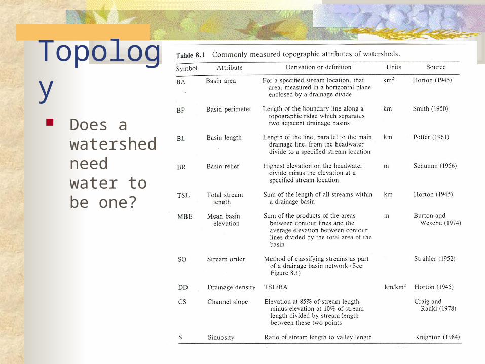
Topology Does a
watershed need water to be one?

Evolution of dynamic understanding RCC Watershed Landscapes Structure and function of multidimensional
systems ecological processes Human impacts versus natural variation

Anaxagoras of Clazomenenae (500-428 B.C.)
“Rivers depend for their existence on the rains and on the waters within the earth, as the earth is hollow, and the water in its cavities”

Function of a watershed=produce water Flow regime
Quantity (magnitude and duration) Timing (duration and frequency)
Quality-or nutrient budgets
Factors that control streamflow Climate Topography Geology Vegetation

Riparian-Upland interactions Most dynamic component of watersheds
Diverse areas; based on disturbance and heterogeneity of habitats
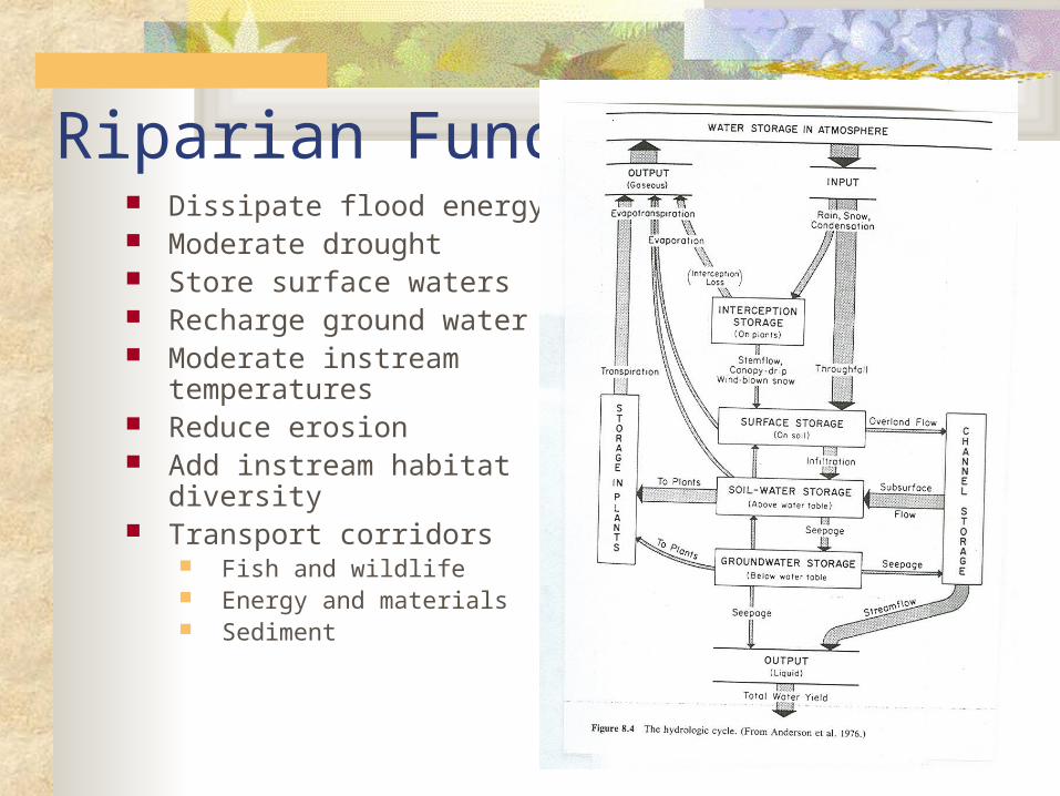
Riparian Function Dissipate flood energy Moderate drought Store surface waters Recharge ground water Moderate instream
temperatures Reduce erosion Add instream habitat diversity Transport corridors
Fish and wildlife Energy and materials Sediment

Riparian-River interactions Size and number of pools
LWD, boulders from upslope areas Regulate sediment inputs via riparian
vegetation

Riparian - Vegetation Function of climate, soils, topography and
land use Controls timing and amount of water yield Controls amount of soil for downstream
transport
Example 48 inches of rainfall (P); 1000 acre watershed
50% is realized as streamflow (48 x 0.5 =24 inches)
Total volume of water yield/year =2,000 acre feet (24 inches x 1,000 acres x 1 ft/12 inches)
Average discharge/year = 2.72 cfs (2,000 acre feet/year x 43,560 ft2/acre-ft x 1yr/365d x 1d/86,400 s)

US precipitation-annual average = 30 inches
4.75 billion acre-feet 3.4 billion (70%) lost to ET
3% lost consumptively, remaining 27% is streamflow In general, the % of precipitation resulting in
streamflow increases with increased precipitation. ET is the most constant variable in the water equation.
When requirement met, the rest is available for runoff. As elevation increases, runoff increases Water supply problems often are not related to water
quantity; timing is important

Channel morphology Strait river channel Meandering river channel
http://earthsci.terc.edu/content/visualizations/es1306/es1306page01.cfm?chapter_no=13
Braided river channel

Strait river channel

Braided river channels

Meandering river channels

Name that river…..

Erosion and sediment transport Sediment is a major product of watersheds
Important to measure Estimated 80% of WQ degradation results from
erosion Sediment interacts strongly with other WQ
components Sediment yield is directly affected by land use
activities Erosion is removal and sedimentation is
deposition

Types of erosion Surface Mass movement Channel cutting
Stream power = the rate at which a stream does work


Restore and protect = priority Importance of riparian zones outweighs the
minor proportion they comprise in the watershed.
National priority: NRC 1992 Broad perspective needed (watershed)
Scale? Must identify key ecological processes that
historically provided structure and function

Water balance equation P = R + ET + S
Where: P = precipitation during time interval t R = total water yield or streamflow at t ET = Evapotranspiration at t
S = storage as t , S approachs zero
Rearrange R = P – ET - S

ET
Transpiration and evaporation are difficult to measure
Equation for ET


The Etowah Regional Habitat Conservation Plan
The unique fish of the Etowah face an uncertain future as rapid development degrades their habitat. Federal regulations to protect the fish can impose costly delays and restrictions on growth. The solution is to develop a regional Habitat Conservation Plan that minimizes the impacts of growth, ensuring long-term environmental and economic health for the region.
http://www.etowahhcp.org/index.html


Counties:
Bartow County
Cherokee County
Cobb County
Dawson County
Forsyth County
Lumpkin County
Paulding County
Pickens County
Cities:
City of Canton
City of Cartersville
City of Dallas
City of Dawsonville
City of Emerson
City of Holly Springs
City of Kennesaw
City of Marietta
City of Roswell
City of Waleska
City of Woodstock
PartnersOther Agencies and Organizations:
Atlanta Regional Commission
Cherokee County Water & Sewer Authority
Chestatee-Chattahoochee Resource Conservation & Development Center
Etowah Water & Sewer Authority
The Georgia Conservancy
Georgia Department of Natural Resources
Georgia Land Trust
Georgia Mountains Regional Development Center
Georgia Regional Transportation Authority
Kennesaw State University
Lake Allatoona Preservation Authority
Limestone Valley Resource Conservation & Development Center
Mountain Conservation Trust of Georgia
The Nature Conservancy
U.S. Army Corps of Engineers
U.S. Fish & Wildlife Service
University of Georgia
Upper Etowah River Alliance

