watershed planning - pwea.org planning ... • restoration plans and tmdl’s • assessment of...
TRANSCRIPT

Byron Madigan
Water Resources Supervisor
Bureau of Resource Management
Carroll County, MD
Watershed Planning “From Assessment to Implementation”


Introduction
• NPDES Background
• Next Generation Permit
• Issued December, 2014
• Urban Wasteload Allocation
• Water Resources Coordination Council (WRCC)
• Carroll County Government
• Carroll County Health Department
• Eight (8) Municipalities
• Memorandum of Agreement (MOA)

County & Municipal MOA
• Phase II requirements
• Purpose
• Cost Share
• County share (80%)
• Municipal share
• Annual payment
• County Responsibility
• Permit Administration/Compliance
• Municipal Responsibility
• Permit compliance support/assistance

Watershed Planning
• NPDES Requirements (Monitoring & Assessment)
• Stream Corridor Assessments (SCA)
• Implementation Strategies
• Restoration Plans and TMDL’s
• Assessment of Controls (discharge characterization)
• Chemical Monitoring
• Biological Monitoring
• Physical/geomorphic monitoring
• I.D.D.E. Sampling

• Provide sufficient data for each problem to determine severity and correctability.
• Prioritize restoration efforts based on information collected for each impairment.
What are the objectives of the SCA?
• Provide list of observable environmental problems within a stream and along its corridors.

Potential Impairments
Erosion
Channel Alteration
Inadequate Buffer
Trash Dumps
Exposed Pipes and Pipe Outfalls
Fish Blockages
Unusual Conditions
In-Stream Construction
Not Carroll County

Prioritizing
Additional Information Collected:
• Adjacent Land Use
• Possible Cause
• Livestock Present
• Erosion Extent (length/Height)
• Type (Erosion attribute)
• Downcut, headcut, or widening
• Threat to infrastructure (Erosion)
• Presence of Utilities (Buffer)
• Location Plantable?
• Blockage Type (Fish Barrier)
• Type of Alteration
• Location of Exposed Pipe
• Bottom of stream, streambank
Impairment Ratings 1) Severity:
1= Most Severe (wide reaching impact on aquatic life) 5= Least Severe (very little impact to stream corridor)
2) Correctability:
1= Minor (fixable with hand labor) 5= Major (require heavy equipment and significant funding
3) Accessibility
1= Easily accessible by car or on foot 5= Difficult to access by foot

Stream Corridor Assessments
Watersheds Assessed
8-Digit Watershed
Major Basin Miles
Assessed Total Miles % Assessed
Year Assessed
Prettyboy Gunpowder 80 97 82% 2011
Liberty Patapsco 255 458 56% 2012
South Branch Patapsco
Patapsco 156 218 72% 2013
Lower N. Branch
Patapsco
Patapsco 6 6 100% 2014
Lower Monocacy
Monocacy/Potomac 10 23 43% 2014
Conewago Creek
Susquehanna 11 18 61% 2014
Upper Monocacy
Monocacy/Potomac 70 128 55% 2015
Total: 588 948 62%
Watersheds To Be Assessed
8-Digit Watershed
Major Basin Miles
Assessed Total Miles % Assessed
Year Assessed
Double Pipe Monocacy/Potomac 529 2016

SCA Initiatives
• Roads Department
• Collapsed/Undersized Culverts
• County/Municipal Utilities
• Exposed Sewer Pipes
• Erosion/Outfall Analysis
• GIS + Upland Survey
• MS4 Storm Drain Network
• Stream Buffer Initiative
• Governor’s Stream Restoration Challenge


Stream Buffer Initiative Prettyboy Watershed • 4.74 Acres • Spring 2013
Liberty Watershed • 13.56 Acres • Spring 2014
South Branch Patapsco • 9.43 Acres • Fall 2014
Fall 2015- 22 additional acres being implemented
Lower Monocacy • 12 Acres • Fall 2013
Upper Monocacy • 13.7 Acres • Fall 2014
Double Pipe Creek • 32.4 Acres • Fall 2014/Spring 2015

• Annual MS4 Questionnaire
• Alternative BMP’s
• WWTP Connections
• Street sweeping/Inlet cleaning
• Impervious to pervious
• Health Department
• Septic Upgrades
• Center for Watershed Protection
• Document Review
• Modeling (Mapshed)
• Accounting for Stormwater (MDE)
• Monitoring Efforts
• Innovative/alternative BMP’s
• Maintenance Facility
• Expert Panel Protocols
• Protocol 1 (Prevented Sediment)
• Additional Monitoring Programs
Restoration Planning
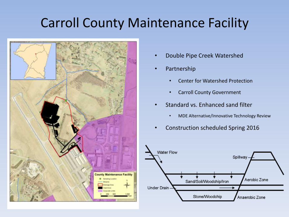
Carroll County Maintenance Facility
• Double Pipe Creek Watershed
• Partnership
• Center for Watershed Protection
• Carroll County Government
• Standard vs. Enhanced sand filter
• MDE Alternative/Innovative Technology Review
• Construction scheduled Spring 2016


Carroll County Monitoring Programs
• NPDES Monitoring
• Retrofit Locations
• Double Pipe Creek
• Prettyboy Watershed
• South Branch Patapsco
• Bacteria Monitoring
• Liberty Watershed
• Prettyboy Watershed
• Storm Event Monitoring
• Carroll County Maintenance Facility
• MBSS Locations
• Maryland Biological Stream Survey
• Piney Run Reservoir

NPDES Monitoring • Liberty Watershed
• Airport Facility
• 563 Acre D.A., 140 Acre I.A. (25%)
• 28% Commercial/Industrial

Retrofit Monitoring
Double Pipe Creek
• Manchester Skate Park
• Sampled Bi-weekly
• TSS, OP, NO32, TP
• Spring MBSS
Land Use:
• Drainage Area: 99 Acres
• Impervious: 24 Acres (24%)
• Dominant Land Use: Residential (37%)
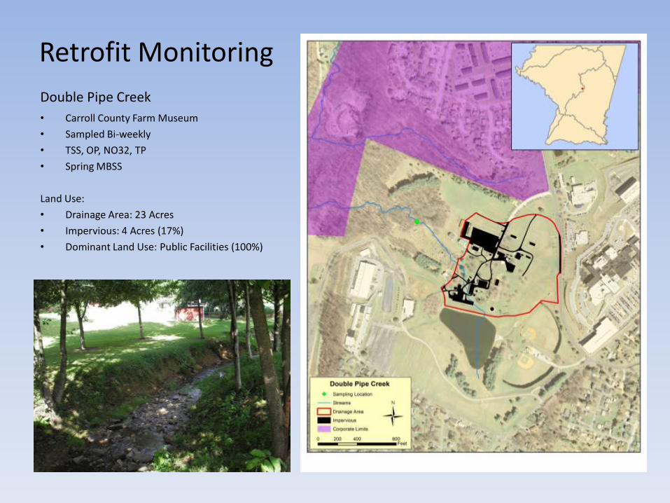
Retrofit Monitoring
Double Pipe Creek
• Carroll County Farm Museum
• Sampled Bi-weekly
• TSS, OP, NO32, TP
• Spring MBSS
Land Use:
• Drainage Area: 23 Acres
• Impervious: 4 Acres (17%)
• Dominant Land Use: Public Facilities (100%)

Retrofit Monitoring
Prettyboy Watershed
• Whispering Valley Phase IV
• Sampled Bi-weekly
• TSS, OP, NO32, TP
• Spring MBSS
• Cross Sectional Surveys
Land Use:
• Drainage Area: 95 Acres
• Impervious: 19 Acres (20%)
• Dominant Land Use: Residential (84%)

Retrofit Monitoring • South Branch Patapsco
• Shannon Run/Hawks Ridge
• Sampled Bi-weekly
• TSS, OP, NO32, TP
• Spring MBSS
Land Use:
• Drainage Area: 209 Acres
• Impervious: 42 Acres (20%)
• Dominant Land Use: Residential (63%)

Retrofit Monitoring • South Branch Patapsco
• Eldersburg Estates
• TSS, OP, NO32, TP
• Storm Event Monitoring
• Spring MBSS
• Cross Sectional Surveys
Land Use:
• Drainage Area: 30 Acres
• Impervious: 9 Acres (30%)
• Dominant Land Use: Residential (73%)

Bacteria Monitoring
Liberty Watershed
• Sampled Monthly
• 5 main sub-sheds
• Conjunction with Baltimore County
• 2015 program expansion

MBSS Locations
Double Pipe Creek (13 Sites)
• Retrofit monitoring (4)
• Union Mills (9)
South Branch Patapsco (15 Sites) • Retrofit Monitoring (3)
• Piney Run (7)
• Gillis Falls (5)
Liberty Reservoir (4 Sites) • Retrofit Monitoring (2)
• NPDES Monitoring (2)
Prettyboy Reservoir (5 Sites) • Retrofit Monitoring (1)
• Prettyboy Temperature/Trout Study (4)
• 2009/2010
• DNR Inland Fisheries
• Baltimore County DEPRM

Piney Run Reservoir • Reservoir Profile
• Bi-weekly
• April-November
• OP, TP, NO32, NH3, TKN, Chl-A, E-coli, Fe, Mg
• pH, Temp, D.O., Sp. Conductance, Turbidity
• Plankton and Zooplankton
• Sediment Core Analysis • Soluble Reactive Phosphorus
• Seasonal Analysis
• December 2014
• April and August 2015

Thank You!
Thank You!