water quality classifications £¤ goshen, ct
TRANSCRIPT
!n
!H
!n
!n
!o
!n
!n
!n
!n
!n
G O S H EN
CO R N W A LL
T O R R IN G T O N
LIT CH FIELD
CA N A A NN O R FO LK
W IN CH E S T E R
W A R R ENH A R W IN T O N
S H A R O N
S A LIS B U R Y
AA
AA
AA
AA
B
AA
AA
AA
AA
AA
B
AA
West Goshen
West Cornwall
Newberry Corner
West Torrington
Winchester Center
Tyler Lake Heights
Pie Hill
Overlook
Town Hill
Pond Hill
Rugg Hill
Dean Hill
Grant Hill
Beech Hill
White Rock
The Cobble
Riggs Hill
Besse Hill
Lucas Hill
Cream Hill
Brush Hill
Platt Hill
Brandy Hill
School Hill
Quarry Hill
Waller Hill
Parker Hill
The Hogback
Cherry Hill
Turtle Rock
Tarradiddle
Dean Ravine
Tibbals Hill
Red Mountain
Cream Hollow
The Pinnacle
Ivy Mountain
Red Mountain
Roberts Hill
Mount Ouleout
Jennings Hill
Howe Mountain
Lookout Point
Buck Mountain The Ballyhack
Rebekahs Hill
The Ballyhack
Peck Mountain
Johnson Hollow
Green Mountain
Music Mountain
Brass Mountain
Titus Mountain
Hough Mountain
Bloody Mountain
Dudleytown Hill
Mohawk Mountain
Walnut Mountain
Bartholomew Hill
Rattlesnake Hill
Barrack Mountain
Sedgwick Mountain
Woodbury Mountain
Coltsfoot Mountain
A
B
AA
B
A
B
B
A
A
B
AA
Gunn Dam
Hare Dam
Dog Pond
Mad River
Fox Brook
Fox Brook
Catch Dam
Smith Dam
Penn Pond
Park Pond
Hart Pond
Troy Brook
Rugg Brook
Reed Brook
Reed Brook
Reed Brook
Mill Brook
Hart Brook
Flat Brook
Whist Pond
Spruce Dam
Tyler Lake
Ocain Pond
North Pond
Goose Pond
Clark Pond
Beebe Pond
Long Swamp
Peat Swamp
Blue Swamp
Bear Swamp
Bear Swamp
Bear Swamp
Pitch Brook
Ocain Brook
Jakes Brook
Gulf Stream
Gulf Stream
Brown Brook
Adams Brook
Wilcox Pond
Wapato Pond
Wampee Pond
Calhoun Dam
Nasers Pond
Mohawk Pond
Miscus Pond
Migeon Pond
Meadow Lake
Lake Floren
Hoover Pond
Hedden Pond
Childs Pond
Bantam Pond
Hall Meadow
Grant Swamp
Valley Brook
Taylor Brook
Tanner Brook
Sucker Brook
Sucker Brook
Spruce Brook
Spruce Brook
Mohawk Brook
Bloody Brook
Bantam River
Bantam River
Wildcat Pond
Springs Pond
Ouleout Lake
Lincoln Pond
Kussell Pond
Iffland Pond
Hurlbut Pond
Hawkins Pond
Guerdat Pond
Goodwin Pond
Crystal Lake
Spruce Swamp
Preston Brook
Pickett Brook
Heffers Brook
Furnace Brook
Baldwin Brook
Scoville Pond
Marshall Lake
Beechers Pond
Perkins Swamp
Wildcat Swamp
Bradford Brook
Birdseye Brook
West Side Pond
Fitzgerald Dam
Livingston Dam
Patterson Pond
Denenberg Pond
Naugatuck River
Naugatuck River
Moulthrop BrookButternut Brook
Woodbridge Lake
Stillwater Pond
Silas Hall Pond
Lake Winchester
Hollenbeck Pond
Cunningham Pond
Cream Hill Lake
Besse Park Pond
Bear Swamp Pond
Marshepaug River
Housatonic River
Hollenbeck River
Drake Pond Brook
Cairns Reservoir
Black Spruce Bog
Riley Swamp Brook
Nickel Mine Brook
Lovers Lane Brook
Hall Meadow Brook
Hall Meadow Brook
Ivy Mountain Pond
Gilette Reservoir
The Cranberry Bog
Sanders Hill Brook
Ivy Mountain Brook
Camp Freedman Pond
Camp Delaware Pond
Marshall Lake Brook
Allen Dam Reservoir
West Side Pond Brook
Winchester Club Pond
Rugg Brook Reservoir
Litchfield Reservoir
Hart Brook Reservoir
Reuben Hart Reservoir
Hatchaluchi Reservoir
Crystal Lake Reservoir
West Branch Bantam River
West Branch Bantam River
North Branch Brown Brook
Warrenton Woolen Co Pond
West Branch Shepaug River
West Branch Shepaug River
East Branch Shepaug River
Conn Junior Republic Pond
West Branch Naugatuck River
West Branch Butternut Brook
East Branch Naugatuck River
East Branch Naugatuck River
Hall Meadow Brook Reservoir
Wings Ago AirstripAirport
Charlotte Hungerford Hospital
Forbes School
Southwest School
Vogel-Wetmore School
Goshen Center School
Cornwall Consolidated
Torrington High School
Housatonic Valley Regional High
Oliver Wolcott Technical High School
East St
Beach St
North St
State Hwy 272
State Hwy 4
Town
St
Newf
ield R
d
Norfo
lk Rd
State
Hwy 8
State Hwy 63
US Hwy 202
State
Hwy 4
3
River Rd
Yates Rd
Mountain Rd
Weed
Rd
Maple St
Route 63
Cornw
all Ho
llow Rd
Sharon Tpke
State Hwy 263
Milton Rd
Old Middle St
Lake R
d
Highland Ave
Guerd
at Rd
Blue St
Goshen Rd
Gran
tville
Rd
West Rd
College St
West St
Crea
m Hil
l Rd
Torrin
gton R
d
Litchfield Rd
Meliu
s Rd
State Hwy 128
Clark Rd
Elm St
State Hwy 45
South Rd
Flat Rocks Rd
Great Hill Rd
Great
Hollow
Rd
James
H Da
rcey M
emori
al Hwy
Lake S
t
Platt H
ill Rd
Bruey Rd
Winchester Rd
Wadh
ams R
d
Haas Rd
Main
St
Eishner Rd
Pothi
er Rd
Eli Bunk
er Rd
Fern
Rd
State Hwy 118
Estey
Rd
Valley
Rd
Sharon Goshen Tpke
Rugg
Broo
k Rd
Toumey Rd
Litchfield Tpke
Furnace Brook Rd
Westside Rd
Allen Rd
Fern Ave
Litchfield St
Gold R
d
Unive
rsity
Dr
Dibble Hill Rd
Pie Hill Rd
Ashley Rd
State F
orest R
d
5 1/2 Mile Rd
Old Wate
rbury T
pke
Goodhouse Rd
Music Mountain Rd
Town Hill Rd
Town Farm Rd
Hall Meadow Rd
Migeon Ave
Wheeler Rd
Hageman Shean Rd
Winsted R
d
Weigold Rd
Blue Swamp Rd
Bunker Hill Rd
Richard
Rd
Cornwall Rd
Parker Hill Rd
Seeley Rd
Huntsville South Canaan Rd
Chapel Rd
High St
Old Goshen Rd
Pierce
Ln
Wilson Rd
Allyn Rd
Ives Rd
Brandy Hill Rd
School Hill Rd
Pearl St
Saw M
ill Hill R
d
Devaux Rd
Gray Ln
Naser Rd
Riverside Ave
Marshall Lake Rd
Kubis
h Rd
Klug Hill Rd
Albert St
Titus M
t Rd
Love
rs Ln
Hyerdale Dr
Hollenbeck Rd
Starks Rd
Gran
ge H
all R
d
State Hwy 125
Cogswell Rd
Headquarters Rd
Mund
ry Rd
Camp
Rd
Preston
Rd
Laurel Way
Scov
ille H
ill Rd
New Litchfield St
Bear
Swam
p Rd
Wellsford Dr
Whist Pond Rd
Newcomb Rd
Ivy M
ounta
in Rd
Stillw
ater P
ond R
d
Wahnee Rd
Bogue Rd
Lowe
r Barr
ack R
d
Hart Dr
Tim Wall Rd
Hall Rd
Brooks Rd
Dudle
ytown
Rd
Mansfiel
d Rd
Oak Ave
Taylor Brook Rd
Saw Mill Rd
Bartholomew Hill Rd
Seherr Thoss Dr
Wickwire Rd
Ford Hill Rd
Mike Rd
Hillhouse Rd
Winthrop St
Park Ave
Cherry Hill Rd
Under Mountain Rd
Howe Rd
Ripley Rd
John Brown Rd
Deming Rd
Popple Swamp Rd
Clearv
iew Av
e
Danb
ury Q
uarte
r Rd
Goshen East St
Castle Rd
Dayton Rd
Lyman Ln
Stone
ridge
Dr
Lime Rock Sta
Potash Rd
Scoville Rd
Birch Hill Rd
Hemlock Hill Rd
Shear Shop Rd
Hutch
inson
Pkw
y
Shearshop Rd
Pine S
t
Holmes Rd
Soapstone Hill Rd
Whiting Rd
Thom
aston
Rd
Fox R
d
Hillside Ave
Funston Ave
Lime Rock Rd
Cliffside Dr
Meyer Rd
Rattlesnake Rd
Ashley Dr
Jewel St
Cemetery Hill Rd
Weldon Ct
Rossi Rd
East Elm St
Hautboy Hill Rd
Johns
on Rd
Osbo
rn Rd
Highview Dr
Westside Ln
Daley
Dr
Windy Ridge Rd
US Hwy 44
Barn Rd
Aetna Ave
Keith Rd
Brush Hill Rd
Perkins Rd
Peck Rd
Sherbro
ok Dr
Eno A
ve
Prospect St
Kinne
y St
Bradford Rd
Shelbourne Dr
Yelping Hill Rd
Hollow Rd
Field
St
Mohawk Mountain Rd
24 Bumper Rd
Warre
n Litch
field
Rd
Roberts St
Schoolhouse Rd
Weed St
Route 7 Warren Tpke
Forest St
Bigos Rd
Meekert
own R
d
Weibold Rd
Essex Hill Rd
Sandy Beach Rd
Barto
n St
Spring St
Culvert St
Turkey Hollow Ln
Litwin R
d
Talmadge Ln
Everest Hill Rd
John A Minetto Park Rd
Berry St
Todd
Hill R
d
Darlin
g St
Rexford Rd
Wyoming Ave
Wimbledon Gate
Arthur St
Garde
n St
Hassig StMcKinley St
Beebe Hill Rd
Clarence St
Charl
es St
Hyde St
Patte
rson S
t
US Hwy 7
Butternut Rd
Millard St
Wall StBare Hill Rd
Heights Dr
Pumping Station Rd
Lois St
Hill St
Cobble Rd
Red Mountain Ave
Reservoir Rd
Crossman Rd
Calhoun St
Sarck
a Ln
Cardinal Cir
Hollow Hill Rd
Kimberly Rd
Notting Hill Gate
Grov
e St
Linton St
Johnson St
Martha St
Laurel Hill Rd
Birden St
Bentl
ey C
ir
Paxto
n Ct
Central Ave
View
St Wood St
Hodges Hill Rd
Page Rd
Seely
Ln
Chapel St
Hunte
r Dr
Alice St
Anaconda Rd
Carria
ge Ln
Hurlbut Pl
Jakes
Rd
Montfort Rd
Laurel Rd
Old Route 7
Wright Hill Rd
Roosevelt Ave
Old Dump Rd
Thompson Rd
Franklin St
Prichard Rd
Dog Pond Rd
Pierce St
Bolton Hill Rd
Hoffman St
Schuman St
Cante
rbury
Ct
Park
Rd
Blackland Rd
Tamarack Ln
Oakbrook Ln
Perki
ns H
ill Rd
Kirk Rd
Hall Meadow Ln
Church St
Starview Dr
Hardscrabble Rd
Arel Dr
Rock Hous
e Rd
Brick School Rd
Franklin Dr
Pulaski St
Beech Hill Rd
Westled
ge Dr
Brynmoor Dr
Summer St
Paughnut Rd
Aspen Hill Dr
Pithian Ave
Hinsdale Rd
Maple View Trl
Cornwall DrAd
ams R
d
Stone Hill Rd
Mill St
Litchfield Holw
Trailse
nd Dr
Caulfield Rd
Reverie Ln
Clark Hill Rd
Rockwall
Ct
Buefo
rd Ct
Siloe Rd
Bruno Rd
Hill Top Dr
Turner Ave
Northridge Ave
Meadowcrest
Scoville St
Laurel Mountain Rd
Ethan Allen Rd
Stonebridge Ln
Taylor St
Brynmoor Ct
Davidson Rd
Cobb
le Hil
l Rd
Workman Ave
Clark St
Harwinton Ave
Sucke
r Broo
k Rd
Fern DrBird St
West Dr
Wilmot St
Home
stead
Rd
Arnott Dr
Breguet Rd
Perkins St
Walnut St
Poughkeepsie Rd
Bann
on St
Surre
y Ln
Newfield Spring Rd
Apley Rd
Four Winds Rd
Holley Pl
Calli St
Elsie St
Hurley St
Toll Gate Rd
Center Rd
Lucas Rd
Farley Pl
Arbor Dr
Woodbine St
Millbrook Ln
Mill Ln
Reed
Broo
k Rd
Baron Ln
Elton St
Cook St
Craig Ln
Jackson St
Ford Ln
Dresden
Cir
Travis St
Ifflan
d Pon
d Rd
Bridle Path Rd
Wadsworth Rd
Colt Ave
James St
Forman Peirce Dr
The Way
Pond Ridge Dr
Brook Hill Rd
Ledge Dr
Silver Brook Ln
Palmer Bridge St
Essex Ct
Hidden Pond Ln
Wrigh
t Rd
Smith St
Private Rd
Spruce Dr
Beecher Ln
Greenfield Dr
Avenue A
Hoerl
e Blvd
Hubb
ard Pn
es
Rock
y Cov
e Ln
Birchwood Ln
Upper Barrack Rd
Mortimer St
Marshepaug Rd
Coolidge Ave
Litchfield Ln
Borou
gh St
Deer Run Ln
Zappula Dr
Comm
ercial
Blvd
Chester St
Bexle
y Ct
Bisho
p St
Lincoln Pl
Orchard Ln
Benjamin Ct
Bertoli Dr
Chels
ea C
t
Evans St
Brooker St
Woodruff Ln
Evergreen Rd
Stone
hous
e Rd
Sutton Ct
Barba
ret Rd
Planet St
Wynwood Ct
Broad St
Mountain View Mnr
Crystal Ln
White Oak Ln
Maud St
Dewey St
Hardy St
Lipton Pl
Battistoni Dr
Eichn
er St
Apple
St
Lauran
ti Ln
Suns
et Dr
Daycoeton Pl
Meen
ahga
Ln
Westled
ge Ter
State Dr
Country Pl
Timberlake Ct
Bancroft St
Howe Rd
Goshen Rd
State
Hwy 8
Peck Rd
West Rd
Barn Rd
Litchfield Rd
South Rd
Brush Hill Rd
East
St
Johnso
n Rd
Spruce Dr
East St
US H
wy 7
Johnson Rd
Meekertown Rd
Winchester Rd
Hardscrabble Rd
Norfolk Rd
Milton Rd
Cornw
all R
d
Clark
Rd
Litchfield Rd
North St
Town
St
Route
7
Torrington Rd
Great Hollow Rd
Ivy Mountain Rd
Richard Rd
Route
7
Milton Rd
Goshen Rd
Exit 42
Exit 44
Exit 43
Exit 45
Exit 43
Exit 44
Exit 42£¤202
£¤7
£¤44
£¤7
SV43
SV63
SV272
SV4
SV263
SV128
SV118
SV125
SV45
SV8
SV63
SV4
SV8
MAP LOCATION
GoshenGoshen
W ATER Q UALITY CLAS S IFICATIONSGOSHEN, CT
SCALE 1:24,000 (1 inch = 2000 feet) when map is printed at original size
1 0 10.5 Miles
1 0 10.5 Kilometers
1000 0 1000 2000 3000 4000 5000 6000 7000 Feet
ADOPTED DATES
W ater Q uality S tandardsFebruary 25, 2011
Thames R iver, Pawcatuck R iver and Southeast CoastalBasins: December 1986
Connecticut R iver and South Central Coastal Basins:February 1993
Housatonic R iver, Hudson R iver and Southw est CoastalBasins: March 1999
S TATE OF CONNECTICUTDEPAR TMENT OFENER GY & ENV IR ONMENTAL PR OTECTION79 Elm S treetHartford, CT 06106-5127
State Plane Coordinate System of 1983, Zone 3526Lambert Conformal Conic Projection
North American Datum of 1983
MAJOR BASINS1 Paw catuck2 Southeast Coast3 Thames4 Connecticut5 South Central Coast6 Housatonic7 Southw est Coast8 Hudson
£
S UR FACE W ATER Q UALITY CLAS S ES
Final Aquifer Protection Area (Level A)Major Basin Boundary
GR OUND W ATER Q UALITY CLAS SES
NOTES:S urface W ater Classifications beginning w ith S refer to Coastal and Marine S urface W ater.B* is a subset of Class B where no direct w astew ater discharges are allow ed other than thoseconsistent with Class AA, A and SA surface w aters.
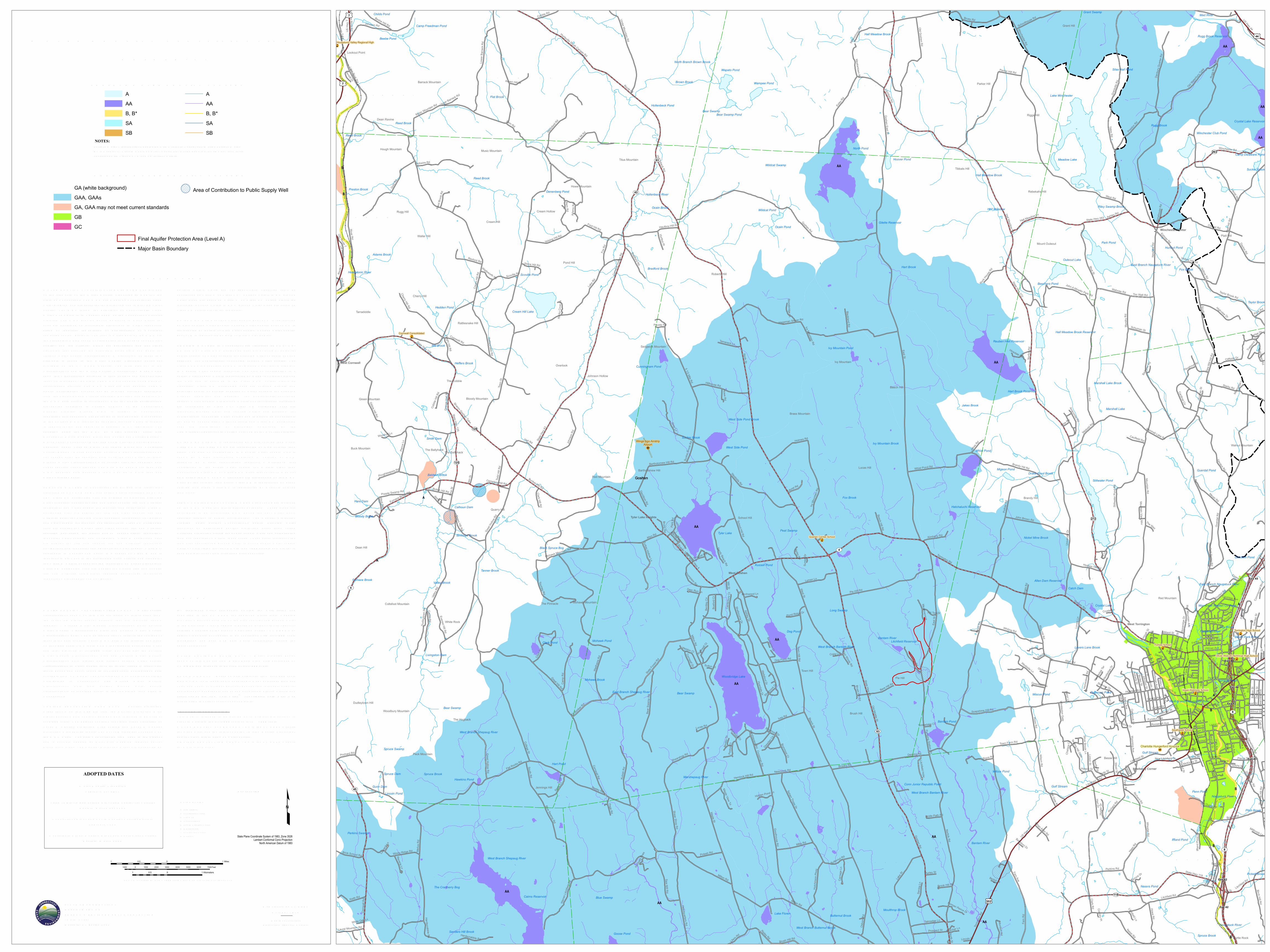
GA (white background)GAA, GAAsGA, GAA may not meet current standardsGBGC
Area of Contribution to Public Supply Well
AAAB, B*SASB
AAAB, B*SASB
EX PLANATIONW ATER Q UALITY CLAS S IFICATIONS (W Q C) MAPS are oneof the elements of the W ater Q uality S tandards (W Q S ) for theS tate of Connecticut. The W Q S are a part of Connecticut's cleanw ater program and are essential for protecting and improving waterquality. The W Q S follow the principles of Connecticut's CleanW ater Act which is in Chapter 446K of the Connecticut GeneralS tatutes. The W Q S provide policy guidance in many areas, forexample decisions on acceptable discharges to water resources,siting of landfills, remediation or prioritization of municipalsew erage system projects. The first two elements of the W Q S arethe S tandards, which set an overall policy for management of waterquality, and the Criteria, which are descriptive and numericalstandards that describe the allowable parameters and goals forvarious water quality classifications. A discussion of these twoelements is found in the W ater Q uality S tandards documentavailable on the CT DEEP website. The third element is theClassifications and the W ater Q uality Classification Maps whichshow the Classification assigned to each surface and groundw aterresource throughout the S tate. The W Q S are adopted using a publicparticipation process. The W Q C maps are also adopted using apublic participation process but go through hearings separatelyfrom the S tandards and Criteria hearings. R evision and adoption ofthe W Q C data occurs in accordance with the public participationprocedures contained in S ection 22a-426 of the ConnecticutGeneral S tatutes. Ground W Q C is subject to Connecticutregulation and changes must be review ed and adopted. All changesto the S urface W Q C require an adoption process which is subjectto federal review and approval in addition to CT regulation. Theadoption dates for the W Q C by major drainage basin are:Housatonic R iver, Hudson R iver and Southw est Coastal Basins -March 1999; Connecticut R iver and South Central Coastal Basins -February 1993; Thames R iver, Pawcatuck R iver and SoutheastCoastal Basins - December 1986. S urface W ater Classifications donot change after the adoption date until the next major revision.Ground W ater Classifications may change after the adoption dateunder specific circumstances. The map may have more than oneW Q C adoption date because a town may be in more than onemajor drainage basin.SUR FACE W ATER S in Connecticut are divided into freshw aterclassified as AA, A, B or B* and saline waters classified as SA orSB. Class AA designated uses are existing or proposed drink ingw ater supplies; habitat for fish and other aquatic life and wildlife;recreation; and water supply for industry and agriculture. Class Adesignated uses are habitat for fish and other aquatic life andw ildlife; potential drink ing water supplies; recreation; navigation;and water supply for industry and agriculture. Class SA designateduses are habitat for marine fish, other aquatic life and wildlife;shellfish harvesting for direct human consumption; recreation;industrial water supply; and navigation. Class B designated usesare habitat for fish and aquatic life and wildlife; recreation;navigation; and industrial and agricultural water supply. Class B*,applicable to Candlewood Lak e, is a subset of Class B and isidentical in all ways to the designated uses, criteria and standardsfor Class B waters except for the restriction on direct discharges.Class SB designated uses are habitat for marine fish and aquaticlife and wildlife; commercial shellfish harvesting; recreation;industrial water supply; and navigation.
S urface waters which are not specifically classified shall beconsidered as Class A or Class AA. S urface waters in GA groundw ater areas are assumed Class A or Class SA unless otherwiseindicated. S urface waters in GAA ground water areas are assumedClass AA unless otherwise indicated.On the W Q C map a surface water quality goal of A is representedby blue colored water bodies. S urface water quality goal of AA isrepresented by purple colored water bodies. S urface water qualitygoal of B is represented by gold colored water bodies.GR OUND W ATER S in Connecticut are classified as GAA, GA,GB and GC. Class GAA designated uses are existing or potentialpublic supply of w ater suitable for drink ing without treatment andbaseflow for hydraulically-connected surface water bodies. TheClass GAAs is a subclass of GAA for ground water that is tributaryto a public water supply reservoir. The area of contribution to apublic water supply well is represented by a 500-foot radius aroundthe well and is assumed to be Class GAA unless otherwiseclassified. Class GA designated uses are existing private andpotential public or private supplies of water suitable for drink ingw ithout treatment and baseflow for hydraulically-connectedsurface water bodies. All ground waters not specifically classifiedare considered as Class GA. Class GB designated uses areindustrial process water and cooling waters and baseflow forhydraulically-connected water bodies and is presumed not suitablefor human consumption without treatment. Class GC designateduses are assimilation of discharges authorized by theCommissioner pursuant to S ection 22a-430 of the General S tatutes.On the W Q C map GA is represented by white colored land areas.Class GAA and class GAAs are represented by blue colored landareas. The area of contribution to a public water supply well isshown by a blue cross-hatch overprint. A notation of GAAfollowed by a state abbreviation indicates a watershed thatcontributes to the public water supply for a state other thanConnecticut. Class GA or Class GAA areas that currently may notbe meeting the GA or GAA standards are represented on the W Q Cmaps by tan colored land areas. Class GB is represented by greencolored land areas. Class GC is represented by magenta coloredland areas.FINAL AQ UIFER PR OTECTION AR EAS (Level A) are includedon the W Q C maps for informational purposes. These areas areanticipated to be reclassified GAA during the next major basinupdates, subject to public participation. The Aquifer ProtectionProgram helps protect Connecticut’s public drink ing waterresources by delineating aquifer protection areas (also calledw ellhead protection areas) for public supply wells and establishingland use regulations within these areas. These areas represent theland area contributing ground water to active public water supplywells or well fields that serve more than 1000 people and are set insand and gravel aquifers (stratified drift deposits).
DATA SOUR CESW ATER Q UALITY CLAS S IFICATIONS DATA – W ater qualityclassifications shown on this map are based on information fromthe following digital spatial datasets that are typically showntogether – Ground W ater Q uality Classifications Poly, S urfaceW ater Q uality Classifications Line, and S urface W ater Q ualityClassifications Poly. The map legend above reflects the content ofthese three data sources. These W Q C data were initially compiledon 1:24,000-scale 7.5 minute USGS topographic quadrangle mapsand later digitized at 1:24,000 scale. For example, the S urfaceW ater Q uality Classifications Line and S urface W ater Q ualityClassifications Poly digital data assigns surface water qualityclassifications to water bodies such as rivers, streams, reservoirs,lak es, ponds and coves found in 1:24,000-scale hydrography dataavailable from CT DEEP. The hydrography may not include all thew aterbodies in Connecticut. The Ground W ater Q ualityClassifications Poly data assigns ground water qualityclassifications, at 1:24,000 scale, to the remaining land areas inConnecticut.AQ UIFER PR OTECTION AR EA DATA – Aquifer ProtectionAreas shown on this map are from the Aquifer Protection Areadigital dataset which contains polygon data intended to be used at1:24,000 scale. The dataset contains regulated areas classified asLevel A Aquifer Protection Area (Final) and Level B AquiferProtection Area (Preliminary). The Level B areas are not shown onthe W Q C maps. The data was collected from 1991 to the presentand is actively updated as Final area mapping replaces earlierPreliminary areas. The Aquifer Protection Areas are delineated by
the individual water companies owning the well fields andsubmitted to the CT DEEP for approval. Preliminary mappingprovides a general estimate of the area contributing ground waterto the well field. Final mapping is based on extensive, site-specific,detailed modeling of the ground water flow system. CT DEEP mayadjust Final area boundaries to be consistent with 1:24,000 scaletopography and base map data where appropriate during theapproval process.MAJOR DR AINAGE BASIN DATA – Major drainage basinsshown on this map are from Major Basin Line data developed byCT DEEP and intended to be used at 1:24,000 scale.BASE MAP DATA - Based on data originally from 1:24,000-scaleUSGS 7.5 minute topographic quadrangle maps published betw een1969 and 1992. It includes political boundaries, railroads, airports,hydrography, geographic names and geographic places. S treets andstreet names are from Tele Atlas® copyrighted data. Base mapinformation is neither current nor complete.R ELATED INFOR MATIONThis map is intended to be printed at its original dimensions inorder to maintain the 1:24,000 scale (1 inch = 2000 feet).W ATER Q UALITY S TANDAR DS - Go to the CT DEEP websitefor a summary and the full text of the “W ater Q uality S tandards”and for other information on water quality.AQ UIFER PR OTECTION AR EAS - Go to the CT DEEP websitefor more information.
Map created by CT DEEPOctober 2018Map is not colorfast
Protect from light and moisture