water governance in the yamuna river basin in …re.indiaenvironmentportal.org.in/files/on the...
TRANSCRIPT

For copies and further information, please contact:
PEACE Institute Charitable Trust178-F, Pocket – 4, Mayur Vihar, Phase I, Delhi – 110 091, India
P : 91-11-22719005; E : [email protected]; W: www.peaceinst.org
Water Governance in the Yamuna River Basin in Haryana
August 2010
Society for Promotion of Wastelands Development PEACE Institute Charitable Trust

Published by
PEACE Institute Charitable Trust 178-F, Pocket – 4, Mayur Vihar – I, Delhi – 110 091, INDIATelefax: 91-11-22719005Email: [email protected]: www.peaceinst.org
First Edition, August 2010
© PEACE Institute Charitable Trust
Funded by
Society for Promotion of Wastelands Development (SPWD) under a Sir Dorabji Tata Trust supported Water Governance Project14-A, Vishnu Digambar Marg, New Delhi – 110 002, INDIAPhone: 91-11-23236440Email: [email protected]: www.watergovernanceindia.org
Designed & Printed by: Kriti Communications
DisclaimerPEACE Institute Charitable Trust and Society for Promotion of Wastelands Development (SPWD) cannot be held responsible for errors or consequences arising from the use of information contained in this report.
All rights reserved. Information contained in this report may be used freely with due acknowledgement.

iO n t h e B r i n k . . . W a t e r G o v e r n a n c e i n t h e Ya m u n a R i v e r B a s i n i n H a r y a n a
This publication is a joint effort of:
Amita Bhaduri, Bhim, Hardeep Singh, Manoj Misra, Pushp Jain, Prem Prakash Bhardwaj
&
All participants at the workshop on ‘Water Governance in Yamuna Basin’ held at Panipat
(Haryana) on 26 July 2010
When I am, U r fine.
When I am not, U panic !
When I get frail and sick, U care not ?
(I – water)
– Manoj Misra

ii O n t h e B r i n k . . . W a t e r G o v e r n a n c e i n t h e Ya m u n a R i v e r B a s i n i n H a r y a n a
Acknowledgement
The roots of this study lie in our research and advocacy work for the river Yamuna under a civil society campaign called ‘Yamuna Jiye Abhiyaan’ which has been an ongoing process for the last three and a half years. It was early in our research that we came to understand that the two canals, namely the Western Yamuna Canal (WYC) and the Eastern Yamuna Canal (EYC) originating at the Hathnikund Barrage on river Yamuna held the key to any revival initiative for the river.
So it was with great interest that we accepted the offer of the Society for Promotion of Wastelands Development (SPWD), Delhi to conduct a short term but in-depth study on the water governance situation in the river Yamuna basin in Haryana. We are grateful to Sri Hardeep Singh and Ms Amita Bhaduri of SPWD for reposing their faith in our capabilities. They are also thanked for accompanying and guiding us in the field.
The study of this nature could not be accomplished without a dedicated team of field researchers who would go out of their way to elicit the relevant information, access key documents and network with ease with the government officials, NGOs and the villagers. In Pushp Jain and Bhim we found such an effective team. Their contribution is gratefully acknowledged. In Prem Prakash Bhardwaj a retired official of the Agriculture department, we found a perfect local guide and gracious host at Panipat.
We are grateful to all the officials (at different levels) of the various government departments like Irrigation, CADA, Agriculture (including Ground Water Cell), Public Health, Power, Pollution Control Board, Panchayat, HUDA, Industries, Tourism, Forests, Fisheries etc who agreed to meet us and respond to our queries and requests for information.
We would like to thank the officials of various NGOs like the Sai Seva Samiti (Sonepat), Sonepat Garden Society, Prerna (Sonepat), Azadi Bachao Andolan (Sonepat), Gyan Vigyan Samiti (Sonepat), Yamuna Suraksha Samiti (Panipat), Sarvodaya Sewa Mandal (Panipat), Mata Shitla Rani Sewa Sansthan (Panipat) as well as the scientists at the Krishi Vigyan Kendra, Ujha (Panipat) for their help.
This study could not have been completed without frequent and detailed interactions with the villagers at Sardhana, Dadlana, Shimla Gujran and Khewara. We gratefully acknowledge their cheerful welcome, eagerness and frankness in sharing information and glasses full of milk, much to the delight of Bhim, our intrepid field researcher. We would also like to thank all those persons with whom we interacted at villages Binjhol, Joshi Jaat, Rajlu Garhi and at the STPs at Sonepat and Panipat.
The stakeholder’s workshop held at Panipat on 26 July 2010 was the culmination of the field work and we would like to thank all the participants for their active participation and useful inputs made at the day long meet. Last but not the least the dedicated team consisting of Sudha Mohan and Manorama Goswami at the PEACE Institute office at Delhi is thanked for their efficient support to the field team and assistance in the preparation of the report.
Manoj Misra
iiiO n t h e B r i n k . . . W a t e r G o v e r n a n c e i n t h e Ya m u n a R i v e r B a s i n i n H a r y a n a
Contents
ABBREVIATIONS .................................................................................................................. iv
Chapter 1: Background ....................................................................................................... 8
Chapter 2: Western Yamuna Canal .................................................................................. 11
Chapter 3: Study Area & Methodology ...........................................................................20
Chapter 4: Water Development and Use in Haryana ..................................................... 24
Chapter 5: Study Observations ........................................................................................38
Chapter 6: Study Findings .................................................................................................50
Chapter 7: Trends, Consequences and Options .............................................................66
REFERENCES ........................................................................................................................ 71
LIST OF ANNExURES
1. Water Sharing Agreement between six States ................................................................73
2. A comparative statement of the Rotational Program showing the allocations for Kharif season as on 2001 and 2010 .......................................................75
3. Draft Policy For Rice Shoots For Kharif – 2010 ..............................................................81
4. Details of Field Visits ............................................................................................................85
5. Questionnaire for Village Level Survey ...........................................................................88
6. List of Senior Officials met at Panchkula ..........................................................................92
7. List of Participants at the Workshop on Water Governance .......................................93
8. Memorandum of Agreement between the Punjab and Uttar Pradesh Governments – Regarding Distribution of Supplies at Tajewala Headworks between WYC and EYC .......................................................................................................95

iv O n t h e B r i n k . . . W a t e r G o v e r n a n c e i n t h e Ya m u n a R i v e r B a s i n i n H a r y a n a
BAU Business As UsualBDO Block Development OfficerBHP British Horse PowerBLT BhalautCADA Command Area Development AuthorityCADWM Command Area Development and Water ManagementCCA Cultivable Command AreaCdr CommanderCE Chief EngineerCGWA Central Ground Water AuthorityCGWB Central Ground Water BoardCLC Carrier Lined ChannelCM Chief MinisterCPCB Central Pollution Control BoardCRPF Central Reserve Police Force CSO Civil Society OrganisationCSR Corporate Social ResponsibilityCWC Central Water CommissionDC Deputy CommissionerDCO Divisional Canal OfficerDJB Delhi Jal BoardDN Drain Numberd/s DownstreamDSB Delhi Sub BranchEE Executive EngineerETP Effluent Treatment PlantEYC Eastern Yamuna CanalFC Finance Commissioner FSA Fuel Surcharge AdjustmentFt FeetGOI Government of IndiaGWC Ground Water CellGWS Gurgaon Water SupplyHERC Haryana Electricity Regulatory CommissionHH House HoldHIRMI Haryana Irrigation Management InstituteHKB Hathnikund BarrageHMITC Haryana Minor Irrigation Tube-well CorporationHPGCL Haryana Power Generation Corporation LimitedHSIIDC Haryana State Industrial Infrastructure Development CorporationHTP Haiderpur Treatment PlantHUDA Haryana Urban Development AuthorityHVPNL Haryana Vidyut Prasaran Nigam LimitedIDA International Development Agency
ABBREVIATIONS

vO n t h e B r i n k . . . W a t e r G o v e r n a n c e i n t h e Ya m u n a R i v e r B a s i n i n H a r y a n a
IOC Indian Oil CorporationJE Junior EngineerJLN Jawahar Lal NehruKLD Kilo Litre Per DayKm Kilo MeterKWH Kilo Walt Per HourLPCD Litre Per Capita Per DayMGD Million Gallons Per DayMLL Main Line LowerMLU Main Line UpperMOU Memorandum Of UnderstandingMW Mega WattNBK Narwana Bhakra Canal NCR National Capital RegionNCRPB National Capital Region Planning BoardNCT National Capital TerritoryNFL National Fertiliser LimitedNGO Non Government OrganisationNH National HighwayNHPC National Hydro Power CorporationNTP Nangloi Treatment PlantNTPC National Thermal Power CorporationOBC Other Backward Classeso/o Office of PCB Pollution Control BoardPHED Public Health Engineering DepartmentPNCP Panipat Naptha Cracker PlantPRI Panchayati Raj InstitutionsPTP Panipat Thermal PlantRD Reduced Distance RTI Right To InformationSC Schedule CasteSDO Sub Divisional OfficerSDR Sunder SE Superintendent EngineerSP Superintendent of PoliceSPCB State Pollution Control BoardSPWD Society for Promotion of Wastelands DevelopmentST Schedule TribeSTP Sewage Treatment PlantSWP State Water PlanSYL Satluj Yamuna LinkUGPL Under Ground Pipe LineUHBVN Uttar Haryana Bijli Vitran NigamUP Uttar Pradeshu/s Up Stream

vi O n t h e B r i n k . . . W a t e r G o v e r n a n c e i n t h e Ya m u n a R i v e r B a s i n i n H a r y a n a
UYRB Upper Yamuna River BoardWJC Western Jamuna CanalWP Writ PetitionWTP Water Treatment PlantWUA Water User’s AssociationWW Water WorksWYC Western Yamuna CanalXEN Executive Engineer
Glossary of Local Terms
Words MeaningBangar Area beyond floodplains Bharai Transportation time taken by water to cover certain distance before reaching at the
designated point of irrigator/ farmer Diggi Canal based water works for rural drinking water supply Doab Water rich area between two rivers Imdadi Additional pipes given for Kharif to supplement dischargeJalghar Water supply tube well installed by PHED in rural areasJharai Discounted value of Bharai at the tail end is called JharaiKankar Calcareous balls like gravelKhadar Floodplain area of a River Kharif Farming season from April-May to September-October Kundi Accessing power directly from the main line/cable Rabi Farming season from Oct.-Nov. to March-AprilRajwaha A water course Sathi A variety of rice which is ready to harvest in sixty days timeShahi RoyalWarabandi Fixation of terms of water turn from a canal system

viiO n t h e B r i n k . . . W a t e r G o v e r n a n c e i n t h e Ya m u n a R i v e r B a s i n i n H a r y a n a
The study has attempted to test the following hypothesis:
“Water situation in the Yamuna river basin in the state of Haryana, currently threatened from poor management of surface water,
over draft of ground water, water misuse, waste and pollution, can be improved through better understanding, appropriate policy,
regulatory measures and necessary attitudinal change in the users”.

8 O n t h e B r i n k . . . W a t e r G o v e r n a n c e i n t h e Ya m u n a R i v e r B a s i n i n H a r y a n a
Background
1.1 Region, its Geography, Geology and its River Basin Origins
The state of Haryana, a land locked state in north-west India was carved out from the erstwhile state of Punjab on November 1, 1966. Located between 27°37’ and 30°35’ N latitude and 74°28’ and 77°36’ E longitude, it has a total area of 43,689 sq km (1.37% of the nation’s geographical area) and a population of over 2 crores (less than 2% of India’s population).
Haryana state forms a divide between the Ganga and Indus water catchments. More than 98% area of the state is covered by the alluvial plain including western desertic terrain of sand dunes. The state is bounded by Siwalik hills in the north, river Yamuna in the east and Aravalli hills in the south. Rivers Yamuna and Ghaggar flood plains constitute a large part of the state.
It is seen that large part of the Haryana plains constitute a widely spaced topographic depression between the Siwalik hills and the Aravali hills which has created the typical internal drainage conditions. Resultantly, while there is a falling ground water table zone in eastern and southern parts (Yamuna Nagar, Karnal, Panipat, Sonepat (part), Faridabad and Gurgaon districts) of the state there is a rising water table zone, leading to soil salinisation and degradation, in the central and western parts. (Rohtak, Jhajjar, Jind, Bhiwani, Hisar, Sirsa and part of Sonepat districts) The state can thus be broadly divided into two distinct zones. The rising water table zone (52 % of the state) and the falling water table zone (eastern and southern parts). (Puri, undated)
The state has a climate that is arid to semi-arid. Annual rainfall averages 545 mm, ranging from more than 1000 mm in the extreme north-east to less than 300 mm in the arid west. Surface water comes from the Sutlej via the Bhakra canal system and from the Yamuna via the Western Yamuna Canal system. (Hellegers, 2007).
The altitude in the state varies from 700 to 3600 ft (200m to 1200 m) above mean sea level.
1.2 Yamuna River Basin
River Yamuna, with a total length of 1376 km, rises from Yamunotri glacier in the Bandarpunch range of Himalayas in the state of Uttarakhand. Together with river Ganga in which it merges at Prayag (Allahabad) it forms the vast Ganga -Yamuna doab (flood plains) which are the well known fertile plains of north India.
River Yamuna basin, spread over some 366,220 sq km, lies in the states of Uttarakhand, Himachal Pradesh (HP), Uttar Pradesh (UP), Haryana, NCT of Delhi, Rajasthan and Madhya Pradesh (MP).
Chapter 1

9O n t h e B r i n k . . . W a t e r G o v e r n a n c e i n t h e Ya m u n a R i v e r B a s i n i n H a r y a n a
Figure 1: River Yamuna Basin
Table 1: Catchment area (River Yamuna)
State Area (sq km) %
Uttarakhand 3771 1.1
Uttar Pradesh 70437 20.4
Himachal Pradesh 5799 1.7
Haryana 21265 6.1
NCT of Delhi 1485 0.4
Rajasthan 102883 29.7
Madhya Pradesh 140208 40.6
(Source: CPCB, 2006)
It is clear from the above (both map and the table) that the river Yamuna has a very small founder basin and it is only later (post confluence with the river Chambal) that far more extensive basin lying in the states of Rajasthan, Madhya Pradesh and Uttar Pradesh feeds it (river) the most water. Thus the river has limited water available for use in its upper reaches. Still it may be noted that the majority of cultivable land in the river basin
B a c k g r o u n d

10 O n t h e B r i n k . . . W a t e r G o v e r n a n c e i n t h e Ya m u n a R i v e r B a s i n i n H a r y a n a
area in different states is actually being cultivated. Also notable is the fact that all the major cities on or near the river namely Dehradun, Karnal, Panipat, Sonepat, Delhi, Mathura, Agra and Etawah lie in its water scarce stretch.
Table 2: State-wise land use pattern in Yamuna river basin
State Non arable land %
Forest land %
Cultivable land %
Land actually cultivated %
Land under habitational
use %
Himachal Pradesh 25.00 59.4 15.6 14.2 1.5
Uttarakhand 5.0 22.0 23.0 14.3 1.6
Haryana 18.1 2.4 79.5 59.9 3.6
Uttar Pradesh 14.5 3.9 81.1 68.0 5.1
NCT - Delhi 51.0 1.0 48.0 46.5 43.7
Rajasthan 40.8 8.8 50.4 43.9 2.2
Madhya Pradesh 26.0 18.0 56 50.7 1.8(Source: CPCB, 2006)
1.3 Upper Yamuna River Basin
The basin from its origins in the Himalayas till the Okhla barrage in NCT of Delhi has been termed as the Upper Yamuna river basin. This includes the basin falling in the states of Uttarakhand, Himachal Pradesh, Haryana, NCT of Delhi and parts of Uttar Pradesh and Rajasthan. The soils in this region are predominantly alluvial.
1.4 Water Development in Haryana
Haryana is one of India’s major irrigating states, with approximately 2.9 mha under surface irrigation. (Hellegers, 2007).
Haryana, from being a food deficit state in 1966 at the time of its inception, has now emerged as a major contributor to the national pool of food grains. Agriculture accounts for 31% of the state GDP and, along with Punjab, Haryana led India’s Green Revolution. Grain yields are some 30-40% above the national average and with just 1.4% of India’s area, this small state provides 30% of the national procurement of wheat and 10% of its rice. (Hellegers, 2007).
Development of water for irrigation can be cited as one of the major contributor to Haryana’s agricultural success. Western Yamuna Canal (WYC) with majority of its command area falling in Haryana and a liberal use of ground water can be considered to be the most significant influences on the agricultural turn-around in the state of Haryana.
C H A P T E R 1

11O n t h e B r i n k . . . W a t e r G o v e r n a n c e i n t h e Ya m u n a R i v e r B a s i n i n H a r y a n a
Western Yamuna Canal
2.1 Origins
River Yamuna after traversing a distance of around 178 km in the hills enters, after cutting through the Siwalik range of lower Himalayas, the plains of Haryana at a place called Tajewala.
It was here that the Emperor Firoz Shah Tughlaq constructed the Western (Jamuna) Yamuna Canal in 1355 AD by converting one creek of the river into a canal to direct water to his hunting grounds in Hansi-Safidon area in what is now the state of Haryana. After his death the canal fell into disuse to be revived again in 1568 by Emperor Akbar. Emperor Shahjahan further improved the canal in 1628 as a ‘Shahi’ (royal) canal.
The British remodelled the canal during 1870-1882 when the famous barrage on river Yamuna at Tajewala was built and both Eastern Yamuna Canal (EYC) and the Western Yamuna Canal (WYC) were formalised as irrigation channels.
Later in 1990’s after the Yamuna water sharing agreement (Annexure 1) had been signed on May 12, 1994 between the riparian states (Himachal Pradesh, Uttar Pradesh, Haryana, Delhi and Rajasthan) that the ageing Tajewala barrage was planned to be replaced by a new barrage, 3 km upstream, at a place called as Hathnikund. The Hathnikund Barrage (HKB) constructed with the assistance of World Bank (IDA credit 2592-IN) was completed in June 1999 but was commissioned only in 2002 (WAPCOS, 2003). The HKB enabled WYC to draw an additional supply of 4000 cusec from the river over and above its existing capacity of 16000 cusecs in the monsoon period (HID, 2007).
2.2 WYC Command
The Western Yamuna Canal (WYC) command area is located between the north latitudes 28°20’ and 30 29’ and east longitudes 75°48’ and 77°35’ and comprises the eastern, central and southern parts of the state of Haryana. It has a geographical area of about 13,543 sq km (CGWB, http://cgwb.gov.in/groundwater/conjunctive_use.htm) spread over 49 blocks in the districts of Karnal, Panipat, Sonepat, Rohtak and Jhajjar and partly in the districts of Hisar, Bhiwani, Jind, Yamunnagar, Gurgaon and Rewari.
The total length of the WYC with all its branches is 325 km. In addition about 32 distributaries and 95 minors make up its combined length of 1,220 km. Further to prevent seepage losses along the WYC and to augment its supply, a lined canal over 69 km called as the ‘Augmentation Canal’ has been constructed in 2000. It takes off from Yamuna Nagar and out falls in WYC u/s of the Munak head. (Major Water Resources Development Projects in Ganga basin http://www.nih.ernet.in/nih_rbis/india_information/Ganga_projects.htm).
chapter 2

12 O n t h e B r i n k . . . W a t e r G o v e r n a n c e i n t h e Ya m u n a R i v e r B a s i n i n H a r y a n a
Figure 2: Western Yamuna Canal at a Glance
Table 3: Sections of the Western Yamuna Canal
Section Description Length Discharge Off takes
Main Line Upper (MLU)
HKB till Dadupur head (joining of river Somb and Pathrala)
25 km 142 cumec in 1842182 cumec in 1900228 cumec in 1940397 cumec in 1953453 cumec in 1976 (All at Tajewala Barrage)715 cumec (19866 cusec) in 2004 (HKB)
Ditch channel (49 cusec)Jaidhary Disty (56 cusec)
C H A P T E R 2

13O n t h e B r i n k . . . W a t e r G o v e r n a n c e i n t h e Ya m u n a R i v e r B a s i n i n H a r y a n a
Section Description Length Discharge Off takes
Main Line Lower (MLL)
Dadupur head to Indri Head
61 km 19866 cusec (after construction of HKB) upto the Augmentation canal. 15733 cusec upto Indri head after diversion of water into the augmentation canal.
Augmentation canal (4500 cusec) at Yamuna Nagar
At Indri head the off takes are:Sirsa Branch (2200 cusec) and Chautang Feeder or Hisar Major (300 cusec).
Augmentation Canal
Yamuna Nagar till u/s of Munak head
69 km 4500 cusec (135 cumec) Rejoins WYC (Main Branch) u/s of Munak Head
Main Branch (MB)
Indri Head till Munak head
49 km 12,000 cusec afterNBK (around 1800 cusec) (from Bhakra) joins it in this stretch.
Off takes at Munak are:Hansi Branch (7000 cusec); Parallel Delhi Branch (5545 cusec); Carrier Lined Channel (700 cusec); Refinery channel (30 cusec); Gohana distributary (321 cusec); Munak Escape* (500 cusec).
Delhi Parallel Branch Canal (DPB)
Munak head till Khubru head
49 km 5545 cusec Rotational off takes: Butana group(3,711 cusec);Anta group**(3,443 cusec);JLN group (3,415 cusec);Bhalaut group (3,238 cusec);Sunder group (3,456 cusec);Delhi Branch (2000 cusec)
Delhi Branch (DB)
Khubru head till Kakroi head
45 km 2000 cusec Gurgaon WS (135 cusec);Pai distributary (200 cusec);Other direct off takes (171 cusec);Sonepat Distributary (22 cusec);Delhi sub branch (1200 cusec)
Delhi Sub Branch (DSB)
Kakroi head till Najafgarh drain
28 km Feeds (425 cusec) Haiderpur Water Treatment Plant, Delhi. Nangloi (80 cusec) Water Treatment Plant
Discharges (165 cusec) finally in Najafgarh drain in Delhi for river Yamuna
* Discontinued since 26 December 2008. ** Since discontinued. (Source: Compiled from various sources)
W e s t e r n Ya m u n a C a n a l

14 O n t h e B r i n k . . . W a t e r G o v e r n a n c e i n t h e Ya m u n a R i v e r B a s i n i n H a r y a n a
Figure 3: Schematic diagram of WYC
2.3 Some Notables about the WYC
According to a study (WAPCOS 2003)a) There are 7 escapes (for safe passage of water in excess of indent) on the Canal
1. Dadupur on MLL2. Dhanaura on Main Branch (MB) 3. Indri on Main Branch 4. Munak (Drain No 2) on DPB 5. Drain no 8 crossing on DSB 6. Bawana 7. Haiderpur Treatment Plant
b) There are three Aquaduct (passage of canal over drainage crossing)1. Munak Escape (Drain No 2)2. Drain no 8 on DSB (Delhi sub Branch) 3. Najafgarh drain
C H A P T E R 2

15O n t h e B r i n k . . . W a t e r G o v e r n a n c e i n t h e Ya m u n a R i v e r B a s i n i n H a r y a n a
c) Tail clusters These are at the tail of every minor for water to flow into field water course. On WYC these are open flume
outlets and are designed to give a gauge of .3 m during discharge
d) Micro-hydel scheme There is only one micro-hydel scheme at Kakroi fall on DSB. Another one is under construction at
Dadupur.
2.4 Water Allocation
Water allocation on WYC (as in other canal systems in Haryana) in the cultivable command area (CCA) is based on land holding and the farmer is at liberty to select his cropping pattern and the releases are independent of the crops grown. In other words, the cropping pattern is a response to a pattern of supply (crops to water) rather than supply being a response to a cropping pattern (Water to crops). (Hellegers, 2007)
It is important to note that WYC system also receives a fixed amount of water (Average of 1800 cusec) from the Bhakra Canal system through Narwana branch (NBK) link which augments the supplies in WYC on Main Branch u/s of Munak Head.
Rotational programThe available supplies on the WYC system are far short of the total crop water requirement of the cultivable command area (CCA) of the tract and thus of the designed capacity of the canal network. (WAPCOS, 2003)
The available supplies are thus delivered in turn by formation of following workable groups called the ‘rotation’:
JLN group; Butana group; Sunder group and Bhalaut group.
For example, as per an April 2007 order of the Engineer-in-Chief (E-in-C), Irrigation Department, Haryana, the allocation for 4-Groups Rotational Program for running of channel of WYC system for Kharif 2010 from April 2010 to October 2010 of 8 days rotation each is as under:
Table 4: 4-Groups Rotational Program Kharif 2010
No Group Amount (Cusec)
Narwana -Sirsa branch allocations
Amount (Cusec)
Total (Cusec)
A4 JLN 5405 Habri 825 6230
B4 Bhalaut 4361 Sirsa 1803 6164
C4 Sunder 5424 NDK 590 6014
D4 Butana 5977 NLS 164 6141(Source: E-in-C Order No. 1622-1720/2Reg./429/60/46 dated 27/04/2010, Irrigation Department, Haryana)
W e s t e r n Ya m u n a C a n a l

16 O n t h e B r i n k . . . W a t e r G o v e r n a n c e i n t h e Ya m u n a R i v e r B a s i n i n H a r y a n a
IndentEach Divisional Canal Officer (DCO) places his demand for supply of water (indent) with his counterpart in the upper reach who in turn adds his own indent and intimates it to his counterpart upstream and so on. Thus the total demand of water for the entire system is computed at the beginning of a season. The DCO is assisted by the supporting staff (SDO, JE, Canal Patwari) in the field for the assessment of indent.
Each group runs for minimum period of 8 days from head to ensure that the farmers’ field at the farthest end too receives water and that each channel runs for full week (168 hours for equity in distribution). The distribution channels are run either full or kept fully closed at the beginning of each crop season.
In addition there are some direct off takes (essential supplies) as under that flow without a break with every group (Order No. 1622-1720/2Reg./429/60/46 dated 27/04/2010, Irrigation Department, Haryana):1. Haiderpur Treatment Plant (HTP), Delhi (485 cusec)2. Gurgaon Water Supply (138 cusec)3. Najafgarh for release into river Yamuna for Gurgaon canal (165 cusec)4. Panipat Refinery Channel (35 cusec)5. Panipat Naptha Cracker Plant (PNCP) Channel (45 cusec)6. Panipat Thermal Power Plant (90 cusec)7. NFL (National Fertiliser Limited, Panipat) (45 cusec)8. Delhi Jal Board (Nangloi Treatment Plant) (92 cusec)9. CLC (Carrier Lined Channel) (400 cusec)
The Rotational program as approved by the Engineer-in-Chief is published and circulated on a six-monthly seasonal basis. A comparative statement of the rotational program showing the allocations for Kharif season as on 2001 and 2010 is annexed at Annexure 2.
Outlets An ‘outlet’ as it is called on the Western Yamuna Canal; ‘Sluice in some parts of country, is the point of contact between the Canal Administration and the Cultivator. Distribution is affected through an outlet and there is probably no single item in the design of an irrigation system which has a greater effect on the distribution of water than the type and design of an outlet (WAPCOS, 2003).
Optimum capacity of an outletThe optimum capacity of an outlet should be such that the absorption losses in the water course and in the field are a minimum. The longer the time taken to Irrigate a field, the greater is the amount of absorption in the part of the field already irrigated; while applying the minimum irrigation required for the remainder.
2.5 Warabandi
The irrigation management system in Haryana, as in other states in north-west India was formalized under the Northern India Canal & Irrigation Act of 1873, based in part on earlier Moghul and British practices. (Hellegers, 2007).
‘Wara’ means turn. Warabandi is a vernacular term to describe rotational system of irrigation water delivered from an outlet. It is a weekly roaster of equitable distribution of water to an individual field in a stream size
C H A P T E R 2

17O n t h e B r i n k . . . W a t e r G o v e r n a n c e i n t h e Ya m u n a R i v e r B a s i n i n H a r y a n a
which is efficient, can be well managed by farmers thereby reducing the time & labour required for Irrigation. Better water control, freedom of sowing any crop within certain limits, higher unit area yield & larger irrigated area can be achieved per unit of water by adopting Warabandi.
It helps in reducing wastage of water, water disputes, litigation and at the same time it enhances the reliability of irrigation water delivered to all shareholders including the tail enders. It enables the irrigator to know in advance when his turn & duration of turn would occur & he can plan his cropping operation as well as attend to other errands. It encourages & helps the farmer to use inputs like seeds, fertilisers or even hire or borrow implements etc. before his turn by sharing.
Criteria for working out the time for each irrigator is simple and based mainly on the size of holding. Water on WJC system runs day & night and the time is allocated on the basis of size of Chak. 168 hours of day & night running (over a period of a week) is allocated by rotation through an agreement amongst farmers; or crop-wise; night & day irrigation can be switched amongst the share holders of an outlet (WAPCOS, 2003).
Broadly: -i) Time allocated for Irrigating field is proportional to the holdingii) The cropping pattern & intensity is pre-determined & decidediii) While determining or allocating time for holding of each farmer; travel time from the outlet to the farm gate
& from Ist turn-out to the next one should be reckoned as common time. To minimise this the sequence of delivery is contiguous field wise rather than in any random manner or from tail end.
iv) The starting time for wari for first allocated Irrigator shall take into account the time of release of supply in feeding channel & the travel time for water to reach the head of the outlet. The opening time for channel as such is same every week.
v) The Bharai (common pool time from upstream farmer to the user) & Jharai (common pool time applicable to the tail end farmer) is taken into account depending upon the turn of a farmer required extra time or time lost in filling of stream and in doing so the warabandi takes into account all ‘plus’ & ‘minuses’ on account of these.
Rice ShootTemporary rice shoot is an outlet in Irrigation Channel with the aim of delivering discharge over and above the normal water allowance of the area exclusively for rice cultivation. It has been issued in June 2010 for the current year (Appendix 3).
2.6 Water courses and Water User Association (WUA)
‘Water course’ is the water channel downstream of an outlet. This is meant for water distribution at the farmer’s field level in accordance with the practice of Warabandi.
The distribution or management of water below the outlet head is done by the farmers themselves and the government does not interfere with it unless some complaint from shareholders of the outlet is received by the canal officer. (Vohra, VP, undated). The complaints received are dealt with as per the provisions contained in the Haryana Canal and Drainage Act 1974. Deputy Collector can then take up the Warabandi case, which becomes enforceable after the procedure as laid down in the act has been followed.
W e s t e r n Ya m u n a C a n a l

18 O n t h e B r i n k . . . W a t e r G o v e r n a n c e i n t h e Ya m u n a R i v e r B a s i n i n H a r y a n a
Water courses had traditionally been unlined up till the Irrigation Department under its “Water Resources Consolidation Project” financed (1994-2001) by the World Bank initiated the process of Participatory Irrigation Management (PIM) by forming of Water User Associations (WUA) and lining of the water courses as part of its Rehabilitation and Modernisation component. According to the World Bank ICR (2002) following achievements under the project were made by 31st December 2001:a) No. of WUA formed: 1,280b) Water Course rehabilitated: 265 (557 km)c) Water Course modernised: 1,434 (5,341 km)
WUA (HIRMI WUA Guidelines, undated) is an association of farmers and the membership is limited to the shareholders of an outlet. WUA is a registered body, having a General Body and Managing Committee. The WUA will take over the management of water courses and Haryana Irrigation Department will provide the necessary support in the transitional period. Thus WUA is the process to create the farmer’s stake in maintenance of the water courses which hitherto was the responsibility of the Irrigation Department.
Command Area Development Authority (CADA) in the state is promoting formation of WUAs under a financial scheme envisaged by the Government of India where in a one time functional grant to WUA @ Rs 600/ha (Rs 270:270:60 to be shared by Centre: State: Farmers) is to be given.
It has been seen that the CADA’s role is limited to lining old water courses and laying new ones. WUA’s are currently operative only at the water course level and have little role above the outlets.
It has been reported (pers. comm. with Mr A. K. Agarwal, CE, CADA) that successful formation of WUA is need based. In areas where the ground water is scarce or saline and canal water is scarce, the farmers see value in formation of a WUA to access canal water but where there is still readily available ground water like in eastern Haryana, the farmers have little interest in making WUA work.
2.7 Recent Changes / Additions in WYC
2.7.1 Creation of CLC (Carrier Lined Canal)The government of NCT of Delhi has funded the Haryana Irrigation department to the tune of Rs 350 Crores to line an old canal (102 km long) running parallel to the Delhi Branch. This lined canal that originates at the Munak head on WYC is planned to supply an additional 80 MGD of water to Delhi. It is claimed that only 500 m of the canal remains to be completed and Haryana has in the meanwhile demanded an additional Rs 160 crores as cost escalations from Delhi. (http://www.hinduonnet.com/thehindu/thscrip/pgemail.pl?date=2010/08/07/&prd)
2.7.2 Construction of NCR ChannelThe irrigation department of Haryana is presently constructing a new channel called the NCR Water Supply Channel for a planned discharge of 800 cusec at RD 223300 R (right) of Delhi branch, u/s of Kakroi Head.
The Gurgaon Water Supply Channel (discharge at the Kakroi Head on WYC system) was first constructed by the Irrigation Department for HUDA (Haryana Urban Development Authority) in 1993-94 with a discharge of 135 cusec to supply drinking water to the towns of Gurgaon (100 cusec) and Bahadurgarh (35 cusec).
C H A P T E R 2

19O n t h e B r i n k . . . W a t e r G o v e r n a n c e i n t h e Ya m u n a R i v e r B a s i n i n H a r y a n a
Later it was planned in 2001 to remodel the existing GWS channel to increase its capacity from 135 cusec to 320 cusec. Then again in 2005 on a request from HUDA and Public Health Engineering Department (PHED) the capacity of GWS was planned to be increased to 565 cusec. Once again in 2006, it was considered to plan a new alignment and a new channel (now called as NCR channel) with a length of 72.585 Km to meet not just the demand of HUDA and PHED but also HSIIDC as under:
Table 5: Proposed Water Supplies in NCR Channel
S. No.
Description Name of agency projecting demand
Requirement Nature of demand
1 Gurgaon HUDA, HSIDC, Sultanpur Lake, PHED
375 cusec Drinking water, Industrial, and tourism
2 Rural area PHED 80 cusec Drinking water
3 Bahadurgarh, Sampla, Badli (50 cusec each)
PHED 150 cusec Drinking water
4 Reliance SEZ HSIIDC 135 cusec Drinking and Industrial (Pvt)
5 DLF Universal HSIIDC 108 cusec Drinking water (Pvt)
6 Orient Crafts HSIIDC 02 cusec Drinking water (Pvt)
7 Other developers HSIIDC 05 cusec Drinking and industrial (Pvt)
8 For industries at:a)Manesarb)Bahadurgarhc)Kharkhoda
HSIIDC54 cusec11 cusec27 cusec
Industrial (Pvt)
9 Losses and Theft 60 cusec
TOTAL 1007 cusec(Source: o/o Executive Engineer, Construction Division No 32, Bahadurgarh)
Resultantly in 2007 it was decided to augment the capacity of GWS canal to 200 cusec and construct the new NCR Channel with a discharge of 600 cusec with a margin of free board in structure to augment it further by 200 cusec in future when the demand as planned above develops.
Finally now the NCR channel is being constructed for a length of 75.536 Km at a cost of 225 crores originating at RD 223300 R Delhi Branch to meet the ultimate demand of 800 cusec discharge up to the year 2021.
W e s t e r n Ya m u n a C a n a l

20 O n t h e B r i n k . . . W a t e r G o v e r n a n c e i n t h e Ya m u n a R i v e r B a s i n i n H a r y a n a
3.1 Study Area
A part of the command area of the Western Yamuna Canal (WYC) falling in Karnal, Panipat and Sonepat districts of Haryana was chosen in consultation with the SPWD for focussed field work.
This area includes two major townships of Panipat and Sonepat and large number of medium sized and small human settlements. It may be noted that the study area falling in eastern Haryana in the command of Western Yamuna Canal (WYC) belongs mainly to the falling ground water table zone of the state.
Following were identified as the broad boundaries of the study area:
North Munak Escape (Drain No 2) from its origins u/s Munak Head on WYC till where it finally drains into the river Yamuna
East River Yamuna
SouthDrain No 8 from its intersection with the WYC till it drains into the river Yamuna near Palla village in NCT of Delhi
WestWestern Yamuna Canal (WYC)
Four villages namely Dadlana (Karnal), Shimla Gujran (Panipat), Khewara (Sonepat) and Sardhana (Sonepat) were identified for focussed field work. The basis of the selection of these villages was two fold. One, that these be spread over the selected study area (Figure 4). And the second, that these lie on or near the selected water channels originating from the WYC. (Villages, Dadlana and Shimla Gujran on Munak Escape or Drain no 2, and Villages, Sardana and Khewara on the Rajapura distributary).
Rajapura distributary originating from WYC u/s of Khubru Head was chosen for special attention. So was the Munak Escape (Drain No 2).
Drain No 6 and 8 were also investigated.
Study Area & Methodology
chapter 3

21O n t h e B r i n k . . . W a t e r G o v e r n a n c e i n t h e Ya m u n a R i v e r B a s i n i n H a r y a n a
Figure 4: Water Governance Project – Study Area
State BoundaryDistrict Boundary
S t u d y A r e a & M e t h o d o l o g y

22 O n t h e B r i n k . . . W a t e r G o v e r n a n c e i n t h e Ya m u n a R i v e r B a s i n i n H a r y a n a
In addition following sites were also visited and studied to the extent that they were found relevant to the study:1. Panipat and Sonepat towns2. STPs at Panipat (MLD 10 and 35) and Sonepat (MLD 30)3. Munak, Khubru and Kakroi Head on WYC4. Gannaur and Samalkha towns5. Binjhol village (Panipat)6. Joshi Jaat and Rajlu Garhi villages (Sonepat)
3.2 Methodology
The short time frame of the project (7 months) necessitated a mix of strategies to access the requisite information and to develop a good understanding of the ground situation.
The first step was to carry out a literature review and alongside to reach out to official stakeholders through an introductory letter accompanied with a brief write up on the project’s purpose, time frame and partners.
Once the villages where focussed field work was to be carried out, had been identified initial field visits were made for familiarisation purposes with the field situation as well as to establish goodwill and a working relationship with key people in the villages. Initial visits were also utilised to make contacts with relevant government officials in the Irrigation, Agriculture and the PHE departments. An effort was also made to identify NGOs and other CSOs active in the area of study. A local (Panipat based) retired official of the Agriculture department was co-opted to become a part of the field study team.
Series of field visits (February till July 2010) by the key field investigator/s resulted in establishment of project executants’ bonafide as well as accessing of relevant literature, data and conduct of pictorial documentation. This was also accompanied with extensive field visits made to areas along the WYC and other sites which were found relevant to the study (Annexure 4).
Field visits to the identified villages were made to elicit village level information as per a prepared questionnaire (Annexure 5). The method was to access the information (keeping the questionnaire in mind) through focussed group meetings held in different parts of the village from time to time. (Pics 21).
Request were sent under the RTI Act to relevant Government Departments to seek necessary information from them.
A focussed visit was made in July 2010 to Panchkula, which is the state’s head quarters, for interaction with senior officials of relevant government departments (Irrigation including CADA; Agriculture including Ground Water Cell; PHED; HERC; HUDA and Forests). This visit enabled us to share information about the project with them as well as to gain useful insights from them into processes and policy issues relevant to the project (Annexure 6).
C H A P T E R 3

23O n t h e B r i n k . . . W a t e r G o v e r n a n c e i n t h e Ya m u n a R i v e r B a s i n i n H a r y a n a
Finally on 26th July 2010 a one day workshop cum training session was held at Panipat where the project findings were shared with the participants who included relevant government officials, villagers, local and Delhi based NGOs and interested individuals (Annexure 7).
CaveatIt may be appreciated that this study covers a limited and only the eastern part of the WYC command in the state of Haryana spread over the districts of Karnal (part); Panipat and Sonepat.
Different parts of Haryana in particular the Western Haryana is ecologically (Soil, ground water, cropping patterns, climate, drainage etc) very different from its eastern part.
Thus the findings from this study are applicable largely to the North east (NE); Eastern and possibly South east (SE) parts of the state although some generic observations shall be found relevant throughout the state as water is a dwindling resource all over.
The term Western Yamuna Canal (WYC) has been at places in the report used interchangeably with Western Jamuna Canal (WJC), which is the original name and is still popular in the official circles as well with the villagers.
S t u d y A r e a & M e t h o d o l o g y

24 O n t h e B r i n k . . . W a t e r G o v e r n a n c e i n t h e Ya m u n a R i v e r B a s i n i n H a r y a n a
Water Development and Use in Haryana
4.1 Institutional Environment and Arrangements
Water has multiple uses. Primarily used for drinking and other household purposes, it finds use in various economic activities and sectors like agriculture, industry, infrastructure and service sectors like tourism and education. Accordingly a number of state agencies get involved when it comes to the question of its development, use and now increasingly safe disposal of waste/polluted water.
Water is a ‘state’ subject under the Indian Constitution though the ‘centre’ has been assigned an important role in management of inter-state rivers and river valleys. Water, especially surface water in rivers, streams and dams, is governed by the states. As of groundwater, the ownership of land effectively carries with it the ownership over groundwater, subject to regulation and control by the state. With the 73rd and 74th Amendments of the Constitution, a third tier has been constituted in the Constitutional structure whereby drinking water, water management, watershed development and sanitation are proposed to be devolved to Panchayati Raj Institutions e.g. panchayats in rural areas and municipalities in urban areas (Singh, 2007).
Thus both the union and the state governments have important roles in management and development of water.
4.2 Central Government Institutions
4.2.1 MINISTRY OF URBAN DEVELOPMENT (MoUD)
National Capital Region (NCR) & NCR Planning Board (NCRPB)Population growth and haphazard development of Delhi led to the preparation of the Master Plan for Delhi in 1962 for the perspective year 1981. This recognized the need for planning Delhi in its regional context. It was recommended in the Plan to set up a Statutory National Capital Region Planning Board and development of the region in accordance with a Regional Plan. NCR falls under the preview of Central Ministry of Urban Development.
NCRPB became a reality with the Parliament enacting the Planning Board Act in 1985 with the concurrence of the constituent States of Haryana, Rajasthan and Uttar Pradesh (Delhi being a Union Territory at that time).
chapter 4

25O n t h e B r i n k . . . W a t e r G o v e r n a n c e i n t h e Ya m u n a R i v e r B a s i n i n H a r y a n a
Table 6: National Capital Region (NCR)
S. No. State Area (Sq km)
1 NCT Delhi 1,483
2 Haryana 13,413
3 Rajasthan 7,829
4 Uttar Pradesh 10,853
TOTAL 33,578(Source: Sharma, S.K. 2009)
Importance of NCRPB for Haryana emanates from the fact that about 45% of the state forms part of the NCR. The current study area falls entirely within the NCR.
Institutional Setup NCRPB has 21 members and 10 co-opted members. There are two Cells of the Board viz., Planning Cell and Monitoring Cell with following roles:
Preparation of Sub-regional Plan z
Preparation of Master Plan for urban centres z
Assistance to the implementing agencies in preparation of projects and schemes for financing by the NCR z
Planning Board and monitoring of the projectsFeed back to the NCR Planning Board in matters relating to Planning, development and projects z
PolicyThe priority of NCRPB is for ‘Integrated, organized and environment friendly development in the NCR’.
LawsNational Capital Region Planning Board Act, 1985 was enacted by the Union Parliament, with the concurrence of the participating states of Haryana, Rajasthan and Uttar Pradesh.
Plans and SchemesThe Regional Plan 2021 notified by NCRPB z
Functional Plan for Groundwater Recharge for NCR z
Master Plan for Sonepat – Kundli z
Sector Master Plan for Specific AreasNCRPB is preparing Sector Master Plans for Water Supply, Sewage and Sanitation, Solid Waste Management and Storm Water Drains. The plan is being prepared with the assistance of consultants appointed under ADB Technical Assistance. In Haryana one of the plans is for Sonepat-Kundli area.
4.2.2 MINISTRY OF WATER RESOURCES (MoWR)The Ministry of Water Resources is involved in developing policy and management planning, regulation and development of water resources and sustainable use of water in the country. The MoWR first drafted a National Water Policy in 1987 which was later revised in 2002.
W a t e r D e v e l o a p m e n t a n d U s e i n H a r y a n a

26 O n t h e B r i n k . . . W a t e r G o v e r n a n c e i n t h e Ya m u n a R i v e r B a s i n i n H a r y a n a
National Water Policy (2002)In a nutshell, the policy focuses on the following:
Priority on water is for drinking, domestic use including needs of livestock and subsistence needs of the z
people. Efforts are to be made for participatory approach to water resources management. z
LawsInter-State Water Disputes Act, 1956 z
River Boards Act, 1956 z
Organisational Set upThe MoWR has two attached and seven subordinate offices, two PSUs, two registered societies and four statutory bodies. (Source: http://mowr.gov.in/index2.asp?sublinkid=531&langid=1&slid=284 accessed on 070810).
Following are some of the key agencies:
Central Water Commission (CWC)Central Water Commission (CWC) is a premier technical organisation in the country in the field of water resources and is charged with the general responsibilities of initiating, coordinating and furthering, in consultation with the State Governments concerned, schemes for control, conservation and utilisation of water resources throughout the country, for purpose of Flood Control, Irrigation, Navigation, Drinking Water Supply and Water Power Development.
Upper Yamuna River Board (UYRB)UYRB is a subordinate office of the MoWR. It was constituted vide Resolution No. 10(66)/74-IT dated 11.3.95 of the central government.
An MoU was signed on 12-May-1994 amongst the party basin states for the sharing of the waters of river Yamuna up to and including Okhla barrage. The MoU provides for creation of a board called Upper Yamuna River Board, primarily for regulation of the allocation of available flows amongst the beneficiary states and also for monitoring the return flows; monitoring conserving and upgrading the quality of surface and ground water; maintaining hydro-meteorological data for the basin; over viewing plans for watershed management; monitoring and reviewing the progress of all projects up to and including Okhla barrage; and other similar functions. (Source: http://www.uyrb.nic.in/ accessed on 100810).
Central Ground Water Board (CGWB)Central Ground Water Board (CGWB), is a multidisciplinary scientific organization with a mandate to “ Develop and disseminate technologies and monitor and implement national policies for the scientific and sustainable development and management of India’s ground water resources, including their exploration, assessment, conservation, augmentation, protection from pollution, and distribution, based on principles of economic and ecological efficiency and equity”.
CGWB is vested with the responsibilities to carry out scientific studies, exploration aided by drilling, monitoring of ground water regime, assessment, augmentation, management and regulation of country’s ground water resources.
C H A P T E R 4

27O n t h e B r i n k . . . W a t e r G o v e r n a n c e i n t h e Ya m u n a R i v e r B a s i n i n H a r y a n a
Central Ground Water AuthorityIn pursuance of the order passed by the Hon’ble Supreme Court of India, Central Ground Water Board has been constituted as Authority under sub-section (3) of Section 3 of the Environment (Protection) Act, 1986 for regulation and control of groundwater management and development in the country. The Authority is required to regulate indiscriminate boring and to preserve and protect ground water. The jurisdiction of the Authority is whole of India. The Authority functions under the Administrative control of the Ministry of Water Resources with its headquarters at Delhi.
As a regulatory measure, some of the important steps taken/being taken by CGWA are given below:Regulating ground water development in 43 over exploited areas. z
Notified 108 over-exploited for purpose of Control on sinking of tubewells which include 43 areas notified z
for regulation of ground water development and management and 65 areas for registration of ground water abstraction structures. Issued instructions to Chief Secretaries of States to take measures to promote/ adopt recharge to ground z
water/rain water harvesting in over-exploited areas. (Source : http://mowr.gov.in/index3.asp?sslid=784&subsublinkid=772&langid=1 accessed on 050810)
Categorization of Blocks / Mandals / Talukas in the Country Central Ground Water Board (CGWB) carries out Ground Water Resource Estimation in consultation with State Governments at Blocks / Mandals / Talukas level. As per the latest assessment of ground water resources carried out in 2004 jointly by the CGWB and the States, out of 5723 assessment units (Blocks/Mandals/Talukas) 839 units are ‘over-exploited’ (where stage of ground water exploitation is more than 100% with significant decline in long term trend of ground water level in either pre-monsoon or post-monsoon or both), 226 units are ‘critical’ (where ground water exploitation is between 90% and 100% with significant decline in long term trend of water level in both pre-monsoon and post-monsoon periods). Out of 839 units ‘over-exploited’ areas in the country most of them are in the State of Andhra Pradesh (219), Haryana (55), Karnataka (65), Punjab (103), Rajasthan (140) and Tamil Nadu (142). (Source: http://mowr.gov.in/index3.asp?subsublinkid=770&langid=1&sslid=782 accessed on 050810)
Programmes and Schemes
Command Area Development and Water Management (CADWM)Government of India initiated a Centrally Sponsored Command Area Development Programme (CADP) in December 1974 to improve irrigation potential utilisation and optimise agricultural production from irrigated land through integrated and coordinated approach of efficient water management.
The programme components included construction of field channels and field drains, enforcement of warabandi, land levelling and shaping, realignment of field boundaries / consolidation of holdings, introduction of suitable cropping patterns, strengthening of extension services etc. In 1996, components like farmers’ participation and reclamation of waterlogged areas were included. The Programme was further restructured from 2004 as ‘Command Area Development and Water Management Programme (CADWM Programme)’ to make it more comprehensive and beneficial to farmers. (Source: http://mowr.gov.in/index3.asp?sslid=340&subsublinkid=350&langid=1 accessed on 050810)
W a t e r D e v e l o a p m e n t a n d U s e i n H a r y a n a

28 O n t h e B r i n k . . . W a t e r G o v e r n a n c e i n t h e Ya m u n a R i v e r B a s i n i n H a r y a n a
4.2.3 MINISTRY OF RURAL DEVELOPMENT (MoRD)
Department of Drinking Water Supply
PrioritySafe drinking water for all, at all times, in rural India. z
Sanitation facilities to all rural poor. z
Laws / GuidelinesThe Department has prepared draft guidelines for preparation of legislation for framing drinking water regulations by the States in 2007.
Programmes
National Rural Drinking Water Programme Eleventh Plan endeavours to achieve drinking water security at the household level.
The programme includes components of ‘Accelerated Rural Water Supply Programme’ and ‘Desert Development Programme’. Several projects e.g. Sector Reforms Pilot Project, Sawjaldhara, Indira Gandhi Payjal Yojna have been implemented under the programme.
Government of India is giving incentive to States for decentralization and reforms in the drinking water sector.
Total Sanitation Campaign (TSC)Total Sanitation Campaign is a comprehensive programme to ensure sanitation facilities in rural areas with broader goal to eradicate the practice of open defecation. In 1999, TSC was restructured making it demand driven and people centered. It follows a principle of “low to no subsidy” where a nominal subsidy in the form of incentive is given to rural poor households for construction of toilets.
TSC gives strong emphasis on Information, Education and Communication (IEC); Capacity Building; and Hygiene Education for effective behaviour change with involvement of PRIs, CBOs, and NGOs etc.
The key intervention areas are Individual House-Hold Latrines (IHHL); School Sanitation and Hygiene Education (SSHE); Community Sanitary Complex; Anganwadi toilets supported by Rural Sanitary Marts (RSMs); and Production Centers (PCs).
The main goal of the GoI is to eradicate the practice of open defecation by 2010. To give fillip to this endeavor, GOI has launched Nirmal Gram Puraskar to recognize the efforts in terms of cash awards for fully covered PRIs and those individuals and institutions who have contributed significantly in ensuring full sanitation coverage in their area of operation. The project is being implemented in rural areas taking district as a unit of implementation. (Source: http://ddws.nic.in/tsc_index.htm accessed on 050810)
C H A P T E R 4

29O n t h e B r i n k . . . W a t e r G o v e r n a n c e i n t h e Ya m u n a R i v e r B a s i n i n H a r y a n a
4.2.4 MINISTRY OF ENVIRONMENT & FORESTS (MOEF)The union Ministry of Environment & Forests (MoEF) plan, promote, co-ordinate and oversee the implementation of India’s environmental and forestry policies and programmes.
Some of the objectives of the Ministry are: Conservation and survey of flora, fauna, forests and wildlife z
Prevention and control of pollution z
Afforestation and regeneration of degraded areas z
Protection of the environment z
(Source : http://moef.nic.in/modules/about-the-ministry/introduction/ accessed on 060810)
Policies
Policy Statement on Abatement of Pollution, 1992The Policy Statement outlines integrations of environmental considerations into decision making at all levels with following actions.
Prevent pollution at source z
Encourage, develop and apply the best available practicable technical solutions z
Ensure that the polluter pays for the pollution and control arrangements z
Focus protection on heavily polluted areas and river stretches z
Involve the public in decision making z
LawsThere are numerous union legislations related to forest and environment in India. Here we are enumerating main relevant laws without mentioning the rules, amendments, and notifications issued there under.
Water Pollution The Water (Prevention and Control of Pollution) Act, 1974The Water (Prevention and Control of Pollution) Cess Act, 1977
Environment Protection The Environment (Protection) Act, 1986
Programmes and Schemes
National River Conservation Plan The Ganga Action Plan (GAP) Phase - I which was taken up as 100 per cent Centrally funded scheme and aimed at preventing the pollution of the river Ganga and to improve its water quality. The plan was started in June 1985. The program of river cleaning was extended to other major rivers of the country under two separate schemes of GAP Phase - II and the National River Conservation Plan (NRCP). Yamuna and Gomati Action Plans were approved in April 1993 under Ganga Action Plan Phase - II. Programs of other major rivers were subsequently approved in 1995 under NRCP. Soon, GAP II was merged with NRCP. The Plan is administered by National River conservation Directorate. (Source: http://moef.nic.in/modules/recent-initiatives/NRCD/table.htm accessed on 060810)
W a t e r D e v e l o a p m e n t a n d U s e i n H a r y a n a

30 O n t h e B r i n k . . . W a t e r G o v e r n a n c e i n t h e Ya m u n a R i v e r B a s i n i n H a r y a n a
4.3 Haryana Government Departments
Some of the key agencies in the state of Haryana which deal directly or indirectly with the development, use and management of water are:a) Irrigation Department (including CADA)b) Public Health Engineering Department (PHED)c) Agriculture Departmentd) Development and Panchayats Departmente) Industry Departmentf) Town and Country Planning Department g) Power / Energy Departmenth) Haryana State Pollution Control Board i) Tourism Department
4.3.1 IRRIGATION DEPARTMENTHaryana is one of India’s major irrigating states, with approximately 2.9 mha under surface irrigation. Water is scarce and irrigation water demand exceeds available canal water supplies. Supply is thus well below potential demand and water is rationed in proportion to irrigable area. (Hellegers, 2007).
Canal Commands in HaryanaYamuna command including Gurgaon and Agra Canal Systems with CCA of 0.288 and 0.158 Million Acres, z
is the oldest system having CCA of 2.910 Million Acres with Average Irrigated Area as 2.171 Million Acres Bhakra canal command came into existence in 1954 having CCA of 3.565 Million Acres and average z
irrigated area of 3.029 Million Acres Lift irrigation system of providing irrigation water to higher areas having CCA of 1.265 Million Acres Average z
Irrigated Area 0.167 Million Acres
PoliciesIrrigation of all irrigable land with increase in surface water irrigation capacity and minimising seepage losses while ensuring equitable distribution of surface water can be construed to be the policy objectives of the Department.
LawsPunjab Reorganization Act, 1966 z
Haryana Canal and Drainage Act 1974 z
Punjab Minor Canals Act, 1905 (Punjab Act 3 of 1905) z
Administrative set upIrrigation MinisterFinance Commissioner and Principal Secretary Engineer-in-Chief 15 Water Service Circles headed by SE6 Construction Circles headed by SE2 Vigilance Circles1 Circle each for procurement/disposal and project activities3 Superintending Engineers at headquarter for planning, design and water resource
C H A P T E R 4

31O n t h e B r i n k . . . W a t e r G o v e r n a n c e i n t h e Ya m u n a R i v e r B a s i n i n H a r y a n a
Committees, Boards & InstitutesState Irrigation Advisory Committee z
Board of Chief Engineers z
Haryana Irrigation Research and Management Institute (HIRMI) z
Projects
Haryana Water Resources Consolidation ProjectIrrigation Department implemented a major World Bank supported project (Haryana Water Resources Consolidation Project) of more than Rs 2000 crore ($435 million) from 1995 to 2001. Hathnikund Barrage and Dadupur Barrage were created under the project and major rehabilitation and lining of distribution system was under taken. A State Water Plan was prepared; State Water Policy was drafted and an internal Environment Policy of the Department was enunciated by the closing of the project.
But the State Water Policy is yet be formally adopted the state government (pers. Comm. with S.L. Agarwal, CE, Irrigation).
4.3.2 COMMAND AREA DEVELOPMENT AUTHORITY (CADA)Command Area Development Authority (CADA) started functioning in Haryana during the year 1974 under the centrally sponsored scheme on sharing basis i.e. 50:50 by the State Government and Govt. of India (GOI) to bridge the gap between the irrigation potential created and irrigation potential utilized on selected commands in the state under Command Area Development (CAD) Programme. The CAD was restructured and renamed as “Command Area Development & Water Management” (CADWM) with effect from 1.4.2004 on the matching basis 50:40:10 by the GOI, State Government and farmers.
The Haryana Irrigation Department has primary responsibility for managing state water resources and providing essential services in this sector. The Irrigation Department is responsible for distribution of irrigation water in the main canals, distributary and minors up to the watercourses and operates and maintain all related facilities (except watercourses). CADA takes up works on watercourses.
Policy The CAD progamme encourages Participatory Irrigation Management (PIM) through the formation of Water User Associations (WUA) at the village level.
Organisational SetupChairman (Secretary, Irrigation) of the Governing Body Administrator/Commissioner (Member Secretary, Governing Body)Chief Engineer (Head, Engineering Wing)
There are two committees – Coordination and Steering Committees to further streamline the working of CADA.
W a t e r D e v e l o a p m e n t a n d U s e i n H a r y a n a

32 O n t h e B r i n k . . . W a t e r G o v e r n a n c e i n t h e Ya m u n a R i v e r B a s i n i n H a r y a n a
Functions of CADAThe approved activities of the CADA for achieving optimum utilisation of irrigation potential are:
Construction/lining of field Channels z
Adaptive trials/demonstration Plots z
Training of farmers z
Training of technical staff z
Participatory Irrigation Management (PIM) z
Monitoring and evaluation z
Schemes CADA has chalked out a scheme to construct 580 water courses covering an area of 56,759 hectares during 2010-11. For this, the government has sought financial assistance from the Union Ministry of Water Resources. (Source: http://igovernment.in/site/haryana-plans-rs-406-cr-irrigation-scheme-37926 accessed on 080810)
4.3.3 PUBLIC HEALTH ENGINEERING DEPARTMENT (PHED)PHED is responsible for providing drinking water supply facilities in rural and urban areas; sewerage facilities in urban areas; and water supply, sewerage and sanitation in government buildings.
Policies/prioritiesDomestic water @ 135 LPCD in towns/cities & 70 LPCD in villages z
Tap water to all z
STP for all towns z
Administrative setupMinister in charge FC cum PSEngineer-in-Chief 4 Chief Engineers (CEs) for urban, rural, projects and programs 20 Superintendent Engineer, 71 Executive Engineers and 174 Sub-Divisional Engineers at headquarter and districts.
The State Sanitary Board headed by the Hon’ble CM approves PHED’s plans and budget.
SchemesPHED supplies water either by tapping groundwater e.g. Jalghar or using surface water e.g. Water Works and creates sewage systems for cities/towns (sewage collection, interception and channeling and sewage treatment plants) through various schemes mentioned below.
NABARD schemes z
NCR Planning Board schemes z
National Rural Drinking Water Programme z
Desert Development Programme z
Economic Stimulus Package z
Yamuna Action Plan I & II z
STPs’ Operation and Maintenance by contracting private parties z
Devolution of Powers to PRIs – Handing over of drinking water supply schemes z
C H A P T E R 4

33O n t h e B r i n k . . . W a t e r G o v e r n a n c e i n t h e Ya m u n a R i v e r B a s i n i n H a r y a n a
Some of the specific programmes and schemes are: Sector Reforms Pilot Project (Central Govt.) z
Swajaldhara Programme z
Indira Gandhi Payjal Yojna z
Mahatma Gandhi Gramin Basti Yojana z
Though all the villages in Haryana were covered in early 1990s for drinking water supply but many have become deficient as per the per capita water availability norms of 70 lpcd.
NCR Planning Board has been regularly supporting water supply and sewage treatment projects for NCR region of Haryana. In June, 2009, a new project was approved for sewerage scheme for Sonepat at a cost of Rs. 8.29 crore and sewerage scheme for Gohana at a cost of Rs. 16.00 crore. In November, 2009, another project costing Rs. 8.51 crore for water supply scheme in Sonepat has been approved by the Board. Schemes under the Yamuna Action Plan I and II are under implementation since 1994. (Source: http://web1.hry.nic.in/budget/Economic%20Survey%202009-10.pdf accessed on 090810)
4.3.4 AGRICULTURE DEPARTMENTMaximisation and modernization of agricultural production while conserving the resources (water and soil) can be considered as the priorities of the agriculture department.
ObjectivesTransmission of latest technical know-how to farmers. z
Enhance farmer’s knowledge and make agriculture more productive. z
Providing feed back from farmers to extension officers / scientists on problems and constraints in z
Agriculture. a) Enhance professional competence of extension functionaries. b) Create healthy competition amongst farmers. c) Strengthen linkage amongst farmers, extension officers & researchers.
LawsThe Seeds Act, 1966 (Amendments and Rules)Soil Conservation Rules The Punjab Sugarcane (Regulation of Purchase and Supply) Act, 1953 (Amendments and Rules)The Fertilizer (Movement Control) Order, 1973 (Amendments and Rules) The Insecticides Act, 1968 (Amendments and Rules)Haryana Cotton and Pressing Factories Act, 1992 (Amendments and Rules)Haryana Cotton and Pressing Factories Rules, 2005The Essential Commodities Act, 1955Haryana Dangerous Machines (Regulations) Rules, 1987The Haryana Preservation of Sub-soil Water Act, 2009 (Paddy)
Of special interest from the point of water conservation is the recent legislation, Haryana Preservation of Sub-Soil water Act 2009, which has put a ban on sowing of paddy nursery before 15 May and its transplantation before 15 June.
W a t e r D e v e l o a p m e n t a n d U s e i n H a r y a n a

34 O n t h e B r i n k . . . W a t e r G o v e r n a n c e i n t h e Ya m u n a R i v e r B a s i n i n H a r y a n a
Administrative set upAgriculture Minister State Agriculture MinisterParliamentary Secretary (Agriculture) Finance Commissioner & Principal Secretary Director (Agriculture)5 Addl. Directors9 Joint Directors24 Deputy Directors
Groundwater Cell at HeadquarterChief HydrologistHydrologistInformation Officer
SchemesCrop Production & Plant ProtectionAgricultural MechanizationSoil ConservationSugarcane DevelopmentIntegrated Watershed Development ProjectAgricultural ExtensionNational Agricultural Insurance SchemeNational Project on Organic FarmingPost Harvest Technology and ManagementScheme for development of Ground Water & implementation of various NABARD schemes in the State
4.3.5 DEVELOPMENT AND PANCHAYATS DEPARTMENTThe key objective is to promote the Panchayati Raj Institutions in the state in accordance with the 73rd and 74th amendment to the Indian Constitution.
Laws
The Haryana Panchayati Raj Act, 1994The 73rd and 74th Constitutional Amendment envisages the devolution of powers and responsibilities to the three tiers of the Panchayati Raj Institutions (PRIs), namely, the Zila Parishads, Panchayat Samitis and Gram Panchayats. Consequently, Haryana enacted the Haryana Panchayati Raj Act, 1994 which has since been further amended a number of times.
Administrative set up The Development Minister (Chief Minister is currently holding the Charge)Parliamentary Secretary (Assists the CM)Finance Commissioner and Principal Secretary Director, Directorate of Development and PanchayatDistrict Development & Panchayat Officers Block Development & Panchayat Officers
C H A P T E R 4

35O n t h e B r i n k . . . W a t e r G o v e r n a n c e i n t h e Ya m u n a R i v e r B a s i n i n H a r y a n a
The Deputy Commissioner assisted by EE (PR) is responsible for the overall developmental activities at the district level. SDO (PR) and JE (PR) are responsible for technical guidance/supervision of developmental works at the block level.
PRI role and priorities PRIs have role in construction, repairs and maintenance of drinking water wells, tanks and ponds; prevention and control of water pollution; maintenance of rural water supply schemes; Maintenance of waterways. PRIs are expected to play important role in construction and maintenance of minor irrigation works as well as watershed development.
4.3.6 INDUSTRY DEPARTMENT
PolicyThe state has enunciated an Industrial Policy and an Industrial Infrastructure Development Policy. The thrust of these policies is to make Haryana an Industrial State.
LawsHaryana Industrial Promotion Act, 2006Haryana Industry Department Notification 2007
These regulations are designed to act as a part of industrial promotion in the state and to facilitate the industries by providing a single window industries interface. The basic aim is to provide single point time bound clearances required for the establishment and operation of industrial undertakings in the state. A High Powered Clearance Committee has been created for the purpose.
The Haryana State Industrial Infrastructure Development Corporation (HSIIDC) creates infrastructure that would include provision of water either from the ground or from surface sources like canals.
4.3.7 TOWN & COUNTRY PLANNING DEPARTMENT The Department of Town and Country Planning, Haryana is responsible to regulate the development and also to check the haphazard development in and around towns
In order to involve the private sector in the process of urban development, the Department grants licences to the private colonizers for development of Residential, Commercial, Industrial areas and IT Park/Cyber Park etc.
PoliciesThe department’s policy is to encourage urbanization (HUDA and private developers) while being considerate to water scarcity.
It has been made mandatory for all HUDA buildings having a covered area of 250 sq yards or more to have the facility of roof-top rain water harvesting. It may be noted that rain water harvesting had also been made mandatory for the HUDA plot owners where the area of the roof is 100 sq m or more. (Source: http://www.tribuneindia.com/2002/20020822/haryana.htm).
W a t e r D e v e l o a p m e n t a n d U s e i n H a r y a n a

36 O n t h e B r i n k . . . W a t e r G o v e r n a n c e i n t h e Ya m u n a R i v e r B a s i n i n H a r y a n a
LawsHaryana Development and Regulation of Urban Areas Act, 1975Haryana Development and Regulation of Urban Areas (Amendment) Act, 2009
Schemes Ranney well to tap ground water from the Yamuna Flood Plains for Supply to urban development Areas (particularly for HUDA developed schemes).
4.3.8 POWER DEPARTMENTPower/energy sector in Haryana was drastically reorganized in 1998 on corporate lines. Haryana State Electricity Board was bifurcated into Haryana Vidyut Prasaran Nigam Limited (HVPNL) for transmission and distribution & Haryana Power Generation Corporation Limited (HPGCL) for generation of electricity. Simultaneously, Haryana Electricity Regulatory Commission (HERC) was setup for restructuring and reforming the sector with the backing of electricity reform legislation.
LawsThe Haryana Electricity Reform Act, 1997Electricity Act, 2003
BodiesHaryana Vidyut Prasaran Nigam Limited (HVPNL) z
Haryana Power Generation Corporation Limited (HPGCL) z
Uttar Haryana Bijli Vitran Nigam (UHBVN) z
Dakshin Haryana Bijli Vitran Nigam (DHBVN) z
Haryana Electricity Regulatory Commission (HERC) z
4.3.9 HARYANA STATE POLLUTION CONTROL BOARDThe Water (Prevention & Control of Pollution) Act, 1974 is a specific and comprehensive legislation for controlling water pollution and institutionalizing regulatory agencies.
The Pollution Control Boards at the Centre and in the States came into being in terms of this Act and giving powers to the members so as to enable them to carry out the purposes of the Act. The state Board has 17 members to implement the Act.
Functions of the Board(a) To Plan a comprehensive programme for the prevention, control or abatement of pollution of streams and
wells.(b) To advise the State Government on any matters concerning the prevention, control or abatement of water
pollution.(c) To collect and disseminate information relating to the water pollution and prevention, control or abatement
thereof.(d) To encourage, conduct and participate in investigations and research relating to problems of water
pollution, prevention, control or abatement of water pollution.(e) To inspect sewage or trade effluents, works and plants for the treatment of sewage and trade effluents and
to review plans, specifications or other data relating to plant set up for the treatment of water, works for the purification thereof and the system for the disposal of sewage or trade effluents or in connection with
C H A P T E R 4
37O n t h e B r i n k . . . W a t e r G o v e r n a n c e i n t h e Ya m u n a R i v e r B a s i n i n H a r y a n a
the grant of any consent as required by this Act.(f) Lay down, modify or annul effluent standards for the sewage and trade effluents and for the quantity of
receiving water (not being water in an inter-state stream) resulting from the discharge of effluents and to classify waters in the state.
(g) To evolve economical and reliable methods of treatment of sewage and trade effluents, having regard to the peculiar conditions of soils, climate and water resources of different region and more especially the prevailing flow characteristics of water in streams and wells, which render it impossible to attain even the minimum degree of dilution and other such functions.
Section 25/26 of the Water Act says that no industry or operator process or any treatment and disposal system can be established without the previous consent of the State Board and no industry or process can discharge sewage or trade effluent into a stream or well or sewer or land in excess of the standards & without the consent of the Board; whoever contravenes the provisions of section 25 or section 26 of the Water Act shall be punishable with imprisonment for term which shall not be less than one and half year but which may extend to six years with fine under section 43/44 of the Water Act.
The Board can issue directions for closure of industry & disconnection of electricity in case of persistent defiance by any polluting industry under section 33-A of the Water Act.
4.3.10 TOURISM DEPARTMENTThe primary function of the Tourism Department is to develop tourism infrastructure in the public and private sector. The development of tourism infrastructure in the public sector is done by way of funds received from the State Govt. in its annual/five year plans. In addition, the Tourism Department makes efforts to get maximum possible central financial assistance from Govt. of India for creation of tourism infrastructure. Once developed and furnished the tourist complexes are handed over to the Haryana Tourism Corporation for their maintenance and operation as an agent of the State Government. As on date, the department has set up a net work of 44 tourist complexes spreading all over the state.
As per the Haryana Industrial Policy-2005, tourism / hotel projects have been made eligible for various concessions at par with the Industries. (Source: http://haryanatourism.gov.in/Citizen-Charter-deptt.pdf accessed on 120810)
Policy 2008Tourism policy envisages creation of an environment conducive to attracting increased private investment in the tourism sector.
The state government will confine its efforts to infrastructural development ensuring uninterrupted electricity, water supply and provision of basic medical facilities. It will also be responsible for dissemination of information, organisation of festivals and inter-departmental co-ordination to create conditions for attracting private sector investment for the tourism sector. For this it will provide fiscal incentives, assist in providing suitable sites and remove bottlenecks, especially those connected with infrastructural development.
The eligibility norms and the details of incentives proposed to be given to hotel / tourism projects have been specifically mentioned in the policy in which the projects of hotels (3 star and above), amusement parks / recreational parks / theme parks, golf courses, adventure tourism, multiplexes and malls and heritage hotels will be eligible for the concessions / incentives which are available to industry besides tourism being treated as an industry. (Source: http://haryanatourism.gov.in/tourdeptpolicy.asp accessed on 120810)
W a t e r D e v e l o a p m e n t a n d U s e i n H a r y a n a

38 O n t h e B r i n k . . . W a t e r G o v e r n a n c e i n t h e Ya m u n a R i v e r B a s i n i n H a r y a n a
Study Observations
5. 1 General
Area of investigation (study area) falls almost entirely in the NCR. z
Water from the river flows in the canals while the river bed is dry. z
Canal management is a closed affair and the general public especially the farmer (despite being greatly z
impacted by such decisions) is unaware of what goes on. Paddy and wheat are the key crops. Paddy in the study area is grown more like a ‘cash’ crop. z
Farmer has little ‘respect’ left for ‘water’ supplies as wastage of water is rampant. z
Old water order (wells, hand pumps) in rural areas is completely transformed. z
Advertisements of ‘submersible pumps’ are the most conspicuous in the rural areas. z
Improved technology has made access to ground water easier but turned the user ‘wasteful’ and created z
a false sense of plenty by increasing the user’s ability to mine deep underground for water. Standing waste water (with resulting health risks) is a common sight both in rural and urban areas and z
alongside the roads and railway lines. Urbanisation, industrialisation and promotion of service sector (tourism, educational cities etc) often at the z
cost of agricultural lands are fast paced. One can get little meaningful information from the official websites of most state government departments. z
5.2 Pictorial
1. Canal is full while the river is dry
Pic. 1: Water less river Yamuna bed in Sonepat district. (9.3.10)
Pic 2: WYC at Munak head. (11.3.10)
chapter 5
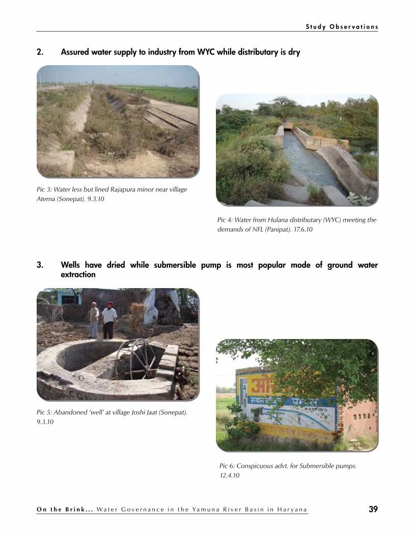
39O n t h e B r i n k . . . W a t e r G o v e r n a n c e i n t h e Ya m u n a R i v e r B a s i n i n H a r y a n a
2. Assured water supply to industry from WYC while distributary is dry
Pic 3: Water less but lined Rajapura minor near village Aterna (Sonepat). 9.3.10
Pic 4: Water from Hulana distributary (WYC) meeting the demands of NFL (Panipat). 17.6.10
3. Wells have dried while submersible pump is most popular mode of ground water extraction
Pic 5: Abandoned ‘well’ at village Joshi Jaat (Sonepat). 9.3.10
Pic 6: Conspicuous advt. for Submersible pumps. 12.4.10
S t u d y O b s e r v a t i o n s

40 O n t h e B r i n k . . . W a t e r G o v e r n a n c e i n t h e Ya m u n a R i v e r B a s i n i n H a r y a n a
4. Waste water is conspicuous both in urban and rural areas
Pic 7: Drain in Panipat. 12.4.10
Pic 8: Polluted state of village pond (Khewara). 27.4.10
Pic 9: Waste water from Gannaur town (Sonepat) accumulated along the railway track. Trees have dried as a result. 17.6.10
Pic 10: Waste water from Samalkha town (Panipat) standing along the railway track behind Nestle Factory. 17.6.10
C H A P T E R 5

41O n t h e B r i n k . . . W a t e r G o v e r n a n c e i n t h e Ya m u n a R i v e r B a s i n i n H a r y a n a
5. Functioning of STPs leave a lot to desire
Pic 11: Poor quality Effluent from 10 MLD STP at Panipat. 12.4.10
Pic 12 : The polluted village pond at the Binjhol village spoiled from the effluents from the 10 MLD STP at Panipat. Villagers had to go to Court to restrain the PHED in the matter.
Pic 13: Hardly any effluent from 35 MLD STP (Panipat) is entering the highly polluted Panipat Drain. (28.4.10)
Pic 14: Idle 35 MLD STP at Panipat. 29.4.10
Pic 15: PCRI at BHEL, Hardwar has been reporting on a monthly basis about the water quality of effluent at both the 10 MLD and 35 MLD STP at Panipat. But the reports do not seem to be a true reflection of the actual water quality at the STPs.
Pic 16: Treated effluent from 30 MLD STP at Sonepat is falling into the polluted waters of Drain no 6. (16.6.10)
S t u d y O b s e r v a t i o n s

42 O n t h e B r i n k . . . W a t e r G o v e r n a n c e i n t h e Ya m u n a R i v e r B a s i n i n H a r y a n a
6. Drains on WYC meant to carry either extra canal water or flood/storm water is predominantly carrying only waste water to the river
Pic 17: Munak Escape (Drain No 2) at its origin (WYC). 11.3.10
Pic 18: Panipat drain (left) meeting Munak Escape (Drain no 2) u/s of Shimla Gujran village. (Panipat). 29.4.10
Pic 19: Munak Escape (Drain No 2) at its end feeding Panipat’s waste waters to the river Yamuna. (11.3.10)
Pic 20: Drain no 6 (foreground) carries waste water to the river alongside Drain no 8 that supplies drinking water from WYC to the WTP at Wazirabad (Delhi). 16.6.10
C H A P T E R 5
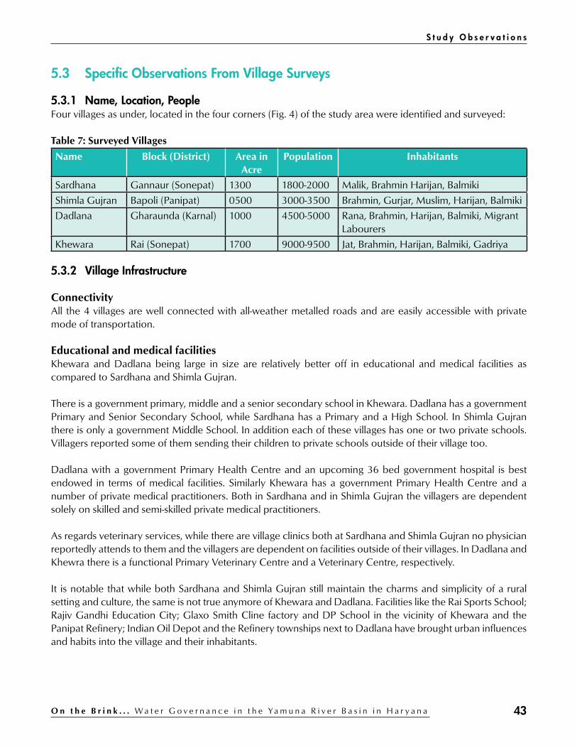
43O n t h e B r i n k . . . W a t e r G o v e r n a n c e i n t h e Ya m u n a R i v e r B a s i n i n H a r y a n a
5.3 Specific Observations From Village Surveys
5.3.1 Name, Location, PeopleFour villages as under, located in the four corners (Fig. 4) of the study area were identified and surveyed:
Table 7: Surveyed Villages
Name Block (District) Area in Acre
Population Inhabitants
Sardhana Gannaur (Sonepat) 1300 1800-2000 Malik, Brahmin Harijan, Balmiki
Shimla Gujran Bapoli (Panipat) 0500 3000-3500 Brahmin, Gurjar, Muslim, Harijan, Balmiki
Dadlana Gharaunda (Karnal) 1000 4500-5000 Rana, Brahmin, Harijan, Balmiki, Migrant Labourers
Khewara Rai (Sonepat) 1700 9000-9500 Jat, Brahmin, Harijan, Balmiki, Gadriya
5.3.2 Village Infrastructure
ConnectivityAll the 4 villages are well connected with all-weather metalled roads and are easily accessible with private mode of transportation.
Educational and medical facilitiesKhewara and Dadlana being large in size are relatively better off in educational and medical facilities as compared to Sardhana and Shimla Gujran.
There is a government primary, middle and a senior secondary school in Khewara. Dadlana has a government Primary and Senior Secondary School, while Sardhana has a Primary and a High School. In Shimla Gujran there is only a government Middle School. In addition each of these villages has one or two private schools. Villagers reported some of them sending their children to private schools outside of their village too.
Dadlana with a government Primary Health Centre and an upcoming 36 bed government hospital is best endowed in terms of medical facilities. Similarly Khewara has a government Primary Health Centre and a number of private medical practitioners. Both in Sardhana and in Shimla Gujran the villagers are dependent solely on skilled and semi-skilled private medical practitioners.
As regards veterinary services, while there are village clinics both at Sardhana and Shimla Gujran no physician reportedly attends to them and the villagers are dependent on facilities outside of their villages. In Dadlana and Khewra there is a functional Primary Veterinary Centre and a Veterinary Centre, respectively.
It is notable that while both Sardhana and Shimla Gujran still maintain the charms and simplicity of a rural setting and culture, the same is not true anymore of Khewara and Dadlana. Facilities like the Rai Sports School; Rajiv Gandhi Education City; Glaxo Smith Cline factory and DP School in the vicinity of Khewara and the Panipat Refinery; Indian Oil Depot and the Refinery townships next to Dadlana have brought urban influences and habits into the village and their inhabitants.
S t u d y O b s e r v a t i o n s

44 O n t h e B r i n k . . . W a t e r G o v e r n a n c e i n t h e Ya m u n a R i v e r B a s i n i n H a r y a n a
5.3.3 Village Use of Water
A. IrrigationThree of the surveyed villages namely Sardhana, Dadlana and Khewara possess canal (WYC system) based irrigation infrastructure, while the fourth village viz., Shimla Gujran, despite lying on either side of the Munak Escape (Drain no. 2) has no such facility and is dependent entirely on the use of ground water for irrigation.
Sardhana villageSituated next to the Delhi Parallel Branch of the WYC at the Khubru Head, Sardhana stands out over the other two villages in terms of utilisation of canal water. About 700 acre (out of the 1300 acre irrigable land) is being irrigated with canal water. The village has on its south two canal head based outlets of Rajapura distributary and Bajana minor and lie at the tail of Israna and Hulana distributaries of WYC. Due to technical reasons outlet from Rajapura (installed in 2008) is irrigating just 10 -15 acre of land against the capacity of 45 acres. Sardhana shares in mutual arrangement the 6 cusec water released from the Bajana minor with nearby villages of Touydi and Pugthala. This irrigates about 600 acres of land in the village. The tail of Israna (command of 300 acre) and Hulana (command of 35 acres) have reportedly not received canal water for years.
Landa rajwaha (water course) from the Israna distributary (now part of Dhindar minor) is reported to have no water supply due to uneven surface level of the course. Whereas the lined water course of the Hulana distributary is defunct just like the Water User Association (WUA) formed in the village to manage it.
It is thus little wonder that a village located next to the WYC and possessing good irrigation infrastructure is still heavily dependent on ground water (tube-wells and submersible pumps) to meet its irrigation needs.
Dadlana villageDadlana village lying on the Munak Escape (Drain No 2) has provision of canal water supply from Begumpur minor which off takes from the Bajida Jata Distributary. The outlet on the Begumpur minor is shared with the adjoining village of Begumpur. The water course is lined up to the boundary of Begumpur village and is unlined in the area of Dadlana.
Villagers reported that the canal water is enough to irrigate not more than 15 acres, and with the supply being irregular and insufficient, has compelled the farmers to make alternate arrangements (Tube wells and submersible pumps) to source ground water for irrigation purposes.
Regular flow in the nearby Munak Escape had greatly facilitated the ground water recharge and thus the fall in ground water from irrigation use was by and large getting compensated. But with the closure of Munak escape for the last two years the water table in the village has started to show a declining trend.
Khewara village1L (left) Rajapura minor passes next to the Khewara village. The village has been provided four (4) out-lets on the Rajpura minor, which is meant to irrigate 300 acres of land in the village area. Villagers reported irrigating no more than 80 acres of land from these outlets. They have a mutually formed warabandi for the area irrigated although the Irrigation department reportedly collects charges (Ugahi) for only 35 acres (official extent of Warabandi in the village).
C H A P T E R 5

45O n t h e B r i n k . . . W a t e r G o v e r n a n c e i n t h e Ya m u n a R i v e r B a s i n i n H a r y a n a
The survey reports the following reasons for the poor utilisation of canal water facilities in the village:a) Large part of the land adjoining the Minor belongs to the Panchayat and hence is not part of any individual
chak. b) As the village lies close to the National Highway (NH 1), part of its Panchayat land has been either
acquired by the government (beginning with land for the Sports School at Rai) or purchased by the private entrepreneurs and the price of the land in the village has resultantly gone up many times.
c) The Minor has a total length of 120 RD but is currently maintained up to 94 RD. The Khewara village falls at 71 RD and the Motilal Nehru Sports School at Rai is situated at 83 RD. Therefore there is water in the canal at Khewara only because it falls u/s of the Sports School for which there is a definite supply from time to time of water through the minor.
d) The 1L Rajapura Minor was constructed in 1960s, after the land consolidation (Chak bandi) process had already been completed. No water courses were then laid by the Irrigation Department. So now if a water course has to be laid then it shall pass through private land, which if utilised for the purpose would require to be paid for by the water users. Since the land is now expensive and the canal water supply is uncertain, the potential water users find it cost effective to make do with their private tube-well rather than meet the expenses of laying a water course.
e) The Motilal Nehru Sports School at Rai is supplied canal water on a priority basis.
Informal consultation with the officials of the irrigation department reveal that on account of fast changing land use scenario where most land along the NH1 (including that of the Khewara village) would soon get converted either for commercial, residential or service sector use, the department is considering to de-command the area and then the water in the Minor would be available only for the use of the Sports School at Rai.
Shimla Gujran-Shimla Gujran has no canal based supply and it depends entirely on the ground water extraction for meeting its irrigation needs.
Just like in the case of the Dadlana village, Shimla Gujran too, despite lying on the banks of the Munak Escape (Drain no. 2) is now facing severe fall in its water table as there is no ground water recharge from the water flowing earlier in the Munak Escape. More over since Shimla Gujran lies downstream of the point where the Panipat drain disgorges its highly polluted water into the Munak Escape (pic 18), there is always polluted water in the drain, which is finding its way to the underground and polluting the village’s ground water.
B. Drinking waterAccording to the survey, wells and hand pumps in the villages are now things of the past, except in the Sardhana village where a lone hand pump (pic 24) alongside the WYC is meeting the most drinking water needs of the village.
Table 8: Water sources for domestic use
Village No. of Jalghar
Panchayat TW
Panchayat Hand pump
Private TW
Water Works
Pond Wells
Sardhana 01 04 15-20 15-20 01 04 02
Dadlana 02 100 500 25 - 02 03
Khewara 01 200 20 300 - 04 02
Shimla Gujran 02 25 00 30 - 00 00(Source: Field Survey, 2010)
S t u d y O b s e r v a t i o n s

46 O n t h e B r i n k . . . W a t e r G o v e r n a n c e i n t h e Ya m u n a R i v e r B a s i n i n H a r y a n a
It is either the government installed Jalghar, or private as well as panchayat installed tube wells and submersible pumps that are meeting the drinking water needs of the villagers in all the four (4) surveyed villages. There is also a government scheme to install water works, locally called as a ‘diggi’, to supply drinking water sourced from surface supply like a canal. It is only in the Sardhana village where a diggi was constructed way back in 1987 (pic 25), but which is reportedly still to become operational.
Jal GharAll the 4 surveyed villages have Jalghars (deep and high capacity tube wells) which have been installed and run by the PHED to supply drinking water to the villagers. It is planned to hand over the running and maintenance of the Jalghar to the local Panchayats but the Panchayats seem reluctant to take up the responsibility.
It has been observed that the Jalghar scheme while meeting a part of the essential drinking water needs of the villagers is beset with a number of problems:a) Jalghars run only when there is power supply, which is erratic and uncertain.b) Resultantly the Jalghar operator is unable to maintain any fixed timings and often the Jalghar, running for
the entire period there is power supply, over supplies the water, which then goes waste.c) Pipelines laid to connect the household with the Jalghar are reportedly of inferior quality and thus often
leak resulting in wastage of water. d) Jalghar do not cover the entire village. e) Villagers often resort to unaccounted connections from the Jalghar pipe-line, thus avoiding connection
charges of Rs 500 (Rs. 250 for Scheduled Caste/ Backward Classes under Indira Payjal Yojna) payable to the PHED.
f) Cost of water supplied per connection which is Rs. 20 per connection per month (Rs. 10 for Scheduled Caste/ Backward Classes under Indira Payjal Yojna ) is reportedly not paid by the villagers.
Panchayat/Private tube-wells for water supplyAll the surveyed villages reported a large number of panchayat installed as well as private (by the rich in the village) tube wells (including submersible pumps) in the village to meet the HH drinking water needs.
It was seen and reported that most private/panchayat installed tube-wells in all the surveyed villages except Dadlana use kundi (unmetered and illegal power connection) system to run their tube - wells.
Abuse of the systemIt is reported and seen during the survey that drinking water from both the Panchayati and private tube well/submersible pumps is being used for non drinking purposes like bathing of cattle, washing of homes, streets, vehicles etc. This results in rampant wastage of water which in turn stands as waste water on village streets or over flows and floods the village ponds (most evident in the Khewara village).
EquityIt is reported and seen during the survey that while on one hand the rich and the dominant households in the villages have water to waste, the house holds belonging to the weaker sections struggle to get enough.
This is because that while the Jalghar supplies are erratic, uncertain and do not cover all the households, they (weaker section households) cannot afford to have personal tube wells/submersible connections, and the same when installed by the panchayat (even which are selectively provided in pockets of the powerful or the influential in the village) soon get monopolised by few individuals and thus are not easily accessible to the
C H A P T E R 5

47O n t h e B r i n k . . . W a t e r G o v e r n a n c e i n t h e Ya m u n a R i v e r B a s i n i n H a r y a n a
members of the weaker sections. The government schemes like the Indira Payjal Yojana meant exclusively for the weaker sections has little benefitted them, except to provide them with a 200 litre water tank. But without water what use is the water tank?
C. Village ponds and wells The traditional water sources like ponds and wells have either been encroached upon or lie abandoned in all the surveyed villages.
The village ponds (all the surveyed villages except Shimla Gujran has one or more) are no longer used for either drinking or irrigation purposes. The village ponds act as receiver of waste water from the village or collection of rain water during the monsoon season and serve primarily as bathing sites for the village cattle.
Even the four (4) ponds dug in the Sardhana village under the Hariyali scheme for rain water harvesting were reportedly under dug and hence readily flood whenever there is heavy rainfall, compelling the villagers to pump out the water from them into nearby drain.
In the Dadlana village a hospital is being constructed over reportedly reclaimed 4 acre of the 6 acre pond area and the original pond has been converted from being a natural one into an artificial one (pic 23) where water is now required to be filled from time to time from the nearby Jalghar after the standing and often stinking water from the pond has been drained out into the nearby Munak Escape (Drain No 2).
It is a strange irony that located next to the Munak Escape (Drain No. 2) the Shimla Gujran villagers had never felt the need of a pond. And now after the closure of the escape they are left with only stinking waste water of Panipat city (drained into Munak Escape by the Panipat drain) in it with all the concomitant risks to the health of humans and cattle of the village.
The ponds in Khewara village get regularly flooded with the village’s waste water more due to careless and blatant misuse of drinking water supplied from the Jalghar or extracted by the private tubewell / submersible pump connections.
Wells in all the four surveyed villages have either been abandoned or filled, although the well (pic 26) in the Sardhana village could easily be revived (though seemingly has no stake holder for it). Dadlana and Shimla Gujran have done away with their wells whereas the same in Khewara have run dry due to the falling water table.
S t u d y O b s e r v a t i o n s

48 O n t h e B r i n k . . . W a t e r G o v e r n a n c e i n t h e Ya m u n a R i v e r B a s i n i n H a r y a n a
Village Survey - General ObservationsGrowing of paddy in the study area is primarily as a cash crop since eating of rice is not a part of the z
staple diet of the region. Farmers are largely unaware of the government schemes like UGPL (Under Ground Pipe Line) and z
Laser Levelling and hence have benefitted little from them. Water thefts from canal/distributaries/minors are quite common. z
Canal water does not reach the tail ends of canal distributaries and minors. z
Farmers being not assured of canal water supplies are steadily reducing their dependence on the same z
and resorting to ground water extraction for meeting their irrigation needs. The number of power run ground water extraction pumps (Private, panchayat, and departmental tube z
wells, submersible pumps) has gone up manifold in the last one and a half decade. Departmental regulations such as ban on growing of Sathi Dhan and burning of straw etc are not z
entirely effective nor enough to conserve resources like soil and ground water. There are no community evolved/framed rules & regulations regarding judicious use and conservation z
of resources like soil and ground water, nor is there any initiative for the same despite there being a widespread acknowledgement of a need thereof. Villagers / Panchayats / concerned departments lack plans to reduce consumption of fresh water z
and / or recycling of used water.
Pic 21: Meeting in Khewara village. 27.4.10
Pic 22: Outlet in Rajapura minor at Khewara village. 9.3.10
C H A P T E R 5

49O n t h e B r i n k . . . W a t e r G o v e r n a n c e i n t h e Ya m u n a R i v e r B a s i n i n H a r y a n a
Pic 23: Hospital (36 bed) under construction in part of the village pond land (Dadlana village). 12.4.10
Pic 24: Lone hand pump along the WYC that meets the drinking Water needs of Sardana Village (Sonepat). 16.6.10
Pic 25: Water works (diggi) at village Sardana (Sonepat).Defunct since 1987, but is often repaired. 16.6.10
Pic 26: Well at Sardhana village. 16.6.10
S t u d y O b s e r v a t i o n s

50 O n t h e B r i n k . . . W a t e r G o v e r n a n c e i n t h e Ya m u n a R i v e r B a s i n i n H a r y a n a
Study Findings
6.1 There is not Enough Water in the WYC System
According to a study (Hellegers, 2007), the available supply of water in the irrigation system is well below potential demand and water is rationed in proportion to irrigable area.
The above fact is corroborated by supply in rotation of water from the WYC canal system for irrigation purposes to branches on a rotation of 8 days. According to this rotation system, which is fixed on six monthly basis (for kharif and rabi season) the water for irrigation flows in these branch canals, as per availability in ‘full’ flow or ‘nil’ flow basis. At the Khubru head where the water is supplied to four different branch canals (JLN, Butana, Bhalaut and Sunder) it will be only after 3 weeks to a month that the turn of a branch canal would come.
For example during the 2010 Kharif season around 6000 cusec is available for 4-groups rotational program from April – October. (letter dated 27 April 2010, from Engineer-in-Chief, Irrigation Department, Haryana). It is notable that the said letter from the E-in-C, Haryana specifically requests the Director, Agriculture department, to “publicise the sowing of less water requiring crops in the state during the Rabi season, please”.
The scarcity of water for irrigation is also indicated by the following table which shows that at least in two districts (Karnal and Panipat) in the study area the ground water irrigation (tube wells) far exceeds that from the canal while in the other (Sonepat) canal irrigation just about equals that from the ground (tube wells):
Table 9: Net area under irrigation (‘000 ha)
District Canal Tanks Wells Tube Wells Other source
Total
Karnal 75 - - 123 - 198
Panipat 28 - - 68 - 96
Sonepat 85 - - 70 - 155(Source: Director of Land Records, 2007-08)
chapter 6
The field work in the surveyed villages endorses the fact that there is not enough water in the WYC and resultantly the situation is as under:f) The Water User Associations (WUA) formed in villages Sardhana (Sonepat) and Khewara (Sonepat)
are non functional for want of any security of water supply to the consumers/members of the WUA.g) At Khewara the farmers avoid becoming part of warabandi as they might end up paying for water that
they may not actually receive through the Rajapura minor h) At Joshi Jaat village there has not been any water for several years at the end of the Rajapura
distributary despite the distributary having been lined under the WB funded ‘Haryana Water Resources Consolidation Project’.

51O n t h e B r i n k . . . W a t e r G o v e r n a n c e i n t h e Ya m u n a R i v e r B a s i n i n H a r y a n a
6.2 Demands on the Waters of the WYC System are on an Increase
A comparative look (Annexure 2) at water allocations made from the WYC between 2001 and 2010 reveals that demands on the canal water are not just increasing but also diversifying.
If we compare the essential allocations (which must be supplied continuously no matter which group is getting the supplies in the rotation) we find that more and more claimants on the canal water are emerging. And since the quantum of water in the canal is not expendable endlessly despite an increase of 4000 cusec in the barrage’s capacity to hold water after the barrage at Tajewala was replaced by the one upstream at Hathnikund, an increase in the quantum and kind of essential allocations can only be at the cost of supplies otherwise meant for irrigation purposes:
Table 10: Additional requirement at Munak in Cusec
S. No.
Claimant 2001 2010 Remarks
1. HTP (Haiderpur Treatment Plant), Delhi
523.00 485.00 Drinking water
2. PTP (Panipat Thermal Plant) 80.00 90.00 Industrial
3. NFL (National Fertiliser Limited), Panipat
40.00 45.00 Industrial
4. GWS (Gurgaon Water Supply) 70.00 138.00 Drinking water
5. P.N.C.P (Panipat Naptha Cracker Plant)
0 45.00 Industrial/Drinking water
6. Addn. Losses 25.00 25.00
Total 738.00 828.00
7. Refinery Channel 30.00 35.00 Industrial/Drinking water
8. For Minimum flow on Yamuna below Wazirabad (For Agra/Gurgaon Canal)
240.00 165.00 Irrigation
9. Delhi Jal Board 0 92.00 Drinking water (Delhi)
10. Transit Losses from Tajewala to Munak & NBK+SYL*
- 516.00
11. C.L.C. (Carrier Lined Channel) 0 400.00 Drinking water (Delhi)
TOTAL 1008 cusec
2036 cusec
(Source: WAPCOS, 2003 and Irrigation Department, 2010)
* This figure is not comparable as the ‘transit losses’ as enumerated and considered for the 2010 season were not considered
as part of ‘additional requirement’ at Munak during the 2001 season.
Clearly water from canal is increasingly being diverted to meet either the drinking water needs or the industrial needs. It is notable that just one claimant (S.No.8) in the table above and which is meant for Agra/Gurgaon Canal through river Yamuna to irrigate areas in south east Haryana has actually seen a decrease in allocation from 240 cusec to 165 cusec.
S t u d y F i n d i n g s

52 O n t h e B r i n k . . . W a t e r G o v e r n a n c e i n t h e Ya m u n a R i v e r B a s i n i n H a r y a n a
The under construction NCR Channel u/s of Kakroi Head on the Delhi branch of WYC is the latest and most clear example of the manner in which the canal waters are being gradually but surely diverted to meet not just public drinking water needs but also private player’s needs for real estate and industrial projects.
Such diversion of canal water from WYC for non irrigation and non drinking purposes is prima facie violative of the 1994 MOU signed between the riparian states of river Yamuna according to which allocation of the utilizable water resources of river Yamuna is meant for “ irrigation and consumptive drinking water requirements of the basin states”.
6.3 There is Little Lean-season Flow in the River System
The compromised state of the river as a result of almost total abstraction of its water into the WYC and the EYC at Hathnikund Barrage is a classic example of the tragedy of ‘commons’.
The 1376 km long river Yamuna which was not only perennial but is counted amongst the holiest of rivers in the country is today bereft of any flow of its own for almost 650 km of its length from d/s of Hathnikund barrage till Bhareh (Etawah) in the lean season months of March – June. The reason for this sad state of affairs is not far to seek.
At the time of the formation of Haryana state in 1966 from the erstwhile undivided Punjab, it was an agreement between the Punjab and Uttar Pradesh governments made on 12th March 1954 regarding distribution of supplies at Tajewala head works between Western Jamuna (Yamuna) Canal and Eastern Jamuna (Yamuna) Canal that determined the distribution of the Yamuna waters in the event of the river discharge being less than the total indent of the two canals. (Annexure 8).
Later on 12th May 1994, an MOU was signed between the five (Uttar Pradesh, Himachal Pradesh, Haryana, NCT of Delhi and Rajasthan) riparian states of the river regarding allocation of surface flow of Yamuna (Annexure 1). Upper Yamuna River Board (UYRB) has been created in the CWC (Central Water Commission) to oversee the implementation of the 1994 MOU.
These agreements which have been based primarily (with a lip service to ecological flows in the river) on the riparian state’s requirements of irrigation and consumptive drinking water requirements have progressively robbed the river of its natural flow to an extent that now downstream of Hathnikund barrage only a symbolic flow of 160 cusec is reportedly maintained (to meet the needs of flora and fauna in the river) by Haryana as a minimum flow in the river. It is seen that this limited discharge in the river d/s of Hathnikund barrage is not even enough to reach Kalanaur (Yamuna Nagar) some 35 km downstream of Hathnikund what to talk of meeting the water needs of the flora and fauna in the entire river.
Intervention of the Supreme CourtThe Supreme Court of India in Cdr Sureshwar D Sinha Vs Union of India (W.P. (C ) 537 of 1992) ordered on 14th May 1999 that “a minimum flow of 10 cumec (353 cusec) must be allowed to flow throughout the river
C H A P T E R 6

53O n t h e B r i n k . . . W a t e r G o v e r n a n c e i n t h e Ya m u n a R i v e r B a s i n i n H a r y a n a
Yamuna” (Dutta, 2009). A formula was also decided by the Court about the share of riparian states in the proposed 10 cumec of minimum flow:
Table 11: Share of minimum flow
State Percentage
Haryana 57
UP 28.7
NCT of Delhi 4.6
Rajasthan 5.2
HP 4.8(Source: Dutta, 2009)
A contempt notice in the case was also issued on 21st July 1999 by the Court, to the Chief Secretary of Haryana, requiring him to show cause why action of contempt be not taken against him.
And yet the flow in the river d/s of Tajewala/Hathnikund barrage/s has progressively declined as shown below:
Figure 5: Flow in River Yamuna (Source: Panwar 2009)
Closure of Munak EscapeMunak escape or Drain No. 2 (Fig. 2) originates (pic 17) u/s of Munak Head on main branch of WYC. Formally constructed first in 1974 (although as per XEN, CADA, Panipat it has been in existence since late 19th century). With a capacity of 2000 cusec it conveyed around 500 cusec of water to the river till late 2008 to meet the drinking water needs of Delhi at its Wazirabad WTP (Water Treatment Plant). This flow ensured that there was always some flow in the river between Panipat and NCT of Delhi. It being unlined also ensured that there was a regular recharge of ground water from it benefitting at least 10 villages located on or close to it.
Then on 25th December 2008 a telephonic message from XEN, Sonepat revised the flow through Munak Escape and thus changed everything.
S t u d y F i n d i n g s

54 O n t h e B r i n k . . . W a t e r G o v e r n a n c e i n t h e Ya m u n a R i v e r B a s i n i n H a r y a n a
“Requirement at head Parallel Delhi Branch may be considered as under with effect from 4 a.m. on 26/12/08:
Table 12: Water allocation at Munak Head of WYC
User Allocation (Cusec)
Plants 637
GWS (Gurgaon Water Supply) 120
NTP (Nangloi Treatment Plant) 60
N/G (Najafgarh drain) 240
Downstream Khubru C.L.C.(DJB) 400
SDR (SUNDAR BRANCH) 12
BLT (BHALAUT BRANCH) 1498
Total 2967Munak Escape – NIL” (Source: RTI response dated 5/7/10 from XEN, Sonepat).
A discussion on the sudden closure of the Munak Escape by the Irrigation department of Haryana held at a one day workshop on 26 July 2010 at Panipat revealed that:a) Since Munak Escape was not an irrigation canal so the Irrigation department was within its right to close it
as it thought fit.b) The irrigation department was losing about 250 cusec to seepage losses as only 250 cusec of the released
500 cusec actually reached Delhi when supplied through the Munak Escape and the river.c) The irrigation department was now supplying the same 250 cusec to Delhi through the lined Drain No 8
(in place of Munak Escape / Drain no 2) and utilising the ‘saved’ 250 cusec of canal water elsewhere in the state. (Unconfirmed claim).
Prima facie the arguments put forth by the XEN, CADA at Panipat might seem well placed, but it is symptomatic of the rigid departmental compartments in which the bureaucracy tends to operate at the cost of many other valid considerations. The questions that the sudden closure of Munak Escape / Drain no. 2, beg answers to are:1. What about the needs of the people in the villages located alongside the Munak Escape whose social life
revolved around water in the drain. Did they not deserve even a reasonable notice to come to terms with the ceasing of flow in the drain?
2. Effluent from the 35 MLD STP that fell into the Panipat drain and finally reached the Munak Escape (pic 18) was diluted due to flow in the Munak Escape. This dilution role of the Munak Escape was removed and as a result now it is only the heavily polluted waters in the Panipat drain which is reaching and creating serious health hazards to people and cattle in villages like Shimla Gujran that are located downstream of the point where the Panipat drain meets the Munak Escape.
3. What the irrigation department considers as seepage ‘losses’ was actually ground water ‘recharge’ that was taking place due to the water flowing in the unlined drain and later in the river?
4. What about the river and all the other associated beneficiaries who were dependent on the water flowing in the river fed by the Munak Escape?
5. It is understood that till the closure of the Munak Escape, there was water always in the river in at least the Sonepat stretch of the river down to Delhi. Now all that is dry (pic 1).
C H A P T E R 6

55O n t h e B r i n k . . . W a t e r G o v e r n a n c e i n t h e Ya m u n a R i v e r B a s i n i n H a r y a n a
6.4 Increasing Demands on Water Resources
It is seen that the state of Haryana is slowly but steadily transforming itself from being predominantly an agrarian economy into a much diverse economy where industry, manufacturing and service sector plays an increasingly important role. This entails varied and increasing demands on all the available water sources in the state.
The structural composition of state economy has witnessed significant changes since the formation of Haryana State. Agriculture sector still continues to occupy a significant position in the state economy, although, the share of this sector in the Gross State Domestic Product is continuously declining. The composition of Gross State Domestic Product at constant (1999-2000) prices reveals that the share of Primary Sector which includes Agriculture and Allied Sectors has declined from 32.0 percent during 1999-2000 to 20.5 percent during 2007-08. The composition of Gross State Domestic Product reveals that the share of Primary Sector is continuously declining whereas the share of Secondary as well as Tertiary Sector is continuously increasing. It shows that the State economy is shifting from Agriculture to Manufacturing and Services Sectors (Anonymous, State of Economy 2008-09)
Table 13: Composition of Gross State Domestic Product by Broad Sectors
Year At Current Prices At Constant (1999-2000) Prices
Primary (%)
Secondary (%)
Tertiary (%)
Primary (%)
Secondary (%)
Tertiary (%)
1999-00 32.0 28.5 39.5 32.0 28.5 39.5
2000-01 30.5 27.7 41.8 30.7 27.6 41.7
2001-02 27.7 28.9 43.4 28.5 28.1 43.4
2002-03 25.5 30.3 44.2 26.3 28.8 44.9
2003.04 25.0 30.6 44.4 25.8 29.2 45.0
2004-05 23.1 31.8 45.1 24.5 30.0 45.5
2005-06 (P) 21.0 32.1 46.9 22.2 30.0 47.8
2006-07 (P) 21.9 31.2 46.9 22.2 29.5 48.3
2007-08 (Q) 21.7 31.0 47.3 20.5 29.7 49.8(Source: Economic & Statistical Analysis Department, Haryana)
P= Provisional Estimates Q=Quick Estimates
Clearly a drain like Munak Escape is not just an escape or a drain but has important socio economic and ecological dimensions to it, which cannot and should not be ignored before critical decisions relating to them are taken.
S t u d y F i n d i n g s

56 O n t h e B r i n k . . . W a t e r G o v e r n a n c e i n t h e Ya m u n a R i v e r B a s i n i n H a r y a n a
Clearly the contribution of the primary sector (agriculture and allied) in the state in just a decade been reduced below the secondary sector (manufacturing activities) and to around 50% of the Tertiary sector (service related activities). And what is notable is that this decline is consistent over the years.
This change cannot be without its impact on water resources and supplies to meet the growing demands of both the secondary and tertiary sectors. Often the water supplies to the latter sectors is at the cost of the former, both sourced from surface (river and canal) as well as the under ground.
It is important that the planners do not fail to notice this change and impact and account for it in their planning if the food and water security in the state is to be ensured.
Table 14: Water needs of few select industries and facilities
Name of the Agency Amount of water used Source of water
Drinking Purpose Other Purpose
Indian Oil Corporation Limited, Panipat
1.776 MLD. 4.812 MLD Haryana Irrigation Department. (WYC)
National Fertilizers Limited, Panipat
8866.407 million ltrs. During 2009-10.
Hulana distributory of Yamuna Canal. (WYC)
Motilal Nehru School of Sports, Rai, Sonepat
.8 MLD. Ground water and stored water of canal base. (Rajapura Distributary)
Panipat Thermal Power Plant, Panipat
90 cusec (cubic feet per second) as per 2010 allocations
Haryana Irrigation Department. (WYC)
(Source: RTI responses, 2010)
A perusal of the above table indicates that in the study area canal water supplied by the Irrigation Department in the WYC command (including its distributary like Rajapura and Hulana) is meeting the drinking and other needs of industries like IOC refinery, NFL and PTP at Panipat but also service facilities like the Motilal Nehru School of Sports at Rai (Sonepat).
It is also seen that in addition to the water from the canal system, the ground water is a major source of meeting various demands on water in the study area.
C H A P T E R 6

57O n t h e B r i n k . . . W a t e r G o v e r n a n c e i n t h e Ya m u n a R i v e r B a s i n i n H a r y a n a
Table 15: Highly (>300 KLD) water consuming industries in Sonepat
Name and Address of the Unit Qty. of water in KLD
Water Supply Source
M/s Atlas Cycles (Haryana) Pvt. Ltd. Atlas Road, Sonepat
300 Own tubewell
M/s Ch. Devi Lal Co-op Sugar Mills Ltd., Vill. Ahulana, Tehsil Gohana, Sonepat
650 Own tubewell
M/s Flora Dyeing House (Pvt Ltd. 393, HSIDC, Barhi, Sonepat
450 Own tubewell
M/s Glaxo SmithKline Consumer Healthcare Products Ltd.
Own tubewell
Sonepat Meerut Road, Vill. Khewara, Sonepat.
450 Own tubewell
M/s Kohinoor Foods Ltd.G.T. Road, Murthal Sonepat
410 Own tubewell
M/s Milton Cycle Industries Ltd.Indl. Area, Sonepat
350 Own tubewell
M/s Oriental DyersPlot No. 387-88, HSIDC, Barhi, Sonepat
650 Own tubewell + HSIIDC water supply
M/s Riba Textiles Ltd.,Vill. Chidana, Gohana
360 Own tubewell
M/s SKOL Breweries Ltd.G.T. Road, Muthal
750 Own tubewell
M/s Sonu Enterprises358, HSIDC, Indl. Area, Sonepat
350 Own tubewell + HSIIDC water supply
M/s Vardhman Gar-Tex420, HSIDC, Barhi, Sonepat
475 Own tubewell + HSIIDC water supply
(Source: Haryana State Pollution Control Board, Sonepat, 2010)
Assessing and planning on meeting the domestic water demands of a major city like Panipat is a good indicator of the changing water situation in the study area.
Table 16: Zone wise demand and supply of water in Panipat City
Wards Area (sq. km.)
Population No. of Tube wells
Existing Supply @ .35
mld per tubewell
Existing demand
2006 (mld) @ 180 lpcd
Short fall (mld)2001 2006
6,7,8,9 3.336 29069 34883 11 3.85 6.28 2.43
5,17, 18,19 2.38 30393 36472 10 3.50 6.56 3.06
10,11, 12,13 1.82 40914 49097 9 3.15 8.84 5.69
15,16,21 1.817 21742 26090 2 0.70 4.70 4.00
S t u d y F i n d i n g s

58 O n t h e B r i n k . . . W a t e r G o v e r n a n c e i n t h e Ya m u n a R i v e r B a s i n i n H a r y a n a
Wards Area (sq. km.)
Population No. of Tube wells
Existing Supply @ .35
mld per tubewell
Existing demand
2006 (mld) @ 180 lpcd
Short fall (mld)2001 2006
20, 22, 23 2.774 28783 34540 5 1.75 6.22 4.47
1,2,3 3.026 37190 44628 4 1.40 8.03 6.63
4,25,26, 27 4.001 35374 42449 19 6.65 7.64 0.99
24,28,29,30,31,32 3.662 45658 54790 3 1.05 9.86 8.81
Total 22.816 271124 324955 63 22.05 58.13 36.08(Source: PHED, Panipat Division)
C H A P T E R 6
Similarly the state of water harvest and villager’s impression of the status of ground water in their villages points to an increasing water stress in the study area.
Table 17: Water harvest and Water table in the studied villages
Villages Personal Hand pumps
Panchayati Hand pumps
Personal Submersible
Panchayati Submersible
Jalghar Water Table (meter)
Sardhana 30 25 10 10 01 09-18
Dadlana 50 500 25 100 02 24-27
S h i m l a Gujran
0 0 20 25 02 24-27
Khewara 20 30 400 200 01 27-30
Rajlu Garhi 10 00 150 08 07 24-27
Joshi Jat 0 20 70 10 01 24-27(Source: Field survey 2010)
It is acknowledged that Haryana is a water scarce state. Following excerpts from the minutes of the conference of DC/SP held under the chairmanship of Hon’ble CM of Haryana on 24th February, 2010 is illustrative of the water situation where theft of water is seen as an issue serious enough to draw the CM’s attention:
“FC & PS Irrigation expressed concern over the probability of increase in the water theft cases in view of water shortages. He explained the water rotation system being adopted keeping in view the near drought like situation. He requested the police department to cooperate with the irrigation department to prevent water thefts. Hon’ble CM, Haryana laid emphasis on the need for close coordination between DCs, SPs and the officials of the Irrigation Department.”
The Chief Minister of Haryana has recently announced the plans to develop 13 theme cities (Fashion city; Film city; Entertainment city etc) along the upcoming KMP (Kundli Manesar Palwal) express-way that encircles the NCT of Delhi on its west. (Source: Punjab Kesari dated 16 June 2010). It is a moot point as to wherefrom are the water needs of such developmental plans going to be met?

59O n t h e B r i n k . . . W a t e r G o v e r n a n c e i n t h e Ya m u n a R i v e r B a s i n i n H a r y a n a
It is seen that while the water supply from the canal system is regulated by the Irrigation department there is little regulation on the extraction of ground water to meet various needs. As a matter of fact the records point to the fact that extraction of ground water is increasing at a pace that does not augur well for its sustained availability in the future.
Following facts were accessed (pers. comm. Mr. Anil Gupta, CE Coordination, Irrigation Dept.) during personal interviews with senior officials of the Irrigation department at Panchkula:a) State Water Policy is under the state’s consideration since 2007b) There is a proposal for the launch of a State Water Mission on the lines of the National Water Missionc) Conjunctive use of ground water for irrigation purposes along with canal water might require that the
management of ground water becomes the mandate of the irrigation rather than that of the agriculture department in the state.
S t u d y F i n d i n g s
An interesting observation is that while the state has tried to restrict the use of sub- soil water for paddy cultivation by the farmers during the summer months of May and June (ban on sowing of Sathi Dhan) through the enactment of “The Haryana Preservation of Sub Soil Water Act, 2009” (Haryana Act No. 6 of 2009) nothing of this kind has yet been thought necessary to ration and regulate the use of ground water by the non agricultural sectors (Industrial, manufacturing and service) in the state. It is also a fact that it is much more necessary to restrict the use of ground water by the latter as their extraction is on a regular basis, while the farmer’s requirements for agricultural use are largely seasonal.
In this context it may also be useful to note that a Bill to regulate and manage the development of ground water and the matters connected therewith and incidental thereto, has been under consideration in the state since July 2008. The Bill on enactment to be called as “Haryana State Groundwater Management & Regulation Act, 2008” has been found necessary on account of the following grounds:I. The fresh Groundwater resources in Haryana are limited and the rate of utilization in many area exceed the
annual recharge thus cause imbalanceII. There is need to regulate the development and use of groundwater and check saline-fresh interface.III. There is need for enhancing groundwater recharge by utilizing different sources of water (e.g. rainwater,
surplus floodwaters, Canal water during monsoon and treated waste water)IV. There is need to check and control groundwater contamination and pollution.V. There is need to explore, develop and regulate deep aquifersVI. (Need to regulate) commercial selling of ground water VII. Legislation is considered necessary for the optimum development of groundwater potential and protect it
from over-development and pollutionSimilarly a draft State Water Plan (SWP) mandated to be developed as part of the Haryana Water Resources Consolidation Project (IDA-25920) funded by the World Bank (1994-2001) is still to be finalized. The SWP was planned to act as a policy which recognizes the importance of a holistic approach to water resources planning and management.

60 O n t h e B r i n k . . . W a t e r G o v e r n a n c e i n t h e Ya m u n a R i v e r B a s i n i n H a r y a n a
6.5 Water Table is Falling
In the early 1960s, there were only about 100,000 bore wells in India and today the estimates are anywhere between 21 and 26 million (Endersbb, L, 2005). In Haryana alone this number has increased from 25,000 in 1960s to around 700,000 at present (Director of Agriculture, Haryana).
The ability of a user to draw water from deep underground (as deep as 200 – 300 m) through use of submersible pumps has made the user unmindful of the precarious situation with the water table. It is seen in the field that the advertisements of submersible pump companies are the most conspicuous (pic 6).
The result is as under:
Table 18: Statement showing Blockwise historical water table fluctuation between 1979 and 2008 in District Sonepat
S. No.
Block Depth of Water (m) Fluctuation in metresJune 1979-2008June 1979 June 2008
1. Ganaur 3.18 12.93 -9.75
2. Gohana 2.54 5.26 -2.72
3. Kathura 2.60 3.01 -0.41
4. Kharkhoda 3.48 4.14 -0.66
5. Mundlana 1.92 5.10 -3.18
6. Rai 4.47 12.46 -7.99
7. Sonepat 4.17 10.04 -5.87
Average 3.19 7.56 -4.37(Source: Ground Water Cell, Haryana Agriculture Department, July 2008)
Water table situation (June 2010) in Panipat areas is as follows:
Table 19: Water Level & Fluctuation in District Panipat from June 1999 to June 2010
S. No.
Name of Block June-99 (m)
Jun-04 (m)
June-10(m)
Fluc. 99-04 (m)
Fluc. 04-10(m)
Fluc. 99-10(m)
1. Panipat 11.35 18.82 23.24 -7.47 -4.42 -11.89
2. Samalkha 11.49 17.86 22.07 -6.37 -4.21 -10.58
3. Madlauda 6.09 8.7 11.02 -2.61 -2.32 -4.93
4. Israna 5.19 6.82 8.79 -1.63 -1.97 -3.6
5. Bapoli 8.53 12.1 15 -3.57 -2.9 -6.47
Average 8.53 12.86 16.02 -4.33 -3.16 -7.49(Source: Hydrologist, Ground Water Cell, Karnal, 2010)
The above table indicates a progressive decline since 1999 in water table in different blocks of Karnal and Panipat districts. It is notable that the fast urbanizing and industrializing blocks of Panipat and Samalkha in the district have seen the most declines.
C H A P T E R 6
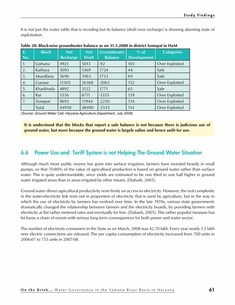
61O n t h e B r i n k . . . W a t e r G o v e r n a n c e i n t h e Ya m u n a R i v e r B a s i n i n H a r y a n a
It is not just the water table that is receding but its balance (draft over recharge) is showing alarming state of exploitation.
Table 20: Block-wise groundwater balance as on 31.3.2008 in district Sonepat in HaM
S. No.
Block Net Recharge
Net Draft
Groundwater Balance
% of Development
Categories
1. Gohana 4921 5013 -92 103 Over Exploited
2. Kathura 3093 1369 1724 44 Safe
3. Mundlana 5696 3963 1733 69 Safe
4. Ganaur 11305 16368 -5063 152 Over Exploited
5. Kharkhoda 4892 3122 1771 65 Safe
6. Rai 5356 6711 -1355 139 Over Exploited
7. Sonepat 9693 11944 -2250 134 Over Exploited
Total 44958 48490 -3533 114 Over Exploited(Source: Ground Water Cell, Haryana Agriculture Department, July 2008)
It is understood that the blocks that report a safe balance is not because there is judicious use of ground water, but more because the ground water is largely saline and hence unfit for use.
6.6 Power Use and Tariff System is not Helping The Ground Water Situation
Although much more public money has gone into surface irrigation, farmers have invested heavily in small pumps, so that 70-80% of the value of agricultural production is based on ground water rather than surface water. This is quite understandable, since yields are estimated to be one third to one half higher in ground water irrigated areas than in areas irrigated by other means. (Dubash, 2005).
Ground water driven agricultural productivity rests firmly on access to electricity. However, the real complexity in the water-electricity link rests not in proportion of electricity that is used by agriculture, but in the way in which the use of electricity by farmers has evolved over time. In the late 1970s, various state governments dramatically changed the relationship between farmers and the electricity boards, by providing farmers with electricity at flat rather metered rates and eventually for free. (Dubash, 2005). This rather populist measure has let loose a chain of events with serious long term consequences for both power and water sector.
The number of electricity consumers in the State as on March, 2008 was 42.70 lakh. Every year nearly 1.5 lakh new electric connections are released. The per capita consumption of electricity increased from 700 units in 2006-07 to 755 units in 2007-08.
S t u d y F i n d i n g s
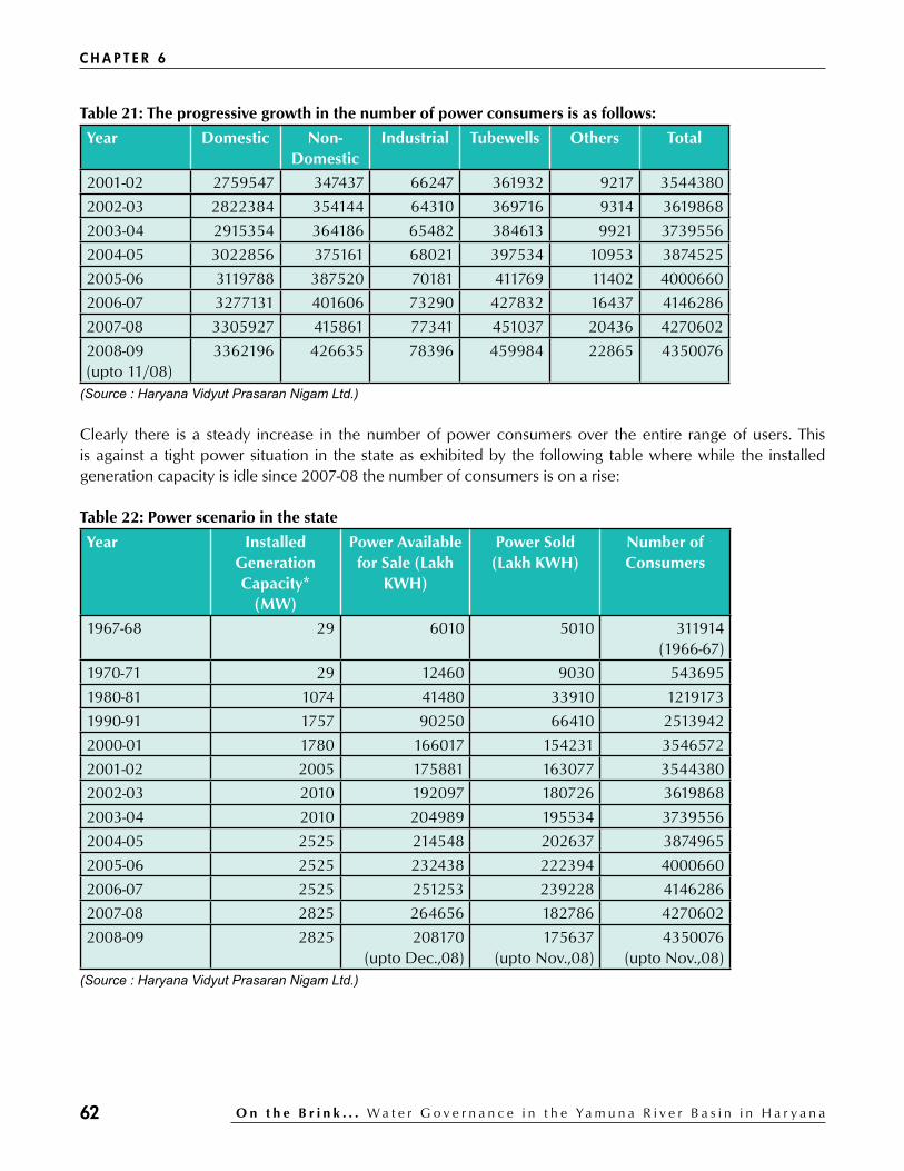
62 O n t h e B r i n k . . . W a t e r G o v e r n a n c e i n t h e Ya m u n a R i v e r B a s i n i n H a r y a n a
Table 21: The progressive growth in the number of power consumers is as follows:
Year Domestic Non-Domestic
Industrial Tubewells Others Total
2001-02 2759547 347437 66247 361932 9217 3544380
2002-03 2822384 354144 64310 369716 9314 3619868
2003-04 2915354 364186 65482 384613 9921 3739556
2004-05 3022856 375161 68021 397534 10953 3874525
2005-06 3119788 387520 70181 411769 11402 4000660
2006-07 3277131 401606 73290 427832 16437 4146286
2007-08 3305927 415861 77341 451037 20436 4270602
2008-09 (upto 11/08)
3362196 426635 78396 459984 22865 4350076
(Source : Haryana Vidyut Prasaran Nigam Ltd.)
Clearly there is a steady increase in the number of power consumers over the entire range of users. This is against a tight power situation in the state as exhibited by the following table where while the installed generation capacity is idle since 2007-08 the number of consumers is on a rise:
Table 22: Power scenario in the state
Year Installed Generation Capacity*
(MW)
Power Available for Sale (Lakh
KWH)
Power Sold (Lakh KWH)
Number of Consumers
1967-68 29 6010 5010 311914 (1966-67)
1970-71 29 12460 9030 543695
1980-81 1074 41480 33910 1219173
1990-91 1757 90250 66410 2513942
2000-01 1780 166017 154231 3546572
2001-02 2005 175881 163077 3544380
2002-03 2010 192097 180726 3619868
2003-04 2010 204989 195534 3739556
2004-05 2525 214548 202637 3874965
2005-06 2525 232438 222394 4000660
2006-07 2525 251253 239228 4146286
2007-08 2825 264656 182786 4270602
2008-09 2825 208170 (upto Dec.,08)
175637 (upto Nov.,08)
4350076 (upto Nov.,08)
(Source : Haryana Vidyut Prasaran Nigam Ltd.)
C H A P T E R 6

63O n t h e B r i n k . . . W a t e r G o v e r n a n c e i n t h e Ya m u n a R i v e r B a s i n i n H a r y a n a
Despite the above the power tariff system in the state provides a choice to a farmer of payment based on meter charge or a pre-fixed monthly amount independent of the power use. This system where the consumers as well as the power supplier for ease of collections opts for the latter, results in the following:a) Drawal of power in excess of what is actually needed since monthly charges should be fully ‘utilised’b) Over extraction of ground water both for watering of the field as well as public and private drinking water
supplies in the village
The above situation is also a result of the fact that since the power supply is uncertain and erratic so the consumer tends to use it (no matter one needs it or not) as long as it lasts! As was learnt at the workshop held on 26th July 2010 at Panipat that the uncertainty in power supplies motivates a farmer to over irrigate his fields to insure against possible unavailability of power and thus lack of water for at least a weeks time.
It is reported (pers. comm. Sanjay Verma, Director Tariff, HERC) that the actual cost of power on an average is Rs 4 – 4.50 per unit, but the farmer is being provided the same at 25 paise per unit (metered connection) and Rs 35 per BHP per month (flat monthly charges). It was reported that the state government subsidy which stood at Rs 750 crores in the year 2000-01 had by the year 2010-11 increased to Rs 2964 crores. The state government’s policy to waive off pending electricity bills of farmers from time to time is also not helping the power sector in the state.
Thus it is a strange cycle where low power charge recoveries (emanating from populist policies) for agricultural use results in poor and erratic power supply situation which in turn results in distress over harvest of ground water by the farmer whenever there is power supply available.
It is thus no wonder that the Planning Commission has advised the Haryana government to impose a cess on electricity used for cultivation and use the funds to replenish depleting ground water. The country’s apex planning body has expressed its concern over state’s rapidly falling water table, reportedly at the rate of 0.33 meters every year. (Source: http://economictimes.indiatimes.com/news/economy/policy/Cess-on-farm-power-mooted-to-boost-water-table/articleshow/6021881.cms)
There is another point of view (learnt at the workshop) that as long as the state was predominantly primary sector (agriculture and allied) based, the power subsidy helped in rapid increase in agricultural production. But now with more and more power being diverted from agriculture for meeting the industrial and service sector needs, the farmer is being forced to mis-utilise the uncertain and erratic power supply to extract as much ground water as and when the power supply is available.
We were also informed in the field by a contractor in-charge of maintaining a STP that one of the reasons for his inability to run the STP properly is the fact that the power meant for the STP’s use is often diverted to meet the industrial needs.
The above unverified reasoning gets some kind of validation from senior officials of the HERC (pers. comm. Sanjay Verma, Director Tariff, HERC) when preferred supplies to industries over other sectors is admitted as it is helpful for the agency’s financial health. This is also justified on the grounds that the industrial demand is going up by 8-10 % per annum, and the supply to it is of high quality (higher returns) there is also no theft of power and prompt payment of the requisite charges is assured.
S t u d y F i n d i n g s

64 O n t h e B r i n k . . . W a t e r G o v e r n a n c e i n t h e Ya m u n a R i v e r B a s i n i n H a r y a n a
But the fact that this assured power supply to the industry (many of which have ground water dependencies) may also be inadvertently resulting in over draft of ground water by the industry does not seem to yet figure in any sense of inter-relatedness between preferred power supply and ground water utilisation by the industry.
It may be worthwhile to mention here that during our initial field visits when we approached the UHBVNL (Uttar Haryana Bijli Vitran Nigam Limited) officials for information and briefed them about our project they expressed surprise on our approaching them, mentioning as to what relation could there possibly be between water conservation and power supplies?
6.7 Waste Water (Including Sewage) Treatment Leaves a Lot to Desire while the Production of Waste Water is on an Increase
One of the direct results of the transformation of economy from primary to secondary and tertiary sectors is the increased production of waste water and a need to address its treatment and use / safe disposal.
On the national scale, the problem of sewage treatment first came into focus in 1986 with the launch of Ganga Action Plan (GAP), which is now National River Conservation Program in the Ministry of Environment and Forests, MOEF. Abatement of pollution of the river to improve its water quality was the key objective of the plan. In 1993, the Yamuna Action Plan (YAP) with special assistance of Japan Bank for International Cooperation (JBIC) was launched on lines similar to the GAP. Fifteen (15) towns in the state of Haryana, UP, and Delhi were included. The YAP consisted of core (STPs) and non core (low cost sanitation, bathing ghats, crematoria etc) schemes to deal with both point source and non point sources of pollution (AHEC, 2002).
The current state of sewage generation and treatment capacity in towns in the study area is:
Table 23: Sewage generation and treatment capacity in cities in study area
S. No
Name State Population Sewage Treatment capacity
Disposal
1 Panipat Haryana 345400 26.7 45 Yamuna
2 Sonepat Haryana 285400 21.2 30 Yamuna(Source: CPCB, 2009)
The sewage treatment plants both at Panipat (10 MLD and 35 MLD) and at Sonepat (30 MLD) were completed in 1999 – 2000 at a cost of Rs 1642 and Rs 1051 lakhs respectively, excluding the cost of MPS (Main Pumping Station). A performance review of these was carried out by the Alternate Hydro Energy Centre at IIT, Roorkee in the year 2002. This review which was sponsored by the NRCD (MoEF) covered all the schemes at all the 15 cities undertaken under the YAP I.
C H A P T E R 6

65O n t h e B r i n k . . . W a t e r G o v e r n a n c e i n t h e Ya m u n a R i v e r B a s i n i n H a r y a n a
According to the review (AHEC, 2002) in the six towns in Haryana incorporated under YAP:
“Most of the drain have been intercepted and divested to STPs which are based on UASB with polishing ponds and waste stabilization ponds. All STP are working satisfactorily although all of them are under-loaded. The treated effluent from STPs is being discharged in drains or canals and there is no organized use, and no revenue is being generated. The dried sludge is being sold to farmers and the acceptability is good. The utilization of biogas is poor as most of it is being flared and only a small percentage is utilized in running DFGs.”
It may be noted that as against the above situation reported in 2002, at least in the three STPs at Panipat and Sonepat that we observed during our field visits in 2010 the STPs were either not working or working erratically and at low efficiency. The PHED which is responsible for O&M of the plants has outsourced the same to little trained contractors.
Both at Sonepat and at Panipat, the effluents (whatever is emerging from the STP) is being discharged into nearby drains (Drain No 6 at Sonepat and Panipat Drain at Panipat) which carry the city’s waste water and the treated effluents are no more than a drop in the ocean of untreated waste water flowing in these drains (pic 13, 16).
Both the sludge and biogas (no longer being produced or flared) are almost things of the past and not serving any useful purpose.
In short the usefulness of the STPs is a matter of serious concern at both the places seen by us.
While the existing facilities are working at far below efficiency, increasing population, industrialization and urbanization is bound to add to their loads. While there are plans to construct more STPs by the PHED, unless the former’s operation and maintenance needs are addressed in a far more professional manner than are carried out presently there is a serious doubt on either the existing STPs or new ones making much difference to the problem of waste water treatment and disposal.
S t u d y F i n d i n g s

66 O n t h e B r i n k . . . W a t e r G o v e r n a n c e i n t h e Ya m u n a R i v e r B a s i n i n H a r y a n a
Trends, Consequences and Options
7.1 Trends And Issues In Water Governance
Trends as understood from the study findings and their implications for water governance in the state are presented here.
7.1.1 Competing demands on canal water supplies/flows
Competing sectorsa) Irrigation (agriculture)b) Industryc) Drinking water d) Service sector (Housing, Tourism, others)e) Ground water recharge
Agencies involvedIrrigation; Agriculture; PHED; Industry; HUDA; Tourism
Governance issuesa) Prioritising and allocating canal water supplies b) Usefulness and impacts of externally aided projects c) Water User Associations (WUA)d) State Water Plan (SWP) e) Equity in water use
7.1.2 Falling water table
Facilitatora) Unregulated extraction from underground for irrigation; domestic use; industry; service sectorb) User’s ability to dig deeper and deeper for waterc) Incompatible agricultural practicesd) Wasteful consumption of available watere) Free or heavily subsidized power supplyf) Lining of water coursesg) Drying of river bed/channel and water courses
Relevant agenciesIrrigation; PHED; Agriculture; Industry; Power; Tourism; HUDA; Forests
chapter 7

67O n t h e B r i n k . . . W a t e r G o v e r n a n c e i n t h e Ya m u n a R i v e r B a s i n i n H a r y a n a
Governance issuesa) Conservation of ground water b) Water conserving cropping system c) Recharge of ground waterd) Flows in river and other water courses e) Lined water courses including canal/distributary/minorsf) Subsidized power supply g) Village pondsh) Catchment forests
7.1.3 Wasteful use of available water
Facilitatora) Easy availability (presently) of water both in urban and rural areasb) Absence of respect for water as a life sustaining entityc) Water and power tariff ratesd) Absence of social and legal prohibition against wastage of watere) Life style changes (materialism, consumption and waste as accepted norms)
Relevant agenciesIrrigation; Agriculture; PHED; Power; Education; Tourism; HUDA
Governance issuesa) Water tariffb) Power tariffc) Legal prohibition on wastage of waterd) Regulation on use of water extraction equipment like submersible pumpse) Organic agriculture for water conservationf) Recycle and treatment of used water.g) Conservation of water in educational campaigns
7.1.4 Increasing production of waste / polluted water
Facilitatora) Over use of available water for various usesb) Urbanisation; Industrialisation; Service sectorc) Poor sanitation conditions in urban and rural areasd) Poor sewerage and drainage systems both in urban and rural arease) Subsidized power and water f) High inputs agricultural practices
Relevant agenciesPHED; Irrigation; Agriculture; Industry; Pollution Control Board; Panchayat; Tourism; Municipality; Power
T r e n d s , C o n s e q u e n c e s a n d O p t i o n s

68 O n t h e B r i n k . . . W a t e r G o v e r n a n c e i n t h e Ya m u n a R i v e r B a s i n i n H a r y a n a
Governance issuesa) Sanitation and sewerage systems in urban and rural areasb) Waste water management (cleaning / treatment / recycle) c) Pollution prevention measures by the Industryd) CSR (Corporate Social Responsibility) and waste water managemente) Power and water tariff as regulator on waste water creationf) Promotion of organic agricultural practices
7.1.5 Pauperisation of the river and the dependent people/life forms
Facilitatora) Increasing extraction over time of water from the riverb) Desiccation and disuse of natural tributaries of the riverc) Drying of the river bed in the lean seasond) Encroachment into the river bed by agriculture and human habitatione) Drinking water schemes for far off towns based on ground water extracted from river bed / flood plainsf) Pollution from drains falling into the riverg) Disposal of solid waste into the riverh) Sand mining in the river bedi) Clearing of natural vegetation and trees from the river side
Relevant agenciesIrrigation; Agriculture; PHED; SPCB; Forest; Mining
Governance issuesa) Flows in the riverb) Drains falling into the riverc) Pollution of river bedd) River bed and flood plains encroachment e) Water dependence on river of people / villages lying on the river banksf) Sand mining from the river bedg) Security of catchment forests /Plantations alongside the river
Over all impact of the above is a looming crisis of fresh water availability and the compromising of human and livestock health in the area under study.
C H A P T E R 7

69O n t h e B r i n k . . . W a t e r G o v e r n a n c e i n t h e Ya m u n a R i v e r B a s i n i n H a r y a n a
7.2 Options
Based on the learnings from the study, two options, one called as “Business as usual” and the other as “Business NOT as usual” are presented.
7.2.1 Business as Usual
Table 24: Scenario and Consequences (BAU)
Scenario Consequence
Not enough water in the canals 1. Essential requirements (industries, service sector, towns and water for domestic use) receive preference for water over irrigation.
2. Canal irrigation prioritised for lands in the salinity affected or water scarce areas (western, central and south) of the state
No water in the river Aquifers connected to the river go dry
Ground water extracted by farmer, industry, service sector and the government
Water table continues to go down
Increased production of waste water (Urbanisation, industry and service sector)
Water continues to go waste
Part / poor treatment / disposal of waste water Increased pollution of surface and ground water sources
Increased water stress (low availability, poor quality, high rates)
1. Adverse all round impacts on most sectors (agriculture, industries, service)
2. Rise of water tanker mafia3. Increased water related social conflicts and health
problems.
7.2.2 Business NOT as usual
Presumptiona) River as a life-line is brought back into planning processb) Ground water extraction and use becomes conservative (regulation and education)c) Treated waste water is seen as a valuable ‘resource’d) Cropping patterns are made more water ‘friendly’e) Agriculture, industry, service sector all see treated waste water as being an integral part of their conjunctive
water use practice/s
Table 25: Scenario and Consequences (Business NOT as usual)
Possible scenario Consequences
Water needs of the river are appreciated, assessed and made good
1. River flows round the year. 2. River connected aquifers get regularly recharged at no investment.
A cap is fixed on the upper limit of fresh water abstracted from the river keeping the needs of the river in mind
Fresh water flows both in river and in the canals
T r e n d s , C o n s e q u e n c e s a n d O p t i o n s

70 O n t h e B r i n k . . . W a t e r G o v e r n a n c e i n t h e Ya m u n a R i v e r B a s i n i n H a r y a n a
Possible scenario Consequences
Fresh water supplies are strictly rationed for all users
Water is a scarce resource is understood and agreed by all kinds of users
Further lining of canals and water courses are prohibited
Opportunities for ground water recharge are not compromised
Canal water supplies are efficiently allocated and managed
Minimum fresh water needs of irrigation, industry, drinking water from the canal waters are met
Ground water use and extraction is strictly regulated through policy and legal action
Water table revives through annual monsoon season recharge
Ground water recharge becomes a state level mission
1. Natural water bodies (ponds) in urban and rural areas are revived.2. Old wells/tube wells become source of recharge
Conjunctive use of water (fresh and treated waste water); recycle of water by agriculture, industry and service sector becomes a policy and legal requirement
STPs and ETPs work at full capacity, efficiency and accountability as only then would treated waste water become fit for use in conjunction with the fresh water from rain fall, ground and the canal supplies.
Efficient water drainage in urban and rural areas becomes a priority with the all concerned and an important part of CSR of industry
1. No water standing idle on road / railway sides.2. Decrease in health related risks to humans/cattle.
Water availability for various uses (agriculture, industry, service sector and drinking) remain within manageable limits
Adverse impacts from impending ‘water stress’ on various sectors are prevented.
C H A P T E R 7
Quod erat demonstrandum (Q.E.D.) “that which was to be demonstrated”

71O n t h e B r i n k . . . W a t e r G o v e r n a n c e i n t h e Ya m u n a R i v e r B a s i n i n H a r y a n a
references
Anonymous, 2002. z Performance Review of Yamuna Action Plan. Alternate Hydro Energy Centre, Roorkee. National River Conservation Directorate. Ministry of Environment & Forests, New Delhi. Anonymous, 2007, z Project to increase the capacity of Western Yamuna Canal (Main Line Lower), Haryana Irrigation Department Anonymous, 2008. Director of Land Records (2007-08) z
Anonymous, 2009. z Status of water supply, wastewater generation and treatment in class-I cities & class-II towns of India, Central Pollution Control Board (CPCB). New Delhi. Anonymous, 2009. z Department of Economics and Statistical Analysis. Anonymous, 2009. z Economic Survey of Haryana, 2008-09 Anonymous, undated. z Guidelines, Bye-laws, MOU for Formation of Water Users Association, HIRMI, Kurukshetra. Anonymous, undated, z Haryana State Gazetteer Vol. II, History of Agriculture Anonymous, undated. z Major Water Resources Development Projects in Ganga basin.National Institute of Hydrology (NIH), Roorkie (http://www.nih.ernet.in/nih_rbis/india_information/Ganga_projects.htm) Anonymous, 2003. z Pilot Study on Water Use Efficiency for Western Yamuna Canal (Haryana). Planning Commission, Government of India. Water and Power Consultancy Services (WAPCOS), Gurgaon (Haryana). Dubash N.K., 2005. z The Electricity-Groundwater Conundrum: The Case for a Political Solution to a Political Problem. National Institute of Public Finance and Policy (Paper presented at 4th IWMI-Tata Annual Partners Meet Feb 24-26 2005) Dutta, Ritwick. 2009. z The Unquiet River – An Overview of Select decisions of the Courts on the River Yamuna. PEACE Institute Charitable Trust. Delhi. Endersbee, L., z A voyage of discovery: A history of ideas about the earth, with a new understanding of the global resources of water and petroleum, and the problems of climate change. Frankston, Victoria, Australia: Monash University Bookshop, 2005, pp. 300 Haryana Irrigation Department (HID), 2007. Hathkinund Barrage. Haryana Water Resources Consolidation z
Project (Credit 2592-IN). Water Services Division, Dadupur. Hellegers, P.J.G.J., C.J. Perry and J. Berkoff (2007). z Water Pricing in Haryana, India. In Irrigation Water Pricing (eds F. Molle and J. Berkoff), CAB International 2007 http://cgwb.gov.in/groundwater/conjunctive_use.htm accessed on 280710 z
http://economictimes.indiatimes.com/news/economy/policy/Cess-on-farm-power-mooted-to-boost- z
water-table/articleshow/6021881.cms http://www.cpcb.nic.in/newitems/11.pdf accessed on 270710 z
http://envfor.nic.in/legis/legis_all.htm accessed on 060810 z
http://igovernment.in/site/haryana-plans-rs-406-cr-irrigation-scheme-37926 accessed on 080810 z
http://moef.nic.in/downloads/about-the-ministry/introduction-psap.pdf accessed on 060810 z
http://moef.nic.in/modules/about-the-ministry/introduction/ accessed on 060810 z
http://moef.nic.in/modules/recent-initiatives/NRCD/table.htm accessed on 060810 z
http://mowr.gov.in/index2.asp?sublinkid=531&langid=1&slid=284 accessed on 070810 z
http://mowr.gov.in/index3.asp?sslid=340&subsublinkid=350&langid=1 accessed on 050810 z
http://mowr.gov.in/index3.asp?sslid=784&subsublinkid=772&langid=1 accessed on 050810 z
http://mowr.gov.in/index3.asp?subsublinkid=770&langid=1&sslid=782 accessed on 050810 z
http://mowr.gov.in/writereaddata/linkimages/cad_proj424966265.pdf accessed on 050810 z
http://web1.hry.nic.in/budget/Economic%20Survey%202009-10.pdf accessed on 090810 z

72 O n t h e B r i n k . . . W a t e r G o v e r n a n c e i n t h e Ya m u n a R i v e r B a s i n i n H a r y a n a
http://www.hinduonnet.com/thehindu/thscrip/pgemail.pl?date=2010/08/07/&prd) z
http://www.iwmi.cgiar.org/publications/CABI_Publications/CA_CABI_Series/WaterPricing/protected/ z
Molle%20&%20Berkoff_Chap%2008.pdf accessed online 20110. Panwar, H.S., 2009. z Reviving River Yamuna-An Actionable Blueprint for a Blue River. PEACE Institute Charitable Trust, Delhi. Puri, T.S. (Deputy Director, Haryana State Minor Irrigation and Tubewells Corporation, Hisar) (undated). z
Ground Water Management in Haryana. Sharma, S.K., 2009. z Proposal for Ground Water Recharge in National Capital Region (NCR). Singh, Hardeep, 2007. B z ackground Paper for the National Consultative Group. Society for Promotion of Wastelands Development. Delhi. Vohra, VP, undated. z Status of Water Resources Development in India with Special Reference to Haryana. WJC System of Haryana, Rotational Running of Canals and Equitable Distribution of Water Above and Below the Outlet.
R E F E R E N C E S

73O n t h e B r i n k . . . W a t e r G o v e r n a n c e i n t h e Ya m u n a R i v e r B a s i n i n H a r y a n a
Annexure 1
Memorandum of Understanding Between Uttar Pradesh, Haryana, Rajasthan, Himachal Pradesh and National Capital Territory of Delhi Regarding Allocation of Surface Flow of Yamuna
1. Whereas the 75% dependable notional virgin flow in the Yamuna river upto Okhla has been assessed as 11.70 Billion Cubic Metres (BCM) and the mean year availability has been assessed as 13.00 BCM
2. And whereas the water was being utilized by the Basin States Ex-Tajewala and ex-Okhla for meeting the irrigation and drinking water needs without any specific allocation.
3. And whereas a demand has been made by some basin states on this account and the need for a specified allocation of the utilizable water resources of river Yamuna has been felt for a long time.
4. And whereas to maximize the utilization of the surface flow of river Yamuna a number of storage projects have been identified.
5. And whereas the States have agreed that a minimum flow in proportion of completion of upstream storages going upto 10 cumec shall be maintained downstream of Tajewala and downstream of Okhla Headworks throughout the year from ecological considerations, as upstream storages are built up progressively in a phased manner.
6. And whereas it has been assessed that a quantum of 0.68 BCM may not be utilizable due to flood spills.7. Now therefore, considering their irrigation and consumptive drinking water requirements, the Basin States
agree on the following allocation of the utilizable water resources of river Yamuna assessed on mean year availability.
a) Haryana 5.730 BCMb) Uttar Pradesh 4.032 BCMc) Rajasthan 1.119 BCMd) Himachal Pradesh 0.378 BCMe) Delhi 0.724 BCM
Subject to following
(i) Pending construction of the storages in the upper reaches of the river, there shall be an interim seasonal allocation of the annual utilizable flow of river Yamuna as follows:
States Seasonal Allocation of Yamuna Waters (BCM)
July-Oct Nov-Feb March-June Annual
Haryana 4.107 0.686 0.937 5.730
Uttar Pradesh 3.216 0.343 0.473 4.032
Rajasthan 0.963 0.070 0.086 1.119
H i m a c h a l Pradesh
0.190 0.108 0.080 0.378
Delhi 0.580 0.068 0.076 0.724
Total 9.056 1.275 1.652 11.983
Provided that the interim seasonal allocations will be distributed on ten daily basis.
annexures

74 O n t h e B r i n k . . . W a t e r G o v e r n a n c e i n t h e Ya m u n a R i v e r B a s i n i n H a r y a n a
Provided further that the said interim seasonal allocations shall get progressively modified, as storages are constructed to the final annual allocations as indicated in para 7 above.(i) Separate agreement will be executed in respect of each identified storage within the framework of overall
allocation made under the agreement.(ii) The allocation of available flows amongst the Beneficiary States will be regulated by the Upper Yamuna
River Board within the overall framework of this agreement.
Provided that in a year when the availability is more than the assessed quantity, the surplus availability will be distributed amongst the States in proportion to their allocations.
Provided also that in a year when the availability is less than the assessed quantity, first the drinking water allocation of Delhi will be met and the balance will be distributed amongst Haryana, U.P., Rajasthan and H.P., in proportion to their allocations.
8. This agreement may be reviewed after the year 2025, if any of the basin States so demand.9. We place on record and gratefully acknowledge the assistance and advice given by the Union Minister of
Water Resources in arriving at the expeditious and amicable settlement.
New Delhi, the 12th May, 1994
-Sd-(Mulayam Singh Yadav)
Chief MinisterUttar Pradesh
-Sd-(Bhajan Lal)
Chief MinisterHaryana
-Sd-(Bhairon Singh
Shekhawat)Chief Minister
Rajasthan
-Sd-(Virbhadra Singh)
Chief MinisterHimachal Pradesh
-Sd-(Madan Lal Khurana)
Chief MinisterDelhi
A N N E X U R E 1 ( C o n t d . )
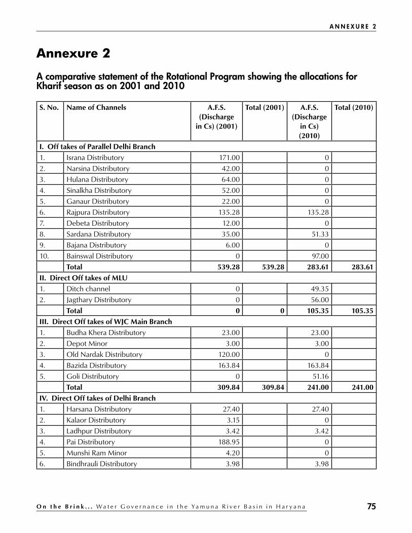
75O n t h e B r i n k . . . W a t e r G o v e r n a n c e i n t h e Ya m u n a R i v e r B a s i n i n H a r y a n a
Annexure 2
A comparative statement of the Rotational Program showing the allocations for Kharif season as on 2001 and 2010
S. No. Name of Channels A.F.S. (Discharge
in Cs) (2001)
Total (2001) A.F.S. (Discharge
in Cs) (2010)
Total (2010)
I. Off takes of Parallel Delhi Branch
1. Israna Distributory 171.00 0
2. Narsina Distributory 42.00 0
3. Hulana Distributory 64.00 0
4. Sinalkha Distributory 52.00 0
5. Ganaur Distributory 22.00 0
6. Rajpura Distributory 135.28 135.28
7. Debeta Distributory 12.00 0
8. Sardana Distributory 35.00 51.33
9. Bajana Distributory 6.00 0
10. Bainswal Distributory 0 97.00
Total 539.28 539.28 283.61 283.61
II. Direct Off takes of MLU
1. Ditch channel 0 49.35
2. Jagthary Distributory 0 56.00
Total 0 0 105.35 105.35
III. Direct Off takes of WJC Main Branch
1. Budha Khera Distributory 23.00 23.00
2. Depot Minor 3.00 3.00
3. Old Nardak Distributory 120.00 0
4. Bazida Distributory 163.84 163.84
5. Goli Distributory 0 51.16
Total 309.84 309.84 241.00 241.00
IV. Direct Off takes of Delhi Branch
1. Harsana Distributory 27.40 27.40
2. Kalaor Distributory 3.15 0
3. Ladhpur Distributory 3.42 3.42
4. Pai Distributory 188.95 0
5. Munshi Ram Minor 4.20 0
6. Bindhrauli Distributory 3.98 3.98
A N N E X U R E 2

76 O n t h e B r i n k . . . W a t e r G o v e r n a n c e i n t h e Ya m u n a R i v e r B a s i n i n H a r y a n a
S. No. Name of Channels A.F.S. (Discharge
in Cs) (2001)
Total (2001) A.F.S. (Discharge
in Cs) (2010)
Total (2010)
7. Sonepat Distributory 22.60 22.60
8. Bayanpur Minor 4.00 0
9. Dua Distributory 110.30 110.30
10. Mohamdabad Minor 3.36 3.36
11. Direct outlet on Delhi Branch/Delhi Sub Branch
0 39.00
12. Israna Distributory 0 171.00
13. Narayana Distributory 0 42.00
14. Carrier Channel (Israna Link Channel) 0 20.00
Total 371.36 371.36 443.06 443.06
V. Direct Off takes of Bhalaut S/Branch
1. Lath Minor 10.00 10.00
2. Rothak Distributory 11.55 111.65
3. Rithal Distributory 17.50 17.60
4. Jasrana Minor 89.00 89.00
5. Dhamar Minor 4.00 2.15
6. Makrauli Minor 24.50 0
7. Bohar Distributory 30.00 30.00
8. Bhaulaut Distributory 76.58 76.58
9. New Kaioi Minor 10.00 10.00
10. Pahrawar Minor 6.47 6.47
11. Khari Sadh Minor 4.60 4.60
12. Dulhera Distributory 382.00 382.00
13. J.S.B. Excluding Partuwas, S.L.C. Bhakra Minor, Machrauli Distributory, Chuchakwass Minor & Marot Minor
420.45 419.00
15. W.W.T 43.15 43.15
16. Direct outlets on Bhalaut Sub Branch 0 26.69
17. Absorption losses in Bhalaut Sub Branch
0 22.71
Total 1129.8 1129.8 1251.6 1251.6
VI. Additional Requirement at Munak
1. HTP 523.00 485.00
2. PTP 80.00 90.00
3. NFL 40.00 45.00
4. GWS 70.00 138.00
A N N E X U R E 2 ( C o n t d . )

77O n t h e B r i n k . . . W a t e r G o v e r n a n c e i n t h e Ya m u n a R i v e r B a s i n i n H a r y a n a
S. No. Name of Channels A.F.S. (Discharge
in Cs) (2001)
Total (2001) A.F.S. (Discharge
in Cs) (2010)
Total (2010)
5. P.N.C.P 0 45.00
6. Addn. Losses 25.00 25.00
Total 738.00 738.00 828.00 828.00
VII. Refinery Channel 30.00 30.00 35.00 35.00
VIII. For Minimum flow on Yamuna below Wazirabad
240.00 240.00 165.00 165.00
Ix Delhi Jal Board 92.00 92.00
x Transit Losses from Tajewala to Munak & NBK+SYL
516.00 516.00
xI C.L.C. 400.00 400.00
Total requirement of Bhalaut Group 4360.62 4360.62
Name of Channels Total A.F.S. Discharge in Cs
(2001)
Total A.F.S. Discharge in Cs
(2010)
Off takes of Parallel Delhi Branch 539.28 283.61
Direct Off takes of MLU 0 105.35
Direct Off takes of WJC Main Branch 309.84 241.00
Direct Off takes of Delhi Branch 371.36 443.06
Direct Off takes of Bhalaut S/Branch 1129.8 1251.6
Additional Requirement at Munak 738.00 828.00
Refinery Channel 30.00 35.00
For Minimum flow on Yamuna below Wazirabad 240.00 165.00
Delhi Jal Board 0 92.00
Transit Losses from Tajewala to Munak & NBK+SYL
0 516.00
C.L.C. 0 400.00
Total requirement of Bhalaut Group 3358.28 4360.62
A N N E X U R E 2 ( C o n t d . )

78 O n t h e B r i n k . . . W a t e r G o v e r n a n c e i n t h e Ya m u n a R i v e r B a s i n i n H a r y a n a
Sunder + NDK
S. No. Name of Channels A.F.S. (Discharge in
Cs) (2001)
Total (2001) A.F.S. (Discharge
in Cs) (2010)
Total (2010)
I. Direct Off Takes of NBK Link
1. Nardak Distributory 393.00 0
2. Gogripur Distributory 8.39 8.39
Total 401.39 401.39 8.39 8.39
II. Direct Off Takes of Hansi Branch
1. Jind No. 1 33.00 33.00
2. Joshi Distributory 23.00 23.00
3. Jind No. 2 6.80 0
4. Jind Distributory 3. 228.50 228.50
5. Direct outlets on Hansi Branch 0 1.40
6. Absorption losses in Hansi Branch 0 20.00
Total 291.30 291.30 305.90 305.90
III. Direct Off Takes of Hansi Branch D/S Anta
1. Muana Distributory 35.30 55.30
2. Jind Distributory No. 4 70.00 70.00
3. Jind Distributory No. 5 55.40 55.40
4. Jind Distributory No. 6 34.50 34.50
5. Jind Distributory No. 6A 25.00 25.00
6. Jind Distributory No. 7 26.00 26.00
7. Jind No. 8 10.00 10.00
8. New Rajpura Minor 8.50 8.50
9. Masudpur Distributory 115.00 80.00
10. Narnaund Distributory 35.00 35.00
11. Hisar Major 300.00 300.00
12. PTR Dy. Including Sewani Canal 536.00 336.00
13. New Dewani FDR L/C 11 Cs. For Harita
141.00 0
14. Direct outlets on Hansi Branch 0 17.23
15. Absorption losses in Hansi Branch 0 122.97
Total 1391.70 1391.70 1175.90 1175.90
IV. Direct Off Takes of Butana Branch
1. Gangesar Distributory 29.70 29.70
2. Butana Distributory 154.00 154.00
A N N E X U R E 2 ( C o n t d . )

79O n t h e B r i n k . . . W a t e r G o v e r n a n c e i n t h e Ya m u n a R i v e r B a s i n i n H a r y a n a
S. No. Name of Channels A.F.S. (Discharge in
Cs) (2001)
Total (2001) A.F.S. (Discharge
in Cs) (2010)
Total (2010)
3. Direct outlets on Butana Branch 0 51.53
4. Absorption losses in Butana Branch 0 27.86
Total 183.70 183.70 263.09 263.09
V. Off Takes of Sunder Sub Branch
1. Ludana Minor 24.10 24.10
2. Quila Z-garh 31.50 31.50
3. Karsola Distributory 75.50 75.50
4. Brarkhera Minor 20.50 20.00
5. Jamani Khera Minor 23.25 23.25
6. Khani Kheri Minor 7.60 7.60
7. Bhaklana Minor 12.70 12.70
8. M.S.L. 17.00 17.00
9. Jui Feeder 550 500.00
10. Mithathai Feeder 284.00 250.00
11. D/S 121 S.S.B. 564.00 465.00
12. Direct outlet on Sunder Sub Branch 0 63.00
13. Absorption losses in Sunder Sub Branch
0 100.00 (54+46)
14. Additional losses & outlets of Butana Branch from RD 83 to Tail
0 0
Total 1610.15 1610.15 1589.65 1589.65
VI. Off Takes of Parallel Delhi Branch
1. Israna Distributory 171.00 0
2. Narsina Distributory 42.00 0
3. Hulana Distributory 64.00 0
4. Sinalkha Distributory 52.00 0
5. Ganaur Distributory 22.00 0
6. Rajpur Distributory 135.28 0
7. Debeta Distributory 12.00 0.28
8. Sardana Distributory 35.00 0
9. Bajana Distributory 6.00 6.00
Total 539.28 539.28 6.28 6.28
VII. Direct Outlets on
1. Delhi Branch & Delhi Sub Branch 39.00 39.00
VIII. Additional Requirement at Munak
1. HTP 523.00 485.00
2. PTP 80.00 90.00
A N N E X U R E 2 ( C o n t d . )

80 O n t h e B r i n k . . . W a t e r G o v e r n a n c e i n t h e Ya m u n a R i v e r B a s i n i n H a r y a n a
S. No. Name of Channels A.F.S. (Discharge in
Cs) (2001)
Total (2001) A.F.S. (Discharge
in Cs) (2010)
Total (2010)
3. NFL 40.00 45.00
4. GWS 70.00 138.00
5. P.N.C.P. 0 45.00
6. Additional Losses 25.00 25.00
Total 738.00 738.00 828.00 828.00
Ix. Refinery Channel 30.00 30.00 35.00 35.00
x. For Minimum Flow on Yamuna on Below Wazirabad
240.00 240.00 165.00 165.00
xI. Delhi Jal Board 0 0 92.00 92.00
xII. Transit losses from Tajewala to Munak & NBK+SYL
0 0 516.00 516.00 (319+197)
xIII. C.L.C. 0 0 400.00 400.00
Total requirement of the Group 5464 5424 5424
Channels of Narwana Sirsa Branch System to be Added in WJC System (N.D.K.)
Name of Channels Total A.F.S. Discharge in Cs
(2001)
Total A.F.S. Discharge in Cs
(2010)
Direct Off Takes of NBK Link 401.39 8.39
Direct Off Takes of Hansi Branch 291.30 305.90
Direct Off Takes of Hansi Branch D/S Anta 1391.70 1175.90
Direct Off Takes of Butana Branch 183.70 263.09
Off Takes of Sunder Sub Branch 1610.15 1589.65
Off Takes of Parallel Delhi Branch 539.28 6.28
Direct Outlets on Delhi Branch 39.00 39.00
Additional Requirement at Munak 738.00 828.00
Refinery Channel 30.00 35.00
For Minimum Flow on Yamuna on Below Wazirabad
240.00 165.00
Delhi Jal Board 0 92.00
Transit losses from Tajewala to Munak & NBK+SYL
0 516.00
C.L.C. 0 400.00
Total requirement of the Group 5464.52 5424.21
A N N E X U R E 2 ( C o n t d . )

81O n t h e B r i n k . . . W a t e r G o v e r n a n c e i n t h e Ya m u n a R i v e r B a s i n i n H a r y a n a
Annexure 3
Draft Policy for Rice Shoots for Kharif – 2010
No. 4279-99/7BWS/1417/65-Vol.XXVI Dated 14.6.2010
From:Engineer-in-ChiefIrrigation Department, HaryanaPanchkula
To:All Chief EngineersIrrigation Department, HaryanaPanchkula
Subject: Policy for Rice Shoots for the Kharif 2010
Please find enclosed herewith Rice Shoot Policy for Kharif 2010 as approved by Government vide Memo No. 2627-F dated 9.6.2010. The policy may be followed strictly.
Executive EngineerDA/As above For Chief Engineer/BWSU, Irri. Dept.,
Haryana, Panchkula
CC: 1. All Superintending Engineers, Water Services Unit, Haryana Irrigation Department2. General Manager, Haryana Irrigation Department, Panchkula3. Executive Engineer, Regulation, Haryana Irrigation Department, Panchkula4. Executive Engineer G & T, Haryana Irrigation Department, Panchkula.5. Executive Engineer, YWS, Executive Engineer, LCU & Executive Engineer/Co-ordination, Haryana Irriga-
tion Department, Panchkula.6. PS to Finance Minister, for kind information of Hon’ble Finance Minister Haryana, Chandigarh.7. PS to FC & PS/Irrigation for kind information of Worthy FC & PS (I) 8. PS to Engineer-in-Chief for kind information of Worthy EIC9. Zilledar, Haryana Irrigation Department, Panchkula.
For information and necessary action.
DA/As above.
A N N E X U R E 3

82 O n t h e B r i n k . . . W a t e r G o v e r n a n c e i n t h e Ya m u n a R i v e r B a s i n i n H a r y a n a
Draft Policy for Rice Shoots for Kharif – 2010
DefinitionTemporary rice shoot is an outlet in Irrigation Channel with the aim of delivering discharge over and above the normal water allowance of the area exclusively of rice cultivation.
It is emphasized that no rice shoots are to be permitted on any Main Line, Branch Line or Feeder Channel as Government have decided that no outlets of any kind shall be provided on these channels.
These rice shoots are further termed as Contract temporary rice shots and the same are sanctioned subject to the execution of a contract agreement between the Government and the consumers according to which the latter are bound to use the water of temporary rice shoots exclusively for rice cultivation. According to this agreement, the whole area as stipulated therein is assessed on rice water rates, even if it is not cultivated.
W.J.C. SystemThe main rice growing area of Haryana state falls under WJC system and large number of temporary rice shoots are being allowed every year. At present temporary rice shoots are being allowed on the basis of the instructions issued vide Chief Engineer, I.B. Punjab letter no. 10026/G-II/Sub dated 30.3.62. The above instructions are also modified in Haryana state with certain additional provision vide Chief Engineer/Running Canals letter no. 3477/R.C./II/1709/65 dated 8.6.67 and No. 2124-27?F/1417/65 dated 13.6.68. Latest instruction of Kharif 1977 were issued vide Chief Engineer, Irrigation Works, Haryana letter no. 3532-82/RC/3/1417-65-VIII dated 16.5. 77. When the above mentioned instructions were issued, there was adequate surplus water available in River Yamuna during the flood season but the position changed with the construction of new lift non perennial channels and bringing new CCA of 654520 acres under Irrigation envisaged in WJC remodeling project. Areas which are experiencing increased water logging and salinity should be given rice shoots.A) Temporary rice shoots sanctioned on both the Canal system will be governed under the following
rules:i) There should be no shortage at the tail when the temporary rice shoots are sanctioned. This is the most
important criteria and should be rigidly followed. No relaxation be made.ii) Rice shoots should not be given on those channels where tails did not get proper and authorized irrigation
during the last two years.iii) The supply to the rice shoot outlets should be made after ensuring authorized fully supply to other farmers
on regular outlets.iv) No temporary rice shoots will be sanctioned to the persons found guilty of unauthorized irrigation during
the previous year. In case, however, it is not proved that cut has been made by particular person(s) temporary rice shoots will not be sanctioned to all the cultivators of such area.
v) Minimum area command for a temporary rice shoot will be 20 acres. vi) Traditional rice shoots should have priority over new temporary rice shoots. However, while allowing
traditional rice shoots, no fresh application is required and only processing fee may be got deposited at the time of agreement after full satisfaction of the concerned Executive Engineer, if there was no violation of approved policy during previous year.
vii) The last date for receipt of application, under this scheme for considering sanction of rice shoots will be upto 20th June 2010
(a) No application for sanction of rice shoots will be entertained without deposit of application.
A N N E X U R E 3 ( C o n t d . )

83O n t h e B r i n k . . . W a t e r G o v e r n a n c e i n t h e Ya m u n a R i v e r B a s i n i n H a r y a n a
(b) & (c) Application fee for old/traditional/new rice shoots will be Rs. 150/- per acre subject to a minimum of Rs. 3,000/- as the minimum area fixed for a rice shoot is 20 acres. Deposit of application fee does not imply sanction of the rice shoots.
(c) In case where Rice shoots are not sanctioned, 50% of the applications fee would be refunded to the application.
viii) Temporary rice shoots will be opened with effect from 15.7.10 with prior approval of Chief Engineer.ix) Temporary rice shoots will be allowed to run normally upto 30th September, 2010.x) Where the cultivators have sown rice crop in less than 50% of the area for which the temporary rice shoots
were sanctioned such cultivators should not be given a temporary rice shoot in the subsequent year.xi) No rice shoot be sanctioned after 15.7.2010 unless minimum of 10 acres has already been sown in the
area for which a rice shoot has been asked for, provided the discharge of rice shoot of a channel does not exceed 10% of its discharge at head and there is authorized water available at the tails.
xii) No rice shoot should be given on the channels upto the capacity of 10 Cs, unless provision for extra discharge during Kharif has been made in the capacity of the channel.
xiii) The rice shoots on a Distributory channel should not normally exceed 10% of the discharge at its head. For example, if the discharge at the head of Distributory is 150 Cs, the total discharge of the rice shoots should not normally exceed 15 Cs. However, this limit can be relaxed in case of channels to be specified if the Superintending Engineer is satisfied that tail will not suffer on this account and that the channel is capable of taking extra discharge. The names of such channel will be got approved/specified earlier form the Govt. It would be the responsibility of the Superintending Engineer and Chief Engineer to seek the approval of Govt. in such cases before 15th of June and they should not allow any rice shoot (outlet) in excess of 10% of its discharge at its head without prior approval of the Govt.
xiv) As far as possible the area covered under temporary rice shoots should be spread all over, from head to tail, so that there is no heavy withdraw of canal supplies due to concentration in a particular reach.
xv) The preference in the sanction of a temporary rice shoot (outlet) should be given to an applicant who has no tube well in the chak area of the rice shoots.
xvi) In case the irrigators have sown crops other than rice in an earmarked block under the temporary rice shoot then the rates for water charges for sown crops would also be levied in addition to the normal levy of water rates for rice crop under the agreement. This is liable to bar them from future sanction.
xvii) In case of joint application from more than one applicant, the rice shoot will be sanctioned in the name of all the applicants. However, if some applicants withdraw voluntarily, the rice shoot for remaining applicants shall be sanctioned provided areas left is minimum 20 acres and fulfill all other conditions of rice shoots policy, but no new applicant should be included.
xviii) Superintending Engineers are competent to sanction temporary rice shoots (new) in the manner as detailed under clauses xxi to xx to xxiiii.
xix) The concerned Divisional Canal Officer will scrutinize and decide the application of the eligible persons in accordance with the policy approved by the Govt. in particular year. He will send all the cases along with the cases which are not considered eligible by him to the Superintending Canal Officer for sanction of a temporary rice shoot. He will also send report specifying reasons why these cases are not eligible.
xx) Any person aggrieved by the decision of the Superintending Canal Officer can challenge the same by filing the representation within one week of the decision before the C.C.O. who will dispose off the same expeditiously.
xxi) After receipt of the recommendations of the Divisional Canal Officer the Superintending Canal Officer will take decision about the number of temporary rice shoots which can be sanctioned by him on that channel in accordance with the policy approved by the Govt. In case the number of the permissible outlets is
A N N E X U R E 3 ( C o n t d . )

84 O n t h e B r i n k . . . W a t e r G o v e r n a n c e i n t h e Ya m u n a R i v e r B a s i n i n H a r y a n a
exceeded the he will arrange to decide the cases on the basis of a draw of lots to be held on a day and time be decided at least 10 days in advance.
xxii) The list of eligible applicants will be notified and given-wide publicity. The draw should be held in the presence of at least three gazette officers to be appointed by the Superintending Engineer under whose Chairmanship the draw will be held. At least one officer out of these should not be connected, with the operation and maintenance of the concerned channel. The applicants should also be allowed to be present during draw time, if they so desire. On the basis of draw, the temporary rice shoots should be sanctioned by the Superintending Canal Officer and intimation sent to the Chief Canal Officer.
xxiii) If some of the applicants are not satisfied with the decision of the Divisional Canal Officer about the eligibility f his application, then he will have a right to approach the Superintending Canal Officer at least two days before the actual date of draw and the Superintending Canal Officer.
B) It will also be noted that:Rice shoots would be installed judiciously so that their running does not causes any flooding in the area. z
Rice shoots should not be allowed on any channel where the total availability of water is less than the z
normal requirement of the system. Rice shoots may not be given on minors and canals where there is a problem of water reaching the tail. z
Before processing the case for sanction of rice shoots the S.Es of Water Services Unit, Irrigation Department, z
Haryana should obtain the latest list of defaulters from Revenue Department and only those beneficiaries be asked to submit clearance certificate from Revenue Department whose names figure in latest list of defaulters. Rice shoots running continuously for last three years will be treated as Traditional Rice Shoots. z
Rice shoots should not be allowed on Main Canals, Branch Canals and Feeder Channels etc. z
C) No field officer of department will allow or recommend rice shoot i.e. Traditional / Temporary / New where Satthi Paddy (60 days crop) is sown by the Cultivators in the Canal Irrigation area and such type of Rice shoot be cancelled as Govt. of Haryana has already banned the Satthi Paddy (60 days Crop).
A N N E X U R E 3 ( C o n t d . )

85O n t h e B r i n k . . . W a t e r G o v e r n a n c e i n t h e Ya m u n a R i v e r B a s i n i n H a r y a n a
Annexure 4
Details of Field Visits
Date Months Team Members Highlights/ Place Visited
10-11 February Pushp Jain, Amita Bhaduri, Bhim
• Palla• DrainNo.8&6atKundali• Dy.DirectorAgri.Department,Sonepat• DistrictStatisticsOffice,Sonepat• WaterServicesDivision–Sonepat• MunakHead • MunakVillage • KarnalIrrigationCircle• AncientMughalCanal
09-10 March Hardeep Singh, Amita Bhaduri, Manoj Misra, Pushp Jain and Bhim
• AternaVillage• KhewaraVillage• JatJoshiVillage(Sonepat)• Dy.DirectorAgri.Office,Sonepat• KhubruHead,Sonepat• Sardanavillage(Sonepat)• MunakHead/Escape,Karnal• DadlanaVillage• ShimlaGujranVillage• DN2joiningYamunaRiver
11 April Manoj Misra,Pushp Jain,Bhim
• DadlanaVillage• BinjholVillage• KhewaraVillage
14 April Manoj Misra,Bhim
Sonepat (Yamuna River)
20-26 April Prem Prakash, Bhim
• DN6MeetingDN8,Barota• FisheriesDepartment,Sonepat• PublicHealthOfficeWaterSupply,Sonepat• PollutionControlBoard,Sonepat• PublicHealthOffice,SewageWing,MiniSecretariat,Sonepat• ForestDepartment,Sonepat• HorticultureDepartment,Sonepat• PHED-1,PHED-2Sonepat• IrrigationDepartment,Sonepat• UHBVNL,Sonepat• STPPanipat• CADAOffice,Panipat• PHED-1&2Panipat• SardhanaVillage
A N N E X U R E 4

86 O n t h e B r i n k . . . W a t e r G o v e r n a n c e i n t h e Ya m u n a R i v e r B a s i n i n H a r y a n a
Date Months Team Members Highlights/ Place Visited
27-28 April Manoj Misra, Pushp Jain,Prem Prakash,Bhim
• Khewaravillage,Sonepat• ShimlaGujran,Panipat• KrishiVigyanKendra,Panipat• DrinkingWaterSupplyofDadolavillage• BurningofStubsinthefield• PanipatDrain• PanipatSTP• TestingofQuestionnaire
20-29 May Prem Prakash, Bhim
Survery of • Sardana• Khewara• Dadlana• ShimlaGujranVillages
16-18 June Manoj Misra,Prem Prakash,Bhim
• DN6,SinghuBorderNarela• DN8,AkbarpurBarota• HarshanaDistributary• 30MLDSTP,RatdhanaSonepat• MeetingwithSatpalAhlawat,FounderSaiSevaSamiti• DN8Head• SardhanaVillage• Gannaur• ForestFalconDistillery,Sonepat• Nestle,Samalkha• HerbalPark,DevelopedbyForestDept.Panipat• ParakritikJeevanKendra,Samalkha• 35MLDSTP,Panipat• AhulanaDistributaryHead,Panipat• MunakEscapecrossingGTroad• Dadlanavillage• MeetingwithHariSinghNalva,Ex-MLA• ShimlaGujran• YamunaRiver,Panipat• SkyLark,Panipat
12-14 July Pushp Jain, Prem Prakash
• Panchkula
A N N E X U R E 4 ( C o n t d . )

87O n t h e B r i n k . . . W a t e r G o v e r n a n c e i n t h e Ya m u n a R i v e r B a s i n i n H a r y a n a
Date Months Team Members Highlights/ Place Visited
31- 07 July- August
Prem Prakash, Bhim
• Irrigationdepartment,Sonepat• KakrohiHead• KhubruHead• SardhanaVillage• JoshiJatVillage• KhewaraVillage• RajluGarhivillage• IrrigationDeptt.Sonepat• PHED,Sonepat• DadlanaVillage• IrrigationDept.Panipat• EXN,HUDA,Panipat
A N N E X U R E 4 ( C o n t d . )

88 O n t h e B r i n k . . . W a t e r G o v e r n a n c e i n t h e Ya m u n a R i v e r B a s i n i n H a r y a n a
Annexure 5
Questionnaire for Village Level Survey
Name of the village
Agriculture / Irrigation
1. What are the government rules and regulations for agriculture/irrigation (list)?A.B.C.
What are the benefits and disadvantages of “A” regulation? Does this help in conservation of water? (Likewise, talk of B, C, ..)
2. What are community rules and regulations agriculture/irrigation (list)?A.B.C.
What are the benefits and disadvantages of “A” regulation? Does this help in conservation of water? (Likewise, talk of B, C, ..)
3. What are the government schemes* (including Panchayat) for agriculture/irrigation (list)?A.B.C.
What are the benefits and disadvantages of “A” Scheme? Does this help in conservation of water? (Likewise, talk of B, C, ..)
*examples of Schemes are : Underground Pipe Line (UPL) Subsidy -- by government/ Panchayat. Schemes for special class of villagers (in the context of class (e.g. BPL) caste and /or a region ---.
Irrigation Before Electric Motor
Now Comments
What are the sources of irrigation water? River, Canal, Ground water, rains. (Pond?)Main source?
River :Canal : GW :Rain :Pond :Well :
River :Canal : GW :Rain :Pond :
A N N E X U R E 5

89O n t h e B r i n k . . . W a t e r G o v e r n a n c e i n t h e Ya m u n a R i v e r B a s i n i n H a r y a n a
Irrigation Before Electric Motor
Now Comments
*Which Rabi crops do you farm?
*Which Kharif crops do you farm?Paddy, wheat, Pulses, Vegetables, Fodder(Any other?)
Rabi :
Kharif :
Rabi :
Kharif :
What is the water requirement of each crop per Kila/Acre? In terms of waters applied.
PaddyWheatPulsesVegetableFodder
PaddyWheatPulsesVegetableFodder
What is the bill system for electricity?
What are the advantages and disadvantages?
XXX Meter Reading:
Flat rate per HP:
If there is no electricity, would generator be economically viable?
Quality of water
Level of water*Ignore minor crops for self use e.g. Paddy for family in old days or some exceptional farmer (taking more crops than most others)
Domestic Water
4. What are the government rules and regulations if any for domestic water (list)?A.B.C.
What are the benefits and disadvantages of “A” regulation? Does this help in conservation of water? (Likewise, talk of B, C, ..)
5. What are community rules and regulations if any for domestic water? A.B.C.
A N N E X U R E 5 ( C o n t d . )

90 O n t h e B r i n k . . . W a t e r G o v e r n a n c e i n t h e Ya m u n a R i v e r B a s i n i n H a r y a n a
What are the benefits and disadvantages of “A” regulation? Does this help in conservation of water? (Likewise, talk of B, C, ..)
6. What are the government schemes* (including Panchayat) for domestic water in the village? A.B.C.
What are the benefits and disadvantages of “A” Scheme? Does this help in conservation of water? (Likewise, talk of B, C, ..)
*examples of Schemes are : Handpump, tubewell, submersible, Jal ghar, Indira Jal Yojna, by government/ Panchayat. There may be some schemes for special class of villagers (in the context of class (e.g. BPL) caste and /or a region also.
Domestic use Before Electricity motors
Now Comments
What are the sources of water for home and livestock?
Main source?
River :Canal : GW :Rain :Pond :Well
River :Canal : GW :Rain :Pond :Well :Tap :
* Approximately, what is the water requirement for the household in Buckets?
*App. what is the water requirement for the livestock in Buckets?
Household :
Livestock :
Ttl per person :
Ttl per livestock:
HH :
Livestock :
Ttl per person :
Ttl per livestock:
App. how much water becomes waste water?
Where does the wastewater go?
Quality of water
Level of water*Ask about number of persons and livestock. Work out per capita per day. House hold requirement consists of drinking, kitchen, home cleaning, bathing, washing clothes, toilet etc
7. What is the role of local institutions e.g. Panchayat in water?
8. Is any organization working on water (e.g. for conservation, quality)?
General comments on water situation. Suggestions for improvement and conservation of water.
A N N E X U R E 5 ( C o n t d . )

91O n t h e B r i n k . . . W a t e r G o v e r n a n c e i n t h e Ya m u n a R i v e r B a s i n i n H a r y a n a
9. What are your comments on management of water by government departments? Suggestions for improvement. (Ask this question if answer has not been already given.)
Name of the persons present in the group :
Date :
Interviewer :
(Extra information can be noted with quoting question number on back or side space. We need not follow the sequence of questions. Ask questions depending on the direction of the discussion, capacity and knowledge of the participants.)
A N N E X U R E 5 ( C o n t d . )

92 O n t h e B r i n k . . . W a t e r G o v e r n a n c e i n t h e Ya m u n a R i v e r B a s i n i n H a r y a n a
Annexure 6
List of Senior Officials met (12-14 July 2010) at Panchkula
Name of the Department Name of the Officials met
Agriculture Dr. V.S. Raparia, Additional Director (Soil Conservation)Dr. Balbir Duggal, Additional Director (Extn.,)Dr. Anil Rana, Joint Director (Soil Testing)Dr. Jaiveer Rana, Joint Director (Subsurface Drainage)
Ground Water Cell Dr. S.S. Vishnoi, Chief HydrologistDr. Sanjiv Chadda, HydrologistDr. B.K. Jain, Hydrologist
Irrigation Mr. S.L. Agarwal, Chief Engineer (Irrigation)Mr. Anil Gupta, Chief Engineer (Coordination Irrigation)Mr. Rajendra Kathuria, Director (Water Resource)
CADA Mr. A.K. Agarwal, Chief EngineerMr. Nitish Jain, Executive Engineer
PHED Mr. S.L. Bansal, Chief Engineer
Haryana Electricity Regulation Commission Mr. Sanjay Verma, Director (Tariff)
Forest Dr. S.S. Jattan, Chief Conservator of Forest (Protection 1)
Haryana Urban Development Authority Mr. S.K. Dhiman, Chief Engineer
A N N E X U R E 6

93O n t h e B r i n k . . . W a t e r G o v e r n a n c e i n t h e Ya m u n a R i v e r B a s i n i n H a r y a n a
Annexure 7
List of Participants at the Workshop on Water Governance held on 26 July 2010 at Skylark Hotel, Panipat, Haryana
Sri Mahender SinghHydrologistHydrologist Ground Water CellKarnal, Haryana
Dr. Rajveer Singh GargScientistScientist Kirshi Vighan KendraPanipat, Haryana.
Dr. Yashpal MalikChief ScientistScientist Kirshi Vighan KendraJind, Haryana
Sri. Atul Narang Executive EngineerCommand Area Development AuthorityPanipat, Haryana
Sri A K Mittal Executive EngineerHaryana Urban Development AuthorityPanipat, Haryana
Sri Desh Raj ForesterForest DepartmentPanipat, Haryana
Sri Jai kishan BangerDy. Forest Ranger Forest DepartmentSonepat , Haryana
Sri K. K. Malik AEE Power DepartmentSonepat, Haryana.
Sri Yashbeer AryaC/o Shankar TradersSonepat, Haryana
Sri Har Vans Lal Arora Ex-Nora Nav Nirman Samati Panipat, Haryana
Sri Mahavir Tyagi Gandhi Ashram Patti Kalyana Panipat, Haryana
Ms. Shivi AgarwalPanipat, Haryana
Ms. PridhiPanipat, Haryana
Ms. Priyanka Panipat, Haryana
Sri Ashok Kumar Panipat, Haryana
Sri Krishan KaushikShimla Gujran, Haryana
Sri Pram Phal KushikShimla Gujran, Haryana
Ms. Priyanka KhuranaPanipat, Haryana
Sri Om PrakashShimla Gujran, Haryana
Sri Bharat Bhushan Shimla Gujran, Haryana
A N N E X U R E 7

94 O n t h e B r i n k . . . W a t e r G o v e r n a n c e i n t h e Ya m u n a R i v e r B a s i n i n H a r y a n a
Ms. SheeluShimla Gujran, Haryana
Ms. Pushpa Devi Khewara, Haryana
Sri Ishawar SinghKhewara, Haryana
Sri Rajpal Dadlana, Haryana
Sri Preet PalDadlana, Haryana
Sri Shamsher SinghDadlana, Haryana
Sri Majer SinghRamda, Haryana
Sri SompalRamda, Haryana
Sri NareshRamda, Haryana
Sri IqbalHaryana
Sri RavindarBinjhol, Haryana
Sri Himanshu Thakkar,S A N D R PDelhi
Sri Ritwick DuttaLIFENew Delhi.
Sri Hardeep SinghProgramme DirectorSociety for Promotion of Wastelands DevelopmentNew Delhi.
Ms. Amita BhaduriProgramme ExecutiveSociety for Promotion of Wastelands DevelopmentNew Delhi.
Sri Manoj MisraExecutive DirectorPEACE Institute Charitable TrustDelhi.
Sri Pushp JainProject Coordinator PEACE Institute Charitable TrustDelhi.
Sri Bhim Singh RawatProject ExecutivePEACE Institute Charitable TrustDelhi.
Ms. Sudha MohanProgram ManagerPEACE Institute Charitable TrustDelhi.
Sri Prem Prakash BhardwajVishisht Nagar Kalyan Samiti Panipat Haryana.
A N N E X U R E 7 ( C o n t d . )

95O n t h e B r i n k . . . W a t e r G o v e r n a n c e i n t h e Ya m u n a R i v e r B a s i n i n H a r y a n a
Annexure 8
Memorandum of Agreement between the Punjab & Uttar Pradesh Governments (Regarding Distribution of Supplies at Tajewala Headworks between Western Yamuna Canal & Eastern Jamuna Canal)
BriefAgreement made on 12th Day of March 1954; effective 1st April 1950 held binding on both parties for a period of 50 years from 1/4/1950
In the event of the river discharge being less than the total indent of the two canals i.e. Western Canal & Eastern Canal; Supplies at Tajewala will be distributed as follows:
Total River Supplies at Tajewala (Cusecs) Say “x”
Supplies to W.J.C. (Entitlement)
(Cusecs)
Supplies to E.J.C. (Entitlement)
(Cusecs)
Remarks
Upto 5890 2/3 x -47 1/3 x +47 WJC first
From 5890 to 8790 x - 2010 2010 WJC first
From 8790 to 9280 6780 X -6780 WJC First
From 9280 to 10900 X -2500 2500
When the supplies are in excess of 10900 cusecs the Punjab & UP to utilize the excess over 10900 cusecs in the ratio of 2:1.
This arrangement has been in force since formation of Haryana on 1.11.66.
A N N E X U R E 8

96 O n t h e B r i n k . . . W a t e r G o v e r n a n c e i n t h e Ya m u n a R i v e r B a s i n i n H a r y a n a