warwick station development district master plan plan.pdf · warwick station development district...
TRANSCRIPT

WarWick Station development diStrict Master PlanA TrAnsiT-OrienTed develOpmenT
warwick
PrePared for the city of WarWick Goody clancy | January 2012


Warwick station development district Master Plan prepared for:
City of Warwick
Scott Avedisian, Mayor
William DePasquale, Jr., AICP, Director, City Planning
Dan Geagan, Senior Planner
adoption
Warwick Station Redevelopment Agency (former) August 23, 2011
Warwick Planning Board September 14, 2011
Warwick City Council, first passage December 19, 2011
Warwick City Council, second passage January 18, 2012
Mayor of Warwick January 19, 2012
acknoWledGementS
The United States Department of Transportation, Federal Highway Adminis-
tration, provided funding for this study through a Transportation and Community and
System Preservation Grant.
Warwick Station Redevelopment Agency (former)
Michael A. Grande, Chair
Rob Tingle, Vice-Chair
Betty Confreda-Smith, Secretary
Jim Bennett
William Holmes
State of Rhode Island and Providence Plantations
Rhode Island Department of Transportation
Rhode Island Economic Development Corporation
Rhode Island Airport Corporation
Goody, Clancy & Associates, planning and urban design
BETA Group, Inc., transportation engineering
New England Economic Development Services, economic analysis
Gates, Leighton & Associates, landscape design
The United States Department of Transportation, Federal Highway
Administration, provided funding for this study through a Transportation and
Community and System Preservation Grant.

Wa
rW
ick
sta
tio
n d
ev
el
oP
Me
nt
dis
tr
ict
Ma
st
er
Pl
an
contentS
Executive Summary .................................................................................... 1
Project Purpose ............................................................................................................ 3
Development Approach ................................................................................................ 6
Planning and Site Context .......................................................................... 7
Site Overview ................................................................................................................ 9
Site Definition ............................................................................................................. 11
History ........................................................................................................................ 12
Airport Growth ............................................................................................................ 14
Airport-Generated Land Use ...................................................................................... 14
Industrial Use .............................................................................................................. 14
Residential Use ........................................................................................................... 15
Land Use and Scale Changes .................................................................................... 15
Road and Rail Infrastructure ....................................................................................... 16
Warwick InterLink ....................................................................................................... 17
Market Opportunity .................................................................................................... 18
Infrastructure Capacity Assessment........................................................................... 19
Coordination of Development with State Initiatives ................................................... 19
Master Plan .............................................................................................. 21
Master Plan Highlights................................................................................................ 22
Project Benefits .......................................................................................................... 22
Walkable Development Focus Areas .......................................................................... 25
Development Approach .............................................................................................. 27
Illustrative Vision Scenario 1: Coordinated High-Value Redevelopment .................... 28
Illustrative Vision Scenario 2: Individual Site Redevelopment .................................... 30
Land Use Guidelines .................................................................................................. 31
Design Guidelines ....................................................................................................... 36
Implementation ........................................................................................ 43
Recommendations ..................................................................................................... 45
Criteria for Identifying Growth Centers ....................................................................... 46
appendiX
Infrastructure Capacity Assessment ......................................................... 51
Street Sections ......................................................................................... 54

ii
Wa
rW
ick
sta
tio
n d
ev
el
oP
Me
nt
dis
tr
ict
Ma
st
er
Pl
an

1
Wa
rW
ick
sta
tio
n d
ev
el
oP
Me
nt
dis
tr
ict
Ma
st
er
Pl
an
|
eX
ec
ut
ive
Su
mm
ar
y
ExEcutivE Summary

2
Wa
rW
ick
sta
tio
n d
ev
el
oP
Me
nt
dis
tr
ict
Ma
st
er
Pl
an
|
eX
ec
ut
ive
Su
mm
ar
y
3
Wa
rW
ick
sta
tio
n d
ev
el
oP
Me
nt
dis
tr
ict
Ma
st
er
Pl
an
|
eX
ec
ut
ive
Su
mm
ar
y
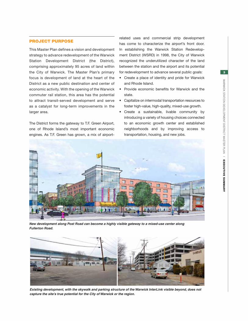
project purpoSe
This Master Plan defines a vision and development
strategy to advance redevelopment of the Warwick
Station Development District (the District),
comprising approximately 95 acres of land within
the City of Warwick. The Master Plan’s primary
focus is development of land at the heart of the
District as a new public destination and center of
economic activity. With the opening of the Warwick
commuter rail station, this area has the potential
to attract transit-served development and serve
as a catalyst for long-term improvements in the
larger area.
The District forms the gateway to T.F. Green Airport,
one of Rhode Island’s most important economic
engines. As T.F. Green has grown, a mix of airport-
New development along Post Road can become a highly visible gateway to a mixed-use center along Fullerton Road.
Existing development, with the skywalk and parking structure of the Warwick InterLink visible beyond, does not capture the site’s true potential for the City of Warwick or the region.
related uses and commercial strip development
has come to characterize the airport’s front door.
In establishing the Warwick Station Redevelop-
ment District (WSRD) in 1998, the City of Warwick
recognized the underutilized character of the land
between the station and the airport and its potential
for redevelopment to advance several public goals:
• Createaplaceof identityandprideforWarwick
and Rhode Island.
• Provide economic benefits for Warwick and the
state.
• Capitalizeonintermodaltransportationresourcesto
foster high-value, high-quality, mixed-use growth.
• Create a sustainable, livable community by
introducing a variety of housing choices connected
to an economic growth center and established
neighborhoods and by improving access to
transportation, housing, and new jobs.

4
Wa
rW
ick
sta
tio
n d
ev
el
oP
Me
nt
dis
tr
ict
Ma
st
er
Pl
an
|
eX
ec
ut
ive
Su
mm
ar
y
This plan is intended to capture broadly the goals and aspirations of the City of Warwick in a clear vision and to present a series of recommendations and design guidelines that can help it achieve that vision. While the physical plan embodies specific urban design attitudes
toward configuration of future development, its relationship to streets, open space, and transporta-tion, the plan preserves great flexibility for specific uses on each parcel. While the market and
individual development opportunities will shape the way the district evolves, the Warwick Station De-velopment Plan should provide the framework within which that growth occurs.
Mixed-use development can help support attractive and vibrant public spaces.
Master Plan context
USING THE MASTER PLAN
AIRPoRT CoNNECToR
INTERSTA
TE 95
JE
FFE
RS
oN
BLv
D.
Po
ST R
oA
D
RA
IL C
oR
RID
oR
KILvERT ST.
KILvERT ST.
FULLERToN RD.MoNTEBELLo RD.
IME
RA
Av
E.
Co
Ro
NAD
o RD.
Po
ST R
D.
INTERLINK
RAIL/BUS STATIoN
HILLSGRovENoRTH
METRoCENTER INTERMoDAL
DISTRICT
GATEWAyDISTRICT
NoRTH
GATEWAyDISTRICT
SoUTH
REDEvELoPMENT DISTRICT
T.F. GREENAIRPoRT
N
5
Wa
rW
ick
sta
tio
n d
ev
el
oP
Me
nt
dis
tr
ict
Ma
st
er
Pl
an
|
eX
ec
ut
ive
Su
mm
ar
y
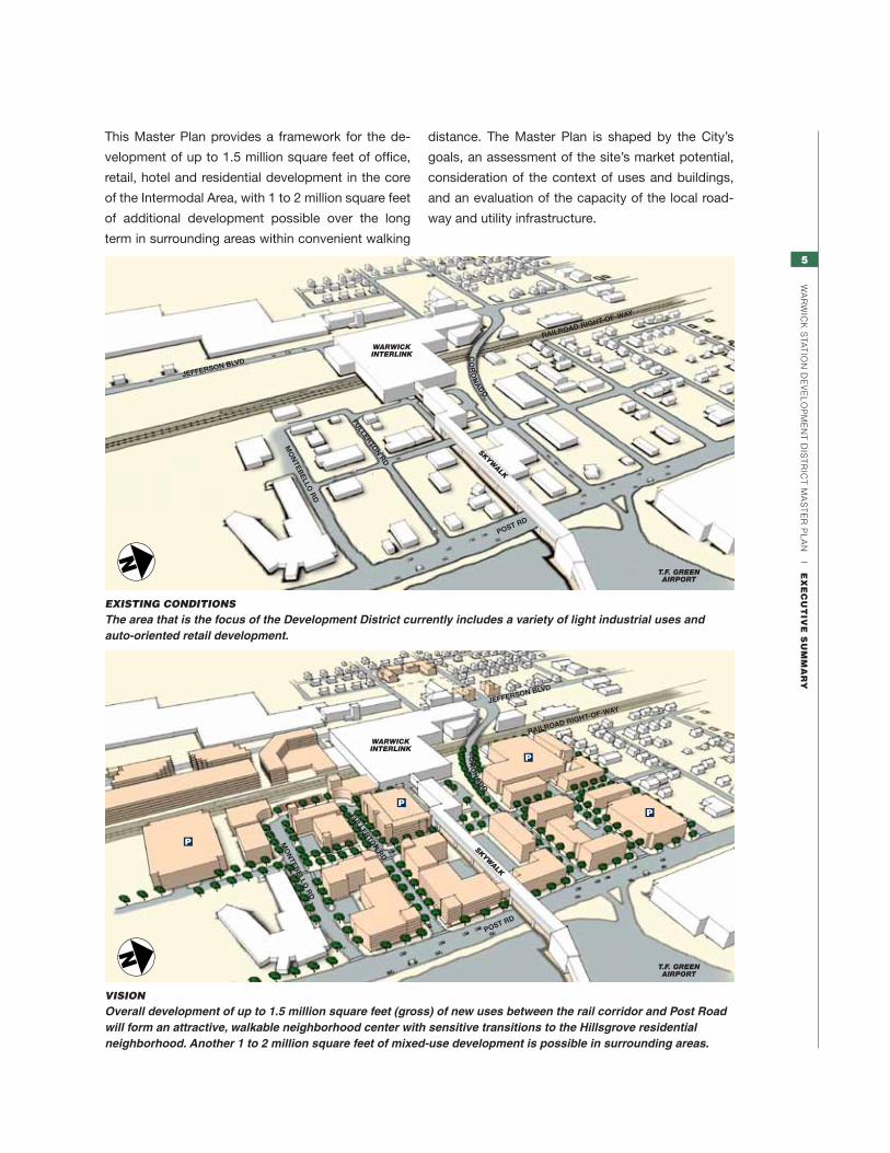
This Master Plan provides a framework for the de-
velopment of up to 1.5 million square feet of office,
retail, hotel and residential development in the core
of the Intermodal Area, with 1 to 2 million square feet
of additional development possible over the long
term in surrounding areas within convenient walking
distance. The Master Plan is shaped by the City’s
goals, an assessment of the site’s market potential,
consideration of the context of uses and buildings,
and an evaluation of the capacity of the local road-
way and utility infrastructure.
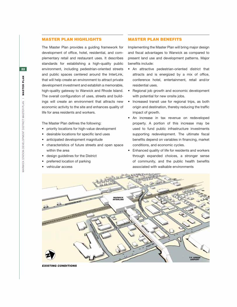
Existing Conditions
The area that is the focus of the Development District currently includes a variety of light industrial uses and auto-oriented retail development.
N
JEFFERSON BLVD
RAILROAD RIGHT-OF-WAY
POST RD
MO
NTEB
ELLO R
D
FULLERTON RD
SKYWALK
CO
RO
NA
DO
WARWICKInteRLInK
t.F. GReen AIRPORt
Vision
Overall development of up to 1.5 million square feet (gross) of new uses between the rail corridor and Post Road will form an attractive, walkable neighborhood center with sensitive transitions to the Hillsgrove residential neighborhood. Another 1 to 2 million square feet of mixed-use development is possible in surrounding areas.
N
JEFFERSON BLVD
RAILROAD RIGHT-OF-WAY
POST RD
MO
NTEB
ELLO R
D
FULLERTON RD
SKYWALK
CO
RO
NA
DO
WARWICKInteRLInK
t.F. GReen AIRPORt
6
Wa
rW
ick
sta
tio
n d
ev
el
oP
Me
nt
dis
tr
ict
Ma
st
er
Pl
an
|
eX
ec
ut
ive
Su
mm
ar
y
development approachThe level of development in the Intermodal District
has some flexibility, subject to specific location and
threshold recommendations. One controlling factor
will be the approach to parking, with structured-
parking scenarios yielding much larger development
capacity within the District. In order to achieve the
optimal build-out of the District, this Master Plan
recommends encouraging a coordinated approach
to site development and parking through land use
and economic development policy tools. If the Dis-
trict is able to follow this approach, recommended
development magnitude for the Intermodal District
core would be approximately 1.5 million gross
square feet (gsf), using 75–90% structured parking
and some sharing of parking spaces with different
peak-demand times.
An additional 1 million to 2 million gsf of new de-
velopment is possible along Jefferson Boulevard
between the Airport Connector and Coronado Road,
within the Intermodal District and in additional area
recommended for inclusion within the District. This
yields a total development opportunity of about 2.5
to 3.5 million gsf.
A second development scenario features indepen-
dent redevelopment of individual parcels, with each
parcel providing its own surface parking.
Recommended minimum redevelopment magnitude
is approximately 500,000 gsf for the individual-parcel
development approach. The master plan illustrates
development opportunity for both these scenarios.
The two scenarios share similar assumptions about
architectural and urban design objectives. Both
seek to create a pedestrian-friendly area with active
ground-floor uses, safe and attractive streetscapes,
and building massing and site design that support
a well-scaled and well-defined public realm. Due to
parking capacity needs and the need to approach
development on a parcel-by-parcel basis, the
lower-density alternative would typically consist of
commercial buildings 2 to 3 stories tall and residential
buildings as much as 5 to 6 stories tall. These building
heights fall within the existing zoning maximum of
75’. The districtwide coordinated alternative would
typically consist of commercial buildings that
average 4 to 5 stories tall and residential buildings
5 to 6 stories tall. Actual build-out may vary, and
additional height in some locations, such as corners,
may be desirable but should maintain the principles
and goals outlined in the Framework Plan and other
portions of the plan.

7
Wa
rW
ick
sta
tio
n d
ev
el
oP
Me
nt
dis
tr
ict
Ma
st
er
Pl
an
|
pl
an
nin
G a
nd
Sit
e c
on
te
Xt
Planning and SitE contExt

8
Wa
rW
ick
sta
tio
n d
ev
el
oP
Me
nt
dis
tr
ict
Ma
st
er
Pl
an
|
pl
an
nin
G a
nd
Sit
e c
on
te
Xt
9
Wa
rW
ick
sta
tio
n d
ev
el
oP
Me
nt
dis
tr
ict
Ma
st
er
Pl
an
|
pl
an
nin
G a
nd
Sit
e c
on
te
Xt
The Warwick Station Redevelopment District Master
Plan completed in 1998 by the Warwick Planning
Department, in cooperation with a group of state and
federal agencies, identified the strategic potential
of creating a rail station in Warwick to serve T.F.
Green Airport and the larger Warwick community,
in turn fostering new high-value development in the
surrounding area. To help achieve this potential, the
City established the Warwick Station Redevelopment
District boundary, over which it has jurisdiction.
After establishing the District boundary, the City of
Warwick created the Warwick Station Redevelopment
Agency (WRSA) to review and accept or reject all
development proposals. More recently, the City
elected to shift this redevelopment authority to the
Planning Board and City Council.
to Portland, ME
to Philadelphia,Baltimore, Washington
•
•
•
•
••
•
•
•
••
Springfield
Worcester
Boston
Hartford
NewYork
Bridgeport
New Haven
Providence
Fall River
New Bedford
WesterlyNew London •
MANCHESTER
LOGAN
TF GREEN
BRADLEY
NEWARK
LAGUARDIA
JFK
ISLIP
91
95
90
84
95
495
195
93
Amtrak Acela Regional service
Commuter Rail serviceProposed Commuter Rail service
Major highway
Major airport
District location
Massachusetts
RhodeIsland
New York
Connecticut
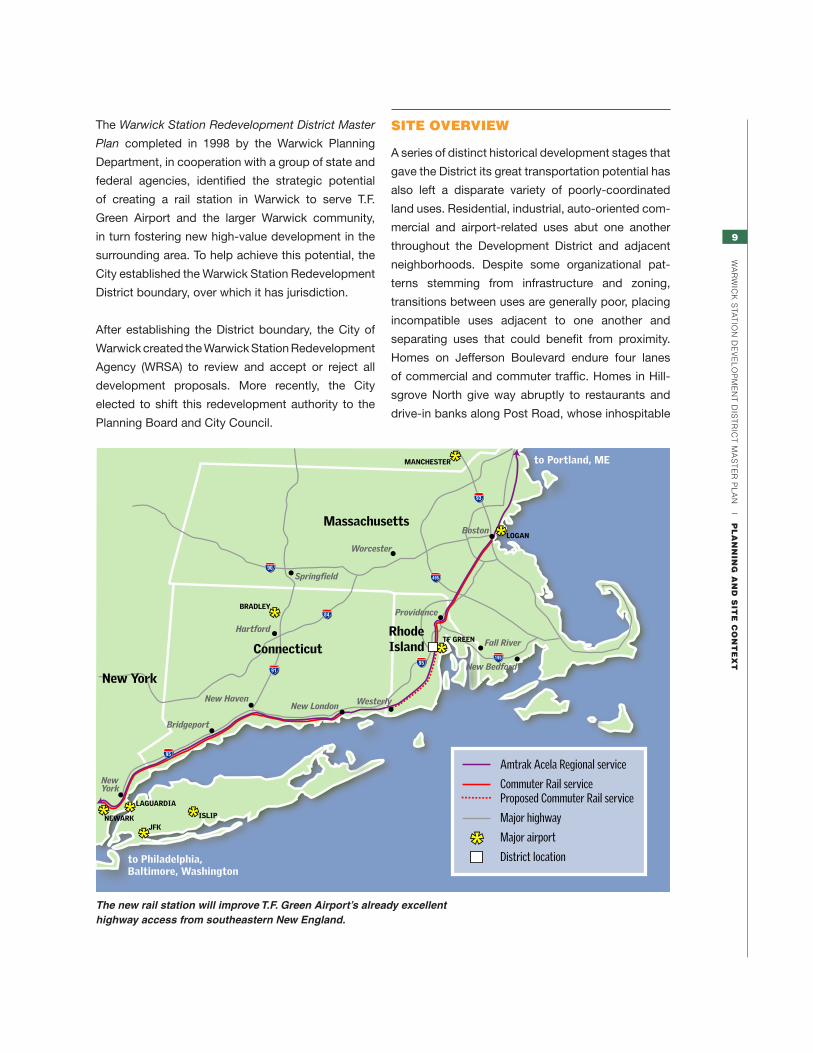
The new rail station will improve T.F. Green Airport’s already excellent highway access from southeastern New England.
Site overvieW
A series of distinct historical development stages that
gave the District its great transportation potential has
also left a disparate variety of poorly-coordinated
land uses. Residential, industrial, auto-oriented com-
mercial and airport-related uses abut one another
throughout the Development District and adjacent
neighborhoods. Despite some organizational pat-
terns stemming from infrastructure and zoning,
transitions between uses are generally poor, placing
incompatible uses adjacent to one another and
separating uses that could benefit from proximity.
Homes on Jefferson Boulevard endure four lanes
of commercial and commuter traffic. Homes in Hill-
sgrove North give way abruptly to restaurants and
drive-in banks along Post Road, whose inhospitable
10
Wa
rW
ick
sta
tio
n d
ev
el
oP
Me
nt
dis
tr
ict
Ma
st
er
Pl
an
|
pl
an
nin
G a
nd
Sit
e c
on
te
Xt
forging good relationships with these existing uses.
The following sections describe a short history of
the existing conditions to provide a basis for recom-
mended Master Plan improvements.
pedestrian environment makes these services harder
for residents to get to. The successful transforma-
tion of the Development District into a mixed-use,
pedestrian-friendly, transit-oriented area will require
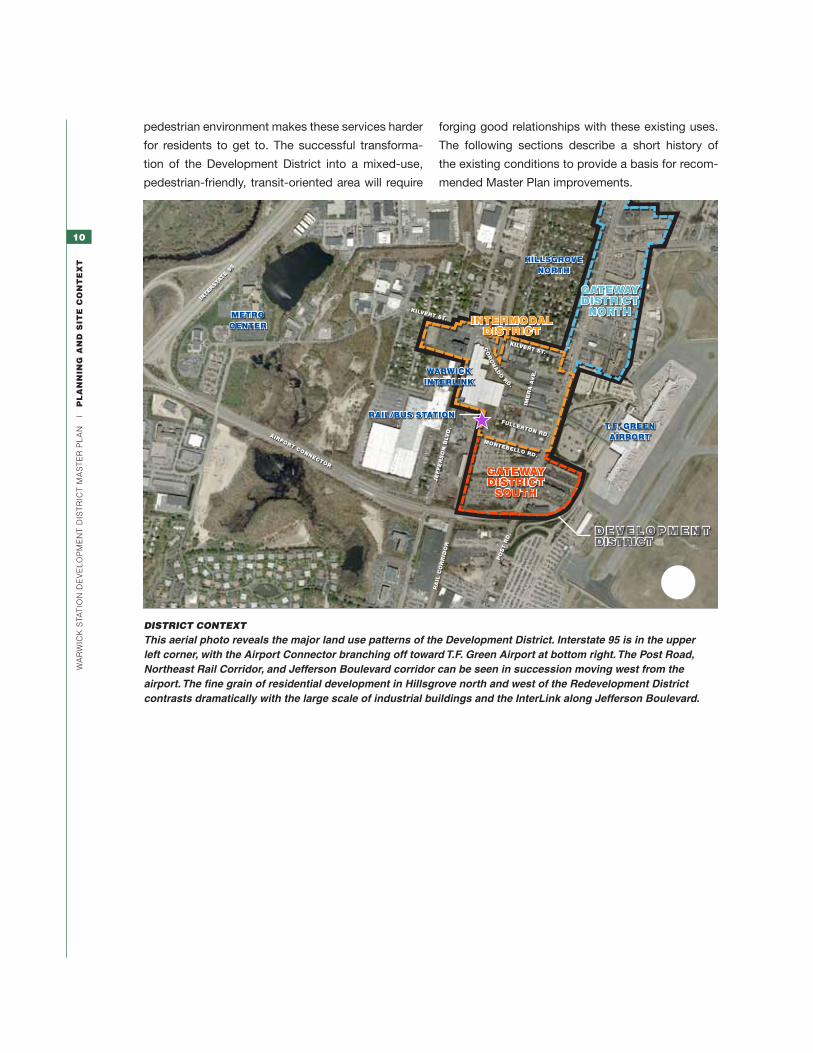
distriCt ContExt
This aerial photo reveals the major land use patterns of the Development District. Interstate 95 is in the upper left corner, with the Airport Connector branching off toward T.F. Green Airport at bottom right. The Post Road, Northeast Rail Corridor, and Jefferson Boulevard corridor can be seen in succession moving west from the airport. The fine grain of residential development in Hillsgrove north and west of the Redevelopment District contrasts dramatically with the large scale of industrial buildings and the InterLink along Jefferson Boulevard.
AIRPoRT CoNNECToR
INTERSTA
TE 95
JE
FFE
RS
oN
BLv
D.
RA
IL C
oR
RID
oR
KILvERT ST.
KILvERT ST.
FULLERToN RD.MoNTEBELLo RD.
IME
RA
Av
E.
Co
Ro
NAD
o RD.
Po
ST R
D.
WARWICKINTERLINK
RAIL/BUS STATIoN
HILLSGRovENoRTH
METRoCENTER INTERMoDAL
DISTRICT
GATEWAyDISTRICT
NoRTH
GATEWAyDISTRICT
SoUTH
D E v E L o P M E N T DISTRICT
T.F. GREENAIRPoRT
N

11
Wa
rW
ick
sta
tio
n d
ev
el
oP
Me
nt
dis
tr
ict
Ma
st
er
Pl
an
|
pl
an
nin
G a
nd
Sit
e c
on
te
Xt
Site definition
The Warwick Station Development District encom-
passes more than 95 acres of land in Warwick’s
Hillsgrove neighborhood, around T.F. Green Airport
and the Northeast Corridor rail right-of-way. The
Development District includes three subsidiary areas
as defined in the Warwick Zoning Ordinance:
1. The Intermodal District contains approximately
37 acres immediately adjacent to the airport
and Warwick InterLink. The Intermodal District
includes most of the area east of the rail corridor
bounded by Post Road on the east, Montebello
Road on the south, and Kilvert Street on the
north. It also includes land west of the rail corridor
on all four corners of the intersection of Jefferson
Boulevard, Kilvert Street and Coronado Road.
The recommendations and Design Guidelines
included in this report focus particular attention
on the Intermodal District as the most suitable
area for mixed-use development within walking
sitE ContExt: AEriAl Photo
This closer view (rotated relative to the photo on the facing page) shows the Intermodal and Gateway Districts in greater detail. Large industrial sites, the airport and its large runway and parking areas, and mid-size hotel and commercial development along Post Road contrast with the scale of residential blocks. The Warwick InterLink and skywalk link to T.F. Green bisect the Intermodal Area.
JEFFERSoN BoULEvARD
To INTERSTATE 95
WARWICKINTERLINK
I N T E R M o D A L DISTRICT
GATEWAy DISTRICT
SoUTH
GATEWAy DISTRICT
NoRTH
T.F. GREEN AIRPoRT
PoST RoAD
SK
YW
ALK
IMERA AvENUE
KIL
vE
RT
ST
RE
ET
KIL
vE
RT
ST
RE
ET
TH
UN
DE
R S
TR
EE
T
AIR
Po
RT
Co
NN
EC
To
R
Mo
NT
EB
EL
Lo
Ro
AD
FU
LL
ER
To
N R
oA
D
Co
Ro
NA
Do
Ro
AD
N
INTERMoDAL CoRE AREA
RAILROAd RIGht-OF-WAY
RAIL PLAtFORm
RECoMMENDED ExPANSIoN oFINTERMoDAL DISTRICT
12
Wa
rW
ick
sta
tio
n d
ev
el
oP
Me
nt
dis
tr
ict
Ma
st
er
Pl
an
|
pl
an
nin
G a
nd
Sit
e c
on
te
Xt
distance of the rail station and InterLink. This
plan recommends that the City expand the
Intermodal District to include property on both
sides of Jefferson Boulevard between InterLink
and the Airport Connector, to include sites
with important redevelopment potential within
walking distance of the rail station and InterLink.
Program, design, access infrastructure, and
identity of redevelopment in this area should
be coordinated with other Intermodal District
redevelopment to optimize the potential of
the whole area. In addition, an approved
redevelopment proposal for the portion of this
area east of Jefferson, submitted by owner
D’Ambra Industries, incorporates a density, mix
of uses, and internal connection to InterLink that
are fully consistent with the goals of this master
plan.
2. Gateway District South, covering about 24
acres, is one of two gateway districts intended as
transitional areas between the Intermodal District
and surrounding portions of Warwick. Gateway
District South borders the Intermodal District
along Montebello Road, is bounded on the west
by the railroad, and extends south and east as
far as the Airport Connector. In the long term,
Gateway District South has potential to support
expansion of the dense redevelopment in the
Intermodal Core Area.
3. Gateway District North is the second transi-
tional Gateway District and includes commercial
parcels immediately east and west of Post Road
from Alhambra Road and Kilvert Street north to
Airport Road, covering about 34.3 acres.
The Master Plan refers to existing residential blocks
around the Development District as Hillsgrove. In
particular, the area north of Coronado Road and east
of the railroad is referred to as Hillsgrove North, as dis-
tinct from the residential blocks known as Hillsgrove
South (in Gateway District South) that were sold for
commercial redevelopment in the late 1990s.
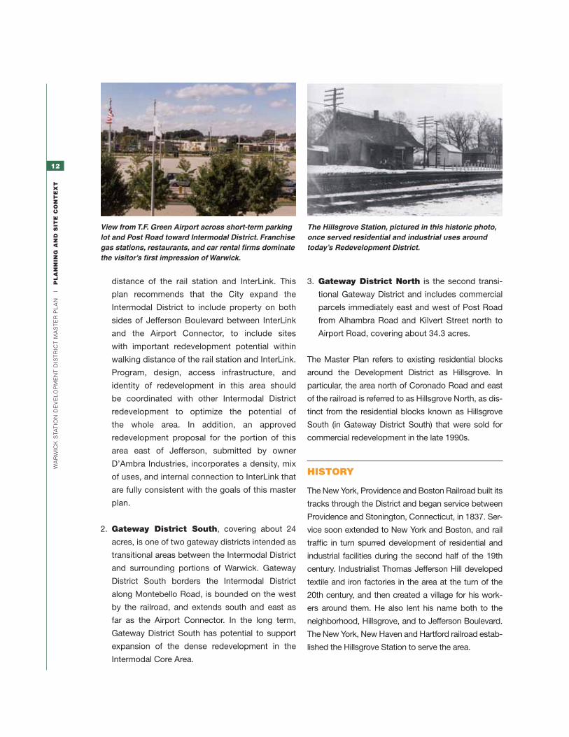
hiStory
The New York, Providence and Boston Railroad built its
tracks through the District and began service between
Providence and Stonington, Connecticut, in 1837. Ser-
vice soon extended to New York and Boston, and rail
traffic in turn spurred development of residential and
industrial facilities during the second half of the 19th
century. Industrialist Thomas Jefferson Hill developed
textile and iron factories in the area at the turn of the
20th century, and then created a village for his work-
ers around them. He also lent his name both to the
neighborhood, Hillsgrove, and to Jefferson Boulevard.
The New York, New Haven and Hartford railroad estab-
lished the Hillsgrove Station to serve the area.
View from T.F. Green Airport across short-term parking lot and Post Road toward Intermodal District. Franchise gas stations, restaurants, and car rental firms dominate the visitor’s first impression of Warwick.
The Hillsgrove Station, pictured in this historic photo, once served residential and industrial uses around today’s Redevelopment District.
13
Wa
rW
ick
sta
tio
n d
ev
el
oP
Me
nt
dis
tr
ict
Ma
st
er
Pl
an
|
pl
an
nin
G a
nd
Sit
e c
on
te
Xt
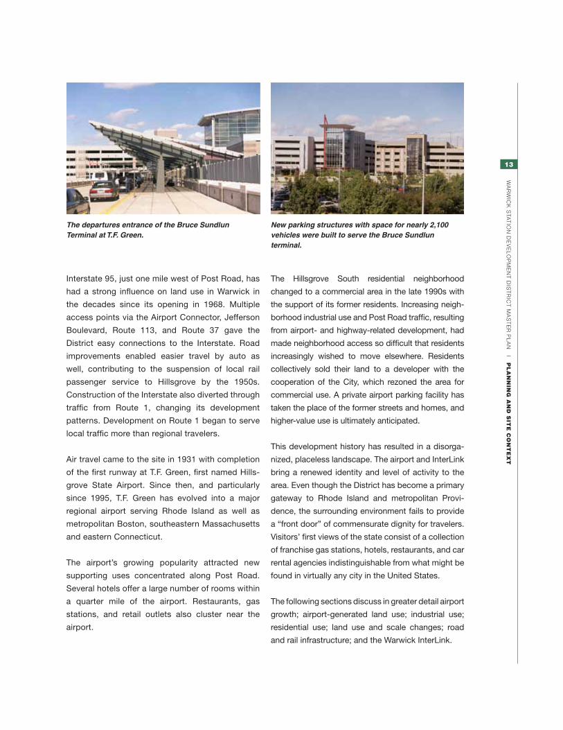
Interstate 95, just one mile west of Post Road, has
had a strong influence on land use in Warwick in
the decades since its opening in 1968. Multiple
access points via the Airport Connector, Jefferson
Boulevard, Route 113, and Route 37 gave the
District easy connections to the Interstate. Road
improvements enabled easier travel by auto as
well, contributing to the suspension of local rail
passenger service to Hillsgrove by the 1950s.
Construction of the Interstate also diverted through
traffic from Route 1, changing its development
patterns. Development on Route 1 began to serve
local traffic more than regional travelers.
Air travel came to the site in 1931 with completion
of the first runway at T.F. Green, first named Hills-
grove State Airport. Since then, and particularly
since 1995, T.F. Green has evolved into a major
regional airport serving Rhode Island as well as
metropolitan Boston, southeastern Massachusetts
and eastern Connecticut.
The airport’s growing popularity attracted new
supporting uses concentrated along Post Road.
Several hotels offer a large number of rooms within
a quarter mile of the airport. Restaurants, gas
stations, and retail outlets also cluster near the
airport.
The Hillsgrove South residential neighborhood
changed to a commercial area in the late 1990s with
the support of its former residents. Increasing neigh-
borhood industrial use and Post Road traffic, resulting
from airport- and highway-related development, had
made neighborhood access so difficult that residents
increasingly wished to move elsewhere. Residents
collectively sold their land to a developer with the
cooperation of the City, which rezoned the area for
commercial use. A private airport parking facility has
taken the place of the former streets and homes, and
higher-value use is ultimately anticipated.
This development history has resulted in a disorga-
nized, placeless landscape. The airport and InterLink
bring a renewed identity and level of activity to the
area. Even though the District has become a primary
gateway to Rhode Island and metropolitan Provi-
dence, the surrounding environment fails to provide
a “front door” of commensurate dignity for travelers.
Visitors’ first views of the state consist of a collection
of franchise gas stations, hotels, restaurants, and car
rental agencies indistinguishable from what might be
found in virtually any city in the United States.
The following sections discuss in greater detail airport
growth; airport-generated land use; industrial use;
residential use; land use and scale changes; road
and rail infrastructure; and the Warwick InterLink.
The departures entrance of the Bruce Sundlun Terminal at T.F. Green.
New parking structures with space for nearly 2,100 vehicles were built to serve the Bruce Sundlun terminal.

14
Wa
rW
ick
sta
tio
n d
ev
el
oP
Me
nt
dis
tr
ict
Ma
st
er
Pl
an
|
pl
an
nin
G a
nd
Sit
e c
on
te
Xt
successful in the area, serving both the Providence-
area market and business travel associated with
the airport. The car rental facilities that occupied a
large portion of land within the Intermodal District
are now consolidated within the Warwick InterLink.
induStrial uSe
Industrial activities have dominated the Hillsgrove area
since its initial development by Thomas Jefferson Hill.
Leviton’s Elizabeth Mill Building is the most prominent
evidence of this manufacturing heritage, its historic
tower an important local landmark visible from the
airport. Its sprawling
single-story rear addition
is more typical of modern
industrial buildings. The
Elizabeth Mill should
be preserved both for
it significance as a
historic and memorable
landmark for the area,
and for its potential
to be reoccupied with
housing, offices, or other
uses the complement the intended mix of uses in the
Intermodal District. The remainder of the Leviton site
represents one of the most significant opportunities
for new high-value, walkable, mixed-use development
that takes advantage of the district’s excellent access
options. Redevelopment there should be based
around new streets that provide inviting pedestrian
airport GroWth
T.F. Green Airport has evolved over the past 30
years into a major regional airport, spurring as-
sociated local growth and supportive uses along
the Post Road corridor—particularly hotels, car
rental facilities, and restaurants—as well as regional
economic development. With improved air service
and access, the airport no longer serves just the
Providence region, but Greater Boston as well,
becoming an attractive alternative to Boston’s
Logan Airport. Significant infrastructure improve-
ments have been made with the construction of the
Warwick InterLink, which provides a direct physical
connection to the airport terminal and houses 1,800
parking spaces for rental car operators, 800 spaces
for commuter parking, and new rail service.
In an effort to improve airport efficiency and safety and
to expand T.F. Green’s use, plans have been drawn up
to lengthen the primary runways and erect additional
buildings to support operations. Impacts on natural
resources, existing businesses and homes, and
roadway configuration are all being investigated and
reviewed in public forums.
airport-Generated land uSe
The success of
T.F. Green has
encouraged a
range of uses
to locate in
the immediate
area, including
stores, hotels,
and car rental
b u s i n e s s e s .
Conventional
auto-oriented
retail development lines both sides of Post Road
north and south of the airport in the Intermodal and
Gateway districts. Development includes a number
of service stations and restaurants, as well as banks,
hotels, and small businesses. Hotels have been
The airport’s success has encouraged the development of hotels and conference facilities.
One-story industrial buildings sit immediately adjacent to the InterLink’s skywalk.
Historic Elizabeth Mill

15
Wa
rW
ick
sta
tio
n d
ev
el
oP
Me
nt
dis
tr
ict
Ma
st
er
Pl
an
|
pl
an
nin
G a
nd
Sit
e c
on
te
Xt
connections to the InterLink and adjacent residential
streets, and attractive addresses for mixed-use
transit-oriented development. The D’Ambra asphalt
plant, located between Jefferson Boulevard and the
railroad, is subject to replacement by an approved
mixed-use development proposal, as described
above. Distribution centers for Federal Express and
UPS are among other major industrial uses near the
development district.
reSidential uSe
The residential blocks of Hillsgrove directly north and
west of the Intermodal District form an important part
of the redevelopment planning context.
Over the past century, industrial development in the
area has both sustained the residential neighborhood
economically and eroded it physically. Heavy traf-
fic on the Airport Connector, Post Road, Jefferson
Boulevard, the railroad, and commercial development
on all sides have worsened living conditions on some
parcels. Most dramatically, the 23 homeowners of
Hillsgrove South, a small pocket of blocks isolated
by the Airport Connector between Post Road and
the railroad, collectively sold their neighborhood to a
commercial developer in the late 1990s as noise and
difficult traffic access made that area increasingly
unsuitable for housing. The City supported the home-
owners’ decision, and the area, now occupied by a
private airport parking facility, represents a valuable
future growth opportunity for the Intermodal District.
The remaining residential areas in Hillsgrove North
and west of Jefferson Boulevard, however, remain
good places to live and should be further protected
and enhanced through adjacent redevelopment.
Just as factories and the original rail station formed
the initial anchor for residential development, a new
cluster of office, retail, hotel and housing development
around the rail station can form a walkable center that
serves the surrounding neighborhoods. Convenient
pedestrian connections and architecture that makes
a careful transition in scale between existing housing
Residential meets the strip: Kilvert Street looking toward Post Road.
and new development will be essential to melding the
commercial and residential areas of Hillsgrove into a
cohesive neighborhood.
New housing in the District should include a wide
spectrum of unit types, sizes, and prices in order to
serve today’s diverse housing market and to offer
people more housing choices for the different stages of
their lives than are available in nearby neighborhoods
today. Locating new housing within a convenient walk
of transit will also help households economically by
reducing their need to bear the added costs of auto-
mobile ownership.
land uSe and Scale chanGeS
Inconsistency of scale and use detracts from the
appearance and identity of public streets throughout
the District. It creates awkward combinations of uses
that don’t belong together and separates others that
should be adjacent. This inconsistency compromises
quality of life for Hillsgrove residents and makes
pedestrian access among uses inconvenient at best,
encouraging further automobile use and automobile-
oriented development.
In general, existing residential areas give way abruptly
to adjacent industrial and retail areas at their edges.
In Hillsgrove North, commercial and residential uses
face each other along the section of Kilvert Street east
16
Wa
rW
ick
sta
tio
n d
ev
el
oP
Me
nt
dis
tr
ict
Ma
st
er
Pl
an
|
pl
an
nin
G a
nd
Sit
e c
on
te
Xt
of the railroad. While some commercial uses occupy
buildings of residential scale and generate modest
amounts of traffic, other uses have busy parking
lots and service drive-throughs that make poor
neighbors to homes. West of Jefferson Boulevard,
homes in Hillsgrove along Kilvert and Cottage streets
face unused industrial land. Multifamily housing or
hotels developed on this land, if designed at a scale
sensitive to the existing context, could substantially
improve the area’s residential character.
Major scale changes among buildings and landscape
elements clutter the District visually and leave streets
without spatial definition, making orientation difficult
and walking unpleasant. Today’s Intermodal Core
Area contains a diverse mix of light industrial build-
ings ranging in size from kiosks to warehouses, open
parking lots, and even a few residential structures that
have not succumbed to industrial redevelopment.
Narrow street widths, an absence of sidewalks, and
a lack of continuity from one parcel to another make
streets appear as little more than driveways. In some
cases, homes face much larger warehouses with
blank façades, such as along Alhambra Road near
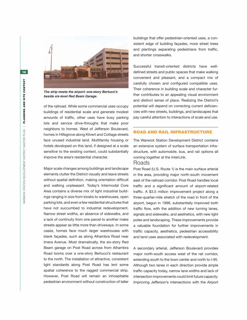
Imera Avenue. Most dramatically, the six-story Red
Beam garage on Post Road across from Alhambra
Road looms over a one-story Bertucci’s restaurant
to the north. The installation of attractive, consistent
light standards along Post Road has lent some
spatial coherence to the ragged commercial strip.
However, Post Road will remain an inhospitable
pedestrian environment without construction of taller
buildings that offer pedestrian-oriented uses, a con-
sistent edge of building façades, more street trees
and plantings separating pedestrians from traffic,
and shorter crosswalks.
Successful transit-oriented districts have well-
defined streets and public spaces that make walking
convenient and pleasant, and a compact mix of
carefully chosen and configured compatible uses.
Their coherence in building scale and character fur-
ther contributes to an appealing visual environment
and distinct sense of place. Realizing the District’s
potential will depend on correcting current deficien-
cies with new streets, buildings, and landscapes that
pay careful attention to interactions of scale and use.
road and rail infraStructure
The Warwick Station Development District contains
an extensive system of surface transportation infra-
structure, with automobile, bus, and rail options all
coming together at the InterLink.
roadsPost Road (U.S. Route 1) is the main surface arterial
in the area, providing major north-south movement
east of the railroad corridor. Post Road handles local
traffic and a significant amount of airport-related
traffic. A $3.5 million improvement project along a
three-quarter -mile stretch of the road in front of the
airport, begun in 1998, substantially improved both
traffic flow, with the addition of new turning lanes,
signals and sidewalks, and aesthetics, with new light
poles and landscaping. These improvements provide
a valuable foundation for further improvements in
traffic capacity, aesthetics, pedestrian accessibility
and land uses associated with redevelopment.
A secondary arterial, Jefferson Boulevard provides
major north-south access west of the rail corridor,
extending south to the town center and north to I-95.
Although two lanes in each direction provide ample
traffic capacity today, narrow lane widths and lack of
intersection improvements could limit future capacity.
Improving Jefferson’s intersections with the Airport
The strip meets the airport: one-story Bertucci’s beside six-level Red Beam Garage.

17
Wa
rW
ick
sta
tio
n d
ev
el
oP
Me
nt
dis
tr
ict
Ma
st
er
Pl
an
|
pl
an
nin
G a
nd
Sit
e c
on
te
Xt
Connector and Kilvert/Coronado is vital to handling
anticipated traffic increases from District redevelop-
ment. Jefferson will need an upgrade, which might
include an additional turning lane in certain locations
to support build-out and redevelopment of adjacent
properties and increased ridership of the commuter
rail. Any new turning lanes, however, should be ac-
companied by measures that maintain safe, conve-
nient pedestrian crossings at intersections.
The Airport Connector provides a valuable link to
I-95, with direct access to Jefferson Boulevard,
Post Road, and the airport. It is particularly valuable
as one of the few east-west connecting roads that
cross the railroad corridor. Intermodal District traffic
will be able to reach the Connector heading west
with minimal impact upon local traffic.
Route 37 provides another limited-access connec-
tor between the Post Road and I-95 about one mile
north of the airport. Access to Route 37 from the
Post Road should be improved to help accommo-
date redevelopment traffic and existing congestion.
Jefferson Boulevard, Post Road and smaller-scale
streets throughout the District have been designed
primarily to serve vehicles, with pedestrian accom-
modations typically limited or absent. In order to
achieve the benefits of economic development,
as well as the public health advantages and sense
of community associated with walkable places,
redevelopment actions must include a concerted
Post Road looking north in front of the airport showing new lighting, sidewalks, trees, and travel lanes.
effort to establish an inviting and safe network of
sidewalks, crosswalks, and public spaces that run
throughout the District and connect seamlessly to
adjacent neighborhoods and the area’s rail, bus, and
air transportation infrastructure.
Based on this assessment, it was determined
that the approximately 1.5 million square feet of
development anticipated within the Intermodal
Core Area could be supported by existing
roadways, with modest improvements to key site
access roadways and slip ramp improvements to
and from the airport connector. Existing roadways
can support additional development outside of the
Core Area along Jefferson Boulevard and Kilvert
Street but would require intermediate and long-term
transportation infrastructure improvements along
Jefferson Boulevard that will support the full “build
out” of the Leviton and D’Ambra properties with a
design that supports multimodal travel. Encourage
development of an access management plan for
the WSDD including exploring the feasibility of
creating another east-west connection over the
AMTRAK rail line between the district and the
airport connector.
Immediate and desirable improvements include
incorporating turning lanes at key entrances to the
development and upgrading signals and adding
pedestrian crosswalks throughout the district and
in the areas immediately adjacent to the property.
railThe rail station in the InterLink began receiving com-
muter rail service in 2011 as described below. The
Rhode Island Department of Transportation (RIDOT)
and the Massachusetts Bay Transportation Authority
(MBTA) have also studied the possibility of develop-
ing a South County Commuter Rail service to com-
munities as far south as Westerly. This service could
be very important to transit-oriented development
in the Intermodal and Gateway districts, supporting
commuting to new workplaces in the District from

18
Wa
rW
ick
sta
tio
n d
ev
el
oP
Me
nt
dis
tr
ict
Ma
st
er
Pl
an
|
pl
an
nin
G a
nd
Sit
e c
on
te
Xt
surrounding communities, and from the District’s
current and future residential development to jobs in
other communities.
Existing RIPTA bus services that connect the airport
with Kingston, Providence, and intermediate points
will serve the new rail station as well. Bus and rail
service alike will become more attractive transit
modes with the new intermodal connections.
The rail station will also serve private interstate bus
services, further enhancing intermodal connection
options.
WarWick interlink
The Warwick InterLink sits in the heart of the District.
The facility, completed in 2010, contains a new rail
station, 1,800 parking spaces for rental car opera-
tors, 800 spaces for commuters, a local and regional
bus hub, and a customer-service building with car
rental service counters. It connects directly to T.F.
Green via a 1,200-foot enclosed moving skywalk.
The facility began receiving MBTA commuter rail
service from Boston and Providence in 2011, and a
service expansion to Wickford Junction is scheduled
to begin in 2012.
A vital component of the entire Warwick Station
Development District, realization of the InterLink has
already began to have an impact on redevelopment.
The opening of a nearby Hilton Garden Inn and the
adjacent Ironworks Tavern suggest that the market
has begun to respond to the area’s great potential for
growth and success.
Immediately adjacent to the InterLink, a development
concept proposed for the D’Ambra property would
include office and hotel uses. The City of Warwick
should consider a zoning change and Comprehen-
sive Plan amendment to include this significant
property within the Intermodal District boundary.
The City of Warwick should coordinate with RIAC to
ensure that streets and other public spaces around
the facility support aspirations for the District. A
coordinated approach to landscaping, materials,
lighting, and complementary development around
the facility and its urban context can help the facility
live up to its potential as a centerpiece of the new
transit-oriented district.
Future development should respond to the views
from the elevated skywalk, which will form the first
impression of Warwick every day for many people.
Immediately west of Post Road, buildings on both
sides of the skywalk will be able to connect to the
structure. Encourage direct connections to the
Interlink from the Jefferson Boulevard corridor as
part of the D’Ambra development and with safe,
convenient crossings of Jefferson that tie to existing
and future development to the west, including
potential adaptive reuse of the Elizabeth Mill. Such
crossings should include crosswalks; a pedestrian
skywalk may also be considered if it would function
as a safe and attractive aid to pedestrians and an
asset to development.
Warwick Station will be served initially by an extension of the MBTA Boston–Providence commuter rail service. South County Commuter Rail service to other Rhode Island points, including Wickford Junction, Kingston and Westerly, is anticipated in the future.

19
Wa
rW
ick
sta
tio
n d
ev
el
oP
Me
nt
dis
tr
ict
Ma
st
er
Pl
an
|
pl
an
nin
G a
nd
Sit
e c
on
te
Xt
market opportunity
Market indicators at the time this plan was written
reflect a challenging development climate across
Rhode Island, with generally limited near-term de-
mand across a variety of commercial and residential
markets. Nevertheless, the District can attract sig-
nificant development investment over time through
strategic planning, design, marketing and other
implementation steps that nurture and highlight its
unique assets. Even in very challenging markets,
opportunities exist. Responding to them requires
identifying submarket opportunities and devising
strategies to capitalize on those opportunities.
This is the essence of product differentiation and a
market-segmentation approach.
The presence of the airport, the people-mover,
parking garage, and the proposed commuter rail
service create an opportunity to develop a transit-
oriented, walkable, mixed-use district unique in the
Northeast. Mixed-use districts increasingly draw a
variety of commercial and residential activities be-
cause they offer a whole that is greater than the sum
of its parts. They offer a sustained level of energy
throughout weekdays, weeknights and weekends; a
strong sense of identity; and efficient use of public
infrastructure that single-use environments typi-
cally lack.1 A committed long-term effort to make this
transit-oriented, walkable, mixed-use vision a reality
will enable Warwick to brand the District as an ideal
investment and location opportunity. Specifically, the
combination of multiple land uses demands close at-
tention to ensure that short-term, transaction-driven
interests don’t erode their synergy, but nurture it.
1 This translates into economic value: between 2000 and 2007, mixed-use districts saw rent growth in the 35% range, while traditional single-use office parks typically saw no real rent growth. (Chris Lienberger, Brookings Institution)
Success in advancing a product-differentiation/
market-segmentation approach for the District de-
pends on refining and applying several strategies:
• Implementing a comprehensive, flexible
transit plan to and from downtown Providence
is necessary to fully realize the District’s market
potential. Such a plan will also offer economic
benefits to downtown Providence and its hospital-
ity infrastructure
• The long-term nature of District implementation
may demand a project management structure
that could be privatized. The management plan
should (1) build organizational capacity to manage,
brand, and market the District; (2) create a land-
use regulatory and design-review process that
is managed outside Warwick’s institutionalized
subdivision and zoning process; and (3) establish a
district-management program, preferably under the
new organization and charged with the funding and
coordinating retail tenanting, landscaping, snow
removal, maintenance of public areas including
sidewalks, lighting, and signage, and trash removal
• Seekingacomplementary mix of land uses
that respond to the site’s unique assets will
make the most of its value. A survey conducted for
this plan indicated the site offers excellent location
characteristics for multifamily housing, hospitality,
and small-format offices. Pedestrian-oriented retail
would add an amenity that supports these primary
opportunities. A mix of land uses also enables new
development in the district to respond flexibly to
market opportunities as they arise.
Because the District holds development
opportunities that will likely unfold over more
than a decade, long-term focus and commitment
by organizational and political leadership is a
prerequisite for turning the vision into reality. Of
particular importance is the need to establish quickly
the land-use and design controls to protect against
near-term development that is inconsistent with the
District vision. Also of fundamental importance is
the task of creating the organizational capacity to
manage the project.

20
Wa
rW
ick
sta
tio
n d
ev
el
oP
Me
nt
dis
tr
ict
Ma
st
er
Pl
an
|
pl
an
nin
G a
nd
Sit
e c
on
te
Xt
infraStructure capacity aSSeSSment
Utility infrastructure does not appear to pose a
barrier to additional development, but it may need
significant upgrades before it can support the
proposed density of development.
Based on this assessment, it was determined
that the approximate 1.5 million square feet of
development anticipated within the Intermodal Core
Area could be supported by existing roadways,
with modest improvements at key site-access
roadways and slip ramp improvements to and
from the Airport Connector. Existing roadways can
support additional development outside of the Core
Area along Jefferson Boulevard and Kilvert Street,
but they would require transportation infrastructure
improvements along Jefferson Boulevard capable
of supporting the full “build out” of the Leviton and
D’Ambra properties with a design that supports
multimodal travel options. An access-management
plan shall be developed for the WSDD, including
exploration of the feasibility of creating another east/
west connection over the AMTRAK rail line between
the District and the Airport Connector.
Immediate and desirable improvements include
incorporating turning lanes at key entrances to
the development, upgrading signals, and adding
pedestrian crosswalks throughout the District and in
the areas immediately adjacent to the property.
coordination of development With State initiativeS
In 2002, the Governor’s Growth Planning Council
outlined a series of recommendations for the
establishment of “Growth Centers” in order to
encourage new development in “economically
and environmentally sound locations.” The goal of
defining growth centers was to assist communi-
ties in planning where new development will occur
and what it will look like, maximize the impact of
available funding resources, and remove barriers
to investment. Growth Centers are defined as
places that are “dynamic and efficient centers for
development that have a core of commercial and
community services, residential development, and
natural and built landmarks and boundaries which
provide a sense of place.” Eight distinct criteria
were established to provide the basis for evaluat-
ing whether an area could be classified as a growth
center and receive the benefits such a designation
brings. Those criteria include:
• Strengthenandencouragegrowthinexisting
centers.
• Scalenewinfrastructuretosupportcompact
growth.
• Includemixeduses.
• Createarangeofhousingopportunitiesand
choices.
• Protectandenhancecriticalenvironmental
resources.
• Provideavarietyoftransportationchoices.
• Promotecommunitydesignthatcontributestoa
sense of place.
• Encouragegrowthinappropriatelyscaled
centers.
The Warwick Station Development District meets or
exceeds all the criteria for designation as a growth
center. This Master Plan recommends that the City
of Warwick take necessary regulatory steps to have
the District officially classified as such. Additional
discussion of growth center designation appears in
the Implementation Chapter.
The City of Warwick will continue to coordinate with
the Rhode Island Airport Corporation (RIAC) and the
Rhode Island Department of Transportation (RIDOT),
and the Rhode Island Economic Development Cor-
poration (RIEDC) as redevelopment opportunities in
the District move forward.

21
Wa
rW
ick
sta
tio
n d
ev
el
oP
Me
nt
dis
tr
ict
Ma
st
er
Pl
an
|
ma
St
er
pl
an
maStEr Plan
22
Wa
rW
ick
sta
tio
n d
ev
el
oP
Me
nt
dis
tr
ict
Ma
st
er
Pl
an
|
ma
St
er
pl
an
maSter plan hiGhliGhtS
The Master Plan provides a guiding framework for
development of office, hotel, residential, and com-
plementary retail and restaurant uses. It describes
standards for establishing a high-quality public
environment, including pedestrian-oriented streets
and public spaces centered around the InterLink,
that will help create an environment to attract private
development investment and establish a memorable,
high-quality gateway to Warwick and Rhode Island.
The overall configuration of uses, streets and build-
ings will create an environment that attracts new
economic activity to the site and enhances quality of
life for area residents and workers.
The Master Plan defines the following:
• prioritylocationsforhigh-valuedevelopment
• desirablelocationsforspecificlanduses
• anticipateddevelopmentmagnitude
• characteristicsof futurestreetsandopenspace
within the area
• designguidelinesfortheDistrict
• preferredlocationofparking
• vehicularaccess
maSter plan BenefitS
Implementing the Master Plan will bring major design
and fiscal advantages to Warwick as compared to
present land use and development patterns. Major
benefits include:
• An attractive pedestrian-oriented district that
attracts and is energized by a mix of office,
conference hotel, entertainment, retail and/or
residential uses.
• Regionaljobgrowthandeconomicdevelopment
with potential for new onsite jobs.
• Increased transit use for regional trips, as both
origin and destination, thereby reducing the traffic
impact of growth.
• An increase in tax revenue on redeveloped
property. A portion of this increase may be
used to fund public infrastructure investments
supporting redevelopment. The ultimate fiscal
benefits depend on variables in financing, market
conditions, and economic cycles.
• Enhancedqualityoflifeforresidentsandworkers
through expanded choices, a stronger sense
of community, and the public health benefits
associated with walkable environments
Existing Conditions
N
JEFFERSON BLVD
RAILROAD RIGHT-OF-WAY
POST RD
MO
NTEB
ELLO R
D
FULLERTON RD
SKYWALK
CO
RO
NA
DO
WARWICKInteRLInK
t.F. GReen AIRPORt

23
Wa
rW
ick
sta
tio
n d
ev
el
oP
Me
nt
dis
tr
ict
Ma
st
er
Pl
an
|
ma
St
er
pl
an
1 Build a place of identity and pride for WarWick and rhode island.
Development should create a walkable, livable,
mixed-use, and pedestrian-oriented district that
forms an attractive gateway to Rhode Island for
regional air and rail travelers and a center of activity
for Warwick. Public spaces and architecture should
call attention to the District and attest to its high quality of development. Services sought by travelers new to
the area, such as hotels, conference facilities and dining, should be centrally and intuitively located to give
them the greatest possible choice and access with little or no need for additional transportation. Existing
clashes of land use and scale that detract from the character of the area should be corrected.
2 provide economic Benefits for WarWick and the region. Development should produce substantial long-term net revenue for the City. Overall benefits from
increased tax revenues in the District and secondary benefits should exceed anticipated development
costs to the City for streetscape improvements and other public infrastructure.
3 capitalize on intermodal transportation resources to foster high-value and high-quality mixed-use groWth. Development should take specific advantage of the Redevelopment District’s unique combination of air,
rail and highway infrastructure to capture market potential and gain a distinct place identity. A mix of uses
should be included to capitalize on the site’s accessibility to both regional and local transportation and to
make it both a destination and an origin point for travel.
4 create a sustainaBle, livaBle community. Offer households and workers choices that enhance quality of life: a variety of housing options serving all
income ranges and lifestyles; diverse employment options; transportation alternatives to the automobile that
are convenient, economical, and healthy; an expanded range of retail and services; and access to public park
and recreation facilities. Promote environmental sustainability by including compact, high-density develop-
ment that prevents impacts on undeveloped areas; transit-oriented development that minimizes energy, land,
and funds consumed by transportation; district-scale approaches to energy use and stormwater management
that minimize net flows in and out of the District; and plantings and materials that minimize local heat gain.
viSion and planninG principleS
the visionDevelopment should meet four primary objectives to
best take advantage of the District’s great potential
for Warwick and the region.
JEFFERSON BLVD
RAILROAD RIGHT-OF-WAY
POST RD
MO
NTEB
ELLO R
D
FULLERTON RD
SKYWALK
CO
RO
NA
DO
WARWICKInteRLInK
d’AmBRA PROPeRtY
LeVItOn
t.F. GReen AIRPORt
Vision
N
24
Wa
rW
ick
sta
tio
n d
ev
el
oP
Me
nt
dis
tr
ict
Ma
st
er
Pl
an
|
ma
St
er
pl
an
Planning PrinciplesThe following six planning principles represent the
key redevelopment strategies that will most effec-
tively achieve the three objectives in the Vision.
1. Create Transit-oriented Development.
Development should be carried out as a transit-
oriented district (TOD), designed specifically to
facilitate convenient connections among all land
uses and the variety of transit modes available,
thereby reducing dependence on automobile
transportation to the maximum extent feasible.
Typical TOD characteristics include relatively high
development density that places a critical mass of
transit users near transit stops and reaches levels
of development value that help support quality
infrastructure, and a pedestrian-friendly environ-
ment to facilitate and encourage walking and
bicycling among the land uses and transit modes.
Development should engage adjacent existing
residential and commercial areas so they can also
benefit from and contribute to the TOD. Choose
and locate land uses to maintain activity in key
public areas during evening and daytime hours in
order to keep streets and pedestrian areas active,
attractive and thereby safe, and to take greater
advantage of underused parking facilities and
transit services at off-peak hours.
2. Create a flexible framework for
accommodating development.
Some flexibility in the type, location, and magnitude
of new land uses is necessary so development
can respond to future market and site opportunity.
However, as development occurs in the District,
flexibility should not be accommodated at the
cost of reducing adherence to other planning
principles or displacing higher-priority uses from
selected sites in ways that would compromise the
District’s longer-term economic potential.
3. Coordinate development magnitude with
infrastructure capacity.
Development buildout should be coordinated with
thresholds of infrastructure capacity, to generate
maximum development potential and fiscal return
for a given level of infrastructure investment. For
instance, the recommended 1.5 million-square-
foot development level tested in the Intermo-
dal Core Area represents a maximum amount of
economic return for a relatively modest public
investment in recommended street infrastructure
improvements. Strategically determine magnitude
and location of development to make the most
of available capacity and to accommodate future
improvements that may be needed to support
additional development within and around the
District, such as the possible extension of Imera
Avenue into Gateway District South.
4. Design redevelopment to have a positive
impact upon its neighbors.
Support existing uses around the District, includ-
ing residential areas, long-term goals for T.F.
Green Airport, and existing businesses that may
be relocated from the District. Minimize negative
short- and long-term development impacts on
neighbors, including traffic and noise. Design and
execute new development and infrastructure to
benefit adjacent and relocated uses as much as
possible by, for example, providing established
neighborhoods and businesses a convenient walk
to shopping and transit. Accommodate relocated
businesses in appropriate locations.
5. Leverage the presence of the InterLink.
Potential future development in the District should
fully explore and capitalize on the benefits and value
created by the InterLink. Projects should recognize
the significant physical presence of the garage
and Skywalk by carefully coordinating building
entrances and connections to vertical circulation,
and by making access from the airport terminal to
future housing, commercial space, or retail areas as
attractive, convenient, and efficient as possible.
6. Maintain dialogue among stakeholders.
A broad range of government and private stake-
holders will be directly affected by, and need to
have important input into, the development of the

25
Wa
rW
ick
sta
tio
n d
ev
el
oP
Me
nt
dis
tr
ict
Ma
st
er
Pl
an
|
ma
St
er
pl
an
District. Successful development of this complex
area will depend on engaging all stakeholders in
an ongoing discussion structured to further define
development goals; supporting strategic parcel
aggregation; developing infrastructure; review-
ing development prospects for congruence with
Master Plan goals; resolving potential conflicts;
and accomplishing other key tasks.
WalkaBle development focuS areaS
New development should support a network of invit-
ing and safe streets, seamlessly connected to each
other, to the InterLink, and to T.F. Green Airport. Such
“walkable development” will expand market interest,
maximize the benefit of the District’s transit and air-
port connections, enhance flexibility of development
over time, improve livability, and help foster a strong
sense of identity and community.
Priority areas for pedestrian-friendly ground-floor uses and design. Ground-floor uses—whether office, retail, hotel, or residential—should be accessible and visible to the sidewalk, with significant window areas and frequent entrances. Architecture should feel comfortable in scale to pedestrians. Do not expose off-street parking at street level. Provide on-street parking, street trees, and generous sidewalks.
InterLink/Skywalk pedestrian connection
N
26
Wa
rW
ick
sta
tio
n d
ev
el
oP
Me
nt
dis
tr
ict
Ma
st
er
Pl
an
|
ma
St
er
pl
an
1
/
4
-
m
i
l
e
/
5
-
m
i
n
u
t
e
w
a
l
k
1
/
4
-
m
i
l
e
/
5
-
m
i
n
u
t
e
w
a
l
k
WARWICKINTERLINK
LEVITON
I M E R A AV E .
G L E N H A M AV E .
MO
NT
EB
ELL
O R
D.
FU
L LE
RT
ON
RD
.
KI L
VE
RT
ST.
KI L
VE
RT
ST.
TH
UR
BE
R S
T.
VA
ND
ER
BI L
T R
D.
ALH
AM
BR
A R
D.
J E F F E R S O N B LV D .
C O T TA G E S T.
P O S T R O A D
INTERMODALDISTRICT
RECOMMENDED EXPANSIONOF INTERMODAL DISTRICT
T.F. GREENAIRPORT
SKYWALK
C.S.O.
GATEWAYDISTRICT
SOUTH
GATEWAYDISTRICT NORTH
COR
ONADO ROAD
P
P
P
D’AMBRA PROPERTY
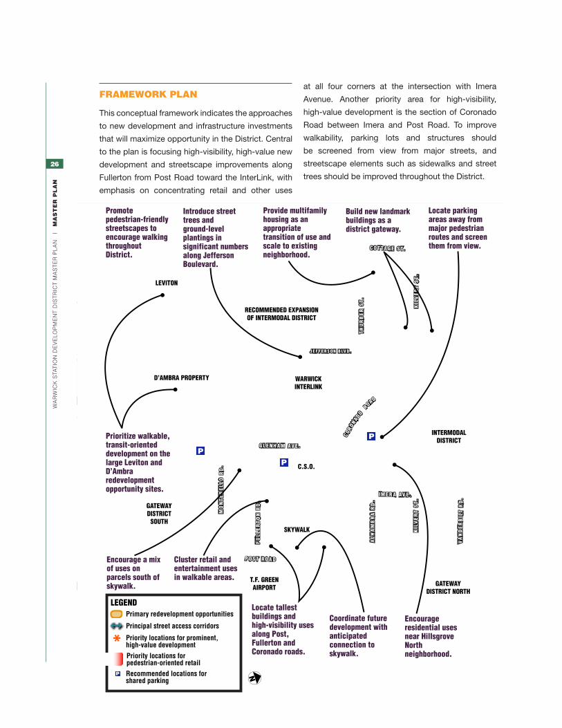
Introduce street trees and ground-level plantings in significant numbers along Jefferson Boulevard.
Promote pedestrian-friendly streetscapes to encourage walking throughout District .
Introduce street trees and ground-level plantings in significant numbers along Jefferson Boulevard.
Promote pedestrian-friendly streetscapes to encourage walking throughout District.
Encourage residential uses near Hillsgrove North neighborhood.
Locate parking areas away from major pedestrian routes and screen them from view.
Build new landmark buildings as a district gateway.
Provide multifamily housing as an appropriate transition of use and scale to existing neighborhood.
Encourage a mix of uses on parcels south of skywalk.
Coordinate future development with anticipated connection to skywalk.
Locate tallest buildings and high-visibility uses along Post, Fullerton and Coronado roads.
Cluster retail and entertainment uses in walkable areas.
Prioritize walkable, transit-oriented development on the large Leviton and D’Ambra redevelopment opportunity sites.
LEGENDPrimary redevelopment opportunities
Principal street access corridors
Recommended locations for shared parking
Priority locations for prominent,high-value development
P
Priority locations for pedestrian-oriented retail
frameWork plan
This conceptual framework indicates the approaches
to new development and infrastructure investments
that will maximize opportunity in the District. Central
to the plan is focusing high-visibility, high-value new
development and streetscape improvements along
Fullerton from Post Road toward the InterLink, with
emphasis on concentrating retail and other uses
at all four corners at the intersection with Imera
Avenue. Another priority area for high-visibility,
high-value development is the section of Coronado
Road between Imera and Post Road. To improve
walkability, parking lots and structures should
be screened from view from major streets, and
streetscape elements such as sidewalks and street
trees should be improved throughout the District.
N
27
Wa
rW
ick
sta
tio
n d
ev
el
oP
Me
nt
dis
tr
ict
Ma
st
er
Pl
an
|
ma
St
er
pl
an
development approach
two approaches to long-term developmentThis Master Plan illustrates two possible scenarios
for redevelopment within the district. The first model
promotes a district-wide approach in which co-
ordinated development of multiple parcels and
structured parking enables much higher densities of
development throughout the area. The second is an
approach in which individual parcels, as defined by
the existing street grid, are developed one by one
and fulfill all parking requirements within the bound-
aries of the parcel on surface lots.
development magnitudeThe level of development in the Intermodal District
has some flexibility, subject to specific location and
threshold recommendations. One controlling factor
will be the approach to parking, with structured-
parking scenarios yielding much larger development
capacity within the District. In order to achieve the
District’s potential, this Master Plan recommends
making every possible effort to provide a coordi-
nated approach to site development and structured
parking. If the District is able to follow this approach,
recommended development magnitude for the por-
tion of the Intermodal District east of the rail corridor
is approximately 1.5 million gross square feet (gsf),
using 75–90% structured parking and some shared
parking. Recommended minimum redevelopment
magnitude in this area is approximately 500,000
gsf for the individual-parcel development approach,
which relies on providing all parking on site in surface
lots. There is additional redevelopment opportunity
for roughly 1 to 2 million gsf in the District west of the
rail corridor, for a total range of 2.5 to 3.5 million gsf.
sample build-outThe sample development scenarios on the following
pages share similar assumptions about architectural
and urban design objectives. Both seek to create
a pedestrian-friendly area with active ground-floor
uses, safe and attractive streetscapes, and building
massing and site design that support a well-scaled
and well-defined public realm. Due to the need to
approach development on parcel-by-parcel basis,
providing parking for each use on its own site, the
lower-density alternative would produce commercial
buildings 2 to 3 stories tall and residential buildings
of up to 5 to 6 stories. These building heights fall
within the existing zoning maximum of 75’. The
alternative of coordinated districtwide development
would require commercial buildings that average 4
to 5 stories and residential buildings 5 to 6 stories
tall. Actual build-out may vary, and additional height
in some locations, such as corners, may be desir-
able, but it should maintain the principles and goals
outlined in the Framework Plan and other portions
of the plan.
steering development to the districtCity and state planning policy should actively
encourage appropriate new development to locate
in the District rather than outlying locations, as the
District’s marketability and success as a walkable
mixed-use setting will increase with the amount of
development it contains. The District meets state
criteria for priority “Growth Centers” (see page 43)
and should be promoted as such.
Creating a highly visible first phase of development
that feels complete in itself—such as developing both
sides of Fullerton along one or two blocks between
Post Road and the station—would be especially
valuable in demonstrating the level of opportunity
in the District and inviting further investment. This
would in turn help maximize the economic benefits
and other community benefits the district can pro-
vide to Warwick and Rhode Island.

28
Wa
rW
ick
sta
tio
n d
ev
el
oP
Me
nt
dis
tr
ict
Ma
st
er
Pl
an
|
ma
St
er
pl
an
illuStrative viSion Scenario 1 COORDInATED hIGh-vAluE REDEvElOPmEnT
Illustrative Vision Scenario 1 depicts the potential
benefit to the city if multiple sites are developed under
a coordinated model. A coordinated-development
approach can locate and mix uses and their park-
ing to optimize development value and quality and
makes most efficient use of infrastructure. Structured
parking increases parking capacity and concentrates
it, freeing other sites to accommodate significantly
more and higher-value development than they could
if required to provide parking. Introducing a mixture of
pedestrian-oriented uses into the district offers several
important advantages. It makes the district more mar-
ketable for office, retail, and housing development, as
each type benefits from the presence of the others. A
mixture of uses also provides the important benefit of
keeping the district active weekdays, evenings, and
weekends alike. Further, mixing commercial and resi-
dential activities can reduce overall parking needs by
up to one-third because it enables sharing of spaces
among uses with different peak demands—saving
valuable land and funds for other development and
infrastructure.
development magnitude: Approximately 1.5 million gsf between rail corridor and Post Road.
N
p
p
p
p
See lower view on facing page
See upper view on facing page
29
Wa
rW
ick
sta
tio
n d
ev
el
oP
Me
nt
dis
tr
ict
Ma
st
er
Pl
an
|
ma
St
er
pl
an
New development of significant scale at Fullerton and Post Road can capture high value from its visibility, and form the gateway to the active heart of the District along Fullerton.
A combination of office, residential, retail, and hotel uses will keep public spaces active throughout the day and week.

30
Wa
rW
ick
sta
tio
n d
ev
el
oP
Me
nt
dis
tr
ict
Ma
st
er
Pl
an
|
ma
St
er
pl
an
illuStrative viSion Scenario 2 InDIvIDuAl SITE REDEvElOPmEnT
Illustrative Vision Scenario 2 shows the potential
build out of the district if each block defined by the
existing street network were redeveloped indepen-
dently with all parking requirements accommodated
on-site. Key features are an emphasis on mixed-use
development south of the InterLink Skywalk between
Post Road and Glenham Avenue, with predominantly
housing located near residential Hillsgrove North.
Development and streetscape improvements along
Fullerton Road will help create a visible center of
identity and activity for the area. Developing sites in-
dividually, as described in this scenario, is less desir-
able than the coordinated high-value redevelopment
described in Vision Scenario 1. Should this approach
prevail, such individual redevelopment proposals
should, to the extent practical, comply with the vi-
sion illustrated in the coordinated approach.
N
development magnitude: Approximately 500,000 gsf between rail corridor and Post Road.

31
Wa
rW
ick
sta
tio
n d
ev
el
oP
Me
nt
dis
tr
ict
Ma
st
er
Pl
an
|
ma
St
er
pl
an
land uSe GuidelineS
A balanced mix of land uses will be an important
component of successful redevelopment of the
area. Mixed-use development will help keep the area
active and safe during evening as well as daytime
hours, help it serve a wide variety of people, and
allow development some flexibility to follow market
opportunities. It also will sustain uses that can
benefit mutually from each others’ presence, such
as hotel/conference and office, and retail that can
draw customers from among both daytime workers
and evening residents. Mixed uses further allow more
efficient use of parking infrastructure. The diagram
below shows priority locations for principal land uses.
The following principal land uses should be located where shown:
Office
Hotel
Housing may be anywhere in district
Priority locations for pedestrian-oriented retail
overall Balance of Target Uses For the Intermodal District These percentages may be altered over time to reflect changing macroeconomic and market conditions.
portion of total developed BuildinG floor area
Office 20–40%
Hotel 10–35%
Retail/Entertainment 10–20%
Housing 30–45%

32
Wa
rW
ick
sta
tio
n d
ev
el
oP
Me
nt
dis
tr
ict
Ma
st
er
Pl
an
|
ma
St
er
pl
an
open spaceThe greatest opportunity for open space within the
District lies in the creation of “complete streets” that
invite people to walk. As new development occurs
throughout the area, care should be taken to design
buildings, locate uses, and upgrade street infrastruc-
ture to support a vibrant and active streetscape.
Special material treatments for sidewalks and inter-
Mixed-use development incorporating office, hotel, or residential use above retail or other active ground-level use is encouraged throughout the Intermodal District to promote active, safe public areas and program synergies. Example from Atlanta, Georgia.
Quality street furnishings, paving materials, and landscaping can help make sidewalks and plazas valuable open spaces for workers, residents and visitors.
sections, as well as significant landscape and street
tree improvements, can help make the open space
an important part of the character of the area. The
landscape plan developed for the InterLink can serve
as a foundation for future design opportunities.
A public park or plaza is also strongly encouraged
as a focal point of activity and identity, and as an
amenity increasing the value of new development.
Locating this public space near the intersection of
Fullerton and Imera, and lining it with significant
office, housing, and/or hotel buildings with ground-
floor retail, can make the most of its potential.
officeOffice uses should be part of the overall develop-
ment mix to capitalize on the District’s transportation
assets, retail amenities, and presence of target work-
force living in and near the district, whose presence
can attract businesses. This will help generate new
jobs and revenue for Warwick. Any new office con-
struction in the District would be considered Class A
space but may offer a more competitive price point
compared to the Providence office market. Priority
sites for office development include those with good
visibility and auto access from major roadways, and
within a convenient walk of the InterLink and parking.
Office development opportunity would also benefit
33
Wa
rW
ick
sta
tio
n d
ev
el
oP
Me
nt
dis
tr
ict
Ma
st
er
Pl
an
|
ma
St
er
pl
an
Hotel development should include compact drop-off areas and support attractive, pedestrian-friendly streets, as in this example at University Park, Cambridge, Massachusetts
from being within a convenient walk of a hotel with
conference facilities, and/or retail and dining.
Strongly consider providing smaller-format office
spaces, flexible in size and potentially with shared
service facilities such as copying and printing, to
address the increasing appeal of such spaces. Build-
ings with such smaller-format office space will also
fit more easily into the smaller parcels and blocks
in this district than conventional large-floorplate,
single-user buildings. The variety of parcel sizes,
configurations, and proximity to the InterLink offers
the potential for flexibility, allowing large tenants or
multitenant buildings to occupy multiple contiguous
parcels or for smaller tenants or buildings to take
advantage of more constrained lots. Lobbies and
public entrances should face street intersections
whenever possible. Internal cafeterias are strongly
discouraged; a major part of the market appeal of
such a district is the opportunity for workers to take a
convenient walk to dining opportunities outside their
building. Retail uses and other publicly accessible
spaces should be located along the street edge of
office buildings wherever feasible to help activate the
street and adjacent outdoor spaces.
hotel/conferenceOne or more full-service hotels with conference
facilities would be highly desirable to leverage the
presence of the airport. Hotels should be primarily
oriented to business customers—avoiding luxury or
limited-service concepts—to best utilize airport
traffic and support District office development.
Frequent shuttle and/or transit service to Providence
is recommended to help District hotel development
complement the greater Providence hotel market.
Priority should be given to sites that have high vis-
ibility from Post Road and Jefferson Boulevard, and
that can offer convenient access to InterLink and
the airport via the Skywalk. Hotel/conference uses
should also be sited to provide optimal amenity value
to office uses in the District to the extent feasible.
Public entrances and ground-floor interior uses that
are publicly accessible should be oriented toward
adjacent streets to help activate the street and
adjacent outdoor spaces. These specifically include
restaurants, cafes, bars, conference spaces, and
lobbies associated with hotel use.
retail/entertainment/diningRetail, entertainment and dining uses should be
clustered in walkable areas, both to promote walk-
ability and to build market interest in office, hotel and
residential development. Retail, entertainment, and
dining should function as amenities for these other
higher-value uses, not as primary land uses them-
selves. Key target areas include Fullerton Road, cor-
ners around the intersections of Imera and Coronado,
and corners around the intersection of Jefferson and
Coronado. Indoor retail atriums should be prohibited,
as they detract from the street activity and acces-
sibility that is an objective in the Intermodal District.
Rather, all retail and entertainment uses should be
visible from adjacent streets via highly transparent
façades. Outdoor eating areas are encouraged adja-
cent to the sidewalk—especially in areas that receive
direct sun—and should be highly visible to promote
an active edge along the street. They should not be
so large, however, that they diminish the presence of
building edges that define key intersections. Service
and support uses—such as loading docks, waste
disposal areas, and mechanical equipment—from
view and locate them away from publicly accessible
34
Wa
rW
ick
sta
tio
n d
ev
el
oP
Me
nt
dis
tr
ict
Ma
st
er
Pl
an
|
ma
St
er
pl
an
within individual buildings and blocks—to expand
choices for households, promote a diverse, mixed-
income community, and maximize potential market
capture and absorption rate.
Entrances should be oriented toward the street; in
multi-unit buildings, ground-level flats or townhouses
should have individual entrances that face the street,
and they should have small front gardens around
those entrances wherever possible. Buildings should
also be designed to have welcoming lobbies and
include a range of unit types and configurations,
particularly the smaller units favored by many urban
dwellers today. Parking lots should be located away
from the streets at the side or the rear of a parcel and
have landscaped edges to screen views from streets
and residential areas. Keep the number of driveways
that connect to parking structures and surface park-
ing to a minimum.
regional sports facilitiesEncourage development of a regional sports facility
within the target mix of uses within the surrounding
area (excluding the Core District) that will be sup-
ported by the multimodal transportation options.
The design of such facility, if located along a public
street, should fully support the architectural guide-
lines, as defined in the Master Plan and Design
Manual. These facilities have been shown to provide
a source of positive direct and indirect economic
benefits from increasing tax revenues and multipliers
spaces. Do not locate parking, except for on-street
parallel parking, in front of retail entrances. Instead,
orient access to pedestrian routes that connect to
parking structures, transit, and the neighborhood
street network.
residentialMultifamily residential uses are encouraged through-
out the District. They are the only use recommended
for parcels along Kilvert flanking Imera, and Cottage
Street in order to create a proper transition to the
detached housing that exists around the site today.
Housing should include a range of unit types, sizes
and price points across the District—and preferably
Active ground-floor uses such as restaurants, as well as other retail uses and office and hotel lobbies, will make public areas of the Intermodal District energetic, attractive, and safe.
A regional sports facility should provide a pedestrian-oriented façade with significant indoor-outdoor visual connections along any public street it adjoins.
Multifamily housing, such as this example in downtown St. Paul, should incorporate a range of building forms that relate to both existing residential context and new higher-density development. A range of unit types should be provided to accommodate diverse residents.

35
Wa
rW
ick
sta
tio
n d
ev
el
oP
Me
nt
dis
tr
ict
Ma
st
er
Pl
an
|
ma
St
er
pl
an
it can serve as a safe and attractive aid to pedestrians
and asset to development—should connect the
Intermodal District and Jefferson Boulevard west.
ParkingProvide parking according to the table of parking-
generation ratios shown above, or at lower ratios
if that can meet demand. These ratios anticipate
some sharing of parking facilities among office,
retail, and entertainment uses due to different peak
hours of use. As patterns of transit use become
established, parking ratios could be lowered to re-
flect a progressive shift away from automobile use
toward transit. To help new development achieve
the efficiencies possible with shared parking, allow
associated with additional spending from increased
hotel occupancy, restaurant and retail job growth.
train PlatformThe new train platform for commuter rail service is
located within the InterLink garage on the west side
of the tracks and extends approximately 500 feet to
the south. Riders will reach the platform primarily
from the Jefferson Boulevard side of the tracks. A
staircase and elevator currently provide access from
the east side of the tracks by a pathway through the
third floor of the facility and down to the platform.
Make every effort to create inviting, convenient, and
safe walking access between the platform, develop-
ment sites east of the tracks, and the Skywalk. This
is critical to enabling good walking access between
the station and transit-oriented development in the
Intermodal Core Area. A parcel on the east side of
the tracks along Glenham Avenue has been identified
by RIDOT as a potential site for a future rail station
building. New development on the D’Ambra property
adjacent to the station platform should incorporate
walking connections linking the Jefferson Boulevard
sidewalk to the train platform and InterLink.
Access to the InterLink from the west side of
Jefferson Boulevard must be improved to support
redevelopment of the Leviton parcel and provide a
safe, walkable path to the InterLink train platform.
Safe, inviting crosswalks—and possibly a skywalk if
Portions of parking structures facing public areas should relate well to human scale, complement the character of adjacent buildings, and incorporate visually attractive elements.
Parking Generation RatiosWherever possible, parking spaces should be shared among different uses with different demand peaks. As a result, the overall parking ratio for all uses may be lower than the effective ratio for individual use types.
uSe current ZoninG maSter plan recommendation
Office Bank/medical 1 space / 200 sf GFA1 1 space / 300 sf GFA
Professional 1 space / 300 sf GFA
Hotel 1 space / bedroom 0.75 space / bedroom
Multifamily residential 2 spaces / DU2 1.5 spaces / DU
Retail/Entertainment 1 space / 200 sf GFA 1 space / 300 sf GFA
1 GFA = square feet of gross floor area2 DU = dwelling unit

36
Wa
rW
ick
sta
tio
n d
ev
el
oP
Me
nt
dis
tr
ict
Ma
st
er
Pl
an
|
ma
St
er
pl
an
Current construction costs for parking are ap-
proximately $15,000–$20,000 per space for
above-ground structures and $2,000–$3,000 per
surface-lot space.
deSiGn GuidelineS
These Design Guidelines are intended to provide
residents, property owners, business owners,
developers, and City agencies with the tools to
understand the desired physical form and character
of the Warwick Station Development District.
Who is expected to use these guidelines?Because these guidelines will be used in evaluating
new development projects in the District, the most
frequent users of this document will be the people
concerned with the development of new buildings
and public spaces.
property owners/developersThe guidelines can acquaint property owners and
developers with the issues of district character
identified in the Master Plan and can give direction
on how new development can help address rel-
evant issues and return greater value to developers
and owners.
designersThe guidelines will help architects and others who
design buildings and public spaces understand
what is expected of their products and what could
make their designs more compatible with their sur-
roundings and/or more consistent with the goals of
the Master Plan.
project neighborsPeople who live near the sites of proposed new
developments will benefit greatly from these
guidelines, as they may give neighbors a better
understanding of what they can expect from future
projects. Ultimately, the guidelines will work as a tool
parking for a given use to be located on a separate
block and up to 1,000 feet away if connected by a
safe and convenient walking route.
The decrease in required number of spaces for both
hotel and residential uses reflects the presence
of transit options in the area and the proximity of
the airport. For instance, many hotel patrons will
arrive and depart via the airport and may not need
parking during their stay in the District. The Hilton
Garden Inn has experienced high occupancy since
its opening, yet it continues to have excess parking
capacity, even though it has opened an active suc-
cessful restaurant next door.
Carefully design parking to enhance the pedestrian
experience and respect surrounding residential
neighborhoods. Locate any surface lots behind
buildings, not between building fronts and the
street. Screen parking lots with landscape features
that provide a buffer between the parking and
surrounding sites, and integrate plantings into the
parking field to break up its visual scale.
Parking structure design should contribute to the
character of adjacent streets and other public
areas. In general, recommended parking structure
sites have minimal frontage on public spaces. Any
parking structure with frontage on Fullerton, Imera,
Coronado or Post Road must include ground-level
retail, dining, or entertainment uses and follow the
façade design guidelines below. Residential or
other uses are strongly encouraged on upper floors
to screen parking. Where such upper-story uses
are not feasible, façades facing public areas should
incorporate a character and hierarchy of scale
compatible with adjacent buildings and with hu-
man scale. While the structure need not mimic the
appearance of a conventional building, materials
and composition should relate well to surrounding
architecture. Façades facing the rail corridor or ser-
vice areas may receive a lesser level of investment.
Any parking structure along Kilvert Street should be
lined with residential space on all floors.
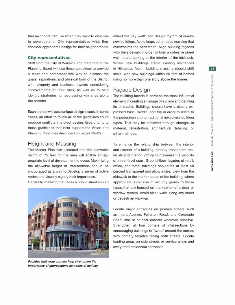
37
Wa
rW
ick
sta
tio
n d
ev
el
oP
Me
nt
dis
tr
ict
Ma
st
er
Pl
an
|
ma
St
er
pl
an
reflect the bay width and design rhythm of nearby
new buildings. Avoid large, continuous massing that
overwhelms the pedestrian. Align building façades
with the sidewalk in order to form a cohesive street
wall; locate parking at the interior of the lot/block.
Where new buildings adjoin existing residences
in Hillsgrove North, building massing should shift
scale, with new buildings within 50 feet of homes
rising no more than one story above the homes.
façade designThe building façade is perhaps the most influential
element in creating an image of a place and defining
its character. Buildings should have a clearly ex-
pressed base, middle, and top in order to relate to
the pedestrian and to traditional mixed-use building
types. This may be achieved through changes in
material, fenestration, architectural detailing, or
other methods.
To enhance the relationship between the interior
and exterior of a building, employ transparent ma-
terials and interior lighting to maximize the visibility
of street-level uses. Ground-floor façades of retail,
office, and hotel buildings should be at least 50
percent transparent and allow a clear view from the
sidewalk to the interior space of the building, where
appropriate. Limit use of security grates to those
types that are housed on the interior of a door or
window system. Avoid blank walls along any street
or pedestrian walkway.
Locate major entrances on primary streets such
as Imera Avenue, Fullerton Road, and Coronado
Road, and at or near corners wherever possible.
Strengthen all four corners of intersections by
encouraging buildings to “wrap” around the corner,
with primary façades facing both streets. Locate
loading areas on side streets or service alleys and
away from residential entrances.
Façades that wrap corners help strengthen the importance of intersections as nodes of activity.
that neighbors can use when they want to describe
to developers or City representatives what they
consider appropriate design for their neighborhood.
city representativesStaff from the City of Warwick and members of the
Planning Board will use these guidelines to provide
a clear and comprehensive way to discuss the
goals, aspirations, and physical form of the District
with property and business owners considering
improvements of their sites, as well as to help
identify strategies for addressing key sites along
the corridor.
Each project will pose unique design issues. In some
cases, an effort to follow all of the guidelines could
produce conflicts in project design. Give priority to
those guidelines that best support the Vision and
Planning Principles described on pages 23–25.
height and MassingThe Master Plan has assumed that the allowable
height of 75 feet for the area will enable an ap-
propriate level of development to occur. Maximizing
the allowable height at intersections should be
encouraged as a way to develop a series of active
nodes and visually signify their importance.
Generally, massing that faces a public street should

38
Wa
rW
ick
sta
tio
n d
ev
el
oP
Me
nt
dis
tr
ict
Ma
st
er
Pl
an
|
ma
St
er
pl
an
streetscapeBecause streets will most likely be the largest
public open space in the Development District, they
should be treated as the major component of the
public realm.
Where possible, widen sidewalks to provide areas
for enhanced landscaping, more active pedestrian-
oriented uses, and other elements that can enhance
the pedestrian experience. Sidewalk materials could
combine brick and concrete, with special paving
providing an attractive setting for activities such as
cafes and restaurants to spill out on to the sidewalk.
Walking networkCreating an extensive and inviting walking network
in the Intermodal District that is integrated well with
surrounding areas will improve access, enhance
development potential, and make a positive contri-
bution to public health. Coordinate network connec-
tions with intersections and traffic signals and make
them accessible to people with mobility limitations.
Network integration with the InterLink and the Sky-
walk is especially important to overcome the barriers
posed by the rail corridor and Post Road.
3
1
6
4
2
1 Along Fullerton Road, with active
ground-floor retail
2 Skywalk connecting to T.F. Green Airport,
InterLink, Imera Road. and potentially new
development at Post Road
3 From the Hillsgrove North neighborhood on
each side of Imera Avenue leading south
toward Fullerton Road
4 Crossing the railroad tracks via the InterLink,
with connections to Jefferson Boulevard,
Fullerton Road, Imera Avenue, and the
D’Ambra site
5 Priority pedestrian crossing connecting
the InterLink with west side of Jefferson
Boulevard to create access to the hotel,
residential neighborhoods, and potential future
redevelopment of the former Leviton site.
6 From the Interlink north and south along
Jefferson Boulevard
Priority Pedestrian Network Connections
Expanding brick areas to include the whole sidewalk helps provide definition to places where outdoor dining or other special use of the sidewalk is encouraged.
65
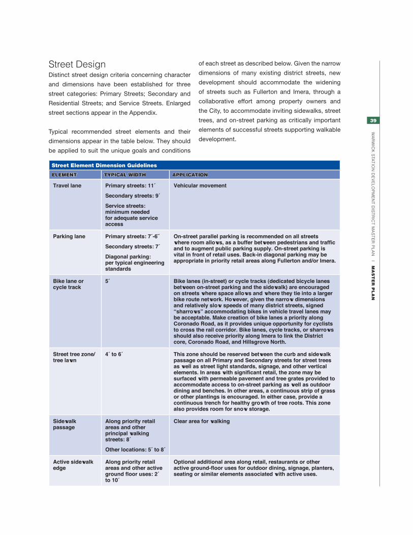
39
Wa
rW
ick
sta
tio
n d
ev
el
oP
Me
nt
dis
tr
ict
Ma
st
er
Pl
an
|
ma
St
er
pl
an
Street Element Dimension Guidelines
element typical Width application
Travel lane Primary streets: 11´
Secondary streets: 9´
Service streets: minimum needed for adequate service access
Vehicular movement
Parking lane Primary streets: 7´-6˝
Secondary streets: 7´
Diagonal parking: per typical engineering standards
On-street parallel parking is recommended on all streets where room allows, as a buffer between pedestrians and traffic and to augment public parking supply. On-street parking is vital in front of retail uses. Back-in diagonal parking may be appropriate in priority retail areas along Fullerton and/or Imera.
Bike lane or cycle track
5´ Bike lanes (in-street) or cycle tracks (dedicated bicycle lanes between on-street parking and the sidewalk) are encouraged on streets where space allows and where they tie into a larger bike route network. However, given the narrow dimensions and relatively slow speeds of many district streets, signed “sharrows” accommodating bikes in vehicle travel lanes may be acceptable. Make creation of bike lanes a priority along Coronado Road, as it provides unique opportunity for cyclists to cross the rail corridor. Bike lanes, cycle tracks, or sharrows should also receive priority along Imera to link the District core, Coronado Road, and Hillsgrove North.
Street tree zone/tree lawn
4´ to 6´ This zone should be reserved between the curb and sidewalk passage on all Primary and Secondary streets for street trees as well as street light standards, signage, and other vertical elements. In areas with significant retail, the zone may be surfaced with permeable pavement and tree grates provided to accommodate access to on-street parking as well as outdoor dining and benches. In other areas, a continuous strip of grass or other plantings is encouraged. In either case, provide a continuous trench for healthy growth of tree roots. This zone also provides room for snow storage.
Sidewalk passage
Along priority retail areas and other principal walking streets: 8´
Other locations: 5´ to 8´
Clear area for walking
Active sidewalk edge
Along priority retail areas and other active ground floor uses: 2´ to 10´
Optional additional area along retail, restaurants or other active ground-floor uses for outdoor dining, signage, planters, seating or similar elements associated with active uses.
street designDistinct street design criteria concerning character
and dimensions have been established for three
street categories: Primary Streets; Secondary and
Residential Streets; and Service Streets. Enlarged
street sections appear in the Appendix.
Typical recommended street elements and their
dimensions appear in the table below. They should
be applied to suit the unique goals and conditions
of each street as described below. Given the narrow
dimensions of many existing district streets, new
development should accommodate the widening
of streets such as Fullerton and Imera, through a
collaborative effort among property owners and
the City, to accommodate inviting sidewalks, street
trees, and on-street parking as critically important
elements of successful streets supporting walkable
development.

40
Wa
rW
ick
sta
tio
n d
ev
el
oP
Me
nt
dis
tr
ict
Ma
st
er
Pl
an
|
ma
St
er
pl
an
primary StreetsFullerton Road
Rebuild Fullerton Road as the primary vehicular and
pedestrian access to the core mixed-use area. It
should be rebuilt as a two-way, two- or three-lane
street with on-street parking on both sides of the
road. Provide two to three travel lanes and on-street
parking lanes—or possibly diagonal parking. Make
sidewalks wide enough to support Fullerton as the
prime corridor for pedestrian-oriented activity.
Imera Avenue
Rebuild Imera Avenue as a corridor for internal
movement in the Intermodal Core Area for cars, bikes
and pedestrians (see section, below). Development
should preserve the option of extending Imera south
of Montebello Road as far as the Airport Connector
to accommodate possible future redevelopment in
the former Hillsgrove South area. Sidewalks—from
Montebello Road to Hillsgrove North—should pro-
vide ample room for pedestrians, street trees, and
other activities. Imera should be rebuilt as a two-way,
two- to three-lane street with on-street parking on
both sides. A priority bicycle corridor, Imera links new
transit-oriented development with Hillsgrove North
and Coronado Road; it should include appropriate
lanes and signage.
Coronado Road
Rebuild Coronado Road as a two-way, four-lane
street with on-street parking along both sides of
the road east of Imera Avenue (see section at top
right). One or both parking lanes may change to
turning lanes at intersections as required. Include
sidewalks that provide ample room for pedestrians,
street trees, and other activities. Include bike lanes
between Jefferson Boulevard and Imera Avenue to
improve this important bicycle connection across the
rail corridor. Consider introducing a landscaped me-
dian to reduce the expanse of impervious surface,
FULLERTON ROAD1. Awning or canopy structure
2. Street trees @ 30 feet o.c.
3. Architectural element (cornice, parapet, railing, etc.)
A larger version of this diagram appears on page 54.
ImERA AvENUE1. Awning or canopy structure
2. Street trees @ 30 feet o.c.
3. Architectural element (cornice, parapet, railing, etc.)
A larger version of this diagram appears on page 55.
Street CategoriesPrimary streetSecondary streetService street

41
Wa
rW
ick
sta
tio
n d
ev
el
oP
Me
nt
dis
tr
ict
Ma
st
er
Pl
an
|
ma
St
er
pl
an
Buildings on neighboring parcels should complement one another in form and character, particularly at district gateway locations such as along Coronado Road, as in this example of recent development in Texas.
provide pedestrians with an intermediate stopping
point at crosswalks, and celebrate this block as a
key district gateway.
Secondary and residential StreetsThese include Imera Avenue north of Coronado Road,
Glenham Avenue, and Kilvert, Thurber, and Cottage
streets. Secondary and residential streets should be
two-lane, two-way roads with on-street parking on
both sides (see section, below). One or two additional
lanes may be added and parking removed on Imera
Avenue south of Alhambra Road and Kilvert Street
west of Jefferson Boulevard as necessary to ac-
commodate improvements at the intersections with
Coronado Road and Jefferson Boulevard. Provide a
landscaped tree lawn next to each curb and provide
sidewalks on both sides.
Service StreetsService streets include Fresno Road (located beneath
the InterLink and Skywalk), Montebello Road, and
Alhambra Road. Service streets may be one- or two-
lane roads, either one- or two-way, with adequate
room for service vehicles as required and optional on-
street parking. The curb-to-curb dimension should be
minimized. Loading docks and other service areas
should be located on service streets and away from
other streets oriented to pedestrians and through
vehicles. Five- to eight-foot-wide sidewalks should
line each side of the roadway.
design Guidelines for Building edgesAlong primary streets, building façades should be
located adjacent to the sidewalk or within the build-
to line. Building façades and volumes should include
a hierarchy of proportions ranging in scale from the
individual human to the overall building, as well as
variations in massing and bays to create interest
and distinction. Awnings and canopy structures are
encouraged where possible to provide shelter from
the sun, wind, and rain and to promote interchange
between interior and exterior uses at the street level.
CORONADO ROAD1. Awning or canopy structure
2. Street trees @ 30 feet o.c.
3. Architectural element (cornice, parapet, railing, etc.)
A larger version of this diagram appears on page 56.
SECONDARy AND RESIDENTIAL STREETS1. Awning or canopy structure
2. Street trees @ 30 feet o.c.
3. Architectural element (cornice, parapet, railing, etc.)
A larger version of this diagram appears on page 55.
42
Wa
rW
ick
sta
tio
n d
ev
el
oP
Me
nt
dis
tr
ict
Ma
st
er
Pl
an
|
ma
St
er
pl
an
Along secondary streets, buildings should be set
back ten feet from the sidewalks to create a front
lawn or landscaped area. Awnings and canopy
structures are encouraged at entrances to residen-
tial uses and at key building entries.
Along service streets, building façades are encour-
aged to have at least one transparent glazed window
or door every 40 feet horizontally to promote informal
surveillance. No setback requirements apply. Access
to the InterLink should be maintained via Fresno Road.
43
Wa
rW
ick
sta
tio
n d
ev
el
oP
Me
nt
dis
tr
ict
Ma
st
er
Pl
an
|
imp
le
me
nt
at
ion
imPlEmEntation

44
Wa
rW
ick
sta
tio
n d
ev
el
oP
Me
nt
dis
tr
ict
Ma
st
er
Pl
an
|
imp
le
me
nt
at
ion
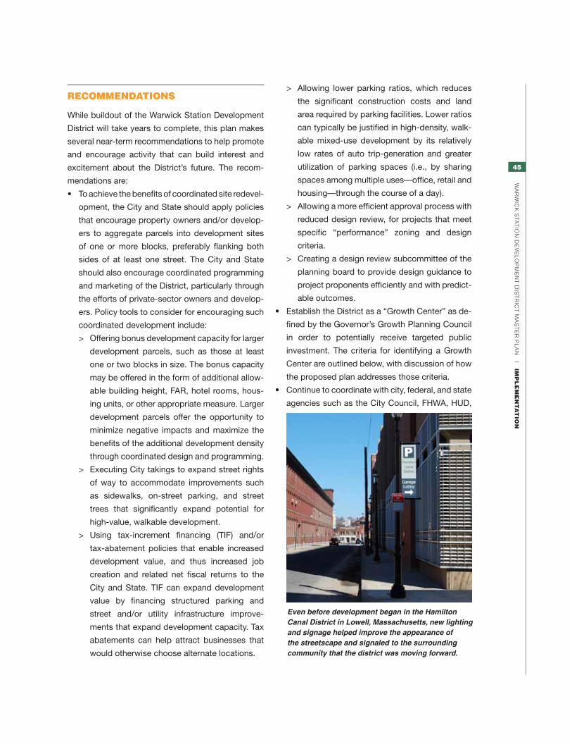
45
Wa
rW
ick
sta
tio
n d
ev
el
oP
Me
nt
dis
tr
ict
Ma
st
er
Pl
an
|
imp
le
me
nt
at
ion
recommendationS
While buildout of the Warwick Station Development
District will take years to complete, this plan makes
several near-term recommendations to help promote
and encourage activity that can build interest and
excitement about the District’s future. The recom-
mendations are:
• Toachievethebenefitsofcoordinatedsiteredevel-
opment, the City and State should apply policies
that encourage property owners and/or develop-
ers to aggregate parcels into development sites
of one or more blocks, preferably flanking both
sides of at least one street. The City and State
should also encourage coordinated programming
and marketing of the District, particularly through
the efforts of private-sector owners and develop-
ers. Policy tools to consider for encouraging such
coordinated development include:
> Offering bonus development capacity for larger
development parcels, such as those at least
one or two blocks in size. The bonus capacity
may be offered in the form of additional allow-
able building height, FAR, hotel rooms, hous-
ing units, or other appropriate measure. Larger
development parcels offer the opportunity to
minimize negative impacts and maximize the
benefits of the additional development density
through coordinated design and programming.
> Executing City takings to expand street rights
of way to accommodate improvements such
as sidewalks, on-street parking, and street
trees that significantly expand potential for
high-value, walkable development.
> Using tax-increment financing (TIF) and/or
tax-abatement policies that enable increased
development value, and thus increased job
creation and related net fiscal returns to the
City and State. TIF can expand development
value by financing structured parking and
street and/or utility infrastructure improve-
ments that expand development capacity. Tax
abatements can help attract businesses that
would otherwise choose alternate locations.
> Allowing lower parking ratios, which reduces
the significant construction costs and land
area required by parking facilities. Lower ratios
can typically be justified in high-density, walk-
able mixed-use development by its relatively
low rates of auto trip-generation and greater
utilization of parking spaces (i.e., by sharing
spaces among multiple uses—office, retail and
housing—through the course of a day).
> Allowing a more efficient approval process with
reduced design review, for projects that meet
specific “performance” zoning and design
criteria.
> Creating a design review subcommittee of the
planning board to provide design guidance to
project proponents efficiently and with predict-
able outcomes.
• EstablishtheDistrictasa“GrowthCenter”asde-
fined by the Governor’s Growth Planning Council
in order to potentially receive targeted public
investment. The criteria for identifying a Growth
Center are outlined below, with discussion of how
the proposed plan addresses those criteria.
• Continuetocoordinatewithcity,federal,andstate
agencies such as the City Council, FHWA, HUD,
Even before development began in the Hamilton Canal District in Lowell, Massachusetts, new lighting and signage helped improve the appearance of the streetscape and signaled to the surrounding community that the district was moving forward.

46
Wa
rW
ick
sta
tio
n d
ev
el
oP
Me
nt
dis
tr
ict
Ma
st
er
Pl
an
|
imp
le
me
nt
at
ion
USDOT, RIEDC, RIDOT, RIAC, and RI Housing’s
Keep Space Initiative, as interest in the District
grows and development proposals come forward.
• UsetheMasterPlanasanadvocacydocumentto
share the vision of the area with others and gen-
erate excitement about the future of the District,
particularly among property owners, developers
and businesses with potential interest in investing
in the District.
• Continuetomakesmallandnear-term improve-
ments in the District to shift the perception of
the development community and general public.
Items such as signage, lighting, banners and flags,
and landscaping can help identify the District as a
place where positive change is occurring.
• CoordinatewithRIACtocelebrate thepresence
of the InterLink, perhaps by establishing the stair
tower along Jefferson Boulevard as a landmark
with special lighting and signage.
• Adopt this Master Plan as part of the City of
Warwick’s Comprehensive Plan.
• Amend District boundaries as necessary to ac-
commodate adjacent growth that is consistent
with the goals and policies of the Master Plan.
• ReclaimtheElizabethMillformixed-usedevelop-
ment that complements the intended mix of uses
in the Intermodal District
• Consider expanding the Intermodal Zone to
include the adjacent D’Ambra property, the
Elizabeth Mill and the remainder of the Leviton
property.
criteria for identifyinG GroWth centerS
In 2002, the Governor’s Growth Planning Council
outlined a series of recommendations for the estab-
lishment of “Growth Centers” intended to encourage
new development in “economically and environmen-
tally sound locations.” The goal of defining Growth
Centers was to assist communities in planning where
new development will occur and what it will look like,
maximizing the impact of available funding resourc-
es, and removing barriers to investment. Growth
Centers are defined as places that are “dynamic and
efficient centers for development that have a core
of commercial and community services, residential
development, and natural and built landmarks and
boundaries which provide a sense of place.”
The Growth Council established eight criteria to pro-
vide the basis for evaluating whether an area could
be classified as a Growth Center and receive the
benefits of that designation. The eight criteria follow,
along with an assessment of their compatibility with
the District plan.
1. Strengthen and encourage growth in
existing centers.
The District lies adjacent to T.F. Green Airport
with existing utility and traffic infrastructure that,
after a study conducted for this plan, appears
sufficient to support the 2.5 to 3.5 million square
feet of development envisioned by the plan.
Development will build on the presence of the
InterLink and take advantage of the existing street
grid to guide new construction.
2. Scale new infrastructure to support
compact growth.
While the existing infrastructure capacity is suf-
ficient, some modest improvements would be
desirable at key site-access roadways into the
area. The plan encourages a compact, walkable
district and promotes higher densities than the
surrounding area to minimize the “land consumed
on a per capita, per dwelling, and per job basis.”
The many underutilized or vacant parcels are
envisioned as a vibrant and active place to work,
live, and play.
3. Include mixed uses.
The vitality of the Warwick Station Development
District will be strengthened by its mix of uses. The
Master Plan recommends 20%-40% office, 10%-
35% hotel, 30%-45% residential, and 10%-20%
retail/entertainment. This mix will bring a range of
users to the District throughout the day and eve-
ning. Along Fullerton Road, mixed-use buildings
with active retail and entertainment ground-floor
uses with residential or office space above can
form an exciting center for the entire District.
47
Wa
rW
ick
sta
tio
n d
ev
el
oP
Me
nt
dis
tr
ict
Ma
st
er
Pl
an
|
imp
le
me
nt
at
ion
4. Create a range of housing opportunities
and choices.
The development plan envisions as much as
675,000 gsf of new multifamily housing built in the
District east of the rail corridor. Additional housing
is possible to the west. Some units of this housing
will be in taller, mixed-use buildings on primary
streets with retail and entertainment nearby, while
others will be in lower-scale residential-only
buildings adjacent to the existing Hillsgrove North
neighborhood.
5. Protect and enhance critical
environmental resources.
By channeling investment and development
opportunities into the District and away from
existing undeveloped (“greenfield”) sites, the plan
can protect sensitive areas throughout Warwick
and the region. Along with enhanced utility
infrastructure for stormwater management and
runoff, development in the District will bring new
landscape elements into an area that has long
been dominated by asphalt and surface parking.
6. Provide a variety of transportation
choices.
At the heart of the Development District lies the
InterLink, home to commuter rail service, multiple
car-rental agencies and public parking areas, and
RIPTA bus service. All these are linked via the
Skywalk to the terminal at T.F. Green Airport. In
addition, the plan calls for creation of pedestrian-
and bike-friendly streets throughout the District
to promote walking and biking as modes of
transportation.
7. Promote community design that contrib-
utes to a sense of place.
The development plan uses the existing street
grid in Hillsgrove as the framework for a series of
well-scaled, pedestrian-friendly streets with ac-
tive ground-floor uses, wide sidewalks, signage,
landscaping, and other streetscape furnishings.
These streets will help build community by bring-
ing people together around shared destinations
and public places. Opportunities for additional
height along Post Road can enable the creation of
landmark buildings that give the District a unique
identity and sense of place.
8. Encourage growth in appropriately scaled
centers.
The Intermodal Core Area falls entirely within a
¼- to ½-mile radius of the geographic center of
the Intermodal District—making all its activities
conveniently accessible on foot. Moreover, nearly
all of the proposed development occurs within
¼ mile of the intersection of Fullerton Road and
Imera Avenue, envisioned as the heart of the new
district.

48
Wa
rW
ick
sta
tio
n d
ev
el
oP
Me
nt
dis
tr
ict
Ma
st
er
Pl
an
|
imp
le
me
nt
at
ion

49
Wa
rW
ick
sta
tio
n d
ev
el
oP
Me
nt
dis
tr
ict
Ma
st
er
Pl
an
|
ap
pe
nd
iX
aPPEndix

50
Wa
rW
ick
sta
tio
n d
ev
el
oP
Me
nt
dis
tr
ict
Ma
st
er
Pl
an
|
ap
pe
nd
iX
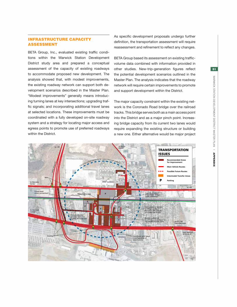
51
Wa
rW
ick
sta
tio
n d
ev
el
oP
Me
nt
dis
tr
ict
Ma
st
er
Pl
an
|
ap
pe
nd
iX
As specific development proposals undergo further
definition, the transportation assessment will require
reassessment and refinement to reflect any changes.
BETA Group based its assessment on existing traffic-
volume data combined with information provided in
other studies. New-trip-generation figures reflect
the potential development scenarios outlined in the
Master Plan. The analysis indicates that the roadway
network will require certain improvements to promote
and support development within the District.
The major capacity constraint within the existing net-
work is the Coronado Road bridge over the railroad
tracks. This bridge serves both as a main access point
into the District and as a major pinch point. Increas-
ing bridge capacity from its current two lanes would
require expanding the existing structure or building
a new one. Either alternative would be major project
infraStructure capacity aSSeSSment
BETA Group, Inc., evaluated existing traffic condi-
tions within the Warwick Station Development
District study area and prepared a conceptual
assessment of the capacity of existing roadways
to accommodate proposed new development. The
analysis showed that, with modest improvements,
the existing roadway network can support both de-
velopment scenarios described in the Master Plan.
“Modest improvements” generally means introduc-
ing turning lanes at key intersections; upgrading traf-
fic signals; and incorporating additional travel lanes
at selected locations. These improvements must be
coordinated with a fully developed on-site roadway
system and a strategy for locating major access and
egress points to promote use of preferred roadways
within the District.
TRANSPORTATIONISSUES
Recommended Areasfor Improvement
Main Vehicle Routes
Possible Future Routes
Intermodal Transfer Areas
ParkingP
52
Wa
rW
ick
sta
tio
n d
ev
el
oP
Me
nt
dis
tr
ict
Ma
st
er
Pl
an
|
ap
pe
nd
iX
with significant costs. Therefore, development in
the District should look to design access points that
minimize the use of the bridge. Improvements made
as part of the train station project have added turn
lanes on all approaches to the intersection of Jef-
ferson Boulevard and Kilvert Street, adjacent to the
station. To minimize the impact of limited capacity on
the railroad bridge, Post Road should be promoted
as the primary access for sites east of the tracks
and Jefferson Boulevard promoted for sites west
of the tracks. Both roadways have good access to
Route I-95 via the Airport Connector and Route 37.
Incorporation of the improvements outlined below
will further enhance this access.
With moderate improvements, the roadway network
has the capacity to accommodate anticipated traf-
fic generated by potential development. Long-term
development beyond that outlined in the Master
Plan, however, may require adding capacity within
the network. Expanding the Coronado Road bridge
could provide some of that additional capacity. As
development begins to remake in the District, the
potential of an expanded bridge crossing should be
studied for engineering and financial feasibility.
The Post Road, Coronado Road, and Jefferson
Boulevard corridors will need several improvements
to provide the infrastructure necessary to support
the uses identified in the Master Plan (See location
diagram on page 53). The study area for develop-
ing these improvements extends from the Airport
Connector north to Route 37 and from Jefferson
Boulevard east to Post Road.
Post road1. Add a right turn lane on northbound Post
Road at its approach to the Lincoln Avenue
intersection. The exclusive right-turn lane will
allow two lanes of Post Road traffic to reach
the two-lane ramp onto Route 37 westbound.
Only a single lane now serves this high-volume
movement, causing confusion and congestion
as a result of the disproportionate use of the
northbound travel lanes. Heavier use of the right
lane, necessitated by the predominant movement
to Route 37, yields extensive queuing on the
northbound approach. Some drivers try to avoid
the queue by using the left lane and then cross-
ing over two lanes to get to the Route 37 ramp,
creating a dangerous conflict with vehicles in the
right lane that continue straight on Post Road.
Adding a second right-turn lane would improve
both safety and operational efficiency at both the
intersection and along Post Road. Introducing the
second lane may require acquisition of a small
amount of the parcel in the southeast quadrant of
the intersection, which is currently vacant.
2. Add a right-turn lane southbound on Post
Road at its intersection with Coronado
Road. Heavy right-turn volume results in queu-
ing along southbound Post Road. Drivers trying
to avoid delays at the intersection tend to cut
through the Hillsgrove North before reaching
Coronado. A right-turn lane will provide additional
capacity to accommodate this demand, helping
reduce southbound queuing and discouraging
cut-through traffic. The improvements will also
accommodate future traffic bound for the District.
Property acquisition will likely be required to build
the turn lane, affecting the gas station on the
northwest corner of the intersection.
3. Add an auxiliary lane southbound on Post
Road between the westbound Airport
Connector ramp and the access to the
Redevelopment District. This right-turn-only
lane to the Airport Connector would also improve
access to/egress from businesses and parking on
this section of Post Road. The lane will accom-
modate traffic from the development destined
for points beyond the city limits and would also
promote use of Post Road as a major egress for
the District while limiting operational impacts on
through traffic along the corridor.
Introduction of this lane could have significant
impact on properties on the western side of Post
Road. Some of these properties, particularly north

53
Wa
rW
ick
sta
tio
n d
ev
el
oP
Me
nt
dis
tr
ict
Ma
st
er
Pl
an
|
ap
pe
nd
iX
of Montebello Road,
may be redeveloped
as part of the Master
Plan. However, impacts
on the Radisson Hotel
and 2105 Post Road
will need to be care-
fully coordinated as
the improvement is
implemented. A smaller
build-out scenario of
500,000 square feet
with decentralized
parking might allow
some delay in full
implementation of the
auxiliary lane. However, even that scenario will
require extending a right-turn-only lane from the
Airport Connector Road ramp northward for ap-
proximately 600 feet to improve operation of the
intersection.
coronado road/kilvert street4. Reconstruct Coronado Road between Post
Road and the railroad bridge to improve
operations at signalized intersections and access
to the Redevelopment District. Improvements in
would include widening the roadway to four lanes
east of the bridge to allow for turning lanes at
intersections. Additional widening could accom-
modate a boulevard-type roadway as the main
route through the District. Providing the neces-
sary corridor for these improvements will require
property acquisition.
5. Development of InterLink has already
improved access from the west. The project
included improvements at the intersection of Jef-
ferson Boulevard, Coronado, and Kilvert—an ad-
ditional westbound right-turn lane on Coronado
and additional left-turn lanes on the eastbound
Kilvert Street approach and on both Jefferson
Boulevard approaches. These improvements
will benefit traffic heading for the District from
the west, although the Coronado Road railroad
bridge will remain a restriction. Future develop-
ment along Jefferson Boulevard will also benefit
from these improvements, although additional
improvements may be needed depending on the
size and type of development.
internal improvementsIn addition to the improvements in the roadway net-
work that serve the District, certain improvements in
the District’s internal roadway network merit serious
consideration. A hierarchy of streets would include
major north/south and east/west routes such as
Post Road, Coronado Road, and Jefferson Boule-
vard. Minor roadways would be developed to serve
individual parcels within the district and to provide
for both vehicular and pedestrian movement within
the district. Improvements in the internal roadway
network appear likely to follow existing rights of way.
Insuring successful functioning of the internal net-
work will require careful attention to the management
of access to the development parcels. Consolidation
of driveway openings, proper driveway spacing,
coordination of driveways with pedestrian pathways,
and visibility to pedestrian movements will enhance
the mobility for all users of the network.
As discussed previously, Imera Avenue and Ful-
lerton Road would serve as primary corridors within
the District. Kilvert, Thurber, and Cottage streets
and Imera Avenue north of Coronado Road would
serve as secondary streets. Fresno, Montebello, and
Alhambra roads would function as service streets.
I-95
AIRPoRT CoNNECToR
JE
FFE
RS
oN
BLv
D.
Po
ST
Ro
AD
RA
IL C
oR
RID
oR
KILvERT ST.
KILvERT ST.
FULLERToN RD.MoNTEBELLo RD.
IME
RA
Av
E.
Co
Ro
NAD
o RD.
INTERLINK
RAIL/BUS STATIoN
HILLSGRovENoRTH
INTERMoDALDISTRICT
GATEWAyDISTRICT
NoRTH
GATEWAyDISTRICT
SoUTH
REDEvELoPMENT DISTRICT
T.F. GREENAIRPoRT
N
5
1
Po
ST R
D.
3
#
24
(off map)
Recommended roadway improvements
refers to recommendations listed on pages 52–53.
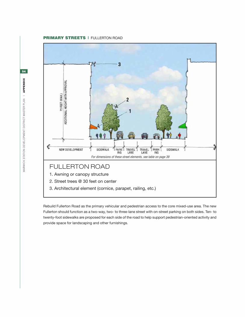
54
Wa
rW
ick
sta
tio
n d
ev
el
oP
Me
nt
dis
tr
ict
Ma
st
er
Pl
an
|
ap
pe
nd
iX
primary StreetS | FULLERTON ROAD
Rebuild Fullerton Road as the primary vehicular and pedestrian access to the core mixed-use area. The new
Fullerton should function as a two-way, two- to three-lane street with on-street parking on both sides. Ten- to
twenty-foot sidewalks are proposed for each side of the road to help support pedestrian-oriented activity and
provide space for landscaping and other furnishings.
FULLERTON ROAD1. Awning or canopy structure
2. Street trees @ 30 feet on center
3. Architectural element (cornice, parapet, railing, etc.)
For dimensions of these street elements, see table on page 39

55
Wa
rW
ick
sta
tio
n d
ev
el
oP
Me
nt
dis
tr
ict
Ma
st
er
Pl
an
|
ap
pe
nd
iX
primary StreetS | IMERA AVENUE
Rebuild Imera Avenue as an internal-movement corridor in the Intermodal Core Area for cars, bikes, and
pedestrians. Development should preserve the option of extending Imera south of Montebello Road as far as
the Airport Connector to accommodate possible future redevelopment in the former Hillsgrove South area.
The new Imera should function as a two-way, two- to three-lane street with on-street parking on each side.
Eight- to twelve-foot sidewalks are suggested on both sides of the road from Montebello Road to Coronado
in order to provide ample room for pedestrians, street trees, and other activities.
ImERA AvENUE1. Awning or canopy structure
2. Street trees @ 30 feet on center
3. Architectural element (cornice, parapet, railing, etc.)
For dimensions of these street elements, see table on page 39

56
Wa
rW
ick
sta
tio
n d
ev
el
oP
Me
nt
dis
tr
ict
Ma
st
er
Pl
an
|
ap
pe
nd
iX
primary StreetS | CORONADO ROAD
Rebuild Coronado Road as a two-way, four-lane street with on-street parking on each side of the road to
the east of Imera Avenue. One or both parking lanes may change to turn lanes at intersections as required.
Eight- to twelve-foot sidewalks are recommended on the north side of the road, and ten- to twenty-foot
sidewalks on the south side to provide ample room for pedestrians, street trees, and other activities.
Add bike lanes between Jefferson Boulevard and Imera Avenue to enhance this important bike connec-
tion across the rail corridor. Consider adding a landscaped median to reduce the expanse of impervious
surface, provide pedestrians with an intermediate stopping point as they cross, and celebrate this block
as a key district gateway.
CORONADO ROAD1. Awning or canopy structure
2. Street trees @ 30 feet on central
3. Architectural element (cornice, parapet, railing, etc.)
For dimensions of these street elements, see table on page 39

57
Wa
rW
ick
sta
tio
n d
ev
el
oP
Me
nt
dis
tr
ict
Ma
st
er
Pl
an
|
ap
pe
nd
iX
Secondary and reSidential StreetS
These include Imera Avenue north of Coronado Road; Kilvert Street; Thurber Street; and Cottage Street.
Secondary and Residential Streets should be two-lane, two-way roads with on-street parking on both sides.
One or two additional lanes may be added and parking removed on Imera south of Alhambra Road and Kilvert
west of Jefferson Boulevard as necessary to accommodate improvements at their respective intersections
with Coronado Road and Jefferson Boulevard. Provide a tree lawn alongside each curb, with the sidewalk
defining its far edge.
SECONDARy AND RESIDENTIAL STREETS1. Awning or canopy structure
2. Street trees @ 30 feet on center
3. Architectural element (cornice, parapet, railing, etc.)
For dimensions of these street elements, see table on page 39