waipa district cycling trails strategic framework · waipa district cycling trails strategic...
TRANSCRIPT

Waipa District Cycling Trails Strategic FrameworkPrepared by Beca Ltd for Waipa District Council20 April 2016

Acknowledgements:
In developing this document we wish to acknowledge the contribution of those people that participated in workshops in late 2015 in both Cambridge and Te Awamutu. The contribution of these parties has been invaluable.

Contents
1 Purpose and Process 1
1.1 Overview and Process 1
1.2 Context 2
2 Vision and Philosophy 32.1 Vision and Branding 3
2.2 Philosophy and Design Standards 3
3 Network Plans 5
4 Implementation 124.1 General Approach 12
4.2 Recreational Riders Network 12
4.3 Road Cycling Network 13
4.4 Urban Network Recreational 13
4.5 Information and Education 13
5 Indicative Cost 14 5.1 Establishment Costs 14
5.2 Operating/ Maintenance Costs 14
5.3 Funding Partners/ Opportunities 14
Page Waipa District Cycling Strategic Framework // Prepared by Beca // April 2016
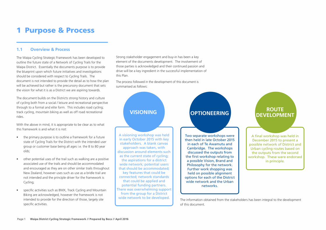
1.1 Overview & Process
The Waipa Cycling Strategic Framework has been developed to outline the future state of a Network of Cycling Trails for the Waipa District. Essentially the documents purpose is to provide the blueprint upon which future initiatives and investigations should be considered with respect to Cycling Trails. The document is not intended to provide the detail as to how the plan will be achieved but rather is the precursory document that sets the vision for what it is as a District we are aspiring towards.
The document builds on the Districts strong history and culture of cycling both from a social / leisure and recreational perspective through to a formal and elite form. This includes road cycling; track cycling, mountain biking as well as off road recreational rides.
With the above in mind, it is appropriate to be clear as to what this framework is and what it is not:
• the primary purpose is to outline a framework for a future state of Cycling Trails for the District with the intended user group or customer base being all ages i.e. the 8 to 80 year olds;
• other potential uses of the trail such as walking are a positive associated use of the trails and should be accommodated and encouraged as they are on other similar trails throughout New Zealand, however uses such as use as a bridle trail are not intended and the principle driver for the framework is Cycling;
• specific activities such as BMX, Track Cycling and Mountain Biking are acknowledged, however the framework is not intended to provide for the direction of those, largely site specific activities.
Strong stakeholder engagement and buy-in has been a key element of the documents development. The involvement of those parties is acknowledged and their continued passion and drive will be a key ingredient in the successful implementation of this Plan.
The process followed in the development of this document is summarised as follows:
1 Purpose & Process
VISIONING OPTIONEERINGROUTE
DEVELOPMENT
A visioning workshop was held in early October 2015 with key stakeholders. A blank canvas
approach was taken, with discussion around elements such
as the current state of cycling; the aspirations for a district
wide network; potential users that should be accommodated;
key features that could be connected; network standards
that could be applied and potential funding partners.
There was overwhelming support from the group for a District
wide network to be developed.
Two separate workshops were then held in late October 2015
in each of Te Awamutu and Cambridge. The workshops discussed the outputs from
the first workshop relating to a possible Vision, Brand and Philosophy for the network. Further work shopping was held on possible alignment
options for each of the District wide network and the Urban
networks.
A final workshop was held in December 2015 to present a
possible network of District and Urban cycling routes based on the outputs from the second
workshop. These were endorsed in principle.
The information obtained from the stakeholders has been integral to the development of this document.
1

Waipa District Cycling Strategic Framework // Prepared by Beca // April 2016 Page
1.2 Context
This cycling strategic framework sits neatly within the key pillars of Waipa’s overall strategic framework:
• Economically progressive
• Environmental and cultural champions
• Connected with our communities
• Socially responsible.
The framework aims to maximise the opportunities to integrate and showcase different parts of the community in a more cohesive and enduring way. It links closely to the work done by the Waikato Regional Council strategic view of the wider region and the opportunities this offers to create a shared vision and a connected net work.
Cycling is business
Waipa recognises the increasing economic value cycling brings to our district and the wider Waikato region. It brings tourism benefits and opportunities for cafes, bike stores, apparel and accommodation providers and other tourism businesses. Cycling events in Waipa attract visitors from around the country and overseas and helps further cement the Home of Champions brand - a key to staking our place in a competitive visitor industry.
Cycling helps tell our story
Ensuring our cycleways connect both people, towns and features means that not only do those using them get some exercise they also learn some of the history and experience some of Waipa’s key environmental features. Our rides will share some of the New Zealand land war history, the pre European stories and showcase some stunning peat lakes and forests.
Cycling connects communities
Cycling is an affordable activity that transcends gender, race, age, and income. It is an accessible pastime that families can do together. It helps people stay healthy and supports commutes and connections between towns and cities (i.e. Hamilton and South Waikato). Cycling provides a common connection for people to spend social and recreational time together (e.g. organised cycling groups, Rider Leader). It also provides a focus for activities like fundraising for future cycleways.
Cycling creates social fabric
We all want healthy communities - families, young people, aging people – and cycling provides just that. It supports those who wish to be more competitive as well as the leisure and recreational riders. It allows all kinds of people to participate, share a journey, some scenery and sites and the camaraderie that
comes with cycling
2

Page Waipa District Cycling Strategic Framework // Prepared by Beca // April 2016
2 Vision and Philosophy
2.1 Vision and Branding
The Vision that is proposed for Cycling within Waipa is:
“For Waipa to be New Zealand’s Home of Cycling, connecting towns, people and significant sites with a safe network of cycling and walking trails around the
district.”
3
A key part of giving effect to this Vision is the development of a District Wide network that will be popular not only to locals but also the tourism market. In order to be successful it will require a point of difference. For Waipa a focus should be on leveraging off the environmental and cultural significance that exists within its District. As such it is recommended that a branding for the District Wide network is considered and adopted, much the same way that other networks leverage off their branding such as the Timberland Trail, Alps to Sea, Otago Rail Trail, Te Awa and the Waikato River Trail.
Options for Waipa could include the Waipa Heritage Trail or the Wonders of Waipa:
2.2 Philosophy and Design Standards
Through the stakeholder engagement and workshop processes it is clear that in order to achieve the vision a multitude of elements relating to cycling need to be undertaken and ultimately then integrated to form a Cycling Network. There are three distinct aspects to the Network Plan and the philosophy and design
approach for each are discussed separately. In all instances the intent is for the Network of trails to provide for cycling and walking. Bridle trails for horses have not been catered for in this framework and within these trails for safety and maintenance reasons, consistent with the New Zealand Cycle Trail Design Guide prepared for the Ministry of Business and Innovation.
It is also important to note that the routes are indicative only at this stage and substantial further work is required to confirm an appropriate alignment, including amongst other items, having landowner and key stakeholder conversations.
2.2.1 Recreational Riders Network
The recreational riders network is essentially the District’s tourist cycling network and will be designed to highlight key locations of heritage, cultural, environmental and recreational value and locations with local amenity services throughout the district. The cycle routes will cater for all ages and cycling ability, and be in the range of 20-30km stretches, which is seen as the ideal range to cater for both locals and tourists. The width of the path will
be as per the recommended NZ cycle trail standards, which is a 2.2m to 2.5m width for off road cycle trails.
These routes will be constructed of all terrain materials, likely of crushed limestone / lime sand and where possible of low gradients. Compacted gravel/limestone is a recommended surface type in the NZ Cycle Trail Design Guide (2011) for Grades of 1, 2, 3 (easiest to intermediate). The NZ Cycle Trail Design Guide Gap also states that “graded aggregates (like railway ballast used on rail trails) form a good structural base with excellent drainage properties and can provide surplus water storage if there is a known flooding problem in the area”.
The intention is for this network to be off-road, utilising wide road berms, paper roads and reserves wherever practicable and private property where achievable and only absolutely necessary. The key sections of the District Wide network are:
• Te Awamutu to Pirongia
• Lake Ngaroto to Mystery Creek
• Cambridge to Te Awamutu
Waipa District Cycling Strategic Framework // Prepared by Beca // April 2016 Page
• Arapuni to Roto-O-Rangi connecting to the Cambridge / Te Awamutu route)
These legs will combine to develop a District wide network. Further detail on these are provided in Section 3. Ultimately it is envisaged that Mystery Creek will connect through to Cambridge as part of the Te Awa rive ride. It should be noted that whilst the network is shown in general terms within Section 3, the actual alignment is likely to change during further investigations of the route. The routes are shown as indicative at this stage and the key elements relate to the places they are seeking to connect rather than the specific alignment shown. Further work will be required to be undertaken, as iterated elsewhere in this framework, before a final route is able to be identified.
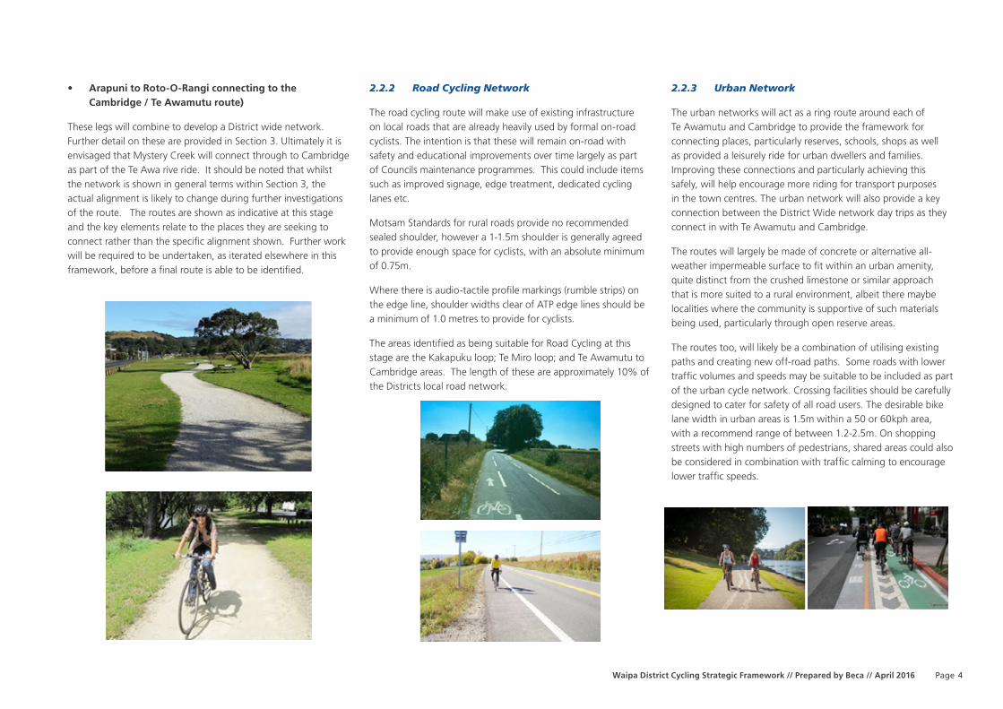
2.2.2 Road Cycling Network
The road cycling route will make use of existing infrastructure on local roads that are already heavily used by formal on-road cyclists. The intention is that these will remain on-road with safety and educational improvements over time largely as part of Councils maintenance programmes. This could include items such as improved signage, edge treatment, dedicated cycling lanes etc.
Motsam Standards for rural roads provide no recommended sealed shoulder, however a 1-1.5m shoulder is generally agreed to provide enough space for cyclists, with an absolute minimum of 0.75m.
Where there is audio-tactile profile markings (rumble strips) on the edge line, shoulder widths clear of ATP edge lines should be a minimum of 1.0 metres to provide for cyclists.
The areas identified as being suitable for Road Cycling at this stage are the Kakapuku loop; Te Miro loop; and Te Awamutu to Cambridge areas. The length of these are approximately 10% of the Districts local road network.
2.2.3 Urban Network
The urban networks will act as a ring route around each of Te Awamutu and Cambridge to provide the framework for connecting places, particularly reserves, schools, shops as well as provided a leisurely ride for urban dwellers and families. Improving these connections and particularly achieving this safely, will help encourage more riding for transport purposes in the town centres. The urban network will also provide a key connection between the District Wide network day trips as they connect in with Te Awamutu and Cambridge.
The routes will largely be made of concrete or alternative all-weather impermeable surface to fit within an urban amenity, quite distinct from the crushed limestone or similar approach that is more suited to a rural environment, albeit there maybe localities where the community is supportive of such materials being used, particularly through open reserve areas.
The routes too, will likely be a combination of utilising existing paths and creating new off-road paths. Some roads with lower traffic volumes and speeds may be suitable to be included as part of the urban cycle network. Crossing facilities should be carefully designed to cater for safety of all road users. The desirable bike lane width in urban areas is 1.5m within a 50 or 60kph area, with a recommend range of between 1.2-2.5m. On shopping streets with high numbers of pedestrians, shared areas could also be considered in combination with traffic calming to encourage lower traffic speeds.
4

Page Waipa District Cycling Strategic Framework // Prepared by Beca // April 2016
3 Network Plans - Waipa District Cycling Network
5

Waipa District Cycling Strategic Framework // Prepared by Beca // April 2016 Page 6
Te Awamutu to Pirongia

Page Waipa District Cycling Strategic Framework // Prepared by Beca // April 20167
Ngaroto to Mystery Creek

Waipa District Cycling Strategic Framework // Prepared by Beca // April 2016 Page 8
Te Awamutu to Cambridge

Page Waipa District Cycling Strategic Framework // Prepared by Beca // April 20169
Arapuni to Rootoorangi

Waipa District Cycling Strategic Framework // Prepared by Beca // April 2016 Page 10
Cambridge Urban Network

Page Waipa District Cycling Strategic Framework // Prepared by Beca // April 2016
Te Awamutu/ Kihikihi Urban Network
11

Page Waipa District Cycling Strategic Framework // Prepared by Beca // April 2016
4 Implementation
4.1 General Approach
The implementation of this Network Plan will be over a number of years, possibly decades and will be undertaken by a number of parties not just by Council. For these very reasons, the importance of the document lies in it setting the vision or strategic direction for the future cycling network so as to avoid projects that don’t fit within the bigger picture concept.
The general approach to implementing this strategy is depicted in the diagram below and follows the typical process of visioning (where we are now) - investigation and reporting - detailed design - construction. Key elements around each of the three key component of the network plan are discussed separately in the following paragraphs.
lso be considered in combination with traffic calming to encourage lower traffic speeds.
4.2 Recreational Riders Network
This network will be implemented over a period of time on a section by section basis. The following process is recommended.
• Section Identified for consideration. This Network Plan provides the framework for the cycling network but specifically doesn’t outline the staging and timelines for delivery of it. Priority should be given to those sections where there is a drive, support and funding partners available within that local community to assist. Priority should also be given to progressing in logical stages to enable connections to be made with already completed stages.
• Investigation & Reporting. This will consider the route in more detail and identify opportunities and constraints through ground investigations and property discussions to enable a defined route to be identified, noting that the routes identified at this stage are conceptual only and are shown to identify a possible means of connecting places and points of interest. This phase will also enable an indicative budget to be developed to determine the viability of the route or whether refinements or value engineering is required to make it more palatable. This phase will also deliver a land requirement plan for any land negotiations / leases that need to be put in place.
• Property Negotiations. Councils Property specialists should lead the discussions and negotiations with landowners where non-council land (i.e. private land, crown land) is required to ensure that there is support in place and the relevant legal instruments such as easements.
• Detailed Design. Following budget approval the route will head into a detailed design phase to enable accurate pricing by contractors in the construction phase. The detailed design phase will be able to focus on any specific structures; earthworks volumes (cut and fill) and volume of materials. An engineer’s estimate will then be provided based on the detailed design
• Construction. Following budget approval of the engineers estimate a tender process should follow to select a preferred contractor to deliver the route.
Key actions in achieving the recreational riders network include:
Key Actions
1. Council identifying an initial route where there is known community engagement to progress through to an investigation and reporting phase. Future steps in the process to follow provided there is continued support and alignment of the project with the strategic framework and budgets
2. Council to identify funding for investigation and reporting phases for the remaining routes to enable understanding of alignment and construction costs to feed into future LTP’s.
Visioning
Investigation and Reporting
Design
Construction
12

Waipa District Cycling Strategic Framework // Prepared by Beca // April 2016 Page
4.3 Road Cycling Network
Implementation of the Road Cycling elements will largely fall to Council to deliver as part of its on-going maintenance and renewals programme of the road asset. Key to the implementation of the Road Cycling network will be the development of route specific plans providing a level of detail that can inform the next LTP round to enable an understanding of costs to feed into budgets over the next 10 year period. In addition to the plan for each route, these areas would benefit from additional education and communication around their use for Road Cycling purposes:
4.4 Urban Network Recreational
Elements of both the Te Awamutu/ Kihikihi and Cambridge urban networks are already in place either as part of the Heritage Trail in Te Awamutu or the Town Belt cycleway in Cambridge. Elements of both of these have been constructed to varying standards. In order to implement completion of both networks over a period of time it is recommended that the following actions are undertaken:
It is recommended that this stocktake and budgeting exercise is completed prior to the next LTP round to enable an understanding of costs to feed into budgets over the next 10 year period.
4.5 Information and Education
In addition to the development of the routes as identified in the sections above, it is appropriate to have more detailed information and support available for Cyclists in the District. Initiatives and key actions could include:
Key Actions
1. In consultation with local cyclist groups who train on these roads, a specific plan should be prepared for each of the 3 Road Cycling study areas (Kakapuku loop; Te Miro loop; and Te Awamutu to Cambridge) to consider opportunities for:
• Signage (and line marking) to improve awareness
• Improved edge protection and consideration of alternative treatment – i.e. a smooth surface, within the cycling lane
• Wider bays / pull off areas in higher risk areas such as bends and the crest of hills.
2. Notification to residents along the route that they live on an identified Road Cycling route;
3. Coordination and Communication of any road cycling events to residents with priority use of these localities for events.
Key Actions
1. A detailed plan or stocktake of each areas is prepared that clearly identifies what is existing, what requires upgrading and what requires new construction
2. Review of Cycling facilities and opportunities within each of the CBD’s
3. Logical stages of works and indicative costs prepared for each stage, essentially a work programme for the next 10 year period.
4. Identification of other sources of funding and possible land use developments that could contribute / construct as part of their development programme.
Key Actions
1. Having an interactive web based tool that identifies networks for cycling within the District and other cycling related information;
2. Working with Schools to identify safe routes and the appropriate treatment of these for getting kids to and from school by bike;
3. Development of school travel plans
13

Page Waipa District Cycling Strategic Framework // Prepared by Beca // April 2016
5 Indicative Costs
Indicative costs for the Road Cycling and Urban Networks will be considered through a more robust process for developing specific plans around those areas.
For the District Wide Recreational Riders network, a very high level indicative cost is provided below to assist in understanding the ballpark setup and operational costs. As identified in the implementation section, the network plan is a visioning exercise to develop the framework, with future phases such as investigation and reporting, detailed design and then contractor procurement able to further refine with more accuracy at each stage, the cost of implementing a section.
5.1 Establishment Costs
The level of information available at this stage is not to the level of understanding what structures etc. may be required, and ultimately it is the structures that will drive up the cost of implementing each section. As an example the cost of constructing the cantilevered bridge structure at Crowsnest hill as part of the Cambridge to Karapiro section of Te Awa was almost equivalent of the cost of constructing the 4km section of cycleway path itself.
As such the cost range is provided as a range only and has been based on the actual cost of delivering cycle ways elsewhere within New Zealand, with the following routes used as examples:
• Clive to Flowerlands (Hawkes Bay) $33,000
• Whitianga Foreshore (Whitianga) $60,000
• Tutaekuri River / Taradale (Hawke Bay) $95,000
• Matua to Wairoa (Tauranga) $150,000 (estimate)
A true cost estimating approach looking at the route and building up the cost has not been undertaken as the level of information as mentioned is not available at such an early stage.
• Indicative Cost Range per Kilometre of Cycleway = $33,000 - $150,000
5.2 Operating / Maintenance Costs
The ongoing operating and maintenance costs could form part of Councils core business and there is the opportunity for efficiencies to be gained through doing this either as a standalone or in combination with adjoining Councils. There will also be efficiencies through economies of scale as the routes increase in length. The additional costs are likely to be in the Recreational Riders network, with the on road and urban networks essentially falling within the day to day business of Council.
A nominal estimated cost of $200,000 per annum for the recreational rider’s network could be expected for the route once fully developed. This would enable a full time contractor, with associated equipment (i.e. a quad bike) and a budget for materials such as weed spray and the replacement of limestone on an as and when required basis.
5.3 Funding Partners / Opportunities
Development of the trails and implementation of the many ideas and actions as outlined in this framework will require a commitment from a number of fronts and contribution from a range of sources. Key to the success will be where there is a strong desire and drive at the local community level to see the individual aspects of the trail to be established.
Key funding contributors and supporters are anticipated to include:
• Local residents and landowners who will derive benefit from the trails
• NZ Transport Agency
• Central Government
• Corporate Sponsors
• Council.
14