w t p s t u a r t - townsville city council · saunders beach alligator creek horseshoe bay town /...
TRANSCRIPT
145 Ann Street Brisbane QLD 4000 Australia T 61 7 3316 3000 F 61 7 3316 3333 E [email protected] W www.ghd.com
O o n o o n b aO o n o o n b a
Z i n c Z i n c P l a n tP l a n t
P O T LP O T L
C l e v e l a n d C l e v e l a n d P a l m sP a l m s
W T P W T P S t u a r tS t u a r t
STUART DRIVE
ABBOTT STREET
BRUCE HIGHWAY
KINGS
ROA
D
BOUNDARY STREETSTURT STREE
T
UNIVERSITY ROAD
INGHAM ROAD
WILLINGDRIVE
QUEENS ROAD
BOWEN ROAD
LOVE LANE
CHAR
TERS
TOWE
RSRO
ADWOOLCOCK STREET RAILW AY AVE NUE
OONOONBA ROAD
BAYSWATER ROAD
ARCHER STREET
STAGPOLE STREET
RACECOURSE ROAD
ACKERS STREET
BRUCE HIGHWAY
T o w n s v i l l e I n n e r S u b u r b sT o w n s v i l l e I n n e r S u b u r b s
M a r i n a M a r i n a C a s i n oC a s i n o
G:\41\24609\GIS\Maps\Working\4124609_PermanentHazard_Current2012_InfraRisk_RevA_20121009.mxd© 2012. Whilst every care has been taken to prepare this map, GHD, TCC, DERM make no representations or warranties about its accuracy, reliability, completeness or suitability for any particular purpose and cannot accept liability and responsibility of any kind (whether in contract, tort or otherwise) for any expenses, losses, damages and/or costs (including indirect or consequential damage) which are or may be incurred by any party as a result of the map being inaccurate, incomplete or unsuitable in any way and for any reason.
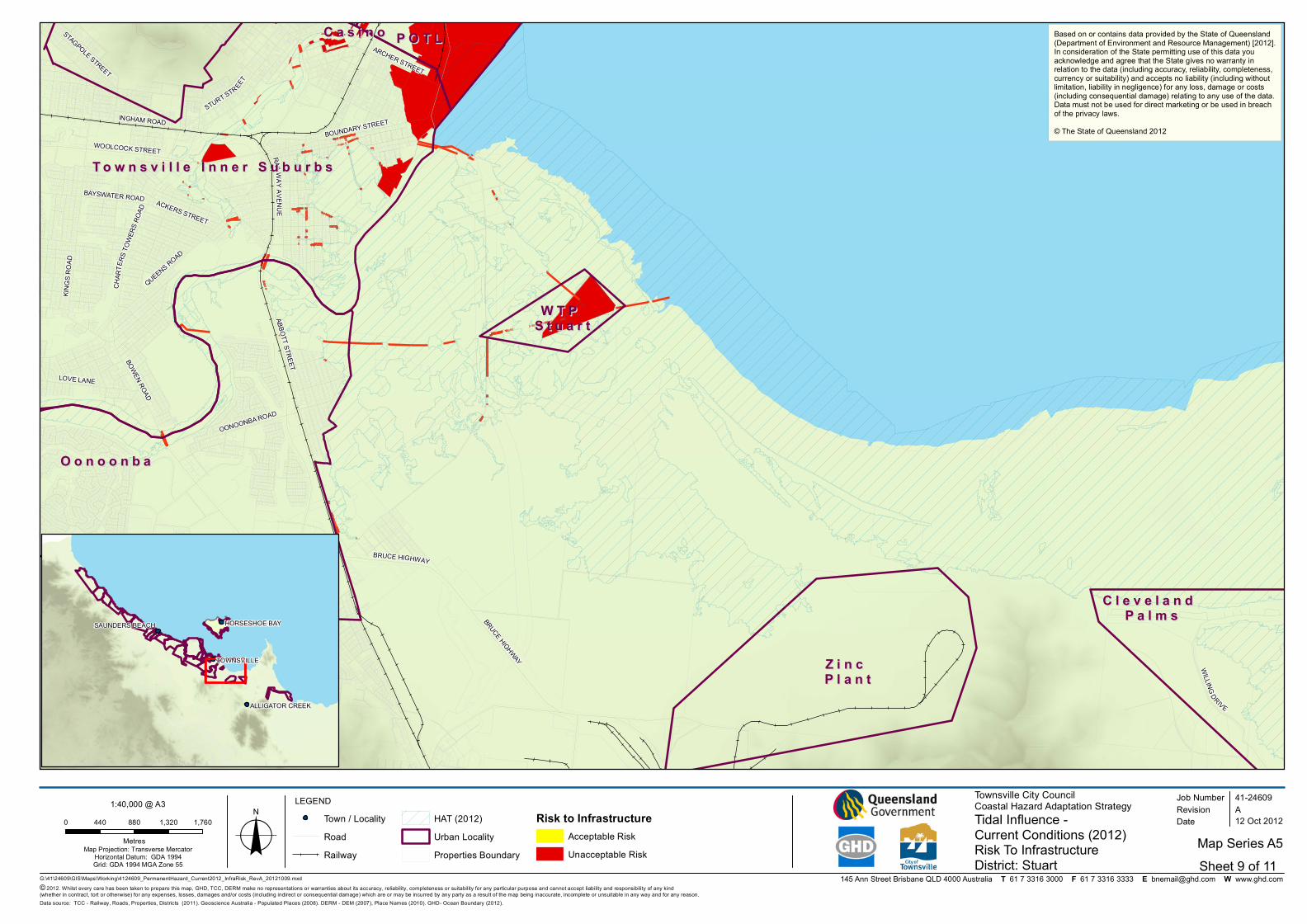
LEGEND Townsville City CouncilCoastal Hazard Adaptation StrategyTidal Influence - Current Conditions (2012)Risk To Infrastructure
Job NumberRevision A
41-24609
12 Oct 2012
District: Stuarto Date
Data source: TCC - Railway, Roads, Properties, Districts (2011). Geoscience Australia - Populated Places (2008). DERM - DEM (2007), Place Names (2010). GHD- Ocean Boundary (2012).
TOWNSVILLE
SAUNDERS BEACH
ALLIGATOR CREEK
HORSESHOE BAY
Town / LocalityRoadRailway
HAT (2012)Urban LocalityProperties Boundary
Risk to InfrastructureAcceptable RiskUnacceptable Risk
Based on or contains data provided by the State of Queensland(Department of Environment and Resource Management) [2012].In consideration of the State permitting use of this data youacknowledge and agree that the State gives no warranty inrelation to the data (including accuracy, reliability, completeness,currency or suitability) and accepts no liability (including withoutlimitation, liability in negligence) for any loss, damage or costs(including consequential damage) relating to any use of the data.Data must not be used for direct marketing or be used in breachof the privacy laws.© The State of Queensland 2012
0 440 880 1,320 1,760
MetresMap Projection: Transverse Mercator
Horizontal Datum: GDA 1994Grid: GDA 1994 MGA Zone 55
1:40,000 @ A3
Map Series A5Sheet 9 of 11

145 Ann Street Brisbane QLD 4000 Australia T 61 7 3316 3000 F 61 7 3316 3333 E [email protected] W www.ghd.com
O o n o o n b aO o n o o n b a
Z i n c Z i n c P l a n tP l a n t
P O T LP O T L
C l e v e l a n d C l e v e l a n d P a l m sP a l m s
W T P W T P S t u a r tS t u a r t
STUART DRIVE
ABBOTT STREET
BRUCE HIGHWAY
KINGS
ROA
D
BOUNDARY STREETSTURT STREE
T
UNIVERSITY ROAD
INGHAM ROAD
WILLINGDRIVE
QUEENS ROAD
BOWEN ROAD
LOVE LANE
CHAR
TERS
TOWE
RSRO
ADWOOLCOCK STREET RAILW AY AVE NUE
OONOONBA ROAD
BAYSWATER ROAD
ARCHER STREET
STAGPOLE STREET
RACECOURSE ROAD
ACKERS STREET
BRUCE HIGHWAY
T o w n s v i l l e I n n e r S u b u r b sT o w n s v i l l e I n n e r S u b u r b s
M a r i n a M a r i n a C a s i n oC a s i n o
G:\41\24609\GIS\Maps\Working\4124609_PermanentHazard_2100Conditions_InfraRisk_RevA_20121009.mxd© 2012. Whilst every care has been taken to prepare this map, GHD, TCC, DERM make no representations or warranties about its accuracy, reliability, completeness or suitability for any particular purpose and cannot accept liability and responsibility of any kind (whether in contract, tort or otherwise) for any expenses, losses, damages and/or costs (including indirect or consequential damage) which are or may be incurred by any party as a result of the map being inaccurate, incomplete or unsuitable in any way and for any reason.
LEGEND Townsville City CouncilCoastal Hazard Adaptation StrategyTidal Influence - 2100 Conditions (0.8m SLR)Risk To Infrastructure Sheet 9 of 11
Job NumberRevision A
41-24609
12 Oct 2012
District: Stuarto Date
Data source: TCC - Railway, Roads, Properties, Districts (2011). Geoscience Australia - Populated Places (2008). DERM - DEM (2007), Place Names (2010). GHD- Ocean Boundary (2012).
TOWNSVILLE
SAUNDERS BEACH
ALLIGATOR CREEK
HORSESHOE BAY
Town / LocalityRoadRailway
Urban LocalityProperties BoundaryHAT2100 Condition (0.8m SLR)
Risk to InfrastructureTolerable RiskUnacceptable Risk
Based on or contains data provided by the State of Queensland(Department of Environment and Resource Management) [2012].In consideration of the State permitting use of this data youacknowledge and agree that the State gives no warranty inrelation to the data (including accuracy, reliability, completeness,currency or suitability) and accepts no liability (including withoutlimitation, liability in negligence) for any loss, damage or costs(including consequential damage) relating to any use of the data.Data must not be used for direct marketing or be used in breachof the privacy laws.© The State of Queensland 2012
0 250 500 750 1,000
MetresMap Projection: Transverse Mercator
Horizontal Datum: GDA 1994Grid: GDA 1994 MGA Zone 55
1:40,000 @ A3
Map Series A6

145 Ann Street Brisbane QLD 4000 Australia T 61 7 3316 3000 F 61 7 3316 3333 E [email protected] W www.ghd.com
O o n o o n b aO o n o o n b a
Z i n c Z i n c P l a n tP l a n t
P O T LP O T L
C l e v e l a n d C l e v e l a n d P a l m sP a l m s
W T P W T P S t u a r tS t u a r t
STUART DRIVE
ABBOTT STREET
BRUCE HIGHWAY
KINGS
ROA
D
BOUNDARY STREETSTURT STREE
T
UNIVERSITY ROAD
INGHAM ROAD
WILLINGDRIVE
QUEENS ROAD
BOWEN ROAD
LOVE LANE
CHAR
TERS
TOWE
RSRO
ADWOOLCOCK STREET RAILW AY AVE NUE
OONOONBA ROAD
BAYSWATER ROAD
ARCHER STREET
STAGPOLE STREET
RACECOURSE ROAD
ACKERS STREET
BRUCE HIGHWAY
T o w n s v i l l e I n n e r S u b u r b sT o w n s v i l l e I n n e r S u b u r b s
M a r i n a M a r i n a C a s i n oC a s i n o
G:\41\24609\GIS\Maps\Working\4124609_Stormtide_Current2012_InfraRisk_RevA_20121009.mxd© 2012. Whilst every care has been taken to prepare this map, GHD, TCC, DERM make no representations or warranties about its accuracy, reliability, completeness or suitability for any particular purpose and cannot accept liability and responsibility of any kind (whether in contract, tort or otherwise) for any expenses, losses, damages and/or costs (including indirect or consequential damage) which are or may be incurred by any party as a result of the map being inaccurate, incomplete or unsuitable in any way and for any reason.
LEGEND Townsville City CouncilCoastal Hazard Adaptation StrategyStorm Tide - Current Conditions (2012)Risk To Infrastructure Sheet 9 of 11
Job NumberRevision A
41-24609
12 Oct 2012
District: Stuarto Date
Data source: TCC - Railway, Roads, Properties, Districts (2011). Geoscience Australia - Populated Places (2008). DERM - DEM (2007), Place Names (2010). GHD- Ocean Boundary (2012).
TOWNSVILLE
SAUNDERS BEACH
ALLIGATOR CREEK
HORSESHOE BAY
Town / LocalityRoadRailway
Urban LocalityProperties BoundaryStorm Tide EventCurrent Conditions (2012)
Risk to InfrastructureAcceptable RiskTolerable RiskUnacceptable Risk
Based on or contains data provided by the State of Queensland(Department of Environment and Resource Management) [2012].In consideration of the State permitting use of this data youacknowledge and agree that the State gives no warranty inrelation to the data (including accuracy, reliability, completeness,currency or suitability) and accepts no liability (including withoutlimitation, liability in negligence) for any loss, damage or costs(including consequential damage) relating to any use of the data.Data must not be used for direct marketing or be used in breachof the privacy laws.© The State of Queensland 2012
0 250 500 750 1,000
MetresMap Projection: Transverse Mercator
Horizontal Datum: GDA 1994Grid: GDA 1994 MGA Zone 55
1:40,000 @ A3
Map Series A7

145 Ann Street Brisbane QLD 4000 Australia T 61 7 3316 3000 F 61 7 3316 3333 E [email protected] W www.ghd.com
O o n o o n b aO o n o o n b a
Z i n c Z i n c P l a n tP l a n t
P O T LP O T L
C l e v e l a n d C l e v e l a n d P a l m sP a l m s
W T P W T P S t u a r tS t u a r t
STUART DRIVE
ABBOTT STREET
BRUCE HIGHWAY
KINGS
ROA
D
BOUNDARY STREETSTURT STREE
T
UNIVERSITY ROAD
INGHAM ROAD
WILLINGDRIVE
QUEENS ROAD
BOWEN ROAD
LOVE LANE
CHAR
TERS
TOWE
RSRO
ADWOOLCOCK STREET RAILW AY AVE NUE
OONOONBA ROAD
BAYSWATER ROAD
ARCHER STREET
STAGPOLE STREET
RACECOURSE ROAD
ACKERS STREET
BRUCE HIGHWAY
T o w n s v i l l e I n n e r S u b u r b sT o w n s v i l l e I n n e r S u b u r b s
M a r i n a M a r i n a C a s i n oC a s i n o
G:\41\24609\GIS\Maps\Working\4124609_Stormtide_2100Condition_InfraRisk_RevA_20121009.mxd© 2012. Whilst every care has been taken to prepare this map, GHD, TCC, DERM make no representations or warranties about its accuracy, reliability, completeness or suitability for any particular purpose and cannot accept liability and responsibility of any kind (whether in contract, tort or otherwise) for any expenses, losses, damages and/or costs (including indirect or consequential damage) which are or may be incurred by any party as a result of the map being inaccurate, incomplete or unsuitable in any way and for any reason.
LEGEND Townsville City CouncilCoastal Hazard Adaptation StrategyStorm Tide - 2100 Conditions (0.8m SLR)Risk To Infrastructure Sheet 9 of 11
Job NumberRevision A
41-24609
12 Oct 2012
District: Stuarto Date
ta source: TCC - Railway, Roads, Properties, Districts (2011). Geoscience Australia - Populated Places (2008). DERM - DEM (2007), Place Names (2010). GHD- Ocean Boundary (2012).
TOWNSVILLE
SAUNDERS BEACH
ALLIGATOR CREEK
HORSESHOE BAY
Town / LocalityRoadRailway
Urban LocalityProperties Boundary100 y Return Period Storm Tide Event2100 Condition (0.8m SLR)
Risk to InfrastructureAcceptable RiskTolerable RiskUnacceptable Risk
Based on or contains data provided by the State of Queensland(Department of Environment and Resource Management) [2012].In consideration of the State permitting use of this data youacknowledge and agree that the State gives no warranty inrelation to the data (including accuracy, reliability, completeness,currency or suitability) and accepts no liability (including withoutlimitation, liability in negligence) for any loss, damage or costs(including consequential damage) relating to any use of the data.Data must not be used for direct marketing or be used in breachof the privacy laws.© The State of Queensland 2012
0 250 500 750 1,000
MetresMap Projection: Transverse Mercator
Horizontal Datum: GDA 1994Grid: GDA 1994 MGA Zone 55
1:40,000 @ A3
Map Series A8

145 Ann Street Brisbane QLD 4000 Australia T 61 7 3316 3000 F 61 7 3316 3333 E [email protected] W www.ghd.com
Z i n c Z i n c P l a n tP l a n t
BRUCE HIGHWAY
STUA
RTDR
IVE
CAPE
CLEVELAND ROAD
FLINDERS HIGHWAY
BENT
LEY D
RIVE
ABBOTT STREET
THE STRAND
WILLING DRIVE
UNIVERSITY ROAD
BOWEN ROAD
C u n g u l l aC u n g u l l a
O o n o o n b aO o n o o n b a
T o w n s v i l l e I n n e r S u b u r b sT o w n s v i l l e I n n e r S u b u r b s
P O T LP O T L
C l e v e l a n d C l e v e l a n d P a l m sP a l m s
S t r a n dS t r a n d
W T P W T P S t u a r tS t u a r t
I n d u s t r i a l I n d u s t r i a l A r e aA r e a M a r i n a M a r i n a
C a s i n oC a s i n o
P a l l a r e n d aP a l l a r e n d a
I n d u s t r i a l I n d u s t r i a l A r e aA r e a
G:\41\24609\GIS\Maps\Working\4124609_PermanentHazard_Current2012_PropRisk_RevA_20121009.mxd© 2012. Whilst every care has been taken to prepare this map, GHD, TCC, DERM make no representations or warranties about its accuracy, reliability, completeness or suitability for any particular purpose and cannot accept liability and responsibility of any kind (whether in contract, tort or otherwise) for any expenses, losses, damages and/or costs (including indirect or consequential damage) which are or may be incurred by any party as a result of the map being inaccurate, incomplete or unsuitable in any way and for any reason.
LEGEND Townsville City CouncilCoastal Hazard Adaptation StrategyTidal Influence - Current Conditions (2012)Risk To Property Sheet 10 of 11
Job NumberRevision A
41-24609
12 Oct 2012
District: South Lando Date
Data source: TCC - Railway, Roads, Properties, Districts (2011). Geoscience Australia - Populated Places (2008). DERM - DEM (2007), Place Names (2010). GHD- Ocean Boundary (2012).
TOWNSVILLE
SAUNDERS BEACH
ALLIGATOR CREEK
HORSESHOE BAY
Town / LocalityRoadRailway
HAT (2012)Urban LocalityProperties Boundary
Risk to PropertyAcceptable RiskTolerable RiskUnacceptable Risk
Based on or contains data provided by the State of Queensland(Department of Environment and Resource Management) [2012].In consideration of the State permitting use of this data youacknowledge and agree that the State gives no warranty inrelation to the data (including accuracy, reliability, completeness,currency or suitability) and accepts no liability (including withoutlimitation, liability in negligence) for any loss, damage or costs(including consequential damage) relating to any use of the data.Data must not be used for direct marketing or be used in breachof the privacy laws.© The State of Queensland 2012
0 1,250 2,500 3,750 5,000
MetresMap Projection: Transverse Mercator
Horizontal Datum: GDA 1994Grid: GDA 1994 MGA Zone 55
1:120,000 @ A3
Map Series A1

145 Ann Street Brisbane QLD 4000 Australia T 61 7 3316 3000 F 61 7 3316 3333 E [email protected] W www.ghd.com
Z i n c Z i n c P l a n tP l a n t
BRUCE HIGHWAY
STUA
RTDR
IVE
CAPE
CLEVELAND ROAD
FLINDERS HIGHWAY
BENT
LEY D
RIVE
ABBOTT STREET
THE STRAND
WILLING DRIVE
UNIVERSITY ROAD
BOWEN ROAD
C u n g u l l aC u n g u l l a
O o n o o n b aO o n o o n b a
T o w n s v i l l e I n n e r S u b u r b sT o w n s v i l l e I n n e r S u b u r b s
P O T LP O T L
C l e v e l a n d C l e v e l a n d P a l m sP a l m s
S t r a n dS t r a n d
W T P W T P S t u a r tS t u a r t
I n d u s t r i a l I n d u s t r i a l A r e aA r e a M a r i n a M a r i n a
C a s i n oC a s i n o
P a l l a r e n d aP a l l a r e n d a
I n d u s t r i a l I n d u s t r i a l A r e aA r e a
G:\41\24609\GIS\Maps\Working\4124609_PermanentHazard_Condition2100_PropRisk_RevA_20121009.mxd© 2012. Whilst every care has been taken to prepare this map, GHD, TCC, DERM make no representations or warranties about its accuracy, reliability, completeness or suitability for any particular purpose and cannot accept liability and responsibility of any kind (whether in contract, tort or otherwise) for any expenses, losses, damages and/or costs (including indirect or consequential damage) which are or may be incurred by any party as a result of the map being inaccurate, incomplete or unsuitable in any way and for any reason.
LEGEND Townsville City CouncilCoastal Hazard Adaptation StrategyTidal Influence - 2100 Conditions (0.8m SLR)Risk To Property Sheet 10 of 11
Job NumberRevision A
41-24609
17 Oct 2012
District: South Lando Date
Data source: TCC - Railway, Roads, Properties, Suburbs, Districts (2011). Geoscience Australia - Populated Places (2008). DERM - DEM (2007), Vulnerbale Lands (2011), Place Names (2010). GHD- Ocean Boundary (2012).
TOWNSVILLE
SAUNDERS BEACH
ALLIGATOR CREEK
HORSESHOE BAY
Town / LocalityRoadRailway
Urban LocalityProperties BoundaryHAT2100 Condition (0.8m SLR)
Risk to PropertyAcceptable RiskTolerable RiskUnacceptable Risk
Based on or contains data provided by the State of Queensland(Department of Environment and Resource Management) [2012].In consideration of the State permitting use of this data youacknowledge and agree that the State gives no warranty inrelation to the data (including accuracy, reliability, completeness,currency or suitability) and accepts no liability (including withoutlimitation, liability in negligence) for any loss, damage or costs(including consequential damage) relating to any use of the data.Data must not be used for direct marketing or be used in breachof the privacy laws.© The State of Queensland 2012
0 1,250 2,500 3,750 5,000
MetresMap Projection: Transverse Mercator
Horizontal Datum: GDA 1994Grid: GDA 1994 MGA Zone 55
1:120,000 @ A3
Map Series A2

145 Ann Street Brisbane QLD 4000 Australia T 61 7 3316 3000 F 61 7 3316 3333 E [email protected] W www.ghd.com
Z i n c Z i n c P l a n tP l a n t
BRUCE HIGHWAY
STUA
RTDR
IVE
CAPE
CLEVELAND ROAD
FLINDERS HIGHWAY
BENT
LEY D
RIVE
ABBOTT STREET
THE STRAND
WILLING DRIVE
UNIVERSITY ROAD
BOWEN ROAD
C u n g u l l aC u n g u l l a
O o n o o n b aO o n o o n b a
T o w n s v i l l e I n n e r S u b u r b sT o w n s v i l l e I n n e r S u b u r b s
P O T LP O T L
C l e v e l a n d C l e v e l a n d P a l m sP a l m s
S t r a n dS t r a n d
W T P W T P S t u a r tS t u a r t
I n d u s t r i a l I n d u s t r i a l A r e aA r e a M a r i n a M a r i n a
C a s i n oC a s i n o
P a l l a r e n d aP a l l a r e n d a
I n d u s t r i a l I n d u s t r i a l A r e aA r e a
G:\41\24609\GIS\Maps\Working\4124609_Stormtide_Current2012_PropRisk_RevA_20121009.mxd© 2012. Whilst every care has been taken to prepare this map, GHD, TCC, DERM make no representations or warranties about its accuracy, reliability, completeness or suitability for any particular purpose and cannot accept liability and responsibility of any kind (whether in contract, tort or otherwise) for any expenses, losses, damages and/or costs (including indirect or consequential damage) which are or may be incurred by any party as a result of the map being inaccurate, incomplete or unsuitable in any way and for any reason.
LEGEND Townsville City CouncilCoastal Hazard Adaptation StrategyStorm Tide - Current Conditions (2012)Risk To Property Sheet 10 of 11
Job NumberRevision A
41-24609
17 Oct 2012
District: South Lando Date
Data source: TCC - Railway, Roads, Properties, Districts (2011). Geoscience Australia - Populated Places (2008). DERM - DEM (2007), Place Names (2010). GHD- Ocean Boundary (2012).
TOWNSVILLE
SAUNDERS BEACH
ALLIGATOR CREEK
HORSESHOE BAY
Town / LocalityRoadRailway
Urban LocalityProperties BoundaryStorm Tide EventCurrent Conditions (2012)
Risk to Property Acceptable RiskUnacceptable Risk
Based on or contains data provided by the State of Queensland(Department of Environment and Resource Management) [2012].In consideration of the State permitting use of this data youacknowledge and agree that the State gives no warranty inrelation to the data (including accuracy, reliability, completeness,currency or suitability) and accepts no liability (including withoutlimitation, liability in negligence) for any loss, damage or costs(including consequential damage) relating to any use of the data.Data must not be used for direct marketing or be used in breachof the privacy laws.© The State of Queensland 2012
0 1,250 2,500 3,750 5,000
MetresMap Projection: Transverse Mercator
Horizontal Datum: GDA 1994Grid: GDA 1994 MGA Zone 55
1:120,000 @ A3
Map Series A3

145 Ann Street Brisbane QLD 4000 Australia T 61 7 3316 3000 F 61 7 3316 3333 E [email protected] W www.ghd.com
Z i n c Z i n c P l a n tP l a n t
BRUCE HIGHWAY
STUA
RTDR
IVE
CAPE
CLEVELAND ROAD
FLINDERS HIGHWAY
BENT
LEY D
RIVE
ABBOTT STREET
THE STRAND
WILLING DRIVE
UNIVERSITY ROAD
BOWEN ROAD
C u n g u l l aC u n g u l l a
O o n o o n b aO o n o o n b a
T o w n s v i l l e I n n e r S u b u r b sT o w n s v i l l e I n n e r S u b u r b s
P O T LP O T L
C l e v e l a n d C l e v e l a n d P a l m sP a l m s
S t r a n dS t r a n d
W T P W T P S t u a r tS t u a r t
I n d u s t r i a l I n d u s t r i a l A r e aA r e a M a r i n a M a r i n a
C a s i n oC a s i n o
P a l l a r e n d aP a l l a r e n d a
I n d u s t r i a l I n d u s t r i a l A r e aA r e a
G:\41\24609\GIS\Maps\Working\4124609_Stormtide_2100Condition_PropRisk_RevA_20121009.mxd© 2012. Whilst every care has been taken to prepare this map, GHD, TCC, DERM make no representations or warranties about its accuracy, reliability, completeness or suitability for any particular purpose and cannot accept liability and responsibility of any kind (whether in contract, tort or otherwise) for any expenses, losses, damages and/or costs (including indirect or consequential damage) which are or may be incurred by any party as a result of the map being inaccurate, incomplete or unsuitable in any way and for any reason.
LEGEND Townsville City CouncilCoastal Hazard Adaptation StrategyStorm Tide - 2100 Conditions (0.8m SLR)Risk To Property Sheet 10 of 11
Job NumberRevision A
41-24609
17 Oct 2012
District: South Lando Date
Data source: TCC - Railway, Roads, Properties, Districts (2011). Geoscience Australia - Populated Places (2008). DERM - DEM (2007), Place Names (2010). GHD- Ocean Boundary (2012).
TOWNSVILLE
SAUNDERS BEACH
ALLIGATOR CREEK
HORSESHOE BAY
Town / LocalityRoadRailway
District BoundaryProperties Boundary100 y Return Period Storm Tide Event2100 Conditions (0.8m SLR)
Risk to PropertyAcceptable RiskUnacceptable Risk
Based on or contains data provided by the State of Queensland(Department of Environment and Resource Management) [2012].In consideration of the State permitting use of this data youacknowledge and agree that the State gives no warranty inrelation to the data (including accuracy, reliability, completeness,currency or suitability) and accepts no liability (including withoutlimitation, liability in negligence) for any loss, damage or costs(including consequential damage) relating to any use of the data.Data must not be used for direct marketing or be used in breachof the privacy laws.© The State of Queensland 2012
0 1,250 2,500 3,750 5,000
MetresMap Projection: Transverse Mercator
Horizontal Datum: GDA 1994Grid: GDA 1994 MGA Zone 55
1:120,000 @ A3
Map Series A4

145 Ann Street Brisbane QLD 4000 Australia T 61 7 3316 3000 F 61 7 3316 3333 E [email protected] W www.ghd.com
Z i n c Z i n c P l a n tP l a n t
BRUCE HIGHWAY
STUA
RTDR
IVE
CAPE
CLEVELAND ROAD
FLINDERS HIGHWAY
BENT
LEY D
RIVE
ABBOTT STREET
THE STRAND
WILLING DRIVE
UNIVERSITY ROAD
BOWEN ROAD
C u n g u l l aC u n g u l l a
O o n o o n b aO o n o o n b a
T o w n s v i l l e I n n e r S u b u r b sT o w n s v i l l e I n n e r S u b u r b s
P O T LP O T L
C l e v e l a n d C l e v e l a n d P a l m sP a l m s
S t r a n dS t r a n d
W T P W T P S t u a r tS t u a r t
I n d u s t r i a l I n d u s t r i a l A r e aA r e a M a r i n a M a r i n a
C a s i n oC a s i n o
P a l l a r e n d aP a l l a r e n d a
I n d u s t r i a l I n d u s t r i a l A r e aA r e a
G:\41\24609\GIS\Maps\Working\4124609_PermanentHazard_Current2012_InfraRisk_RevA_20121009.mxd© 2012. Whilst every care has been taken to prepare this map, GHD, TCC, DERM make no representations or warranties about its accuracy, reliability, completeness or suitability for any particular purpose and cannot accept liability and responsibility of any kind (whether in contract, tort or otherwise) for any expenses, losses, damages and/or costs (including indirect or consequential damage) which are or may be incurred by any party as a result of the map being inaccurate, incomplete or unsuitable in any way and for any reason.
LEGEND Townsville City CouncilCoastal Hazard Adaptation StrategyTidal Influence - Current Conditions (2012)Risk To Infrastructure
Job NumberRevision A
41-24609
12 Oct 2012
District: South Lando Date
Data source: TCC - Railway, Roads, Properties, Districts (2011). Geoscience Australia - Populated Places (2008). DERM - DEM (2007), Place Names (2010). GHD- Ocean Boundary (2012).
TOWNSVILLE
SAUNDERS BEACH
ALLIGATOR CREEK
HORSESHOE BAY
Town / LocalityRoadRailway
HAT (2012)Urban LocalityProperties Boundary
Risk to InfrastructureAcceptable RiskUnacceptable Risk
Based on or contains data provided by the State of Queensland(Department of Environment and Resource Management) [2012].In consideration of the State permitting use of this data youacknowledge and agree that the State gives no warranty inrelation to the data (including accuracy, reliability, completeness,currency or suitability) and accepts no liability (including withoutlimitation, liability in negligence) for any loss, damage or costs(including consequential damage) relating to any use of the data.Data must not be used for direct marketing or be used in breachof the privacy laws.© The State of Queensland 2012
0 1,300 2,600 3,900 5,200
MetresMap Projection: Transverse Mercator
Horizontal Datum: GDA 1994Grid: GDA 1994 MGA Zone 55
1:120,000 @ A3
Map Series A5Sheet 10 of 11
145 Ann Street Brisbane QLD 4000 Australia T 61 7 3316 3000 F 61 7 3316 3333 E [email protected] W www.ghd.com
Z i n c Z i n c P l a n tP l a n t
BRUCE HIGHWAY
STUA
RTDR
IVE
CAPE
CLEVELAND ROAD
FLINDERS HIGHWAY
BENT
LEY D
RIVE
ABBOTT STREET
THE STRAND
WILLING DRIVE
UNIVERSITY ROAD
BOWEN ROAD
C u n g u l l aC u n g u l l a
O o n o o n b aO o n o o n b a
T o w n s v i l l e I n n e r S u b u r b sT o w n s v i l l e I n n e r S u b u r b s
P O T LP O T L
C l e v e l a n d C l e v e l a n d P a l m sP a l m s
S t r a n dS t r a n d
W T P W T P S t u a r tS t u a r t
I n d u s t r i a l I n d u s t r i a l A r e aA r e a M a r i n a M a r i n a
C a s i n oC a s i n o
P a l l a r e n d aP a l l a r e n d a
I n d u s t r i a l I n d u s t r i a l A r e aA r e a
G:\41\24609\GIS\Maps\Working\4124609_PermanentHazard_2100Conditions_InfraRisk_RevA_20121009.mxd© 2012. Whilst every care has been taken to prepare this map, GHD, TCC, DERM make no representations or warranties about its accuracy, reliability, completeness or suitability for any particular purpose and cannot accept liability and responsibility of any kind (whether in contract, tort or otherwise) for any expenses, losses, damages and/or costs (including indirect or consequential damage) which are or may be incurred by any party as a result of the map being inaccurate, incomplete or unsuitable in any way and for any reason.
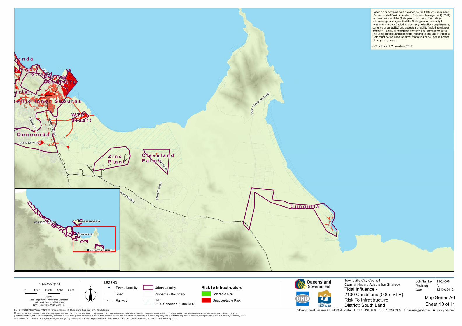
LEGEND Townsville City CouncilCoastal Hazard Adaptation StrategyTidal Influence - 2100 Conditions (0.8m SLR)Risk To Infrastructure Sheet 10 of 11
Job NumberRevision A
41-24609
12 Oct 2012
District: South Lando Date
Data source: TCC - Railway, Roads, Properties, Districts (2011). Geoscience Australia - Populated Places (2008). DERM - DEM (2007), Place Names (2010). GHD- Ocean Boundary (2012).
TOWNSVILLE
SAUNDERS BEACH
ALLIGATOR CREEK
HORSESHOE BAY
Town / LocalityRoadRailway
Urban LocalityProperties BoundaryHAT2100 Condition (0.8m SLR)
Risk to InfrastructureTolerable RiskUnacceptable Risk
Based on or contains data provided by the State of Queensland(Department of Environment and Resource Management) [2012].In consideration of the State permitting use of this data youacknowledge and agree that the State gives no warranty inrelation to the data (including accuracy, reliability, completeness,currency or suitability) and accepts no liability (including withoutlimitation, liability in negligence) for any loss, damage or costs(including consequential damage) relating to any use of the data.Data must not be used for direct marketing or be used in breachof the privacy laws.© The State of Queensland 2012
0 1,250 2,500 3,750 5,000
MetresMap Projection: Transverse Mercator
Horizontal Datum: GDA 1994Grid: GDA 1994 MGA Zone 55
1:120,000 @ A3
Map Series A6