village disaster management plan ambala template budha... · department of revenue & disaster...
TRANSCRIPT
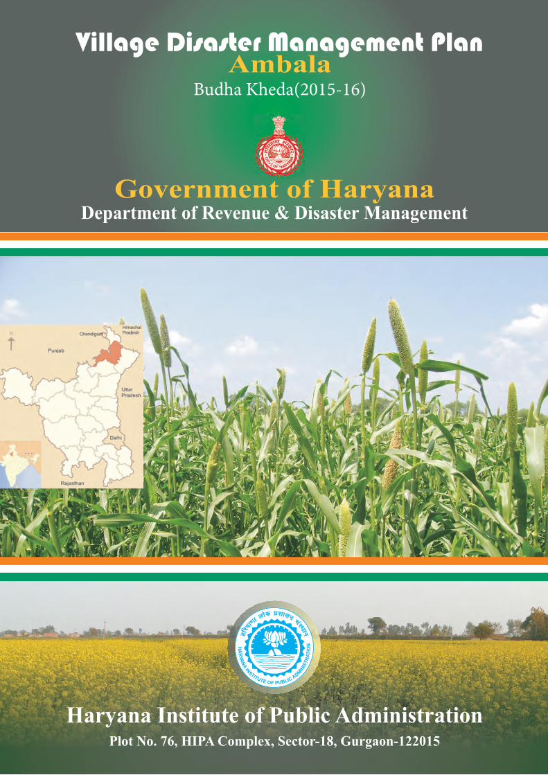
Government of Haryana Department of Revenue & Disaster Management
Haryana Institute of Public AdministrationPlot No. 76, HIPA Complex, Sector-18, Gurgaon-122015
Village Disaster Management Plan Ambala
Budha Kheda(2015-16)
Page No.
1. Introduction 01 1.1 Village profile 01 1.2 Demography 01 1.3 Topography 01 1.4 Social and Economic structure 01 1.5 Climate & rainfall 01 1.6 Land Use pattern 01 1.7 Drinking water & Sanitation facilities 01 1.8 Transport facilities 01
2. Hazard, Vulnerability and Capacity Analysis 03 2.1 Hazards profile of Village 01 2.2 Vulnerability assessment 01 2.3 Capacity Analysis 01
2.3.1 Skilled/Trained Human Resource 01 2.3.2 Resource Inventory 01
2.4 Risk Analysis 01 3. Response plan 06
3.1 Village Disaster Management Committee 01 3.2 Teams under VDMC 01
3.2.1 Early warning, Communication & Awareness Generation Team 01 3.2.2 Evacuation Team 01 3.2.3 Search and Rescue Team 01 3.2.4 First Aid Team 01 3.2.5 Relief management team 01 3.2.6 Shelter Management team 01 3.2.7 Carcass management team 01 3.2.8 Damage & Need assessment team 3.2.9 Rehabilitation & Reconstruction team 01
3.3 Local NGOs & SHGs 01
4. Mitigation and Preparedness Plan 09 4.1 Standard operating Procedure of teams 01 4.2 Identification of open spaces 01 4.3 Community level Mitigation programme 4.4 Rural Development Schemes and Disaster Management 01
5. Contact Detail & updating of plan 10
Chapter -01
Introduction
Village Profile:- The India Village Budha Khera, is located in the taluk of Naraingarh, district of Ambala, in the State of Haryana.
About Budha Khera at glance :-
• Budha Khera Budha Khera is a Village in Naraingarh Tehsil in Ambala District of Haryana State, India
• It belongs to Ambala Division • It is located 41 KM towards East from District head quarters Ambala • 51 KM from State capital Chandigarh Budha Khera is surrounded by Shahzadpur
Tehsil towards west , Sadaura (Part) Tehsil towards South , Raipur Rani Tehsil towards North , Nahan Tehsil towards East
• Nahan , Babiyal , Ambala , Ambala are the nearby Cities to Budha Khera • This Place is in the border of the Ambala District and Yamunanagar District • Yamunanagar District Sadaura (part) is South towards this place • Also it is in the Border of other district Sirmaur • It is near to the Himachal Pradesh State Border • Demographics of Budha Khera Hindi is the Local Language here.
Location Details Tehsil Name : Naraingarh District : Ambala State : Haryana Division : Ambala Language : Hindi and Punjabi Time zone: IST (UTC+5:30) Elevation / Altitude: 275 meters. Above Seal level Telephone Code / Std Code: 0184 Train connectivity There is no railway station near to Budha Khera in less than 10 km. How ever Ambala Cant Jn Rail Way Station is major railway station 36 KM near to Budha Khera Pincodes near Budha Khera 134203 ( Naraingarh ) , 133204 ( Sadhaura ) , 134202 ( Shahzadpur ) Nearby Railway Stations Kesri- 32 KM Tandwal- 33 KM Barara- 33 KM Dukheri- 34 KM Village at-a-glance as under:-

Particulars Detail
Village hadbast Number 112
Area (Hectares) 549(ACRA)
Gram Panchayat Budha Kheda
Patwar halka Jyoly
No. of House Holds 122
CD Block Naraingarh
Tehsil Naraingarh
Police Station Naraingarh
Education Institutes Govt.School
Health Institutions NA
Religious Institutions NA
Primary Source of Livelihood Agriculture
Natural resources Pond
No. of factories/Industries NA
1.1 Demography :-
Budha Khera is a medium size village located in Naraingarh of Ambala district, Haryana with total 133 families residing. The Budha Khera village has population of 663 of which 368 are males while 295 are females as per Population Census 2011. In Budha Khera village population of children with age 0-6 is 61 which makes up 9.20 % of total population of village. Average Sex Ratio of Budha Khera village is 802 which is lower than Haryana state average of 879. Child Sex Ratio for the Budha Khera as per census is 968, higher than Haryana average of 834.
1.2 the total population of village is 663 with Male Population of 368 and female of 295 . Its other statics are as below:-
Description Persons Males Females
Total Population 663 368 295

Population in the age-group 0-6
61 31 30
SC population 195 110 85
Literacy rate 78.57% 85.76% 69.43%
Total workers 184 168 16
Total Non-workers
463 - -
People with disability
6 4 2
Senior citizens 52 31 21
1.3 Topography:- elevation Plane area, Sand dunes, hill locked.
1.4 literacy rate :- Budha Khera village has higher literacy rate compared to Haryana. In 2011, literacy rate of Budha Khera village was 78.57 % compared to 75.55 % of Haryana. In Budha Khera Male literacy stands at 85.76 % while female literacy rate was 69.43 %.
1.5 Caste Factor:- Budha Khera village of Ambala has substantial population of Schedule Caste. Schedule Caste (SC) constitutes 29.41 % of total population in Budha Khera village. The village Budha Khera currently doesn’t have any Schedule Tribe (ST) population.
1.6 Temperature and rainfall:- The climate is Semiarid and hot which is mainly dry with very hot summer and cold winter except during monsoon. Here experience extreme temperature ranges 2-47 degree centigrade with severe cold in month of December & January and the month of May & June are of bitter summer. The annual average rainfall in the district is 569.6 mm. About 70 per cent of the annual rainfall is received during period from July to September.
1.7 Work Profile:- In Budha Khera village out of total population, 184 were engaged in work activities. 83.15 % of workers describe their work as Main Work (Employment or Earning more than 6 Months) while 16.85 % were involved in Marginal activity providing livelihood for less than 6 months. Of 184 workers engaged in Main Work, 92 were cultivators (owner or co-owner) while 18 were Agricultural labourer.
1.8 Land use pattern:-
Sr.No Land use Area in hectrs
1. Agriculture 3860K 7M
2. Forest -
3. Wasteland 508K 8M
1.9 Drinking Water & Sanitation facilities:- the main source of drinking water located within premises of Village and supply of drinking water in village as per below:-
Tap water from treated sources
Tap water from untreated sources
Covered wells
Uncovered wells
Hand pumps
Tube wells/ boreholes
Other sources
Public health Supply
nil 3 1 21 25 nil
Sanitation Facilities:- the total Households are 100 in the village. Out of which only 100 households having latrine facility at their own house premises and rest 20 of households have not latrine facility. These households use alternative sources i.e public toilets and open spaces.
Total House holds Latrine Facility at house Latrine facility not at house
120 100 20
1.10 Transportation Facilities:- The village is well connected with surrounding village with local roads and SH/NH/ District road/other roads connected village to other important places such as Block, Tehsil, District headquarter.
Chapter 2: Hazard, Risk, Vulnerability, Capacity Assessment
2.1 Hazard: The Hazard Profile of the Village
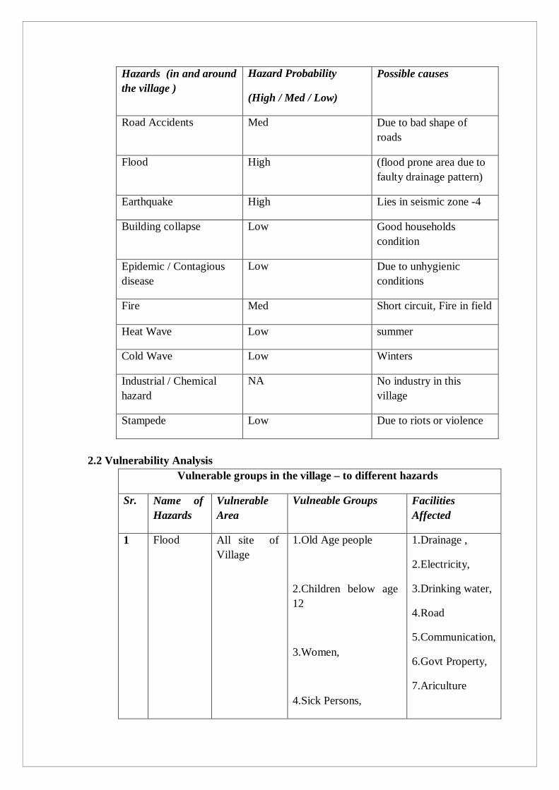
Hazards (in and around the village )
Hazard Probability
(High / Med / Low)
Possible causes
Road Accidents Med Due to bad shape of roads
Flood High (flood prone area due to faulty drainage pattern)
Earthquake High Lies in seismic zone -4
Building collapse Low Good households condition
Epidemic / Contagious disease
Low Due to unhygienic conditions
Fire Med Short circuit, Fire in field
Heat Wave Low summer
Cold Wave Low Winters
Industrial / Chemical hazard
NA No industry in this village
Stampede Low Due to riots or violence
2.2 Vulnerability Analysis
Vulnerable groups in the village – to different hazards
Sr. Name of Hazards
Vulnerable Area
Vulneable Groups Facilities Affected
1 Flood All site of Village
1.Old Age people
2.Children below age 12
3.Women,
4.Sick Persons,
1.Drainage ,
2.Electricity,
3.Drinking water,
4.Road
5.Communication,
6.Govt Property,
7.Ariculture
5.Below Poverty Line
8.Animal Losses
2 Fire Filed Area Farmers and their dependents
1.Electricity,
2. LPG gas cyclinder usage in households
2.Crop Damage
3 Epidemics Flood affected area and nearby
All community of village
Medical facilities,
transport
4 Snake bite Flood affected area and nearby
All community of village
Medical Facilities,
transport
5 Hailstorm Low possibility
6 Pest Attack
Agriculture area
Can be in crops. Crop Failure
7 Heat Wave
Village population Medical Facilities
8 Cold Wave
Village population Medical Facilities
9 Road Accidents
Houses Nearby Road
Road locations houses
Other Vulnerabilities ( Impacts)

1 Social Vulnerabilities
Culture of Village can be affected
Living Pattern, Dress, Food Habits and the employment kind of village will be changed if hazard occurs
2 Political Vulnerabilities
Political System also affect
Group Clashes, Clashes on Compensation,other interference of local group or parties.
2.3 Risk Analysis Severity Hazard Elements at Risk Vulnerable Areas
High Risk Hazards
Earthquake Human life, cattle life, public infrastructure, environment, etc.
Entire village falls in EQ Zone- IV i.e. high damage risk zone.
Floods Human Life, cattle life, Environment, etc.
High risk due to breaches in markanda river
Fires Human Loss, cattle life, agricultural produce, kutcha houses, industries, etc.
Agricultural Land/ villagers and their households
Road Accidents
People travelling on roof/ inside buses. on national Highways, state Highways and other district. Cattle and other animals.
Villagers
Medium Risk Hazards
Extreme Temperature
Human life, Cattle population, Crops, transportation activities.
Floods Human life, cattle life, crop life, property and public infrastructure.
Block naraingarh ambala is flood prone area
Epidemic Human Life, animal life
Low risk Hazards
Drought Human Life, crop life, Cattle life,
Entire village is prone to drought like condition. Ground water depletion is maximum as tube wells

remain the alternate source of water.
Frost Thunder storm Hailstorm
Crop, cattle life Human life, crop , Cattle life, Public infrastructure
People with poor housing conditions in the village.
Terrorist Attack
Crowded places Bus stops, Malls, Hospitals, Places of Worship, Melas etc in the village.
2.2 Vulnerability assessment:-
Details No. of HH
HH in low lying areas No
HH with poorly constructed houses 10
Old aged population (above 65 age) 51
Children below (0-6 age) 61
Women headed households 20
BPL population 66
Landless HH 20
HH (Low income group) 100
2.3 Capacity assessment:-
ANM Sunita
Education
Infrastructure Nos. No. of Rooms
No. of Teachers
No. of Students
Safe Shelters
(Yes / No)
Anganwadi centre 01 01 01 Yes
Primary school 01 01 01 26

Medium school 08 3 36
High school
Secondary school
District Level Emergency Response Teams
a) District Red- Cross Society: 0171, 2530556 Sr. No.
Name Designation Contact No.
1. Sh.Anil Joshi Secy, Red Cross 2530556
2. Sh.hamesh Chand Trainer 9416494782
3. Sh. Rohit Assistant 9815479631
4. Sh.Ram Murti Sharma
Trainer 09315862004
5. Sh.Manoj Assistant 08199830114
b) Fire Brigade: 101
Sr. No.
Name LOCATION Contact No.
1. Sh.A K Sharma (Fire BRIGADE A/cantt 101,9416833887
2. Sh.Pankaj Fire brigade city 9416192080
c) Municipal Committee Ambala Sr. No.
Name Designation Contact No.
1. Sh ramesh mal Mayor 2441077
2. Sh. Ajay Singh tomar Commissioner municipal corporation
2444541
3. Dr Pradeep Kumar E.O ,M.C Ambala 8199830029
4. Sh. Mangla XEN-HQ,M.C ;Ambala city 9466665959
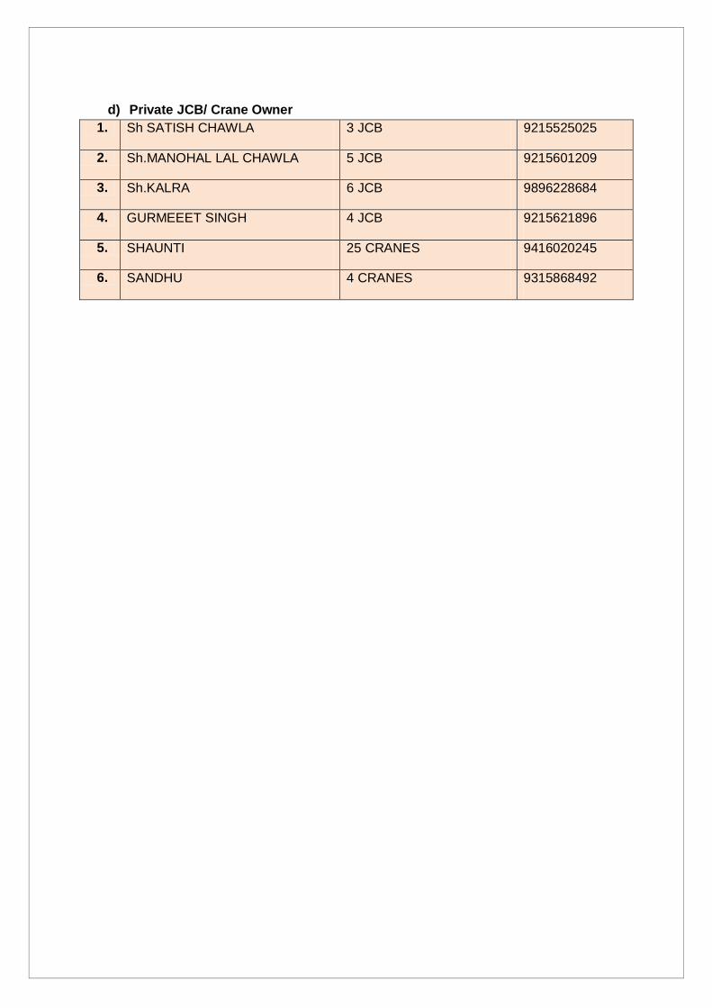
d) Private JCB/ Crane Owner
1. Sh SATISH CHAWLA 3 JCB 9215525025
2. Sh.MANOHAL LAL CHAWLA 5 JCB 9215601209
3. Sh.KALRA 6 JCB 9896228684
4. GURMEEET SINGH 4 JCB 9215621896
5. SHAUNTI 25 CRANES 9416020245
6. SANDHU 4 CRANES 9315868492

Chapter-03
Response Plan
3.1 Village Disaster Management Committee :- to carry out disaster management activities
i.e. village disaster management plan, training and awareness activities, identification of
resources and search & rescue activity at village level conducted by Village Disaster
Management Committee. The following is the suggestive list of committee members:-
Sr.No. Name Designation Contact number
1. Sarpanch – Rajni Devi Chairman 9896178870
2. Panchayat secy – Ranjit Singh Nodal Officer 9812168938
3. Patwari – pushpender Member 9812168938
4. Numbardar -Gurmail Member -
5. SC panch –Rajbir Member -
6. BC panch –Sher Singh Member -
7. Anganwari worker – Usha Devi Member -
8. Woman Panch – Usha Devi Member -
9. Ex-servicemen – Ram Lal Member 9896178870
3.2 Village Disaster Management teams :-
S. No. Name Designation Contact Number Contact Address
Early Warning and Information Dissemination Team
1 Ram Lal Village resident 9896178870 Village resident
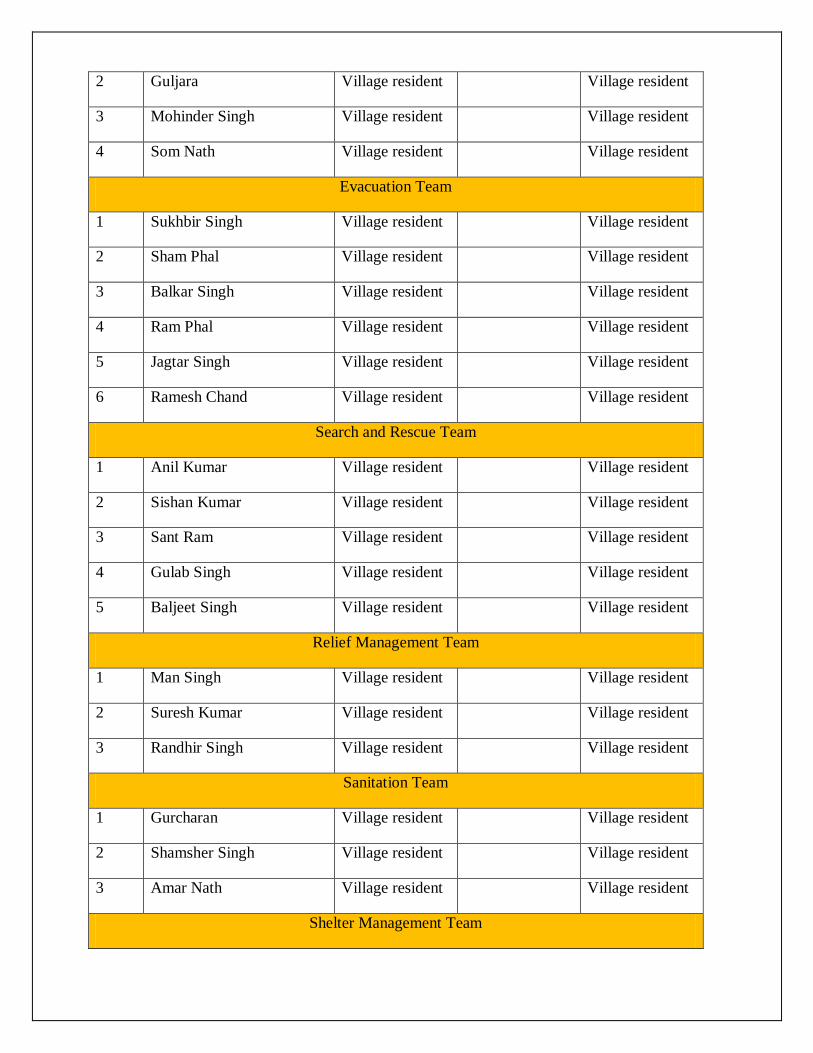
2 Guljara Village resident Village resident
3 Mohinder Singh Village resident Village resident
4 Som Nath Village resident Village resident
Evacuation Team
1 Sukhbir Singh Village resident Village resident
2 Sham Phal Village resident Village resident
3 Balkar Singh Village resident Village resident
4 Ram Phal Village resident Village resident
5 Jagtar Singh Village resident Village resident
6 Ramesh Chand Village resident Village resident
Search and Rescue Team
1 Anil Kumar Village resident Village resident
2 Sishan Kumar Village resident Village resident
3 Sant Ram Village resident Village resident
4 Gulab Singh Village resident Village resident
5 Baljeet Singh Village resident Village resident
Relief Management Team
1 Man Singh Village resident Village resident
2 Suresh Kumar Village resident Village resident
3 Randhir Singh Village resident Village resident
Sanitation Team
1 Gurcharan Village resident Village resident
2 Shamsher Singh Village resident Village resident
3 Amar Nath Village resident Village resident
Shelter Management Team
1 Mahabir Singh Village resident Village resident
2 Karnail Singh Village resident Village resident
3 Maya Ram Village resident Village resident
Carcass Disposal Team
1 Mangat Ram Village resident Village resident
2 Jashbir Singh Village resident Village resident
Damage & Need Assessment Team
1 Sher Singh Village resident Village resident
2 Subhash Chand Village resident Village resident
3 Prem Chand Village resident Village resident

Chapter-04
Mitigation and Preparedness plan
4.1. Standard Operating Procedures
The teams formed in the previous chapter, their SOPs shall be listed down here. For eg:
4.1.1. Early Warning & Information Dissemination Team Communicate the information with other teams. Update contact details of local resources/ offices, etc...
4.1.2. Evacuation Team Keeping evacuation map of the village with them. Knowing the way of evacuation from the village. Identifying safe evacuation routes, places, assembly points in and around the
village. 4.1.3. Search & rescue team
Search people who trapped in buildings and rescue them. Transport victims to safe location.
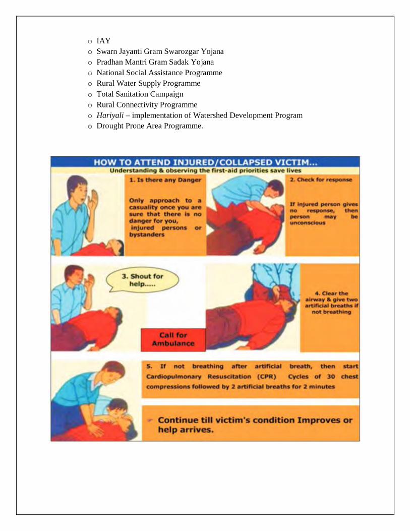
4.1.4. First Aid Team Maintain list of pregnant women, infants, people with special medical needs,
etc. Keeping First-Aid box with disinfectants, antiseptics, ORS, etc. Updated contact number of emergency services i.e. Ambulance, near hospital
public & private. 4.1.5. Relief Management team
To provide relief materials i.e. food, water, cloths, utensils and other essential material for who evacuated and rescued from village.
4.1.6. Shelter Management team Identify safe shelter in village, open spaces for tents installation and nearby
areas in case of evacuate the people from village. 4.1.7. Carcass Disposal Team Identification of space for carcass disposal. Stocking kerosene and fuel for disposal of carcass. Maintaining storage of sackcloth to cover dead bodies of animals. Proper spray of disinfectants (eg: DDT) to keep the air clean
4.1.8. Damage & Need Assessment Team Help in forecasting damages including lives lost and losses to property and
assets such as houses, livestock, agriculture, plantation, etc. Sensitizing families of village to keep their important documents safe, and in
emergency kit. 4.1.9. Reconstruction & Rehabilitation Team Get purified water sources in village.
Prepare reconstruction and rehabilitation plan for vulnerable groups/areas in the village.
4.2. Identify Safe Evacuation Routes
Selection of evacuation route that minimize the exposure to the hazard and other obstacles
Evacuation route to be easily accessible even for vulnerable groups such as, women, children, and elderly. Evacuation Map of the village
4.3. Community level Mitigation Programme Include hazard specific mitigation measures and schemes running in the village
4.3.1. Flood Mitigation Construction of bundhs around settlement. Construction of flood shelter Drainage channels to be cleared Construction of raised platforms near important/ vulnerable areas, such as
school, shelter of animals, gaushalas, etc. 4.3.2. Earthquake Mitigation Detailed survey of buildings for assessment of damage and repair/
reconstruction and seismic strengthening or demolition Training the local masons for constructing earthquake resistant structures Conducting mock drills in villages for evacuation during an earthquake Fix all objects in houses that can fall and cause injury (non structural
mitigation) 4.3.3. Drought Mitigation Continuous drought monitoring through rainfall situation, water availability in
reservoirs, rivers, canals, etc. and comparing with existing water needs of society.
Water conservation through rainwater harvesting in houses and farmers’ fields.
Allowing runoff water from all fields to a common point (eg: pond) or allowing it to infiltrate in the soil where it has fallen.
Generating awareness among the village people on implementing water conservation and agriculture awareness programs through television, pamphlets, nukkad natak, etc.
4.4. Schemes & Disaster Mitigation Identify the schemes/ projects running in the village and segregate them relevant to Mitigation and Preparedness measures. For eg: o Sansad Adarsh Gram Yojana o NREGA
o IAY o Swarn Jayanti Gram Swarozgar Yojana o Pradhan Mantri Gram Sadak Yojana o National Social Assistance Programme o Rural Water Supply Programme o Total Sanitation Campaign o Rural Connectivity Programme o Hariyali – implementation of Watershed Development Program o Drought Prone Area Programme.
Chapter-05
Contact number and Updation of plan
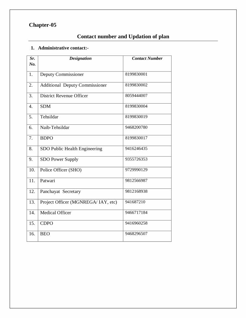
1. Administrative contact:-
Sr.No.
Designation Contact Number
1. Deputy Commissioner 8199830001
2. Additional Deputy Commissioner 8199830002
3. District Revenue Officer 8059444007
4. SDM 8199830004
5. Tehsildar 8199830019
6. Naib-Tehsildar 9468200780
7. BDPO 8199830017
8. SDO Public Health Engineering 9416246435
9. SDO Power Supply 9355726353
10. Police Officer (SHO) 9729990129
11. Patwari 9812566987
12. Panchayat Secretary 9812168938
13. Project Officer (MGNREGA/ IAY, etc) 941687210
14. Medical Officer 9466717184
15. CDPO 9416960258
16. BEO 9468296507
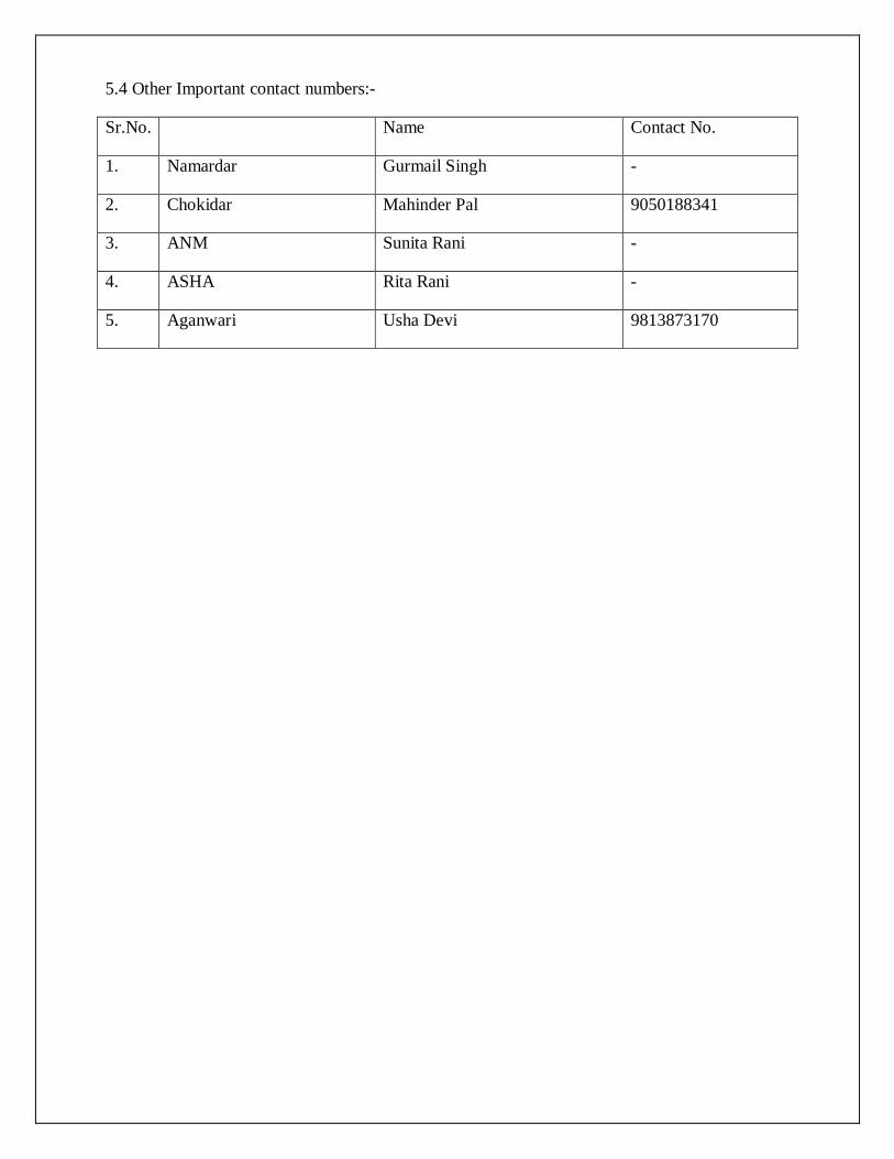
5.4 Other Important contact numbers:-
Sr.No. Name Contact No.
1. Namardar Gurmail Singh -
2. Chokidar Mahinder Pal 9050188341
3. ANM Sunita Rani -
4. ASHA Rita Rani -
5. Aganwari Usha Devi 9813873170