verret_final_grandmontrosedale_23november2014
TRANSCRIPT
Cover
Caitlyn Verret
University of New Orleans
10/1/2014
Farmers' Markets and Community Gardens in Grandmont-Rosedale,
Detroit, Michigan
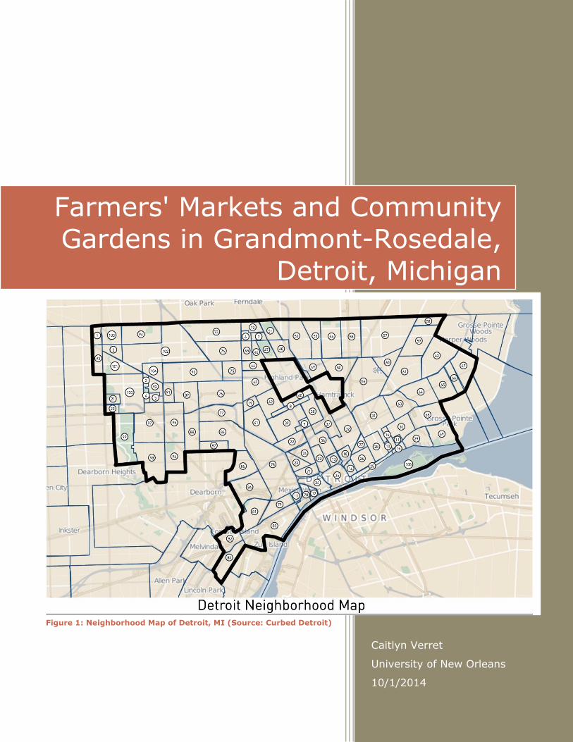
Figure 1: Neighborhood Map of Detroit, MI (Source: Curbed Detroit)

i
Table of Contents
Tables and Figures ........................................................................................ ii
Introduction ................................................................................................. 1
History and Location ..................................................................................... 2
Detroit from the Beginning .......................................................................... 2
Michigan becomes a State ........................................................................... 2
Detroit as a City ........................................................................................ 3
Geography and the Environment ..................................................................... 4
Geography, Climate, and Location ................................................................ 4
Public Parks .............................................................................................. 5
City Government & Public Services .................................................................. 5
City Government and Officials ...................................................................... 5
Public Services .......................................................................................... 6
Police and Fire ........................................................................................ 6
Education ............................................................................................... 7
Transit ................................................................................................... 8
Demographics .............................................................................................. 9
Population................................................................................................. 9
Economy .................................................................................................. 9
Neighborhood and Project Focus Area ............................................................ 10
Introduction to Grandmont-Rosedale .......................................................... 10
History ................................................................................................... 11
Grandmont ........................................................................................... 11
North Rosedale Park .............................................................................. 12
Rosedale Park ....................................................................................... 13
Community Project ................................................................................... 14
Northwest Detroit Farmers' Market .......................................................... 14
Conclusion ................................................................................................. 17
References ................................................................................................ 18
List of Figures ............................................................................................ 23
List of Tables ............................................................................................. 25

ii
Tables and Figures
Table 1: Comparison of Crime-Rate Statistics of Grandmont-Rosedale, Detroit, and
Michigan ...................................................................................................... 6
Table 2: Education Levels of the Residents of Detroit, MI .................................... 7
Figure 1: Neighborhood Map of Detroit, MI ................................................. Cover
Figure 2: City of Detroit; Growth by Annexation from 1806 to 1926 ..................... 1
Figure 3: Location of Detroit, MI, in relation to the US-Canadian Border ............... 2
Figure 4: City of Detroit, MI, in relation to the state of Michigan .......................... 3
Figure 5: Detroit Metropolitan Airport at Night .................................................. 8
Figure 6: Map of The People Mover in Downtown Detroit .................................... 8
Figure 7: Detroit Neighborhood Map with insert of Grandmont-Rosedale
Neighborhood insert .................................................................................... 10
Figure 8: Produce from Northwest Detroit Farmers' Market ............................... 14
Figure 9: Location of Northwest Detroit Farmers' Market; 18445 Scarsdale St. .... 14
Figure 10: Produce and Double Up Food Bucks Acceptance Sign at the Northwest
Detroit Farmers' Market. .............................................................................. 15

1
Introduction
Detroit, Michigan was known to be a thriving city, filled with energy
and hope for those who wanted a fresh start. The city's nicknames, Motor
City and Motown, are both metonyms for the region and could be
synonymous with a booming economy and a great nightlife. This is not true
anymore. With deindustrialization, Detroit fell with the automobile industry.
The city is now in urban decay and the population is at the lowest it has ever
been since about the 1950s.
However, many grassroots
projects are springing up
throughout the city in hopes of
revitalizing their city back to the
greatness it once was. With the
development of farmers'
markets and community
gardens, the residents hope to
bring nature into their city and allow their city to have access to fresh
produce. This paper will start out with information about Detroit before going
into the Grandmont-Rosedale neighborhood and their local farmers' market,
the Northwest Detroit Farmers' Market.
Figure 2: City of Detroit; Growth by Annexation from 1806 to 1926 (Source: Detroit Firemen's Fund Association)

2
History and Location
Detroit from the Beginning
Located on the Detroit River and was
founded by French explorer Antoine de la
Monthe Cadillac as a fort in 1701, Detroit
was previously protected from non-traders
because of the importance of commerce
from the local Native American tribes. However, he only stayed as an outpost
commander for nine years before Cadillac was removed from his post by the
French government due to excessive lining of his own wallet – or officially,
“ill conduct”. Cadillac then becomes the governor of a French colony in
Louisiana, never returning to Detroit. By 1747, tension was high between
the French and the British. Each had Natives that were loyal to each side and
the French sent troops to Detroit from Montreal to strengthen against the
British's native allies, the Huron Indians. Seven years later, the French and
Indian War began. The French deployed over 400 troops to Detroit, a major
stronghold for the war. The British Major and his troops seized Detroit in
1760 and as part of the treaty at the end of the war, the British kept Detroit
(Timeline of Detroit).
Michigan becomes a State
Britain’s thirteen colonies gained independence as the United States of
America; however, Detroit remained under British rule. On September 3,
Figure 3: Location of Detroit, MI, in relation to the US-Canadian Border
(Source: Screenshot of Google Maps, 2014)

3
1783, Michigan became a part of the
United States. The British refused to
surrender the forts in Detroit. The
Northwest Territory was created by the
Continental Congress, composed of 12 of
the original 13 colonies, in 1787. It was
comprised of the future states of Ohio,
Indiana, Illinois, Michigan, Wisconsin and
some of Minnesota. Even after adopting
a fire code in 1802 that required all
residents and business owners to sweep
their chimneys and providing buckets and ladders to residents to fight any
and all fires, most of Detroit was destroyed in a fire three years later. The
Territorial Governor and Judge, William Hull and Augustus Woodward
respectively, decided to build a planned community based on the design of
Washington, D.C., the nation's new capital (Timeline of Detroit).
Detroit as a City
In 1815, Detroit was incorporated as a city. It now had many
churches, businesses, shops, and schools. It also had a university which
became present day University of Michigan. Finally, on January 26, 1837,
Michigan became the 26th state of the United States and Detroit was its first
capital. By the late 1800s, manufacturing was Detroit's biggest industry.
Figure 4: City of Detroit, MI, in relation to the state of Michigan (Source: Screenshot of Google Maps, 2014)

4
Cars, heating and cooking stoves were the biggest industries at the time, but
ship building, cigars and tobacco, pharmaceuticals, beer, rail cars, and
foundry and machine shop products were other main industries of Detroit as
there were major improvements of shipping throughout the states by this
time.
Henry Ford built his first car in Detroit, which was not a huge event,
but the method of building cars was: the moving assembly line. Because of
this discovery, it put the production edge on winning World War II (Timeline
of Detroit).
Geography and the Environment
Geography, Climate, and Location
The metro area includes four main bodies of water: Detroit River, St.
Clair River, Lake St. Clair, and the west end of Lake Erie. There are four
distinct seasons: winter has an average snowfall around 45 inches while
during the summer, storms usually pass to the north, which allows for
intervals of warm weather with occasional thunderstorms and mild, dry
weather. The land is nearly flat, becoming a rolling terrain north-westward
from the waterways (Detroit: Geography and Climate). The city of Detroit is
593 feet (about 181 meters) above sea level while the geographic
coordinates are 42° 19' 53'' N and 83° 02' 44'' W (Date and Time).

5
Public Parks
There is one Michigan State park in Detroit: Belle Isle Park. It has been a
state park since the beginning of the 2014 year. It consists of 982-acres on the
Belle Isle island. Under the 30-year lease agreement, the City of Detroit maintains
ownership of the park while the state government, the Michigan Department of
Natural Resources, manages the island and upkeep. During the first year, there was
an $11 annual fee to the residents of Detroit, which allows entry into all state
parks. This fee does not apply to those who travel into the park by foot or bicycle.
This park holds the title of being America's largest city-owned island park.
This island was purchased in 1897 for $200,000, keeping the name Belle Isle
(beautiful island). The city founders bought this despite opposition of the price
being too high. In 1883, Frederick Law Olmstead, the designer of New York City's
Central Park, created a master plan for the development of Belle Island. Finally, in
1889, a wooden bridge was built, allowing for the park's first visitors (2014, Belle
Isle | Recreation Department).
City Government & Public Services
City Government and Officials
Mike Duggan, a Detroit-native, is the current mayor. He was elected on
November 5, 2013 and took office on January 1, 2014. There is also a city
council that consists of nine members (2014, About Mayor Duggan). Both
the mayor and the nine city council members are elected in four-year terms.
It replaced the Board of Trustees in the city in 1824 and was called the

6
Common Council until Detroit's new city charter went into effect on July 1,
1974 (2014, About City Council).
Public Services
Police and Fire
Crime in the
City of Detroit is
grim with a rating
of F on the website
Area Vibes. For the
Grandmont-
Rosedale neighborhood, the estimated crime index is 15% lower than the
Detroit average; however, the Detroit crime index is 177% higher than the
Michigan average. There are a total of 3,401 police officers, averaging out to
about 4 officers per 1,000 residents in the city of Detroit, which is 70.4%
greater than the Michigan average. The Grandmont-Rosedale neighborhood,
the focused neighborhood featured later in this document, is safer than 70%
of the neighborhoods in Detroit. The estimated chance of being a victim of
any crime in Grandmont-Rosedale is 1 in 13, while the chance of being a
victim of a violent crime is 1 in 45 (Grandmont-Rosedale, Detroit, MI Crime
Rates & Statistics).
Statistic Grandmont-
Rosedale/100k
Detroit/100k Michigan
/100k
Violent Crime 1,789 (estimate) 2,137 455
Property Crime 5,167 (estimate) 6,144 2,531
Total Crime
Index
6,964 (estimate) 8,281 2,985
Table 1: Comparison of Crime-Rate Statistics of Grandmont-
Rosedale, Detroit, and Michigan (Source: Grandmont-Rosedale, Detroit, MI Crime Rates)

7
Education
In Detroit, there are a total of 336 public schools, 64 private schools, and 19
post-secondary schools. The student teacher ratio is 23:1 which is 2.3% greater
than the Michigan average of 22:1. Only 73.1% of the residents of Detroit have
completed 8th grade and only 69.6% of Detroit residents have completed high
school. Furthermore, 31.5% of males and 28.8% of females have received a high
school diploma while 6.2% of males and 7.3% of females earned a Bachelor's
degree (Detroit, MI Education).
73.1
69.6
39.6
16.1
11
4.2 1.2 0.4
Education Level Achieved in Detroit
8th Grade
High School
Some College
Associate Degree
Bachelor's
Master's
Professional Degree
Doctorate
Table 2: Education Levels of the Residents of Detroit, MI (Source: Detroit, MI Education)

8
Transit
The Detroit Metropolitan Airport is Detroit's only airport; however, it's
technically located in the suburbs of Detroit. There are a total of 6 runways and 145
gates that are divided between two passenger terminals. The Detroit Metro Airport
is ranked 18th in North America for number of passengers in 2012 and ranked 12th
in North America for number of
aircraft operations (2012, Detroit
Metropolitan Airport, Facts). The
average travel time to work in
Detroit (31 minutes) is 29.2%
greater than the Michigan average
(24 minutes) (Detroit, MI
Transportation). There is a tram
system in Downtown Detroit with a
total of 13 stops that are looped around important areas, such as the Detroit Opera
House and the General Motors Global Headquarters. It is appropriately named the
People Mover (The Detroit People Mover). Based on the Area Vibe data, which was
originally gathered by the census data for 2012, approximately 71% drive as their
Figure 5: Detroit Metropolitan Airport at Night (Source: Detroit Metropolitan Airport, Traveler Info)
Figure 6: Map of The People Mover in Downtown Detroit (Source: The Detroit People Mover, 2012)

9
means of transportation while about 12% carpool. Public transportation makes up
about 9% (Detroit, MI Transportation).
Demographics
Population
The total population as of the 2010 Census for Detroit was 713,777.
There was a decline of 24.97% compared to the 2000 Census of 951,307.
There were 376,098 females according to the 2010 Census of Detroit --
about 52.69% -- while there were 337,579 males -- 47.31%. The majority
of residents were black: as of the latest census, there were 590,226 that
claimed Black or African American alone -- a total of 82.69% of the
population (Detroit, Michigan Population).
Economy
The cost of living is 12.6% less than the Michigan average. The cost
of a gallon of gas is about $3.84, 6.0% higher than the national average.
Based on 2010 estimates, the median household income was $25,357.
Median household income that was owner occupied was $46,037 and median
household income that was renter occupied was $24,225. (Detroit, MI Jobs,
Unemployment Rates & Median Household Income). Owner occupied housing
was at 56.8% while 43.2% of housing was renter occupied, with the median
rent at $747 (Detroit, MI Housing Prices & Real Estate Data). 26.1% of
Detroit was at poverty level or worse. In 2010, the unemployment rate was

10
at 24.8% but had decreased to an estimated 9.8% in 2013. The two top
industries in Detroit are the Education, Health, and Social Services sector
and the Manufacturing sector (Detroit, MI Jobs, Unemployment Rates &
Median Household Income).
Neighborhood and Project Focus Area
Introduction to Grandmont-Rosedale
Blight is a major issue of Detroit and there are many programs throughout
the city that focus on recycling land lots to prevent the 'broken window' effect. The
broken window theory (effect) is the idea that maintaining and monitoring the
urban setting will prevent vandalism, which will prevent the growing of more
Figure 7: Detroit Neighborhood Map with insert of Grandmont-Rosedale Neighborhood insert (Edited) (Source: Curbed Detroit)

11
serious crime. The community that will be focused on is the Grandmont-Rosedale
neighborhood. They transformed the empty lots into community garden lots, which
in turn allows many to make an income in an otherwise economically poor city
(Farmers' Market, Grandmont Community Development Corporation).
History
Located in the northwest corner of Detroit, it consists of five smaller
neighborhoods: Grandmont, Grandmont #1, Minock Park, North Rosedale Park,
and Rosedale Park. Each has at least one neighborhood association, providing help
to the residents to the sub-neighborhood. The Detroit Neighborhood Map has been
provided again, with an insert of the Grandmont-Rosedale neighborhood added. The
location of each sub-neighborhood is follow: Grandmont #1 - 5; Minock Park - 3;
Grandmont - 91; Rosedale Park - 92; and North Rosedale Park - 104. The
Grandmont-Rosedale neighborhood district contains more than 5,000 homes within
its 2.5 square mile area (My Grandmont Rosedale). Following this section will be
history of the three larger neighborhoods: Grandmont, North Rosedale Park, and
Rosedale Park.
Grandmont
The Grandmont area became a part of Detroit officially in 1923 and is rich in
history. It originally was deeded to Thomas Norton in 1835 by Andrew Jackson, the
area estimated about 80 acres. The David family bought 40 acres of that in 1880
for $300,000, then in 1915, the Grand River Development Company paid $16
million to Victorine David for the same 40 acres.

12
Many of the structures built in the late 1890s still stand: on the corner of
Rutland and Schoolcraft is the original farmhouse of the Davids. Mrs. Boyland
David, the original occupant, refused to sell the farmland to the developers unless
they planted maple trees on both sides of the street. The maple trees still stand
there today. However, many of the trees in the Grandmont area are much older
than the subdivision because much of the area was wooded when the area was built
up: they were left there as a cosmetic aspect to potential buyers.
By 1916, the subdivision was divided into plots and the area grew with new
residents. All 800 lots were soon filled with houses with many different architectural
designs and by 1927, a homeowners association was formed to help preserve the
original structures and improve their surrounding areas (Grandmont Community
Association.)
North Rosedale Park
In the early 1920s, this area was built up to become a subdivision. The sales
slogan for the area was "Out of the Smoke Zone - Into the Ozone," created by the
Rosedale Park Land Company. The slogan worked very well for the company and
soon the empty lots were filled with houses. Many of the new families were the
Herberts, Smiths, Judsons, Seiberts, and Browns, to name a few. Elms follow the
streets, much like maples in the Grandmont area.
After the lots were sold, the developers withdrew and soon the residents
found themselves with many problems. They quickly developed a unity to fight
against problems such as transportation needs. The residents pooled together their
resources in a communistic manner and soon, Rosedale automobiles were available
for Rosedale needs. The park became a center of attraction for the residents of this

13
neighborhood and soon an informal organization was created in the fall of 1923.
Finally, in early fall 1924, the North Rosedale Park Civic Association was created
(North Rosedale Park Civic Association.)
Rosedale Park
Much like the Grandmont area, Andrew Jackson deeded 80 acres of land to
Mr. Otis Freeman in October of 1835, while in November of the same year, 40 acres
was deeded to Mr. George Bellamy. For about the next 75 years, land ownership
changed hands. It wasn't until 1916 that the Rosedale Park Land Company
purchased a portion of it and started creating lots for development. This area was
also advertised with the slogan "Out of the Smoke Zone - Into the Ozone." The
Barkley family, with their infant son, were the first residents of Rosedale Park.
Grand River Avenue was a quiet barrier between North Rosedale Park and Rosedale
Park, creating a separate community even though they were both developed by the
same company. For the residents in this sub-neighborhood, fire protection was the
biggest concern:
The neighborhood stored a manual drive fire hose in a shed on Glastonbury.
By posting a cash bond with the City of Detroit, the City would send fire
trucks if needed, after which it would be necessary to gather more
subscriptions for a new bond. This was one of the original reasons for
organizing the Rosedale Park Improvement Association (History of Rosedale
Park).
14
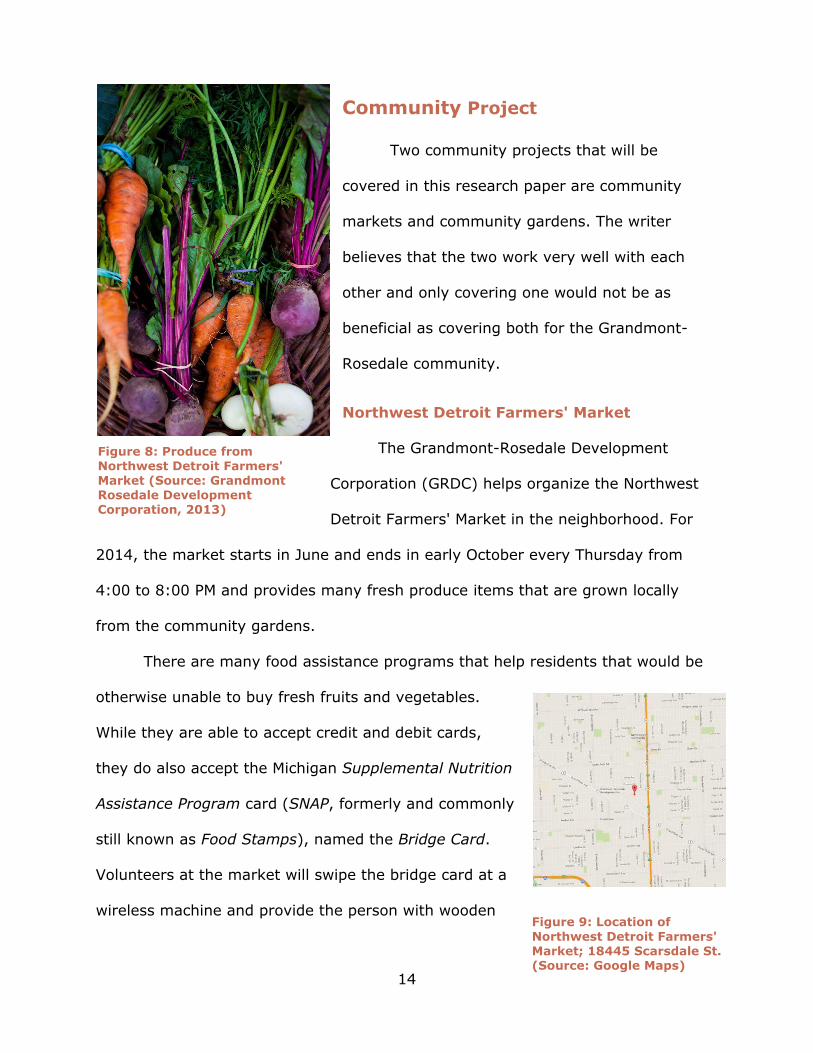
Community Project
Two community projects that will be
covered in this research paper are community
markets and community gardens. The writer
believes that the two work very well with each
other and only covering one would not be as
beneficial as covering both for the Grandmont-
Rosedale community.
Northwest Detroit Farmers' Market
The Grandmont-Rosedale Development
Corporation (GRDC) helps organize the Northwest
Detroit Farmers' Market in the neighborhood. For
2014, the market starts in June and ends in early October every Thursday from
4:00 to 8:00 PM and provides many fresh produce items that are grown locally
from the community gardens.
There are many food assistance programs that help residents that would be
otherwise unable to buy fresh fruits and vegetables.
While they are able to accept credit and debit cards,
they do also accept the Michigan Supplemental Nutrition
Assistance Program card (SNAP, formerly and commonly
still known as Food Stamps), named the Bridge Card.
Volunteers at the market will swipe the bridge card at a
wireless machine and provide the person with wooden
Figure 8: Produce from Northwest Detroit Farmers' Market (Source: Grandmont Rosedale Development Corporation, 2013)
Figure 9: Location of
Northwest Detroit Farmers' Market; 18445 Scarsdale St. (Source: Google Maps)

15
tokens that are accepted by all vendors in the market. Just like at any retail store,
however, it must be a SNAP-eligible food item (Farmers’ Market, Grandmont
Community Development Corporation).
The Double UP Food Bucks program works in conjunction of the SNAP
program. It also works on a system of tokens, only slightly different in design. For
every two dollars you spend at the farmers' market, the program matches you two
dollars up to $20, for a complete total of $40 dollars (Farmers Market, Grandmont
Community Association) . It's a great incentive to shop local and fresh.
Seniors are eligible to receive coupons at the market as well. Through the
Senior Farmers' Market Nutrition Program, commonly known as Senior Project
FRESH, senior citizens of Michigan are able to
receive fresh Michigan products from farmers'
markets and roadside stands throughout the
state. This program was founded under the
U.S. Department of Agriculture funding and
benefits both farmers and seniors. Both Senior
Project FRESH and WIC Project FRESH are
redeemable as coupons instead of tokens that
are used for the Double UP program.
These projects were started in 1986 in
several states, but it wasn't until 1988 that
Congress allowed for a three year
demonstration of the program in 10 states.
After the success of the trial, the WIC Farmers'
Figure 10: Produce and Double Up Food Bucks Acceptance Sign at the Northwest Detroit Farmers' Market.
(Source: Northwest Detroit Farmer’s Market Facebook Page)

16
Market Nutrition Act of 1992 was enacted. On June 1, 1993, the program was
transferred from the Michigan Department of Agriculture after a two-year hiatus to
the Michigan Department of Community Health, where it still remains as of 2014.
The WIC Project FRESH consisted of $449,436 in federal fundings and $61,675 in
other fundings such as local, private, and WIC program income for the fiscal year of
2011. Each participant receives fifteen $2 coupons, a total of $30, to use for the
programs fiscal year that starts on June 1st (Project FRESH - Farmers' Market
Nutrition Program).
All the programs used at farmers’ markets are to help the financially
disadvantaged in Detroit. If blighted lots were recycled into garden lots and into
permanent farmers’ markets, this would reduce the amount of blight within the city
of Detroit while helping the residents in an economically turmoil region. "In fact, the
popularity of green markets is pervasive: the number of farmer's markets in the
United States doubled between 2001 and 2011 (Garvin, 2014, p. 91)." The growth
of the number of farmers' markets is a noticeable trend for the US; it was only a
matter of time that a heavily blighted city such a Detroit would find use for the
empty lots for farmers' markets and community gardens.
With the development of public, open-air pavilions for farmers’ markets,
there is the ability to allow lots to be used by the public for social gatherings like
birthday parties and barbeques for family, friends, and organizations. Also, if there
is enough room, there could be room for a playground for the children who attend
events with their families or who live nearby. If the lot is turned into a community
garden, it would allow the farmers to keep the produce for personal use, trade with
other farmers for produce they do not have, or sell their produce at the farmers’

17
markets for income. This is all to help those who are low-income residents of the
city, both farmers and shoppers alike, with receiving fresh produce – for the
shoppers – and to receive an income – for the farmers. This does not necessarily
only need to happen in the Grandmont-Rosedale neighborhood, it could be applied
to Detroit as a whole; however, it could also be applied to any heavily blighted city
such as New Orleans, Louisiana, or Baltimore, Maryland, both of which are known
to have high levels of blight (Wiggins, 2014).
Conclusion
Through the efforts of the residents of Grandmont-Rosedale neighborhood,
the uprising of famers' markets and community gardens to bring nature into the
city and to provide fresh produce to the residents of the area is a work in progress.
For Detroit, however, blighted lots need to be recycled into usable, diverse areas -
not every lot should be strictly pavilions for farmers' markets or strictly community
garden lots. These lots will have better diverse development potential, such as
development for hospitals or public housing projects. Only with an assortment of
use will the city of Detroit grow into the thriving city that it was once known to be.

18
References
City of Detroit. (2014). About City Council. Retrieved September 5, 2014, from
http://www.detroitmi.gov/CityCouncil/AboutCityCouncil/tabid/2633/Default.
aspx
City of Detroit. (2014). About Mayor Duggan. Retrieved September 5, 2014, from
http://www.detroitmi.gov/DepartmentsandAgencies/MayorsOffice/AboutMay
orDuggan.aspx
City of Detroit. (2014). Belle Isle| Recreation Department. Retrieved October 6,
2014 from http://www.detroitmi.gov/DepartmentsandAgencies/Recreation
Department/BelleIsle.aspx
Corktown History: A Guide to Researching Your Corktown Home. (n.d). Corktown
History: A Guide to Researching your Corktown Home Retrieved. September
5, 2014, from http://cortownhistory.blogspot.com/2012/03/guide-to-
researching-your-corktown-home.html
Curbed Detroit. (2013, August 20). Finally, a Complete Attempt at Mapping
Detroit's Neighborhoods. Retrieved September 5, 2014, from
http://detroit.curbed.com/archives/2013/08/finally-a-complete-attempt-at-
mapping-detroits-neighborhoods.php
Date and Time. (n.d). Geographic Coordinates of Detroit, Michigan, USA. Retrieved
October 1, 2014 from
http://dateandtime.info/citycoordinates.phpid=4990729
Detroit Firemens Fund Association: The Official Clothing Store of the Detroit Fire
Department RSS. (n.d.). Why Did We Name Our Blog The Slate?. Retrieved
September 23, 2014, from http://www.detroitfiremensfund.com/why-the-

19
slate/
Detroit: Geography and Climate. (n.d.). Detroit: Geography and Climate. Retrieved
September 5, 2014, from http://www.city-data.com/us-cities/The-
Midwest/Detroit-Geography-and-Climate.html
Detroit Historical Society. (n.d.). Timeline of Detroit. Retrieved September 5, 2014,
from http://detroithistorical.org/learn/timeline-detroit
Detroit Metropolitan Airport. (2012). Facts. Retrieved October 23, 2014 from
http://www.metroairport.com/TravelerInfo/GeneralInfo/AboutDTW/Facts.as
px
Detroit Metropolitan Airport. (2012). Traveler Info. Retrieved October 23, 2014
from http://www.metroairport.com/TravelerInfo.aspx
Detroit, MI Education – Public Schools, Colleges & Universities. (n.d.). Detriot, MI,
Education. Retrieved October 1, 2014 from http://www.areavibes.com/
detroit-mi/education/
Detroit, MI Housing Prices & Real Estate Data. (n.d.). Detroit, MI Housing Prices &
Real Estate Data. Retrieved October 1, 2014 from
http://www.areavibes.com/detroit-mi/housing/
Detroit, MI Jobs, Unemployment Rates & Median Household Income. (n.d.). Detroit,
MI Jobs Unemployment Rates & Median Household Income. Retrieved
October 1, 2014 from http://www.areavibes.com/detroit-mi/employment/
Detroit, MI Population. (n.d.). Detroit, Michigan Population: Census 2010 and 2000
Interactive Map, Demographics, Statistics, Quick Facts. Retrieved September
5, 2014, from http://censusviewer.com/city/MI/Detroit
Detroit, MI Transportation. (n.d). Detroit, MI Transportation. Retrieved October 1,

20
2014 from http://www.areavibes.com/detroit-mi/transportation/
Detroit, MI 1st Map. (2014). Google Maps. Google. Retrieved on September 25,
2014 from
https://www.google.com/maps/place/Detroit,+MI/@43.6468852,-
83.5664672,6z/data=!4m2!3m1!1s0x8824ca0110cb1d75:0x5776864e35b9c
4d2
Detroit, MI: 2nd Map. (2014). Google Maps. Google. Retrieved on September 25,
2014 from
https://www.google.com/maps/place/Detroit,+MI/@43.7858454,-
84.6486205,7z/data=!4m2!3m1!1s0x8824ca0110cb1d75:0x5776864e35b9c
4d2
Detroit People Mover, The. (2012). Station Guide. Retrieved October 23, 2014 from
http://www.thepeoplemover.com/Station-Guide.id.3.htm
Garvin, A. (2014). The American City: What Works, What Doesn't (Third ed.).
McGraw Hill Education.
Grandmont Community Association. (n.d.). Farmers' Market. Retrieved October 6,
2014 from http://www.grandmontrosedale.com/programs/farmers-
market.html
Grandmont Community Association. (n.d.). About Us. Retrieved October 6, 2014
from http://www.grandmontcommunity.com/aboutus.html
Grandmont-Rosedale Development Corporation. (n.d.). Farmers' Market Features
Fresh Food and Fun. Retrieved September 5, 2014, from
http://www.grandmontrosedale.com/programs/farmers-market.html
Grandmont-Rosedale, Detriot, MI Crime Rates & Statistics. (n.d.). Grandmont-

21
Rosedale, Detroit, MI Crime Rates & Statistics. Retrieved September 25,
2014, from http://www.areavibes.com/detriot-mi/grandmont-
rosedale/crime/
Grandmont-Rosedale Development Corporation. (2013, October 13). Facebook
Page. Retrieved September 25, 2014 from
https://www.facebook.com/GrandmontRosedaleDevelopment/photos/a.1015
0094753874790.279652.152693679789/10151747189679790/?type=1&per
mPage=1
My Grandmont Rosedale. (n.d). Neighborhoods - My Grandmont Rosedale.
Retrieved October 6, 2014 from
http://mygrandmontrosedale.org/neighborhoods/
Northwest Detroit Farmers’ Market Facebook Page. (2013, September 26).
Facebook. Retrieved November 18, 2014 from
https://www.facebook.com/nwdetroitfarmersmarket/photos/a.21974453473
2489.57669.208320499208226/671384016235203/?type=1&permPage=1
Northwest Detroit Farmers' Market Map Location. (2014). Google Maps. Retrieved
October 24, 2014 from https://www.google.com/maps/place
/42%C2%B024'26.4%22N+83%C2%B013'24.5%22W/@42.4082936,-
83.2214794,14z/data=!4m2!3m1!1s0x0:0x0
North Rosedale Park Civic Association. (n.d.). The Neighborhood. Retrieved October
6, 2014 from http://northrosedalepark.org/about/neighborhood/
Rosedale Park Improvement Association. (n.d.). History of Rosedale Park. Retrieved
October 6, 2014 from http://www.rosedalepark.org/index.php/2013-03-21-
02-09-31/history

22
Wiggins, T. (2012, August 23). New Orleans No Longer Most Blighted U.S. City:
Detroit and Flint, Mich., Come Out on Top – AOL Real Estate. Retrieved
November 18, 2014 from http://realestate.aol.com/blog/2012/08/23/new-
orleans-no-longer-most-blighted-u-s-city-detroit-and-flint/

23
List of Figures
Figure 1: Neighborhood map of Detroit, MI,
http://detroit.curbed.com/archives/2013/08/finally-a-complete-attempt-at-
mapping-detroits-neighborhoods.php
Figure 2: City of Detroit; Growth by Annexation from 1806 to 1926, http://www.
detroitfiremensfund.com/why-the-slate/
Figure 3: Location of Detroit, MI, in relation to the US-Canadian Border, https://
www.google.com/maps/place/Detroit,+MI/@43.6468852,-83.5664672,6z/data=
!4m2!3m1!1s0x8824ca0110cb1d75:0x5776864e35b9c4d2
Figure 4: City of Detroit, MI, in relation to the state of Michigan, https://www.
google.com/maps/place/Detroit,+MI/@43.7858454,-84.6486205,7z/data=!4m2
!3m1!1s0x8824ca0110cb1d75:0x5776864e35b9c4d2
Figure 5: Detroit Metropolitan Airport at Night,
http://www.metroairport.com/Traveler
Info.aspx
Figure 6: The People Mover in Downtown Detroit, http://www.thepeoplemover.com
/map_interactive.html
Figure 7: Detroit Neighborhood Map with insert of Grandmont-Rosedale
Neighborhood insert (Edited) http://detroit.curbed.com/archives/2013/08/finally-a-
complete-attempt-at-mapping-detroits-neighborhoods.php
Figure 8: Produce from Northwest Detroit Farmers’ Market,
https://www.facebook.com
/GrandmontRosedaleDevelopment/photos/a.10150094753874790.279652.1526936
79789/10151747189679790/?type=1&permPage=1

24
Figure 9: Location of Northwest Detroit Farmers' Market; 18445 Scarsdale St.,
https://www.google.com/maps/place/42%C2%B024'26.4%22N+83%C2%B013'24.
5%22W/@42.4082936,-83.2214794,14z/data=!4m2!3m1!1s0x0:0x0
Figure 10: Produce and Double Up Food Bucks Acceptance Sign at the Northwest
Detroit Farmers' Market, https://www.facebook.com/nwdetroitfarmersmarket
/photos/a.219744534732489.57669.208320499208226/671384016235203/?type=
1&permPage=1

25
List of Tables
Table 1: Comparison of Crime-Rate Statistics of Grandmont-Rosedale, Detroit, and
Michigan, http://www.areavibes.com/detroit-mi/grandmont-rosedale/crime/
Table 2: Education Levels of the Residents of Detroit, MI, http://www.areavibes
.com/detroit-mi/education/