vegetation, soils and management of ‘zara’: a sandhill
TRANSCRIPT
Vegetation, soils and management of ‘Zara’: a sandhill remnant on the Riverine Plain
M.J. Stafford and D.J. Eldridge
Stafford, M.J.1,3 and Eldridge, D.J2. (1School of Geography, University of NSW, Australia 2052. 2Department of Land and Water Conservation, Centre for Natural Resources, c/- School of Geography, University of NSW, Australia 2052. 3Current address: Australian Water Technologies, 51 Hermitage Rd, West Ryde, NSW, 2114, Australia) 2000. Vegetation, soils and management of ‘Zara’: a sandhill remnant on the Riverine Plain. Cunninghamia 6(3): 717–746. The ‘Zara’ exclosure (approximately 35°10'21''S, 144°41'59''E) is on a source-bordering dune on the Riverine Plain north of Deniliquin. The vegetation of this sandhill closely represents the original vegetation that once covered sandhills of the south-west Riverina prior to European occupation. Three vegetation communities comprising six associated Map Units were defined by cluster analysis within the 60 ha exclosure. These were the Callitris Mixed Woodland (Map Units 1, 2, 3, and 6), the Black Box Woodland (Map Unit 5) and the White-top Grassland (Map Unit 4). Seventy-seven taxa were recorded during the survey, and the vegetation was dominated by species from the families Chenopodiaceae and Poaceae. Three shrubs, the exotic weed Lycium ferocissimum and the natives Rhagodia spinescens and Enchylaena tomentosa occurred at more than 75% of sites. The distribution of vegetation communities was strongly associated with attributes of the soil (e.g. soil texture and organic carbon) and plant and litter cover. Vegetation communities occupying remnant sandhills such as the ‘Zara’ exclosure are some of the most vulnerable communities on the Riverine Plain.
Introduction
Sandhill remnants scattered across the Riverine Plain support restricted and vulnerable plant communities. Their small size, narrow shape and distance from other natural areas render them vulnerable to weed and pest invasion, and continued disturbance by livestock and feral herbivores. Grazing and disturbance and clearing and cultivation for agriculture result in declining recruitment and/or higher mortality of understorey species, and eventually loss of native vegetation cover (Porteners 1993). These sandhill remnants are becoming increasingly valuable for the survival of diminishing plant communities and their associated species (Eardley 1999). Maintenance of these sandhills as ‘conservation islands’ within a modified landscape depends on our knowledge of the current pressures and threats to these communities.
Only a few remnants, including the ‘Zara’ exclosure, closely represent the vegetation that once covered the sandhills of the south-west Riverina prior to European occupation.
The ‘Zara’ source-bordering dune (sandhill), has been recognised for its high biodiversity and conservation value. Brickhill (1985) recommended that the Callitris-dominated community at ‘Zara’ be given high conservation priority, and Porteners (1993) subsequently recommended that regeneration of the site be initiated. The Southern Riverina Naturalists also recognised the conservation value of the ‘Zara’
717

sandhill, and it was eventually fenced off from surrounding grazing land in May 1997. The fencing of the 60 ha sandhill site was supported by station owners F.S. Falkiner and Sons, with funding provided through the Drought Landcare Program of New South Wales National Parks and Wildlife Service. Greening Australia, Conservation Trust Volunteers, Windouran Shire Council and the Deniliquin Rural Lands Protection Board also provided support.
Previous work on vegetation communities on sandy soils on the Riverine Plain has been limited to species inventories, or general discussions of the sandhills in the context of the plain. Little is known about the relationships between plants and soils on these sandhill remnants, and there has been no attempt to quantitatively describe the links between the structure of the communities and the components of the soils and landforms.
Broad regional studies, species lists, management and technical reports, rangeland reviews and literature surveys have been undertaken by the Soil Conservation Service of NSW (Department of Land and Water Conservation), the National Herbarium of NSW, and by individuals such as Moore (1953), Leigh and Mulham (1977) and Cunningham et al. (1981). Porteners (1993) mapped the vegetation of the ‘Hay Plain’ which covered an area of 4.5 million hectares at a scale of 1: 250 000. Benson et al. (1997) also provide a recent and detailed description of the grasslands of the Riverine Plain.
The objective of this study was to describe the vegetation and soils, and their interrelationships, within the ‘Zara’ exclosure, and to provide base-line information against which future changes to the vegetation and soils could be compared. The ultimate aim is to provide objective information on which to support the management of the exclosure.
Study area
The study site is located on the Riverine Plain in south-western New South Wales. The Plain is a large expanse of flat alluvial landscape bordered by Narrandera and Balranald, and Ivanhoe and Bendigo. The exclosure is located within ‘Zara’, a grazing property located approximately 40 km north of Deniliquin, or 10 km east of Wanganella (35°10'21''S, 144°41'59''E) (Fig. 1). The principal land use in the area is sheep grazing on native pastures. The surrounding vegetation is typical of the Riverine Plain with annual grasses such as barley grass (Hordeum leporinum) and ryegrass (Lolium rigidum) comprising substantial proportions of the pasture. Smaller areas are used for irrigation and dryland cropping.
Isolated sandhills supporting the Callitris glaucophylla assemblage occur throughout the region. Those that occur within State Forests, as well as being subject to logging, are often leased out to landholders, and suffer intensive grazing pressure with little or no generation of tree species (Porteners 1993).
While the ‘Zara’ exclosure is by far the best remaining example of the Callitris-dominated community present in the region, it cannot be considered pristine. ‘Zara’ has been managed as a typical sheep grazing property for the past 150 years. The homestead is located approximately 500 m west of the sandhill, and consequently the
718 Cunninghamia Vol. 6(3): 2000

sandhill would have formed part of the horse paddock surrounding the homestead. Grazing by sheep and cattle would have been intermittent, probably for short periods, as most managers tried to encourage a buffer strip around their homesteads to lessen the impact of dust storms. Ms Officer, the wife of one of the owners in the early part of the century was a keen naturalist, and collected many plant species from the sandhill. Some of her collection is housed at the National Herbarium of NSW. In the 1930s and 1940s the sandhill was apparently used as a golf course, suggesting that shrub cover would have been much less than it is today. Fencing, to exclude rabbits and domestic animals but not kangaroos, was carried out in 1997 using rabbit-proof netting.
The importance of the ‘Zara’ exclosure cannot be underestimated for several reasons. The exclosure, as well as officially recognising the conservation importance of the sandhill vegetation, encourages future and longitudinal studies of this sandhill. There is already evidence that the rabbit- and sheep-proof fencing has enhanced the regeneration of tree species such as rosewood (Alectryon oleifolius) and sugarwood (Myoporum platycarpum). Fencing has also enabled the Riverina Field Naturalists to strategically control african boxthorn (Lycium ferocissium) within the exclosure and within a buffer strip around the exclosure. Rabbit control has also been initiated with the use of 1080 baiting and warren ripping.
Stafford and Eldridge, ‘Zara’ sandhill remnant, Riverine Plain 719
Fig. 1. Location of the ‘Zara’ exclosure in south-western New South Wales (adapted from Semple 1990).
Climate
The climate of the Riverine Plain can be classified as semi-arid, with very hot summers, mild winters and a winter dominant rainfall (Edwards 1979). For the months of January and February, the average daily maximum is approximately 32°C and the average daily minimum for July is about 4°C for the whole of the Riverine Plain (O’Halloran 1995). ‘Wanganella’, east of ‘Zara’, has a mean annual rainfall of 337 mm and an average of 53 rain days (Bureau of Meteorology 1998). January and February are the driest months at ‘Wanganella’, while peak rainfall occurs in May and September (Benson et al. 1997).
Evaporation rates are high, especially in summer and autumn when rainfall is largely ineffective (O’Halloran 1995). Frosts are common between May and September (Cunningham et al. 1981). The most common wind directions are from the south and south-east, although in winter and spring a westerly influence is common. Wind is an important factor in the formation of landforms such as sand dunes which are common on the Riverine Plain.
Landforms and soils
The area surrounding the ‘Zara’ sandhill consists mostly of alluvial and lacustrine deposits of clay, silt, sand and gravel (Semple 1990). Geomorphically, the sandhill can be described as a source-bordering sandhill which has been derived from the redistribution of coarse stream bed deposits of prior streams and, to a lesser extent, ancestral rivers (Butler et al. 1973). The sandhill is gently sloping, orientated west-east, and was stabilised by vegetation prior to European settlement.
The soils of the ‘Zara’ sandhill consist of a mixture of siliceous and earthy sands which have a relatively uniform profile with only small changes in colour and texture with depth (Eldridge 1990). The sands are also low in fertility and are highly susceptible to wind erosion once the stabilizing vegetation is removed. Red and brown texture contrast (duplex) soils occur at the margin of the sandhill and the plain. Their surface textures are generally coarse sandy to loamy sands, grading to clayey subsoils often with carbonate at depth. Texture contrast soils are susceptible to windsheeting and scalding (Eldridge 1990).
Vegetation
Much of the Riverine Plain, particularly in the western section, supports chenopod shrubland dominated by Atriplex vesicaria and Maireana aphylla, and to a lesser extent Atriplex nummularia (Porteners 1993). To the east this shrubland has been replaced by a grassland dominated by Notodanthonia caespitosa and other perennial and annual grasses. Much of the Riverine Plain has been modified by grazing which has led to a change in vegetation community from Atriplex vesicaria to Sclerolaena spp. and annual Atriplex spp. Grazing pressure has also encouraged the dominance of Nitraria billardieri and annual grasses such as Hordeum leporinum. On rangelands which are periodically inundated, Atriplex vesicaria is often replaced by Maireana aphylla.
720 Cunninghamia Vol. 6(3): 2000

The Southern Riverina Naturalists compiled a list of 129 species from 44 families from the ‘Zara’ Exclosure (Mulham, unpublished data). Whilst this study provided a valuable initial assessment of the conservation value of the exclosure, no attempt was made to rate the abundance, importance, or uniqueness of the species within the exclosure or to relate these species to the underlying environmental attributes that determine species distribution.
Field Methods
Establishment of permanent grid points
Sixty permanent grid points were marked out at regular intervals of 30 m by 30 m across the exclosure. The points were identified on a 1: 10 000 black and white aerial photograph before being marked permanently in the field with numbered steel pegs.
Vegetation measurements
At each point a circular plot of 10 m radius was established for the collection of plant and soil data. Cover and abundance of each plant species were assessed during summer (January 1998) at each site using a modified Braun-Blanquet scale where: 1 = < 5% cover and < 5 individuals, 2 = < 5% cover and > 5 individuals, 3 = 5–25% cover, 4 = 25–50% cover, 5 = 50–75% cover, and, 6 = > 75 % cover (Mueller-Dombois and Ellenberg 1974). The botanical names used in this report follow Harden (1990–1993).
Soil surface condition assessment and soil sampling
At each site, attributes of the soil surface were measured in two 0.25 m2 quadrats placed on opposite sides of the 10 m radius plot. Methods for assessing soil surface condition (Table 1) were adapted from Tongway (1995).
Table 1. Environmental variables used in the Canonical Correspondence analysis.
Variable Code Range Description of values
slope SLOPE (1–5) 0% (1) to > 10% (5)
microtopography MICRO (1–5) < 3 mm (1) to > 100 mm (5)
crust coherence COHER (1–5) sand (1) to non-brittle or self mulching (5)
cracking CRACK (1–4) extensively broken (1) to intact (4)
firmness FIRM (1–4) very loose (1) to firm (4)
cryptogams CRYPT (1–4) < 1% (1) to > 50% (4)
erosion amount SHEET (1–4) extensive (1) to insignificant (4)
soil cover PCOV (1–5) < 1% (1) to > 50% (5)
basal cover BCOV (1–4) < 7 mm (1) to > 140 mm (4)
simple litter cover LCOV (1–6) < 10% (1) to 100% (several cm thick) (6)
litter source SOURCE (1–2) transported (1) to local (2)
litter incorporation LCORP (1–3) low (1) to extensive (3)
Stafford and Eldridge, ‘Zara’ sandhill remnant, Riverine Plain 721

Slope within the site was classified as 0%, 1–3%, 3–5%, 5–10% or > 10%. Surface microtopography, defined as the vertical difference between the highest and lowest point at the site, was recorded. Increases in this vertical difference, increases the soil’s potential to retain and store rainfall, leading to potentially higher biological activity. The five classes were; < 3 mm, 3–8 mm, 8–25 mm, 25–100 mm and > 100 mm.
Crust coherence gives a measure of the crust’s resistance to disruption, and is assessed as the resistance of the soil surface to an object equivalent to the diameter of a pencil. The ‘resistance’ indicates the ability of the surface to resist stress immediately upon wetting, or to reform after wetting (Tongway 1995). Crust coherence classes were ranked as: sandy (single grained), easily broken, moderately hard, very hard, non-brittle or self mulching (clay aggregates). Increasing number corresponds to the soils increasing predisposition to hardsetting.
Soil firmness or stability when subject to raindrop impact was estimated in the field. The categories were ranked as firm, moderately firm, loose or very loose. The less firm a soil the more potential there is for erosional loss of fines and greater impermeability on drying (Tongway 1995).
Relative cracking was measured by estimating the percentage of the soil surface covered by cracks. This relates to what degree the surface material is loosely attached and therefore its capacity to disintegrate and erode. It may also be related to the potential for microsites and consequently seed lodgement. Four categories were used: extensively broken, moderately broken, slightly broken and intact.
The cover of cryptogams, grass butts and understorey plants was measured to indicate the degree of cover on the soil at each site and therefore to determine the soil’s ability to resist erosion. Cover of cryptogams (microphytic crusts; Eldridge & Greene 1996) was classified as: < 1 %, 1–10 %, 10–50 % or > 50 %. As cryptogams are a positive indicator of stability, increasing cover equates with a more stable soil (Tongway 1995).
The grass basal cover was estimated in the following classes: 7 mm, 7–70 mm, 70–140 mm or > 140 mm. These values indicate the contribution that the underground biomass (roots) is making to the nutrient pool (cycling). The plant cover values indicate the degree to which foliage cover of perennial grasses and any perennial shrubs, less than 0.5 m above the ground, protects the soil surface from rainsplash erosion. Because of the greater potential of gravity drops falling from the foliage of trees and shrubs taller than 0.5 m to erode soil, only foliage of vegetation < 0.5 m was included (Tongway 1995). The cover was estimated as: < 1 %, 1–15 %, 15–30 %, 30–50 % and > 50 %.
The percentage of soil covered by litter was recorded, along with an assessment of whether this litter was local or transported, and the degree of incorporation into the soil. The percentage of litter cover was represented by six classes: < 10%, 10–25%, 25–50%, 50–75%, 75–100% or 100% but several centimetres thick. The litter was either transported (material originated elsewhere and can be more easily lost) or local. The incorporation of this litter was assessed to be either low, moderate or extensive.
The degree of erosion at a site was classed as extensive, moderate, slight or insignificant. This gives an indication of the severity of active or current loss of soil
722 Cunninghamia Vol. 6(3): 2000

material (Tongway 1995). If evidence of erosion existed, then the type (sheeting, scarping, scalding, terracing, hummocking, rills or gullies) was noted, and the eroded material (sand, gravel or clay) was recorded. The types recorded are defined in Tongway (1995).
Four soil samples were collected from a depth of 10 cm from within each circular plot and bulked for an assessment of soil chemical properties.
Organic carbon (OC) was determined using the modified Walkley-Black method (Colwell 1969). Replicates of a 1:5 soil and water solution were used to measure the hydrogen ion concentration (pH) and electrical conductivity (EC) after shaking. Soils were assigned to six texture (TEXT) classes (sands, sandy loam, loams, clay loam, clay) using the bolus method of Northcote (1979).
Data analysis
Vegetation relationships
A species-by-site matrix was constructed to examine groupings of the 60 sites based on cover-abundance of the vascular plants. Of the 77 species recorded, 37 were eliminated from the analysis as they occurred in < 7 (10%) of the sites. The aim of this reduction was to increase the clarity and simplicity of the interrelationships between sites and species, and to reduce the impact of locally ‘rare’ or infrequent species upon this interpretation.
The reduced data matrix of 60 sites by 40 species (including exotic species) was classified using an hierarchical agglomerative cluster analysis using the Bray-Curtis dissimilarity measure and the Ward’s Incremental Sum of Squares (WISS) grouping strategy (Belbin 1990). This analysis produced a grouping of sites that were relatively ‘similar’ to each other but relatively ‘different’ to all sites in other groups based on the cover-abundance of species. Unweighted pair group method using arithmetic averages (UPGMA) was also used to cluster the sites in order to determine the robustness of the clusters. An optimal number of groups (Map Units) was determined by examining the point of inflection on a plot of the number of possible groups by dissimilarity level.
Correlations between the number of species and the number of exotics recorded for each Map Unit were determined using Pearson’s correlation coefficient (r). Species richness (the average number of species within each Map Unit) was calculated. A measure of diversity, the Shannon-Wiener index, was calculated to account for the varying patterns of species abundance.
Relationships between vegetation and environmental variables
Canonical Correspondence Analysis (CCA) using CANOCO Version 2.1 (ter Braak 1991) was used to examine relationships between the measured environmental variables and the distribution of species within the exclosure. The environmental variables are represented by vectors whose length indicates the relative
Stafford and Eldridge, ‘Zara’ sandhill remnant, Riverine Plain 723

importance of each variable in determining the axes. The angle between a vector and an axis is an inverse measure of their correlation. The location of species scores relative to the environmental variables indicates those species or groups of species which have the greatest affinity with the measured environmental variables (ter Braak 1986).
Of a total of 24 environmental variables, nine were omitted from the CCA either to increase the clarity of the relationship between soil variables and species distribution or because the values for some variables did not change across the 60 sites. An environmental data set matrix was constructed using 120 rows (60 sites by 2 quadrats per site) by 15 environmental variables. The environmental variables include the 12 listed in Table 1, as well as soil texture (TEXT), organic carbon (OC) and electrical conductivity (EC). The significance of the environmental variables was tested using a Monte Carlo simulation in the CANOCO package (ter Braak 1991). Accordingly, all insignificant environmental vectors were omitted from the CANOCO biplots. Relationships between the environmental variables and the 60 sites were examined by projecting the 60 site locations, coded for Map Unit, onto the first two axes of the CCA biplot.
Statistical analysis
Data were tested for normality and homogeneity of variance and transformed where necessary (log10, reciprocal, y3) to meet parametric assumptions. Differences in richness and diversity were tested using one-way analysis of variance (ANOVA) and significant differences determined using Tukey’s H.S.D. test. Data which were not normally distributed, or which had unequal variances, were tested using the non-parametric Kruskal-Wallis test (Minitab 1989).
Results
Floristics of the ‘Zara’ exclosure
Seventy seven taxa (species and subspecies) representing 32 families and 65 genera were recorded in our study (Appendix 1). Together with those species recorded by the Southern Riverina Field Naturalists (Mulham, unpublished), a total of 144 taxa (43 families, 110 genera) have been recorded in the exclosure (Appendix 1). The ROTAP species (Ptilotus extenuatus) and a Schedule I species under the Threatened Species Act (Calotis moorei) both recorded from the sandhill, were not found during the current survey or by the Riverina Field Naturalists.
As the survey of the ‘Zara’ exclosure was made at only one point in time, i.e. a hot summer with below average rainfall, a large number of species normally found in the area were not encountered. As a large number of annuals in the Riverina are winter growing (Leigh & Mulham 1977), only summer growing species and the main drought tolerant or drought avoiding plants were recorded. This may explain why only 20 of the 44 known exotics were found during the current survey.
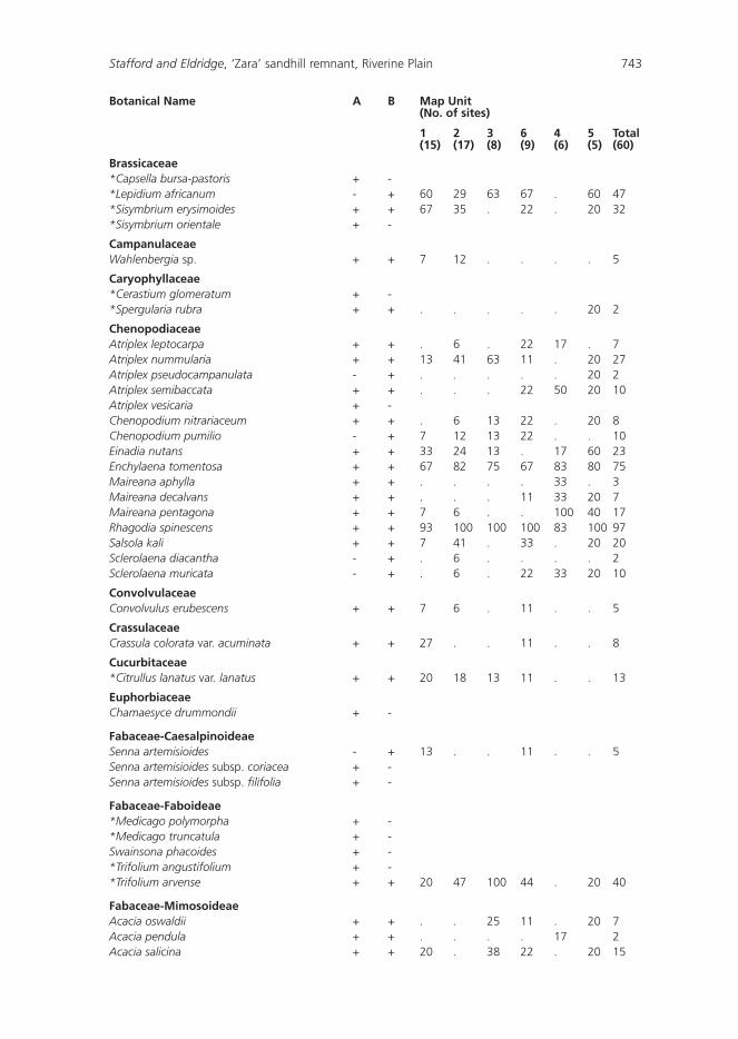
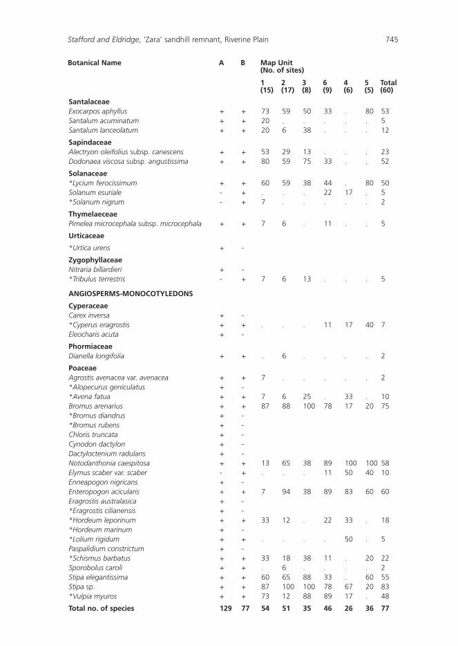
724 Cunninghamia Vol. 6(3): 2000

Families known to contain a conspicuous number of exotics such as Poaceae, Brassicaceae and Boraginaceae occurred at more than half of the sites sampled (Table 2). Only 12 species occurred in more than half of the sites (Table 3), and of these three were exotic, and included the declared noxious weed Lycium ferocissimum. Examination of Table 3 and Appendix 1 indicates that Rhagodia spinescens and Enchylaena tomentosa occurred in more than 45 sites and in all Map Units. These shrubs, from the family Chenopodiaceae, could be regarded as characteristic of the ‘Zara’ exclosure. A high proportion (48%) of species occurred in less than 10% of the sites.
Table 2. The most common families surveyed within the exclosure.
1frequency is out of a total of 77 (the total number of species found in the present study), 2frequency is out of a total of 144 (the total number of species found in the present study and Mulham’s unpublished study).
Family No. of sites Frequency1 of species found Frequency2 of species occupied during the current survey found for ‘Zara’, overall (% out of 77) (% out of 144).
Chenopodiaceae 60 15 (19%) 16 (11%)
Poaceae 60 13 (17%) 24 (17%)
Aizoaceae 38 1 (1%) 1 (1%)
Brassicaceae 38 2 (3%) 4 (3%)
Santalaceae 38 3 (4%) 3 (2%)
Boraginaceae 36 3 (4%) 3 (2%)
Sapindaceae 34 2 (3%) 2 (1%)
Fabaceae 33 5 (7%) 10 (7%)
Solanaceae 32 3 (4%) 3 (2%)
Asteraceae 11 5 (7%) 22 (15%)
Table 3. The most common species found during the survey.
Frequency refers to the number of sites, out of 60, where the particular species was found. *indicates an exotic species.
Species Name Frequency Family
Rhagodia spinescens 58 Chenopodiaceae
Stipa spp. 50 Poaceae
Enchylaena tomentosa 45 Chenopodiaceae
Bromus arenarius 45 Poaceae
*Mesembryanthemum crystallinum 38 Aizoaceae
Enteropogon acicularis 36 Poaceae
Notodanthonia caespitosa 35 Poaceae
Stipa elegantissima 33 Poaceae
*Echium plantagineum 33 Boraginaceae
Exocarpos aphyllus 32 Santalaceae
Dodonaea viscosa subsp. angustissima 31 Sapindaceae
*Lycium ferocissimum 30 Solanaceae
Stafford and Eldridge, ‘Zara’ sandhill remnant, Riverine Plain 725
Vegetation groupings based on site classification
The dendrogram (Fig. 2) indicated that six groups (Map Units) provided the most appropriate level of detail for mapping the vegetation in the exclosure. These six Map Units corresponded to three intergrading vegetation communities found on the Riverine Plain (Cunningham et al. 1981, Semple 1990, Porteners 1993), and closely reflect the vegetation patterns observed on the aerial photograph (Fig. 3).
Species found within each of the six Map Units, and the percentage of sites occupied by each species within a Map Unit are shown in Appendix 1. While Map Units 1 to 5 lay within generally well-defined communities, boundaries between these units are gradational. Map Unit 6 represents a transition from one community to another. As Map Units 1, 2, 3 and 6 have similar complements of species compared to Map Units 4 and 5, these units are discussed together. In discussion of Map Units 1, 2, 3 and 5, superscripts indicate the Map Units in which the species occur, and no superscript indicates occurrence in all four Map Units.
Map Units 1, 2, 3 and 6: Callitris Mixed Woodland
Map Units 1, 2, 3 and 6 correspond to the Callitris Mixed Woodland described by Porteners (1993). See Figs 3 and 4. Callitris glaucophylla was abundant in Map Unit 1 but scattered in Map Units 2 and 3. Alectryon oleifolius subsp. canescens, which was scattered within Map Units 1 and 2, appears to replace Callitris glaucophylla as the latter diminishes. The understorey consisted of Rhagodia spinescens, Dodonaea viscosa subsp. angustissima, Hakea tephrosperma12, Eremophila longifolia, Atriplex nummularia23 and Enchylaena tomentosa. Lycium ferocissimum and Exocarpos aphyllus were also found in Map Units 1, 2, 3 and 6.
Ground flora comprised short-lived annual and perennial grasses and herbs, many of them exotics (Porteners 1993). These included Mesembryanthemum crystallinum123, Bromus arenarius, Stipa spp., Echium plantagineum, Stipa elegantissima, Notodanthonia caespitosa236 and Sisymbrium erysimoides12. Species found at a low number of sites included Sisymbrium orientale, Schismus barbatus, Einadia nutans, Hordeum leporinum and Jasminum lineare. Vulpia myuros was abundant in Map Units 1, 3 and 6, while Atriplex nummularia and Trifolium arvense characterized both Map Units 2 and 3. Map Unit 6 was characterized by the absence of Mesembryanthemum crystallinum and a very low cover-abundance of Dodonaea viscosa subsp. angustissima.
Map Units 1 and 2 accounted for the greatest coverage of the exclosure (Fig. 3), and supported the greatest number of either native or exotic species. The number of exotics and the total number of species, for each Map Unit, were significantly positively correlated (r = 0.91, P < 0.02). Of the four Map Units included in the Callitris Mixed Woodland, only Map Units 1 and 2 had unique species. Of the 71 species within the Callitris Mixed Woodland, 29 were absent from both Map Units 4 and 5.
Map Unit 4: White-top Grassland
Map Unit 4 corresponded to Porteners (1993) White-top Grassland with the perennial grass Notodanthonia caespitosa abundant at all sites (Fig. 5). Associated grasses of high abundance included the perennials Stipa spp., Enteropogon acicularis, Elymus scaber var.
726 Cunninghamia Vol. 6(3): 2000

Fig. 2. Dendrogram showing the classification of the 60 sites into the six Map Units based on species abundance and cover.
Stafford and Eldridge, ‘Zara’ sandhill remnant, Riverine Plain 727

Fig. 3. Distribution of the six Map Units and three vegetation communities defined by cluster analysis.
728 Cunninghamia Vol. 6(3): 2000

Stafford and Eldridge, ‘Zara’ sandhill remnant, Riverine Plain 729
scaber and the exotic annual Hordeum leporinum. Associated forbs included the annual weed Echium plantagineum, and the perennial Maireana pentagona. Perennial shrubs Rhagodia spinescens, Atriplex semibaccata and Enchylaena tomentosa were also associated with Notodanthonia caespitosa in Map Unit 4.
Apart from the absence of trees and taller shrubs, Map Unit 4 is distinguished from the other units by the absence of Bromus arenarius, Stipa elegantissima, Sisymbrium orientale and Lycium ferocissimum. This unit also has the lowest mean number of species per site, the lowest total number of species, and the lowest number of exotics.
Statistically, the lower species diversity of the White-top Grassland (Map Unit 4) was significantly different to the higher diversity of the Callitris Mixed Woodland (Map Units 1, 2, 3 and 6; F5,54 = 5.01, P < 0.05). Species richness was also greater for Map Units 1, 2 and 3 of the Callitris Mixed Woodland which was significantly different to the lower species richness of the White-top Grassland (Map Unit 4; F5,54 = 7.68, P < 0.05). Although these results give an indication of species richness and diversity across the site, the data are probably influenced by season.
Map Unit 5: Black Box Woodland
Map Unit 5 was characterised by a high cover-abundance of Eucalyptus largiflorens (Fig. 6). This unit accounted for the smallest coverage of the exclosure (Fig. 3) and included 29 native and 7 exotic species. The number of species per site ranged from 12 to 17. Eucalyptus largiflorens was associated with, in order of abundance, the perennial shrubs Rhagodia spinescens, Enchylaena tomentosa, Exocarpos aphyllus, Einadia nutans and
Fig. 4. Callitris Mixed Woodland with a Rhagodia spinescens and Atriplex nummularia understorey.

730 Cunninghamia Vol. 6(3): 2000
the noxious weed, Lycium ferocissimum. Associated ground flora included the perennial grasses Notodanthonia caespitosa, Enteropogon acicularis, Stipa elegantissima and the biennial exotic forb Sisymbrium orientale.
Apart from the absence of Mesembryanthemum crystallinum and Dodonaea viscosa subsp. angustissima, Map Unit 5 is distinguished from the other units by the notable absence of Stipa spp., Bromus arenarius and Echium plantagineum. Species endemic to Map Unit 5 were Eriochlamys behrii, Spergularia rubra and Atriplex pseudocampanulata.
Species-environment relations
Axes I and II of the CCA biplot (Fig. 7) accounted for 35.2% and 20.3% respectively of the variation in species distribution. The length of the vectors shown in Fig. 7 indicates the relative importance of the environmental variables in determining the two axes. Significant and important determinants of axis I were soil texture (proportion of sand in the soil), organic carbon, surface firmness, degree of cracking, crust coherence, cryptogam cover and electrical conductivity. Axis I consequently corresponded to a gradient of increasing clay content from left to right in Fig. 7. Plant cover, microtopography and litter cover were important determinants of axis II, with soil cover increasing from the top of Fig. 7 to the bottom. The angle between a vector and an axis provides an inverse measure of the relationship between the various environmental variables. As such, litter cover and plant cover are shown to be inversely related.
Fig. 5. White-top Grassland characterised by Notodanthonia caespitosa associated with Stipa spp., Enteropogon acicularis and some Rhagodia spinescens shrubs

The majority of the 30 species, including those omitted from the plot for cartographic reasons, were clustered close to the centroid (origin). These were generally species common at most sites (e.g. Rhagodia spinescens (Rgsp) and Enchylaena tomentosa (Ehlt)) or species which showed little affinity with any of the measured environmental variables. Some species however showed strong preferences for certain environmental variables. In the upper left-hand sector of the CCA biplot (Fig. 7) are those species which are correlated with sandy (coarse-textured) soils with moderate levels of litter cover. These include Callitris glaucophylla (Klta), Alectryon oleifolius subsp. canescens (Aleo) and Dodonaea viscosa subsp. angustissima (Ddat). Hakea tephrosperma (Hkts) showed an affinity with increasing levels of litter cover and reduced plant cover, whilst Mesembryanthemum crystallinum (Msbc) was associated with soils of reduced clay content, low electrical conductivity and sparse cryptogam cover. The above are the key species that define the Callitris Mixed Woodland. Their distribution on the biplot indicates their relative contributions in defining the community.
Two species, Hordeum leporinum (Hodl) and Maireana pentagona (Mapg; lower right sector) were associated with sites of high clay content and abundant plant cover. Notodanthonia caespitosa (Dacp), Enteropogon acicularis (Enta) and Echium plantagineum (Ekmp) are also associated with predominantly clay textured soil, although to a lesser extent. Those that were also correlated with rough soils (high microtopography), high foliage cover of plants, low levels of organic carbon and a lower clay content (lower left-hand sector), included Citrullus lanatus (Ctrl) and Atriplex nummularia (Atnm).
Stafford and Eldridge, ‘Zara’ sandhill remnant, Riverine Plain 731
Fig. 6. Black Box Woodland dominated by Eucalyptus largiflorens with an understorey of Rhagodia spinescens.

Eucalyptus largiflorens (Uklf) occurred in the right hand sector of Fig. 7 and is strongly associated with sites of abundant litter cover, loamy soils (high organic carbon levels) and with a sparse foliage cover. Einadia nutans (Einn) and Acacia salicina (Aksa) also showed a similar association.
Soil surface condition
The soil surface in the exclosure was generally intact, moderately stable and uneroded, with low to moderate microtopography on low (< 3%) slopes (Table 4). Approximately half of the surfaces were non-coherent, and the majority of soils had sandy or sandy loam surface textures. Litter cover in the quadrats was moderate, locally derived i.e. not transported from elsewhere, and poorly broken down and incorporated into the soil surface. Predictably, given soil surface textures, cryptogam cover was sparse. While foliage cover of vascular plants was highly variable across the exclosure, basal cover was generally low. The dominant erosion form at the site was sheet erosion of sandy material.
Table 4. Distribution of the soil surface variables across the 60 sites.
Classes are shown in the first row, and the percentage of each class is given in the second row.
A. Slope (%) 0 1–3 3–5 5–10 > 10 11 86 2 1 0
B. Microtopography < 3 3–8 8–25 25–100 >100 (mm) 7 40 42 11 0
C. Crust coherence Sand Easily Moderately Very Non- broken hard hard brittle or self- mulching 11 43 14 22 10
D. Cracking Extensively Moderately Slightly Intact broken broken broken 0 2 8 90
E. Firmness Very loose Loose Moderately Firm firm 0 0 67 33
F. Cryptogams (%) <1 1–10 10–50 > 50 65 19 13 3
G. Sheet erosion Extensive Moderate Slight Insignificant 0 3 23 74
H. Soil cover (%) < 1 1–15 15–30 30–50 > 50 11 31 30 21 7
I. Basal cover (mm) < 7 7–70 70–140 > 140 62 29 8 1
J. Litter cover (%) < 10 10–25 25–50 50–75 75–100 100 (several cm thick) 14 26 38 15 5 2
K. Litter source Local Transported 100 0
L. Litter incorporation Low Moderate Extensive 71 12 17M. Texture Light Clay Clay loam Loam Sandy Sand loam 2 8 18 43 29
732 Cunninghamia Vol. 6(3): 2000
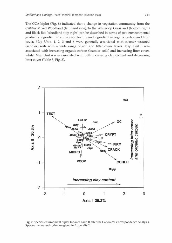
The CCA biplot (Fig. 8) indicated that a change in vegetation community from the Callitris Mixed Woodland (left hand side), to the White-top Grassland (bottom right) and Black Box Woodland (top right) can be described in terms of two environmental gradients: a gradient in surface soil texture and a gradient in organic carbon and litter cover. Map Units 1, 2, 3 and 6 were generally associated with coarser textured (sandier) soils with a wide range of soil and litter cover levels. Map Unit 5 was associated with increasing organic carbon (loamier soils) and increasing litter cover, whilst Map Unit 4 was associated with both increasing clay content and decreasing litter cover (Table 5, Fig. 8).
Stafford and Eldridge, ‘Zara’ sandhill remnant, Riverine Plain 733
Fig. 7. Species-environment biplot for axes I and II after the Canonical Correspondence Analysis. Species names and codes are given in Appendix 2.

Soil chemical characteristics
Overall, the soils within the exclosure were non-saline (EC1:5 < 0.40 dS/m) and slightly acidic, with low percentages of organic carbon (Table 6). Electrical conductivity (EC) on Map Units 1, 2 and 3 were significantly lower than for Units 4 and 6 (P < 0.05), whilst Map Unit 5 was not significantly different to the other units.
Discussion
Floristics
Eighty-two percent (49) of the 60 sites in the ‘Zara’ exclosure corresponded to Porteners’ (1993) Callitris Mixed Woodland, and the remainder corresponded with the Black Box Woodland and the White-top Grassland units. The Callitris Mixed Woodland had significantly greater species richness and diversity (Shannon-Weiner index) compared with the White-top Grassland and Black Box Woodland.
Consistent with other studies of the Riverine Plain and surrounding areas (Semple 1986, 1987, Porteners 1993, Sivertson & Metcalfe 1995), the Poaceae, Asteraceae, Chenopodiaceae and Fabaceae families were most represented (Table 2). Of the 977 species recorded for the Riverine Plain as a whole (Porteners 1993), 144 have been recorded at ‘Zara’ (Appendix 1)
The small number of species in common with other studies can be explained by two main factors. Firstly, the present study was conducted at only one point in time, during a very dry summer. Consequently, only summer-growing and/or drought tolerant plants were recorded. Further collections made during winter/spring or after rain are likely to increase the number of species recorded, particularly annuals and ephemerals. Secondly, as the exclosure is less than 60 hectares in area, it represents only a small proportion of the landscapes found over the Riverine Plain.
Relationships between soils and vegetation
In our study, the distribution of communities was closely associated with a range of environmental variables including soil texture, cracking, coherence, stability, organic carbon, plant cover and litter cover (Fig. 7). In general, the Callitris Mixed Woodland was associated with sandy, coarse-textured soils, the Black Box Woodland with loamier soils, and the White-top Grassland with finer clay-textured soils (Fig. 8). Soil texture, by influencing soil moisture availability, is known to be a critical determinant of species distribution (Noy-Meir 1974, Eldridge 1988).
Within the White-top Grassland, moisture availability is strongly influenced by the high clay content of soils (Williams 1956). Despite surface ponding, the high shrink swell capacity of clays limits the depth of water infiltration to approximately 30 cm (Eldridge 1988). Available water for plants is then limited by the high water holding capacity of the soils. Consequently, the vegetation within Map Unit 4 is dominated by short-lived ephemerals, perennial grasses and perennial shrubs such as Maireana pentagona which have shallow, lateral roots confined to the top 30 cm of the soil. The
734 Cunninghamia Vol. 6(3): 2000

limited water availability for plants, the difficulty for roots to penetrate the hardsetting soils (Williams 1956), the extensive cracking of the soil and the generally high salinity levels means that trees are generally restricted to either sandy rises, prior stream levees, or active watercourses (Semple 1990).
The combination of loamy soils with heavy clay subsoils, abundant litter and the probability of low water availability (due to the dense cover of Eucalyptus largiflorens), is probably responsible for the sparse plant cover in the Black Box Woodland sites (Table 5). Despite this sparse plant cover, compared with that in the Callitris Mixed Woodland (Fig. 8), the dense litter cover on these soils, a contribution from the upper canopy, is sufficient to protect the surface against raindrop impact, preventing soil slaking and surface sealing, and reducing overland flow of water and sediment movement. Litter also improves the condition of the soil by providing a source of organic matter, encouraging soil biota, leading to greater levels of porosity and therefore infiltration (Eldridge & Koen 1993).
In contrast to the clay soils, the earthy sands of the Callitris Mixed Woodland are highly permeable (Eldridge 1989), and characterised by low levels of organic carbon, and consequently low levels of electrical conductivity (Table 6). The deeper, sandier soils of the dune crest supported Callitris glaucophylla and shrubs such as Dodonaea viscosa which occur on sandplains and dune fields in the north-west of NSW at relatively high densities (Hodgkinson 1992). In sandy soils, a combination of relatively deeper penetration of water, and the availability of much of this moisture for germination, means that, compared with clay soils, sands respond much more rapidly to small falls of rain (Johns et al. 1984). As rainfall in the area is generally winter-dominant, much of the ephemeral growth at the time of the study is likely to be restricted to the sandy soils. This probably accounts for the relatively larger number of ephemeral species found on the sandy soils and perhaps the large numbers of weedy species compared with the clay soils.
Management of the ‘Zara’ exclosure
The Riverine Plain has been grazed by domestic livestock for more than 150 years, and is a severely modified landscape (Benson 1988). Fragmentation has left the exclosure isolated from other sandhills, and with a large perimeter across which exotic plants can penetrate. Monitoring of vegetation cover, invasion of exotics (both plants and animals) as well as soil health is an essential component of the management of ‘Zara’. Strategies such as minimising disturbances in and around the exclosure to prevent the spread of exotics, and fencing of a buffer strip around the exclosure are likely to enhance the conservation value of the exclosure.
The present survey indicated that the vegetation communities at ‘Zara’ have already been substantially modified by the invasion of exotic weeds such as Lycium ferocissimum, and currently support relatively high abundances of common Mediterranean weeds such as Citrullus lanatus var. lanatus, Mesembryanthemum crystallinum and Echium plantagineum. Dispersal of these exotics is enhanced by disturbance by livestock and rabbits. Exotic plants influence the vegetation communities directly by their presence, and indirectly through competition with
Stafford and Eldridge, ‘Zara’ sandhill remnant, Riverine Plain 735

Tab
le 5
. So
il su
rfac
e va
riab
les
and
th
eir
dis
trib
uti
on
acr
oss
th
e si
x M
ap U
nit
s.
Varia
bles
whi
ch c
hang
ed li
ttle
acr
oss
the
site
s ha
ve b
een
excl
uded
. Th
e m
odal
(m
ost
com
mon
) va
lue
is in
the
firs
t ro
w,
and
the
rang
e of
val
ues,
rec
orde
d fo
r ea
ch M
ap U
nit,
in
the
sec
ond;
100
+ f
or li
tter
cov
er in
dica
tes
100%
cov
er b
ut s
ever
al c
m t
hick
; m
od.
= m
oder
atel
y.
Map
Un
it
Text
ure
C
rust
Fi
rmn
ess
Mic
roto
po
gra
ph
y C
ryp
tog
am
Soil
Bas
al
Litt
er
coh
eren
ce
(m
m)
cove
r (%
) co
ver
(%)
cove
r (%
) co
ver
(%)
1 sa
nd
ea
sily
bro
ken
m
od
. firm
3
to 8
<
1
1 to
15
< 7
50
to
75
(s
and
to lo
am)
(san
d to
ver
y ha
rd)
(mod
. fir
m t
o fir
m)
(< 3
to
100)
(<
1 t
o 50
) (<
1 t
o >
50)
(<
7 t
o 14
0)
(< 1
0 to
100
)
2 sa
nd
y lo
am
easi
ly b
roke
n
mo
d. fi
rm
8 to
25
< 1
1
to 1
5 <
7
25 t
o 5
0
(s
and
to s
andy
loam
) (s
and
to v
ery
hard
) (m
od.
firm
to
firm
) (<
3 t
o 10
0)
(< 1
to
> 5
0)
(< 1
to
> 5
0)
(< 7
to
> 1
40)
(< 1
0 to
75)
3 sa
nd
y lo
am
easi
ly b
roke
n
mo
d. fi
rm
3 to
8
< 1
15
to
30
7 to
70
10 t
o 2
5
(s
and
to s
andy
loam
) (s
and
to s
elf
mul
chin
g)
(mod
. fir
m t
o fir
m)
(< 3
to
25)
(< 1
to
10)
(1 t
o >
50)
(<
7 t
o 14
0)
(10
to 7
5)
6 lo
am
easi
ly b
roke
n
firm
3
to 8
<
1
15 t
o 3
0 7
to 7
0 25
to
50
(s
andy
loam
to
(e
asily
bro
ken
to
(mod
. fir
m t
o fir
m)
(< 3
to
100)
(<
1 t
o >
50)
(<
1 t
o >
50)
(<
7 t
o 14
0)
(< 1
0 to
100
)
clay
loam
)
self
mul
chin
g)
4 cl
ay lo
am
self
-mu
lch
ing
fi
rm
8 to
25
1 to
10
30 t
o 5
0 <
7
25 t
o 5
0
(lo
am t
o cl
ay)
(ver
y ha
rd t
o (fi
rm)
(3 t
o 10
0)
(< 1
to
50)
(1 t
o 50
) (<
7 t
o 70
) (1
0 to
50)
se
lf m
ulch
ing)
5 lo
am
easi
ly b
roke
n
firm
8
to 2
5 10
to
50
1 to
15
< 7
25
to
50
(s
andy
loam
(e
asily
bro
ken
to
(mod
. fir
m t
o fir
m)
(< 3
to
25)
(< 1
to
> 5
0)
(< 1
to
50)
(< 7
to
70)
(< 1
0 to
100
+)
to
loam
) se
lf m
ulch
ing)
Tab
le 6
. D
iffe
ren
ces
in e
lect
rica
l co
nd
uct
ivit
y (E
C),
org
anic
car
bo
n (
OC
) an
d p
H b
etw
een
th
e si
x M
ap U
nit
s
Map
Un
its
(nu
mb
er o
f si
tes)
1
2 3
6 4
5 To
tal
Var
iab
les
(30)
(3
4)
(16)
(1
8)
(12)
(1
0)
(120
)
EC (
dS m
-1)
0.08
(0.
02)a
b 0.
06 (
0.01
)ab
0.06
(0.
01)a
b 0.
15 (
0.04
)bc
0.12
(0.
01)b
c 0.
09 (
0.02
)abc
0.
09 (
0.01
)
OC
(%)
1.04
(0.
11)a
1.
01 (
0.07
)a
0.76
(0.
04)a
1.
31 (
0.17
)a
1.98
(0.
11)b
3.
16 (
0.70
)c
1.31
(0.
09)
pH
6.45
(0.
09)a
6.
36 (
0.04
)a
6.43
(0.
09)a
6.
27 (
0.10
)a
6.21
(0.
09)a
6.
42 (
0.04
)a
6.37
(0.
03)
Stan
dard
err
or o
f th
e m
ean
is in
par
enth
eses
. Va
lues
with
in a
row
with
a s
imila
r su
pers
crip
t ar
e no
t si
gnifi
cant
ly d
iffer
ent
at P
= 0
.05.
Ele
ctric
al c
ondu
ctiv
ity d
ata
wer
e lo
g 10
tran
sfor
med
prio
r to
AN
OVA
.
736 Cunninghamia Vol. 6(3): 2000
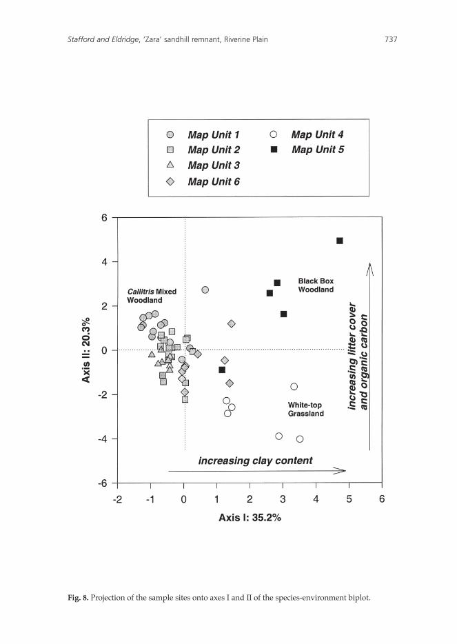
Fig. 8. Projection of the sample sites onto axes I and II of the species-environment biplot.
Stafford and Eldridge, ‘Zara’ sandhill remnant, Riverine Plain 737
738 Cunninghamia Vol. 6(3): 2000
native species (McIntyre 1990). Lycium ferocissimum for example, poses a major threat to the exclosure through its capacity to rapidly invade, colonise and reproduce. Lycium ferocissimum provides a harbour for rabbits, and, as the seeds are readily eaten and dispersed by birds, it is present in most areas of the exclosure and dispersal is not restricted by fencing (Appendix 1). Physical removal, combined with the judicious use of herbicides and fire, appears to be an ecologically desirable control option.
Of greater concern in the long-term is the spread of exotic forbs and grasses which are more difficult to control. It is probable that forbs such as Marrubium vulgare, Heliotropum spp. and Tribulus terrestris, as well as the annual grasses Avena spp., Lolium spp. and Bromus spp. will prove a greater challenge for managers. Large areas of the Riverine Plain have already been invaded by exotic forbs and grasses, and their control in the exclosure is likely to be ongoing.
Since the construction of the exclosure in 1997, the Southern Riverina Naturalists have undertaken a rabbit control program using 1080 poison baits in conjunction with the ripping of warrens. As the regeneration of Alectryon oleifolius subsp. canescens is limited, and the regeneration of Callitris glaucophylla is rarely seen in the presence of rabbits or livestock, ongoing rabbit control is essential. Monitoring of rabbit warrens and regular examination of the fencing is recommended.
Control of wildfire has been identified as a contentious issue in the management of the ‘Zara’ exclosure. It is apparent from the present survey and anecdotal evidence, that the cover and density of shrubs such as Rhagodia spinescens, Atriplex nummularia and Enchylaena tomentosa have increased markedly over the past few decades and will continue to increase given the removal of stock. This may be associated with reductions in ground cover of perennial grasses and a reduced risk of wildfire. In the absence of controlled burning, large areas of the exclosure, particularly in the Callitris Mixed Woodland are likely to be converted from a grassland to a chenopod- dominated shrubland. One of the benefits of shrub increase is that the exclosure now provides a regular local seed source of native shrubs. These are collected and used extensively by Greening Australia in revegetation programs.
Conservation significance of the ‘Zara’ exclosure
The ‘Zara’ exclosure is an important example of the Callitris Mixed Woodlands which were once more common on aeolian landscapes on the Riverine Plain. Today this vegetation community is poorly conserved, threatened or vulnerable, due to inappropriate land use practices (Benson 1988, 1989, 1991, Eardley 1999). The Callitris Mixed Woodland at ‘Zara’ has a healthy understorey, and unlike many sandhills in the area, the community has retained part of its original shrub component (including Atriplex nummularia in Map Units 2 and 3).
Although not found in the present study, one ROTAP species Ptilotus extenuatus (Appendix 1, Briggs & Leigh 1996) was collected from the exclosure. Ptilotus extenuatus is now the only plant species presumed to be extinct on the Hay Plain, and despite numerous attempt to locate other specimens (Briggs & Leigh 1996) the species has not been recorded. Calotis moorei, a Schedule 1 species under the

Threatened Species Conservation Act was also collected at ‘Zara’ in the early 1900s (Short 1991). Additional species may be collected in the future following the exclusion of domestic and feral grazing animals.
The future of the ‘Zara’ exclosure
The present study provides a basis for future management strategies for sandhill remnants and monitoring programs. Being close to a large population centre (Deniliquin), the exclosure could serve as a focal point for community groups interested in learning more about semi-arid vegetation communities. Permanent sample points, already in place, can provide an invaluable baseline for future soil and ecological studies, and regular updating of the species lists by members of the Riverina Field Naturalists. The reserve can also provide ungrazed, benchmark sites to be incorporated into the Department of Land and Water Conservation’s Rangeland Assessment Program. Future studies in the exclosure could include an examination of small mammal populations in relation to vegetation communities, temporal changes in plant communities after exclosure and recruitment of Callitris glaucophylla and Alectryon oleifolius after removal of sheep, rabbits and noxious shrubs.
The exclosure has the potential to complement other remnants and more formal conservation practices within the Riverina Bioregion (Eardley 1999). However, for it to be successful in the long term, it is important that it be incorporated into any future Land and Water Management Plans and Regional Conservation Plans for the area.
Acknowledgments
We thank John Naimo of Greening Australia for his assistance throughout the duration of the study, and members of Green Corp who collected soil samples and pegged out the site. Bill Mulham assisted with plant identification and provided valuable comments on an earlier draft. We are grateful to Bob and Julie Pocklington for providing accommodation at the ‘Zara’ homestead, to Terry Koen for his contribution to the cluster analysis, and to Chris Myers and Dorothy Yu for assistance and advice with laboratory work.
ReferencesBelbin, L. (1990) PATN Pattern Analysis Package (CSIRO: Canberra).Benson, J.S. (1988) Conservation of flora in western New South Wales. National Parks Journal
32: 16–22.Benson, J.S. (1989) Establishing priorities for the conservation of rare and threatened plants and
plant associations in New South Wales. In: M. Hicks and P. Eiser (eds) The conservation of threatened species and their habitats (Australian Committee for IUCN: Canberra).
Benson, J.S. (1991) The effect of 200 years of European settlement in the vegetation and flora of New South Wales. Cunninghamia 2: 343–370.
Benson, J.S., Ashby, E.M. & Porteners, M.F. (1997) The native grasslands of the Riverine Plain, New South Wales. Cunninghamia 5: 1–48.
Brickhill, J. (1985) Review of Nature Conservation Programmes, Paper No. 13, Vegetation by geographic regions. Southern Riverina (New South Wales National Parks and Wildlife Service: Griffith District).
Stafford and Eldridge, ‘Zara’ sandhill remnant, Riverine Plain 739

Briggs, J.D. & Leigh, J.H. (1996) Rare or Threatened Australian Plants (Centre for Plant Biodiversity Research: CSIRO).
Bureau of Meteorology (1998) Climatic data for selected areas of the Riverine Plain (Climate and Consultancy Section; Bureau of Meteorology; NSW).
Butler, B.E., Blackburn, G., Bowler, J.M., Lawrence, C.R., Newell, J.W. & Pels, S. (1973) A geomorphic map of the Riverine Plain of south-eastern Australia (Australian National University Press: Canberra).
Colwell, J.D. (1969) Auto-analyser procedure for organic carbon analysis of soil. CSIRO Aust. Division of Soils National Fertility Project Circular No. 5.
Cunningham, G.M., Mulham, W.E., Milthorpe, P.L. & Leigh, J.H. (1981) Plants of Western New South Wales (Soil Conservation Service of NSW: Sydney).
Eardley, K.A. (1999) A Foundation for Conservation in the Riverina Bioregion. Unpublished report (NSW National Parks and Wildlife Service: Hurstville).
Edwards, K. (1979) Rainfall in New South Wales with special reference to soil conservation. Soil Conservation Technical Handbook No. 3 (Soil Conservation Service of NSW: Sydney).
Eldridge, D.J. (1988) Soil-landform and vegetation relations in the chenopod shrublands of western New South Wales. Earth-Science Reviews 25: 493–499.
Eldridge, D.J. (1990) Soils In: Hay District Technical Manual (Soil Conservation Service: Condobolin).
Eldridge, D.J. & Greene, R.S.B. (1996) Microbiotic soil crusts: a review of their roles in soil and ecological processes in the rangelands of Australia. Australian Journal of Soil Research 32: 389-415.
Eldridge, D.J. & Koen, T.B. (1993) Run-off and sediment yield from a semi-arid woodland in Eastern Australia. II. Variation in some soil hydrological properties along a gradient in soil surface condition. Rangeland Journal 15: 234–46.
Groves, R.H. (1986) Plant invasions of Australia: an overview. In R.H. Groves and J.J. Burdon (eds) Ecology of biological invasions: An Australian perspective (Australian Academy of Science: Canberra).
Harden, G.J.(ed.) (1990–93) Flora of New South Wales: Volumes 1–4 (University of New South Wales Press: Kensington).
Hodgkinson, K.C. (1992) Water relations and growth of shrubs before and after fire in a semi-arid woodland. Oecologia 90: 467–73.
Johns, G.G., Tongway, D.J. & Pickup, G. (1984) Land and water processes. In: G.N. Harrington, A.D. Wilson and M.D. Young (eds) Management of Australia’s Rangelands. pp. 25–40 (CSIRO: Canberra).
Leigh, J.H. & Mulham, W.E. (1977) Vascular plants of the Riverine Plain of New South Wales with notes on distribution and pastoral use. Telopea 1: 225–293.
Minitab (1989) MINITAB Reference Manual, Release 7 (Minitab Incorporated: Pennsylvania).Moore, C.W.E. (1953) The Vegetation of the South-eastern Riverina, New South Wales. I. The
climax communities. Australian Journal of Botany 1: 485–547Mueller-Dombois, D. & Ellenberg, H. (1974) Aims and Methods of Vegetation Ecology (John Wiley
and Sons: USA).Northcote, K. H. 1979. A Factual Key to the Recognition of Australian Soils (Glen Osmond: S.A).Noy-Meir, I. (1974) Multivariate analysis of the semi-arid vegetation in South-eastern Australia.
II Vegetation catenae and environmental gradients. Australian Journal of Botany 22: 115–40.O’Halloran, A.F. (1995) A review of information relevant to the southern grassland rangelands of
western New South Wales. Technical Report No. 28 (Soil Conservation Service of NSW: Condobolin).
Porteners, M. F. (1993) The natural vegetation of the Hay plain: Booligal-Hay and Deniliquin-Bendigo 1: 250 000 maps. Cunninghamia 3: 1–122.
Rhodes, D. W. (1990) Climate In: Hay District Technical Manual (Soil Conservation Service of NSW: Condobolin).
Semple, W.S. (1986). Plant species lists from four exclosure sites in the Hay District of south-western New South Wales. Cunninghamia 1: 491–502.
Semple, W.S. (1987) Prior streams and Queel Queel gums — regeneration areas revisited. Journal of Soil Conservation 43: 38–43.
Semple, W.S. (1990) Introduction, Landforms In: Hay District Technical Manual (Soil Conservation Service of NSW: Condobolin).
740 Cunninghamia Vol. 6(3): 2000

Stafford and Eldridge, ‘Zara’ sandhill remnant, Riverine Plain 741
Short, P.S. (1991) A new species of Calotis R. Br. (Asteraceae: Astereae) from New South Wales. Muelleria 7: 405–410.
Sivertsen, D. & Metcalfe, L. (1995) Natural vegetation of the southern wheat-belt (Forbes and Cargelligo 1: 250 000 map sheets). Cunninghamia 4: 103–128.
ter Braak, C. J. F. (1986) Canonical correspondence analysis: A new eigen vector technique for multivariate direct gradient analysis. Ecology 67: 1167–1179.
ter Braak, C.J.F. (1991) CANOCO — A FORTRAN program for Canonical Community Ordination. (Microcomputer Power, Ithaca, New York, USA).
Tongway, D.J. (1995) Monitoring soil productive potential. Environmental Monitoring and Assessment 37: 303–318.
Williams, O. B. (1956) Studies in the ecology of the Riverine Plain II. Plant-soil relationships in three semi-arid grasslands. Australian Journal of Agricultural Research 7: 127–139.
Manuscript accepted 2 May 2000

Appendix 1: Species recorded for the ‘Zara’ enclosure, and the percentage of sites containing a particular speices within each of the six Map Units.
A = Mulham (unpub.); B = present study; + = species found; - = species not found; * = exotics; ! = ROTAP species; z = recorded by Short (1991).
Botanical Name A B Map Unit (No. of sites)
1 2 3 6 4 5 Total (15) (17) (8) (9) (6) (5) (60)
PTERIDOPHYTES
AdiantaceaeCheilanthes austrotenuifolia + + . 6 . . . . 2
MarsileaceaeMarsilea drummondii - + . . . 11 . 20 3
GYMNOPERMS
CupressaceaeCallitris glaucophylla + + 80 29 25 . . . 32
ANGIOSPERMS-DICOTYLEDONS
Aizoaceae*Mesembryanthemum crystallinum + + 93 100 88 . . . 63
AmaranthaceaeAlternanthera denticulata + -!Ptilotus extenuatus + -
ApiaceaeDaucus glochidiatus + -
AsteraceaeActinobole uliginosum + + 13 12 . . . . 7*Arctotheca calendula + -*Aster subulatus + -Brachycome lineariloba - + . 6 . . . . 2Calotis sp. - + 7 . . . . . 2Calotis erinacea + -ZCalotis moorei - -Calotis scabiosifolia + -Calotis scapigera + -*Carthamus lanatus + -*Centaurea melitensis + -Centipeda cunninghamii + -Chrysocephalum apiculatum + -*Chrysocephalum semipapposum + -*Cirsium vulgare + -*Cotula bipinnata + -Eriochlamys behrii - + . . . . . 20 2*Hypochaeris glabra + -Pseudognaphalium luteoalbum + -Senecio quadridentatus + + 13 . . . . 20 5*Sonchus oleraceus + -Stuartina muelleri + -Vittadinia cuneata group + + 7 6 . 11 . . 5*Xanthium spinosum + -
Boraginaceae*Amsinckia intermedia + + 13 . 13 . . . 5*Echium plantagineum + + 27 71 100 56 67 . 55*Heliotropium europaeum + + 7 12 . 11 . . 7
742 Cunninghamia Vol. 6(3): 2000
Brassicaceae*Capsella bursa-pastoris + -*Lepidium africanum - + 60 29 63 67 . 60 47*Sisymbrium erysimoides + + 67 35 . 22 . 20 32*Sisymbrium orientale + -
CampanulaceaeWahlenbergia sp. + + 7 12 . . . . 5
Caryophyllaceae*Cerastium glomeratum + -*Spergularia rubra + + . . . . . 20 2
ChenopodiaceaeAtriplex leptocarpa + + . 6 . 22 17 . 7Atriplex nummularia + + 13 41 63 11 . 20 27Atriplex pseudocampanulata - + . . . . . 20 2Atriplex semibaccata + + . . . 22 50 20 10Atriplex vesicaria + -Chenopodium nitrariaceum + + . 6 13 22 . 20 8Chenopodium pumilio - + 7 12 13 22 . . 10Einadia nutans + + 33 24 13 . 17 60 23Enchylaena tomentosa + + 67 82 75 67 83 80 75Maireana aphylla + + . . . . 33 . 3Maireana decalvans + + . . . 11 33 20 7Maireana pentagona + + 7 6 . . 100 40 17Rhagodia spinescens + + 93 100 100 100 83 100 97Salsola kali + + 7 41 . 33 . 20 20Sclerolaena diacantha - + . 6 . . . . 2Sclerolaena muricata - + . 6 . 22 33 20 10
ConvolvulaceaeConvolvulus erubescens + + 7 6 . 11 . . 5
CrassulaceaeCrassula colorata var. acuminata + + 27 . . 11 . . 8
Cucurbitaceae*Citrullus lanatus var. lanatus + + 20 18 13 11 . . 13
EuphorbiaceaeChamaesyce drummondii + -
Fabaceae-CaesalpinoideaeSenna artemisioides - + 13 . . 11 . . 5Senna artemisioides subsp. coriacea + -Senna artemisioides subsp. filifolia + -
Fabaceae-Faboideae*Medicago polymorpha + -*Medicago truncatula + -Swainsona phacoides + -*Trifolium angustifolium + -*Trifolium arvense + + 20 47 100 44 . 20 40
Fabaceae-Mimosoideae Acacia oswaldii + + . . 25 11 . 20 7Acacia pendula + + . . . . 17 2Acacia salicina + + 20 . 38 22 . 20 15
Stafford and Eldridge, ‘Zara’ sandhill remnant, Riverine Plain 743
Botanical Name A B Map Unit (No. of sites)
1 2 3 6 4 5 Total (15) (17) (8) (9) (6) (5) (60)

Geraniaceae*Erodium cicutarium + -Erodium crinitum + -
GoodeniaceaeGoodenia fascicularis + -Goodenia pinnatifida + -Goodenia pusilliflora + -
Lamiaceae*Marrubium vulgare + + 7 . . . . . 2Teucrium racemosum + + . . . 11 . 20 3
LoranthaceaeAmyema quandang + -Lysiana exocarpi subsp. exocarpi + -
Malvaceae *Malva parviflora + -Sida corrugata + + 7 . . 33 33 20 12
MyoporaceaeEremophila longifolia + + 27 47 88 44 17 20 42Myoporum montanum + -Myoporum platycarpum + + 7 6 . . . . 3
MyrtaceaeEucalyptus largiflorens + + 7 6 . 11 . 100 13Eucalyptus largiflorens x populnea + -
NyctaginaceaeBoerhavia coccinea + + 7 6 38 . 17 . 10
OleaceaeJasminum lineare + + 53 12 63 11 . 20 28
OxalidaceaeOxalis perennans + + . 6 . 11 17 20 7
PittosporaceaeBursaria spinosa subsp. microphylla + + 20 6 25 11 . . 12Pittosporum phylliraeoides + -
PlantaginaceaePlantago sp. + -
PolygonaceaeMuehlenbeckia florulenta + -*Polygonum aviculare + -
PortulacaceaeCalandrinia eremaea + -Portulaca oleracea + -
ProteaceaeHakea leucoptera + -Hakea tephrosperma + + 60 35 13 33 . . 32
RanunculaceaeClematis microphylla var. microphylla - + 20 . 50 . . . 12*Myosurus minimus + -Ranunculus pentandrus + -Ranunculus pumilio + -
RubiaceaeAsperula conferta + -
744 Cunninghamia Vol. 6(3): 2000
Botanical Name A B Map Unit (No. of sites)
1 2 3 6 4 5 Total (15) (17) (8) (9) (6) (5) (60)
SantalaceaeExocarpos aphyllus + + 73 59 50 33 . 80 53Santalum acuminatum + + 20 . . . . . 5Santalum lanceolatum + + 20 6 38 . . . 12
SapindaceaeAlectryon oleifolius subsp. canescens + + 53 29 13 . . . 23Dodonaea viscosa subsp. angustissima + + 80 59 75 33 . . 52
Solanaceae*Lycium ferocissimum + + 60 59 38 44 . 80 50Solanum esuriale - + . . . 22 17 . 5*Solanum nigrum - + 7 . . . . . 2
ThymelaeceaePimelea microcephala subsp. microcephala + + 7 6 . 11 . . 5
Urticaceae
*Urtica urens + -
ZygophyllaceaeNitraria billardieri + -*Tribulus terrestris - + 7 6 13 . . . 5
ANGIOSPERMS-MONOCOTYLEDONS
CyperaceaeCarex inversa + -*Cyperus eragrostis + + . . . 11 17 40 7Eleocharis acuta + -
PhormiaceaeDianella longifolia + + . 6 . . . . 2
PoaceaeAgrostis avenacea var. avenacea + + 7 . . . . . 2*Alopecurus geniculatus + -*Avena fatua + + 7 6 25 . 33 . 10Bromus arenarius + + 87 88 100 78 17 20 75*Bromus diandrus + -*Bromus rubens + -Chloris truncata + -Cynodon dactylon + -Dactyloctenium radulans + -Notodanthonia caespitosa + + 13 65 38 89 100 100 58Elymus scaber var. scaber - + . . . 11 50 40 10Enneapogon nigricans + -Enteropogon acicularis + + 7 94 38 89 83 60 60Eragrostis australasica + -*Eragrostis cilianensis + -*Hordeum leporinum + + 33 12 . 22 33 . 18*Hordeum marinum + -*Lolium rigidum + + . . . . 50 . 5Paspalidium constrictum + -*Schismus barbatus + + 33 18 38 11 . 20 22Sporobolus caroli + + . 6 . . . . 2Stipa elegantissima + + 60 65 88 33 . 60 55Stipa sp. + + 87 100 100 78 67 20 83*Vulpia myuros + + 73 12 88 89 17 . 48
Total no. of species 129 77 54 51 35 46 26 36 77
Stafford and Eldridge, ‘Zara’ sandhill remnant, Riverine Plain 745
Botanical Name A B Map Unit (No. of sites)
1 2 3 6 4 5 Total (15) (17) (8) (9) (6) (5) (60)

Appendix 2: Species names and codes (in alphabetical order) used in the cluster analysis and the Canonical Correspondence Analysis. * indicates an exotic species.
Code Species
Aksa Acacia salicina
Atnm Atriplex nummularia
Atsm Atriplex semibaccata
Avnf *Avena fatua
Bhvc Boerhavia coccinea
Bmar Bromus arenarius
Brss Bursaria spinosa subsp. microphylla
Cazz Calotis sp.
Chla Cheilanthes austrotenuifolia
Ctrl *Citrullus lanatus var. lanatus
Dacp Notodanthonia caespitosa
Ddat Dodonaea viscosa subsp. angustissima
Ehlt Enchylaena tomentosa
Ekmp *Echium plantagineum
Elms Elymus scaber var. scaber
Emlg Eremophila longifolia
Etpa Enteropogon acicularis
Exoa Exocarpos aphyllus
Hkts Hakea tephrosperma
Hodl *Hordeum leporinum
Jsml Jasminum lineare
Kltg Callitris glaucophylla
Kppm Chenopodium pumilio
Lcmf *Lycium ferocissimum
Leaf *Lepidium africanum
Mapg Maireana pentagona
Msbc *Mesembryanthemum crystallinum
Oleo Alectryon oleifolius
Rgsp Rhagodia spinescens
Sacg Sida corrugata
Sbme *Sisymbrium erysimoides
Semz Sclerolaena muricata
Shsb *Schismus barbatus
Sieg Stipa elegantissima
Sizz Stipa sp.
Slml Santalum lanceolatum
Slsk Salsola kali
Tmav *Trifolium arvense
Uklf Eucalyptus largiflorens
Vlpm *Vulpia myuros
746 Cunninghamia Vol. 6(3): 2000