v* *y a window open on the world courier -...
TRANSCRIPT

V*" "*y A window open on the world
CourierAugust-September 1973 (26th year) -U.K. : 26p - North America : II - France : 3.40 F

TREASURES
OF
WORLD ART
Tlaloc the rain-giver
(J)MEXICO
1 4 AOUT 1973
The most ancient among the fertility gods of the pre-Columbian peoples of Mexico was the rain-god Tlaloc. He was highly revered by the Totonacs, whose civilization is known to have flourish¬ed from the 7th to the 14th century on the coast of the Gulf of Mexico in what is now theMexican state of Veracruz. This recently-discovered Totonac earthenware statuette depictsa warrior bearing the attributes of Tlaloc. The circles round the eyes represent clouds (inthe Totonac language "tlaloc" means cloud) and the nose and mouth are in the form of theserpent-jaguar, symbolizing the powers of the earth. These attributes of Tlaloc stood for thelife-giving union of agriculture and the burgeoning earth. This statuette is now in the JalapaMuseum, State of Veracruz, Mexico.

CourierAUGUST- SEPTEMBER 1973
26TH YEAR
PUBLISHED IN 15 LANGUAGES
m
English Arabic Hebrew
French Japanese Persian
Spanish Italian Dutch
Russian Hindi Portuguese
German Tamil Turkish
Published monthly by UNESCO
The United Nations
Educational, Scientific
and Cultural Organization
Sales and Distribution Offices
Unesco, Place de Fontenoy, 75700 Paris
Annual subscription rates £ 1.30 stg.; $5.00(North America); 17 French francs orequivalent; 2 years: £2.30 stg.; 30 F. Singlecopies: 13 p stg.; 50 cents: 1.70 F.
The UNESCO COURIER is published monthly, except inAugust and September when it is bi-monthly (11 issues ayear) in English, French, Spanish, Russian, German, Arabic,Japanese, Italian, Hindi, Tamil, Hebrew, Persian, Dutch,Portuguese and Turkish. For list of distributors see Insideback cover.
Individual articles and photographs not copyrighted maybe reprinted providing the credit line reads "Reprinted fromthe UNESCO COURIER," plus date of issue, and threevoucher copies are sent to the editor. Signed articles re¬printed must bear author's name. Non-copyright photoswill be supplied on request. Unsolicited manuscripts cannotbe returned unless accompanied by an international replycoupon covering postage. Signed articles express theopinions of the authors and do not necessarily representthe opinions of UNESCO or those of the editors of theUNESCO COURIER.
The Unesco Courier is indexed monthly in theReaders' Guide to Periodical Literature, published byH. W. Wilson Co., New York, and in Current Con¬tents - Education, Philadelphia, U.S.A.
Editorial Office
Unesco, Place de Fontenoy, 75700 Paris - France
Editor-in-Chief
Sandy Koffler
Assistant Editor-in-Chief
René Caloz
Assistant to the Editor-in-Chief
Olga Rodel
Ronald Fenton (Paris)Jane Albert Hesse (Paris)Francisco Fernández-Santos (Paris)Georgi Stetsenko (Paris)Werner Merkli (Berne)Abdel Moneim El Sawi (Cairo)Kazuo Akao (Tokyo)Maria Remiddi (Rome)Ramesh Bakshi (Delhi)N.D. Sundaravadivelu (Madras)Alexander Peli (Jerusalem)Fereydoun Ardalan (Teheran)Paul Morren (Antwerp)Benedicto Silva (Rio de Janeiro)Mefra Telci (Istanbul)
Assistant Editors
English Edition : Howard BrabynFrench Edition : Philippe OuannesSpanish Edition : Jorge Enrique Adoum
Illustrations : Anne- Marie Maillard
Layout and Design : Robert Jacquemin
All correspondence should be addressed tothe Editor-in-Chief in Paris
Managing EditorsEnglish Edition
French Edition
Spanish Edition
Russian Edition
German Edition
Arabic Edition
Japanese Edition
Italian Edition
Hindi Edition
Tamil Edition
Hebrew Edition
Persian Edition
Dutch Edition
Portuguese EditionTurkish Edition :
25th anniversaryof the Universal Declaration
of Human Rights
Page
4 UNLOCKING THE SECRETSOF TOMORROW'S WEATHER
By Kaare Langlö
14 50 WORLD WEATHER RECORDS
17 IS THE EARTH'S CLIMATE CHANGING ?
By Hubert H. Lamb
21 OPERATION GATE-
A 35-nation scientific armada in the tropical AtlanticBy Yuri V. Tarbeev
24 MAKING THE WEATHER PAY OFFMeteorology's contribution to economic developmentBy Dan Behrman
27 INDIA : A LEADING ROLE IN WORLDWEATHER RESEARCH
31
34
36
EIGHT PAGES FOR YOUNGSTERS
An ABC of meteorology
Ten major cloud types
Build your own weather station
39 A SHORT GUIDE TO WEATHER-SPEAK
By François Le Lionnais and Roger Clausse
44 DROUGHT OVER AFRICA
By Jean Dresch
48 LONG-RANGE FORECASTING
OF DROUGHT AND FLOODS
By Jerome Namias
50 THE JET STREAM
Mystery currents of the upper atmosphere
52
53
WHAT CAN WE DO ABOUT TROPICAL CYCLONES ?
By Peter Rogers
LIFE-SAVING KILLAS ' OF BANGLADESH
58
61
63
WEATHER LORE DOWN THE AGES
By Roger Clausse
EVERY PROVERB HAS A SILVER LINING
SEASONS OF THE NILE
A weather and farming calendar from Ancient EgyptBy Abdel Moneim El Sawi
65 UNESCO NEWSROOM
66 LETTERS TO THE EDITOR
2 TREASURES OF WORLD ART
Tlaloc the rain giver (Mexico)
UNLOCKING THE SECRETS
OF TOMORROW'S WEATHER
The modern meteorologist now hasat his or her disposal a vast newbattery of instruments for observingand predicting the weather, from radarand rockets to computers and earth-girdling satellites. Certain limited formsof weather modification are alreadybeing practised with success, warningsystems are taking some of the un¬known out of hurricanes, and forecast¬
ing is reaching new standards of pre¬cision. Full mastery of the weather isstill a dream, but mankind has begunto forge the key that will unlock thesecrets of tomorrow's weather.

The 100th anniversary of the
U.N. World Meteorological Organization
marks the transformation of the study
of the weather into a revolutionary
new science on a planetary scale.
UNLOCKING
THE SECRETS
OF TOMORROW'S
WEATHER
A Soviet high-altitude research rocket etchesa pattern, recalling the umbrellas on our frontcover, against the Arctic night sky. The sizeof this fiery umbrella, or bow and arrow trajec¬tory, may be judged against the tiny figures ofresearch scientists at bottom left of photo.
by Kaare Langlö
4
KAARE LANGLO of Norway is DeputySeeretary-General of the World Meteoro-logical Organization. He has devoted hisentire scientific career to research in meteo¬rology and was responsible for planning theWorld Weather Watch to provide the firsttruly global weather observation and datasystem. He is a member of the NorwegianGeophysical Society and the author of manystudies and papers on meteorology.
HE well-known saying that"weather knows no frontiers" can be
said to have a special meaning in 1973when meteorologists in all countriesof the world are celebrating 100 yearsof organized international collabora¬tion. Most people will probablyshrug their shoulders and say: "Yetanother centenary; what does it meanto me?"
One of the purposes of this issueis to demonstrate what a knowledgeof weather and climate means to everyone of us, and to every country in theworld in other words, it deals withsome of the global aspects of weather
and how the international co-operationis organized after 100 years ofexperience.
In recent years two apparentlyunconnected events have had a revol¬
utionary impact on meteorology. Oneof these is the emergence of highspeed electronic computers capableof providing sufficiently rapid numeri¬cal solutions to the mathematical
equations used to -describe atmo¬spheric motions. Major advances innumerical weather prediction haveresulted from this capability and willdoubtless continue.
The other noteworthy event is the

.t*.
development of the artificial earthsatellite. The launching of the firstweather satellite TIROS I in April 1960surprisingly quickly showed that thelatest technological devices could beused profitably by the meteorologist.The potential value of this unique newplatform for global observations (seelater in this article) was no doubt oneof the prime reasons why the UnitedNations General Assembly twentymonths later adopted a decision whichin meteorological circles is accordedhistoric importance and which led tothe concept of the World WeatherWatch.
What is the World Weather Watch?
The main purpose of the WorldWeather Watch (WWW) is to establisha system by which all countries canbe provided with the weather dataand other information they need tocarry out their national obligations.All nations participate actively in thesystem both by receiving and bytransmitting weather information. Inaddition, some countries have specificinternational functions; thus there are
three World Meteorological Centres(Washington, Moscow and Melbourne)and 21 Regional Meteorological
Centres at which extensive use is
made of high speed electroniccomputers.
These large meteorological centrescarry out numerical forecasts of thefuture state of the atmosphere, makinguse of physical laws expressedin mathematical equations (called"models"). In addition to the problemof developing suitable "models", thereare three major conditions which mustbe satisfied: C
We must know the actual state of
the entire atmosphere preferably at achosen hour (i.e. by making represen-
CONTINUED PAGE 7

Photo V USIS OF ICE
AND MEN
The ancient Goths of northern Europe believed that storm clouds were evil forces that
threatened their gods. Archers were used to repel these "invaders" as this 16th century
engraving published in Rome (below) shows. Today their action finds a much more
scientific echo in the rockets (right) fired at clouds to eliminate or reduce the destruc-
tiveness of hailstones, in recent years the study of the behaviour of hail has become
a special branch of research. Scientists have now succeeded In producing artificial hailstonesin the laboratory (above).
Photo C Bibliothèque Nationale Pans. Originally published in "De Gentibus Septentrional ¡bus by Olaus Magnus. Rome 1S>5S
TOMORROW'S WEATHER (Continued)
tative observations of temperature,pressure, humidity, wind and so on)and also the conditions at the lower
and upper boundaries of the atmo¬sphere;
We must have the facilities to
process this vast quantity of obser¬vational data very quickly in orderto reduce to a minimum the time delaybetween the hour of observation and
the hour of issuing the forecast;
We must be able to transmit the
original observations rapidly to suit¬able forecasting centres and todistribute quickly the products of suchcentres (weather analyses, prognoses,forecasts, warnings, etc.) to theirusers.
Until the present day the meteo¬rologist has always had to accept acompromise between what is scien¬tifically desirable and what is econo¬mically feasible in obtaining data froma world-wide network of meteoro¬
logical observing stations.
For this reason it has only beenpractical to sample the state of theatmosphere at fixed hours by takingpoint observations at a network ofstations on the surface of the earth
and upper air soundings up to say30-40 km, by means of balloons carry¬ing instruments transmitting meteoro¬logical observations by radio.
The present world network of sur¬face meteorological stations consistsroughly of about 9,000 stations on land,to which should be added more than
6,000 ships which send observationswhen plying the high seas. Soundingsare made from about 700 stations on
land and from a few stationary weatherships in the North Atlantic and NorthPacific Oceans, supplemented byobservations from a number of aircraft.
It may seem that these sourceswould provide a wealth of data andthat little more could be required.It is of course true that the densityof observations over some of the
world's land area is already perfectlyadequate; but some three-quarters ofthe surface of the globe is coveredby the oceans and a high proportionof this vast area is far removed from
regular shipping routes.
Many land areas in developingcountries, particularly where theclimatic conditions are harsh, stilllack adequate observing networks.The conditions at the boundaries ofthe atmosphere are also insufficientlyknown. This means that we do notknow the structure of the atmosphereover most of our planet in sufficientdetail to understand the physicalprocesses taking place at any givenmoment. Since current methods- of
weather forecasting start from aknowledge of actual weather con¬ditions the implications of thisignorance are very serious.
The first condition for satisfactorynumerical weather prediction is there¬fore not fulfilled. This is why one ofthe first goals of WWW is to plan and
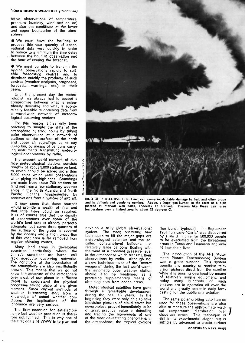
RING OF PROTECTIVE FIRE. Frost can cause incalculable damage to fruit and other cropsand is difficult and costly to combat. Above, a huge gas-burner, in the form of a pipepierced at intervals with holes, encircles an orchard. Burners like these can raisetemperature over a limited area to about 25 degrees C. .
develop a truly global observationalsystem. The most promising newtechniques to fill the major gaps aremeteorological satellites and the so-called constant-level balloons, i.e.relatively large balloons floating withthe wind at a constant pressure levelin the atmosphere which transmit theirobservations by radio. Although nota new technique one of the "secretweapons" during the last world warthe automatic buoy weather stationshould also be mentioned as a
promising supplementary means ofobtaining data from ocean areas.
Meteorological satellites have gonethrough a remarkable developmentduring the past 13 years. In thebeginning they were only able to taketelevision pictures of cloud cover butnevertheless proved immediately to beof great practical value in detectingand tracing the movements of oneof the most devastating phenomena inthe atmosphere: the tropical cyclone
(hurricane, typhoon). In September1961 hurricane "Carla" was discovered
by Tiros 3 in time for 500,000 peopleto be evacuated from the threatened
areas in Texas and Louisiana and only46 lost their lives.
The introduction of the APT (Auto¬matic Picture Transmission) Systemwas a great success. This systempermits any country to receive tele¬vision pictures direct from the satellite
while it is passing overhead by meansof relatively simple equipment, andtoday many hundreds of suchstations are in operation all over theworld and greatly assist in daily fore¬casting for the public and aviation.
The same polar orbiting satellites asused for these observations are alsoable to measure the approximate verti-cal temperature distribution over 7cloudless areas. This technique isstill in its experimental stages but issufficiently advanced to create serious
CONTINUED NEXT PAGE

TOMORROW'S WEATHER (Continued)
discussion of the possibility of reduc¬ing the number of the very expensiveOcean Weather Ships now stationedin the North Atlantic.
Other types of meteorological satel¬lites are placed in stationary positionsover the equator. From a distance of36,000 km. above the earth these
satellites watch the atmosphere per¬manently and provide invaluable data,particularly from tropical areas.
Constant-level balloons have been
tested with promising results in thesouthern hemisphere. One such bal¬loon circled the Antarctic continent
several times, and their average life¬time is 100 days. It is also possibleto use satellites to collect observations
from a large number of constant-levelballoons and automatic buoy stations.
Unsungheroes
who risked
their lives
to an International Cloud Atlas, andso on.
On board several thousand mer¬
chant ships, officers are voluntarilymaking similar observations at thesame standard times. These obser¬
vations must not only be made atstandard times but also regardless ofweather conditions, however severethey may be. In raging snowstormsor the sweltering tropical heat thesebrave people do an exacting job for amodest remuneration. No wonder the
word "heroes" has been used to
characterize them.
Some have given their lives formeteorology. During a severe winterstorm at the Norwegian weather stationat Jan Mayen, the observer neverreturned from a night visit to themeteorological screen which was only20 metres from the hut where he lived.
He must have lost his sense of direc¬
tion and was found the next day frozento death by the blizzard.
The second condition that must be
satisfied if weather forecasting is tobe improved is that data-processingtechnology must provide a rapid meansof dealing with a very large amountof global data.
An example will best explain thereason for this condition and con¬
sequently the importance of modernhigh-speed electronic computers tometeorology. As already mentioned,the basic mathematical equationswhich govern the motions of the atmo¬sphere have been known for manyyears. It has, however, not yet beenpossible to solve these equations intheir most general form and a number
of simplifications and assumptionshave had to be made.
In 1922 the English theoretician,Lewis F. Richardson, devised anapproximate numerical solution tothese equations. The simple deskcalculator, which was all that wasavailable at that time, could not handlethe job. Richardson himself onceworked hard for six weeks to pro¬duce an (unsuccessful) forecast for12 hours; he estimated that 64,000 cal¬culators would be necessary to keepabreast of the changing weatherpatterns.
The high-speed electronic computerhas made calculations of this magni¬tude feasible and they are now used inmany countries to prepare or assist inthe preparation of the prognosticweather maps which constitute thebasis on which forecasts are made.
The World Weather Watch is based
on the most modern techniques of dataprocessing. Each World Meteorologi¬cal Centre prepares meteorologicalcharts for very large areas and distri¬butes them promptly to other world,regional and national meteorologicalcentres.
It is a basic principle of the WorldWeather Watch that each national
meteorological centre has an obli¬gation to collect and disseminate aselection of weather data for use bythe rest of the world. In return, eachnational meteorological centre receivesthe global data it needs and has accessto those products (charts etc.) of theworld and regional centres which arerequired to meet its national commit¬ments.
8
IIT would be a great omis¬sion to discuss the observing systemwithout mentioning the human effort in¬volved. Consider the observers, thoseunsung heroes who provide the basicinformation on which the whole struc¬
ture of meteorology depends.
Their task is one of the most incon¬
venient and modestly paid jobs ima¬ginable. Their duties require them tobe present at fixed hours of the dayand night, on Sundays and publicholidays as well as weekdays. Theymust follow implicitly the procedureslaid down as the result of a hundred
years of international collaboration.
If we imagine that it is now time tomake the next observation, we can
visualize a silent army of some8,000 to 10,000 people of all nationa¬lities, in all climates from arctic totropical, making the same observationsat the same standard hour. They willread thermometers placed in a specialwhite-painted screen, determine thewind speed and direction over aninterval of ten minutes, estimate thecloud cover and cloud type according
What the telegraphhath wrought
HERE remains the third
condition that must be satisfied to im¬
prove weather forecasting efficienttelecommunications. A global telecom¬munication network of higher speedand greater efficiency, is an integralpart of the World Weather Watch plan.
Telecommunications are often called
the "life-blood" of meteorology. Andin this respect two events have hadenormous consequences for the devel¬opment of weather forecasting. Thefirst was, of course, the invention ofthe electric telegraph and its practicalintroduction both in North America
and in Europe in the 1840s. The sec¬ond was a disastrous storm which
caused heavy losses to the Anglo-
French fleet in the Black Sea on Nov¬
ember 14, 1854.
Some time after this storm a detailed
study was made to see whether itcould have been forecast had a
weather service based on telegraphedreports then existed. Napoleon III,who commissioned the study, receivedan affirmative report from Leverrier,and on the same day he gave the"famous French astronomer orders to
organize a telegraphic weather ser¬vice. This soon led to the establish¬
ment of official meteorological servicesin a number of countries includingEngland in 1861, France in 1863 andNorway in 1866.
International interest in meteorology
was growing apace and important in¬ternational conferences were held in
Brussels, in 1853, and in Leipzig, in1872. The first world-wide effort, at
governmental level, to standardize andimprove international meteorologicalactivities was made a century agowith the holding in Vienna of the firstInternational Meteorological Congress,in 1873. From this Congress wasborn the International MeteorologicalOrganization which, in 1951, was trans¬formed into the present WorldMeteorological Organization.
A world-wide telecommunication net
work for meteorological purposes hasbeen in existence for many years andhas been further developed under theauspices of WMO. WWW providesfor a main trunk circuit interconnectingthe three World Meteorological Cen¬tres and appropriate regional centres.This trunk circuit will be of full duplextype and will constitute a closed loop,thus making it possible to transmitsimultaneously in opposite directionsaround the earth.
In 1973 a large part of this circuit isin-full operation. WWW also provides
for regional telecommunication net¬works for the collection of observa¬
tional data from defined Darts of the
world and for its transmission to cen¬
tres on the main trunk circuit. These
networks are used for the distribution
of observation data, analyses andprognoses from world and regionalcentres to national centres.
Telecommunication satellites are
used to provide some of the links inthe global telecommunication systemsuch as Dakar-Paris and India-Aus¬
tralia.
Balloons, buoys and satellitesfor longer-range forecasts
wHAT are the main trends in
meteorological research?
It should be clear from the above
description of WWW that an enormouseffort is being made to build up anefficient world system for exchangeof the weather information used both
for routine daily weather services andfor research.
But our aims and the wishes of theUnited Nations General Assembly gobeyond that. We would like to knowwhether it is possible to forecast theweather longer into the future, for saytwo weeks, with reasonable accuracyand we would like to know whether it
is possible by means of electroniccomputers to predict future climaticchanges and to tell whether suchchanges are natural or caused byman's activities.
These, in brief, are the purposes ofthe Global Atmospheric Research Pro¬gramme (GARP), a joint undertakingbetween WMO and the InternationalCouncil of Scientific Unions.
What do we need to do in order to
extend the forecasts further into thefuture? Do we for instance need
measurements higher up in the atmo¬sphere and do we need to take intoaccount the changes in ocean tem¬peratures?
The first question is relatively simple.The mass of air above say 30 km. isso negligible that in most cases itcan be neglected in the "models" usedin the computer. Likewise it is notnecessary to take into account thephenomena in the higher atmosphere
the ionosphere which is very im
portant for the transmission of radio-waves but Is of no significance forweather phenomena.
On the other hand, although thetemperature changes in the upperlevels of the ocean are much slower
than in the atmosphere and may beneglected in short-range forecasting,such temperature changes must betaken into account when we attemptto make forecasts for more than a
week.
The basic assumption behind GARPis that the day-to-day changes in theweather and also the larger fluctu¬ations, such as the serious droughtperiods now experienced in Africa,are to a large extent controlled byfluctuations in the so-called "generalcirculation" of the atmosphere.
In order to improve our understand¬ing of these processes and to producereliable forecasts for more than three
days we need to do two things:
design the best possible theoret¬ical "models" of the atmosphere andtest them in the computer, and,
arrange "experiments" in theatmosphere to provide the necessarydata for the design of such "models"and test how good they are.
GARP therefore includes a number
of experiments: A GARP Atlantic Trop¬ical Experiment (GATE) will studyspecific tropical problems in 1974 (seepage 21); a Polar Experiment will studythe rôle of the Polar Regions; and theMonsoon Experiment will study theentire monsoon phenomenon from itspre-onset to its full withdrawal.
Finally, a first Global Experiment is
planned for 1977 to seek overall ans¬wers to the questions raised above.As a by-product it is also hoped thatit will assist in determining the mostefficient and economical system ofglobal observations. To be success¬ful, a much denser network than at
present provided by WWW will benecessary.
The Global Experiment using thewhole atmosphere as its laboratorycalls for five geostationary satelliteswhich it is hoped will be provided byU.S.A. (2), U.S.S.R., Japan and theEuropean Space Research Organi¬zation (ESRO). In addition to the usualpolar orbiting satellites, the experimentalso requires a large number of con¬stant level balloons and automatic buoystations to obtain better coverage fromthe tropics and the Southern Hemi¬sphere.
Vast amounts of data from these
sources will be fed into powerfulcomputers and it could be that theyear of the experiment 1977 will bethe year that meteorologists have beenwaiting for during the past 100 years;perhaps the atmosphere will finallydisclose some of its remaining secretsand give the answers to at least someof our questions.
The importance of these globalresearch efforts is well understood
both by the man in the street and bygovernments. It is not necessary toblow the great trumpet of alarm to
obtain support for these efforts since Qit is obviously in the interest of man- ¡Jkind to know more about the behav¬
iour of the atmosphere and the futureof our climate.
CONTINUED PAGE 12


Nature
on the rampage'The most violent of all storms, a tornadois a vortex of rapidly spinning air seenas a funnel-shaped cloud that concealswinds of hundreds of kilometres an hour.
Tornadoes are born where air currents
of different temperature, density andmoisture collide and a mass of cold air
forces its way beneath warm moisture-laden air. Though rarely more than a fewhundred metres wide and averagingspeeds of 40 km. an hour, they leavea swathe of devastation wherever their
whirling tips touch down. Photos left andbelow left record the fearful advance oftwo "twisters" as these storms are called.
Tornado in lower photo reaching earth¬wards from a storm cloud resembles a
rampaging elephant's trunk. Right, space¬craft view of Hurricane "Debbie" photo¬graphed in September 1961 from 160kilometres above the Atlantic Ocean.
Debbie's "eye" the comparatively calmcentre of a maelstrom of spirallingwinds is clearly visible at centre.Unlike tornadoes which form over the
land, tropical cyclones are generallyborn at sea. They bring shrieking windsand torrents of rain when they sweepover coastal areas. Below, rescuers pulla man to safety in Rio de Janeiro duringa tropical storm that hit Brazil in 1965.
©
"*^I^
:.'S'.:->-

TOMORROW'S WEATHER (Continued from page 9)
A trump card
for developing nations
12
M EW subjects figure moreprominently in the daily news than theimperative need to raise the standardof living in developing countries.Despite intensive efforts, it is commonknowledge that the gap between theeconomics of developed and develop¬ing countries is still widening.
To combat this trend ' the fullresources of science must be mobi¬
lized and this includes as a matter of
fundamental importance the appli¬cation of meteorological knowledge toeconomic development, whatever thelevel attained in the country concerned.It is no accident that the countries
with the most advanced economies are
also those making the most use ofmeteorological advice.
In any programme of economicdevelopment, attention must be givento climate and weather. Over the
years it is climate that determinesnatural vegetation, agricultural yield,the abundance or lack of water
supplies and the suitability of differentareas for particular human activities.Weather influences the demand for
power for industrial and domestic use,,the economic operation of dams, thechoice of the best period for farmingactivities, the safety and comfort oftransport services, and many otherfacets of everyday life.
Economists recognize that adequatemeteorological information reducesunnecessary expenditure, helps toavoid the waste of natural resources
and manpower, and is vital to theplanning and implementation of devel¬opment programmes.
The World Weather Watch will helpthe developing nations to take part inand grow with the scientific and tech¬nological progress that is one of itspurposes. It will help to establish theconditions necessary for effective landuse and water resource management.
The new global data expected fromthe WWW will serve to speed up suchwork. For instance meteorologicalsatellites offer many advantages todeveloping countries; in particular theAPT system mentioned above permitsearly warning of devastating storms.
In trying to raise the potential oflow-income countries, many govern¬ments npw realize that the investment
of funds in meteorological work is anessential preliminary to development
projects. For instance, the meteoro¬logist and hydrometeorologist mustfirst acquire weather and waterrecords if they are to avoid the pitfallof building dams at great expense inareas receiving insufficient rainfall.
Surveys and feasibility studies,sometimes sponsored by internationalaid programmes, today provide econo¬mic and technical data on soils, min¬eral deposits, forests and waterresources; on power, transport andcommunications possibilities, as wellas on agricultural and industrialpotential.
No country in the world, whateverits size, can operate an effectiveweather service without information
from neighbouring countries, and even,for many purposes, from a whole hemi¬sphere.
The first proposal to set up an inter¬national fund to assist in establishingspecial stations in remote areas ortelecommunications facilities goes asfar back as 1873 and, it was 90 yearsbefore the idea was generally accept¬able.
Today, in addition to participatingin the United Nations DevelopmentProgramme, WMO has established itsown voluntary assistance programme.Through this programme developingcountries may request assistance toestablish any facility needed for WWWand any country in a position to assistmay offer either equipment or services,or both. Direct financial support isalso possible.
In total, during the last 20 years,WMO has carried out 200 expertmissions, has granted 1,500 fellow¬ships and has provided equipment andorganized training seminars worthabout 53 million dollars. In 1972
alone, the total of WMO's aid pro¬grammes amounted to more than10 million dollars.
The very success of technical co¬operation in meteorology lies perhapsin the fact that it is a truly reciprocalprocess in which developing countriesare playing a full and indispensablerole.
This co-operation also extends to thestudy of world-wide technical andscientific problems which are handledby eight technical commissions cover¬ing all the major branches of meteo¬rology and part of hydrology.
Did
youknow
that...?
w,HAT are the trends in the
application of meteorology to varioushuman activities?
Most people have the impressionthat the most important activities ofmeteorologists, in the sense of econo¬mic benefit to the country, are thegeneral forecasts for the public andthe daily routine services to civil avia¬tion. This is understandable but far
from the truth.
The benefits accruing from meteo¬rological activities, such as specialforecasts for aviation, agriculture andindustry, are not always easy to cal¬culate; is it possible, for instance, toassess the value of human lives? In
spite of such difficulties, comprehen¬sive studies have been made and it
has generally been concluded that thesavings to the national economy aremany times greater than the moneyspent by a country on meteorology.
What kind of human activities
benefit most from meteorological ser¬vices? They vary from country tocountry but it will be a surprise tomany to see the list below which isvalid for a large developed countryand gives the activities in the order inwhich they may benefit from availablemeteorological services:
1) Fishing, 2) Agriculture, 3) Airtransport, 4) Forestry, 5) Construction,"6) Land transport, 7) Water transport,8) Energy production and distribution,9) Merchandising, 10) Water supplyand control, 11) Communications, 12)Recreation, 13) Manufacturing.
Here are some examples of the prac¬tical applications of meteorology.
The effect of bad weather (strong

wind, frost, rain etc.) on industry isobvious when the work takes place inthe open, though manufacturing pro¬cesses and working conditions inindoor industries are also influenced
by the weather. It is the meteorolo¬gist's job to give advice which willenable these effects to be reduced toa minimum. It is estimated that the
annual loss to the United States con¬
struction industry due to weatheramounts to 3,000 million dollars.
In commerce the demand for certain
commodities is greatly affected byweather conditions. The additional
load placed on power supplies in coldspells is a good example of the fluctu¬ating demand, and sales of food (ice¬cream!) and clothing are also greatlydependent on weather influences.Many of the risks against which peopleinsure themselves or their propertyare directly or indirectly related to theweather. The rates of insurance are
often determined on the basis of climo-
tological statistics. Marine and cropinsurance are two obvious examples.
Almost every aspect of agriculture,from the planning of land use to thetransportation of crops, calls for expertmeteorological advice. Areas pre¬viously considered barren can todaybe made productive thanks to a widerunderstanding of the significant meteo-roloqical factors involved in plant
growth.
The social consequences of appliedmeteorology are seldom as plain asthey are in relation to food production.It has often been stated that one half
of the world's population does not getsufficient to eat to maintain normal
health. This horrifyinq figure presentsa challenge that is all the more des¬perate because the explosive growthof population of our times tends toabsorb every increase in productionwithout providing more food per head.
By the year 2000, we are told, therewill be two mouths to feed for everyone today. New sources of food mustbe found and agricultural productionmust reach unprecedented levels ifstarvation is not to assume catastro¬
phic proportions.
In many ways our ability to respondto this challenge depends to a con¬siderable degree not only on openingup new land for crops but also onpreventing the losses which now resultfrom climate and weather. A much
more detailed knowledge of the rangeof climatic fluctuations in food-pro¬ducing regions is necessary, as wellas a thorough understanding of atmo¬spheric processes if damaging weatherconditions are to be predicted farenough ahead.
The implementation of the WorldWeather Watch should enable meteo¬
rologists to play a major part in thefood production campaign by enablingthem to give better scientific advice tothe agriculturalist. A stronger justi¬fication than this would be difficult tofind.
The safe, efficient and regular oper
ation of air, sea and land transportdepends to a considerable extent onthe weather along the route. Theprovision of accurate weather infor¬mation and forecasts is accordingly ofprime importance to these operations.The advent of high-flying jet aircraftand the use of radar and other elec¬
tronic aids have not made this infor¬
mation redundant but have rather
created a demand for more highlyspecialized advice.
The need to divert to an alternative
airport or the effects of clear airturbulence in forcing airliners to reducealtitude also have obvious financial
effects, and the coming introductionof supersonic aircraft flying higher andfaster will make these problems morecritical. It is extremely doubtfulwhether any radical improvement inaccuracy can be expected over manyof the world's air routes until moreinformation is available from them.
The planned global observational
system would furnish this information.
Meteorological information has manyother applications to transport,affecting both its safety and theeconomics of its operation. Theeffects of even relatively minor delayscaused by fog, ice or snow extendbeyond the personal inconveniencethey cause to passengers, resultingin a loss of working hours which canhamper national economic growth.
The transport of perishable goodsby land or sea also depends onspecialized weather information. Ithas been estimated that by 1975 thetotal world freight costs for oceancargoes could amount to $15,000million per year. If better routingalong minimum time paths, thusreducing storm losses, fuel consump¬tion and time at sea, could achievea reduction of only 1 per cent in thesecosts, the annual savings would be$150 million.
Who will be rightin the year 2000?
_ HROUGHOUT history manhas endeavoured to protect himselfagainst unfavourable climatic or wea¬ther conditions. To a limited extenthe has succeeded. Tne heating or air-conditioning of buildings, even thewearing of clothes, are attempts tomodify the climate in which we mustwork and play. Out of doors theplanting of trees or hedges, frostprotection, hail suppression and evenirrigation are all examples of the wayin which artificial influences have beenused to modify the natural climate.
At the same time man has inad¬vertently created changes in localclimate by building large cities andpolluting the atmosphere by theburning of fuels. For many years pastsmall-scale experiments have alsobeen carried out in local weathermodification such as fog dispersal orcloud seeding to increase rainfall, butthe problem of large-scale weathermodification has not been solved.
It is believed that much moreattention will be given to thesequestions in the future and in
particular it would be of enormousimportance if sound advice could begiven to governments on the possi¬bilities of future climatic variations andwhether such variations are natural or
man-made.
The possibility of numerical forecastsfor longer periods, say up to twoweeks, was discussed under GARPabove 'and it is hoped that in 10 to20 years time we shall know whetherthe optimists or pessimists are right.
The potential economic value oflong range forecasting is not the samefor all activities and is not easy toassess accurately. Aviation is notmuch interested in such forecasts but
if farmers-, fuel producers, publicutilities, builders and water managerswere able to make economies of five
per cent only, the probable totalsaving has been conservatively esti¬mated at $5,000 million per year.
The use of natural resources is ..
another area where great progress is 1not only possible but will be essentia! **because of the increasing demands onthese resources.
CONTINUED PAGE 16

North Amer ca's lowest
temperatureC
Snag, Yukon. Canada
Greenland's lowest
temperatureC
Northice
North America's greatest!average annual rainfall
6,655 mm.
Henderson Lake,B.C. Canada.
50 WORLD
WEATHER
RECORDSAntarctica's averageannual temperature
C
Plateau Station, Antarctica
World's lowest
temperatureC
Vostok, Antarctica
Map © Copyright
Adapted from a map prepared by the Earth Scien¬ces Laboratory, Natrick, Mass., and published bycourtesy of the U.S. Army Engineer TopographicLaboratories. Fort Belvoir, Virginia, U.S.A.

TOMORROW'S WEATHER (Continued from page 13)
A global searchfor new energy sourcesand an all-out attack
on air and water pollution
w
16
ATER is life. Not only is itvital to man's physical being but pract¬ically nothing that he undertakes canbe carried out without its use in one
form or another. Weather records are
a prerequisite to an assessment ofwater resources and to the national
planning of water use.
As a low-cost source of power it canconstitute a sound basis for agri¬cultural and industrial growth. At boththe planning and operational stages,the forecasting of weather and floodsis important if efficient and profitableuse is to be made of the available
resources. As an example, a one percent improvement in the spring floodforecasting on the Peace River inCanada will permit an annual savingof one million dollars in the operationof the huge power dam at PortageMountain.
The subsequent development ofriver basins will aid irrigation anddrainage, flood control, soil conser-.vation, navigation and fisheries as wellas the production of hydro-electricpower.
The international programmes inhydrology developed jointly betweenUnesco and WMO will ensure that full
attention will be give to these problemsin the future years.
The idea of using wind and solarenergy as power sources is by nomeans new but is receiving increasingattention partly because these re¬sources are non-pollutant. An essen¬tial prerequisite to future developmentwould be a detailed meteorologicalsurvey of the distribution in both timeand space of wind and solar energy inselected areas and taking into accountthe possibilities of using other formsof energy.
It will be necessary in the future topay more attention to the pollution ofthe atmosphere.
The industrialization of the highlydeveloped countries of the world hasbrought with it new problems for themeteorologist. It is a well-known fact
that the burning of fossil fuels hascreated changes in the local climateof some areas and it is only In recentyears that active steps have beentaken to control the further pollutionof the' atmosphere.
The level of pollution in some placeshas reached a point at which it hasserious social and economic con¬
sequences. The effect on the healthof the population of breathing impureair is generally slow but neverthelesslethal when meteorological conditionsinhibit the transport and dispersal ofthe polluting agents. In the greatLondon smog of early December 1952more than 4,000 people died, mainlyfrom bronchial or chest complaintsaggravated by the toxic air.
This example is, happily, one ofrare occurrence, and active measuresare being taken in many countries toavoid similar disasters; we should not,however, overlook the fact that the
annual toll of illness resulting frompollution costs a great deal in termsof man-hours. The long-term effectsof lower concentrations also constitute
a serious risk to the health of the
public.
A good deal more research intothe relationship between health andpollution will be necessary beforethese effects are fully understood.Meanwhile, more rigorous legislationto control the release of pollutantswill help to reduce the dangers, aswill the planning of towns to ensurethat there is adequate air movementto remove pollution and dispersecontaminants.
Another vital problem for the futureis that the burning of fossil fuel isbelieved to steadily increase theamount of the natural gas carbondioxide in the atmosphere and thatindustrial activities are changing theamount of solid particles present inthe atmosphere. The possible impactof these human activities on the future
climate is now receiving considerableattention.
For the purpose of studying theseproblems the WMO has establisheda world-wide network of "background"pollution stations which are placed faraway from industrial areas and whichare monitoring certain pollutants andgases in the atmosphere. In thefuture the measurements from these
stations will play a major rôle whenstudying changes in climate.
M INALLY, one of tKe funda¬mental problems for the future is theclear trend towards a greater auto¬mation of all meteorological work andthe increasing dependence on meteo¬rological satellites to obtain globalobservations. The automation of
observations, plotting of charts, cal¬culation of future weather charts, etc.,is a gradual process which changesthe work of many people but createsno basic problems.
On the other hand, the greateruse of satellite observations could
mean that important global observingfacilities will be dependent on thenational plans of a few powerfulcountries or group of countries. Whilethere is no reason to believe that this
powerful position of a few countrieswill be misused in the future, it is mostlikely that future satellite systems willbe based on a broader participation byall benefiting countries through WMO,the responsible international organi¬zation.
There is no doubt that the World
Weather Watch and GARP will have
a great impact on future developmentsin meteorology. For several gener¬ations the countries of the world have
endeavoured to develop the scienceof meteorology without having adequatetools to do the job. We still do nothave all the tools necessary but atleast a great effort is now being madeto state in detail what is required interms of observations, equipment andpersonnel.
It would be premature to try todefine the full consequences of WWWand GARP, but a great deal willobviously depend upon technologicaldevelopments now in hand and thoseto come in the next few years. Ifthey prove capable of meeting thecomplex demands placed upon them,and if the spirit of internationalcollaboration continues to prosper andgrow, the realization of these greatscientific projects could be within ourgrasp.
At least it is certain that the age-old desire of mankind to harness theforces of nature will continue to be
a driving force and the World Weather -Watch and the Global AtmosphericResearch Programme are naturalsteps in this direction. We may there¬fore be optimistic about the out¬come which will, inevitably, bringchanges affecting the way of life ofeach one of us. >
Kaare Langlö

Weather research
sounding-balloons, herebeing filled with he¬lium, a lighter-than-air, non - Inflammable
gas, are able to driftfor hours at heightsbetween 25 and 40
kilometres, where thereis no risk of them
encountering eitherhigh altitude jets orearth-circling satellites.These explorers of thestratosphere carry mea¬suring instruments torecord air pressureand temperature, windspeed and directionand other weather in¬
formation. Their mis¬
sion accomplished, theinstruments parachuteback to earth.
IS THE EARTHS
CHANCING ?
For the past 30 yearsthe temperature of our planethas been steadily dropping
by Hubert H. Lamb
CLIMATE
HUBERT H. LAMB of Great Britain is an international authority on thelong term processes of climatic change. He is director of the ClimaticResearch Unit at the University of East Anglia (U.K.) and for manyyears has been actively engaged in international research on climate,in particular polar meteorology and the study of climatic fluctuations.Among his many writings are "The Changing Climate" (1966) and,most recently, "Climate: Present, Past and Future", a major studyof which Volume I, "Fundamentals and the Climate Now" appearedlast year (Methuen, London; Barnes and Noble, New York).
LT the beginning of thiscentury, and right up to the SecondWorld War, the accepted view in cli¬matology was that, though there hadbeen significant changes of climate inthe geological past ice ages andinterglacial periods somewhat warmerthan now (not to mention the manymillions of years of the Earth's historyin warm geological eras with little orno ice even at the poles) climatewas now essentially constant and hadbeen so for at least the last two thou¬
sand years.
Descriptions of the climates of Brit¬ain, Germany and southern Russia byRoman and Greek writers fn classical
times were so similar to the impress¬ions of visitors from the Mediterranean
countries in modern times that theyseemed to prove the point : evidentlynobody stopped to think that the coun-
CONTINUED NEXT PAGE
17
Rain and snow to order?
IS OUR CLIMATE CHANGING ? (Continued)
18
tries at both ends of the journey mighthave been either colder or warmer
than now.
Granted the variations of weather
from one year to another producedalternate times of ease and difficultyand occasional disasters, but these
were taken to be just random variationsabout the mean or, at most, the prod¬uct of cycles of no more than a fewyears or decades duration (and some¬what capricious amplitude).
Hence, any table of climatic statisticscomprising the weather observationsof 30 years or more was thought to bean adequate basis for future planning(and even for the calculation, by refinedstatistical methods, of such rare
hazards as the extreme flood or gustof wind, or the severest frost, to be
expected once in 100, 200 or 500years).
This view and these methods gotinto the standard textbooks, and were
taught in schools and universities tothe generation now holding the posi¬tions of responsibility in governmentand industry in most countries. Themethods were, of course, sound
enough, provided the series of obser¬vation data were really adequate tothe purpose in mind; but this has cometo be seriously questioned. In manyareas the methods are still in use,
pending a better understanding of cli¬matic trends and changes.
The need for a reassessment has
become clear for a number of reasons.
Computations in the United States
from surface air temperature observa¬tions all over the world show that from
the 1880s to some time after 1940 the
Earth's climate was becoming generallywarmer. The global warming overthose years amounted to about half adegree Centigrade, but in the Arcticit was much stronger and amounted toseveral degrees between 1920 and1940.
The ice on the Arctic seas decreased
in extent by about 10 per cent anddecreased in general thickness byabout one third. Glaciers in all partsof the world were receding, openingup new pastures and land for cultiva¬tion, while the melt-water swelled the
flow of the mountain rivers in springand summer.
The greater warmth increased thelength of the growing season by twoto three weeks in England. The wildflora and forests, the cultivation of
various crops, and the ranges of sea¬sonal migration of birds and fish, allspread to new regions under the in¬creasingly genial conditions.
Mankind takes naturally to easierconditions. Old habits of wearingheavy clothing and laying in foodstocks for the winter in northern lands
were more and more given up, andoften unkindly attributed to the outmod¬ed mental attitudes of the nineteenth
century, while the climatic improve¬ment affecting most of the developedcountries in temperate (and higher nor¬thern) latitudes passed unnoticed forsome time.
Once the climatic trend was noticed,
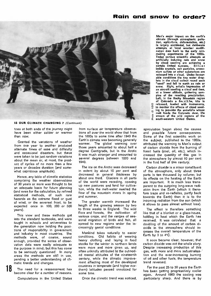
Man's major impact on the earth'sclimate (through atmospheric pollu¬tion, agriculture, deforestation, etc.)is largely accidental, but deliberateattempts at local weather modifi¬cation date back to the early rain-making experiments of the 1890s.Today serious scientific attempts atartificially inducing rain and snowby cloud seeding are achieving acertain limited success. Silver
Iodide crystals, salt particles, ammo¬nium sulfate or other substances are
released into a cloud. Under favour¬
able conditions the tiny water drop¬lets in the cloud collect round each
"seed" and fall to earth as rain or
snow. Right, artist's impression ofan aircraft seeding a cloud and then,at a lower altitude, gathering sam¬ples of the resulting precipitation.Left, in the Rocky Mountain regionof Colorado a 6m. X 3.7m. kite Is
52 released, loaded with instruments,
p to monitor the effects of cloud seed-Q ing to provoke the snowfalls whose~ melt feeds the Colorado river, lifeS stream of the arid regions of the£ south-western United States.
speculation began about the causesand possible future consequences.Some of the first scientific work on
the subject, published in the 1950s,attributed the warming to Man's outputof carbon dioxide from the burning offossil fuels (coal, oil, etc.), which in¬creased the quantity of this gas inthe atmosphere by almost 10 per centin the first half of this century.
Carbon dioxide is a minor constituent
of the atmosphere, only about threeparts in ten thousand by volume; butits effects on the heating of the Earthare important. It is much less trans¬parent to the outgoing long-wave radi¬ation from the Earth (which it there¬fore traps and re-radiates, partly backtowards the Earth) than it is to theincoming radiation from the sun (whichit allows to pass almost without loss).
The effect is therefore somethinglike that of a blanket or a glass-house,holding in heat which the Earth hasreceived. It was calculated that a
doubling of the amount of carbon di¬oxide in the atmosphere should in¬crease the overall temperature of the
Earth by 3 to 4°C.
It soon became clear, however, that
carbon dioxide was not the whole story.Despite increasing production of thisgas, with more and more industrializa-^tion and the ever-increasing burningof oil and other fuels, the temperaturetrend reversed.
For the past 25 to 30 years the Earthhas been getting progressively cooleragain. Around 1960 the cooling wasparticularly sharp. And there is by

now widespread evidence of a corres¬ponding reverse in the ranges of birdsand fish and the success of crops andforest trees near the poleward andaltitudinal limits.
Moreover, the longest temperaturerecords available in various northern
countries from the early eighteenth cen¬tury (in England from the late seven¬teenth century) showed that the prev¬ious warming had a very long history,traceable from the beginning of therecord through various shorter-termups and downs.
This meant that the warming beganbefore the industrial revolution and
could not be altogether attributable tothe effects of human activity.
Thus, quite recent climatic trendshave forced us to recognize that cli¬matic changes and fluctuations areforever going on, even in our owntimes, and that we have to reckon
with changes brought about both bynatural causes and the actions of Man.
The decline of prevailing temperaturessince about 1945 appears to be the
longest-continued downward trendsince temperature records began.
In face of this and the many new
types of pollution put into the atmos¬phere by industrial processes, bombtests, high-flying aircraft, rockets andso on, the question of what we shouldexpect the climate to do next is oftenasked but is not easily answered, andthe improvement of knowledge andunderstanding has become an urgenttask.
Investigation readily shows that the
general wind circulation over theglobe undergoes continual variationsof vigour and to a certain extent ofits basic pattern. The variations rangefrom great predominance of the"zonal" westerly and easterly cur¬rents to considerable prominence of
"meridional" (southerly and northerly)flows which are accompanied by sta¬tionary "blocking anticyclones" atcertain longitudes straddling the mid¬dle latitudes zone that is normally thezone of prevailing westerlies.
HESE changes are the "me¬chanism" by which climatic changesare brought about, whatever the ulti¬mate causes may be. And the effectsare by no means confined to tempera¬ture and the extent of snow and ice.
Among the successive 10-year aver¬ages of yearly precipitation in manyparts of the world, let us examinesome figures from about 1840 forBarnaul (53° N 84° E) in the heartof Asia.
The decades of global warming inthe early part of this century werea time of abnormally maintained vigourof the 'zonal wind circulation, and theyseem to have been marked by excep¬tional transport of moisture-bearingwinds from the Atlantic all across
Europe and onwards as far as thisarea of central Asia.
In previous deaades in the nine¬teenth century and again after 1950,the precipitation at Barnaul was lessby a substantial percentage. As the
average annual downput of rain and
snow beween 1900 and 1940, equi¬valent to a rainfall of 482 mm. peryear, was just sufficient for agriculturewith careful management and someartificial irrigation, the provision ofenough water in that region, as in otherparts of the world, in the long termraises anxious problems.
With the rising population of SovietCentral Asia, and increasing industrialneed for water as well, the authorities
have been obliged to consider divert¬ing water from the great rivers ofSiberia which flow north to the ArcticOcean.
This proposal is one, however,which demands a more exact under¬
standing of the large-scale processesof climate than is so far within our
reach. If it is undertaken, it will have
to be attempted in very limited stagesand with a careful watch on possibleside-effects on the grandest scale.
This is because it is the water of
the Siberian rivers which largely pro¬vides the ice-bearing layer of lowsalinity on the surface of the ArcticOcean : if that ocean were converted
into a normal salt-water ocean with
an open surface free of ice, most of
the Arctic would be on average 10 to20°C warmer than it now is (and over30°C warmer in the winter time).This change could alter the whole pat¬tern of the wind circulation, and hence
the distribution of rainfall, over the
northern hemisphere.
A recent experiment (by R.L. New-son, in 1973) with a mathematical
"model" of the atmospheric circulationsuggests that the winters would be¬come colder over the northern hemi¬
sphere landmasses in middle latitudes.And other studies (by a Soviet scien¬tist, O.A. Drozdov, in 1966) have sug¬gested, apparently in agreement withthis, that the rain and snow-bearingcyclonic disturbances would be largelydiverted into the Arctic, leaving manycontinental regions drier than before.
This problem of the water neededin the arid lands in central Asia is one
point (and there may be others) atwhich our understanding of climatebecomes involved with the human
population explosion and presents
mankind with a dilemma which may bevery hard to solve.
The great internationally organizedobservation network set up by theWorld Meteorological Organization inthe World Weather Watch (WWW,see article page 4) involving the use _of satellites and many fixed observa- 1 Qtion points in all the world's oceansas well as in Antarctica, greatly im¬proves our ability to monitor the symp-
CONTINUED NEXT PAGE

IS OUR CLIMATE CHANGING? (Continued)
toms of climatic change as they occurand wherever they are most clearlyseen.
And the Global Atmospheric Re¬
search Project (GARP, see article page21) scheduled by WMO for the mid-1970's should improve our understand¬ing of the large-scale atmosphericcirculation and its interactions over
the whole globe.
But there is a great need also toestablish the facts of the past recordof climate in as much detail as pos¬
sible, to give climatology the longestpossible observation base for inves¬tigating the natural climatic fluctuat¬ions and their causes. Moreover, the
causes are known to go beyondmeteorology as ordinarily understood.To identify them, and indeed to re¬construct the facts of the climatic rec¬
ord in past centuries and millennia,will ' entail an exciting collaborationbetween many branches of scienceand learning.
The measurements of the strength
of the incoming solar radiation avail¬able from 1883 to recent years show
very clearly the effects of greatvolcanic eruptions which put up per¬sistent veils of dust into the high
atmosphere in 1883, 1888, 1902, 1912and 1963.
From comparison of the tempera¬tures and wind circulation patterns
prevailing in the years immediatelyfollowing these and other great vol¬canic explosions in the eighteenth andnineteenth centuries, the effects upon
climate, though temporary, are seento be real and in some cases drastic.
B
20
'UT there has been a gradualdecline in strength of the solar beamsince 1945 which may have to beattributed to the sun itself. There is
probably no need for undue alarmabout this, because similar changes
affecting climate and of the globalwind pattern appear to have occurredmany times before and what we arewitnessing may be a recurring fluc¬tuation of the solar output, apparently
tending to repeat itself at about 200or 400-year intervals. The effectsare, however, likely to be world-wideand to pose awkward problems wher¬ever we are exploiting climatic resour¬ces (such as water or summer warmth)to the limit.
Records exist of the number of
days each year from 1861 to 1970when the general zonal current of thewesterly winds of middle latitudes hasswept across the British Isles. Par¬ticularly noticeable are the high fre¬quencies sustained between about1902 and 1938, at the height of theglobal warming, and the marked de¬cline in recent years to previously
unrecorded low levels in 1968 and
1969 (and again in 1971).
Other records present the 600
year-long history of the frequency ofthe south-westerly surface wind ineastern England (based upon variousdata, including an early weather diaryabout 1340, and strictly daily obser¬vations in London from 1669).
They broadly parallel the record ofwesterly winds in the last hundred
years and seem to indicate a markeddecline of the westerlies, as in recent
years, recurring at about 200-yearintervals.
Apart from their possible ultimateorigin in a long-term fluctuation of thesolar energy available, linkages havebeen demonstrated between the
changed patterns of the atmosphericcirculation and corresponding persist¬ent anomalies in the circulation of the
oceans.
Because large volumes of warmeror colder than normal sea water
cannot be reduced to normal at all
quickly, these have persistent effectson the wind circulation which are
useful in forecasting.
Among the effects of the changesof climate and the wind circulation in
recent years which have given causefor concern are :
a renewed increase (especially
since 1961) of the Arctic sea ice,which has created difficulties on the
northern sea routes in Soviet and
Canadian Arctic waters and has pro¬duced some bad seasons on the coasts
of Iceland and Greenland.
a substantial rise, also- since 1961,
in the levels of the great lakes ineastern equatorial Africa and, more
recently, of the Great Lakes of NorthAmerica;
some 200-year extremes of tem¬perature in individual cold winters invarious parts of the northern hemi¬sphere (and probably also in thewarmth of summer in 1972 in northern
European U.S.S.R. and Finland).
The most serious effects, however,
have probably been the long-continu¬ed droughts and deficient rainfalls invarious parts of the world associatedwith shifts of the world's anticyclonebelts.
Observations have shown changes
of prevailing atmospheric pressureover the northern hemisphere in the
1950s and 1960's compared with the
averages of the first forty years ofthe century. Pressure became higher,and the situations therefore frequently
anticyclonic and drier, over most ofthe Arctic, particularly the Arctic fringethe change amounting to + 3 millibarsover part of Greenland.
A belt of lower pressure than before
in middle latitudes, particularly near40°N (where the change was minus2 millibars in some areas), marks a shiftof the main cyclonic disturbances andrainfall towards lower latitudes than
before. (There was also some increaseof cyclonic disturbances in the innerArctic, near the pole.)
HE subtropical anticyclonesassociated with the desert belt were
correspondingly displaced somewhattowards the equator, and the equa¬torial rainbelt seems to have been re¬
stricted in the range of its seasonalmigrations. In consequence, rainfallincreased in Africa close to the equa¬tor, causing the lakes to rise, while
drought began to afflict places nearerthe fringe of the desert belt, no longerreliably visited in summer by "equator¬ial" rains.
Rainfall at eight places in northernIndia, the Sudan and at 16 to 20°N in
west Africa averaged 45 per cent lessin the years 1968-72 than in the 1950's.
In all these areas people have beendriven from their homes by the con¬tinued failure of the rains, and in theCape Verde Islands at the same lati¬
tude in the Atlantic an emergency wasdeclared in 1972 because of the last
five years of drought.
There are indications that corres¬
ponding shifts have taken place inthe anticyclone and cyclone belts ofthe southern hemisphere and that thedroughts affecting Zambia, Rhodesiaand parts of the Transvaal in recent
years are essentially part of the samephenomenon.
Since 1970 the area of increased
cyclonic disturbance in the inner
Arctic has grown in size, and the beltof increased pressure and more anti-cyclonic influence has expanded toembrace most of the zone between 45
and 70°N, where droughts may alsobe serious to the many densely popu¬lated countries.
At the same time, the shifting posi¬tions from month to month, and from
one year to the next, occupied by themain anticyclone centres in this belt
have introduced an abnormal variabilityof temperature and precipitation. Asimilar development may explain thesequence of droughts and floods indifferent parts of Australia in 1972-3.
All these events have raised an
anxious demand for ultra-long-rangeforecasting of climate, which calls forintensified effort towards understand¬
ing of the atmosphere (and its inter¬actions with the ocean) and for furtherreconstruction of the facts of the pastclimatic record.

Disasters such as this shipwreck, in which13 men lost their lives when their ship ran
aground in a sudden gale, may perhaps bea thing of the past when the results ofGATE, the vast international hydrometeoro-logical research project in the tropicalAtlantic, beginning in June 1974, are known.The project will provide a wealth of newinformation on the movement of atmo¬
spheric disturbances over both land andsea and will enable new methods of
forecasting and Influencing them to bedeveloped.
Photo Tom Smith. Observer - Camera Press 45 Panmage. Paris
OPERATION CATE
35 countries assemble a scientific
armada to study atmospheric phenomena
in the tropical Atlantic
by Yuri V. Tarbeev
YURI V. TARBEEV Is Deputy Director of theInternational Scientific and ManagementGroup (ISMG) of the GARP Atlantic TropicalExperiment (GATE) described in this article.He is a member of the WMO Commission
for Marine Meteorology and of the Internat¬ional Co-ordinating Group for the PacificTsunami Warning System Dr. Tarbeev hasheaded a number of océanographie researchexpeditions.
one-hundred day inter¬national scientific experiment to inves¬tigate the atmosphere and ocean inthe tropical zone of the Atlantic, andof Africa and Central America is due
to begin on June 15, 1974. Knownas GATE (1) (GARP Atlantic TropicalExperiment), the operation will beunprecedented in its scale andscientific significance.
(1) GATE is being carried out under theGlobal Atmospheric Research Programme(GARP), the far-reaching international re¬search project jointly planned by the WorldMeteorological Organization and the Inter¬national Council of Scientific Unions. (Seepage 9)
For the first time in history, 35 coun¬tries of Africa, Europe and Amer¬ica are to join forces in a vast pro¬gramme of atmospheric and oceano-graphical research concentrated overa relatively small area of the earth'ssurface.
More than one hundred meteorolo¬
gical stations, located in the tropicalareas of Africa, on islands in theAtlantic and in Latin America, over 25research vessels, dozens of ocean
buoys, 11 aircraft equipped as flyinglaboratories and several orbiting andgeostationary earth satellites will beoperating according to a synchronized
CONTINUED NEXT PAGE
21
OPERATION 'GATE' (Continued)
5,000 deaths each year from tropical hurricanes
22
single scientific programme and plan.Over 3,500 persons will be engagedin the programme of observations.
The results will be immediately trans¬mitted back to Dakar (Senegal), wherean operations control centre for theexperiment is to be set up, to theWorld Data Centres in Washington andMoscow, and to Bracknell (U.K.), Parisand Munich (German Fed. Rep.) aswell as to other cities. At these
centres, the data obtained during theexperiment will be processed bycomputer.
When the experiment has been com¬pleted, the results will be analysedby dozens of research institutes, labo¬ratories and universities in France, the
Fed. Rep. of Germany, U.S.S.R., U.S.,U.K., Canada and other countries.
Hundreds of experts from differentcountries are today working on thescientific programmes and plans forthe full-scale launching of GATE inJune 1974. To co-ordinate this work,
the World Meteorological Organizationand the International Council of Scien¬
tific Unions have set up an Inter¬national Scientific and ManagementGroup.
Between June and August 1972, inpreparation for GATE, the Soviet Unioncarried out a one-nation "rehearsal"
of the experiment, with the partici¬pation of six research vessels and anaircraft. This expedition discovered anumber of previously unknown featuresof the atmospheric processes in thetropical Atlantic and also produced im¬portant data which will be used inplanning the global experiment.
A^TkN international rehearsal of
the tropical experiment is being held(August 1 to 10, 1973), in the WesternAtlantic.
Two Soviet research vessels, "Aka-demik Korolev" and "Ernest Krenkel",the U.S. vessel "Researcher" and the
Mexican ship, "Cadete Virgilio Uribe"will rendezvous at a point 20° northernlatitude and 60° western longitude tocarry out joint research. Their missionis to make an "intercomparison test"of various instruments and observation
systems to be used for measurementin the stratosphere, atmosphere andocean, to work out uniform observationmethods and to get the necessary ex¬perience in the organization of jointocéanographie work by vessels fromdifferent countries.
In the first fortnight of August 1973,whilst work continues at sea, the net¬work of land-based stations and tele¬
communication links in Africa and
Latin America are being checked out.The purpose of these two internationalrehearsals in 1973 is not simply to
compare instruments and to work outjoint operations for the vessels involv¬ed, but also to solve a certain number
of scientific problems.
It may be wondered why so muchattention is being paid to the veryearly stages of preparation for GATE.There are several reasons.
Firstly, there are likely to be manymore experiments of this kind whichhelp to solve practical scientific prob¬lems but which are expensive anddifficult to organize.
Until recently, meteorological re¬search in the oceans was mainly des¬criptive in character or else was in¬tended to solve specific problems ofatmospheric physics. Scientists, ofcourse, were well aware of the im¬
portance of the need for an integratedapproach to the problem, but the requi¬site technical and material resources
for carrying out such international ex¬periments were lacking.
For instance, in order to obtain amathematical description of the com¬plex physical processes in the atmo¬sphere which govern the weather,with all their interrelationships, a largenumber of simultaneous observations
have to be carried out, employingsatellites, aircraft and large numbersof research vessels.
It is not a practical possibility forany country, even the most economi¬cally advanced, to carry out such re¬search single-handed. The joint effortsof many countries are needed, andthere must be a common interest in
the results of the experiment and mu¬tual agreement to carry out the obser¬vations simultaneously on the territoryof all the countries concerned and at
sea. Without powerful computers itwould be impossible to deal with theflood of information produced by suchexperiments.
Today, the practical conditions forthe success of the operation have beenfulfilled.
Secondly, and this is perhaps themost important factor, GATE has at¬tracted considerable attention because
of the need to find more reliable
methods for weather prediction, long-range forecasts in particular.
The present rapid growth of industryand agriculture gives increasing eco¬nomic importance to long-term fore¬casts, since early warning of such nat¬ural disasters as droughts or severewinter conditions, combined with mod¬ern facilities for operational planning,can considerably reduce the losseswhich they cause and their other harm¬ful consequences.
But if industry and farming are to beplanned on the basis of such forecasts,the predictions have to be reliable.Reliable forecasting methods can beestablished using numerical models ofatmospheric circulation which describe
all the major factors in the state ofthe atmosphere and its relationshipwith the underlying surface of the landand the oceans.
Such mathematical models as these
cannot be drawn up without a de¬tailed study of the processes occurringin the tropics. This is because thesurfaces of the land and the oceans
in that area store up a great part ofthe solar energy which reaches theearth. The processes taking place inthe tropics thus have a considerableinfluence on atmospheric circulationas a whole.
The research which is to be carried
out during GATE will provide vital ex¬perimental material for a far-rangingassessment of the processes occur¬ring in this area and will help to ex¬plain how and to what extent theyinfluence the weather and the climate
in other regions of the world.
M^ INALLY, some processessuch as convection (the upward move¬ment of warm, moist air), evaporationfrom the surface of the oceans, theformation of cloud systems, etc., whichare of fundamental importance for theatmosphere as a whole, are particu¬larly marked in the tropical zone. Byinvestigating them there it will bepossible to discover the physicalmechanism which governs them morequickly and more easily.
Until this physical mechanism is pro¬perly understood, it will be impossibleto deal with such practical problemsas artificial rain-making or the use ofartificial means to reduce the destruc¬
tive force of tropical hurricanes. Apractical example can illustrate thecapital importance of solving theseproblems.
Tropical hurricanes and the floodingwhich accompanies them cause morecasualties and more damage than anyother natural disaster (for a generalarticle on typhoons and hurricanes seepage 52). It has been reckoned thatin the hundred years between 1870and 1970, they caused on average1,500 million dollars worth of damageand more than 5,000 deaths per year.
Out of the world total, the countriesof Asia and the Far East sufferedlosses to the tune of 950 million dol¬lars a year, the countries of the Carib¬bean and the United States about400 million dollars and the countrieson the south-western shores of theIndian Ocean about 46 million dollars.
The heaviest losses were suffered bythe economically developed coun¬tries the United States and Japanwhose losses totalled about 1,000 mil¬lion dollars a year more than 66 percent of the total.

Automatic ocean weather buoys are impor¬tant links In the World Weather Watch
meteorological network. Dozens of thesegiant buoys are to be used in the forthcom¬ing tropical Atlantic research project.
According to the secretariat for theinternational Typhoon Committee, setup under the auspices of the U.N.Economic Commission for Asia and the
Far East and WMO, 22 countries inAsia and the Far East during the per¬iod 1961-1970 suffered damage ave¬raging 930 million dollars a year fromhurricanes and typhoons. This figureis equivalent to the total amount paidout annually to these countries by theInternational Bank for Reconstruction
and Development.
The losses caused by tropical hurri¬canes are a heavy burden on the eco¬nomies of many countries, particularlythe developing countries. Althoughconsiderable progress has been madein forecasting and in providing earlywarnings of the approach of hurrica¬nes, the losses suffered by manycountries at present total five percent, or even more of the national in¬come.
In this connexion, it is interestingto look at a breakdown of these losses
by years for countries with differentlevels of economic development. Los¬ses due to hurricanes in the United
States during the period 1915-1924amounted on average to only 63 million
dollars. Thus in the last fifty yearsthe scale of these losses has increased
by 473 per cent, a yearly average in¬crease of 9.5 per cent which isabout twice as high as the rate ofgrowth of national income. In the 25years beginning in 1945, the cost ofdamage caused by typhoons in Japanincreased from about 273 million to
600 million dollars a rate of growthof about 6 per cent per annum.
In the Caribbean countries, the costof hurricane damage increased in thecourse of ten years from 33,200,000 to92,900,000 dollars, i.e. an increase of
18 per cent per annum, which is nearlythree times the rate of growth of thenational income. Similar trends are
noted in the Philippines, Taiwan andother places.
The increasing cost of such damageis due to intensive economic develop¬ment in the areas affected by hurri¬canes and typhoons, the main factorbeing the rising cost of constructionand the growing number of technicalinstallations being built, and these arereasons which will continue to hold
good in the future.
This means that unless radical solu¬
tions to the problems of tropical hurri
canes are found, the time will come
when the cost of damage will drawlevel with the figure for the growth ofthe national income in other words
cancelling out any progress.
To prevent such a situation fromarising, we must seek new ways ofdealing with the problem. In otherwords, we must develop scientifictechniques for preventing hurricanes.
Such methods will undoubtedly befound, along with methods for makingclouds shed their rain and techniquesfor influencing other meteorologicalphenomena, since many atmosphericprocesses are of a similar physicalnature.
The GARP Atlantic Tropical Experi¬ment is certain to produce numerousobservations which will throw much
light on the physical nature of atmo¬spheric processes, in large and smallscale terms. This will mark a decisive
step in the development of effectivemeans of influencing such processes.
Since hitherto only a few ships haveusually taken part in ocean expeditionsto investigate the atmosphere and thehydrosphere, the results obtained havegiven only a very approximate idea ofatmospheric and < oceanic processes.The forthcoming "tropical experiment,however, will simultaneously cover thewhole tropical zone of the oceans andthe surrounding land areas of Africaand Central America.
It will thus be possible to follow thedevelopment of atmospheric processesand the movement of atmospheric dis¬turbances over land and sea alike, and
hence to determine on a large scalethe influence of the ocean on these
processes.
At the same time, 15 ships, a largenumber of data buoys, more than tenaircraft and several tethered balloons
will be concentrated in a smaller area
of more intensive observations in an
area covering about 800 by 800 km. tothe south of the Cape Verde Islands.They will keep constant watch on theatmosphere in this area when the mostinteresting phenomena are occurring.
All this should provide material of fk_unique value for the solution of present JAand future problems of hydrometeoro- **logy, and should pave the way formany scientific discoveries.

Artificial satellites and high-speed computers, coupled with the morerecent development of relatively inexpensive ground receiving equipmentknown as Automatic Picture Transmission (APT), have revolutionizedinternational meteorology. Direct reception of weather information in the
form of photographs covering an area of a radius of 1,600 km. aroundthe receiving station is now within reach of every country in the world.'Right, antenna of the European Space Research Organization (ESRO)satellite tracking station at Redu, Belgium.
MAKING
THE WEATHER
PAY OFF
An international report reveals
the important changes
meteorology is bringing
to economic and social development
MRvw
Wi\\\W w
wjyjto Ä«
!PP-V
**
rV>r]rrriil7TTi
4M.
H
by Dan Behrman
24
DAN BEHRMAN is a Unesco science writer.He Is the author of 'The New World of theOceans' (Little Brown and Co., Boston,U.S.A.) also published in a paperback edi¬tion, and 'In Partnership with Nature: Unescoand the Environment", Unesco Paris, 1972.His latest book, "The Man Who Loved Bi¬cycles', has just been published by Harper'sMagazine Press, New York.
u.'NLIKE someone in an¬
other profession, the meteorologistcannot bury his mistakes. They arethere for all to see and suffer: therain that drenches picnickers on a "fairand warmer" Sunday; the forecast ofchill that leaves vacation resort oper¬ators fuming under a hot sun with theirrooms empty. When such thingshappen, the weatherman gets theblame and his reputation suffers.
A great deal to change this imageis to be found in a new technical
publication issued by the World Met¬eorological Organization on the appli¬cations of meteorology to economicand social development. It is a reportby the panel that WMO's ExecutiveCommittee set up to look at thesubject.
There are two ways that meteorologycan change the odds in the greateconomic game that man plays withnature. It can predict what nature
will do, the equivalent of giving the

m **»
¡EJE*IBS» '¿20 ^asus
&ÄX»
\VA\VW* »«».
8KV
^5S0*&' O*
- .,
Mm
WW
.
...r**«.*«*. ffAV
. r.y.w.-
. :" f.V.V."....
-
«'ifiliiyiiiWiliX'iliii'igrjffla
.V.V.V.V..V.V
P,v£',\\\
* >
iVtVrVïVyY"^:^'^' »777',*.*.
: 1 1 1 1 i'iy/i'^rXw L^Pvv^>-rt1'rtStrr rwfrf fT1 ttfttffti
punter inside information on a horserace. Or it can try to manipulatenature so that, in effect, our bettor
has a sure thing. The WMO gives usan idea of how far we have come
towards foretelling and changing theweather two of man's oldest dreams.
James McQuigg, an American re¬search meteorologist and professor ofatmospheric science, produces a host
of examples to show how accurateweather forecasts can pay off. Para¬doxically, the more developed an eco¬nomy, the more weather-dependent itmay be. The effects of nature'swhims are extremely expensive whenlarge capital investments are involved.
A good case is the routing of shipsacross the North Atlantic. The cost
of producing a recommended route isabout that of running a medium-sizedtanker for half an hour. Since the
forecast may save from four to twelvehours on a voyage, the shipowner gets
his money back eight to twenty^fourtimes over.
Ships eat up money in harbour. Ifdockers are called out to unload deck
Cargo from a freighter in New Yorkharbour and rain starts to fall, theycannot work safely. But they must bepaid a minimum which can amount to
$3,000 or $4,000 for one day. Onthe other hand, it costs $5,000 a dayto keep a ship in dock with no oneunloading it. In New York harbour,a good weatherman earns his pay.
He does on the Missouri River, too,between Kansas City and St. Louis.A river forecast centre in Kansas Citycan predict river levels from one to
three days in advance. This is pre¬cious information to skippers of tow-boats hauling barges on the Missouri.They cannot use memory and instinctto get over snags and sandbars theway Mark Twain and his fellow pilotsdid a century ago.
When the Missouri is low, every
*ftNESCc>
extra inch of draught means morecargo and a gain of $125 per bargeon the 400-kilometre run from KansasCity to St. Louis. If the forecastercan safely predict a rise of two feetabove minimum flow, then a towboat
can take half again as many barges.
As one might expect, farmers aregood customers for weather informat¬
ion. The more they modernize, themore they need it. McQuigg tells usthe implications of the Green Revo¬
lution and the new varieties of cropsit has introduced
"Old locally-developed maize varie¬ties in Kenya apparently had a broaderspectrum of genetic characteristics,resulting in less uniform sowing-mat¬urity requirements (and lower yields).The climatological information thatproved to be directly applicable wasidentification of two maximum rainfall
periods during the growing season,with the recommendation that two
plantings be made, each using a strain
CONTINUED NEXT PAGE
25

MAKING THE WEATHER PAY OFF (Continued)
A breakthrough in airport fog dispersal
underground jet engines
of maize with a short growing period.
"In some areas, this resulted in a
nine-fold increase in yield."
On the Mississippi Delta in theUnited States where cotton is king,a different need arose. In the old
days when cotton was planted byhand, it had to be replanted if a cold
snap struck. Then came mechaniza¬tion and higher costs that madereplanting more expensive.
Meteorologists found that a cottongrower could cut his risks if he knewthe actual soil temperature at plantingdepth and then used the five-day tem¬perature forecast for his region. Mc¬Quigg estimates that farmers in south¬east Missouri saved about $500,000
a year using information that cost$25,000 to produce.
N
26
I EW techniques mean newproblems, particularly when animalsare kept indoors. The climatologist isnow called upon to assess the prosand cons of air-conditioning dairycattle to see if higher yields are worththe added cost (the answer, accordingto McQuigg, varies from one place toanother).
Animals raised indoors are not as
tough as those that roam pastures orwoodland. So the meteorologist isneeded to make sure that weather
conditions will be right when pigs orcattle are shipped to market or towarn farmers of the onset of a humidheat wave that can hurt their indoor
herds.
Wherever McQuigg pries with hisinquiring mind, he overturns some in¬teresting stones. He tells us that theconstruction industry would like to beable to work all the year round incold latitudes, thereby getting a betterreturn on its capital (interest has to bepaid all the year round). Meteorologymust be able to say when the tem¬
perature will go down to freezing sothat the right precautions are takenwhen concrete is poured.
In hot weather, precise short-rangeforecasts are the answer to the elec¬
tric power industry's prayer in a coun¬try such as the United States wherehuman beings, unlike cattle, want tobe air-conditioned no matter what the
price.
McQuigg cites a case: "One mid
west U.S. electric power companyserves an area with the demand for
power most sensitive to weather in thesummertime. The cost of providingelectric power, using a combination ofhydroelectric, steam and gas turbinegenerators owned by the companyand electric power bought from othercompanies, on a very warm humidsummer day is three to five timeshigher than on a cool dry summer day.Short-term weather forecasts are very
useful to the manager of this kind ofsystem."
The electric power industry alsoneeds long-term forecasts five to tenyears ahead so that it can plan howto meet future energy needs withoutsaddling itself with expensive excesscapacity.
Meteorologists are in demand on themarketplace. The clothing industrymay produce large numbers of bathingsuits only to hear customers clamour¬ing for raincoats. In New York City,it has been found that a warm Septem¬ber will drive sales of women's winter
coats down to only 14 per cent of theseasonal average. If September iscool, sales will run to twice the
average.
When it comes to vacation and
leisure pastimes, meteorologists havegone far beyond the stage of tryingto learn whether it will be a good dayfor the beach. McQuigg tells how aclimatologist in the state of Michiganwas asked by two groups of business¬men if certain sites would have
enough snow to warrant setting themaside as recreation areas for snow¬
mobile enthusiasts.
Records showed that one site onlyhad from ten to twenty suitable days
per winter season so peace and quietprevailed there. But the probabilitieslooked better for the other site and
it is now being developed.
EOPLE in the United Sta¬
tes can now go south for the skiingthanks to the collaboration of meteo¬rologists, businessmen and engineerson the mountains of North Carolina.
At first, Albert V. Hardy, the stateclimatologist, said that nature couldnot supply enough snow for skiing andwhat there was did not last long
enough.
Then engineers found that man-
made snow could be used and, said
Hardy, the outlook brightened. "Manyof the northern facing slopes have awinter climate able to support a basesnows tends to help nature by coolingof snow for extended periods. Infact, the process tends to be self-per¬petuating since a continuous supply ofthe air around the area." Air-condi¬
tioned cattle and snow-cooled air...
Chilling a mountain is weather mod¬ification, albeit on a very small scale.The WMO has looked closely at thepossibility of changing the weatherover large areas and the benefits thatmight be expected. L.L. Means sumsup progress in his report on economicand social aspects of weather modifi¬cation.
The benefits are huge when onelooks at the havoc that the weather
can wreak. Means states that in the
United States alone, hurricane damage
averages about $500 million a year,hail damage amounts to more than$300 million and the bill for forest
fires started by lightning is another$100 million.
m OG delays cost domesticairlines more than $75 million a year
and no one knows how much they
affect ground and water transportation.Costs that can be directly identifiedwith hurricanes, hail, lightning and fogrun to around $1,000 million a yearin the United States alone.
The brightest prospects seem to liein airport fog dispersal. In the past,a number of techniques have been
used. In particular, freezing fog hasbeen seeded with silver iodide or dry
ice pellets so that it precipitates outas ice crystals. Warm fog is tougher.Helicopters can blow it away with awarm downwash from their rotors but
that only clears enough space to landa helicopter. Heating the air withopen flames along a runway is costlyand dangerous to planes veering toone side.
No method really worked until theFrench got the idea of putting jetengines underground at Orly Airportoutside Paris and using them to heatthe air. Means says this could be
"a significant breakthrough from boththe technical and economic view¬
points".
It comes at the right time. The
«. CONTINUED PAGE 28

Geneva
INDIA: A LEADING ROLE
IN WORLD
WEATHER RESEARCH
The Indian Meteorological Department, set up in 1875, is one
of the world's longest-established meteorological services.
During the last twenty years it has expanded dramatically.1 954 saw the first storm detection radar installed at Calcutta
airport; in 1956 the Directorate of Radio- Meteorologywas established in New Delhi: and in 1962 the Northern
Hemisphere Exchange and Analysis Centre was set up, alsoin New Delhi.
This expansion was given added impetus with the launchingin 1963 of the International Indian Ocean Expedition byUnesco, the Scientific Committee for Ocean Research
(SCOR), and the World Meteorological Organization (WMO).An International Meteorological Centre was established
in Bombay to collect and process data acquired during thExpedition. At the conclusion of the Expedition, in 1966,the Centre was transferred to the city of Poona, south-eastof Bombay, to become the Indian Ocean and Southern
Hemisphere Analysis Centre.
Meanwhile, 1963 also saw the establishment at Poona of
a new Institute of Tropical Meteorology. Now an autono¬mous body, the Institute is undertaking important research
on tropical and sub-tropical meteorology including thestudy of monsoons, forecasts and warnings of floods andtropical cyclones, medium-range forecasting for agricul¬ture, etc.
While the development of meteorological services is ofvital national importance to India, the Indian Government
is making a very broad contribution to international meteo¬
rology. With the establishment in 1971 at New Delhi of a
Regional Meteorological Centre and a Regional Telecom¬munications Hub of the World Weather Watch, the Indian
Meteorological Department is now one of the vital links in
the world's meteorological observation system.
27

Photo © Paul Almasy, Paris
INTER-CONTINENTAL DUST CLOUD
Scourge of the world's deserts and adjoining regions, sand and dust storms can attain peaksof tremendous violence. Above, a mountain-high "wave" of sand raised by the wind streaksacross the Sahara, blotting out the sky and enveloping everything in its path. Storms suchas these cover enormous distances. In June and July 1969, the American satellite ATS III
tracked and photographed the extraordinary journey of a dust cloud across thousands ofkilometres from the Sahara across the Atlantic to Barbados in the Caribbean. Series of
photos on left are the actual images transmitted by satellite ; right, the same pictures show¬ing the African continent and Caribbean area and the moving dust cloud. Not all the effectsof dust clouds on weather are known and satellite photographs are expected to throw new
light on these problems.
MAKING THE WEATHER PAY OFF (Continued)
28
wide^bodied airbuses now being intro¬duced carry so many passengers that,according to one estimate, delays andcancellations may cost twice as muchas in the past. Tests in the U.S. inthe winter of 1969-70 showed that it
cost $118,300 to clear fog at ninecities while benefits amounted to
$339,970. With bigger planes andbetter techniques it is expected thatthis ratio will be considerably im¬proved.
Operations on a much bigger scaleare being carried out to stop hail.The world leader here appears to bethe Soviet Union. According toMeans, at least four Soviet programm¬es are now serving nearly 2,500,000hectares of farm land. He writes:
"Ice-nuclei (usually lead iodide) areusually delivered directly into theclouds at appropriate altitudes throughthe use of artillery or rockets. Sovietscientists have reported success inall of these projects with reductionin hail damage ranging from 50 to 90per cent."
In Kenya, hail losses were reportedcut by 58 per cent over an area of800 square miles where 40,000 acresof tea are grown. The verdict, how¬ever, is far from unanimous. Swiss
experiments "showed no significantdifference in duration, areal extent
or intensity of hail when it occurredon seeded and unseeded days."
The Swiss report said hail actuallyfell more often on seeded days which
also saw a 21 per cent increase inaverage rainfall. In the United States,hail-raisers found they were taken tocourt because less rain fell after their
cloud-seeding.
Clouds are also seeded in attemptsto stop lightning from starting forestfires. The U.S. Forest Service saysthat its Skyfire experiment has reduc¬ed lightning-lighted fires by up to 90per cent in the seeded areas. Some
scientists query this figure and themethod is now being given a moreextensive test.
It would cost $50,000 to send air¬
craft up to seed a front of convectioncells likely to produce lightning as itadvanced across the Pacific North¬
west in the U.S., but it cost $11 million

JUNE 29, 1969
JULY 2, 1969
to fight 124 lightning fires that struckone forest in that area during elevendays in 1971.
Even bigger money is involved whenthe WMO report turns to the modifi¬cation of hurricanes and typhoons.This work is being carried on in theUnited States under another impres¬sive name, Project Stormfury. It aimsto seed hurricanes and thereby reducethe intensity of their maximum winds.
The WMO report states: "In Hurri¬
cane Debbie (August 1969) data col¬lected by aircraft showed that on suc¬cessive runs extending over a periodof about three hours before the first
seeding until five or six hours afterthe fifth seeding, the winds at 12,000
JULY 4, 1969
feet decreased about thirty per centon August 18.
"The storm re-intensified on August19, starting about eight hours afterthe last seeding on the 18th. OnAugust 20, Debbie was again seededfive times. The maximum winds de¬
creased about fifteen per cent... It isnot known whether the decreases in
intensity... were caused by seeding orby natural forces.
"More experiments are needed toconfirm the encouraging results ofseeding Debbie. Proposals have beenmade to move the project to thePacific where opportunities to seedtyphoons would occur more often."
As noted earlier, hurricane damagein the United States runs to $500 mil
lion a year, and an incalculable toll inhuman lives is taken by the typhoonsthat strike in the Bay of Bengal.Means notes: "The costs of Storm-
fury experiments and research bycontrast are relatively low. If spend¬ing continues during the next tenyears at the current annual rate, and
if at the end of ten years it is possibleto modify one hurricane such asCamille (1969) sufficiently to reducethe damage by ten per cent, thatreduction will amount to more than
ten times the costs over the ten-yearperiod."
He does remark, though, that hur- 7Qricane modification raises some eco¬
nomic and legal problems which areeasy to imagine. Anyone who could
CONTINUED NEXT PAGE

MAKING THE WEATHER PAY OFF (Continued)
Rain-making stories with a happy ending
Rain-making stories with an unhappy ending
prove that cloud seeders brought ahurricane down upon his head couldcollect astronomical damages.
While the United States is alone in
hurricane modification research and
the Soviet Union suppresses hail on a
much greater scale than anyone else,a number of countries have made an
attempt at "precipitation enhance¬ment" a piece of jargon that themeteorologist uses because it soundsso much more respectable than "rain-
making".
One cannot blame him for tryingto get away from the old picture ofthe medicine man beating a drum orthe quack scientist firing a popgunat the sky. In the past, meteorologistshave always displayed great cautionwhen the issue of "rain-making"arose. Now, according to the highlyrespectable WMO, they are less sus¬picious.
30
EANS describes a few
examples. One from Florida in theUnited States is illustrative. "The ap¬proach used 'dynamic seeding' whichinvolves massive doses of silver iodide
introduced into the top of cumulus
clouds by dropping pyrotechnic flaresfrom aircraft. Dynamic seeding isdirected toward producing largegrowth of the cloud by releasing thelatent heat of freezing available in thesupercooled water content.
"Clouds seeded by suoh a methodare said to rain more because of in¬
creased cloud size and lifetime... Dy¬namic seeding, if successful, is des¬cribed as causing one or more cumu¬lus congestus clouds to grow intotowering cumulonimbi which maymerge into a huge cumulonimbuscomplex.
"It was noted that merged cloudsproduced ten times more precipitation
than isolated clouds on the same day...
If optional rain enhancement is desir¬ed, dynamic seeding should be useddeliberately to produce mergers.
"The main result reported of theexperiments and statistical analyses isthat the effect of dynamic seeding onrainfall is large, positive and signifi¬cant... The seeded clouds were report¬
ed to have produced more than threetimes as much rain as the control
clouds."
the Sovi.et Union, WMO states,
scientists have found that precipita
tion could be increased from 13 to 18
per cent over the Ukraine in winter.Results from two areas in Australia
showed increases in rainfall up to300 kilometres downwind from the
area where the clouds were seeded.
The Australians have long adopteda "show-me" attitude towards rain
enhancement. But now Means quotesthe results of a major experimentin Tasmania: "In the determination of
the effects of cloud-seeding on therainfall over a hydroelectric catchmentarea, it was concluded that rain was
increased by 10 per cent or 20 percent. It has been estimated that a
one per cent increase in this areacould be worth about $100,000 peryear."
One rain-making story with a happyending comes from the Philippines."The project was started in April 1970after months of drought. In centralLuzon, the sugar-cane and other cropswere dying. By the time the projectwas completed in June, the islands
were reported as verdant. The Phil¬ippine Sugar Institute assembled in¬formation and estimated the impact
on the economy. The value of netgain in production was estimated at$43 million. The cost of the projectwas roughly $500,000."
Writing for WMO, Means concludescautiously : "There appears to be ageneral consensus that cloud-seedingcan affect precipitation, but the effect
can be positive or in some cases
negative, depending upon meteorolo¬gical conditions, background contami¬nation and possibly other factors.Some progress is being made in se¬lecting meteorological conditions forpositive results. Cloud-seeding forthe enhancement of precipitation has
not yet reached the engineering phaseas has dissipation of cold fog."
Nor is it a cheap solution for eco¬nomic growth. WMO, in fact, issuesa warning by Prof. E.A. Bernard : "Itis time to react against the tendency,far too common in the developingcountries, to conduct experiments oroperations with artificial rainfall in an
attempt to mitigate the deficiencies ofthe rainfall regime. These temptingbut costly practices should be left tothe advanced countries.
"So long as the latter have notsucceeded in providing a tested scien¬tific and technological basis for suchoperations, it will pay better to investthe budgetary resources involved in
taking better advantage of the wateravailable on the basis of agrometeo-rological and hydrometeorologicalstudies."
There is another factor that slows
such studies, in Prof. Bernard's opi¬nion. Virtually every country hasairline services and there is no ques¬
tion of cutting corners on the qualityof meteorological facilities for air tra¬vel. The result, he says, is that thebest of limited facilities must be made
available for aeronautical meteorology.
"As a result", he writes, "publicauthorities have been led to consider
meteorology as an operational tech¬nique for civil aviation. This regret¬table state of affairs prevails in manycountries of the Third World. It inhib¬
its the setting up of true meteorolo¬gical services intended primarily to.serve national priorities in develop¬ment."
HE moral of this story isthat no meteorologist can make mannafall from the heavens. The kind of
benefits that James McQuigg describesare the returns from heavy investmentin adequate meteorological servicesand in training scientists to man them.
Prof. Bernard cites some eloquentfigures that WMO has gathered. Ofits 133 member nations, 105 are devel¬
oping countries. They spent $109million in meteorology in 1968 asagainst $854 million spent by twenty-eight industrially developed countries.On a per capita basis, this workedout to $1.38 per North American and.02 cents per Asian, a ratio of 70 to 1.
Until this ratio changes, it is likelythat in meteorology, as so many otherrealms, the rich countries will getricher and the poor countries willbecome... what they have been allalong.

AN ABC
OF
METEO¬
ROLOGY
i
I
w,HEN you hear the radio
announce that it will be sunny or thatit is going to rain, have you everwondered how these forecasts are
made? Do forecasters simply observethe sky as our ancestors used to do?
It's quite true that a careful observercan predict what the weather will belike a few hours in advance. But
longer-range forecasts call for obser¬vations of the atmosphere by weatherstations on sea and land covering avery wide area (Europe and the Atlan¬tic Ocean as far as the American
coast, for example).
Above all, weather forecasters needto study the laws that govern the be¬haviour of the atmosphere. Using thisinformation they can draw up meteo¬rological maps and predict what theweather will be like tomorrow or dur¬
ing the next few days.
THE EARTH'S The earth isATMOSPHERE enveloped in a
layer of gasesextending about 1,000 kilometresabove its surface. This layer is verythin when compared with the earth'sradius (about 6,000 kilometres). Theupper limit of the atmosphere is notclearly defined; it is the zone in whichmolecules of air can reach high enoughspeeds to be able to escape from thegravitational pull of the earth, and iscalled the exosphere.
The air composing the atmosphereis a mixture of gases mainly nitrogenand oxygen in fairly constant propor¬tions. Water in the form of vapour ismixed with these gases in widely vary¬ing amounts. Together they make upthe air which we breathe and which
makes life on earth possible.The four main features of the atmo¬
sphere are:
Temperature: measured with a thermo¬meter;
Pressure: measured by a barometer;atmospheric pressure is the forceacting on the surface of any object; athin-sided box in which a vacuum has
been produced would be crushed bythis pressure;
Humidity: measured by means of ahygrometer or Psychrometer; it is theproportion of water- vapour mixed withthe air;
Wind: measured by means of an anem¬ometer; it is the speed of moving airat a given point.
All these features vary according toheight and geographical location.
Variations due to altitude: pressurefalls the higher one rises in the atmo¬sphere. At 5,000 metres it is only halfthe pressure at the earth's surface, and
CONTINUED NEXT PAGE

IC OF METEOROLOGY (Continued)
at 12,000 metres only a tenth. Pressurecannot be directly measured in theexosphere.
Temperature varies in a more com¬plex fashion. The atmosphere isdivided into layers in which the tem¬perature either rises or falls as altitudeincreases.
In the lower layers of the atmo¬sphere, temperature decreases onaverage six degrees centigrade per1,000 metres of altitude, up to the levelknown as the tropopause above whichit stops decreasing.
The tropopause is at an altitude ofabout 6,000 metres at the poles andabout 15,000 metres at the equator.
The temperatures are about 50 de¬grees centigrade and 85 degreescentigrade respectively.
Below the tropopause is the atmo¬spheric layer called the troposphere.It contains four-fifths of the mass of
the atmosphere and almost all its watervapour. Within the troposphere vig¬orous mixing of air and other inter¬actions take place. This layer hasbeen called the world's "weather-
sphere".
At altitudes of over about 100 kilo¬
metres changes take place in thephysical properties of atmosphericgases and particularly in their electricalcharges, due to bombardment of rayscoming from the sun. They becomewhat is known as "ionized", thus giv¬ing the name "ionosphere" to thislayer of the atmosphere.
Variations due to geographical posi¬tion: pressure and temperature, at agiven altitude, vary according to geo
graphical location, but such horizontalvariations are far less marked than thevertical ones.
To find out about these variations,and to collect other vital information
for meteorologists, a network of sta¬tions is needed to make observations
simultaneously and using the samemethods for accurate comparison.
The results of these observations
are then rapidly exchanged, and thiscan only be done through close inter¬national collaboration.
WATER IIM THE Water is foundATMOSPHERE in nature in
three forms:
liquid (water), solid (ice), gas (watervapour).
Water exists as very fine dropletswhich are so small that they fall onlyvery slowly like the mist from avaporizer forming clouds. Largerdrops fall more rapidly as rain.
Ice exists as fine crystals in thehigher clouds (cirrus), groups of crys¬tals in snowflakes, or pellets of ice inhail.
Water vapour is a colourless gasmixed with air. The amount of water
vapour in the air varies up to the so-called saturation limit which dependson the temperature. The higher thetemperature the more water vapourthere can be in the same volume of air.
If air saturated with water vapourcools, this creates an excess of watervapour which becomes liquid, condens¬ing on a surface or forming droplets.In winter, in a warm, humid kitchen,the windows, which are colder thanthe air in the room, become coveredwith mist.
Birth
and death
of a cloud
Mapping atmospheric pressure
When you look at a weather map, you will seea number of concentric circles. They indicate the
presence of low pressure areas (depressions) orhigh pressure areas (anticyclones) which are a vitalfactor in weather forecasting. The circles are formed
by drawing lines, called isobars, joining points ofequal pressure, just as on a geographical mapcontour lines join points of equal height Thepressure becomes progressively lower towards thecentre of a depression and higher towards the
centre of an anticyclone (see drawings right). Inthe northern hemisphere winds move in a clockwisedirection round anticyclones and anti-clockwise rounddepressions. In the southern hemisphere thesedirections are reversed.
Drawings © Editions Ophrys, Paris. Taken from 'Papa dismol, fera-t-il beau demain ?" by Roger Clausse

Clouds can form in many different ways. Moisture in the form ofwater vapour is constantly being drawn up from the earth and theoceans by evaporation to mix with the other gases of the air. Carriedby the wind, the vapour-laden air is forced to rise when it meets anobstacle, such as a mountain (above left) or a mass of cold air (above).As it rises the air cools and the water vapour condenses into tinyparticles of water which we see as clouds. Higher clouds (from 5 to10 km. above the earth) are formed of minute ice crystals and theseare one of the most important causes of rain. In fact, at one time it wasthought that all rain, with the exception of some tropical rain, wascaused when these ice crystals, in dropping through a cloud, collidedwith droplets below becoming bigger and bigger until they fell to earthas raindrops, or as snow if it was very cold (right). Nowadays manyscientists believe that rain can form without ice crystals, even in non¬tropical regions, when droplets collide forming larger and larger dropswhich finally fall as rain.
In the troposphere, in addition to thehorizontal air movements which we
note as wind, important vertical move¬ments occur which are more difficult
to detect. These movements may bevery extensive and cause a generalupward movement of a mass of airover a whole region, or they may bevery localized, forming upward air cur¬rents the "lift" used by certain birdsand by glider pilots.
Since pressure decreases with alti¬tude, the air that rises becomes decom¬
pressed and as a result its tempera¬ture falls. The same effect can be seen
in reverse with a bicycle pump whichheats up more and more as the air iscompressed.
If air is very humid, the water vapourcondenses into fine droplets and acloud forms. Under certain conditions,
the small droplets may come togetherto form large drops which fall as rain.
THE CIRCULATIONOF THE
ATMOSPHERE
Atmo¬
sphericpress¬ure is
such asnot uniform at a given level,the surface of the earth. If we look
at pressure readings taken at theobservation posts of a chain ofweather stations we see that the
weather has its own "topography".
If we join the points of equal press¬ure on a weather map by curvesknown as isobars, we find that the out
lines resemble the height contours onan ordinary relief map. Zones of highpressure or anticyclones stand out likehills, and areas of low pressure orcyclones (depressions) correspond tohollows or valleys. An isobar map isthus a valuable aid for finding outabout the great movements of theatmosphere, since isobars show thepressure patterns which control theway air flows.
Air does not flow directly from highpressure to low pressure zones. Airmovement is influenced by the rotationof the earth and the wind blows in a
direction parallel to the isobars. Inthe northern hemisphere it turns in aclockwise direction round the anti¬
cyclones and in the opposite directionaround cyclones (or depressions). Inthe southern hemisphere, the directionof movement is reversed. This move¬
ment can be observed by studyingwind observations reported by eachweather station.
Points of equal temperature arelinked by curves known as isothermswhich give us a general picture of thetemperature at a given level (ground-level, for instance). Horizontal varia¬tions in temperature are seen generallyto be minor except along certain lineswhere they can be quite abrupt.
The atmosphere thus contains nar¬row zones in which sharp contrasts intemperature occur. The lines repres¬enting these zones are called "fronts".
A front is described as "warm" if warm
air tends to displace cold air, and"cold" if cold air replaces warmer air.Various changes in the weather areassociated with these fronts, part¬icularly the formation of clouds andquite often showers of rain or snow.
A WEATHER A meteorologi-OBSERVATIOIM cal observationSTATION station is the
basic unit of aweather service network. Each station
is set up to conform to identical stan¬dards: on an unshaded site, preferablya grassy one so as to eliminatereflected solar radiation.
It consists basically of a meteoro¬logical shelter which shields thevarious instruments inside from the
direct rays of the sun and from windand rain. It is like a large crate, well-ventilated and with its open side facingnorth. Thus conditions inside are
everywhere the same.
What instruments are kept insidethe shelter?
Thermometers. An ordinary thermo¬meter; a minimum thermometer which
indicates the lowest temperaturereached; a maximum thermometer
showing the highest temperature; andsometimes a thermograph, a specialthermometer which makes a conti¬
nuous record of temperatures.
A hygrometer. This instrument indica¬tes the amount of moisture in the
CONTINUED PAGE 38

eS««i
&«oi
Vi
3?sou
ÍSo
S.
oO
Olí
«*>
-;
5S
5«
am
OC<6
SA
I«.:*."?
sk3
$ S*$
>2
-SS
Q.
fll2
S»
<8«-'
x-j
yune*
*"
«J»
vflj
-,-C
Í2a
5.
S*-
s
«í-5-cj«.o
o^
|'-55
«QSï
«..
-O^o
,
¡Mis
*:
o<o
mo
O)o»2
¡¿.So
o§
-o£
-Sg*
V}
*»
mZ
LH
#f\
VJ
sta
lls3
«Q)Sí
«J
er
O
SO
u*>
IfoÇ
»
M-8
ss-sisstîg-g
S*II*
*M
OC
BC
-Q
OB
C"
<Ûo
oo
sa
no
ioH
9iH
sanoio
aia
ai

cO3O
]
©Ou3OOO
W©
m
©a
.o
S."'5
-£-o
jî
e
5»
S
*c
<-
j;
a.
.SIS
?'
£O
O.
auocv.
O.ÜI»
m"a
s>
>i-
in:
IS(D
3Q
.>
o-=
o
-^
©os
o
as
©3
OO
.O«1
»
M<oc
3E
«°
«o
©
2=
45-0
Ia-
>««
v
Ol
tf»
Ptj
Eâ
co
&OJ,*
o2
X0
«o
s-Sts
.cíe
C2
*|°
.
4:1S
£0
0)'
oen
c2
»©
w
5S
E.i
un
ic
o«
_
2.»O
BU
3ai
^m
to"O
o>5.»
^g>-o
«.=
_o
e^-.
k-T
=""
3!
"S
o2
.2a
C 9k.
*s¿
2*
S1
521o
&*
Sis
.o
CÏ<
5
.egi
as
«o
o
t3
Co
Íp*
=>
c*>
;
a"*-
a
ow
=a
45a
2o
*3
2«
».*
£
5-
MJ.E
S5
oo»"
o
5j:
zje
a
«i^
-.
.«.©
^,
m«
^w
'©
-c»
;m
v©
©
<©
*.£
Cje*
m.r
SO
I-h
Q)
fli-
£©
CQ
.ai
SS,2
wE
î§"C
!«
<*.S8
>.
c
5o
So|
TJC
X«
co
ÍO
o?
ȕ
3k.©
>a
<-
en>
©S
oo
-6Hi|
III»
I©
£*
=Q
t'
©©
3~
£si
©
S*»
ca
c*
5.
INI
0-5
|
s^lS
*S
.-S
IIS*
§s
o"o
»S
^Sr
a-2
ja"o
-Ço?
S.o
^2
5+
i
^
Ht-
í¿co
ô=
co
i__
1i
^__
,S|
«sa;
«^c|
«sa
;rv-
Q£
2S
Q£
_H
H^
ÜÜ
3J
251
OO
OOu
CO
Al
sanoiD
MO
I
co
co
punojß
jeeu
uie
uie
jsaseq
Jia
q^
0|ii|A
Asiq
ßia
q^cajß
o)
asu
ubq
sanoio
oN
ido
n3
A3
a-A
nvD
iiu3
A
o
**_O

Wind direction
WIND VANE
This instrument tells you which way the wind isblowing. It is placed at the top of a pole. The vanecan be made of wood or metal in any shape or form,ranging from the simple arrow on a cotton reel to theperky squirrel shown here. But in every case thetailor fin must be larger in surface than the heador arrow point so that the wind can swing it around.A large nail can be used as the axis. A bead makesa good pivot to allow the vane to turn freely. Com¬plete the wind vane by placing below it indicatorsshowing the four points of the compass.
BUILD YOUR OWN
How would you like to build and run your own weather station ?
It's not as difficult as you might think. You may have to buy orborrow a few items of equipment but you can quite easily makesome of the instruments you'll need from odds and ends.
Another idea would be to make this a class project in yourschool with the help of your teacher.
Some of the instruments must be housed in a well-ventilated
shelter or " weather box ". Others, including a barometer, shouldbe grouped in the open air. Instrument stands and weather boxshould be painted white to prevent the sun's radiation from
affecting the readings. You can even give your "met station"
20 20 20
f\L_-3
60
WIND CONE
This instrument also shows wind direction. It is also known
as a wind sock or wind sleeve. From a piece of lightweight,white cloth cut out the shape shown in the diagram above at left(figures show suggested size in centimetres). Then sew the twostraight edges (marked "50") together to form the cone. Takea piece of strong wire and bend it into a circle to fit the big endof the cone. Slip two small curtain rings on to the wire andthen fix them at opposite sides of the ring. Sew the cone to thewire circle. Slip a thin metal rod through the two curtain ringsand attach the rod to the end of a pole fixed in the ground.As with the wind vane, a small bead slipped onto the rod allowsthe cone to rotate easily. If desired, the wind cone and the windvane can be fitted to the same pole.
HYGROMETER
Used to measure the humidity of the atmosphere, a hygrometer is quitesimple to make. Take an "L-shaped* piece of wood and cut a smallwindow in it Below the window fix a small cotton-reel in such a waythat it can rotate freely. Attach a pointer to the cotton-reel and markout a scale opposite the pointer.
The operation of the hygrometer is based on the fact that hair strandslengthen when humidity rises and shorten when the air is drier.
Attach a human hair, free from grease, to a point above the window,pass it two or three times round the cotton-reel and suspend a smallweight at the end of the hair to maintain tension.
Placing a container of boiling water under the apparatus will causethe hair strand to lengthen and will send the arrow to the point of100 per cent relative humidity. Mark this point on the scale and calibratethe rest of the scale if possible by comparison with another hygrometerthat has already been calibrated.
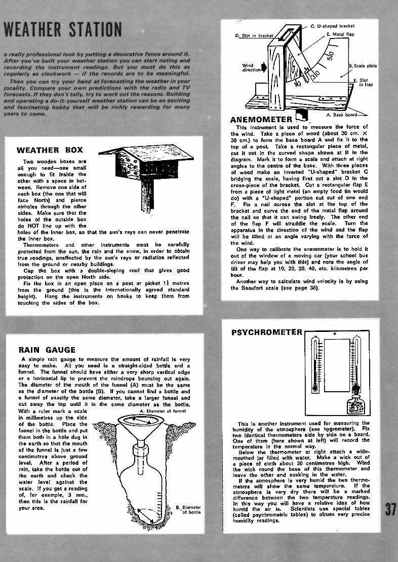
WEATHER STATION
a really professional look by putting a decorative fence around it.After you've built your weather station you can start noting andrecording the instrument readings. But you must do this asregularly as clockwork if the records are to be meaningful.
Then you can try your hand at forecasting the weather in yourlocality. Compare your own predictions with the radio and TVforecasts. If they don't tally, try to work out the reasons. Buildingand operating a do-it-yourself weather station can be an excitingand fascinating hobby that wilt be richly rewarding for manyyears to come.
WEATHER BOX
Two wooden boxes are
all you needone smallenough to fit inside theother with a space in bet¬ween. Remove one side of
each box (the one that will
face North) and pierceairholes through the othersides. Make sure that the
holes of the outside box
do NOT line up with the
holes of the inner box, so that the sun's rays can never penetratethe inner box.
Thermometers and other instruments must be carefully
protected from the sun, the rain and the snow, in order to obtaintrue readings, unaffected by the sun's rays or radiation reflectedfrom the ground or nearby buildings.
Cap the box with a double-sloping roof that gives goodprotection on the open North side.
Fix the box in an open place on a post or picket 1è metresfrom the ground (this is the internationally agreed standardheight). Hang the instruments on hooks to keep them fromtouching the sides of the box.
C. U-shaped bracket
E. Metal flap
B.Scale platel
f. Slotin flap
ANEMOMETERThis instrument is used to measure the force of
the wind. Take a piece of wood (about 30 cm. X30 cm.) to form the base board A and fix it to thetop of a post. Take a rectangular piece of metal,cut it out in the curved shape shown at B in thediagram. Mark it to form a scale and attach at rightangles to the centre of the base. With three piecesof wood make an inverted "U-shaped" bracket C
bridging the scale, having first cut a slot D in thecross-piece of the bracket. Cut a rectangular flap Efrom a piece of light metal (an empty food tin woulddo) with a "U-shaped" portion cut out of one endF. Fix a nail across the slot at the top of thebracket and curve the end of the metal flap around
the nail so that it can swing freely. The other endof the flap F will straddle the scale. Turn theapparatus in the direction of the wind and the flapwill be tilted at an angle varying with the force ofthe wind.
One way to calibrate the anemometer is to hold itout of the window of a moving car (your school busdriver may help you with this) and note the angle oftilt of the flap at 10, 20, 30, 40, etc. kilometres perhour.
Another way to calculate wind velocity is by usingthe Beaufort scale (see page 38).
PSYCHROMETER
A. Diameter of funnel
RAIN GAUGE
A simple rain gauge to measure the amount of rainfall is veryeasy to make. All you need is a straight-sided bottle and afunnel. The funnel should have either a very sharp vertical edgeor a horizontal lip to prevent the raindrops bouncing out again.The diameter of the mouth of the funnel (A) must be the sameas the diameter of the bottle (B). If you cannot find a bottle anda funnel of exactly the same diameter, take a larger funnel andcut away the top until it is the same diameter as the bottle.With a ruler mark a scale
in millimetres up the sideof the bottle. Place the
funnel in the bottle and putthem both In a hole dug inthe earth so that the mouth
of the funnel is just a few
centimetres above groundlevel. After a period ofrain, take the bottle out of
the earth and check the
water level against thescale. If you get a readingof, for example, 3 mm.,then this is the rainfall for
your area. vtV-fc Is B. Diameter.. iir» . CV|( -0j bottle
This is another instrument used for measuring thehumidity of the atmosphere (see hygrometer). Fixtwo identical thermometers side by side on a board.One of them (here shown at left) will record thetemperature in the normal way.
Below the thermometer at right attach a wide-mouthed jar filled with water. Make a wick out ofa piece of cloth about 20 centimetres high. Windthe wick round the base of this thermometer andleave the other end soaking in the water.
If the atmosphere is very humid the two thermo¬meters will show the same temperature. If theatmosphere is very dry there will be a markeddifference between the two temperature readings.In this way you will have a relative idea of howhumid the air is. Scientists use special tables(called psychrometric tables) to obtain very precisehumidity readings.
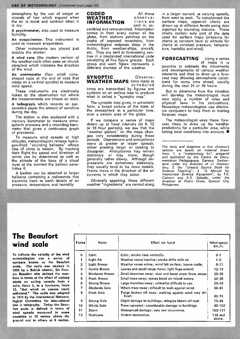
ETEOROLOG page 33)m m
atmosphere by the use of catgut orstrands of hair which expand whenthe air is moist and contract when it
is dry.
A Psychrometer, also used to measurehumidity.
An evaporimeter. This instrument isused to measure evaporation.
Other instruments are placed justoutside the shelter:
A wind vane (the modern version ofthe weather-cock often seen on church
steeples) which indicates the directionof the wind.
An anemometer (four small cone-shaped cups at the end of rods thatrotate on a vertical spindle) to measurewind speed.
These instruments are electricallylinked to the observation hut where
the measurements are shown on dials.
A heliograph, which records on sun-sensitive paper the amount of sunshineduring the day.
The station is also equipped with amercury barometer to measure atmo¬spheric pressure and a recording baro¬meter that gives a continuous graphof pressures.
To measure wind speeds at highaltitudes, meteorologists release hydro¬gen-filled "sounding balloons" whoserate of climb is known. By trackingtheir flight the speed and direction ofwinds can be determined as well as
the altitude of the base of a cloud
layer at the moment the balloon pene¬trates it.
A basket can be attached to largerballoons containing a radiosonde thattransmits back to earth details of air
pressure, temperature and humidity.
CODED All theseWEATHER observa-INFORMATION »ions are
sent in, as¬sembled and retransmitted. Information
comes in from every corner of theglobe, from stations perched on thepeaks of exposed mountains, frommeteorological outposts deep in theArctic, from weather-ships, aircraft,etc. They are sent to forecasting cen¬tres in a condensed international code
consisting of five figure groups. Eachgroup and each figure represents adifferent element of the weather.
SYNOPTIC Observa-
WEATHER MAPS tions made atse hed u I ed
times are transcribed by figures andsymbols on an outline map to producewhat is called a "synoptic map".
The synoptic map gives, in schematicform, a broad picture of the state ofthe atmosphere at a particular time,over a certain area of the globe.
If we compare a series of mapsdrawn up at fixed intervals (at 6, 12or 18 hour periods), we see that the"weather picture" on the maps chan¬ges very considerably during theseperiods. Depressions and anticyclonesmove at greater or lesser speeds,either growing larger or tending todisappear. Anticyclones may remainstationary or may move, thoughgenerally rather slowly. Although de¬pressions are sometimes stationary,they usually tend to be more mobile.Fronts move in the direction of the air
currents in which they occur.
Generally speaking, these differentweather "ingredients" are carried along
in a larger current, at varying speeds,from west to east. To complement thesurface maps, upper-air charts aredrawn up at different levels using datasupplied by sounding stations. Thesecharts contain only part of the dataused for surface maps (pressure forcharts at constant level or altitude for
charts at constant pressure, tempera¬ture, humidity and wind).
FORECASTING Using a seriesof maps it is
possible to estimate the movementsand developments of various weatherelements and thus to draw up a fore¬cast map showing atmospheric condi¬tions for some time ahead, usuallyduring the next 24 or 48 hours.
But to determine how the situation
will develop the meteorologist mustalso apply a number of rules andphysical laws in his calculations.Nowadays meteorologists use electro¬nic computers to help them in makingforecast maps.
The meteorologist uses these fore¬cast maps to draw up his weatherpredictions for a particular area, whiletaking local conditions into account.
The texts and diagrams in this children'ssection are based on material drawn
from: 1. a "meteorology kit", preparedand published by the Centre de Docu¬mentation Pédagogique, Geneva, Switzer¬land, under tfte direction of 1.1. Dessou-
lavy; 2. the "Unesco Source Book forScience Teaching"; 3. "A Manual forImprovised Science Equipment", by T.E.Calvero and E.S. Sábado, under thedirection of Pedro Orata, Quezon CityPhilippines.
The Beaufort
wind scale
To indicate the velocity of the windmeteorologists use a series ofnumbers known as the Beaufort
scale. The scale was devised in
1806 by a British admiral, Sir Fran¬cis Beaufort who defined the num¬
bers in terms of the effect of various
winds on sailing vessels from acalm, force 0, to a hurricane, force12, "that which no canvas couldwithstand." The scale was adopted
in 1874 by the International Meteoro¬logical Committee for internationaluse in telegraphy. Today the Beau¬fort scale is defined in terms of
wind speeds measured in somecountries at 10. metres above the
ground and in others at 6 metres.
Force Name Effect on Land Wind speedkm./h.
0 Calm Calm; smoke rises vertically. 0-1
1 Light Air Weather vanes inactive; smoke drifts with air. 1-5
2 Light Breeze Weather vanes active; wind felt on face; leaves rustle. 6-11
3 Gentle Breeze Leaves and small twigs move; light flags extend. 12-19
4 Moderate Breeze Small branches sway; dust and loose paper blow about. 20-28
5 Fresh Breeze Small trees sway; waves break on inland waters. 29-38
6 Strong Breeze Large branches sway; umbrellas difficult to use. 39-49
7 Moderate Gale Whole trees sway; difficult to walk against wind. 50-61
8 Fresh Gale Twigs broken off trees; walking against wind very dif¬ficult. 62-74
9 Strong Gale Slight damage to buildings; shingles blown off roof. 75-88
10 Whole Gale Trees uprooted; considerable damage to buildings. 89-102
11 Storm Widespread damage; very rare occurrence. 103-117
12 Hurricane Violent destruction. 118 and
above.

Like human fingerprints, no two snow crystals
are ever exactly alike. Although often similar in
general outline and structure, snow crystals come
in a bewildering variety of size, shape and pattern.
They often take the form of triangles, hexagons
or six-pointed stars. When the air is very moist
they may clump together to form snowflakes. One
snowf lake may consist of as many as 50 interlocking
crystals. Enthralled by their beauty, an American
farmer-meteorologist, Wilson A. Bentley, spent
hours each winter photographing snow crystals
near his home in Vermont. Nearly half the 5,000
photomicrographs he prepared appeared in the
book "Snow Crystals", first published in 1931 by
McGraw-Hill Books, New York; we reproduce18 of these illustrations below.
A SHORT
GUIDE
TO
WEATHER-SPEAKPhoto W.A. Bentley < taken from "Snow Crystals",by W.A. Bentley and W.J. Humphreys, Dover Pub¬lications Inc., New York.
by François Le Lionnais
and Roger Clausse
3TJ5
H?6» û7%
ai&
iText i) Copyright O.R.T.F.
Reproduction prohibited
jaiac
' '*&
»'*-#-
'v-.:'
E£
nfflri
FRANÇOIS LE LIONNAIS. Meteorologists uselots of technical words that are unknown to the
man-in-the-street. As a meteorologist, would youlike to give a few examples?
ROGER CLAUSSE Well, to take a few at random, I couldmention anticyclone, isobar, cyclogenesis, frontolysis, hydro-meteor or isohypse. Then there are everyday words witha special meaning, such as "waves" as in "polar frontalwaves" or the word "family" in the expression "family ofdisturbances", which means alternate zones of rain clouds,showers and brief intervals of fine weather. Another fami¬liar word with a special meaning is "front", in the sense ofa surface where masses of warm and cold air come into
"conflict" the same idea as front in the military sense.
F. L. L. The words you just mentioned front,conflict, masses of air aren't they connected withwhat we usually call bad weather? What causes badweather?
R- C. Bad weather is caused by differences of atmo¬spheric pressure in different parts of the world. Generallyspeaking, bad weather is linked with zones of low pressure,while zones of high pressure keep the bad weather out.
F. L. L. Perhaps you would explain what exactlyatmospheric pressure means?
R. C. Anyone who has looked at a barometer knowsthat atmospheric pressure, which corresponds to the weightof air pressing down on a given surface area, can vary
CONTINUED NEXT PAGE
39
40
TALKING ABOUT THE WEATHER (Continued)
from one reading to the next. Atmospheric pressure variesfrom one part of the world to another, but at any givenmoment pressure will be constant along imaginary lineswhich one can draw on the map.
For example, in Brazil pressure might be the same inBahia, Carinhanah, Brasilia and Araguari. The line joiningthese points is what we call an isobar, which simply meansa line of equal pressure. A different isobar with a differentvalue might, for instance, pass through other Brazilian citiessuch as llheus, Belo, Horizonte and Rio de Janeiro.
These isobars thus correspond to varying values ofatmospheric pressure at a given moment over a regionwhich can vary considerably in extent. Taken all togetherthey make up what is called the field of pressure. Theyare given in millibars, a unit signifying the amount of pres¬sure which will support, roughly, three-quarters of a milli¬metre of mercury in a barometer tube. So what is knownas standard pressure (1013.3 millibars) will support a columnof mercury 760 mm. high or, to give you a better idea, itrepresents 1,033 grammes of air pressing down on everysquare centimetre.
These isobars form curvy shapes. One might imagineone of them, say isobar 1,000, passing in the U.S.S.R.through Odessa, Berdichev, Gomel, Voronezh, Mizlerovoand back to Odessa, thus describing a rather irregularcircle. Inside this line, there may be other "contour lines",getting smaller and representing lower and lower pressures
975 - 970 - 965 millibars, etc. This is what we calla depression, in which the nearer the isobars are to thecentre the lower the pressures they represent.
In other zones the pressure increases towards the centre,and these are called anticyclones.
Broadly speaking:
a depression is a zone of low pressure and an anti¬cyclone is a zone of high pressure.
If we keep this idea in mind, it will help us to identifyzones of fine weather and bad weather.
F. L. L. From this idea of anticyclones anddepressions, can. we tell what the weather is goingto be like?
January in Kabul market-place, Afghanistan.
R. C. Certainly. The deeper a depression that is, thelower the pressure at the centre, the smaller its diameter,and the more rapidly it moves the more marked will bethe meteorological processes which go with it. In otherwords a small depression with a very low pressure at thecentre is likely to be accompanied by a storm. Once weunderstand this code, we can at once decipher any graphicrepresentation of the weather situation such as mapsshown in television weather forecasts.
Because of the effect of the Earth's rotation, windsmove in a clockwise direction around anticyclones andin the opposite direction around depressions in the northernhemisphere, and these directions are reversed in the south¬ern hemisphere.
The position of these elements on the map thus givesan immediate idea of the general movement of winds ina particular area. To the east of a large-scale anticyclone,in the northern hemisphere, for instance, the wind will becoming from the north and will therefore be cold, while tothe west it will be a warm south wind. It is easy to geta mental picture of all the possible combinations and allthe winds which would result from them and thus to have
some idea of the likely temperature.
F. L. L. You mentioned storms 'just now. Couldyou say a few words about the storms we callcyclones?
R. C. Yes, because there may be some confusion aboutthe word cyclone. The basic idea behind the wordcyclone is that of a circular, turning movement. We nowknow that this is what happens in the case of depressionsaround which the wind and in some cases rain move ina circle.
A depression is thus a cyclone in this sense, andmeteorologists use either word to mean the same thing.But most persons use the term cyclone when they meantropical cyclones, which originate in the warmer regionsof the world over the oceans. These disturbances arerelatively small a few hundred miles across and thepressure at their centre is very low 900 millibars, theequivalent of 675 mm. of mercury. They are accompaniedby very violent winds sometimes reaching more than

200 km./h. They have the typical circling movementcorresponding to the word cyclone.
F. L. L. Do cyclones move about from place toplace very rapidly?
R. C. No, fortunately they move relatively slowly, atabout 20 to 50 km./h., which means that it is possible todetect them and to forecast their arrival either by meansof radar or by pictures sent back by satellites, from whichthey are easily visible in the form of a ring of clouds.
F. L. L. By a ring of clouds, do you meanthat the sky is clear in the middle?
R. C. Yes, this is called the eye of the cyclone, wherethe sky is usually clear. Satellite photographs have shownthat even the cyclones in the temperate part of the world
depressions accompanied by clouds and rain often havea small eye in the middle, which goes to prove that theyare formed in the same way as tropical cyclones.
F. L. L. Just how and why do tropical cyclonesbegin?
R. C. Cyclones originate for the most part over theoceans in the tropics, where the temperature of the seaand of the layer of air in contact with it is very high inrelation to the upper levels of the air. This causes violentupward movements, drawing masses of very humid air upfrom sea level. These conditions often occur during thehot season in both hemispheres.
F. L. L. How long does a cyclone last?
R. C. Usually about a week. After that the depressioneither fills or spreads out, in either case becoming lessintense. We might in passing mention two other namesconnected with cyclones: typhoon, which is simply anothername for the cyclones occurring in the China Sea, and hurri¬cane, which is another synonym of tropical cyclones, usedin the English-speaking parts of the world.
F. L. L. What word from the language of themeteorologist shall we look at now?
R. C. Well, as a change from the more violent aspectsof the weather, let's talk about trade winds. Most peoplehave heard about them and associate them with the sea.
F. L. L. That's right, because in the days ofsailing ships, merchant ships depended greatly ontrade winds. And as a matter of fact they helpedthe ships of Christopher Columbus to sail fromEurope to America.
R. C. Some people say that Columbus discovered thesewinds. Incidentally the French word for the trade winds"alizés" is believed to come from an old French word
meaning "regular". The trade winds do in fact blow fairlyregularly in the intertropical zone, from the north-east inthe northern hemisphere and from the south-east in thesouthern. They are caused by the same sort of phenom¬enon as we have just been describing, that of air currentscirculating around the anticyclones which persist over thetropical regions of the oceans while low pressures prevailover the equator. They are not very strong from about15 to 30 km./h. and are usually accompanied by fineweather.
F. L. L. What happens between these two belts ofwinds, at the equator itself?
R. C This is where the equatorial calms occur, the"doldrums" which sailors in bygone days used to dread.English sailors also called these regions the "horselatitudes", apparently because when ships were becalmedfor days or even weeks on end, they had to throw theirhorses overboard when their supplies of water and hayran out.
F. L. L. While we are on the subject of wind,perhaps you could tell us about the various termsused by meteorologists and sailors for strong winds.
R. C. First of all there are the gusts of wind which occurduring a thunderstorm, and which, if they recur frequently,are characteristic of an unstable, turbulent state of the
atmosphere. Wind speeds in such gusts can vary widely
and rapidly and can reach over 20 m. per second in a fewseconds, which is dangerous for anything which is suscep¬tible to the wind, such as tents, cranes or sailing boats.
Gales, for which warnings to shipping are sometimesbroadcast, are winds with an average force of more than34 knots (62 km./h), which is equivalent to force 8 on theBeaufort scale, so called after the English admiral whoinvented it (see page 38). Gale force winds can whip upwaves over 5 m. high, which are very dangerous for sailingcraft. After the gale comes the "strong gale", a windwhich blows at between 75 and 88 km./h.
F. L. L. While on the subject of winds and the sea,could you tell us about breezes, which are morepopular with sailors than storms?
R- C. Breezes are local winds, usually not very strongand changing direction depending on the time of day.When the sun is shining over the coast, both the shore andthe sea are heated by the sun but the land gets hotter thanthe sea. Upward currents are formed over the land,drawing in the cooler sea air. An on-shore (towards theland) breeze is thus created this happens about threehours after sunrise and goes on until the sun sets. Sandyor rocky coasts absorb more heat than wooded coasts,so that the breezes will be more noticeable.
At night the land cools more quickly than the sea, with theresult that the movement of air is reversed and we have
an off-shore (towards the sea) breeze. This partly explainswhy the climate is mild at the seaside because it is warmedat night by the breezes coming from the land and cooledin the daytime by the sea breezes.
F. L. L. Does this also happen in other places?
R. C. Yes, in mountain regions where the cold air comesdown from the mountains at night, bringing lower tempera¬tures with it, while in the daytime the warmer air rises fromthe valleys towards the mountain peaks, sometimes causingthe sudden thunderstorms which are a menace to moun¬
taineers. Incidentally, the alternate heating and cooling ofland and sea which produce land and sea breezes arereproduced on a larger scale in the case of monsoons.
F. L. L. I always thought monsoons were sea¬sonal winds.
R. C. You're right. They are seasonal. In summer,the continents heat up more quickly than the oceans.Rising warm currents over the land create low pressureareas and cooler air over the oceans flows towards thecontinents. These air currents laden with moisture from
the oceans bring with them clouds and torrential rains.Passing over the steadily rising land to the mountains ofTibet, for instance, the rising air begins to condense andprecipitate its water vapour. In the winter the process isreversed and dry air pours seawards from the coldercontinental mass. "Monsoon" comes from the Arabic word
for "season", and was first applied to winds of the ArabianSea that blow six months from the south-west and sixmonths from the north-east.
F. L L. So monsoons occur in other places thanIndia.
R. C. Yes, monsoons are particularly intense in south¬east Asia, but they also exist, to varying degrees, in thewestern part of the Pacific Ocean, northern Australia, partsof Africa and even along the edge of the Gulf of Mexico.
F. L. L. Now, what about a word which interestsall of us sunshine.
R. C. Meteorologists use the word insolation, rather thansunshine, in other words, the amount of direct solar radia¬tion received. They also speak of "insolation duration",meaning the number of hours and minutes in a day, monthor year when the sun is visible from a given point.
Paris in July, for instance, gets on average 238 hoursof sunshine, Nice 363, Kazan 300, New Delhi about 200(since it is the monsoon season in India), Perth 250, Rioand Addis Ababa 200 each, and of course there is none at
all in the Antarctic, where it is the middle of the longwinter night.
CONTINUED NEXT PAGE
41
TALKING ABOUT THE WEATHER (Continued)
42
F. L. L. When the sun is more or less covered byhazy cloud, one sometimes sees rings round it. Suchoptical phenomena, which usually occur near the sunor the moon, are known as haloes and coronas, butpeople tend to confuse them. Would you tell usabout them?
R. C. Yes, we call them "photometeors", in other words,optical phenomena of the atmosphere as against "hydro-meteors", which are composed of solid or liquid waterparticles such as rain, snow or fog. The commonest ofthe photometeors are the halo, the corona and of coursethe rainbow, which we all know.
The halo forms a circle of bright light around the sunor moon. If you hold out your hand at arm's length withthe palm covering the sun, the circle should appear atthe end of your fingers. Sometimes there is anothercircle around the first and sometimes there are even brightspots on either side of the sun or moon so-called "pillars"or luminous tangent arcs.
These effects are caused by the refraction of the lightpassing through the ice crystals of which high cloudsare formed, when such clouds form a continuous "cloudveil" often a sign of bad weather.
F. L. L. So the popular belief that a wide ringaround the sun means rain really has some basis.
R. C. Yes, and the belief that a smaller circle means thatrain is not in the offing is also correct. This smaller ring,which is much less clear, is a corona. The corona hasmore colours than the halo, and is closer to the sun ormoon.
It is caused by the diffraction of light through the finewater droplets not ice crystals this time of the thinclouds covering the sun. The corona thus usually appearswhen there is what is called a "mackerel sky". It may bea sign of poor weather, with light rain, but this is not anabsolute certainty.
These ideas about the approach of bad weather, bringus to the term "atmospheric disturbance". A disturbanceis a kind of atmospheric "ailment", which corresponds tothe arrival of a depression and begins with a period of"incubation". The wind changes to south or south-west(to take a typical example in the temperate zones of thenorthern hemisphere).
Pressure falls, thin clouds appear and begin to accumulateuntil they have formed a fine, continuous veil of cirrostratuscloud which completely covers the sky the sort of cloudveil we were talking about a moment ago. The barometeris now at its lowest point, the wind has veered to the west,and now a hole appears in the cloud cover.
There may now be a clear interval, but before the fineweather returns, there will be more showers, with fineperiods becoming more and more frequent. The windwhich is now blowing more strongly, sometimes in gusts,has veered further to the north-west, the barometer rises
again and finally the sky clears.F. L. L. What about the question of fog andvisibility.
R. C. Fog is another phenomenon which we come acrossat the seaside. Sailors sometimes call anything thathampers visibility a sea mist, but the meteorologist usesthe terms more precisely. He uses the word fog in caseswhere visibility is less than one kilometre and mist whenvisibility is between one and two kilometres.
F. L. L. Is there an accurate way of measuring
visibility?
R. C. Yes, there are instruments called visibility meters,which use a light source at a set distance linked to a photo¬electric cell which makes it possible to measure the degreeof opacity of the air through which the light passes. Themajor airports have a very sophisticated system of this sorton their runways. Instruments in the control tower enablethe air traffic controllers to see at what distance the landing
lights on the runways will be visible to pilots.F. L. L. Talking about fog, which consists of minutewater droplets suspended in the air, brings us to thequestion of pollution, one of the major problems ofour time.
R. C. To see how the various pollutants which arepumped into the air collect in the lower levels, we needto go higher into the atmosphere.
We know that in the lower part of the atmosphere, whichis called the troposphere, temperature falls as we go up,at the rate of about 0.6° C. for every 100 metres or so,which means that at an altitude of 10 km., the temperaturewill be minus 60° C. So we can understand why aircraftare properly insulated!
But in the layers of air nearest to the ground, there aremany exceptions to this general rule. When thick fogcovers Paris, a thermometer at the bottom of the Eiffel
Tower may show 10° C, while another thermometer at thetop of the tower may register 15°. This often happens inwinter. When the night sky is clear and there is not muchwind, the ground loses much of Its heat by radiation. Theair nearest to it also cools, becoming heavier and remainingclose to the earth's surface, whereas the air above it, beinga poor conductor, keeps more or less the same temperature.It becomes warmer than the air near to the ground, or atleast warmer than it would be if temperature fell off withaltitude in the normal way.
Thus we have what is called an inversion of temperature.When it occurs, the air is very stable, since the upper layerforms a sort of lid which prevents smoke, dust and exhaustfumes from escaping. They thus stagnate at ground levelfor days on end, making the pollution worse and worse.
F. L. L. If inversions of temperature can be forecast,do special precautions need to be taken?
R. C. Yes, in heavily industrialized areas measures maybe taken to cut back production in industries which causepollution or where possible to use products which causeless pollution. Inversions of temperature can be detectedby means of radiosondes (balloons carrying instrumentsaloft whose recordings are transmitted by radio to groundstations). These devices enable us to find out the temper¬ature of the air at various levels up to a height of morethan 20 km.
F. L. L. What happens above the inversion layer?
R. C. The temperature again falls off with the altitude,unless there happens to be a second inversion layer. Thismay be caused by the arrival of warm air from a higherlevel, which might be the sign of an atmosphericdisturbance on the way. Higher still, about 10 km. up inthe temperate regions, about 7 km. at the poles and about17 km. at the equator, comes the stratosphere where thetemperature stops falling and starts rising.
F. L. L. What is the temperature at that level?
R. C. At the poles it is about -50° C, in the temperateregions about -56° C, and at the equator -85° C. Thismeans that an aircraft flying from the North or South Poletowards the equator at an altitude of 15 to 17 km. wouldhave to turn up its heating system, since the outsidetemperature would fall from -50° C. to -85° C. in the courseof the journey, in spite of the fact that at ground level thetemperature is getting higher all the time.
F. L. L. Why not go even higher and take a lookat the upper atmosphere which spacemen now traverseon their missions? You mentioned the troposphere,in which the temperature falls as one rises, butyou said that above that, in the stratosphere, thetemperature is at first stationary and then beginsto increase.
R. S. That's right, the temperature within this layer ofthe atmosphere, which extends from about 10 km. up toabout 50 km., rises from -56° C- to 0. This is due amongother things to the presence of ozone, which is concentratedabout 35 km. up. Contrary to what used to be thought,violent winds blow through the stratosphere, sometimesreaching well over 350 km./h.
Above the stratosphere, in the layer known as themésosphère, extending up for about a further 30 km., thetemperature falls off again rapidly, reaching 90D belowzero C. at its upper limit, a height of about 80 km.

Patterns in the sky
A sodium vapour cloud writes astrange message hundreds of milesup in the sky during a rocketexperiment designed to measurehigh-altitude winds and tempera¬tures. Here, French scientists studythe vapour experiment, launchedfrom NASA's Wallops Island Stationin Virginia.
Beyond that again, in the thermosphère which extendsto the outer limits of our atmosphere, 1,000 or so km. up,the temperature again rises, though it varies considerably.Beyond the level of 200 km., the speed of the highly rarefiedmolecules of gas corresponds to temperatures of severalhundreds of degrees but because the air is so rarefied, itsreal temperature in normal physical terms is extremelylow.
F. L. L. One word in the meteorologist's voca¬bulary which everybody knows and understandsis "forecasting". But some people feel that weatherforecasters tend to be overconfident in their pre¬dictions; that their forecasts are still a far fromsure guide to tomorrow's weather, unlike forecastsof the tides or the positions of the stars.
R. C. It's true that weather forecasts sometimes tell us:
"Cloud will develop tomorrow morning in the eastern partof the country" in much the same way as an astronomermight announce: "The annular eclipse of the sun will beginat 1 hr. 30.3 minutes Universal Time at 66°20 minutes East
and 20° North" and as far in advance as you like.
Yet there is clearly quite a different degree of accuracyin these two forecasts: one tends to be rather vague whilethe other has a mathematical precision. But I'm sure itwould be rather boring if forecasters were to tell us: "Allwe can say about the weather tomorrow is that cloud maydevelop in the morning west of a line drawn very roughlyfrom..., etc."
What is certain is that even with the most powerfulcomputers, meteorologists can only give the most likelyinterpretation, based on the information they have andusing approximate equations which enable them to simulatethe state of the atmosphere and the changes taking place
in it. I agree it would be better if they could indicate thedegree of probability of the prediction they have come upwith, but there are still problems to be solved in this area.
F. L. L. Before we end our visit to the world
¡of meteorology, would you please explain the myste¬rious terms which you mentioned at the beginningcyclogenesis, frontolysis and isohypse.
R. C. These terms are hardly ever used in weatherforecasts for the general public, but I can give you a briefdefinition: cyclogenesis, as its name suggests, is the pro¬cess by which a cyclonic circulation is formed; frontolysisis the process which causes a weather front to weaken ordisappear, in other words, the effects produced by theencounter of masses of air originating from different sour¬ces; and an isohypse is a surface, generally an isobaricsurface, within which pressure is constant. So as you see,the meanings of even these unfamiliar words are reallyquite simple.
FRANÇOIS LE LIONNAIS, French science consultant, mathemati¬cian and engineer, has been President of the French ScienceWriters' Association since 1950. He is well known to "Unesco
Courier" readers for his articles of science popularization.
ROGER CLAUSSE is a leading official of the French Meteoro¬logical Office and for many years headed its Information andPublic Relations Service. A member of the Council of the
French Science Writers' Association, he has written on meteo¬
rology for the press, radio and television and Is the authorof many popular science books on meteorology, including onefor children entitled "Papa dis-moi... Fera-t-il beau demain?"(Daddy, will it be sunny tomorrow?) published by Editions Ophrys,Paris, 1971.
43

This scene of death and desolation in Mauritania is being repeatedover thousands of kilometres in Africa south of the Sahara.
Drought and famine have stricken at least a dozen countries,
among the worst affected being Senegal, Mauritania, UpperVolta, Mali, Niger and Chad. Cattle are the livelihood of some70 per cent of the population of this area and the U.N. Foodand Agriculture Organization has estimated that the virtualextinction of many of the herds vital to villagers and nomad
herdsmen Is now a serious possibility.
DROUGHT
OVER AFRICA
1- tragedy strikes millionsof men and cattle
2- is the Sahara desert
moving South?
J --
by Jean Dresch
44JEAN DRESCH Is professor of geographyat the University of Pans and at France'sEcole Normale Supérieure. He is a leadingauthority on the world's arid zones, notablythose of North Africa and Africa south of
the Sahara, and has written extensively onthis subject.
T AMINE threatens millionsof villagers and herdsmen with theirdecimated flocks, today forced into anunprecedented migration in search offood and water, in all the West Africancountries to the south of the Sahara,from Mauritania to the Sudan.
Its cause is drought, a prolongeddecline in rainfall that has been
recorded as far as central Asia,
throughout the periphery of the aridzone, extending from the tropicaldesert of the Sahara to the continental
deserts of temperate Eurasia.
Drought, admittedly, is the normalcondition in these countries, and the
living world has adapted to it. In Africathese regions bear the Arabic nameof Sahel, which means the border,
whether of the desert or of the sea;
for they are not really part of thedesert proper.
The soil is less purely mineral than
the present-day soil of the Sahara andbears a generally open, scatteredvegetation in the form of "steppes" oftrees, bushes and annuals Gramina-ceae or of other families.
The vegetation grows denser andlusher in the lower latitudes and
becomes savanna, a closed formation
which feeds herbivores, and hence
carnivores, in increasing numbers butexposes them to burning in brush fires.
In these regions man is no longerobliged, as he is in the desert, to leadeither a nomadic life linked to the
dromedary or the secluded life of thewatered oases. He can raise cattle
and small livestock. He can till the soil
without irrigation.
For all that, these are the frontiers
of the desert. Man and the other
living creatures follow the rhythm oftwo main seasons, one the longeralmost completely dry, the other bothhumid and hot.

.
\*ft-
The Sahel feels the effect of cells
of tropical high pressure, which separ¬ate the low-pressure areas of theequatorial latitudes from those oftencharacteristic of medium' latitudes.
These high-pressure cells set veryregular, dry winds blowing towards thelow latitudes: these are the continental
trade winds, called in West Africa theHarmattan.
The rains follow the apparent motion
of the sun to the Tropic of Cancer
during the northern summer. Thusmasses of moist air advance coming
from the Atlantic Ocean or the Congo
Basin with southerly winds, which arediverted north-eastwards as they crossinto the northern hemisphere.
These air masses and winds, known
as monsoons, encounter the tropical
dry air and the trade winds (inter¬tropical convergence), plunge beneaththem and lift them. That is the time
when the rains fall; they are plentiful
and long-lasting in the south when themoist air mass is thick. Further north
they are less and less so. Disturban¬ces still occur but the hot-air tornadoes
of the late afternoon are increasinglyoften dry as the moist air mass thinsout and loses more of its moisture.
Under these conditions the precipi¬
tation decreases together with theduration of the wet season from 600 to
800 mm., where the wet season lasts
five to six months, down to 250 mm.,
where the season is only three months
long.
The shorter the rainy season, themore irregular it is in space, in timeover the year, and from one year toanother. The rains may start earlieror later, and may last a longer or ashorter time.
Furthermore, temperatures also risewith the apparent motion of the sun,
so that mean maximum temperatures
exceed 35 and 40 degrees C. in April
and May, except near the sea. Thecoming of the rains brings them downa little, but they are still high enoughto cause three times more évapotrans¬
piration (loss of water by evaporationfrom the soil and by transpiration fromplants) during the day than during thenight.
To be of practical value, therefore,
the rainfall must not only be generallyabundant, but also intense yet nottoo intense, about 20 to 25 mm. duringone or two days at the beginning ofthe rainy season.
The rains are not always spread tothe best advantage over the courseof a year, and each year is differentfrom the next. Sometimes a series
of good years occurs, only to befollowed by a bad year or a series ofbad years.
A sequence of dry years is remem¬bered in 1910-1914, when they causeda real famine. 1941 and 1942 were
CONTINUED NEXT PAGE
45

Horns of thousands of cattle killed by thirst in Senegal liewhitening under the African sun (below), while survivors (left)rummage in anything they can find. Since 1968 a vast beltof countries south of the Sahara has been hit by unremittingdrought. Last year and this year famine and death have reachedcrisis proportions. Some rainfall in Mauritania and elsewherein the summer of 1973 has brought slight relief. Right, in aChad village, two children gulp down a rare drink of water.Below right, a woman of Upper Volta shares her water rationwith her donkey.
'VT.
DROUGHT OVER AFRICA (Continued)
46
no better; and dry years have beensucceeding one another since 1968,whereas the decade 1951-1960 was
wetter. But there is no cyclical rhythmfrom which to predict disasters.
This year-to-year irregularity in rain¬fall is also characteristic of the Sahel
on a larger time-scale. More and moreis being learned about the detaileddevelopment of climatic conditions
over the Quaternary era. It appearsthat sweeping changes occurred, fromfairly wet periods to extremely dryperiods in which the Saharan winds
pushed the dunes 200 to 300 km.
further south than the living dunes oftoday.
On the other hand several wet
phases have been detected, the most
recent being put at 6,000 to 2,300 yearsago. The entire Sahara was better
watered during that time. There wereextensive lakes, and it is probable thatblack populations practised agriculturein the Sahel.
Cattle-rearing went on till much later,it was replaced by horse and thencamel-rearing. Even in the MiddleAges, however, the aridity was not sosevere. Many farming villages sur¬vived in the Mauritanian Adrar for
example. The rate of precipitation
must have been 400 to 450 mm, thestrict minimum for rain-watered tillageand double the present rate.
It is thought likely that the subse¬quent drying-out process has speededup since the end of the last century.It is said that rainfall is diminishing,wells are running dry, rivers are flood¬ing less often and in less volume,
dunes are being revitalized, vegetationis deteriorating and game animals arescarcer.
Does this mean that the climate
itself is becoming drier? Fluctuationsare a matter of historical record; theyare as yet unexplained, but they arenot always in the same direction.
Over the decade 1950-1960 there was
enough rain to speed up the northwardmovement of the cattle-herders, thePeul, and of the millet-growers. Theherdsmen come looking for grazing,and contend for it with the Saharans
who have to leave the desert in the
dry season.
The millet-growers colonize theSahel, like a pioneer fringe, in searchof new lands, whether they are blackpeasants or former Saharans, often theservants of nomadic tribes in processof settling.
The natural conditions in the Sahel,
then, are known, and man, with. his
age-old techniques, has managed toadapt his economy and his migratorymovements to them.
Today it should be possible to putbetter scientific knowledge of theSahel and modern techniques to use,not only in relieving the victims ofdrought but in bringing drought itselfunder control. However, it must be
recognized that the Sahels are verymarginal regions for the internationaleconomy.
Development activities have been
focused on regions further south,which were better watered and which
could grow crops at a profit for foreignmarkets. As a rule these are non-food
crops such as groundnut and cotton;it is known that they have not enrichedthe countries where they are grown,much less the peasants who growthem. They have helped to degradethe vegetation and hence to worsenthe threat of drought.
Population growth has forced theSahelian peoples to increase theirherds and to bring more land undercultivation. In dry-year periods, over¬
grazing and renewed ground-clearingactivity are carried to danger point.But people must live.

HORNS
OF UNPLENTY
Photo Marie-Laure de Decker © Gamma. Paris
However, there has never been
enough investment in these marginalregions. Wells have been dug, butnot enough of them, and they requireupkeep. Grazing land can be devel¬oped, controlled and improved; butlittle of this has been tried. Better use
can be made of water resources,
aquifers and, even more, rivers; buttheir development often stops short atthe planning stage.
In this ebbing century, forecastingis feasible. Through scientific studiesof natural and human conditions,solutions can be found. But that
entails applying the will and the necess¬ary means, before disaster strikes.
This article first appeared in the May 1973Issue of "Development Forum", a newmonthly newspaper published by the UnitedNations Centre for Economic and Social
Information (C.E.S.I.). "Development Forum"deals with the action of the United Nations
in the economic and social fields, and notablywith the major problems of the developingcountries, wasteful spending on arms, theinequitable distribution of resources, thepopulation explosion and the deterioration ofthe environment. For a complimentarysubscription, write to: C.E.S.I., P3/16, RoomC 525, Palais des Nations, 1211, Geneva,Switzerland.

Like some horrific, mythical monster rising from
the sea, this infra-red photograph shows atmo¬
spheric pertubations over a huge area of the Atlan¬
tic. The photo was taken from a height of 800 kilo¬
metres by the weather satellite Nimbus II. Study of
the general circulation of the atmosphere under the
Global Atmospheric Research Programme of the
World Meteorological Organization promises to
result in much more reliable long-range weather
forecasting.
LONG-RANGE
FORECASTING
OF DROUGHT
AND FLOODSIs there any chance thatpresent forecasts can
be extended beyond a month?
48
by Jerome Namias
JEROME NAMIAS, Research Meteorologistat Scripps Institution of Oceanography, Lalolla, California, is one of America's leadingweather scientists. He has received manyawards for his research in meteorology, andhe is widely known for the system he devel¬oped of up-to-one-month weather forecasting.
IN this era of rapid commu¬
nication everyone is quickly informedabout meteorological disasters suchas floods, droughts, tropical cyclonesand tornadoes. Some disasters, suchas cyclones and tornadoes, are pre¬dictable over a time span of a dayor so, so that precautions can savelife and property.
Other natural phenomena are moreinsidious. Drought, for example, de¬velops over months, seasons, andsometimes years and causes evengreater human suffering through fam¬ine and economic dislocations. Are
these insidious long-term disasterspredictable? If not, what is the hopethat they ever will be?
We are all aware of the ravages ofnatural events of the recent past thedevastating Russian drought of 1972;current drought in sub-Saharan coun¬tries, especially Mali, Mauritania andthe Upper Volta, which seems to havepersisted and become aggravated inthe last few years; the occasionalseasonal droughts in parts of Indiaand Australia and the "Seca" or"
drought which occurs in some yearsin northeast Brazil.
On the wet side, we have theeastern U.S.A. floods in June, 1972,associated, in part, with hurricaneAgnes the most costly storm in U.S.history, and we remember the 1966tragic flood of Florence. These are

but a sample of spectacular eventsfrom the climatological record.
From time immemorial there have
been occasions when nature "goes ona rampage" and makes it appear thatthe climate is changing. Why doesnature do this? Unfortunately mandoes not yet fully understand thecauses of these events, and thereforehe is unable to predict them reliably.
Yet meteorologists and climatolo-gists have made great strides in study¬ing them over the past few decades.The World Weather Watch (WWW)programme of the World Meteorologi¬cal Organization (WMO) and comple¬mentary (WMO - International Councilof Scientific Unions) Global Atmos¬pheric Research Programme (GARP)promises to bring much greater under¬standing and perhaps reliable long-range weather prediction (see articlespages 4 and 21).
At present scientifically-based long-range predictions are limited to amonth or, at most, to a season inadvance. These are general in natureand mainly attempt to predict whetherprecipitation over broad areas will beabove, below or near the long periodaverage (normal) and whether theseareas will have subnormal, normal or
above normal temperatures.The methods used are, for the most
part, not precise enough to indicate
the beginning or ending of greatdroughts, which span more than oneseason and may last for years. Nei¬ther are the methods precise enoughto forecast the record-breaking per¬sistent rains which lead to floods.
Let us examine some of the known
factors associated with drought, forthis may give some idea of the com¬plexity of long-term atmospheric be¬haviour. The immediate cause of
drought is sinking motions of air mas¬ses. These descending air motions, ofthe order of a few hundred metres a
day, result in compressional warmingof the air since it is subjected toincreasing pressure in descent. This isanalogous to the heating of a bicyclepump in use.
While the absolute quantity ofwater vapour in an air parcel remainsunchanged in descent, the relativehumidity decreases because the capa¬city for holding moisture has beenincreased in the warmed air. In thismanner cloud formation is inhibited
or if clouds are formed, they are soondissipated.
The areas over which such sinkingair motion (called subsidence) prevailsmay involve 5,000,000 square kilo¬metres or an area as great as westernEurope. With ascent of air, coolingleads to increase in relative humidity,cloud and eventually precipitation.
The atmospheric circulations which
lead to this subsidence or ascent (the"centres of action"), are linked tohorizontal wave patterns in the westto east flow that prevails in temperatelatitudes. These wave patterns areclearest at levéis between 3 and 15
km. above the earth.
Thus the westerly winds aloft areusualJy contorted in the form of pole¬ward or equatorward bulges (ridgesor troughs, respectively) great me¬anders resembling the sine waves oftrigonometry. There may be five or sixsuch waves in a hemisphere at onetime. The sinking motion takes placemainly in the ridges and the airascends in the troughs.
These planetary features can beobserved, of course, on any one day'sweather map, but they, also appeareven when maps are averaged overa month, a season, and even a yearor period of years. The reason isthat a series of persistently recurrentatmospheric systems, often of an ab¬normal type, can dominate a specificarea. If these systems are ridges,then the stage is set for persistentsubsidence of air masses, drynessand drought; if troughs persist, thestage is set for ascent of air, cloudand rain.
The placement of these statisticallyaveraged troughs and ridges is notchaotic; they are frequently arranged
CONTINUED NEXT PAGE
49

Mysteryair currents
of the
upper
atmosphere
Photo <D Vincent Schaefer, New York
In the upper reaches of the troposphere,
several miles above sea level, narrow
currents of fast-moving air flow in irregular,
meandering paths in an easterly direction
around the globe. The presence of these
currents was suspected early in this cen¬
tury, but it was the advent of high-flyingaircraft in the 1940s that confirmed the
existence of "jet streams" as these currents
are called. The strongest of these streams
occur in the middle latitudes. Over the
southern hemisphere they almost alwaysblow from dde west In the northern hemi¬
sphere the disturbing influence of the conti¬nents causes some deviation and at times
they blow from west south-west over the
Atlantic and Pacific oceans and from the
west north-west over the continents of
North America, Europe and Asia. Above,
diagram of a jet stream encircling the nor¬
thern hemisphere. A jet stream generally
reaches its maximum speed at heights of
LONG-RANGE FORECASTING (Continued)
50
in patterns suggestive of a vast tele-connective mechanism. In other
words, the position of one prevailingridge in the westerlies usually impliestroughs on either side and frequentlyother ridges beyond these troughs.
This interrelationship is reasonablywell understood by meteorologistsboth through theory and through em¬piricism. But what factors cause one
or mere of the ridges or troughs? Asolution to this question would be amajor advance.
The present quest for reliable long-range forecasting seems to narrowdown to two major possibilities, bothexternal to the atmosphere:
The abnormal waves in the west¬
erlies are in some unknown way gener¬ated and maintained by extraterrestrialevents such as variations in solar
activity;
They are generated and main¬tained by variations in the characterof the underlying earth's surface.
The latter possibility refers to chang¬es in the amount of snow and ice,mainly on the continents, and also tothe variable temperatures of the sur¬face layers of the oceans. Both ofthese surface features change muchmore slowly than the restless over¬lying atmosphere and thereby mightprovide a "memory" so that persis¬tently anomalous wind and weatherpatterns are periodically restored.
Today's meteorologists are more aptto espouse the second rather thanthe first (extraterrestrial) hypothesis.Many feel that we must first study,as completely as possible, the terres¬trial air-sea-land system before intro¬ducing abnormal solar influences.
Of course, there exists another pos
sibility, which hopefully is not a prob¬ability namely that the planetaryatmospheric wind systems are at thewhim of very small and immeasurableforces so that chance alone deter¬
mines what form the atmosphere willassume in the next month or next
season. Fortunately, meteorologistshave reason to believe that nature is
not playing dice with them.
In addition to the waves in the
upper westerlies, there are variationsin the latitudinal positions of these airstreams. Thus in some winters the
central core of the westerlies may be10° to 15° of latitude farther south
than in others, so that storms prevailin the sub-tropics while higher lati¬tudes remain relatively storm free.
Such variations appear to be asso¬ciated with big weather variations inthe tropics and even with hemispheric

9,000 to 12,000 metres- It usually blows
at about 190 km/h., but may attain speeds
of up to 500 km/h. Several distinctcurrents of wind flow at differing speeds
along the axis of a jet stream with the
higher speeds occurring at the core of thestream (see diagram right). The difference
in wind speeds along the axis of a jet
stream may be as much as 160 km/h. ormore. Occasionally a jet stream divides
into two main belts of very strong winds
a considerable distance apart. Jet streams
are of very great importance to aviation.Modern aircraft often make use of these
powerful air currents. By "hitching-a lift"in a jet stream an airliner can cut a long¬
distance flight time by nearly half with a
great saving in fuel. In weather forecast¬
ing jet streams are important becausecertain types of storm occur most often
just beneath them. Left, high-flying cirrus
clouds being swept along in a jet stream.
a, i 7 / v -^-s*>!' --: -z
Fe
*G**J&SÍK
inter-actions between northern and
southern hemispheres. One of theideas to emerge during the past fewyears is that the tropical atmosphereis forced into abnormal behaviour byvariations in the underlying oceantemperatures along the equator, andthat these variations, by complextransports, mould the patterns of thewesterlies in mid-latitudes.
There is also some evidence to indi¬
cate that the tropical systems, includ¬ing the ocean temperatures along theequator, are frequently forced byevents in the middle and sub-tropicallatitudes. Most probably there areinteractions and "feedbacks" both
ways.
Thus the question of which comesfirst, like the "chicken or the egg",may not get a satisfactory answer.But this need not stop progress in
long-range forecasting a subject re¬plete with complexly coupled systemsof many kinds.
To return to some of the anomalous
weather events cited at the beginningof the article, we find some evidence
for the following connexions: The Rus¬sian drought of '1972 was associatedwith a persistent and strong ridge aloftin both summer and the antecedent
winter a ridge which may have beeninitially engendered by a strong troughaffecting the British Isles, a strong ridgein mid-Atlantic, and by anomalous seasurface temperature patterns over theNorth Atlantic (cold in the north, warmin the south).
The sub-Saharan drought seems tohave been associated with a failure of
the intertropical convergence zone (thetropical mechanism for lifting largequantities of air) to move northward
in the rainy seasons this failure mayhave been due to wind systems in tem¬perate latitudes or elsewhere.
The Eastern U.S.A. floods associated
with hurricane Agnes, and perhaps thewet soil left from preceding storms,appears to have occurred in a vul¬nerable trough area separating tworidges the strongest of which lay inmid-Atlantic.
This ridge was probably related tothe one immediately responsible for theRussian summer drought.
The above conclusions are by nomeans borne out by physical calcula¬tions, but a world-wide effort by GARPand WWW may result in development
of mathematical-physical models using r\billions of observations and high-speed Jl Icomputers to unravel the secrets ofwhat is probably the world's secondmost difficult problem.

by Peter Rogers
WHAT CAN
WE DO ABOUT
TROPICAL
CYCLONES ?
The answer is 'quite a lot'.
An early-warning system
now exists, but...
N
52
I OT without justification thetropical cyclone has been describedas the greatest storm on earth.Spawned over the warm waters of
the tropical oceans, cyclones have,throughout the ages, taken a terribletoll of human lives and created miseryand damage of unknown extent. Inthe long catalogue of meteorologicaldisasters from which mankind suffers
they have been responsible for 80 percent of all the lives lost.
What is a tropical cyclone? Itmay be broadly described as a largevortex of air spiralling inward towardsthe centre where the pressure is ata minimum. This area, known as the
eye of the storm, contains only lightwinds or may even be calm.
Around the eye explosive cloud
growth takes place as warm, moisttropical air escapes upwards reachingperhaps, above 12.000 metres. Thisis the region of maximum windswhich in a mature storm may exceed270 km. per hour.
The effects of the cyclone may befelt over as much as 500 km. from the
eye, diminishing progressively in vio¬lence away from the centre.
The meteorologist classifies them
according to their intensity, calling
PETER ROGERS is a specialist on tropicalcyclones at the World Meteorological Organ¬ization. He has been c/ose/y associated withthe World Weather Watch and with WMO
projects to reduce damage and loss of lifecaused by cyclones, in particular the pro¬gramme of the typhoon committee of south¬east Asian countries set up In 1968.
them tropical depressions with windsup to 60 km. per hour, tropical stormswith winds up to 115 km. per hour
and hurricanes' at higher sustainedwind speeds. Considerable areas are
affected by violent winds and protract¬ed heavy rains, causing extensiveflooding and damage.
For the layman there is often confus¬ion between tropical cyolones, hurri¬canes and typhoons. In fact all arethe same phenomenon; in the Carib¬bean they are known as hurricanesand in the north-west Pacific they aretermed typhoons. Tropical cyclonesalso occur in the south-west Indian
Ocean, in the Bay of Bengal and theArabian Sea, and in parts of theSouth Pacific, as well as around thenorthern coasts of Australia.
History records many examples ofsevere tropical cyclones causingenormous loss of life and destruction.
We need not look back far because
what may have been the worst cyc¬lone ever struck what is now Bangla¬desh on the night of 12-13 November1970.
The accompanying storm surge,caused by low barometric pressureand hurricane force winds, was fun¬
nelled into the head of the Bay ofBengal by the converging coastlineand shallow waters. Its landfall almost
coincided with flood tide. The heightof the surge varied from 3 to 9 m. andwhen it had swept over the offshoreislands and low-lying coastal belt300,000 people lay dead.
Catastrophes of this magnitude in¬variably arouse man's indignation. Hefeels strongly that nature must betamed and not permitted to wreak itshavoc unchecked. Man has alwaysresisted the intemperate moods ofnature, too often vainly. Can we doanything about tropical cyclones?The answer to this question is anemphatic "Yes".
Even though we may be far fromdiscovering how to tame their fury,sensible precautions together with aneffective warning system save manylives and limit damage. In fact it hasbeen estimated that at least 80 percent of the lives lost can be saved.
While the cost of damage showsa steady upward trend in almost allcountries, much can still be done to
keep it to a minimum. For example,a building code that increases thecost of construction by only 6 percent can reduce damage by 60 percent for sustained winds up to 240 km.
per hour. It is not considered econo¬mically feasible to build to protectproperty against winds over 270 km.per hour.
To achieve this calls for a sophisti¬
cated warning system and the closestco-operation between all those withresponsibilities for community prep¬aredness and disaster prevention, aswell as relief and rehabilitation. The
first step is, naturally, the detection,tracking and forecasting of where thecyclone will strike, and of its expected
CONTINUED PAGE 56

BANGLADESH
most
devastating
cycloneof this
century
The tropical cyclone whichravaged Bangladesh in Nov¬ember 1970 was one of the
most devastating of this cen¬tury. Here an elderly manfrom Bangladesh weeps forthe loss of family and friendsswept away in the disaster.
CONTINUED NEXT PAGE

p¿r3£>«*$BANGLADESH (Continued from page 53)
Life-saving ' Killas '
Nearly half a million people lost their lives in the cyclone thatstruck Bangladesh on the night of November 12/13, 1970. Manyof these lives could have been saved if communications hadbeen better and if the chain of artificial mounds known as "killas"
(opposite bottom) where men and cattle can take refuge in timeof flood, now being constructed with the help of the Red Cross,had been in existence. Evidence of the formation of a cycloneover the Bay of Bengal, moving rapidly north north-east, wasprovided by photos such as the one above received from satellite-
ITOS 1 at 0957 hours on November 10, 1970. By then it wasapparently too late to alert the inhabitants of the scatteredvillages of the low-lying, coastal regions of Bengal in time forthem to flee the huge tidal wave bearing down on them in thepath of the cyclone. With nowhere to run to (above) most ofthe victims died of drowning. Material damage (below) wasimmense, leaving the survivors deprived of their livelihood andentirely dependent for many months on supplies flown in in a vastinternational rescue operation (opposite top).
Photo Marilyn Silverstone © Magnum, Paris
ft I
I
54
ftA i.


TROPICAL CYCLONES (Continued from page 52)
... much remains to be done to save lives
and reduce damage from typhoons
effects in terms of wind strength, rain¬fall and flooding.
Earth-orbiting satellites, and moreespecially geostationary satellites,have largely relieved the meteorologistof the difficult problem of detectingthe formation of a cyclone over dist¬ant ocean waters from which he has
little other information. Precise posi¬
tioning of the cyclone centre some¬times remains difficult but steadily
advancing technology should resolvethis problem.
Cyclone tracks are notoriouslyerratic. In a 24-hour forecast, an
error of only 10° in predicting thetrack results in the cyclone strikingthe coast more than 185 km. from the
expected spot. Surveillance by satel¬lite, by specially-equipped reconnais¬sance aircraft and finally by 10 cm.storm warning radar when the cycloneis within 300-400 km. can ensure that
its path into the coast is closely moni¬tored. Thus, a meteorological systemmaking. full use of modern technolo¬gical aids is a prerequisite for theaccurate forecasting of cyclone move¬ment and development and the issueof accurate warnings.
B
56
UT the best forecast is
useless if nothing is done to act uponit. There must be carefully preparedand detailed national plans so that allthose responsible for the safety ofhuman lives and property know exactly
what to do when a warning is received.Above all, it is vital that the warningsreach everyone threatened by thecyclone in good time; people mustalso know how to protect themselves
and their property and fully understandwhat the risks are.
A vigorous campaign of public edu¬cation is the only means of achievingthis and must be repeated before eachtropical cyclone season if the lessonslearned are not to be forgotten.There must be the closest co-opera¬tion between the technical agenciesand those in the social welfare field
if the total system is to work effi¬ciently.
The population cannot be success¬fully protected from the 'onslaught ofa tropical cyclone if responsibilitiesfor different parts of the system arebroken down into separate, unco¬
ordinated parts.
Ultimately, the success or failure ofthe warning system depends upon
its weakest link man himself. An
accurate forecast, a well-designed dis¬aster prevention system, and all theaids that technology provides countfor little if the human response is notgeared to the realities of the occasion.
Every cyclone brings forth a crop ofstories demonstrating the endless div¬ersity of human reaction to the disas¬ter threat. Age, health, education,family situation, previous disasterexperience and many other factorsplay a role, but a role so complex thatno clear-cut pattern of behaviouremerges for general application tofuture disaster situations. The aero¬
space engineer in Texas can be asobstinate as the Bengali farmer inrefusing to leave his home whenadvised to do so.
Few authorities have the power tocompel evacuation of danger areas.And yet the pressures of increasingpopulation force people into low-lyingagricultural or coastal areas prone tostorm-surges. The potential for lossof human lives is growing in manycyclone areas and can only be re¬versed by the remorseless applicationof strict development controls. Verylittle has so far been done in this
respect and even the planning ofsatisfactory escape routes for evacua¬tion is frequently neglected.
In some regions such as Bangla¬desh, evacuation from low-lyingislands may not be feasible. There,under a project sponsored by theLeague of Red Cross Societies, "killas"
earthen mounds about 7 m. highhave been constructed to providerefuge for the local population. Suchrelatively simple measures can drastic¬ally reduce the loss of life fromtropical cyclones, 90 per cent of whichis caused by drowning.
In spite of their violence, hurricane-
force winds account for relatively fewdeaths. Flying objects propelled atgreat speeds constitute the primemenace but are easily avoided bytaking cover within a sound structureuntil the danger is past.
The eye of the storm, with its lightwinds, must not be taken as an indi¬
cation that danger is over. After ashort pause, the wind will blow with
renewed violence from the oppositequarter. Here, the need for careful
education of the public is again evid¬ent.
How are these measures being car¬ried out in the 40-odd nations of the
world afflicted by tropical cyclones?
Obviously the problems have beenthe same for many centuries but it isonly in recent times that man has rea¬lized how much he can do to reduce
casualties and prevent the seriousinroads of cyclone damage into thenational economy.
In most countries a warning system
has grown up to face this age-oldmenace but in many lands it is insuffi¬ciently well-developed to be com¬pletely effective. The World Meteoro¬logical Organization began to take aspecial interest in helping these coun¬tries in 1966, in close co-operationwith the U.N. Economic Commission
for Asia and the Far East (ECAFE).
HE urgent need to reducethe economic impact of typhoonsamongst the developing countries ofsouth-east Asia led to the setting upof the Intergovernmental TyphoonCommittee in 1968. Seven countries
and territories (1) formed this Com¬mittee with the avowed purpose of
conducting a joint programme toaccelerate action to reduce the loss of
life and damage caused by typhoons.
The programme encompasses meteo¬rological and hydrological facilitiesin the member countries to improvethe forecasting and warnings of ty¬phoons, training and research, andcommunity preparedness and disasterprevention to ensure that the publicare ready to meet the risks broughteach year by typhoons.
Five years have elapsed since this
programme began, bringing substan¬tial improvements to the TyphoonCommittee countries. New technolo¬
gical aids, such as satellite read-outequipment (APT), radar, telemeteringrain and stream-gauging equipment,help in the fight to improve the pre¬diction of typhoons and life-claimingfloods. Speedier telecommunicationspermit the flow of vital data to allinterested countries, and the trainingof national staff in the latest techniquesfosters increased awareness of the
ways in which science can help todefeat the typhoon bogy.
In March this year, with the help ofthe League of Red Cross Societies,WMO and ECAFE sent a three-man
team to Hong Kong, Korea and Thai¬
land. Its object was to promote closerco-operation between the various na¬
tional agencies active in pre-disaster
(1) Hong-Kong, Japan, Khmer Rep., Rep. ofKorea, Laos, Philippines, Thailand.

planning and to prepare a programmeof further action. This enterprise wasthe first of its kind and should do
much to stimulate a more co-ordinated
approach to disaster prevention.
These pioneering activities of theTyphoon Committee soon evokedgrowing attention in other tropicalareas. One direct consequence hasbeen the setting up of two other re¬gional groups with closely similarobjectives one for the Bay of Bengaland the Arabian Sea, and the otherfor the south-west Indian Ocean.
Although they are only now beginningtheir task, there are good grounds
for hoping that the regional appjpachapplied in the typhoon area will beequally efficacious in these otherareas.
The tragic Bay of Bengal cycloneof 1970 became the starting point fora further focussing of WMO's effortson the cyclone problem. When soonafterwards a series of typhoons rav¬
aged the Philippines causing furtherheavy loss of life and massive dam¬age, the Typhoon Committee appealedto the United Nations General Assem¬
bly for international action. TheGeneral Assembly reacted promptlyto this appeal, calling upon WMO tomobilize scientists and resources to
discover ways of mitigating the harm¬ful effects of these storms and of
removing or minimizing their destruct¬ive potential.
WMO responded by setting up itsTropical Cyclone Project. It thenassembled a group of internationalexperts in tropical cyclones to reviewthe state of forecasting, warning andother needs for damage reduction, andto define the objectives of the Project.It next drew up a plan of action forthis long-term project. The plancovers the detection and forecastingof tropical cyclones, storm-surge andflood forecasting, warning systems,risk evaluation and disaster preven¬tion and community preparedness, aswell as disaster relief, training andresearch, and the development ofinstruments and equipment.
If the best methods and techniquesavailable in the world are to be used
by all countries in their struggle toreduce the impact of tropical cyclones,a great many studies and much devel¬opment work must be carried out. Itis an ambitious scheme in which the
topmost scientific talent in this fieldmust be given the resources to doa job of profound humanitarian impor¬tance.
Research into tropical cyclones hasbeen carried out in many countriesover a long period of years. Muchprogress has been made but there isa pressing need to harness the talentsof scientists in different lands for an
all-out attack on outstanding problems.
Only by the co-ordinated efforts ofmany workers can these problems befinally solved. One of the objectivesof the WMO Tropical Cyclone Projectis to foster this international effort
and to see that it is mainly directedto saving human lives and improvingthe quality of life by damage reduction.
It would be idle to deny that no
instant breakthrough can be expected.The horrors caused by tropical cyc¬lones have plagued mankind for cen¬turies and it would be unrealistic to
think that they can be effaced over¬night. We must plan for a long-termprogramme, measured perhaps indecades.
Whilst this essential work is goingon, it may confidently be expectedthat steady progress in applying mod¬ern technology to improving warningsystems through the various regionalprogrammes sponsored by WMO willcontinue and will effectively benefitmany countries. M
STURMSIGNAL
Japan, the Philippines and other parts of East Asia are periodicallyswept by typhoons and other natural disasters that take a heavy tollof life and property. Effective warning systems are being set up indifferent areas to meet the danger. Here, a storm signal is posted ina street in Zamboanga on the island of Mindanao (Philippines). In thiswarning system one siren blast means 50 to 90 km/h winds; two blastssignifies 90 to 120 km/h winds.
57

WEATHER LORE
WN THE AGESIII
A meteorologist discusses
facts and fancies of traditional
weather-wise sayings
by Roger Clausse
58
HE time may come whentomorrow's weather will be announced
with sure-fire certainly because by thenMan will make his own weather,
causing clouds and rain to appear anddisappear as he pleases.
Strangely enough this is how thepeoples of ancient times approachedthe problems of meteorology, althoughit was then believed that weather was
controlled by the gods who had onlyto be invoked in order to change thecourse of a storm or end a drought.
Such practices existed in all bygonecivilizations, from the shamans of the
Arctic who were reputed to control thecold and the ancient peoples of Black
Africa with their tom-toms for callingdown the rain, to the rain-making sacri¬fices shown in 3,000-year old picturesdiscovered at Sumer in Asia.
Similar methods and beliefs also
existed in ancient China and Japan,among the North American Indians andthe Aryans in India, the Greeks andRomans, in short in all the countries
now represented in organizations andauthorities concerned with world
meteorology.
But in terms of ideas and research
ROGER CLAUSSE fsee biographical note onpage 43).
on the study of the weather, a worldof difference exists between these
ancient and outmoded practices and
the still tentative attempts being madein our own time to influence the
weather.
Men learned first to observe pheno¬mena in order to understand them.
Then, noting coincidences or instanceswhen the same phenomena were re¬
peated, they learned to distinguish thelaws, or rather regularities, linkingthese phenomena together.
The first things that men observedwere naturally those around them, andhence their observations and their
deductions were based on the behavi¬
our of plants and animals.The weight which these deductions
carried and the wide credence which
they gained depended on the relation¬ship between the village headmen orelders who made them and their au¬
diences. The authority of the elders(in days when they were listened to andrespected) gave their sayings the cha¬racter of infallible pronouncements. Itis thus no wonder that, transmitted from
generation to generation with varyingdegrees of distortion, these old sawsof weather wisdom have survived for
centuries.
At all events, we can take a look at
some of the ancient sayings, that cer¬tain persons still accept without ques¬
tion, and try to distinguish betweenwhat is clearly true or false in them,
though we cannot hope to explain cer¬tain "mysteries" of the animal world.
Old almanacs going back nearly fivehundred years and manuscripts much
older still give impressive lists ofvarious symptoms of animal behavi¬our presaging rain or the return of fineweather.
It is quite true that animals, beingcloser to nature than man and, unlike
man, not taking medicaments of allkinds, have preserved a number of pri¬mitive responses to natural phenomenaand to the various ways in which theyimpinge on the living world.
Just as some species possessinstincts, probably based on sensorialperceptions unknown to us, which
enable them to find their way backover great distances to their seasonalhaunts or to detect the approach ofan enemy from far away, it is quitelikely that some animals are sensitive
to variations in atmospheric conditionsheralding changes in the weather. Aswe shall see, men can also forecast
these changes by looking out for cer¬tain clues.
Let us take a few examples of be¬haviour in animals and even in plantswhich are supposedly significant in re¬lation to the weather. Right away, andat the risk of seeming ignorant, wehave to admit we are not sure what to
make of the various sayings, often con¬tradictory or perhaps too subtleabout the abilities of frogs and toadsto forecast fine weather or rain.
LCCORDING to one old
French saying:
"If toads caN today, the sun's onthe way".
But another saying goes:
"When toads loudly call, rain's sureto fall."
Are the sayings really contradictory,or does it take a keen musical ear to
distinguish between one kind of call
and another? In any case, a tame frogkept in a bowl in a warm house is
hardly in contact with nature, and musthave lost any instinctive reactions tothe weather it may ever have had.

"No one recognizes thevalue of water until it
is lacking," says aSpanish proverb. Right,a young Mexican boydrinking from a stream.
Before a shower of rain, certain kinds
of voles and field mice are supposedto run about outside their burrows,
moles are supposed to scurry in and
out of their holes in agitation, wolveshowl, goats and rams butt each other,donkeys bray and waggle their ears,and pigs grunt and become restless
in other words, they all "feel thebad weather coming on".
This agitated behaviour would beunderstandable if the particular sensa¬tions they felt really did herald stormsor rain, which are indeed no fun for
creatures dwelling in the open or inburrows which can be flooded by sud¬
den downpours. But for this to be thecase, the animal "forecasters" would
have to be surrounded by a mass ofair possessing certain characteristicsannouncing the change in the weather.
We now know, of course, that, the
weather for the next twenty-fourhours, at any given place, is in processof formation at distances of hundreds
of kilometres around that place, and
that atmospheric changes occur onlyshortly before the arrival of rain,usually starting in the upper atmo¬sphere.
Some factors may perhaps vary inthe preceding twenty-four hours, atmo¬spheric pressure for instance (thoughit seems fairly unlikely that animals aresensitive to this) or gradual changes inwind direction, sometimes also the
moisture content of the air or atmo¬
spheric electricity.
Since the atmospheric changes pre¬ceding the approach of rain are socomplex and give so little clue as towhat the weather is going to be, andespecially as any of these changes canoccur without rain or storm following,one can be pretty sure that the waysin which animals behave are probably
due to a variety of causes; if theirbehaviour sometimes precedes a
change in the weather, this is a merecoincidence.
It is commonly believed that when
a cat rubs its paw behind its ear, itmeans there will be rain. The cat itself
doesn't "mean" anything by its ges¬ture: it rubs its ear because atmo¬
spheric electricity has changed, thehumidity has decreased, or simply be¬cause it has an itch. But it is true
that felines are particularly sensitive tochanges in the magnetic field of theatmosphere and become restless whenthunderstorms or snow are in the air.
Birds have always been regarded asweather prophets. This reputation maybe due in no small measure to the great
bird migrations. Although the whyand how of these great movements arestill not fully explained, experts havepointed out that some species, suchas swifts and storks, set off practicallyon the same date every year, and thatthe occasional slight differences of afew days either way are connectedmainly with local variations in atmo¬spheric conditions and in particularwith the availability of food smallinsects or seeds but not with ap-
CONTINUED NEXT PAGE
59

WEATHER LORE (Continued)
60
proaching changes in meteorologicalconditions.
Swallows often die on the way southin sudden cold snaps, such as the
snowstorm in Burgundy (France) inOctober 1939 in which thousands of
these birds perished. Sea-gulls fleeinginland may indeed be harbingers of thestorm provided the storm is going thesame way as they are; but it sometimeshappens that after sea-gulls haveprudently taken refuge from an Atlanticgale on the banks of the Seine, thesky in Paris remains clear while thestorm veers away towards Amsterdam.
Other instances of bird behaviour
which have been noted seem to be
connected with more immediate meteo¬
rological factors. Swallows flying loware supposed to foretell rain, and
flying high, fair weather.
The explanation may be that convec¬tion currents from the overheated
ground in fine weather carry up themidges which provide the swallows'food, whilst the general downwardmovement of air masses precedingrain keeps them close to the groundand thus compels the birds to fly low.
On the other hand, the upward move¬ments of air and convection currents
that cause the swallows to fly highcan, if they are strong enough, befollowed by rain or thunderstorms someteorology poses problems, even forthe birds.
In India, certain lizards are even re¬
puted to go into reverse when rain andfloods are in the offing, climbing treestail first. Throughout India, incident¬ally, when popular sayings speak offine weather, rain is meant, drought
being reckoned as "bad weather".
OPULAR wisdom attribu¬
tes to creatures lower down the animal
scale a similar sensitivity to the appro¬ach of bad weather: crayfish are sup¬posed to leave their hiding places andcome out of their streams, dragon-fliesskim the surface of the water, snails
venture forth (especially after therain I) spiders spin their webs, fish
refuse to bite and stay near the sur¬face ready to snap at the insectswhich now fly low above it.
Is this behaviour due to changesin atmospheric pressure or temperat¬ure, which by acting on the oxygencontent of the water, make the fish
rise as the pressure falls, perhaps be¬cause rain is on the way?
True or not, this belief is firmly heldby anglers for whom it provides anadditional excuse when they comehone empty-handed, so let us not beso rash as to challenge it.
Plants as well as animals respond
to the weather and its changes, hencetheir reputation as weather forecast¬
ers. Their life-cycle is so closelybound up with atmospheric conditionsthat they can be taken as ready-madedevices for totalizing the climaticvariables.
The cycle of germination and vege¬tation leaves, flowers, fruit
is controlled by rain, sun and tem¬
perature; by taking the. dates on whichdifferent species flower, it is even
possible to draw up charts showingthe climatic conditions in different
areas in the preceding months.
But here we are dealing with directclimatic effects, not the forecasting ofweather. At most, they make it pos¬sible to reckon the probable date ofthe harvest from the state of advance¬
ment of the crop, always provided thatweather conditions are normal in the
intervening months.
Thus, for instance, the fact that an
onion has many thick skins does not,as some people claim, mean that itwill be a hard winter, but indicates
merely that certain conditions of heatand dryness obtained while it wasgrowing, and statistically speaking,next winter's weather bears no rela¬
tion to the weather in the precedingseasons.
Plants are sensitive to immediate
local conditions of humidity, heat orsunlight, and there is nothing myster¬ious about the fact that the pimpernel,the convolvulus or the daisy closewhen the air becomes humid, althoughthis does not necessarily mean it is
going to rain.
The leaves of the artichoke, like the
scales of the pine cone, open in dryweather and close in damp, but allthat this tells us is how humid the
air is, just as does the little manwith the umbrella who pops out ofthe weather house when the hair to
which he is attached expands with the
dampness of the air.
In any case, even if all our doubtswere to be removed and our scepti¬
cism shown to be misplaced, even if
it were to be conclusively proved thatin a reasonable percentage of casesthese signs were reliable, what couldwe learn from close observation of
the convolvulus, the toad or the
grooming habits of cats? It would notin fact amount to very much.
At a more scientific level of obser¬
vation, we know for certain that a
halo, the bright ring sometimes seenround the sun or moon, indicates to
the meteorologist the presence ofwarm air at high altitudes, often theprelude to rain.
Whereas human beings have fewinstincts to alert them to weather chan
ges except for the aches and painswhich may start in wet or cold wea¬ther what they do have are meansfor observing and measuring theatmospheric factors to which animals
and plants may unconsciously react.
Every day, thousands of meteorolo¬gists, at stations equipped with radar,barometers, hydrometers, thermome¬ters, radiosonde balloons and even
receivers for picking up pictures sentback by satellites of the clouds sur-
Drawinq © Mas, Paris.Specially drawn for the "Unesco Courier"(see also pages 62 and 64)
"When spiders weave their websby noon, fine weather Is comingsoon." (Japan)
rounding the earth, measure with greataccuracy the same water vapour orelectricity in the air which disturbscats, the same variations in atmo¬
spheric pressure which bring fish to thesurface, the strength of the rising orfalling currents which makes swallowsfly high or low, and many other para¬meters.
It must be admitted that the results
of these measurements, taken at some
10,000 different points around theworld, are much more reliable and
more readily usable than the purelysubjective reactions of animals. Themeasurements can be transferred to
maps covering vast areas a quarter,a half or even the whole of a hemi¬
sphere to give an overall picture ofworld weather.
These maps help meteorologists toanalyse the state of the atmosphereat any given moment, to discover
CONTINUED PAGE 64

"Wild duck arriving fat and prime,long and cold will be springtime" (U.S.S.R.).
Woodcut taken from "De Gentibus
Septentnonalibus". by the Swedish «riterOlaus Magnus, Rome, 1555(see also engraving page 6)
Photo © French National Library, Pans
Everyproverbhas a silver liningBIRDS AND INSECTS
When in spring storks northwards wing, two days laterrain will spatter (Arab countries, Germany, Italy)
If ducks shake and flutter their wings when they rise,rain can be expected (Iran, U.K.)
A fowl spreading its wings is a presage of heavy rain(India)
The lark soaring high heralds a blue sky (Japan, U.K.)
Wild geese moving south: cold weather ahead; movingnorth: winter is nearly over (U.S.A.)
When thé cuckoo calls throughout the day, a cold yearis on the way (U.S.A.)
Hen on one leg, head under wing, wet weather willsurely bring (Iran)
When the curlew cries, expect wet skies (Ireland)
When crows take a bath, rain is in our path (Spanish-speaking countries)
When the cocks crow and then drink, rain and thunder
are on the brink (Spanish-speaking countries)
Swallows fly high: clear blue sky; swallows fly low: rainwe shall know (China, France, Japan, Korea, Switzerland,Turkey, U.S.S.R., etc.)
Shrill calling cranes flying high and slow, a pleasantautumn we shall know (U.S.S.R.)
"Thunder before
the beginningof spring49 days ofbad weather
will bring" (China).
Inscription ona stele of the
Han period[206 BC to 220 AD)
Sea-gull, sea-gull sit on the sand, It's never goodweather while you're on land (U.K.)
When the barnyard goose walks south to north, rainwill surely soon break forth (Iran)
Ants that move their eggs and climb, rain is cominganytime (India, Japan)
When gnats swarm in January, the peasant will have anempty granary (Netherlands)
Mosquitoes in late fall, a mild winter for all (U.S.S.R.)Ant-hills on dry river beds mark a full year of drought
(Brazil)
Spiders and mosquitoes in the month of May announcea dry June is on the way (India)
Spiders webs at dawn, expect a fine morn (Japan, Uru¬guay)
If bees stay in the hive, rain will soon thrive (Germany)When spiders drop quickly down their webs, it is a sign
of rain (Spanish-speaking countries)When bees close their hives, a cold winter arrives; if
they don't shut the door, a mild winter in store (U.S.S.R.)Swarms of mosquitoes, a sign of rain (China)
MAMMALS, FISH, REPTILES, ETC.
Fish leap before a storm (France, Germany)When pike lie on the bed of a stream quietly, expect rain
or wind (U.S.A.)
When grass-snakes hiss, the weather will be rainy(France, Spanish-speaking countries)
When a frog croaks in the meadow, it will rain threehours later (India)
When frogs spawn in the middle of the water, it is asign of drought; and when at the edge, it foretells a wetsummer (UK.)
When frogs croak much, it is a sign of rain (Iran, Japan,Korea, Philippines, Iran)
When the leech comes out of the water to hide under
grass or stones, a storm is at hand (Germany)When fish gather in the middle of a lake, soon the earth
will tremble and quake (Japan)When the fisherman takes a very mixed catch, an earth¬
quake or a tsunami is heading down the hatch (Japan)When asses their ears do toss and sway, rain before
, the end of day (France and Spanish-speaking countries)When goats begin to sneeze and snort, soon comes
weather of another sort (Spanish-speaking countries)When horses rub their backs on the ground, rain is sure
to come around (Norway, Switzerland) CIWhen cows lick the walls, fine weather befalls (Norway) W 'As a dry cow bellows most, so a rainless cloud thunders
most (India)
CONTINUED NEXT PAGE
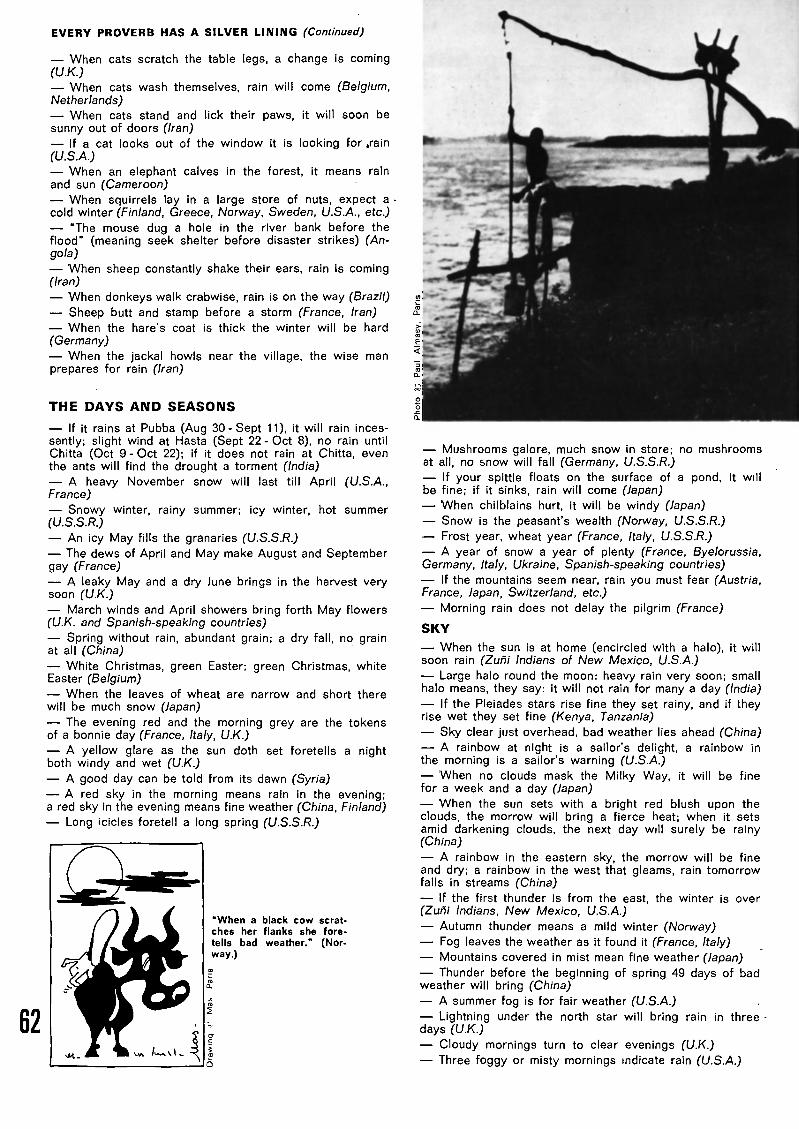
EVERY PROVERB HAS A SILVER LINING (Continued)
When cats scratch the table legs, a change is coming(UK.)
When cats wash themselves, rain will come (Belgium,Netherlands)
When cats stand and lick their paws, it will soon besunny out of doors (Iran)
If a cat looks out of the window it is looking for ,rain(U.S.A.)
When an elephant calves in the forest, it means rainand sun (Cameroon)
When squirrels lay in a large store of nuts, expect acold winter (Finland, Greece, Norway, Sweden, U.S.A., etc.)
"The mouse dug a hole in the river bank before theflood" (meaning seek shelter before disaster strikes) (An¬gola)
When sheep constantly shake their ears, rain is coming(Iran)
When donkeys walk crabwise, rain is on the way (Brazil)
Sheep butt and stamp before a storm (France, Iran)When the hare's coat is thick the winter will be hard
(Germany)
When the jackal howls near the village, the wise manprepares for rain (Iran)
THE DAYS AND SEASONS
If it rains at Pubba (Aug 30 - Sept 11), it will rain inces¬santly; slight wind at Hasta (Sept 22 - Oct 8), no rain untilChitta (Oct 9 - Oct 22); if it does not rain at Chitta, eventhe ants will find the drought a torment (India)
A heavy November snow will last till April (U.S.A.,France)
Snowy winter, rainy summer; icy winter, hot summer(U.S.S.R.)
An icy May fills the granaries (U.S.S.R.)
The dews of April and May make August and Septembergay (France)
A leaky May and a dry June brings in the harvest verysoon (UK.)
March winds and April showers bring forth May flowers(U.K. and Spanish-speaking countries)
Spring without rain, abundant grain; a dry fall, no grainat all (China)
White Christmas, green Easter; green Christmas, whiteEaster (Belgium)
When the leaves of wheat are narrow and short there
will be much snow (Japan)
The evening red and the morning grey are the tokensof a bonnie day (France, Italy, U.K.)
A yellow glare as the sun doth set foretells a nightboth windy and wet (U.K.)
A good day can be told from its dawn (Syria)
A red sky in the morning means rain in the evening;a red sky in the evening means fine weather (China, Finland)
Long icicles foretell a long spring (U.S.S.R.)
"When a black cow scrat¬
ches her flanks she fore¬
tells bad weather." (Nor¬way.)
Mushrooms galore, much snow in store; no mushroomsat all, no snow will fall (Germany, U.S.S.R.)
If your spittle floats on the surface of a pond, it willbe fine; if it sinks, rain will come (Japan)
When chilblains hurt, it will be windy (Japan)
Snow is the peasant's wealth (Norway, U.S.S.R.)
Frost year, wheat year (France, Italy, U.S.S.R.)
A year of snow a year of plenty (France, Byelorussia,Germany, Italy, Ukraine, Spanish-speaking countries)
If the mountains seem near, rain you must fear (Austria,France, Japan, Switzerland, etc.)
Morning rain does not delay the pilgrim (France)
SKY
When the sun is at home (encircled with a halo), it willsoon rain (Zuñi Indians of New Mexico, U.S.A.)
Large halo round the moon: heavy rain very soon; smallhalo means, they say: it will not rain for many a day (India)
If the Pleiades stars rise fine they set rainy, and if theyrise wet they set fine (Kenya, Tanzania)
Sky clear just overhead, bad weather lies ahead (China)
A rainbow at night is a sailor's delight, a rainbow inthe morning is a sailor's warning (U.S.A.)
When no clouds mask the Milky Way, it will be finefor a week and a day (Japan)
When the sun sets with a bright red blush upon theclouds, the morrow will bring a fierce heat; when it setsamid darkening clouds, the next day will surely be rainy(China)
A rainbow in the eastern sky, the morrow will be fineand dry; a rainbow in the west that gleams, rain tomorrowfalls in streams (China)
If the first thunder is from the east, the winter is over(Zuñi Indians, New Mexico, U.S.A.)
Autumn thunder means a mild winter (Norway)
Fog leaves the weather as it found it (France, Italy)
Mountains covered in mist mean fine weather (Japan)
Thunder before the beginning of spring 49 days of badweather will bring (China)
A summer fog is for fair weather (U.S.A.)
Lightning under the north star will bring rain in threedays (UK.)
Cloudy mornings turn to clear evenings (U.K.)
Three foggy or misty mornings indicate rain (U.S.A.)
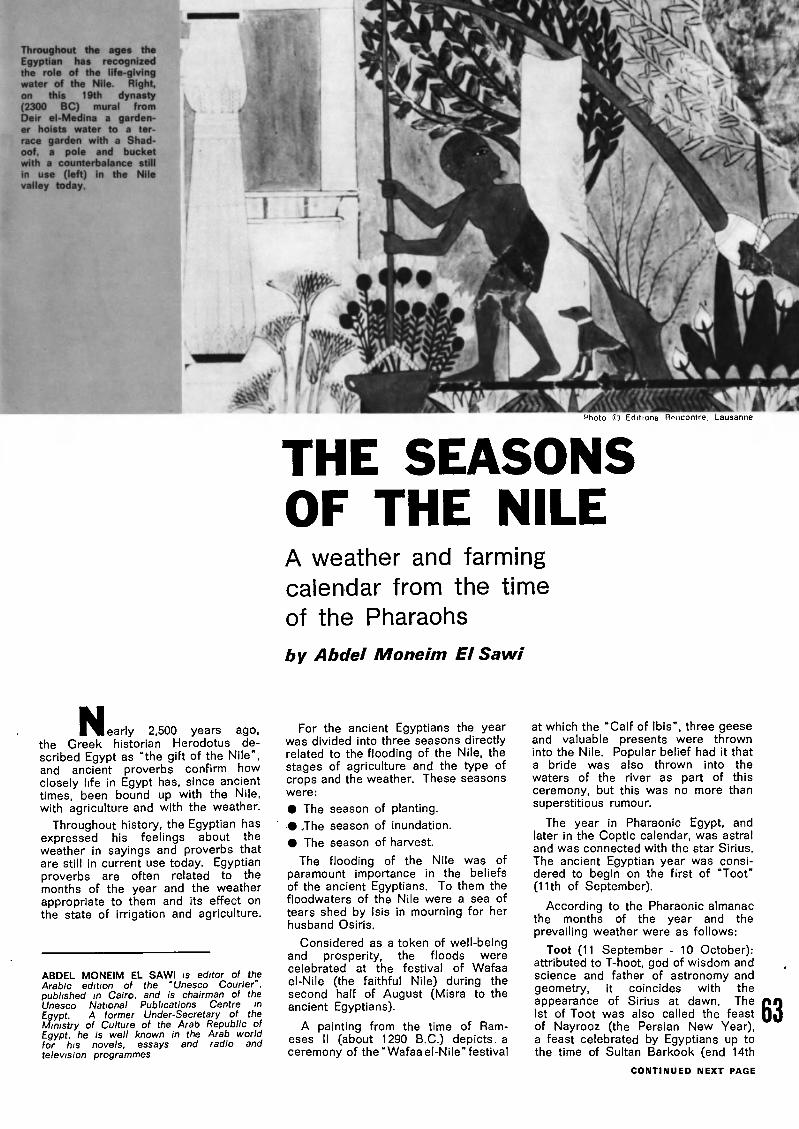
Throughout the ages theEgyptian has recognizedthe role of the life-givingwater of the Nile. Right,on this 19th dynasty(2300 BC) mural fromDeir el-Medina a garden¬er hoists water to a ter¬
race garden with a Shad¬oof, a pole and bucketwith a counterbalance still
in use (left) in the Nilevalley today.
^hoto !D Editions Rencontre, Lausanne
THE SEASONS
OF THE NILEA weather and farming
calendar from the time
of the Pharaohs
by Abdel Moneim El Sawi
N_ J early 2,500 years ago,the Greek historian Herodotus de¬scribed Egypt as "the gift of the Nile",and ancient proverbs confirm howclosely life in Egypt has, since ancienttimes, been bound up with the Nile,with agriculture and with the weather.
Throughout history, the Egyptian hasexpressed his feelings about theweather in sayings and proverbs thatare still in current use today. Egyptianproverbs are often related to themonths of the year and the weatherappropriate to them and its effect onthe state of irrigation and agriculture.
ABDEL MONEIM EL SAWI is editor of theArabic edition of the "Unesco Courier",published in Cairo, and is chairman of theUnesco National Publications Centre inEgypt. A former Under-Secretary of theMinistry of Culture of the Arab Republic ofEgypt, he is well known in the Arab worldfor his novels, essays and radio andtelevision programmes
For the ancient Egyptians the yearwas divided into three seasons directlyrelated to the flooding of the Nile, thestages of agriculture and the type ofcrops and the weather. These seasonswere:
The season of planting.
The season of inundation.
The season of harvest.
The flooding of the Nile was ofparamount importance in the beliefsof the ancient Egyptians. To them thefloodwaters of the Nile were a sea of
tears shed by Isis in mourning for herhusband Osiris.
Considered as a token of well-beingand prosperity, the floods werecelebrated at the festival of Wafaa
el-Nile (the faithful Nile) during thesecond half of August (Misra to theancient Egyptians).
A painting from the time of Ram-eses II (about 1290 B.C.) depicts, aceremony of the "Wafaa el-Nile" festival
at which the "Calf of Ibis", three geeseand valuable presents were throwninto the Nile. Popular belief had it thata bride was also thrown into the
waters of the river as part of thisceremony, but this was no more thansuperstitious rumour.
The year in Pharaonic Egypt, andlater in the Coptic calendar, was astraland was connected with the star Sirius.
The ancient Egyptian year was consi¬dered to begin on the first of "Toot"(11th of September).
According to the Pharaonic almanacthe months of the year and theprevailing weather were as follows:
Toot (11 September - 10 October):attributed to T-hoot, god of wisdom andscience and father of astronomy andgeometry, it coincides with theappearance of Sirius at dawn. TheIst of Toot was also called the feast
of Nayrooz (the Persian New Year),a feast celebrated by Egyptians up tothe time of Sultan Barkook (end 14th
CONTINUED NEXT PAGE
63

SEASONS OF THE NILE (Continued)
century). Toot is considered the startof the inundation period and oneproverb says "Irrigate in Toot or youwill be too late." It is thought to be abad time for the rearing of chickensand the hatching of eggs. "Chicks ofToot", runs one saying, "eat and die."
Baba (11 October - 9 November):attributed to the god of agriculture(Bee-net-ret). The floodlands dry outafter the inundation and winter cropsare harvested. During this month thereis the tempest of the big flood, whichlasts six days.
There is some wind and the first
signs of winter are seen. "Baba hasentered and has closed the roads",
says one proverb, meaning thatBaba is the time to close doors to
keep out the cold. "The bride of Babais blackened with smut", goes anothersaying, expressing the view that thismonth of change is an unsuitable onein which to get married.
Hatoor (10 November - 9 December):attributed to the gods of love, beautyand heaven. The land becomes
verdant, the cold becomes moreintense and the Nile waters become
clear again after the floods. Hatoor isconnected with rain and the growingof wheat: "Hatoor is the father of
scattered gold", and, "If you fail toplant in Hatoor, wait till the comingyear." To fishermen and sailors thisis the beginning of the stormy season.
Kiyahk (10 December - 8 January):attributed to the god of welfare(Kahaka). The days shorten and thenights lengthen: "In Kiyahk yourmorning takes the place . of yourevening." . . . "You rise from your bed
only to look for your supper." It is amonth of frost and intenser cold and
tempests.
Tooba (9 January - 7 February):attributed to the god Tobias theSupreme, the god of rains. The end ofTooba is marked by days of biting cold."Tooba makes the old woman crip¬pled", says one proverb, stressing thediscomfort caused to the elderly bythe cold.
Amsheer (8 February - 9 March):attributed to the god of tempests. Hotwinds cause buds to break into
blossom, but there are many tempests:"Amsheer tells the small plants tocatch up with the big plants." "Am¬sheer is the father of many tempests."A changeable month, Amsheer hasdays of biting cold and this has givenrise to one of the most common
proverbs: "The name is that of Tooba,but the act is that of Amsheer."
Baramhat (10 March - 8 April): Beansripen, the mulberry trees are green,silk worm eggs hatch out and ears ofcorn appear. It is the beginning ofspring: "In Baramhat go to the fieldsand get what you want." It is markedby the last and most violent tempest ofthe year, the two-day "howling tem¬pest": "There is no tempest like thehowling tempest."
Barmouda (9 April - 8 May): attri¬buted to the sacred snake, Remoota,the goddess of harvest. In this monthwheat and flax are harvested, honeyis gathered and bees multiply. As thisis the harvest season one saying goes:"In Barmouda strike the shafts", whichmeans strike the stems of flax toextract its fibres and thresh the corn.
Bashans (9 May - 7 June): attributedto the god of light. Days becomemuch longer than the nights, thetemperature rises and there is virtuallyno rain. This was the dry season whenthe Nile was at its lowest and the land
was bare and cracked after the harvest.
In the past it was said: "Bashanssweeps the ground completely." Thepicture has now changed, however,with various irrigation schemes andthe construction of the Aswan HighDam.
Ba-oona (8 June - 7 July): attributedto the god Khenti, god of minerals.Ba-oona means stone and during thismonth Egyptians used to leave theirfields and turn to mining and thebuilding of houses and temples. The11th of Ba-oona (17 June) is called"The Night of the Drop", because itwas believed that a divine teardropfell from heaven to cause the comingof the floods.
Abeeb (8 July - 6 August): its nameis derived from that of the god ofhappiness, Habi, to mark the comingof the floods. The floodlands are
opened to receive the floodwater andthe grapes become sweeter as theydrink up the Nile water and fruitsgenerally ripen: "Abeeb, the cook ofgrapes and raisins."
Misra (7 August - 5 September):attributed to Misra the Sun, or thechild of the sun. The temperaturedrops as a prelude to winter. It is theseason of floods and water. Summer
fruits become ripe, dates, figs andgrapes become abundant: "Misra isthe month in which each difficult canalruns."
WEATHER LORE DOWN THE AGESContinued from page 60
Drawing © Mas. Paris
64
where storms are raging, how the cur¬rents which carry them along move,which regions are likely to suffercyclones and which are likely to haveflat calm and mists.
Taking into account this up-to-dateinformation on what is happening bet¬ween ground level and an altitude of25 to 40 km., together with the physi¬cal laws and rules governing the at¬mosphere, they can foresee the aircurrents for the next day and follow¬ing days, pinpoint the cloud massesand the rain, in short, forecast theweather.
For some time now, they have beenable to do even better. The number
of instrument readings going to makeup the overall weather picture is sogreat, and the equations needed tocalculate their significance are so
complicated that it would take all the
meteorologists in the world several
months to work out the data required
for one twenty four-hour forecast. Bigmodern computers, however, once
they have been programmed to un¬derstand the laws of the atmosphere,can process all the information in anhour.
Bemusing, certainly, for those whobase their weather forecasts on hints
gleaned from plants or animals.
Though, during the process of civi¬lization, man may have lost some ofhis natural "instruments", he has re¬
placed them with scientific methods
that tell him far more accurately whe¬ther or not it will be fine tomorrow.
Roger Clausse

BOOKSHELF
Memories II
By Sir Julian HuxleyIn this second volume of his "Memo¬
ries", the famous British biologisttakes up the story with his appoint¬ment as first Director-General of
Unesco. George Allen and UnwinLtd., London, 1973 (£4.95).
A Natural History of Girafies
Pictures by Ugo Mochi, text by Dor¬cas MacClintock. Charles Scribner'sSons, New York, 1973 ($5.95).
Society in Conflict
By G. Hardy. Reform Publishing Co.,Melbourne, Australia. 1973
Man and the Social Sciences
Edited by William Robson. GeorgeAllen and Unwin Ltd., London, 1972
(hardback £5; paperback £1).
Revolution in China
By R.J. Saywell. Ginn and Co., Ltd,London, 1972.
The Unc!ean Planet
By RE. Baker and J.A. Bushel, Ginn,and Co., Ltd., London, 1972 (£1.25).
Environmental Quality and WaterDevelopment
Edited by Charles R. Goldman, JamesMcEvoy III and Peter J. Richardson.W.H. Freeman and Co., San Fran¬
cisco, U.S.A. and Reading, U.K..1973 (£8.40).
The United Nations and the
Population Question
By Richard Symonds and MichaelCarder, A Population Council Book.McGraw-Hill Book Company, NewYork. 1973 ($8.95).
Leisure and the Third Age
Proceedings of the Third Internatio¬nal Course of Social Gerontology,held at Dubrovnik in May 1972.International Center of Social Geron¬
tology, Paris, 1972, ($7).
The Roots of Civilization
By Alexander Marshack. McGraw-Hill Book Company. New York, 1972($17.50),
Cooking Our Way
Book I. A course in Caribbean
cookery and nutrition. By YvonneCollymore, illustrations by GeorgeGlaze. Caribbean Universities Press,
Barbados, Ginn and Co. Ltd., Lon¬
don, 1972 (75p).
Kenya's National Report to theUnited Nations on the Human Envi¬
ronment
National Committee on the Human
Environment, Nairobi, Kenya, 1972($2.80).
G3 rp Mtim ïBrazil's 'army
of knowledge'2,500,000 young Brazilians will do their
national service next year by joining in anation-wide adult literacy drive as studentsor teachers. Illiterate draftees will go asstudents to the literacy centre nearest totheir unit and those not required for theforces will attend classes part time duringthe regular 11 -month period of militaryservice.
Everythingunder the sun
A Unesco-sponsored congress on "Sunin the Service of Mankind", the largestof its kind ever held, recently brought 600scientists to Unesco's Paris H.Q. Embrac¬ing three major themes Sun and Life,Sun and Energy and Sun and Habitatstudies and discussions ranged overalmost "everything under the sun", fromsolar power plants and home cookers tothe effects of sunlight on plants andanimals.
No place like homefor accidents
Accidents are one of the three leadingcauses of death in many countries, withaccidents in the home accounting for alarge proportion of fatalities, says a WorldHealth Organization report. In the U.S.A.,during a single year, 20 million peoplewere injured in domestic accidents fivetimes more than the number injured onthe roads. The most common causes ofhome accidents are falls and burns.
India's women
book-lovers
In India more women than men read
books says a survey by the Indian Natio¬nal Book Trust. The survey also revealsthat 60 per cent of readers buy booksand the rest borrow from libraries or
friends. India is one of the world's majorbook-producing countries (its nationalbibliography lists an average of 11,200titles annually) but its total productionstill represents only 23 titles per millionof its population, as compared with 418per million people in Europe.
International responseto Borobudur appeal
Australia has contributed over $283,000and India has pledged $66,000 worth ofgoods and services for the preservationof the ancient Buddhist sanctuary of Boro¬budur in Indonesia. Other countries whichhave responded to Unesco's appeal forhelp in restoring Borobudur include Bel¬gium, Cyprus, France, Fed. Rep. of Ger¬many, Iran, Japan and the Netherlands.
New look at historyand geography
Several countries have recently takena fresh look at their history textbookswith the aim of removing stereotypedimages and age-old prejudices concern¬ing their neighbours. Co-operation bet¬ween Unesco National Commissions in
Austria and Italy has led to the publicationof a history book with a new approach,
"Austria and Italy", (1) which tells thestory of relations between the two coun¬tries with candour and objectivity. Text¬books incorporating a new view of Germa'-and Polish history from which prejudicedaccounts have been eliminated are about
to appear, following meetings organizedby the Fed. Rep. of Germany and PolishNational Commissions for Unesco. Educ¬
ators from the German Fed. Rep. andfrom Romania have proposed changes forimproving how each country is presentedin the other's geography books.
(1) 'Austria and Italy", by S/fWo Furlani and AdamWondruszka, published in German by Jugend undVerlagsgesellschaft, Vienna and Munich, and inItalian by Casa Éditrice L. Cappelli, Bologna.
African H.Q. for U.N.environment programme
Nairobi, Kenya, has been selected asheadquarters for the new U.N. Environ¬ment Programme which was launchedfollowing last year's U.N. StockholmConference on the Human Environment.
The programme, endorsed by the U.N.General Assembly last December, inclu¬des an "Earthwatch" pollution monitoringsystem, an international computerized ser¬vice for environmental information and a
"gene-bank" for conserving threatenedplant species. A 58-nation governingcouncil will oversee U.N. work on protec¬tion of the environment.
Cuban stampsaid Venice
Cuba's Ministry of Communications hasissued a special series of three stampsas a contribution to the Unesco-sponsoredinternational campaign to save Venice.Bearing the inscription, "Pro VeneciaUnesco", the stamps portray two famouslandmarks in Venice, the Bridge of Sighsand the Cathedral of St. Mark (shownbelow) and the winged lion emblem of theformer Venetian Republic.
Flashes...
Over half the world's population live inAsia (2,104 million persons representing56.7 per cent of the world total) accordingto the latest U.N. Demographic Yearbook.
Norway is helping Unesco to train radioand TV technicians and programme spe¬cialists In Upper Volta.
The U.S.S.R. is to build a city protectedby a transparent dome covering severalsq. km. in the oil-and-gas-producing regionof western Siberia.
The Fed. Rep. of Germany and Belgiumhave set up a 568,000-acre nature preservealong their common frontier in the northernEifel region.
The International Law Association cele¬
brates its centenary on August 30 withceremonies in Brussels, in co-operationwith the Institute of International Lawwhich will mark its centenary in Rome afew days later.
65

Letters to the Editor
SHREWD INSIGHT
Sir,
Bravo for Marcel Hicter's shrewd and
penetrating article "Drugs and Society",in your May 1973 issue. For the firsttime I find the problem of drugs exa¬mined in its proper context: present-day society in which youth is notalways guilty and adults are not alwaysinnocent.
Serge GuerotVillebon-sur-Yvette, France
SCIENCE AND MYTH
Sir,
Your issue on "Science and Myth"(February 1973) is a timely step towardsthe debunking of beliefs which tend tomake some people accept myths thatare contrary to the laws of science.
This is true of all myths. They aresimply legends concocted with a basisof historical or scientific fact and pre¬sented to the public as factual orreligious truths.
The more science broadens our hori¬
zons, the better we become aware ofthe false reasoning on which religionsare based, even though they all havea foundation of morality and of sociallaws and custom.
Congratulations too for your issue"The Emergence of Man" (August-Sep¬tember 1972). Its examination of thequestion of the origins of man on thebasis of scientific fact was a first steptowards the démystification of thissubject.
M. CapdevilleToulouse, France
CARTHAGE. LIVING SYMBOL
OF THE PAST
Sir,
I am 18 years of age and a collegestudent. Just recently I read about theproject to save the ruins of Carthage.(See also "Carthage must not be des¬troyed", "Unesco Courier", December1970.) I don't know if my letter willhelp much, but ¡t is my way of showingyou that I am concerned too.
I have never been to Carthage, butI have been to Rome and to Ostia
Antica, in Italy, and they impressed memore than anything else I have everseen. The sheer power and beauty ofthose ruins have impressed me eversince, and I often think of them. To
destroy any such ruins is a crimeagainst humanity. These ruins are notjust ruins; they have inspired artists,writers, and poets, of all ages, and forsome people like me they bring to lifethat great period of our past likenothing else can. I have stood in theruins of the Colosseum for 1J hours,
just imagining how it was then. I wouldhate to see the ruins of another greatcity, such as Carthage, destroyed.It would be different if these ruins no
longer gave anyone inspiration, a senseof beauty or the past, or any answers.The fact is, we still gather inspirationand the sense of beauty and past, weare still finding answers to our pasthistory and we are still learning fromthese. To me, the beauty, impressive-ness, and uniqueness of the ruins are
reasons enough for not destroyingthem. Too many people don't stop tothink In the rush of progress, that allof the things we get from these ruinsof our past, once destroyed, can neverever again be replaced. It would beone of the great idiocies of our timeif they were covered over in the con¬crete of "progress".
I hope that your efforts to save themwill be rewarded, and for all of us who
are behind you please don't stop trying.As Macaulay wrote: "People who takeno pride in the noble achievements ofremote ancestors will never achieve
anything worthy to be remembered withpride by remote descendants."
Marian E. SeidersAnaheim
California, U.S.A.
OUR WINDMILLS WERE TILTED
Sir,
I was delighted to see that yourinteresting issue "Music of the Centu¬ries" (June 1973) marked the cente¬nary of Fedor Chaliapin. But I wassurprised to read in the caption accom¬panying the photo of the great bass(page 14) that it showed him in thetitle role of Richard Strauss' "Don
Quixote". The "Don Quixote" compos¬ed by Richard Strauss in 1898 was awork for 'cello and orchestra and
therefore could not have been sung byChaliapin.
Works based on Cervantes' famous
character have been written by a scoreof composers Including Purcell, Conti,Salieri, Von Dittersdorf, Massenet andPierné.
Jules Massenet's "Don Quixote", firstperformed at the Monaco Opera Housein 1910, provided Chaliapin with oneof his most striking roles. Later, in1934, Chaliapin appeared as DonQuixote in a film directed by G. W.Pabst, though this was not an adapt¬ation of Massenet's work. Commission¬
ed to write the score, Ravel eventuallywithdrew, but not before he had writtenhis admirable "Three songs of DonQuixote to Dulcinea". The film scorewas ultimately written by Jacques Ibertand it is more than likely that yourphoto is a still from this film.
Hubert Gassart
Neuilly, France
A MATTER OF RELATIVITY
Sir,
Why all this controversy about whe¬ther the sun goes round the earth orvice versa (Letters to the Editor, June1973) following Jean-Claude Pecker'sarticle "Copernicus as told to children"(April 1973) issue.
Did you not know that / am thecentre of the Universe (my Universe)?
As I sit here, I feel that / am still, and
everything else moves round me ortowards me or away from me.
But I know that you are the centreof your universe and so long as Irecognize this and you recognize that I,also, am the Centre, we shall notquarrel or come to any harm from eachother.
Everything will be O.K. for both of us.
It Is all a matter of relativity!
Iris Sharratt
Headmistress
Secondary Modsrn School for Girls,Dereham Norfolk, U.K.
RASH ASSERTIONS?
Sir,
I would like to comment on the
article "Copernicus as told to children"by Jean-Claude Pecker, in your fascin¬ating issue on Copernicus (April 1973).
There are those who still share not
only Copernicus' love of science butalso his religious faith. I'm sure Coper¬nicus would have been unhappy to readin Prof. Pecker's article that "One
day... we'll have to admit that the old(Biblical) legends were lovely storiesand perhaps nothing more". The Biblestories of the Creation are not
"legends", but myths writings full ofimagery (with no pretensions to beingscientific) and expressing a religioustruth.
And isn't It rather rash to assert that
"Man is a highly developed animal,but in the universe there must certainlybe others even more highly developed"?I question this statement not on reli¬gious grounds but on the basis ofexisting scientific data. Shouldn't webe more circumspect about the possi¬bility that other planets, Identical orsimilar to the earth and Inhabited, existin other galaxies?
Father Jules Dubois
Boboto CollegeKinshasa, Zaire
TOO MANY ACCIDENTS
Sir,
In recent years the "Unesco Courier"has dealt at length with two burningissues of world health cardiovascular
disease (April 1972) and cancer (May1970).
World Health Organization surveysshow that accidents are another crucial
issue which needs to be spotlighted.Accidents have become a modern
scourge and their prevention is now aleading social problem. Though acci¬dent figures in the U.S.S.R. are lowerthan in many other countries, theproblem is no less pressing here.
All countries are undoubtedly focuss¬ing their attention on this question. Itwould be interesting to read about theirvarious approaches, achievements andplans, and to have the opinions ofexperts who study the causes of acci¬dents. The prevention and eliminationof accidents equally concerns researchestablishments, design offices, sociolo¬gical laboratories, factories, transportorganizations and medical institutes. Itwould also be stimulating to hear whatphilosophers have to say on thissubject.
Victor DegtyarevMoscow, U.S.S.R.
The Unesco Courier devoted an
entire issue (April 1961 "AccidentsNeed Not Happen") to the subject ofaccidents and their prevention. Seealso "Unesco Newsroom" in our current
issue Editor.

Just published by Unesco:
Volume II
New trends
in integratedscience
teaching
Three new volumes in the series
THE TEACHING OF BASIC SCIENCES
New trends in integrated science teaching. Vol. II
A timely and searching analysis of recent developments
in integrated science teaching.
1973 239 pp. 24 F
New trends in mathematics teaching, Vol. Ill
A key reference work on programme planning and supervision
of mathematics teaching from the kindergarten upwards.
1973 145 pp. 14 F
New trends in chemistry teaching. Vol. Ill
An international presentation of articles and studies from leading
science-teaching journals on content, approaches and techniques
in chemistry teaching.
Î972 Bilingual : English-French 325 pp. 28 F
Where to renew your subscriptionand order other Unesco publications
Order from any bookseller or write direct tothe National Distributor in your country. (See listbelow ; names of distributors in countries notlisted will be supplied on request.) Payment ismade in the national currency ; the rates quotedare for an annual subscription to THE UNESCOCOURIER in any one language.
AUSTRALIA. Publications : Educational SuppliesPty. Ltd., P.O. Box 33, Brookvale, 2100, NSW;Periodicals: Dominie Pty. Limited, Box 33, PostOffice, Brookvale 2100, NSW. Sub-agent: UnitedNations Association of Australia, Victorian Division
5th (loor, 134/136 Flinders St., Melbourne(Victoria), 3000. ($ Aus 3.60) AUSTRIA.Verlag Georg Fromme & C*., Arbeitergasse 1-7, 1051,Vienna (AS 110). BELGIUM. "Unesco Courier"Dutch edition only : N.V. HandelmaatschappijKeesing, Keesinglaan 2-18, 2100 Deurne-Antwerpen.(250 F belges). French edition and general Unescopublications agent : Jean de Lannoy, 112, rue duTroné, Brussels 5. CCP 3380.00. - BURMA. TradeCorporation N* (9), 550-552 Merchant Street, Rangoon.
CANADA. Information Canada, Ottawa, (Ont.)(8 5,00). CYPRUS. "MAM", Archbishop Maka-rios 3rd Avenue, P.O. Box 1722, Nicosia.CZECHOSLOVAKIA. S.N.T.L., Spalena 51, Prague 1(permanent display); Zahranicni literatura, 1 1 SoukenickaPrague 1. For Slovakia only : Alfa Verlag - Publishers,Hurbanovo nam. 6, 893 31 Bratislava - CSSR.DENMARK. Munksgaards Boghandel. 6, Norregade,DK-1165, Copenhagen K. (Dan. Kr. 27.00) EGYPT(ARAB REPUBLIC OF). National Centre for UnescoPublications, N* 1 Talaat Harb Street, Tahrir Square,Cairo; Librairie Kasr El Nil, 38, rue Kasr El Nil, Cairo.(IL.E. 3 5). -ETHIOPIA. National Commission for Unesco,P.O.Box 2996, Addis Ababa. FINLAND, AkateeminenKiriakauppa, 2 Keskuskatu, Helsinki (Fmk. 13.90).FRANCE. Librairie de l'Unesco, 7-9, piace de Fontenoy,75700-Paris. CCP. 12598-48 (17 F). - GERMANDEMOCRATIC REP. Deutscher Buch-Export und
Import Gmbh, Leninstrasse 16, 701 Leipzig. FED. REP.OF GERMANY All publications: Verlag Dokumentation,Postfach 148, Jaiserstrasse 13, 8023 Munchen-Pullach.For the Unesco Kurier (German ed only) Bahrenfelder-Chaussee 1 60, Hamburg-Bahrenfeld, CCP. 276650(DM 1 6). GHANA. Presbyterian Bookshop DepotLtd., P.O. Box 195, Accra; Ghana Book Suppliers Ltd.,P.O. Box 7869, Accra ; The University Bookshop of Ghana.Accra; The University Bookshop of Cape Coast, TheUniversity Bookshop of Legon, P.O. Box 1, Legon.GREAT BRITAIN. See United Kingdom.
GREECE. Anglo- Hel lenic Agency,
5, Koumpari Street Athens 138; HONG-KONG.Swindon Book Co., 1 3-1 5, Lock Road, Kowloon.HUNGARY. Akadémiai Kónyvesbolt. Váci u. 22,Budapest V; A.K.V. Konyvtárosok Boltja, Népkóztársaságutja 16, Budapest VI. ICELAND. Snaebjorn Jonssonii Co., H. F., Hafnarstraeti 9, Reykiavik. INDIA.Orient Longman Ltd., Nicol Road, Ballard Estate, Bom¬bay 1; 1 7 Chittaranjan Avenue, Calcutta 13; 36a, AnnaSalai, Mount Road, Madras 2;B-3/7Asaf Ah Road, NewDelhi 1 ; Sub-Depots: Oxford Book & Stationery Co.17 Park Street, Calcutta 16; and Scindia House, NewDelhi; Publications Section, Ministry of Educationand Youth Services, 72 Theatre CommunicationBuilding, Connaught Place, New Delhi 1. (Rs. 18,75).- INDONESIA. Indira P. T., Jl. Dr. Sam Ratulangie37, Jakarta. IRAN. Kharazmie Publishing and Distri-,bution C*., 229 Daneshgahe Street, Shah Avenue, P.O.Box 14-1486, Teheran. Iranian National Commissionfor Unesco, Avenue Iranchahr Chomali No 300,B.P. 1533, Teheran. IRAQ. McKenzie's Bookshop,Al-Rashid Street, Baghdad; University Bookstore, Uni-versity of Baghdad, P.O. Box 75, Baghdad. IRELAND.The National Press, 2. Wellington Road, Ballsbridge,Dublin 4. ISRAEL. Emanuel Brown, formerlyBlumstein's Bookstores, 35 Allenby Road and 48, NachlatBenjamin Street, Tel-Aviv; 9, Shlomzion Hamalka StreetJerusalem. (24 I.L.) Sangster's Book StoresLtd., P.O. Box 366, 101 Water Lane, Kingston.JAPAN. Maruzen Co. Ltd., P.O. Box 5050, TokyoInternational 1 00-31(Y 1,440).- KEN YA.The E.S.A. Ltd.,P.O. Box 30167, Nairobi. KOREA. Korean NationalCommission for Unesco, P.O. Box Central 64, Seoul.KUWAIT. The Kuwait Bookshop Co., Ltd., P.O. Box2942, Kuwait. LIBERIA. Cole and Yancy BookshopsLtd., P.O. Box 286, Monrovia. LIBYA. Agency forDevelopment of Publication & Distribution, P.O. Box 34-35, Tripoli. LUXEMBOURG. Librairie Paul Brück,22, Grand -Rue, Luxembourg. MALAYSIA.Federal Publications Sdn. Bhd., Balai Berita, 31, JalanRiong, Kuala Lumpur. MALTA. Sapienza's Library,26 Kingsway, Valletta. MAURITIUS. Nalanda Com¬pany Ltd., 30, Bourbon Street, Port-Louis (Rs. 17,45).MONACO. British Library, 30, Bid des Moulins, Monte-Carlo. NETHERLANDS. For the « Unesco Koerier»
Dutch edition only : Systemen Keesing, Ruysdaelstraat71-75. Amsterdam-1007 (fl. 1 7.50). Agent for all Unescopublications : N. V. Martinus Nijhoff, Lange Voorhout,9, The Hague. NETHERLANDS ANTILLES.G. C T. Van Dorp & Co. (Ned Ant.). N.V.,Willemstad, Curacao. N. A. (NA fl. 7.80).
NEW ZEALAND. Government Printing Office,Government Bookshops at : Rutland Street, P.O. Box5344, Auckland; 130, Oxford Terrace, P.O. Box 1721.Christchurch; Alma Street, P.O. Box 857, Hamilton;
Princes Street, P.O. Box 1104, Dunedin; Mulgrav«Street, Private Bag, Wellington (8 3.00). NIGERIAThe University Bookshop of Ife, The University Bookshopof Ibadan, P.O. Box 286; The University Bookshop ofNsukka; The University Bookshop of Lagos The AhmaduBello University Bookshop of Zaria. NORWAY. Allpublications : Johan Grundt Tanum (Booksellers) Karljohans gate 41/43, Oslo 1. For Unesco Courier only : A. S.Narvesens Litteraturtjeneste, Box 61 25, Oslo6 (K. 23,00).-PAKISTAN. The West-Pak Publishing Co. Ltd., UnescoPublications House, P.O. Box 374 G.P.O., Lahore;Showrooms: Urdu Bazaar, Lahore, and 57-58 MurreeHighway, G/6-1, Islamabad. Pakistan Publications Book¬shop, Sarwar Road, Rawalpindi. Mirza BookAgency 65 Shahrah Quaid e-azam, P.O. BoxN\ 729, Lahore-3 PHILIPPINES. The ModernBook Co., 926 Rizal Avenue, P.O. Box632. Manila D-404. POLAND. All publications :ORWN PAN Palac Kultury i Nauki, Warsaw.For the Unesco Courier only RUCH, ul.Wronia, 23, Warsaw 1 0. PORTUGAL. Dias & AndradeLtda, Livrana Portugal, rua do Carmo 70, Lisbon (Esc.1 05).
SINGAPORE. Federal Publications Sdn Bhd., TimesHouse, River Valley Road, Singapore 9. SOUTHERNRHODESIA. Textbook Sales (PVT) Ltd., 67 UnionAvenue, Salisbury. SRI LANKA. Lake House Book¬shop, 100 SirChittampalam Gardiner Mawata P.O.B. 244Colombo 2. (Rs 25). - SUDAN. AI Bashir Bookshop,P.O. Box 1 1 1 8, Khartoum. SWEDEN. All publications:A/B CE. Fntzes Kungl. Hovbokhandel, Fredsgatan 2,Box 16356, 10327 Stockholm 16. For the Unesco
Courier : Svenska FN-Forbundet, Skolgrand 2, Box 1 5050 S-104 65, Stockholm (Kr. 18). - SWITZERLAND.All publications : Europa Verlag, 5 Ramistrasse,Zurich. Librairie Payot, rue Grenus 6, 1211,Geneva 11, CCP. 12-236 (Fr. S. 16.-). TAN-ZANIA. Dar-es-Salaam Bookshop, P.O.B. 9030 Dar-es-Salaam. THAILAND. Suksapan Panit, Mansion 9,Ra/damnern Avenue, Bangkok. (71.00 bäht). TURKEY,Librairie Hachette, 469 Istiklal Caddesi, Beyoglu, Istanbul.
UGANDA. Uganda Bookshop, P.O. Box 1 45, Kampala.SOUTH AFRICA. All publications: Van Schaik's
Bookstore (Pty). Ltd., Libri Building, Church Street, P.O.Box 724, Pretoria. For the Unesco Courier (single copies)only: Central News Agency P.O. Box 1033, Johannesburg.UNITED KINGDOM. H.M. Stationery Office, P.O.Box 569, London, S.E.I., and Government Bookshopsin London, Edinburgh, Cardiff, Belfast, Manchester,Birmingham, Bristol (£1,30).UNITED STATES. UnescoPublications Center, P.O. Box 43 3, New York, N.Y.10016 ($5). U.S.S.R. Mezhdunarodnaia Kniga,Moscow, G-203. YUGOSLAVIA. JugoslovenshaKnjiga, Terazi|->, 27, Belgrade; Drzavna Zalozba SI«»-veniie Mestni Trg. 26, Ljubljana.

Photo © CIRIC, Geneva
Drought over AfricaThis young African, eagerly slaking his thirst with a trickleof water from a gourd, is one of millions today sufferingthe catastrophic effects of a drought that stretches acrossthe African continent from Mauritania on the west coast
to the Sudan in the east. During the past seven years, declin¬ing rainfall in this immense area of Africa south of theSahara has destroyed crops, decimated herds and forceduntold numbers of persons into an unprecedented migrationin search of food and water (see article page 44).