uttrakhand disaster
TRANSCRIPT

UTTARAKHAND DISASTER: MAN MADE
OR NATURE’S FURY..

Overview of Uttarakhand Flooding in Uttrakhand Other affected regions How local people looted pilgrims. Consequences Rescue and relief operations. Causes of the disaster Measures to reduce the intensity
OUTLINE

Uttarakhand has a total land area of 53,584sqkm of which 94% is mountaneous.
Most of the area is covered by himalayan peaks and glaciers.
Two major rivers(Ganga and yamuna) originate from the glaciers of uttarakhand
OVERVIEW OF UTTRAKHAND

BADRINATH TEMPLE KEDARNATH TEMPLE
GANGOTRI TEMPLE YAMONOTRI TEMPLE
THE CHAR DHAM

From 15 to 18 June 2013, Indian state of Uttrakhand and adjoining area received heavy rainfall, which was about 375 percent more than the benchmark rainfall during a normal monsoon.
16th and 17th June,2013The Day of Destruction happened in history of
UTTRAKHAND
FLOODING IN UTTRAKHAND…

The massive rainfall and cloud burst events were happening at multiple places, including in Bhagirathi basin, Assiganga basin, Mandakini Basin, Badrinath region, other places in Alaknanda region from 15 June 2013 to around 18 June 2013.
It is considered to be the largest natural disaster after tsunami occurred in 2004
This lead to melting of Chorabari Glacier at the height of 3800 metres, and eruption of the Mandakini River which led to heavy floods near Kedar Dome, Rudraprayag district, Uttarakhand, Himachal Pradesh.

CONSEQUENCES:HUMAN LOSS
Landslides, due to the floods, damaged several houses and structures, killing those who were trapped Over 70,000 people were stuck.
According to the official records 400 houses were destroyed and 265 were damaged
4,200 villages were victims of
the floods
6,000 people were dead,10,000 were injured and 1,00,000 were stuck in the valley

Major roads,telephone towers were destroyed due to which communication with the outer world was lost.
Tourism constitutes about 30% of the state’s income which was lost
All the shops and hotels were
destroyed and all roads were broken
CONSEQUENCES:ECONOMIC LOSS
20,000 crores loss was reported,which may be in the form of destruction of houses roads,cars e.t.c

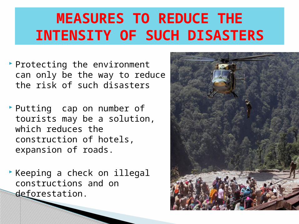
RESCUE AND RELIEF OPERATION The Army, Air Force, Navy, Indo-Tibetan
Border Police (ITBP), Border Security Force, National Disaster Response Force (NDRF), Public Works Department and local administrations worked together for quick rescue operations.
Several thousand soldiers were deployed for the rescue missions.
Activists of political and social organizations are also involved in the rescue and management of relief centres.
Helicopters were used to rescue people, but due to the rough terrain, heavy fog and rainfall, maneuvering them was a challenge.

By 21 June 2013, the Army had deployed 10,000 soldiers and 11 helicopters, the Navy had sent 45 naval divers, and the Air force had deployed 43 aircraft including 36 helicopters.
From 17 June to 30 June 2013, the IAF airlifted a total of 18,424 people - flying a total of 2,137 sorties and dropping/landing a total of 3,36,930 kg of relief material and equipment.
Prime Minister of India undertook an aerial survey of the affected areas and announced 1,000 crore (US$170 million) aid package for disaster relief efforts in the state. Several state governments announced financial assistance,

Special trains were employed by the government all over the country to cater the needs of the flood victims
Indian army showed extreme
levels of courage in saving the people in spite of the helicopter crash occurred during the mission-operation Rahat.

Even the Corporates joined hand to help the people..

Melting of glaciers, because of global warming has been of the reasons. Pollution and global warming accounted for the melting of glaciers
Violation of environmental laws and deforestation has also accounted for floods.
Building of hydro electricity plants and increase in the infrastructural facilities have weaken the mountain causing land slides.
CAUSES OF THE DIASTER

Ecologists point out that the huge expansion of hydro-power projects and construction of roads to cope with the lakhs of tourists in Uttarakhand and Himachal Pradesh has compounded the scale of the disaster
Currently 70 dams exist in the Char dham area alone.The dam constructions involve blasting of hills which increase the risk of land slides.
More than 220 power and mining projects are running in 14 river valleys in Uttrakhand.
Several rivers are being diverted through tunnels for these projects leadung to major disasters in the state.
Protecting the environment can only be the way to reduce the risk of such disasters
Putting cap on number of tourists may be a solution, which reduces the construction of hotels, expansion of roads.
Keeping a check on illegal constructions and on deforestation.
MEASURES TO REDUCE THE INTENSITY OF SUCH DISASTERS

Using latest equipments to
predict the probability of rains
Alerting and transferring people to safe zones at proper time.
Training the people on how to take basic safety measures.
