usgs - u.s. geological survey publications warehouse · 2010-08-07 · population and expanding...
TRANSCRIPT

USGSscience fora changing world VIRGINIA DEPARTMENT OF
ENVIRONMENTAL QUALITY
USGS Ground-Water Flow ModelAn Essential Tool for Managing the Water Supply of the Virginia Coastal Plain
Virginia needs a reliable water
supply to sustain its growing
population and expanding economy.
In 1990, the aquifers in the Coastal
Plain supplied about 100 million
gallons per day (mgd) to the citizens,
businesses, and industries of Virginia.
It is estimated that by the year 2000,
demand will increase by another 10
mgd and likely will continue to
increase in future years.
Ground water is the only source
of usable water in rural areas of the
Coastal Plain and increasingly is
being used to support a growing urban
population. Current withdrawals have
led to declining water levels in most
Coastal Plain aquifers. Further
declines are likely to occur, posing a
threat that saltwater will move into
parts of these freshwater aquifers.
How can we sustain this important water supply?
To ensure that the Coastal Plain aquifers do not become overdrawn, the Commonwealth of Virginia regu lates large ground-water withdrawals in ground-water management areas. A computer model of regional ground-water flow developed by the USGS is used by the Virginia Depart ment of Environmental Quality (DEQ) to permit new water-supply wells and to assess long-term stresses to the ground-water system. Local communities use results from the Coastal Plain model to plan for their future water-resource needs. The model is a useful and well-accepted tool for supporting many important ground-water management decisions.
The model needs to be fine-tuned periodically so that it will continue to support wise ground-water manage ment decisions into the 21st century.
Coastal Plain aquifers supply water to Virginia homes ...
.. . businesses and industry ...
oZi >-
120
100
80
60
40
20
(Estimate)
Withdrawal*\
n H1960
YEAR
2,500,000
2,000,000
1,500,000 p
1,000,000 O
Population and ground-water use are increasing in the Virginia Coastal Plain. *Based on DEQ data. **Based on Census Bureau data.
... and agriculture.
U.S. Department of the Interior U.S. Geological Survey
USGS Fact Sheet 099-99 June 1999

Does heavy ground-water use affect everyone?
Yes. Large withdrawals can have wide-ranging effects that cross city, county, and even state boundaries. In the Northern Neck of Virginia, for example, ground-water levels and flow probably have been altered by pumping in southern Maryland.
Excessive ground-water with drawals can mean
less water available for private and public supplies because of declin ing water levels
higher water bills as pumping costs increase
conflict among users of ground water
degraded water quality from salt water intrusion (saltwater moving into freshwater areas)
reduced streamflow, which harms fish and other aquatic life as well as opportunities for recreation
Development and uses of the Coastal Plain model
The ground-water flow model was developed by the USGS in the early 1980s to help scientists better understand the flow system in the Coastal Plain and how it is affected by withdrawals. Since then, USGS hydrologists have worked with DEQ to revise the model: more current information on the aquifer system has been incorporated, and simulations have been performed using updated data on withdrawals.
The model is used to
examine trends in ground-water levels and flow rates
evaluate the cumulative impact of actual withdrawals
predict the effects of proposed large-scale withdrawals that will affect more than one aquifer
Because the Coastal Plain aqui fers are greatly stressed in Hampton Roads and other areas, users of large amounts of ground water (300,000 or more gallons per month) from a des ignated ground-water management area must obtain a ground-water with drawal permit. DEQ uses the model to determine the "area of impact'1 for withdrawals proposed by these permit applications.
In 1992, the Ground Water Man agement Act decreased the term of withdrawal permits once good for life, the permits now must be renewed every 10 years and users are allowed to withdraw only as much ground water as needed to serve cur rent demands. This policy was influ enced by model simulation results, which predicted that increased pump ing in southeastern Virginia would lead to "considerable well interfer ence among ground-water users and potential degradation of water qual ity" (Hamilton and Larson, 1988).
The Virginia Coastal Plain Aquifer System
Besides saltwater, majorboundaries to ground-water flow are underlying BEDROCK and the FALL LINE, / which separates the relatively impervious rock of the Piedmont province from the more permeable Coastal Plain sediments.
Most ground water comes fromrainwater recharge that percolatesdown to the water table.The FALL ZONE, which is the western marginof the Coastal Plain, is a major recharge area.
Atlantic Ocean
0 10 20 KILOMETERS
Arrows show direction of GROUND-WATER FLOW, which is primarily in a down-dip direction to the east, toward areas of discharge such as streams and rivers, pumping wells, the Chesapeake Bay, and the Atlantic Ocean.
At the SALTWATER INTERFACE, density differences between fresh and saltwater force ground water upward.
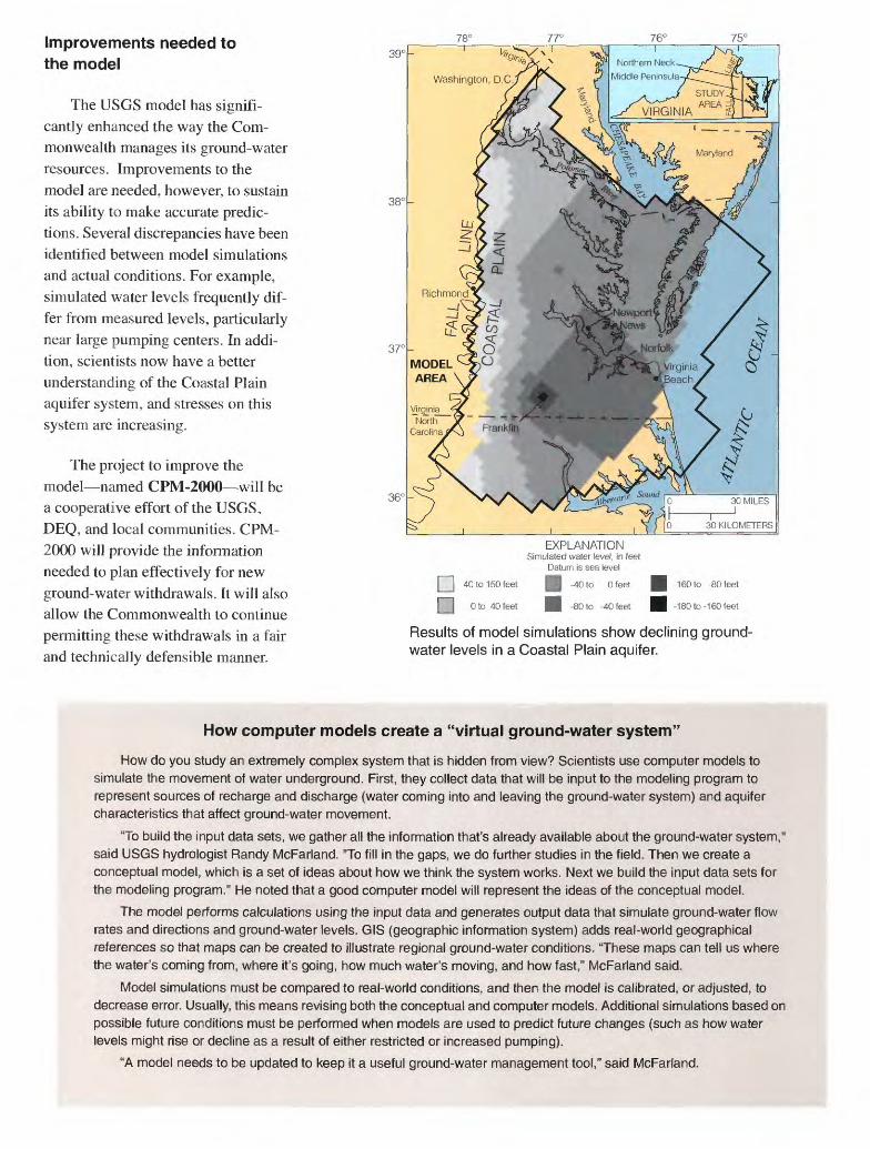
Improvements needed to the model
The USGS model has signifi cantly enhanced the way the Com monwealth manages its ground-water resources. Improvements to the model are needed, however, to sustain its ability to make accurate predic tions. Several discrepancies have been identified between model simulations and actual conditions. For example, simulated water levels frequently dif fer from measured levels, particularly near large pumping centers. In addi tion, scientists now have a better understanding of the Coastal Plain aquifer system, and stresses on this system are increasing.
The project to improve the model named CPM-2000 will be a cooperative effort of the USGS, DEQ, and local communities. CPM- 2000 will provide the information needed to plan effectively for new ground-water withdrawals. It will also allow the Commonwealth to continue permitting these withdrawals in a fair and technically defensible manner.
[ | 40 to 150 feet
[ | Oto 40 feet
EXPLANATIONSimulated water level, in feet
Datum is sea level
| -40 to 0 feet
H -80 to -40 feet
-160 to -80 feet
-180 to-160 feet
Results of model simulations show declining ground- water levels in a Coastal Plain aquifer.
How computer models create a "virtual ground-water system"
How do you study an extremely complex system that is hidden from view? Scientists use computer models to simulate the movement of water underground. First, they collect data that will be input to the modeling program to represent sources of recharge and discharge (water coming into and leaving the ground-water system) and aquifer characteristics that affect ground-water movement.
"To build the input data sets, we gather all the information that's already available about the ground-water system," said USGS hydrologist Randy McFarland. "To fill in the gaps, we do further studies in the field. Then we create a conceptual model, which is a set of ideas about how we think the system works. Next we build the input data sets for the modeling program." He noted that a good computer model will represent the ideas of the conceptual model.
The model performs calculations using the input data and generates output data that simulate ground-water flow rates and directions and ground-water levels. GIS (geographic information system) adds real-world geographical references so that maps can be created to illustrate regional ground-water conditions. "These maps can tell us where the water's coming from, where it's going, how much water's moving, and how fast," McFarland said.
Model simulations must be compared to real-world conditions, and then the model is calibrated, or adjusted, to decrease error. Usually, this means revising both the conceptual and computer models. Additional simulations based on possible future conditions must be performed when models are used to predict future changes (such as how water levels might rise or decline as a result of either restricted or increased pumping).
"A model needs to be updated to keep it a useful ground-water management tool," said McFarland.

CPM-2000 will include new and updated information about
Coastal Plain aquifers USGS will gather more data on the Northern Neck and Middle Peninsula, which are among the least well-under stood parts of the aquifer system. Within the next 5-10 years, these areas in the northern portion of the Coastal Plain will likely be part of Virginia's designated ground-water management area.
Effects of the Chesapeake Bay impact crater USGS scientists recently have discovered that a comet or meteorite struck the Earth about 35 million years ago near the present-day mouth of the Chesa peake Bay. The resulting 56-mile wide crater severely disrupted sev eral Coastal Plain aquifers and
78'
created Virginia's "inland saltwa ter wedge" that limits the amount of fresh water available in the lower bay region (Powars and oth ers, 1994). Several ground-water withdrawal projects in the Hamp ton Roads area are near the crater's outer rim. In order to accurately simulate withdrawals and ground- water flow in this area, information about the effects of the impact cra ter will be incorporated into the model.
Connections between ground and surface water The model will incorporate recently discovered connections between the aquifers and the streams and rivers along the Fall Zone. These connections could be significantly affecting the availability of ground water in the Coastal Plain.
36°-
The effects of the Chesapeake Bay impact crater will be incorporated into the model. Dotted line shows the extent of the "inland saltwater wedge," where fresh ground water meets salty water in the middle Potomac aquifer.
Effects of increasing withdraw als Large withdrawals are occur ring in areas near the boundaries of the model, such as in Hampton Roads, in southern Maryland along the Potomac River, and along the Fall Zone. More accurate simula tions are needed of how water lev els respond to these withdrawals. After comparing results of simula tions with current data on with drawals, the model will be recalibrated to better represent cur rent ground-water conditions.
Martha L. Erwin and E. Randolph McFarland, USGS, and T. Scott Bruce, Virginia Department of Environmental Quality
Fact sheet based onMcFarland, E.R., 1998, Design, revisions, and con
siderations for continued use of a ground-water- flow model of the Coastal Plain aquifer system in Virginia: U.S. Geological Survey Water Resources Investigations Report 98-4085, 49 p.
References cited
Hamilton, P.A., and Larson, J.D., 1988, Hydrogeol- ogy and analysis of the ground-water flow system in the Coastal Plain of southeastern Virginia: U.S. Geological Survey Water Resources Investiga tions Report 87-4240, 175 p.
Powars, D.S., Bruce, S., Poag, C.W., and Mixon, R.B., 1994, Virginia's coastal plain inland salt water wedge A geohydrological response to the Chesapeake Bay bolide impact [abs.]: Geological Society of America, Abstracts with Programs, v. 26, p. 410.
Additional references
Harsh, J.F., and Laczniak, R.J., 1990, Conceptualiza tion and analysis of the ground-water flow system in the Coastal Plain of Virginia and adjacent parts of Maryland and North Carolina: U. S. Geological Survey Professional Paper 1404-F, 100 p.
Laczniak, R.J., and Meng, A.A. Ill, 1988, Ground- water resources of the York-James Peninsula: U.S. Geological Survey Water-Resources Investi gations Report 88-4059, 178 p.
Meng, A.A., III, and Harsh, J.F., 1988, Hydrogeo- logic framework of the Virginia Coastal Plain: U.S. Geological Survey Professional Paper 1404-C, 82 p.
Powars, D.S., and Bruce, T.S., in press, The effects of the Chesapeake Bay impact crater on the geologi cal framework and correlation of hydrogeologic units of the lower York-James Peninsula, Virginia: U.S. Geological Survey Professional Paper 1612.
For more information, contactDistrict Chief, USGS1730 East Parham Road Richmond, VA 23228(804) 261-2000 orRandy McFarland, USGS (804) 261-2641
Scott BruceVirginia Department of Environmental Quality 629 East Main Street Richmond, VA 23219 (804) 698-4041
USGS Home Page http://va.water.usgs.gov/ DEQ Home Page http://www.deq.state.va.us/
Printed on recycled paper