u.s. fish & wildlife service john h. chafee national wildlife
TRANSCRIPT

John H. Chafee NationalWildlife Refuge
U.S. Fish & Wildlife Service
Comprehensive Conservation Plan

ComprehensiveConservation Plan
U.S. Fish & Wildlife Service
John H. Chafee National Wildlife Refuge
Prepared by:
Nancy McGarigal, Refuge PlannerNortheast Regional Office, Division of Planning300 Westgate Center DriveHadley, MA 01035(413) 253-8562
Local contact:
Charlie Vandemoer, Refuge Manager3769 D Old Post RoadCharlestown, RI 02813(401) 364-9124
Cover photo: Black duck, USFWS photo
May 2002

This goose, designed by J.N. “Ding”Darling, has become a symbol of theNational Wildlife Refuge System.
The U.S. Fish & Wildlife Service is the principal federal agency responsible forconserving, protecting, and enhancing fish and wildlife and their habitats for thecontinuing benefit of the American people. The Service manages the 93-million acreNational Wildlife Refuge System comprised of more than 500 national wildlife refugesand thousands of waterfowl production areas. It also operates 65 national fish hatcheriesand 78 ecological services field stations. The agency enforces federal wildlife laws,manages migratory bird populations, restores nationally significant fisheries, conservesand restores wildlife habitat such as wetlands, administers the Endangered Species Act,and helps foreign governments with their conservation efforts. It also oversees theFederal Aid program which distributes hundreds of millions of dollars in excise taxes onfishing and hunting equipment to state wildlife agencies.
Comprehensive Conservation Plans provide long term guidance for managementdecisions; set forth goals, objectives, and strategies needed to accomplish refugepurposes; and, identify the Service’s best estimate of future needs. These plans detailprogram planning levels that are sometimes substantially above current budgetallocations and, as such, are primarily for Service strategic planning and programprioritization purposes. The plans do not constitute a commitment for staffing increases,operational and maintenance increases, or funding for future land acquisition.


Table of ContentsJohn H. Chafee National Wildlife Refuge CCP
Chapter 1, Introduction and Background 1-1Refuge Overview 1-2Purpose of and Need for a CCP 1-2Mission 1-5Refuge Purpose 1-6National and Regional Mandates Guiding this CCP 1-6Existing Partnerships 1-10
Chapter 2, Planning Process 2-1The CCP Process 2-2Issues, Concerns, and Opportunities 2-3
Chapter 3, Refuge and Resource Descriptions 3-1Geographic/Ecosystem Setting 3-2Socio-economic Setting 3-5Refuge Complex Administration 3-8Refuge Resources 3-9Public Uses 3-11
Chapter 4, Management Direction 4-1Refuge Complex Vision 4-2Refuge Complex Goals (and Chafee Refuge goals and objectives) 4-2General Refuge Management 4-15
Chapter 5, Implementation and Monitoring 5-1Refuge Complex Staffing 5-2Refuge Complex Funding 5-2Step-Down Management Planning 5-2Partnerships 5-3Volunteer Program 5-4Maintaining Existing Facilities 5-5Monitoring and Evaluation 5-5Adaptive Management 5-5Compatibility Determinations 5-6Additional NEPA Analysis 5-7Plan Amendment and Revision 5-7
Maps
Map 1-1. Rhode Island National Wildlife Refuge Complex 1-3Map 1-2. Chafee Refuge 1-4Map 1-3. Connecticut River/Long Island Sound Ecosystem 1-8
Map 4-1. Chafee Refuge Public Use/Habitat Improvements 4-10

Chafee Refuge CCP – May, 2002 1-1
Wood ducksUSFWS photo
■ Refuge Overview■ Purpose of and Need for a CCP■ Mission■ Refuge Purpose■ National and Regional Mandates Guiding this CCP■ Existing Partnerships
Chapter 1
Introduction and Background
Introduction
This Comprehensive Conservation Plan (CCP) is the culmination of aplanning process that began in February 1998. Numerous meetingswith the public, the state, and conservation partners were held toidentify and evaluate management alternatives. A draftComprehensive Conservation Plan and Environmental Assessment(CCP/EA) was distributed in December 2000. This CCP presentsthe management goals, objectives, and strategies that we believe willbest achieve our vision for the refuge, contribute to the NationalWildlife Refuge System Mission, achieve refuge purposes and legalmandates, and serve the American public.
Refuge Overview
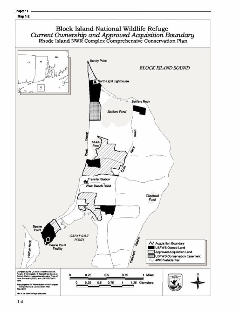
Originally established as Pettaquamscutt Cove National WildlifeRefuge, John H. Chafee National Wildlife Refuge (Chafee Refuge) isthe newest addition to the Refuge Complex. The refuge is located inthe Towns of South Kingstown and Narragansett, WashingtonCounty, RI, and centered in the community of Middlebridge (seemaps 1-1 and 1-2). The refuge is mainly surrounded by private land.Most of its parcels border the Narrow River, a navigable publicwaterway.
In 1988, Senator John H. Chafee proposed legislation designating600 acres of Pettaquamscutt Cove and its associated uplands for theprotection of black ducks, shorebirds, and other waterfowl. In 1996,another bill revised the refuge acquisition boundary to include the128-acre “Foddering Farm Acres,” purchased in 1997. In 1999,Congress recognized Senator John H. Chafee’s significantcontributions to natural resource protection by renamingPettaquamscutt Cove Refuge the “John H. Chafee at PettaquamscuttCove National Wildlfie Refuge”. The 2002 Land Protection Plan(Appendix E) expanded the acquisition boundary by 878 acres. Therefuge currently owns 329 acres within a 1,342-acre refugeacquisition boundary.
The Purpose of and Need for a CCP
Developing a CCP is vital to refuge management. The purpose ofthe CCP is to provide strategic management direction over the next15 years, by…
■ Providing a clear statement of desired future conditions forhabitat, wildlife, visitor services, and facilities;
■ Providing refuge neighbors, visitors, and partners with a clearunderstanding of the reasons for management actions;
■ Ensuring refuge management reflects the policies and goals of theRefuge System and legal mandates;
■ Ensuring the compatibility of current and future public use;
■ Providing long-term continuity and direction for refugemanagement; and
■ Providing direction for staffing, operations, maintenance, anddeveloping budget requests.
Chapter 1
Rhode Island National Wildlife Refuge Complex1-2

Chapter 1

Chapter 1
Chafee Refuge CCP – May, 2002 1-5
The need to develop a CCP for Chafee Refuge is two-fold. First, the1997 National Wildlife Refuge System Improvement Act (RefugeImprovement Act) requires that all national wildlife refuges have aCCP in place by 2012 to help fulfill the mission of the RefugeSystem. Second, the refuge lacks a master plan that establishespriorities and ensures consistent, integrated management among thefive refuges in the Rhode Island Refuge Complex.
The U.S. Fish and Wildlife Service and its Mission
The Service, part of the Department of the Interior, managesnational wildlife refuges and national fish hatcheries. By law,Congress entrusts the following federal trust resources to theService for conservation and protection: migratory birds and fish,endangered species, inter-jurisdictional fish, wetlands, and certainmarine mammals. The Service also enforces federal wildlife lawsand international treaties on importing and exporting wildlife, assistswith state fish and wildlife programs, and helps other countriesdevelop wildlife conservation programs.
The National Wildlife Refuge System and its Mission
The Refuge System is the world’s largest collection of lands andwaters set aside specifically for conserving wildlife and protectingecosystems. More than 525 national wildlife refuges, in every stateand a number of U.S. Territories, protect more than 93 million acres.More than 34 million visitors annually hunt, fish, observe andphotograph wildlife, or participate in environmental education andinterpretive activities on refuges.
In 1997, Congress passed the National Wildlife Refuge SystemImprovement Act, establishing a unifying mission for the RefugeSystem, and a new process for determining compatible public useactivities on refuges. It also requires that we prepare a CCP foreach refuge. The act states that, first and foremost, the RefugeSystem must focus on wildlife conservation. It further states thatthe mission of the Refuge System, coupled with the purpose(s) forwhich each refuge was established, will provide the foundation formanagement direction for each refuge.
On public use, the act declares that all existing or proposed publicuses must be compatible with each refuge’s purpose. It highlights sixwildlife-dependent public uses as priorities that all CCPs mustevaluate: environmental education and interpretation, fishing,hunting, and wildlife observation and photography. Each refugemanager determines the compatibility of an activity by evaluating itspotential impact on refuge resources, insuring that the activitysupports the Refuge System mission, and ensuring that the activitydoes not materially detract from or interfere with the refuge purpose.
“...working with others, toconserve, protect andenhance fish wildlife, andplants and their habitatsfor the continuing benefitof the American people.”
– Mission, U.S. Fish &Wildlife Service
“...to administer anational network of landsand waters for the conservation, management, and whereappropriate, restorationof the fish, wildlife, andplant resources and their habitats within theUnited States for the benefit of present andfuture generations ofAmericans.”
– Refuge System Mission,Refuge Improvement Act;
Public Law 105-57
Chapter 1
Rhode Island National Wildlife Refuge Complex1-6
Refuge Purpose
The establishment purposes for Chafee Refuge are:
(1) To protect and enhance the populations of black duck and otherwaterfowl, geese, shorebirds, terns, wading birds, and otherwildlife using the refuge;
(2) To provide for the conservation and management of fish andwildlife within the refuge;
(3) To fulfill international treaty obligations of the U.S. respectingfish and wildlife;
(4) To provide opportunities for scientific research, environmentaleducation, and wildlife-oriented recreation.
– 102 Stat. 3177, Nov. 5, 1988 (Public Law 100-610)
National and Regional Mandates Guiding this CCP
This section highlights Service policy, legal mandates, and existingresource plans, arranged from the national to the local level, thatdirectly influenced development of this CCP.
The Digest of Federal Resource Laws of Interest to the USFWS lists thevarious federal laws, Executive Orders, treaties, interstate compacts,and regulations on conserving and protecting natural and culturalresources (online at http://laws.fws.gov/lawsdigest/indx.html). TheService Manual and Refuge Manual contain Service policies andguidance on planning and day-to-day refuge management. The draftCCP/EA was written to fulfill compliance with NationalEnvironmental Policy Act of 1969 (NEPA)
North American Waterfowl Management Plan (May 14, 1986)
This plan outlines the strategy among the United States, Canada,and Mexico to restore waterfowl populations by protecting,restoring, and enhancing habitat within 11 U.S. Joint VentureRegional Areas and three species Joint Ventures: Arctic Goose,Black Duck, and Sea Duck. Partnerships among federal, state andprovincial governments, tribal nations, local businesses, conservationorganizations, and individual citizens protect that habitat. TheRefuge Complex lies within the Atlantic Coast Joint Venture, whichhas identified 13 priority focus areas totaling 3,226 acres of bothwetlands and adjacent uplands for protection in Rhode Island(Atlantic Coast Joint Venture 1988). Three priority focus areas in theRefuge Complex are Trustom Pond, Ninigret Pond, and thePettaquamscutt (Narrow) River.
Since black ducks winter in Rhode Island, the goals and objectives ofthe Black Duck Joint Venture apply to managing the RefugeComplex. The Black Duck Joint Venture has identified the coastalsalt marsh habitats along the mid-upper Atlantic coast as veryimportant wintering habitat.
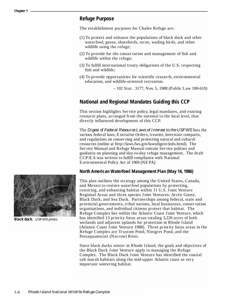
Black duck. USFWS photo.

Partners In Flight Landbird Conservation Plan: Physiographic Area 9, Southern New England (draft, October 2000)
In 1990, Partners in Flight (PIF) was conceived as a voluntary,international coalition of government agencies, conservationorganizations, academic institutions, private industry, and othercitizens dedicated to reversing the downward trends of decliningspecies and “keeping common birds common.” The foundation ofPIF’s long-term strategy for bird conservation is a series ofscientifically based Landbird Conservation Plans. The goal of eachPIF Landbird Conservation Plan is to ensure long term maintenanceof healthy populations of native landbirds.
The Partners in Flight Program is developing a plan for theSouthern New England Physiographic Area, using existing data onhabitat loss, landbird population trends, and the vulnerability ofspecies and habitats to threats, to rank the conservation priority oflandbird species. The plan will identify focal species for each habitattype from which population and habitat objectives and conservationactions will be determined. We utilized this draft document for thelist of priority species to consider in management. A revised draft ofthe plan was released in October 2000, and we will use the final plan,when finished, to further guide management.
Connecticut River/Long Island Sound Ecosystem Priorities, 1997
During the last decade, we have emphasized ecosystem conservation,particularly the role of refuges within ecosystems, and their ability toaffect the long-term conservation of natural resources. Implementingan ecosystem approach to resource management is one of our topnational priorities. We have initiated new partnerships with privatelandowners, state and federal agencies, corporations, conservationgroups, and volunteers, to form 52 ecosystem teams across thecountry, typically using large river watersheds to define ecosystems.Those teams work on developing goals and priorities for research andmanagement within each ecosystem.
The Refuge Complex lies within our Connecticut River/Long IslandSound Ecosystem (Map 1-3). A team composed of Fish and WildlifeService personnel and representatives from six State Fish and WildlifeDepartments developed a Priority Resources Plan (July 1996) thatidentifies seven priorities, each involving numerous action strategies.
1. Protect, restore, and enhance listed and candidatepopulations…with special emphasis on beach strand species,coastal sandplain habitat, and Connecticut River species.
2. Protect, restore, and enhance anadromous and interjurisdictionalmigratory fish populations…with special emphasis on Atlanticsalmon, American shad, shortnose sturgeon, and river herring.
3. Reverse the decline of migrant landbirds…with special emphasison grassland and forest interior species.
4. Protect, restore, and enhance populations of colonial nestingwaterbirds, shorebirds, and waterfowl…with special emphasis oncoastal areas and major rivers.
5. Protect, restore, and enhance wetland habitats.
Chapter 1
Chafee Refuge CCP – May, 2002 1-7

Rhode Island National Wildlife Refuge Complex1-8

6. Manage refuge lands to protect, restore, and enhance nativecommunities and trust resources.
7. Develop a public that values the fish and wildliferesources…understands events and issues related to theseresources, and acts to promote fish and wildlife conservation.
Regional Wetlands Concept Plan – Emergency Wetlands ResourcesAct 9 (USFWS 1990)
In 1986, Congress enacted the Emergency Wetlands Resources Act topromote the conservation of our nation’s wetlands. The Act directedthe Department of Interior to develop a National Wetlands PriorityConservation Plan identifying the location and types of wetlands thatshould receive priority for acquisition by federal and state agenciesusing Land and Water Conservation Fund appropriations. In 1990,the Service’s Northeast Region completed a Regional WetlandsConcept Plan identifying a total of 850 wetland sites in the Regionwarranting consideration for acquisition due to wetland values.Wetland values, functions, and potential threats for each site werecited; 24 sites within the State of Rhode Island were listed.
Protecting Our Land Resources: A Land Acquisition and Protection Plan, Rhode Island Departmentof Environmental Management, May 1996
The purpose of this State plan is to assist agencies within the RhodeIsland Department of Environmental Management (RI DEM) inprotecting land to support their primary mission, “…protection ofthe integrity of natural resources essential to the environmental,economic and social welfare of the citizens of Rhode Island.” Itsframework provides strategies to permanently protect five criticalState resources: agriculture, forestry, drinking water, recreation, andnatural heritage and biodiversity. It includes evaluation criteria forselecting and prioritizing lands.
Special Area Management Plan – Narrow River, November 1998
This plan details management strategies for implementing theprogram standards of the State of Rhode Island Coastal ResourcesManagement Council (CRMC) in the Narrow River Watershed. TheNarrow River SAMP defines these objectives relevant to our CCP:
1. Provide for a balance of compatible uses, consistent with theCRMC responsibility for preserving, protecting, and restoringcoastal resources.
2. Provide a regional plan for the Narrow River that recognizes thatthe watershed functions as an ecosystem.
3. Identify ways nitrogen can be reduced in the watershed throughnew technologies.
4. Revise and update existing policies and standards as well asrecommendations to municipalities and federal and state agencies.
5. Update all maps using the Rhode Island Geographic InformationSystem, and modify SAMP boundaries as needed to manage forerosion and water quality pollution.
6. Identify and prioritize future research agendas for the region.
Chapter 1
Chafee Refuge CCP – May, 2002 1-9

Chapter 1
Rhode Island National Wildlife Refuge Complex1-10
Existing partnerships
Throughout this CCP, we use the term “partners”. In addition to ourvolunteers, we receive significant help from the following partners:
■ Southern New England/New York Bight Coastal EcosystemsOffice (FWS)
■ Ecological Services, New England Field Office (FWS)
■ Friends of the National Wildlife Refuges of Rhode Island
■ Rhode Island Department of Environmental Management (RI DEM)
■ The Nature Conservancy, Rhode Island and Block Island Offices
■ University of Rhode Island, Department of Natural ResourcesScience (URI)
■ Audubon Society of Rhode Island
■ Rhode Island Coastal Resources Management Council (RI CRMC)
■ Local land trusts
■ Narragansett Indian Tribal Council

Chafee Refuge CCP – May 2002 2-1
Public Open House presenting CCP, Rhode IslandUSFWS photo
■ The Comprehensive Conservation Planning Process■ Issues, Concerns, and Opportunities
Chapter 2
Planning Process
The Comprehensive Conservation Planning Process
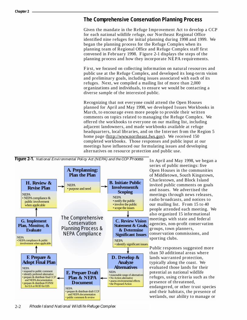
Given the mandate in the Refuge Improvement Act to develop a CCPfor each national wildlife refuge, our Northeast Regional Officeidentified nine refuges for initial planning during 1998 and 1999. Webegan the planning process for the Refuge Complex when itsplanning team of Regional Office and Refuge Complex staff firstconvened in February 1998. Figure 2-1 displays the steps of theplanning process and how they incorporate NEPA requirements.
First, we focused on collecting information on natural resources andpublic use at the Refuge Complex, and developed its long-term visionand preliminary goals, including issues associated with each of itsrefuges. Next, we compiled a mailing list of more than 2,000organizations and individuals, to ensure we would be contacting adiverse sample of the interested public.
Recognizing that not everyone could attend the Open Housesplanned for April and May 1998, we developed Issues Workbooks inMarch, to encourage even more people to provide their writtencomments on topics related to managing the Refuge Complex. Weoffered the workbooks to everyone on our mailing list, includingadjacent landowners, and made workbooks available at refugeheadquarters, local libraries, and on the Internet from the Region 5home page (http://www.northeast.fws.gov). We received 150completed workbooks. Those responses and public input at ourmeetings have influenced our formulating issues and developingalternatives on resource protection and public use.
In April and May 1998, we began aseries of public meetings: fiveOpen Houses in the communitiesof Middletown, South Kingstown,Charlestown, and Block Islandinvited public comments on goalsand issues. We advertised themeetings through news releases,radio broadcasts, and notices toour mailing list. From 15 to 40people attended each meeting. Wealso organized 15 informationalmeetings with state and federalagencies, non-profit conservationgroups, town planners,conservation commissions, andsporting clubs.
Public responses suggested morethan 50 additional areas wherelands warranted protection,typically along the coast. Weevaluated those lands for theirpotential as national wildliferefuges, using criteria such as thepresence of threatened,endangered, or other trust speciesand their habitats, the presence ofwetlands, our ability to manage or
Chapter 2
Rhode Island National Wildlife Refuge Complex2-2
A. Preplanning:Plan the Plan
E. Prepare Draft Plan & NEPA
Document
NEPA• purpose and need
NEPA• prepare & distribute draft CCP
and NEPA documentation• public comment & review
H. Review & Revise Plan
NEPA• NEPA compliance &
public involvement when applicable
NEPA• notify the public• involve the public• scope the issues
B. Initiate Public Involvement&
Scoping
NEPA• NEPA compliance & public
involvement when applicable
C. Review Vision Statement & Goals,
& Determine Significant Issues
NEPA• identify significant issues
F. Prepare & Adopt Final PlanNEPA• respond to public comment• identify preferred alternative• prepare & distribute final CCP
and NEPA documentation• prepare & distribute FONSI
for EA or ROD for EIS
NEPA• reasonable range of alternatives• No Action alternative• assess environmental effects• the Proposed Action
D. Develop & Analyze
Alternatives
G. Implement Plan, Monitor, &
Evaluate
The Comprehensive Conservation
Planning Process & NEPA Compliance
Figure 2-1. National Environmental Policy Act (NEPA) and the CCP Process
restore the areas, existing threats to their integrity, and their sizeand location.
We distributed a Planning Update to everyone on our mailing list inSeptember 1998. This newsletter summarized public comments frommeetings and workbooks, described policy guidelines for managingpublic use on refuges, and identified the long-term vision and goalsfor the Refuge Complex.
Once the key issues had firmed up, we developed alternativestrategies by May 1999 to resolve each one. We derived thestrategies from public comment, from follow-up contacts withpartners, or from the planning team. We distributed a secondPlanning Update newsletter in May 1999, updating everyone on ourplanning timelines and our decision to start a separateEnvironmental Assessment for the visitor center/headquarters.
We released a draft CCP/EA in December of 2000 for a 51-daycomment period. We held public hearings and open houses inFebruary of 2001. A summary of public comments and our responseto them is included in Appendix B. The land acquisition component ofthe process is in the Land Protection Plan, Appendix E.
Each year, we will evaluate our accomplishments under this CCP,including the completion of more detailed step down plans.Monitoring or new information results may indicate the need tochange our strategies. We will modify the CCP documents andassociated management activities as needed, following theprocedures outlined in Service policy and NEPA requirements. ThisCCP will be fully revised every 15 years, or sooner if necessary.
Issues, Concerns, and Opportunities
From the Issues Workbooks, public and focus group meetings, andplanning team discussions, we developed for each refuge a list ofissues, concerns, opportunities, or any other items requiring amanagement decision. Then we sorted them into two categories:“Key issues,” and “Issues and concerns considered outside the scopeof this analysis”.
Key issues, along with the goals, formed the basis for developing andcomparing the draft CCP/EA alternatives. Issues outside the scopeof our analysis were described in the draft CCP/EA, but will not beaddressed further in this final CCP.
Key Issues
Public and partner meetings and further team discussions producedthe key issues briefly described below.
1. Protection of endangered and threatened species and otherspecies and habitats of special concern.
This is the most important issue facing the refuge. Protectingfederally listed endangered and threatened species is integral to themission of the Refuge System. Other federal trust species are also ofprimary concern, including migratory birds, anadromous fish, andcertain marine mammals.
Chapter 2
Chafee Refuge CCP – May 2002 2-3

Appendix A lists species and habitats of special managementconcern. The list includes the status of all plants, wildlife, fish, andrare natural communities known to occur in Rhode Island that arefederally listed as endangered or threatened, were candidates forlisting, or are otherwise of management concern. Combined withlocation information, we used that list to identify additional landprotection needs and opportunities. We know very little about manyof these species’ presence on or use of refuge habitats. Thealternatives in the draft CCP/EA differed in their strategies formanaging these species and habitats. Addressing this issue will helpachieve Goal 1: Protect and enhance federal trust resources andother species and habitats of special concern.
2. Restoration and maintenance of coastal sandplain naturalcommunities, including grasslands and shrublands (less than60 years old).
While it is true that the Northeast landscape was primarily forestedprior to rapid agricultural settlement in the 1800’s, grasslands quicklybecame a dominant part of the landscape in the 19th century.Grassland-dependent species responded in kind and became established.Over the last several decades, however, coastal sandplain grasslands andshrublands, coastal maritime grasslands and shrublands, andagricultural fields and pastures, have been in rapid decline in NewEngland due to a combination of development, changes in agriculturaltechnology, succession to forest as farms were abandoned, and lack of anatural disturbance such as fire (Vickery 1997).
In Rhode Island, the State’s farmland dropped nearly 50 percentbetween 1964 and 1997, from 103,801 to 55,256 acres. An additional3,100 acres of farmland will be lost in the next 20 years if currentsprawl patterns continue (Common Ground 2000). As a result, fewlarge, contiguous grasslands and shrublands are left; only smaller,fragmented, and isolated habitat patches remain (<75 acres).
These smaller areas are unsuitable for many focus species, includingonce-common grassland birds such as grasshopper sparrow andupland sandpiper. Grasshopper sparrows have declined by 69percent in the past 25 years, according to Breeding Bird Survey data(Vickery 1997). Our best available information suggests thatgrasslands should ideally be managed in 100 acre or larger patches.Smaller grassland habitat patches are much less productive forgrassland birds, and could serve as “sinks”, where species try tonest, but becaused of increased predation and other factors,productivity and survival is severely limited.
Other grassland and shrubland species have declined dramatically aswell. Many of Rhode Island’s State-listed plant and animal speciesare dependent on these habitat types.
Tremendous potential exists for refuge staff to become involved inrestoring habitat on private lands. Grassland and shrublandrestoration offers opportunities for our staff to provide technicalexpertise to local communities. The alternatives in the draft CCP/EAcompared different levels of restoring and maintaining these habitatsand providing technical assistance to private landowners. Addressingthis issue will help achieve Goal 2: Maintain and/or restore naturalecological communities to promote healthy, functioning ecosystems.
Chapter 2
Rhode Island National Wildlife Refuge Complex2-4

3. Protection and restoration of wetlands.
The well documented values of healthy wetlands include fish andwildlife habitat, flood protection, erosion control, and water qualitymaintenance. Despite laws and regulations to protect them,wetlands throughout Rhode Island have been rapidly declining sincethe 1960’s through conversion to agriculture, residential andindustrial development. Rhode Island has developed more land inthe last 34 years than in its first 325 years (Common GroundMay/June 2000). Most recent sprawl occurs outside the urban areas,near the remaining wetlands.
Estuarine wetlands consisting of tidal salt and brackish waters are ofparticular concern. Invasive species are dominating refuge wetlandsand threatening their biodiversity.
Non-point pollution and sources off-refuge are impacting waterquality and the health and productivity of these wetlands. Thealternatives in the draft CCP/EA compared different levels ofmanagement for restoring wetlands and for cooperatively managingentire watersheds. Addressing this issue will help achieve Goal 2:Maintain and/or restore natural ecological communities to promotehealthy, functioning ecosystems.
4. Maintenance of water quality in the Narrow River.
The Narrow River provides many values beneficial to a diverse arrayof wildlife and to the surrounding communities. Many wildlifespecies use the estuary and adjacent wetlands as a primary foodsource, a migratory rest stop, and as breeding, nesting, andspawning grounds.
The quality of both groundwater and surface water continues todeteriorate as a result of residential and commercial developmentwithin the watershed and the associated contribution of non-pointpollutants such as individual septic systems. Since 1959, the NarrowRiver has failed to meet State standards for coliform bacteria, andparts of the river have been closed to shell fishing since 1979. Itsdegraded water quality threatens wetland habitats in Chafee Refuge,constraining their ability to fulfill the refuge purpose. The alternativesin the draft CCP/EA evaluated different levels of involvement incooperatively managing and protecting the watershed. Addressingthis issue will help achieve Goal 2: Maintain and/or restore naturalecological communities to promote healthy, functioning ecosystems.
5. Control of invasive, non-native, or overabundant plant andwildlife species.
Each of the five refuges has an extensive distribution of invasiveplant species. These plants are a threat because they displace nativeplant and animal species, degrade wetlands and other naturalcommunities, and reduce natural diversity and wildlife habitatvalues. They outcompete native species by dominating light, water,and nutrient resources. Once established, getting rid of invasiveplants is expensive and labor-intensive. Unfortunately, theircharacteristic abilities to establish easily, reproduce prolifically, anddisperse readily, make eradication difficult.
Chapter 2
Chafee Refuge CCP – May 2002 2-5

Many of these plants cause measurable economic impacts, particularlyin agricultural fields. Preventing new invasions is extremelyimportant for maintaining biodiversity and native plant populations.The control of existing, affected areas will require extensivepartnerships with adjacent landowners, state, and local governments.
Thirteen invasive plant species affecting the natural communitieswithin the Refuge Complex are considered of high managementconcern. The most prevalent are Phragmites, purple loosestrife,Asian bittersweet, autumn olive, and Japanese honeysuckle. Otherspecies such as Japanese knotweed and multiflora rose are increasingon the Refuge Complex, and likely to become an issue soon.
Several wildlife species occur on the Refuge Complex that are known,or suspected to be, adversely affecting natural diversity. Issuessurface when these species directly impact federal trust species ordegrade natural communities. Mute swans are non-native, invasivespecies that aggressively drive native waterfowl and shorebirds awayfrom nesting areas, compete with them for food, degrade waterquality when they spend extended periods of time molting on coastalponds, and are sometimes aggressive towards humans.
Native species such as deer, red fox, gull, and small predatorymammals such as mink, skunk, and weasel can be a problem whentheir populations exceed the range of natural fluctuation and theability of the habitat to support them. Excessive numbers of deer area threat to rare plant communities on the Refuge Complex, andexcessive browse lines are evident on two refuges. Adjacentlandowners are also concerned about deer impacts on landscaping,the increase in vehicle-deer collisions, and the threat of Lyme disease.
Red fox, gull, and some small mammals are voracious predators thatcan adversely impact other native wildlife populations. Occurrenceshave been documented of herring and black-backed gull, red fox, andweasel preying on piping plover and least tern, a State-listed species(threatened). Fox easily habituate to humans, and were being hand-fed at Sachuest Point Refuge. Many people fear fox and othermammals because they can carry rabies. These predators areparticularly troublesome when their populations exceed naturallevels. Control measures for each species are controversial, and mayinclude lethal removal, visual and audio deterrents, or destroyingeggs, nests, or den sites.
The alternatives in the draft CCP/EA compared different strategiesfor managing invasive species. Addressing this issue will helpachieve Goal 1: Protect and enhance Federal trust resources andother species and habitats of special concern, and Goal 2: Maintainand/or restore natural ecological communities to promote healthy,functioning ecosystems.
6. Protection of biologically significant areas throughacquisition and/or cooperative management.
Public meetings, partner meetings, and workbook responsesexpressed a great deal of support for the protection of additional fishand wildlife habitat in southern Rhode Island. That support runsacross the State, as Rhode Islanders consistently vote ballot measures
Chapter 2
Rhode Island National Wildlife Refuge Complex2-6
to maintain open space and protect fish and wildlife habitats. Manypeople mentioned that their support stems from their concern over therapid pace of development on the South Shore. As we stated earlier,development in non-urban areas of Rhode Island has increaseddramatically over the last 30 years. It is now the second most denselypopulated State in the country. One estimate predicts that currentsprawl patterns will ensure the loss of all its rural areas before 2100(Common Ground 2000). The Rhode Island office of The NatureConservancy has noted that the conservation actions taken during thenext 5 to 10 years will be the most important for the majority of RhodeIsland towns (The Nature Conservancy 2000).
This dramatic increase in development has changed land use patternsand practices, significantly modifying natural landscapes. As naturallands (those with sustainable native species populations and intactecological processes) become isolated and fragmented into smallerpieces disconnected from other natural areas, their ability to supporta full complement of native species is adversely affected. Cut off fromlarger populations, species and plant communities within thesenatural areas face the problems of limited genetic exchange, adecreased ability to support diverse populations, and lost capacity torecruit new individuals. Ultimately, the number of native speciesdeclines and exotic species gain a stronghold. It is precisely thisdiminished ability of natural areas to support diverse species withdifferent habitat requirements that leads to a decline in biodiversity.While some species can tolerate fragmentation as they prefer “edgehabitat,” many others, including “interior” dependent species, requirelarger, contiguous natural areas or functional corridors linkingpatches of natural habitat. This ability to protect and sustain largernatural areas and corridors, coupled with the protection of unique orrare species or communities, is critical to maintaining biodiversity.
A landscape or ecosystem approach to protecting land is also criticalin the recovery of threatened and endangered species. Piping ploverserve to illustrate this point. They have a fairly strong fidelity tocertain nesting areas and typically return to them most years.Shifting of pairs between nesting areas has been observed whendisturbances or habitat conditions affect their ability to nest. Barrierbeaches are dynamic ecosystems, and their nesting conditions canchange dramatically from year to year. While 1999 was a goodnesting year on Moonstone Beach (Trustom Pond Refuge), in 2000,the beach consisted entirely of cobble with virtually no sand fornesting. The piping plover pairs from 1999 appeared to have shiftedto the Ninigret Conservation Area. Without consideration of theseshifts in habitat use across a landscape, management for thesespecies would be ineffective.
Some individuals preferred that the Service acquire and managefederal trust resources, and that the Refuge Complex continue toacquire these sites. Others emphasized partnerships tocooperatively protect and manage important habitats not currentlyon refuge land. Still others recommended a combination of Serviceacquisition and cooperative management to provide the greatestlong-term benefit to resources. At public meetings and in ourworkbooks, many responses suggested specific areas needingprotection, particularly wetlands threatened by development. Someindividuals we spoke with especially supported our acquiring landoccupied by endangered or threatened species.
Chapter 2
Chafee Refuge CCP – May 2002 2-7

The alternatives in the draft CCP/EA offered various levels ofService land acquisition, ranging from lands within the currentlyapproved acquisition boundaries only, to a considerable expansion ofeach refuge’s acquisition boundary. They also evaluated ourincreased involvement in cooperative land protection off-refuge.Addressing this issue will help achieve Goal 3: Establish a landprotection program that fully supports accomplishment of species,habitat, and ecosystem goals.
7. Assurance of access to credible information about resourcesregarding the Refuge Complex to ensure managementdecisions are based on the best available science.
We need to determine and prioritize what information reasonablycould be collected to facilitate decision-making using the bestavailable science. In particular, many individuals expressed concernover the lack of information available to fully evaluate impacts towildlife and habitats from excessive public use. Others questionedthe effectiveness of management actions that have not beenadequately monitored and evaluated. Several university researchersand other partners encouraged our staff to prioritize baselineinventory needs, establish monitoring protocols to better evaluatemanagement actions, and identify information needed to determineeach refuge’s contribution to the ecosystem.
Implementing the Service’s Policy on Maintaining the BiologicalIntegrity, Diversity, and Environmental Health of the NationalWildlife Refuge System will require us to ascertain the naturalconditions for each refuge and identify the natural communities,species, and ecological processes that are rare, declining, or unique.Opportunities to cooperate in collecting this information could bedeveloped once the priorities have been identified. The alternativesin the draft CCP/EA offered different levels of pursuing thisinformation. Addressing this issue will help achieve all the Goalsidentified for the Refuge Complex.
8. Management of public use and access.
The Refuge Improvement Act and Service policy require ourenhanced consideration of opportunities for six priority wildlife-dependent uses (see above). Some level of each occurs on the RefugeComplex. Only those uses that are compatible with a refuge’spurpose may be allowed. According to Service policy, all refuges areclosed to any use until it is formally opened through the compatibilitydetermination process.
The act also directs refuges to terminate immediately or phase out asexpeditiously as practicable, existing uses determined to be notcompatible. Non-wildlife-dependent uses exist on all the refuges, andsome have been occurring for years. Examples include jogging,sunbathing and swimming, bicycling, and dog walking.Input from public meetings and workbook responses make it clearthat public use on refuges is extremely important to most people.More than 90 percent ranked environmental education andinterpretation and wildlife observation and photography very high asdesirable public uses. Rarely, however, was there consensus on otherpublic uses or just how much of each type to allow. Public opinion
Chapter 2
Rhode Island National Wildlife Refuge Complex2-8

spans the entire spectrum from those wanting to open up refuges tonon-wildlife-dependent activities, to those who want to close refugesto all public use to maintain an undisturbed sanctuary for wildlife.
The alternatives in the draft CCP/EA compared different levels andcombinations of wildlife-dependent public use. Addressing this issuewill help achieve Goal 4: Provide opportunities for high quality,compatible, wildlife-dependent public use with particular emphasison environmental education and interpretation.
9. Hunting.
Hunting surfaced late in the scoping process as a key issue, perhapsbecause, initially, few viewed it as a possibility on the RefugeComplex. This issue was raised by Service personnel, by RI DEMbiologists, and by individuals both for and against expanding huntingopportunities on the Refuge Complex. Those in support primarilyare interested in deer hunting on all refuges, waterfowl hunting onChafee Refuge and Ninigret Refuge, and pheasant hunting on BlockIsland. Advocates of hunting refer to its inclusion as one of the sixpriority public uses that “...shall receive priority consideration inrefuge planning and management” (1997 Refuge Improvement Act).
The Service views managed or administrative hunts in areas wherethere are overabundant deer populations as an effective tool forregulating them. Responses generally agree that the overabundanceof deer is a concern in Rhode Island, reflected in increased numbers ofvehicle-deer collisions, increased complaints about deer browsing oncommercial and residential landscape plantings, visible impacts onnative vegetation, and higher concern about contracting Lyme disease.
Those opposed to hunting cited concerns with public safety,disturbance and harm to other wildlife species, and the impact tovisitors engaged in the other five priority public uses. The latterresults from the likelihood that significant portions of the refuges,due to their small sizes and configurations, would be closed to otheractivities during hunting. Some expressed the opinion that therefuges should function as a sanctuary for all native species, and thathunting is incongruous with that function.
The alternatives in the draft CCP/EA offered varying levels ofhunting opportunities, from no hunting at all, to opening four refugesduring State-regulated seasons for deer, waterfowl, and pheasant.Addressing this issue will help achieve both Goal 2: Maintain and/orrestore natural ecological communities to promote healthy,functioning ecosystems, and Goal 4: Provide opportunities for highquality, compatible, wildlife-dependent public use with particularemphasis on environmental education and interpretation.
10. Opportunities for environmental education.
Responses so frequently mentioned increasing environmentaleducational opportunities across the Refuge Complex that ourplanning team decided it warranted special recognition. More than 90percent of the workbook responses ranked environmental education
Chapter 2
Chafee Refuge CCP – May 2002 2-9
and interpretation as one of their top three interests. The alternatives in thedraft CCP/EA compared different levels of environmental educationalopportunities and the different levels of partnerships so integral toimplementing them on each of the five refuges. Addressing this issue will helpachieve Goal 4: Provide opportunities for high quality, compatible, wildlife-dependent public use with particular emphasis on environmental education andinterpretation.
11. Provision of staffing, operations, and maintenance supportsufficient to accomplish goals and objectives.
The Refuge Complex lacks adequate funding and personnel to provide theprograms and services desired by the public and to effectively meet the goalsfor this CCP. The alternatives in the draft CCP/EA compared differentfunding and staffing levels based on their proposed management strategies fordealing with the issues. Addressing this issue will help achieve Goal 5: ProvideRefuge Complex staffing, operations, and maintenance support to effectivelyaccomplish refuge goals and objectives.
12. Increasing the visibility of the Fish and Wildlife Service.
Our lack of visibility on refuges was brought up repeatedly at public meetingsand in the workbooks. Many people felt strongly about the need for morerefuge staff to be present during peak visitation to increase resourceprotection and improve visitor services. Other recommendations to increasevisibility included more visitor contact stations, increasing wildlifeinterpretation and environmental educational opportunities, a better locationfor a headquarters office, developing a Refuge Complex visitor center,improving existing visitor facilities (e.g., kiosks, interpretive signs on trails,etc.), increasing support for a volunteer program, and increasing communityinvolvement.
Some people expressed an interest in seeing refuge staff enforce public usepolicy more consistently. Others argued it was unnecessary for Servicepersonnel to be armed while patrolling beaches. The alternatives in the draftCCP/EA compared different levels of promoting our visibility and providingthese services. Addressing this issue will help achieve both Goal 2: Maintainand/or restore natural ecological communities to promote healthy, functioningecosystems, and Goal 4: Provide opportunities for high quality, compatible,wildlife-dependent public use with particular emphasis on environmentaleducation and interpretation.
13. Need for improved facilities.
The Refuge Complex lacks a facilities plan establishing current and future needsfor staff operations and visitor services. Many of its current facilities areinadequate. Its headquarters does not have enough office space to accommodateeven current staff, and the visitor services area is limited to one rack ofliterature in the reception area. The alternatives in the draft CCP/EA comparedopportunities for new or improved facilities to accommodate staff work space,increase the visibility of the Service and the Refuge Complex, and improvevisitor services, including environmental education and interpretation.Addressing this issue will help achieve Goal 5: Provide Refuge Complex staffing,operations, and maintenance support to effectively accomplish refuge goals andobjectives.
Chapter 2
Rhode Island National Wildlife Refuge Complex2-10

Chafee Refuge CCP – May 2002 3-1
Piping ploverUSFWS photo
■ Geographic/Ecosystem Setting■ Socioeconomic Setting■ Refuge Complex Administration■ Refuge Resources■ Cultural Resources■ Public Uses
Chapter 3
Refuge and ResourceDescriptions

Geographic/Ecosystem Setting
Landscape Formation
The movement of glaciers across New England created the landforms seen in Rhode Island today. The last of those great ice sheetsoccurred during the Wisconsin glacial period. Approximately 15,000- 20,000 years ago, the glacier was in a state of equilibrium, wherethe melting rate of ice equaled the glacial rate of movement (Bell1985). As the climate warmed 12,000 - 15,000 years ago, the glacierbegan its retreat, depositing pronounced land forms along itsoutermost edge. The southern coast of Rhode Island, includingBlock Island, is the farthest point the Wisconsin glacier reached inits southeastern frontal movement. The retreating glacier depositedrocks pushed by the front of its ice sheet in piles called moraines.These terminal or end moraines formed sinuous ridges up to 200 feethigh. Block Island is part of the terminal moraine that includesNantucket and parts of Long Island.
A second prominent moraine lies inland, the low ridge referred to asthe Charlestown or Watch Hill moraine, stretching east to west parallelto U.S. Route 1. Glacial action also created other features in today’slandscape: recessional moraines, outwash plains, kettle hole ponds,glacial lake deposits, deltas, and submerged gravel shoals. Prominentheadlands like Sachuest Point are composed of glacial till, a mixture ofsilt-sized grains to boulder-sized deposits by the melting glacier.
Melting ice sheets caused the sea to rise rapidly across Block Islandand Rhode Island Sounds until it reached its present levelapproximately 4,000 years ago. Wave action parallel to the shorecontinued to erode glacial deposits, creating the barrier spits. As thespits formed, they almost entirely sealed off the low-lying areasbetween the headlands and the ocean, forming coastal lagoonsconnected to the sea by narrow inlets. These became the coastal saltponds we see today. Through the 1700’s, all of the coastal salt pondshad direct, seasonally open connections to the ocean (RI CRMC1984). The effects of erosion through time have shifted the saltponds and barrier spits gradually landward (RI CRMC 1998).
The bedrock formations of southern Rhode Island include theBlackstone series of metamorphic rock along its southern coastalborder (including most of Westerly, Charlestown and SouthKingstown), granite rock of various ages (including most ofNarragansett and Middletown and parts of Westerly andCharlestown), and Pennsylvanian sedimentary rock in most of southcentral Rhode Island (including Richmond, much of SouthKingstown, and most of Hopkinton). Most of the soils around therefuges are fine sandy loams or silt loams.
Historical Influences on Landscape Vegetation
The upland forests of southern Rhode Island are classified byKuchler (1964) as oak-hickory forest; while most of northern RhodeIsland is classified as oak-pitch pine forest. Historic land usepractices promoted this forest type.
As early as 12,000 years ago, Native Americans began occupying thearea. Documented evidence places the first intensive occupation of
Chapter 3
Rhode Island National Wildlife Refuge Complex3-2
the salt pond region during the late Archaic period (5,000 to 3,000years ago). Native American camps from more than 4,000 years agoare known to have existed at one location along the shore of NinigretPond. However, societies of that time were primarily hunter-gatherer with little agriculture; broad changes to landscapevegetation probably did not occur.
During the Woodland Period 3000-450 years ago, larger, semi-permanent or recurrently occupied camps became coastalsettlements. Fortified villages are known to have existed in somelocations. Maize horticulture became prominent, which likelyresulted in small clearings. Larger clearings and burnings to controlthe movement of deer and upland birds may have occurred, and thefirst pronounced clearing of land along the coast for settlements,game management, and agriculture. Much of this land was clearedby cutting and burning, which favored resprouting by hardwoodspecies like oak, hickory, and red maple.
The role fire may have played in shaping landscape vegetation is notwell known. Evidence of fire has been observed in charcoal layers atNinigret Refuge. Soil cores dug at most points on the refuge revealcharcoal below the historic farmers plow zone, approximately 10inches soil depth. The dates attributed to these fires, coupled withtheir locations, suggest early Native Americans used fire extensivelyand purposefully.
Although small areas of land were cleared and more or lesspermanently settled by early Native Americans, it was Europeansettlement and expansion in the 1600’s that exponentially escalatedthe conversion of forests to agriculture. The eighteenth centuryRhode Island plantation era “…required massive land clearing of theforests that had dominated the landscapes for the last 8,000 years”(USFWS 1999). During the mid-nineteenth century, an estimated 85percent of southern New England was converted to field andpasture. Any woods remaining often were managed for firewood(Jorgensen 1977).
A detailed report on the archeological history of the RefugeComplex is available from the Refuge Complex office on request(Jacobson USFWS).
Contemporary Influences on the Landscape
The major natural disturbances affecting the coastline today arehurricanes and winter ice-storms. Hurricanes have the greatestimpact, by far. The straight border of barrier beaches separatedfrom the mainland by tidal wetlands and coastal salt pondscharacterizes a coastline influenced by frequent storms. Wind andwaves pick up loose sand and sediment and move it along theshoreline or back out to sea, allowing occasional overwash of barrierbeaches and breaching of coastal ponds. Overwash, tidal currents,longshore currents, and rip currents are all mechanisms transportingsediment along the barrier beaches (RI CRMC 1998).
Fall and winter storms combining wind, rain, and waves are thepredominant physical process shaping this landscape today.“Nor’easters” are well known along the New England coast inwinter, winds generated offshore from the southeast, can actually be
Chapter 3
Chafee Refuge CCP – May 2002 3-3

more destructive to the south shore, because of its exposure to theopen ocean. The draft Salt Pond Region Special Area ManagementPlan describes the geologic, wave, and wind action for the SouthShore, including details on how sediment movement constantlyreshapes this dynamic landscape (RI CRMC 1998).
The Great New England Hurricane of 1938 was the most recent 100-year storm, one of immense power along the coast. Not only didwinds reach speeds up to 240 miles per hour, but also a spring hightide created a storm surge between 10 and 15 feet. Storms of thismagnitude are suspected to have occurred only four other times inrecorded history: 1635, 1683, 1815, and 1821 (Bell 1985). Smallerhurricanes are less powerful but more frequent than the hurricane of1938. Hurricanes in 1944, 1954, 1955, 1960, 1976, and Hurricane Bobin 1991 each left its mark on the coastline.
Human influences on sustaining the form and function of coastallandscapes and ecosystems over the long term are predominantlynegative. Attempts to stabilize the beach system by constructingjetties or breach ways and planting beach grass have greatly affectedthe natural dynamics of this system by interrupting the natural flowof waves and sediment. In fact, the breach ways connecting theponds to the ocean and one pond to another are the single greatesthuman impact on the ecology of coastal ponds (RI CRMC 1984).
Introducing non-native, invasive plants, diverting or draining coastalwetlands for development, converting uplands for residential use,and spilling oil are other significant human impacts on the coastallandscape. Recent studies indicate that the greatest threats toRhode Island’s estuaries and coastal salt ponds are septic systemsand road runoff (RI DEM 1996). More studies are needed toestablish the extent to which each of these factors influences RefugeComplex ecosystems.
On Rhode Island’s upland landscape, a combination of managementand natural succession has allowed forests to make a comeback. TheState Division of Forest Environment estimates that 300,000 acres ofprivately owned forest plus 45,000 acres of State-managed forestmake up 45 percent of the State’s land area. Their estimate places80 percent of the privately owned forest in tracts from 1 to 10 acresin size, which are difficult to manage as forest and are rapidly beingconverted to residential areas (RI DEM 1996).
Ecosystem Delineations
The Service emphasizes an ecosystem approach to conservation,typically using large river watersheds to define ecosystems. RhodeIsland falls within our Connecticut River/Long Island SoundEcosystem (map 1-3).
Another commonly used delineation of ecosystems was developed byBailey (USDA 1978, expanded 1995). These ecologically based mapunits often are used in landscape-level analyses. An ecoregion is firstdivided into a domain, then a division, a province, a section, and asubsection. Each level defines in greater detail its geomorphology,geology, soil, climate, potential vegetation, surface water, and currenthuman use. Each of these resource attributes has implications forresource management. For example, opportunities to restore native
Chapter 3
Rhode Island National Wildlife Refuge Complex3-4

grasslands may be limited by soil types, potential vegetation, and theextent of human impacts on the natural environment. Rhode Islandfalls within the Humid Temperate Domain, Hot Continental Division,Eastern Broadleaf Forest Province, and Lower New England Section.
Climate
Cold winters and warm summers with a moderating ocean influencecharacterize Rhode Island’s climate. Winter temperatures average30º F, with lowest temperatures ranging between -10º F and -20º F.Summer temperatures average 70º F, and peak in the 90s. Annualprecipitation averages 44 to 48 inches, evenly distributedthroughout the year. Thunderstorms occur throughout the summer(USFWS 1989).
Air Quality
The Clean Air Act establishes Class I, II, and III areas with limits onthe amount of “criteria air pollutants” that can exist in pre-definedgeographic areas. Examples of criteria air pollutants are smog(primarily ground-level ozone), particulate matter, and carbonmonoxide. Class I areas allow very little additional deterioration ofair quality (e.g. Wilderness Areas); Class II areas allow for moredeterioration; and Class III areas allow even more. All of RhodeIsland is currently classified as a Class II area. The U.S.Environmental Protection Agency (EPA) has designated the entireState a serious non-attainment area for ozone. That designationresulted in stricter automobile emissions standards designed toreduce emissions by 24 percent between 1990 and 1999.
Socio-economic Factors
The Refuge Complex lies close to some of the largest populationcenters on the east coast. The New York City metropolitan area,population 8.5 million, is 2.5 hours to the southeast. MetropolitanBoston, population 3.2 million, is 2 hours to the north. Hartford, witha population of 140,000, is 1.5 hours to the northwest, andProvidence, population 161,000, is 45 minutes to the north (U.S.Census Bureau 1996 estimates and 1990 U.S. Census).
According to those estimates, the population of Rhode Island is about1 million; 94 percent live in metropolitan areas (cf. the nationalaverage of 80 percent) and 6 percent in rural areas. South County,which includes Ninigret Refuge , Trustom Pond Refuge , and ChafeeRefuge , has the fastest growing population and the highest numberof building permits issued annually (RI CRMC 1998). South Countypopulation figures between 1990 and 1996 increased 7.4 percent, 4.6percent, and 5.3 percent respectively in Charlestown, Narragansett,and South Kingstown, while Middletown’s population decreased by1.4 percent. The Town of New Shoreham, which includes BlockIsland, had a population increase of 10.8 percent. The population forthe entire state of Rhode Island decreased by 1.3 percent over thesame period (http://www.riedc.com).
The Refuge Complex directly contributes to the economies ofCharlestown, South Kingstown, Narragansett, Middletown, and NewShoreham through refuge revenue sharing payments. The FederalGovernment does not pay property tax; it does pay refuge revenue
Chapter 3
Chafee Refuge CCP – May 2002 3-5

sharing directly to cities and towns each year, based on the fairmarket value of refuge lands. The revenue sharing formula calculatesthree-quarters of 1 percent of the fair market value of refuge lands asthe maximum amount payable each year. An appraisal updated everyfive years keeps their fair market value current. The actual amountof revenue sharing paid each year varies, depending on what portionof the maximum amount Congress appropriates that year (rarely themaximum). Figure 3-1 depicts refuge revenue sharing payments tothose towns for the fiscal year 2000.
The University of Rhode Island Department of Resource Economics(Spring 1997) reports that travel and tourism is the State’s fastestgrowing industry. In 1996, it generated $1.7 billion. The number ofvisitors to the State in 1997 increased at a rate twice the nationalaverage. Also in 1997, Rhode Island’s services industry, whichincludes those in health, business, and education, comprised thelargest wage and salary employment at 34 percent (RI EDC 1997).Between 1987 and 1997, the services industry increased by 37percent, while the manufacturing industry decreased by 37 percent.
In all the communities surrounding the refuges, travel and tourismand the services that support them contribute substantially to localeconomies. According to Ann O’Neill, President of the South CountyTourism Council (O’Neill 1999), the tourist season lasts from Aprilthrough October, with peak activity during the summer months.Responses to our workbooks confirm that beaches and water-associated recreation are the primary attractions for visitors withdestinations along the Rhode Island coast.
Current travel and tourism literature does not feature the RefugeComplex. According to Ms. O’Neill, its refuges are not well known astourist destinations, although many visitors discover them during
Chapter 3
Rhode Island National Wildlife Refuge Complex3-6
Figure 3-1. Refuge Revenue Sharing Payments made to towns in 2000.
Fiscal year 2000 Refuge Revenue Sharing Paymentspaid to towns
0
5
10
15
20
25
30
Charlestown(Ninigret Refuge)
South Kingstown(Chafee & Trustom
Pond Refuges)
New Shoreham(Block Island
Refuge)
Narragansett(Chafee Refuge)
Middletown(Sachuest Point
Refuge)
Dol
lars
(tho
usan
ds)

their visit and enjoy the scenery and open space they provide. Theyare small enough to explore in one day, and generally do not promptan additional night’s lodging. Ms. O’Neill stated that, since theTourism Council is trying to showcase a greater mix of outdoorrecreational opportunities in South County, the Refuge Complex willfigure more prominently in future promotional material.
The greatest contribution by the Refuge Complex to the localeconomy comes from the values attributed to the preservation ofopen space (NPS 1992). We represent those values using threeindicators, below: Cost of Community Services; Property Values;and Public Willingness to Pay.
Cost of Community Services compares the cost per dollar of revenuegenerated by residential or commercial development to that ofrevenue generated by an open space designation. On the one hand,residential development expands the tax base, but the costs ofincreased infrastructure and public services (schools, utilities,emergency services, etc.) often offset any increase in revenue. Onthe other hand, undeveloped land requires few town services andplaces little pressure on the local infrastructure. The cost per dollarof revenue generated by commercial land typically falls betweenthose of residential and open space.
The American Farmland Trust (1989, 1992, and 1993) and theCommonwealth Research Group (1995) evaluated communityrevenues and expenses associated with open space vs. residentialand commercial development. All available information on the NewEngland States shows that open space and commercial developmentproduced more revenues than costs, while the opposite was true forresidential land.
Conversations with local realtors and appraisers helped us evaluatethe refuges’ influence on property values. Two South County realtorsand one realtor/appraiser confirmed that properties adjacent torefuges generally are valued higher (Gross, et al. 1998). That value isrealized through increased sales price/acre in properties adjacent to arefuge, compared to otherwise similar properties, and by how quicklythose properties sell. Properties with views protected by theirproximity to a refuge exhibit an even greater difference. All therealtors estimated, but none with any certainty, that propertiesadjacent to refuges may realize from 1- to 4-percent increases inproperty value. All the realtors we spoke with use a property’sadjacency to a refuge as an important advertising asset.
Public Willingness to Pay is a method for estimating the monetaryvalue of ecosystem goods and services by determining how much thepublic would be willing to pay, either in taxes, fees, or opportunitycosts, to preserve ecosystem values. In Rhode Island, where coastalecosystems are threatened by development-at-large, we have usedWillingness to Pay to estimate the value of open space preservation.
Rhode Islanders consistently and overwhelmingly vote for bondmeasures to protect open space. Local and State-wide bondmeasures passed in 1985, 1986, 1987, and 1989, invested more than$100 million in acquiring land for recreation and open space. AState-wide bond in 1998 passed an additional $15 million specificallyfor protecting open space (RI CRMC 1998).
Chapter 3
Chafee Refuge CCP – May 2002 3-7

Refuge Complex Administration
Staffing and Budget
Annual budget appropriations arehighly variable, andcommensurately affect ourstaffing levels. Table 3-1summarizes budget and staffinglevels from 1995 to 1999.Fluctuations reflect funding forspecial projects, moving costs fornew employees, or largeequipment purchases. Most of thefunding is earmarked; very littlediscretionary funding is available.
Resource Protection and Visitor Safety
Law enforcement officers, with full authority to enforce federalregulations, are required to ensure resource protection and visitorsafety. Three permanent refuge staff have been assigned collateralduties for law enforcement at any time during the course of refugeoperations, but those collateral duties draw staff time and resourcesaway from other important programs. We typically hire up to threeseasonal staff with law enforcement authority each year.
During the past 5 years, formal notices of violation averaged 15 peryear. They typically involved vehicle and pedestrian trespass,vandalism, and waterfowl hunting in closed areas. Well over 100verbal warnings are also given each year, typically for inadvertentlywalking or driving in closed areas, littering, walking dogs in a closedarea or off-leash, bicycling in closed areas, and digging plants. In1993, a Trail Warden program began using volunteers to assist indocumenting violations. Wardens also inform visitors of public usepolicy and permitted activities.
Refuge Complex Office
The Refuge Complex office lies in the Shoreline Plaza strip mall inCharlestown. In addition to housing our staff, it also houses ourDivision of Ecological Services Southern New England/New YorkBight Coastal Ecosystem Program five-member staff, an AtlanticCoast Joint Venture staff person, and Friends of the NationalWildlife Refuges of Rhode Island.
An environmental assessment was written in 2000, which determineda new location for a Refuge Headquarters and Visitor Center. Thenew building will be located on Deer Run Road (off Route 1) inCharlestown, RI. The building is currently being designed, withconstruction to begin in 2003.
Chapter 3
Rhode Island National Wildlife Refuge Complex3-8
Fiscal year
1995
1996
1997
1998
1999
Operations
$216,299
355,715
350,700
428,400
441,900
Maintenance
$85,700
23,900
97,700
171,000
28,000
Full time staff
7
7
8
8
9
Seasonal staff
3
3
4
4
2
Table 3-1. Refuge Complex staffing levels and budgets between 1995 - 1999.
Refuge Resources
Physical Resources
Topography and Hydrology
The Narrow River, which forms Pettaquamscutt Cove, has ageologically complex origin. In general, the tidal river andsurrounding uplands are remnants of an ancient river valley carvedout by glaciation approximately 10,000 years ago. Technically, theNarrow River is an estuary or a lagoon (RI CRMC 1998).
The eastern side of Chafee Refuge slopes sharply down to theNarrow River, with 15-percent (or greater) slopes along Tower HillRoad. Terrain on the eastern side slopes more gradually, averaging5 to10 percent. In Pettaquamscutt Cove, the relief is low and nearsea level. Bedrock is very close to the surface, the soil layer is thin,and depth to the water table is usually less than 3 feet (RI CRMC1998). The channel between Narragansett Bay and PettaquamscuttCove is called “The Narrows.”
Narrow River Watershed: A significant source of information on theNarrow River watershed is the Narrow River Special AreaManagement Plan, Public Review Document (RI CRMC 1998).Water quality in the Narrow River, including Pettaquamscutt Cove,has been a long-standing issue. The University of Rhode IslandWatershed Watch program has been conducting at least bi-weeklywater quality monitoring since 1992. Three of their monitoringstations (NR-8, NR-9, and NR-10) lie immediately adjacent to therefuge. Water quality has long been a focus issue for the NarrowRiver Preservation Association. Numerous other water qualitystudies have been conducted in the Narrow River watershed and arereferenced in the Special Area Management Plan.
Beginning in 1959, the Narrow River has failed to meet statestandards for total coliform bacteria levels. By 1994, the entireexpanse of the Narrow River had been closed to shell fishing (RICRMC 1998) and remains closed today.
Excessive nitrogen loading is another concern for the Narrow River;however, no State standards for nitrogen exist. Improperlyfunctioning household septic systems are a major, documentedsource of both nitrogen and bacteria. Nitrogen and bacteria leachinto groundwater, potentially affecting both private and publicsupplies of drinking water. This is significant, since up to 75 percentof the freshwater flowing into the system originates as groundwater(RI CRMC 1998).
Storm water runoff, commercial and residential fertilizerapplications, and petroleum hydrocarbons from boating are allimplicated in the water quality problems in the Narrow River (RICRMC 1998). These sources will continue to increase withdevelopment in the watershed. At present, 65 percent of thewatershed remains undeveloped, but it lies in one of the fastestgrowing areas of the State. The 35 percent of the watershed that hasbeen developed is primarily residential. Approximately 14 percent ofthe watershed is designated open space, including the refuge.
Chapter 3
Chafee Refuge CCP – May 2002 3-9

Biological Resources
Vegetation
Table 3-2 displays the various cover types dominating Chafee Refuge.
In the tidal salt marsh portionsof the refuge, the dominantvegetation types are salt meadowgrass (Spartina patens), saltmarsh cordgrass (Spartinaalterniflora), spike grass(Distichlis spicata), saltwort(Salicornia sp.), and sealavender (Limonium nashii).Several islands in the salt marshare composed of black oak(Quercus velutina), with a poisonivy (Rhus radicans) understory.The uplands adjacent to the westside of the river are primarilyforested by black oak and redmaple, while the uplands on itseast side are dominated by redmaple. A detailed plant list isavailable from the Refuge Officeupon request (George 1999).
Threatened and EndangeredSpecies
Piping plover, a federally listedspecies (threatened), and least tern, a State-listed species (threatened),nest at the mouth of the Narrow River, but have a limited presence onthe refuge. No other animals that are federal- or State-listed asthreatened or endangered are found within the watershed.
The State endangered sea pink plant (Sabatia stellaris) is known inthe vicinity of the refuge along the Narrow River, but no surveyshave been conducted to verify its presence on the refuge.
Birds
Formal surveys will need to be done in the future, especiallywaterfowl surveys. Although the refuge was established primarily toprotect wintering populations of black ducks, we in fact know verylittle about black duck populations and their use of the refuge. Otherwaterfowl that commonly winter in the Narrow River watershed aremallards, canvasbacks, bufflehead, mergansers, Canada geese, andthe non-native mute swan.
Completion of the North American Waterfowl Management Plan(1986) elevated concern about black ducks. The plan identifies themas a species of “immediate, international concern,” and considers theprotection of essential migrating and wintering habitats paramount.The Black Duck Atlantic Coast Joint Venture Plan identifies theNarrow River estuary (which the plan refers to as “thePettaquamscutt River”) as the largest of 13 black duck focus areas in
Chapter 3
Rhode Island National Wildlife Refuge Complex3-10
Cover-type
Agricultural
Brushland
Developed
Forest upland
Water
Emergent wetland
Forest wetland
Scrub-scrub wetland
Upland
Total
Acreage
8.2
6.5
7.6
115.3
3.7
79.1
74.8
22.8
1.8
319.8
Percentage
2.6%
2.0
2.4
36.1
1.1
24.7
23.4
7.1
0.6
100%
Table 3-2. Land use/land cover at Chafee Refuge, Washington County, RI. (source:RIGIS)

Rhode Island. Annual midwinter black duck population trendsurveys across Rhode Island have confirmed a steady, and marked,decline in numbers since the 1950’s. Based on that trendinformation, black duck populations have declined by an estimated 83percent in Rhode Island between 1950 and 1998 (USFWS 1998).
Other common salt marsh species found on the refuge include sharp-tailed sparrows and red-winged blackbirds. Snowy egrets are oftenfound foraging in tidal channels and salt marsh pools. There is atleast one osprey nest in the watershed and as many as three pairsforage there.
The uplands contain a diversity of nesting and migratory songbirds,including common yellowthroat, eastern pewee, gray catbird,common grackle, American redstart, blue-winged warbler, and white-eyed vireo.
Invertebrates, Reptiles, Amphibians, and Mammals
No surveys have been conducted for these species on refuge lands.The Narrow River Special Area Management Plan lists vertebratespecies common to the Narrow River estuary.
Fish
Seventy-five species of fish have been documented to use the NarrowRiver at some point in their life history; 28 fish species and 5shellfish species use the lower section of the river adjacent to therefuge (RI CRMC 1998). Appendix A identifies trust fish speciesusing the watershed. The Narrow River provides the largestalewife run of any river in Rhode Island (RI CRMC 1998).
Cultural Resources
No archeological sites have been recorded on the refuge, but it isconsidered highly sensitive for both prehistoric and historicarcheological resources.
Public Use
We have not monitored public use at Chafee Refuge; we estimate thenumber of visitors at 5,000 annually. Saltwater fishing was officiallyopened on the refuge, in accordance with State laws, through aFederal Register Notice in 1998 (50 CFR 32). The refuge has notbeen officially opened to any other public use. In general,monitoring and enforcement of public use policy is difficult becausethe entire refuge boundary has not been posted. Visitors and refugestaff alike are not always certain whether they are on refuge lands.Although Chafee Refuge has not been opened officially to anyactivity but fishing, the refuge still gets visitors. Known public useactivities vary seasonally, but include wildlife-dependent activitiessuch as birding, nature observation and photography, andrecreational fishing.
Chapter 3
Chafee Refuge CCP – May 2002 3-11
There are only a few vantage points within Pettaquamscutt Cove, andthe most accessible ones are on private land. Popular viewing spotsare the Town of Narragansett nature trail at the south end of theCove near South County Museum, the Middle Bridge pull-out, andthe Sprague bridge on Route 1A where it crosses the neck of theNarrow River inlet. Two waterfowl hunting blinds adjacent to refugelands in the cove may cause some activities incidental to hunting (e.g.,retrieving birds) on refuge lands, but none have been documented.
Non-wildlife-dependent activities suspected of impacting the refugeinclude canoeing, kayaking, and using motor boats and jet skis.Motorized water craft operating in State waters within the covelikely contribute to shoreline erosion and disturb wildlife.
The refuge has no public use facilities. Incidental use occurs onseveral unimproved trails that access the shoreline. Severalresidents adjacent to Chafee Refuge have a legal easement to goacross the refuge from their properties to the Narrow River. Ideally,refuge staff would like to consolidate these easements into a locationthat will reduce impact to sensitive areas along the shoreline.
The RI Department of Transportation is developing a South CountyBike Path along 7.2 miles of the old Narragansett Pier Railroad,which crosses the refuge. The bike path will connect the towns ofSouth Kingstown and Narragansett, and will be designed toaccommodate cyclists, in-line skaters, walkers, joggers, andskateboarders. A swath up to 40 feet wide will be cleared for the 12-foot wide asphalt path. Its design is based on an expected peak of400 users a day.
The Town of South Kingstown owns most of the old railroad right-of-way. The first segment connects Kingston train station to PeaceDale; the second segment connects Peace Dale to Wakefield; thethird segment links Wakefield to Narragansett; and the fourth linksSprague Park to the Narragansett coast.
The proposed location of the third segment crosses approximately600 feet of refuge land. Refuge staff and the RI DOT are nowdiscussing design alternatives to minimize impacts to refuge lands.They have not yet reached a conclusion.
Chapter 3
Rhode Island National Wildlife Refuge Complex3-12

Chafee Refuge CCP – May 2002 4-1
RedstartUSFWS photo
■ Refuge Complex Vision■ Refuge Complex Goals■ General Refuge Management
Chapter 4
Management Direction

Refuge Complex Vision
We developed this vision statement to provide a guiding philosophyand sense of purpose for the five refuge CCPs. It qualitativelydescribes the desired future character of the Refuge Complexthrough 2015 and beyond. We wrote in the present tense to providea more motivating, positive, and compelling statement of purpose. Ithas guided, and will continue to guide, program emphases andpriorities for each refuge in Rhode Island.
“The Rhode Island National Wildlife Refuge Complex protects aunique collection of thriving coastal sandplain, coastal maritime,and beach strand communities, and represents some of the lastundeveloped seacoast in southern New England. Leading the wayin the protection and restoration of coastal wetlands, shrubland,and grassland habitats, the Refuge Complex contributes to the long-term conservation of migratory and resident native wildlifepopulations, and the recovery of endangered and threatened species.These refuges offer research opportunities and provide anoutstanding showcase of habitat management for otherlandowners.”
“The Refuge Complex is the premiere destination for visitors tocoastal Rhode Island to engage in high quality, wildlife-dependentrecreation. Hundreds of thousands of visitors are rewarded eachyear with inspiring vistas and exceptional opportunities to viewwildlife in native habitats. Innovative environmental educationaland interpretive programs motivate visitors to become betterstewards of coastal resources.”
“Through partnerships and extensive outreach efforts, RefugeComplex staff are committed to accomplishing refuge goals andsignificantly contributing to the Mission of the National WildlifeRefuge System. This commitment will strengthen with the future,revitalizing the southern New England ecosystem for generationsto come.”
Refuge Complex Goals
Our planning team developed the following goals for the RefugeComplex after reviewing applicable laws and policies, regional plans,the Refuge Complex vision statement, the purpose of each refuge,and public comments. All the goals fully comply with Service policyand national and regional mandates.
Our Refuge Complex goals are intentionally broad, descriptivestatements of purpose. They highlight specific elements of our visionstatement and provide the foundation for our management emphasis.We identified Goal 1 as the top priority for the Refuge Complex;Goals 2-5 are not presented in any particular order.
Each goal is further refined by a series of objective statements.Objectives are incremental steps to be taken toward achieving a goaland define the management emphasis in measurable terms, wherepossible. Some of our objectives relate directly to habitatmanagement, while others strive to meet population targets tied tospecies’ recovery plans, or state or regional species plans. Thestrategies for each objective are specific actions, tools, techniques,
Chapter 4
Rhode Island National Wildlife Refuge Complex4-2

considerations, or a combination of these, which may be used toachieve the objective. Objectives will be used directly in respectivestep-down plans, while strategies may be revised or modified toachieve the desired outcome.
Together, the goals and objectives are unifying elements of successfulrefuge management. They identify and focus management priorities,provide a context for resolving issues, and offer a critical link betweenrefuge purpose(s), and the National Wildlife Refuge System Mission.
Integral to all the objectives under Goal 1 and Goal 2 is developmentin 2003 of a habitat management plan (HMP) for the RefugeComplex. This will be the highest priority step-down plan toaccomplish. We will write the plan using current resourceinformation, but will update it based on new information, as needed.The purpose of the HMP will be to prevent the loss or degradation ofhabitat types, species assemblages, or natural processes significantto the Refuge Complex. It will identify habitat management actionsthat, to the extent practicable, restore and sustain viable populationsof our focus species. The objectives and strategies identified belowwill all be incorporated into the HMP.
Once the HMP is developed, the Refuge Complex will develop aSpecies and Habitat Inventory and Monitoring Plan in 2004.Critical elements of the biological program to be inventoried ormonitored will be identified, prioritized, and scheduled. This planwill also describe inventory and monitoring procedures, determinewhere data will be stored, and identify the interim and final reportsto include. It will provide a critical connection between the HMP andcredible, adaptive refuge management.
In addition, the Region is currently developing a strategic resourcesplan (SRP). This plan will establish Regional goals and objectives forspecies and habitats based on landscape-scale analyses. Each refugestaff will then determine their respective refuge’s contribution toimplementing these objectives. Once the SRP is completed, theobjectives and strategies outlined below may be modified.
The following goals, objectives, and strategies provide managementdirection for the refuge over the next 15 years. Unless otherwisenoted, all work will be accomplished by the Service, primarily byRefuge Complex staff.
Goal 1: Protect and enhance federal trust resources and otherspecies and habitats of special concern.
Objective 1.1Maintain high quality wintering and nesting habitat for Americanblack duck and other native, migratory waterfowl on Chafee Refugethrough management of public use and the control of invasive, non-native plant and animal species.
Background:Chafee Refuge was established primarily to protect and enhance thepopulations of black ducks and other waterfowl. The 1986 NorthAmerican Waterfowl Management Plan (NAWMP) identified theAmerican black duck as a priority species of “immediate internationalconcern.” This plan considers the protection of essential migrating
Chapter 4
Chafee Refuge CCP – May 2002 4-3

and wintering habitat vitally important. The NAWMP’s AtlanticCoast Joint Venture Plan identifies the Narrow River estuary,including Chafee Refuge, as the largest of 13 Black Duck Focus Areasin Rhode Island. Mid-winter waterfowl counts on the Narrow River,conducted annually by the State since the late 1950’s, continue todocument some of the highest concentrations of wintering black duckin Rhode Island. Bufflehead, hooded and common merganser, andcanvasback mid-winter numbers are also high for the State.
Unfortunately, the waterfowl habitat is threatened by invasions ofnon-native plants and animals such as Phragmites and mute swan,poor water quality, and by increased recreational pressures.Invasive species are a threat because they displace native plants andanimals, reduce natural diversity, and degrade habitat conditions forour focus species. Poor water quality, as evidenced by increasedcoliform bacteria and nitrogen levels, impacts food resources forwaterfowl in the river. The increased recreational pressure may bedirectly impacting black duck and other native waterfowl, especiallywhen it occurs during nesting and brooding seasons.
Treatments to control invasive species and improve water quality areexpensive and labor intensive and will require extensive partnershipswith adjacent landowners, State and Federal agencies, and the localgovernments. The 1998 Narrow River Special Area ManagementPlan (SAMP) identifies specific actions for addressing these issuesthrough interagency cooperation (also refer to objectives 2.3 and 2.4).The Service will specifically work with RI DEM to developrecommendations to improve habitat quality for black duck and othernative, wintering and nesting waterfowl.
Strategies:■ By 2003, treat at least 5 acres per year of Phragmites or other
invasive wetland plants on the refuge through mechanical,chemical, or biological treatments to improve habitat for blackduck and other waterfowl (also see objective 2.3).
■ In 2003, work with RI DEM and respective towns to develop aPettaquamscutt Cove (lower Narrow River) waterfowlmanagement area plan. Evaluate and designate waterfowl restingareas, habitat restoration opportunities, and huntingopportunities. Establish management actions to attain zeroproductivity of mute swan.
Objective 1.2Within two years of CCP completion, establish specific habitatmanagement objectives for those birds considered by Partners InFlight (PIF) to be a high conservation priority in PIF Area 9,Southern New England, and for which the refuge could make animportant contribution to their conservation.
Background:PIF Bird Conservation Plans are written for physiographicprovinces with an overall goal to ensure the long term maintenanceof healthy populations of landbirds. These plans identify species andhabitats most in need of conservation, describe desired habitatconditions for these species, develop biological objectives, andrecommend conservation actions. Rhode Island Refuges lie withinPIF Area 9.
Chapter 4
Rhode Island National Wildlife Refuge Complex4-4

Although the final PIF Area 9 plan is not yet available, this CCPincorporates habitat objectives for certain landbird species identifiedin the draft PIF plan (Oct 2000) which occur on the refuge (also seeobjective 1.3). Using information from the surveys identified below,and the completed PIF plan, we will be able to refine our refugelandbird management objectives in the near future.
Of particular note is the refuge staff ’s involvement in monitoring apiping plover (Federal-listed as threatened) nesting area on Town ofNarragansett lands. The nesting area is located at the end of theNarragansett Town Beach, where a wide sandy area has formed atthe mouth of the Narrow River. Piping plover have beendocumented nesting in this area since 1997. Also associated at thissite are least tern (State-listed as threatened). Refuge staff monitorthis site along with nine other piping plover nesting sites on RI’sSouth Shore. For more information on Service involvement in theSouth Shore Piping Plover Program, refer to the Trustom PondRefuge CCP (May 2002).
Strategies:■ Each year, continue to cooperate with RI DEM, the Service’s
Ecological Services Program Office, and the Town ofNarragansett in the monitoring of the Narrow River piping ploverand least tern nest sites. Monitoring and management actionswill meet or exceed the Service’s 1994 Guidelines for ManagingRecreational Activities in Piping Plover Breeding Habitat on theU.S. Atlantic Coast To Avoid take Under Section 9 of theEndangered Species Act (Appendix G in the 1996 Piping PloverRecovery Plan).
■ In 2003, utilize the PIF Area 9 Plan, and the regional strategicresources plan (in preparation), to identify and prioritize thoselandbirds of highest management concern on the refuge, and assesshow current management practices are impacting them. Determinewhich of these landbirds should be a focus for future managementon the refuge, and write landbird objectives for the HMP.
■ In conjunction with developing the HMP, update refuge cover typemaps in a GIS database, adhering to National VegetationClassification protocol.
■ Utilize the Shorebird Conservation Plan (once completed) todevelop management and monitoring strategies for shorebirdsbased on any newly identified imperiled species (draft ShorebirdPrioritization System 1999).
Objective 1.3Protect and sustain marsh, wading and water bird breeding habitaton the refuge, especially maritime high salt marsh capable ofsupporting salt marsh sharp-tailed sparrow.
Background: According to the PIF Area 9 Plan, maritime marsh is the habitat inmost need of immediate conservation attention in this physiographicarea, due to the large number of priority species and the tremendouspressure from human development along the coastline. Substantialthreats also exist in the form of human disturbance, pollution,
Chapter 4
Chafee Refuge CCP – May 2002 4-5
increasing predator populations, and invasive, exotic species.Reducing these threats is the highest conservation concern to beaddressed in the PIF plan. Active restoration of high salt marsh isalso a priority.
No bird surveys have been conducted on the refuge. However, the1998 Narrow River SAMP identifies the presence of breeding sharp-tailed sparrow, Virginia and clapper rail, and green heron in the area.Great blue, little blue, and black-crowned night heron, Americanbittern, great and snowy egret, and sora rail are all noted in theSAMP as present during migration or winter.
Strategies:■ In 2003, begin to conduct salt-marsh sharp-tailed sparrow surveys
in suitable habitat according to Regional protocol.
■ Use the North American Waterbird Conservation Plan (oncecompleted) to identify management and monitoring strategies forspecies of conservation priority.
■ By 2005, initiate an inventory for all marsh and wading birds,according to Regional protocol, at all high probability sites.Determine seasonal occupancy and nesting status. If occupiedhabitat is located, develop a site plan.
Goal 2: Maintain and/or restore natural ecological communities topromote healthy, functioning ecosystems.
Objective 2.1Within three years of CCP completion, design and implement abaseline inventory on refuge lands to determine the occurrence ofspecies and habitats of management concern (Appendix A), and toserve as a basis for future management decisions.
Background: To keep the HMP relevant, we will need to improve our generalknowledge of important refuge resources, including their presence,distribution, and condition, to insure management actions are effectivein sustaining biological integrity, diversity, and ecosystem health asrequired by Service policy (FWS Manual, Chapter 3, part 601).
As stated in the introduction for this chapter, a Species and HabitatInventory and Monitoring Plan will be completed in 2004. Thefollowing strategies will be incorporated into this plan.
Strategies:■ By 2004, develop a priority list of baseline biological inventory
needs to better understand and document the biodiversity on therefuge, especially the presence and distribution of species andhabitat types listed in Appendix A.
■ In 2004, begin inventories on the highest priority projects,incorporating the results into the CENSUS database, or otherregional databases with GIS capabilities, to facilitate futureanalyses. Revise digital cover type maps as warranted.
Chapter 4
Rhode Island National Wildlife Refuge Complex4-6

Objective 2.2Within 15 years of CCP completion, restore natural ecologicalconditions to the 74 acres of salt-marsh and other emergent wetlandson the refuge.
Background: Wetlands are among the most productive ecosystems on earth, andsalt marsh wetlands rank among the highest of wetlands, in terms ofproductivity. The tidal influence, including nutrient import, waterabundance, and vegetative growth, all contribute to this productivity.Healthy wetlands function in ways that benefit the natural ecosystemand provide socio-economic values. Ecosystem values include thefact that certain fish, shellfish, birds, and mammals are wetland-dependent, spending their entire lives in these wetlands. Manywaterfowl, wading birds, shorebirds, and other migratory birdsutilize wetlands for feeding or resting, or to breed and raise theiryoung. Wetlands are also essential habitats for many rare species ofplants and animals. Wetlands function in ways that filter sedimentsand pollutants, produce oxygen, and support healthy microbiota forfish and wildlife. Socio-economic values include flood control, wavedamage protection, hunting, trapping, fishing and shellfishing,aesthetics, education and research.
As noted in objective 1.3 above, maritime marsh is the habitat inmost need of immediate conservation attention in this physiographicarea due to the large number of priority species and the tremendouspressure from human development along the coastline. While wehave identified restoration of only 74 acres on refuge lands, whencoupled with the partnership effort described in objective 2.4,significant ecosystem and socio-economic benefits are expected.
Strategies:■ By 2005, conduct inventory of wetland vegetation on the refuge
according to Regional protocol. Develop digital map to serve asa baseline for future inventories and monitoring. Identifythreats to refuge wetlands, including pollution sources, invasiveplants, impediments to natural hydrology, and impacts fromrecreational activities.
■ By 2006, work with partners to identify, prioritize, and begin toimplement wetlands restoration project on the refuge.
Objective 2.3Within three years of CCP completion, treat at least 5 acres/yeardominated by invasive, non-native plants to (1) enhance nativehabitat, (2) eliminate new invasions, and (3) control the spread ofestablished plants.
Background:Issue 5 in Chapter 1 describes the implications of invasive plants onthe refuges. These plants are a threat because they displace nativeplant and animal species, degrade wetlands and other naturalcommunities, and reduce natural diversity and wildlife habitatvalues. They outcompete native species and can readily dominate asite. Early detection and consistent efforts at eradication are criticalto maintain control over affected areas, or to prevent new invasions.
Chapter 4
Chafee Refuge CCP – May 2002 4-7
Strategies:■ By 2004, identify and map current distribution of non-native,
invasive plant species on the refuge.
■ By 2005, prioritize treatment sites to prevent new invasions oreradicate recently established plants. Also of high priority arethreatened, endangered, or rare plant sites or “pristine rare andexemplary vegetative communities” (March 1999 Invasive PlantControl Initiative, Strategic Plan for the Connecticut RiverWatershed/Long Island Sound).
■ By 2005, establish a program to treat at least 5 acres/year ofinvasive, non-native species on the refuge, using chemical,mechanical, prescribed fire and biological treatments as necessary.Strategies will be adapted based on monitoring and newinformation. A maintenance worker will be hired to administertreatments; the position will be shared among the five RhodeIsland refuges.
Objective 2.4Work in partnership to promote stewardship of the Lower NarrowRiver Watershed, including Pettaquamscutt Cove, and improve waterquality, anadromous fish habitat, and other wetlands values byidentifying and reducing pollution sources.
Background: The Narrow River, including Pettaquamscutt Cove, is an incrediblyimportant natural resource benefitting both wildlife and people inthe South County area. At least 75 species of fish are supported bythe area at some point during their life history. The Narrow Riverprovides the largest alewife run of any Rhode Island river (RICRMC 1998). Other resource and socio-economic values attributedto wetlands are described in objective 2. 2. Unfortunately, waterquality in the Narrow River continues to fall below state standardswith development and recreational pressures remaining high.
Because areas below mean high water are the jurisdiction of theState, the Service has only an indirect influence on the water andtidal shoreline. It is primarily the Coastal Zone ManagementCouncil (CRMC) that has regulatory authority. Throughdevelopment of SAMPs, the CRMC coordinates with other inlandregulatory authorities to take a comprehensive approach tomanagement of the watershed. In their1998 Narrow River SAMP,the CRMC recommended an interagency working group of non-profit, State, Federal, and municipal representatives. This groupwould formulate a comprehensive plan for the watershed based onexisting scientific data. The plan would describe best managementpractices to address storm drain outfalls, identify habitat restorationpossibilities, identify important fish habitats, and recommend actionsto curtail bacteria and nitrogen sources not addressed by existingregulations. Along with other actions noted below, the Service willbecome an active participant in this working group.
Strategies:■ In 2003, work with RI DEM, RI CRMC, and the Towns of
Narragansett and South Kingstown to create a “no wake” zone inPettaquamscutt Cove and the lower Narrow River to reduceerosion and destruction of salt marshes on the refuge.
Chapter 4
Rhode Island National Wildlife Refuge Complex4-8

■ By 2005, work toward watershed-based solutions to the water qualityproblems impacting the Narrow River. We will become activelyinvolved in an interagency working group, as recommended in RICRMC’s 1998 Narrow River SAMP. This interagency working groupwill be organized to develop a comprehensive plan for the NarrowRiver watershed and to set research and management priorities.
■ Also by 2005, refuge staff will become involved in the SouthCounty Watershed Partnership to promote protection andstewardship of watersheds influencing the refuges.
■ By 2006, identify watershed restoration projects for refuge lands;also described in objective 2.2 and 2.3.
Objective 2.5Within 15 years of CCP implementation, eliminate mute swanproductivity on the refuge, and significantly reduce the presence ofadults year-round.
Background: Non-native, invasive mute swan on the refuge adversely effect waterquality on coastal ponds. Mute swan also impact our ability tomaintain native species biodiversity, as they aggressively drive nativewaterfowl and shorebirds away from nesting sites and compete withthem for food resources.
Strategies:■ In 2002, we will begin to implement the Service’s policy (Memo
FWS/MBMO/98-00043; based on Flyway Council recommendations)to significantly reduce or eliminate mute swans on the refuge.Strategies will be adapted as needed to pursue zero productivity.Each year, addling eggs will continue. Adult populations will becontrolled using lethal and non-lethal techniques, particularly whenhabitat degradation is a concern, or if native species are displaced.
Objective 2.6Within two years of CCP completion, develop a deer managementplan for the Refuge Complex to address overabundant deerpopulations and evaluate recreational hunting opportunities.
Background: Overabundant deer numbers are a concern on the refuge when theydegrade habitat through excessive browsing or threaten humanhealth and safety through increased vehicle collisions and incidencesof Lyme disease. Since deer are highly mobile, it is difficult toeffectively control a population unless they are managed throughoutmost or all of their range. The refuge has not closely monitored deeractivities, including their impacts to refuge habitats. However, RIDEM has reported that complaints from citizens have increased inrecent years about private property damage, worries of Lymedisease, and vehicle collisions. RI DEM recommends deer huntingas the most effective tool to manage deer populations on the refuge.
Strategies:■ In 2002, cooperate with RI DEM to develop a deer management
plan and environmental assessment for the Refuge Complex. Theplan will evaluate hunting to help manage deer numbers andprovide a priority public use opportunity. A separate publicinvolvement process will be initiated.
Chapter 4
Chafee Refuge CCP – May 2002 4-9


Goal 3: Establish a land protection program that fully supportsaccomplishment of species, habitat, and ecosystem goals.
Objective 3.1Actively strive towards permanent protection of all trust resourcesat risk throughout southern Rhode Island.
Background: Consistently mentioned in the PIF Area 9 Plan, the NAWMP, jointventure plans, relevant species recovery plans, and ecosystem plansis the need to protect, restore, and enhance additional high qualitycoastal habitats to contribute to the conservation of federal trustspecies. While land acquisition by the Service and other State,Federal, and local partners is a primary strategy for speciesconservation, each of these plans also recognizes the need to work incooperation with private landowners to achieve conservationobjectives. Technical and resource support, outreach, and educationwill all compliment land acquisition efforts.
The Draft CCP/EA (Chapter 3: Developing Land Protection Strategies)described our method of identifying acquisition lands of highconservation priority on Rhode Island’s South Shore. During theplanning process we determined that the Service is the logical leader incoastal land and water quality protection along the South Shore and onBlock Island, with the existing refuges serving as anchors. Refugeexpansions will significantly increase protection of the ecological valueson current refuge lands, while also expanding protection and restorationof significant coastal habitats. We completed a Land Protection Planfor the Refuge Complex which identifies specific tracts for Serviceacquisition. The LPP incorporates the following acquisition priorities:
• Has documented occurrences of federally listed endangered orthreatened species, or other priority federal trust resources;
• Lies contiguous to existing refuge land, which could furtherenhance or protect the integrity of refuges by assembling theland base necessary to accomplish refuge goals;
• Connects refuge land with other protected lands withing theSouth Shore and Block Island to help restore and promotethe ecological integrity of the coastal wetland and beachstrand complexes; and
• Protects and sustains important natural communities thatcan be managed in cooperation with other conservationpartners in a manner that will contribute toward refuge goalsand the conservation of federal trust resources.
Strategies:■ Continue to assist conservation partners in identifying land
protection needs, opportunities, and priorities in southernRhode Island.
■ Continue to help partners seek funding sources for their landprotection programs.
■ Beginning in 2002, expand the refuge acquisition boundary forChafee Refuge according to the Land Protection Plan (AppendixE). Initiate acquisition from willing sellers, in either fee purchaseor conservation easement, of 1,013 acres of high quality habitat.
Chapter 4
Chafee Refuge CCP – May 2002 4-11

Goal 4: Provide opportunities for high quality, compatible, wildlife-dependent public use with particular emphasis on environmentaleducation and interpretation.
Integral to all of our public use objectives is development of a VisitorServices Plan in 2004 for the Refuge Complex. This plan will providea coordinated strategy for implementing quality visitor servicesprograms. We will emphasize the following six priority, wildlife-dependent uses identified in the 1997 Refuge Improvement Actwhere they are compatible with protecting wildlife resources:hunting, fishing, wildlife observation and photography, environmentaleducation and interpretation. The visitor services plan will alsoaccomplish the following:
■ Establish strategic goals and priorities for visitor services acrossthe Refuge Complex;
■ Identify target audiences and partnership opportunities for eachrefuge;
■ Establish a methodology for determining visitor numbers,capacity limits, limits on visitor impacts to wildlife and habitats,and a means for assessing quality of visitor experiences;
■ Evaluate recreational fee opportunities; and
■ Establish an implementation schedule for priority visitorservices projects.
We will hire four outdoor recreation planners to implement thevisitor services plan and staff the planned Refuge Complex VisitorCenter (see Chapter 5- Staffing). As new lands are acquired,opportunities to provide compatible, priority public uses will bepursued according to the Pre-Acquisition CompatibilityDetermination (Appendix D).
The objectives below are designed to enhance opportunities forcompatible, wildlife-dependent refuge activities.
Objective 4.1Within two years of CCP completion, provide high quality waterfowlhunting opportunities in the Pettaquamscutt Cove area of the refuge,and evaluate opportunities for deer hunting across the refuge.
Strategies:■ In 2002, complete a deer management plan and environmental
assessment evaluating opportunities for deer hunting. A separatepublic involvement process will be initiated. (Also refer toobjective 2.6)
■ By 2003, develop hunt plan and fulfill other Service requirementsto open Chafee Refuge to waterfowl hunting, including associateddog retrieval, for the fall 2003 season. Hunting will beadministered according to state and local regulations, and will beby boat access only. Additional refuge regulations may bedetermined necessary during development of the hunt plan. Thehunt program will be administered in cooperation with RI DEM.
Chapter 4
Rhode Island National Wildlife Refuge Complex4-12
Objective 4.2Provide high quality fishing opportunities along the refuge shoreline,while minimizing impacts to natural resources.
Strategies:■ Continue to allow fishing from boats and the shoreline, but by
2005, designate a trail to provide overland access to shorelinefishing areas; minimize further bank erosion and trampling ofmarsh habitat and other sensitive areas; and avoid trespassing onprivate lands.
■ By 2007, construct at least one barrier-free fishing platform onrefuge lands, if technically feasible. Otherwise, considercooperative project with RI DEM or adjacent landowners onprivate or state lands near the refuge.
Objective 4.3Increase opportunities for high quality interpretive experiences onthe refuge, which raise visitor awareness of the Refuge System andChafee Refuge’s particular contribution to protecting trust resourcesand significant habitats.
Strategies:■ Continue to respond to requests for interpretive programs using
refuge staff and volunteers.
■ By 2003, ensure that RI DOT constructs interpretive kiosk on refugealong South County Bike Trail according to refuge stipulations.
■ By 2005, develop an interpretive program for the refuge tiered to thevisitor services plan. Evaluate the opportunities to cooperate on aninterpretive exhibit at South County Museum and construct aninterpretive kiosk, pullout and accessible overlook at Middle Bridge.
■ By 2006, evaluate opportunities for constructing an interpretivekiosk and accessible trail and overlook at Bridgeport Commons.
■ By 2006, designate an interpretive canoe and kayak trail along therefuge shoreline.
Objective 4.4Improve opportunities for compatible, high quality wildlifeobservation and photography on the refuge, while minimizingimpacts to natural resources.
Strategies:■ By 2005, cooperate with the Town of Narragansett, adjacent
landowners, and RI DOT to evaluate opportunities to construct anaccessible pullout and overlook at Middle Bridge.
■ By 2006, develop literature on seasonal wildlife observation andphotography opportunities in the lower Narrow River.
■ Also by 2006, evaluate opportunities for constructing anaccessible observation overlook and trail at Bridgeport Commons.The final trail would be located to avoid sensitive areas, minimizeerosion and avoid trespassing on private lands.
■ Foot travel, snowshoeing, cross-country skiing, canoes andkayaks are approved means of access to engage in priority publicuse activities.
Chapter 4
Chafee Refuge CCP – May 2002 4-13

Objective 4.5Create new opportunities for compatible, high quality environmentaleducational experiences on the refuge, while minimizing impacts tonatural resources.
Strategies:■ By 2004, sponsor at least one “Teach the Teacher” workshop, and
continue as an annual program.
■ By 2005, with partners, develop an environmental educationprogram tiered to the visitors services plan. Work with localschools to develop an outdoor-based curriculum featuring theNarrow River estuary and Pettaquamscutt Cove.
■ Also by 2005, develop a formal partnership with South CountyMuseum to conduct curriculum based environmental educationprograms.
Objective 4.6Within three years of CCP completion, eliminate incompatible, non-wildlife dependent public uses on the refuge.
Background: Incompatible, non-wildlife dependent activities detract from our abilityto fulfill refuge purposes and often conflict with priority public uses.None of these uses are necessary for the safe, practical, or effectiveconduct of a priority public use, and in fact, are often disruptive topriority public uses. Limited refuge resources should not be expendedto manage activities that do not contribute to the public’sunderstanding and appreciation of the refuge’s wildlife or culturalresources, or to activities that do not directly benefit these resources.
Strategies:■ By 2004, increase resource protection and management of public use
by utilizing law enforcement personnel to provide more consistentand thorough outreach and enforcement of refuge regulations.
■ By 2004, hire at least one additional law enforcement officer forthe Refuge Complex.
Goal 5: Provide refuge staffing, operations, and maintenancesupport to effectively accomplish refuge goals and objectives.
Staffing, operations, and maintenance needs are addressed inChapter 5.
Chapter 4
Rhode Island National Wildlife Refuge Complex4-14

General Refuge Management Direction
The following management direction applies to all of the refuge goalsand across all program areas. Some of this direction is required byService policy or legal mandates.
Maintaining Biological Integrity, Diversity, and Environmental Health
The Service finalized its policy on Maintaining the BiologicalIntegrity, Diversity, and Environmental Health of the NationalWildlife Refuge System in January 2001 (FWS manual, Part 601,Chapter 3). This policy directs us, first and foremost, to maintainexisting levels of biological integrity, diversity, and environmentalhealth on refuges. Secondarily, we will restore lost or severelydegraded elements of integrity, diversity, and environmental healthon refuges where it is feasible and supports refuge purpose(s). Toimplement the policy on refuges, refuge managers are directed todetermine: each refuge’s relationship between refuge purpose(s)and biological integrity, diversity, and environmental health; whatconditions constitute biological integrity, diversity, and environmentalhealth; how to maintain existing levels of all three; and how, andwhen to appropriately restore lost elements of all three (Chapter 3,section 3.9)
The objectives and strategies laid out in this CCP generally improvethe biological integrity, diversity, and environmental health of therefuge. Management actions emphasize maintaining current speciesand habitat diversity, recovering endangered and threatened species,and restoring natural ecosystem processes and functions.Implementation of the CCP will increase our understanding of therefuge’s current resources, sustainable natural conditions, and theeffects of our management actions. In addition, our strategy ofadaptive management will provide continuous improvement towardmeeting this policy’s intent.
Protecting and Managing Cultural Resources
By law, we must consider the effects of our actions on archeologicaland historic resources. We will comply with Section 106 of theNational Historic Preservation Act before disturbing any ground.Compliance may require any or all of the following: a State historicpreservation records survey, literature survey, or field survey.
In addition to basic compliance requirements, we will undertake thefollowing projects to better protect and interpret cultural resourceson the refuge:
■ By 2005, initiate a cultural resources overview of the RefugeComplex to increase the available data on cultural resources.
■ Also by 2005, develop a Memorandum of Understanding (MOU)with the Narragansett Indian Tribal Council to facilitatecooperation on environmental education and interpretation, toimprove our understanding of the context of natural resources,and to increase site identification and protection.
Chapter 4
Chafee Refuge CCP – May 2002 4-15

■ By 2006, train at least one law enforcement officer on the refuge inregulations associated with the Archeological ResourcesProtection Act (ARPA).
Tribal Coordination
Increasing communication with the Narragansett Indian TribalCouncil is very important for the Refuge Complex. As noted above,we plan to develop an MOU by 2005 to establish a mutually beneficialworking relationship that includes cooperating in environmentaleducation and interpretation and protecting cultural resources.
Coastal Resources Management Council Coordination
The federal Coastal Zone Management Act (16 U.S.C. §1451, asamended) requires the Service to work with the State CoastalResources Management Council (CRMC) to insure refugeprograms and activities are consistent to the maximum extentpracticable with the enforceable policies adopted by the state. TheCRMC’s concurrence with the Service’s Federal ConsistencyDetermination on the CCP was predicated on meeting the followingmanagement direction:
1) Provide separate consistency determinations for majorconstruction projects. Major construction projects such asbuildings, parking lots, roads, and boardwalks, which the Servicedetermines may effect coastal resources, will require separatefederal consistency determinations for each project.
2) Annual coordination meetings. Refuge Complex and CRMCstaff will meet at least once annually to review general plans andprojects which the Service has determined may effect coastalresources. These meetings will cover proposals for theforthcoming calendar year. The objective of these meetings will beto provide CRMC staff with available details on what is beingproposed and to address their concerns. It is mutually understoodthat some projects may not be fully developed at the time ofmeeting.
Refuge Revenue Sharing Payments
Annual refuge revenue sharing payments to the Towns of SouthKingstown and Narragansett will continue. Future increases inpayments will be commensurate with increases in the appraised fairmarket values of refuge lands, new acquisitions of land, and newCongressional appropriations.
Controlling Mosquitos
Within the past few years, incidences of mosquito-borne EasternEquine Encephalitis and West Nile virus have elevated public healthconcerns about mosquito control in the Middle Atlantic States.Mosquito control has been very limited on the Refuge Complex, andhas occurred only at the direct request of the State’s MosquitoAbatement Office. During the last 5 years, we used two very localizedapplications of the larvicide Bti on two problem breeding sites. Ourregional contaminants specialist pre-approved those applications.
Chapter 4
Rhode Island National Wildlife Refuge Complex4-16

In general, we will not use larvicides on the Refuge Complex to controlmosquitos. However, in cooperation with neighboring towns and theMosquito Abatement Office, we will consider applying larvicides on acase-by-case basis, particularly when there is an elevated public healthrisk. The Service is now evaluating this issue on a regional basis, andhas begun preparation for an environmental impact statement. Thismay result in Service policy or Regional guidelines being developedand incorporated into this CCP in the future.
Permitting Special Use (including Research)
Requests for special use permits will be evaluated by the refugemanager on a case-by-case. All permitted activities must bedetermined appropriate and compatible through a compatibilitydetermination. At a minimum, all commercial activities and allresearch projects require a special use permit. Research projects thatwill improve and strengthen natural resource management decisionson the Refuge Complex will generally be approved. The refugemanager will encourage partnerships with local universities andcolleges to facilitate research that will help evaluate CCP objectivesand strategies, or the assumptions on which they are based.
The refuge manager may also consider research not directly relatedto refuge objectives, but which contributes to the broaderenhancement, protection, or management of native species andbiological diversity within the region.
Each refuge will maintain a list of research needs to provideprospective researchers or organizations upon request. The refugemanager will determine on a case-by-case basis whether they candirectly support a project through funding, in-kind services (e.g.housing or use of other facilities), field assistance, or through sharingdata and records. Research results will be shared within the Service,and with RI DEM.
All researchers on refuges, current and future, are required tosubmit a detailed research proposal following Service policy in theFWS Refuge Manual, Chapter 4 Section 6. Special use permits mustalso identify a schedule for progress reports (at least annual), criteriafor determining when a project should cease, and publication orother final reporting requirements. The regional refuge biologists,other Service divisions, and state agencies will be asked to reviewand comment on research proposals.
Some projects, such as depredation and banding studies, requireadditional Service permits. These projects will not be approved untilall Service permits and Endangered Species Act consultationrequirements are met. Also, to maintain the natural landscape of therefuge, projects which require permanent or semi-permanentstructures will not be allowed, except for extenuating circumstancesunforseen at this time.
Chapter 4
Chafee Refuge CCP – May 2002 4-17

Chafee Refuge CCP – May, 2002 5-1
Freshwater wetlandUSFWS photo
■ Refuge Complex Staffing■ Refuge Complex Funding■ Step-down Management Plans■ Partnerships■ Volunteer Program■ Monitoring and Evaluation■ Adaptive Management■ Compatibility Determinations■ Additional NEPA Analysis■ Plan Amendment and Revision
Chapter 5
Implementation andMonitoring

Refuge Complex Staffing
The five Rhode Island Refuges are managed as a Refuge Complex,with centrally stationed staff taking on duties at multiple refuges. Atotal of 26 full time personnel, one Student-to-Career ExperienceProgram (SCEP ) trainee, and 17 seasonal personnel, are needed tofully implement all five Refuge CCPs. Permanent staff serving allfive refuges may be stationed at the Refuge Headquarters inCharlestown, RI, or at Sachuest Point Refuge in Middletown, RI.Some permanent and temporary staff may be stationed seasonally onBlock Island Refuge. Appendix G identifies currently filledpositions, recommended new positions, and the overall supervisorystructure. The new positions identified will increase visitor services,biological expertise, and visibility of the Service on refuge lands.
Refuge Complex Funding
Successful implementation of the CCPs for each refuge relies on ourability to secure funding, personnel, infrastructure, and otherresources to accomplish the actions identified. Full implementationof the actions and strategies in all five Refuge Complex CCPs wouldincur one-time costs of $8.9 million. This includes staffing, majorconstruction projects, and individual resource program expansions.Most of these projects have been identified as Tier 1 or Tier 2Projects in the National Wildlife Refuge System’s Refuge OperationsNeeds System database (RONS). Appendix F lists RONS projectsand their recurring costs, such as salaries, following the first year.Also presented in Appendix F is a list of projects in the Service’scurrent Maintenance Management System (MMS) database for theRefuge Complex. Currently, the MMS database lists $3.85 million inmaintenance needs for the Refuge Complex.
Land acquisition costs are identified separately. The LandProtection Plan (LPP, Appendix E) expanded the Refuge Complexacquisition boundary by 2,681, increasing the total unacquiredacreage to 3,130. We estimate the value of these lands to be $83million at current, fair-market prices. In all probability, the RefugeComplex will protect these lands at a lower cost, as some parcelsmay be protected through conservation easements or acquiredthrough donation or land exchange.
Step-Down Management Plans
The Refuge System Manual (Part 4 Chapter 3) lists more than 25Step-Down Management Plans generally required on most refuges.Step-down plans describe specific management actions a refuge willfollow to achieve objectives or implement management strategies.Some require annual revision, others are revised on a 5- to 10-yearschedule. Some require additional NEPA analysis, publicinvolvement, and compatibility determinations before they can beimplemented. A status list of Rhode Island Refuge Complex step-down plans follows.
Chapter 5
Rhode Island National Wildlife Refuge Complex5-2

These plans are current :
■ Fire Management Plan, 1995 (Refuge Complex); updated withannual burn plans
■ Grasslands Management Plan, 1994 (Trustom Pond Refuge); willbe incorporated into the Habitat Management Plan for the RefugeComplex in 2003
■ Continuity of Operations Plan, 1998 (Refuge Complex)
■ Animal Control Plan, 1995 (Refuge Complex); will be updated withIntegrated Predator Management and Trapping Plans for theRefuge Complex
These plans are now in draft form or being prepared:
■ Safety Program and Operations Plan (Refuge Complex)
■ Law Enforcement Plan (Refuge Complex)
These plans exist, but we consider them out-of-date and needingrevisions as indicated:
■ Water Management Plan (Trustom Pond Refuge); incorporate intoHabitat Management Plan by 2003
■ Hunting Plan (Trustom Pond Refuge); incorporate into Hunt Planfor the Refuge Complex in 2003
■ Sign Plan (Refuge Complex); expand to Facilities and Sign Planby 2005
■ Croplands Management Plan (Trustom Pond Refuge); incorporateinto Habitat Management Plan for Refuge Complex in 2003
These step-down plans need to be initiated and will be completed bythe indicated dates:
■ Refuge Complex Habitat Management Plan (highest priority stepdown plan) in 2003
■ Refuge Complex Hunt Plan in 2003
■ Refuge Complex Species and Habitat Inventory and MonitoringPlan in 2004
■ Integrated Predator Management Plan in 2004
■ Refuge Complex Visitor Services Plan in 2004
■ Fishing Plan by 2005
■ Trapping Plan by 2004
Partnerships
The Refuge Complex staff is proud of its long history ofpartnerships. More than 45 partnerships have supported therefuges, including four universities and colleges, numerousdepartments within Rhode Island State government, townadministrations, conservation commissions, school districts,conservation groups and land trusts, environmental educationcenters, historic preservation groups, adjacent landowners, andother federal agencies. These partnerships have resulted in
Chapter 5
Chafee Refuge CCP – May, 2002 5-3

biological research, cooperative management of threatened andendangered species and declining habitats, protection of open space,and environmental education programs.
Refuge staff were particularly delighted by the establishment in 1998of a “Friends of the National Wildlife Refuges of Rhode Island”group. The Friends are a non-profit advocacy group dedicated tosupporting Refuge Complex goals within the community throughpublic education and interpretation, project funding, and volunteercoordination. Their mission is “…[to be] devoted to the conservationand development of needed healthy habitat for flora and fauna at theNational Wildlife Refuges of Rhode Island and to the provision of asafe, accessible ecological experience for our visitors….”
We will strengthen and formalize refuge partnerships to promotecoordinated management and facilitate sharing of resources. Ourpartnership with the Friends Group is vitally important to us forcommunity relations and for support in implementing our resourceprograms. Partnerships help us build support for the refuge,facilitate the sharing of information, and supplement the efforts ofrefuge staff.
Strategies:■ By 2003, we will conduct at least semi-annual meetings with the
Friends Group to promote communication and evaluateimplementation of the MOU. We will continue to actively supportand promote the Friends Group’s vital efforts in funding andimplementing outreach and environmental education programs,which enhance our ability to meet refuge goals.
■ By 2005, develop formal agreements with current partners, suchas the South County Tourism Council, local land trusts, andconservation organizations, to identify mutual goals, andopportunities for cost sharing, technical exchange andenvironmental education and interpretation.
Volunteer Program
Volunteers are vital to accomplishing all Refuge Complex goals. Forexample, in fiscal years 2000 and 2001, volunteers donated 9,332 and10,000 hours respectively, assisting in environmental educationprograms, monitoring public use, maintaining facilities, andmanaging habitats. This translates to more than $110,000 worth ofservices contributed to the refuges in 2000 and $117,900 in 2001.Volunteers are also largely responsible for staffing the visitor contactstation at Trustom Pond Refuge.
In 1999 we hired a permanent staff Volunteer Coordinator toimprove the quality of the program through better coordination,supervision and training of volunteers, and to better integratevolunteers into all refuge programs. The coordinator compiles anddistributes a quarterly newsletter to volunteers, refuge partners, andinterest groups, keeping them informed about management activitiesand upcoming interpretive programs on the Refuge Complex.
Chapter 5
Rhode Island National Wildlife Refuge Complex5-4
Maintaining Existing Facilities
Periodic maintenance of existing facilities is critical to ensure safetyand accessibility for Refuge Complex staff and visitors. Existingfacilities include the Trustom Pond Refuge visitor contact station,Refuge Complex maintenance compound, and numerous parkingareas, observation platforms, and trails. Many of these facilities arenot currently Americans With Disabilities Act (ADA) compliant;upgrading is needed. Appendix F displays the fiscal year (FY) 2000Maintenance Management System (MMS) database list ofbacklogged maintenance entries for the Refuge Complex.
We will also undertake the following strategies to improve thevisibility of the Service:
■ By 2003, meet with RI DOT to modify existing U.S. Route 1directional signs. At a minimum, propose changes to the existingsign directing visitors “To Moonstone Beach”.
■ By 2005, complete construction of the VisitorCenter/Headquarters for the Refuge Complex, implementingrecommendations for interior facility design from the August 1999Project Identification Document. At least one Visitor ServicesSpecialist will be hired to administer the new facility.
■ By 2005, complete a Refuge Complex Facilities and Sign Plan.
Monitoring and Evaluation
Monitoring and Evaluation for this CCP will occur at two levels. Thefirst level, which we refer to as implementation monitoring, respondsto the question, “Did we do what we said we would do, when we saidwe would do it?” Annual implementation monitoring will be achievedby using the checklist in Appendix H for the Refuge Complex.
The second level of monitoring, which we refer to as effectivenessmonitoring, responds to the question, “Are the actions we proposedeffective in achieving the results we had hoped for?” Or, in otherwords, “Are the actions leading us toward our vision, goals, andobjectives?” Effectiveness monitoring evaluates an individual action,a suite of actions, or an entire resource program. This approach ismore analytical in evaluating management effects on species,populations, habitats, refuge visitors, ecosystem integrity, or thesocio-economic environment. More often, the criteria to monitor andevaluate these management effects will be established in step-down,individual project, or cooperator plans, or through the researchprogram. The Species and Habitat Inventory and Monitoring Plan,to be completed in 2004, will be based on the needs and prioritiesidentified in the Habitat Management Plan.
Adaptive Management
This CCP is a dynamic document. A strategy of adaptivemanagement will keep it relevant and current. Through scientificresearch, inventories and monitoring, and our managementexperiences, we will gain new information which may alter ourcourse of action. We acknowledge that our information on species,habitats, and ecosystems is incomplete, provisional, and subject tochange as our knowledge base improves.
Chapter 5
Chafee Refuge CCP – May, 2002 5-5

Objectives and strategies must be adaptable in responding to newinformation and spatial and temporal changes. We will continuallyevaluate management actions, through monitoring or research, toreconsider whether their original assumptions and predictions arestill valid. In this way, management becomes an active process oflearning “what really works”. It is important that the publicunderstand and appreciate the adaptive nature of natural resourcemanagement.
The Refuge Manager is responsible for changing managementactions or objectives if they do not produce the desired conditions.Significant changes may warrant additional NEPA analysis; minorchanges will not, but will be documented in annual monitoring,project evaluation reports, or the annual refuge narratives.
Compatibility Determinations
Federal law and policy provide the direction and planning frameworkto protect the Refuge System from incompatible or harmful humanactivities and to insure that Americans can enjoy Refuge Systemlands and waters. The National Wildlife Refuge SystemAdministration Act of 1966, as amended by the National WildlifeRefuge System Improvement Act of 1997, is the key legislation onmanaging public uses and compatibility.
Before activities or uses are allowed on a National Wildlife Refuge,we must determine that each is a “compatible use.” A compatibleuse is a use that, based on the sound professional judgement of theRefuge Manager, “ ...will not materially interfere with or detractfrom the fulfillment of the mission of the Refuge System or thepurposes of the refuge.” “Wildlife-dependent recreational uses maybe authorized on a refuge when they are compatible and notinconsistent with public safety. Except for consideration ofconsistency with State laws and regulations as provided for in section(m), no other determinations or findings are required to be made bythe refuge official under this Act or the Refuge Recreation Act forwildlife-dependent recreation to occur.” (Refuge Improvement Act)
Compatibility determinations were distributed (in the draft CCP/EA)for a 51 day public review in early 2001. These determinations havesince been approved, and will allow the continuation of the followingpublic use programs: wildlife observation and photography,environmental education and interpretation, fishing, and hunting. Apre-acquisition compatibility determination was also reviewed andcompleted, and identifies which existing public uses would be allowedto continue on new properties acquired by the Refuge complex. Sincereleasing the draft CCP/EA, we have also distributed compatibilitydeterminations for trapping and waterfowl hunting for a publicreview period. All comments were considered and utilized in therevision. These new compatibility determinations are now final andincluded in Appendix D.
Chapter 5
Rhode Island National Wildlife Refuge Complex5-6

Additional compatibility determinations will be developed whenappropriate new uses are proposed. Compatibility determinationswill be re-evaluated by the Refuge Manager when conditions underwhich the use is permitted change significantly; when there issignificant new information on effects of the use; or at least every 10years for non-priority public uses. Priority public use compatibilitydeterminations will be re-evaluated under the conditions notedabove, or at least every 15 years with revision of the CCP.Additional detail on the compatibility determination process is inParts 25, 26, and 29 of Title 50 of the Code of Federal Regulations,effective November 17, 2000.
Additional NEPA Analysis
The National Environmental Policy Act (NEPA) requires a site-specific analysis of impacts for all federal actions. These impacts areto be disclosed in either an EA or Environmental Impact Statement(EIS).
Most of the actions and associated impacts in this plan weredescribed in enough detail in the draft CCP/EA to comply withNEPA, and will not require additional environmental analysis.Although this is not an all-inclusive list, the following programs areexamples that fall into this category: protecting piping plover,restoring area-defined grasslands and wetlands, implementingpriority wildlife-dependent public use programs (except deerhunting), acquiring land, and controlling invasive plants.
Other actions are not described in enough detail to comply with thesite-specific analysis requirements of NEPA. Examples of actionsthat will require a separate EA include: construction of a new visitorcenter and headquarters, new deer hunting opportunities, and futurewetlands restoration projects not fully developed or delineated inthis document. Monitoring, evaluation, and research can generallybe increased without additional NEPA analysis.
Plan Amendment and Revision
Periodic review of the CCP will be required to ensure that objectivesare being met and management actions are being implemented.Ongoing monitoring and evaluation will be an important part of thisprocess. Monitoring results or new information may indicate theneed to change our strategies.
The Service’s planning policy (FWS Manual, Part 602, Chapters 1, 3,and 4) states that CCPs should be reviewed at least annually to decideif they require any revisions (Chapter 3, part 3.4 (8)). Revisions will benecessary if significant new information becomes available, ecologicalconditions change, major refuge expansions occur, or when we identifythe need to do so during a program review. At a minimum, CCPs willbe fully revised every 15 years. We will modify the CCP documentsand associated management activities as needed, following theprocedures outlined in Service policy and NEPA requirements. Minorrevisions that meet the criteria for categorical exclusions (550 FW3.3C) will only require an Environmental Action Statement.
Chapter 5
Chafee Refuge CCP – May, 2002 5-7